An Overview of COAMPS-TC Development and Real-Time Tests
|
|
|
- Noreen Jasmin Hubbard
- 5 years ago
- Views:
Transcription


")
1 An Overview of COAMPS-TC Development and Real-Time Tests James D. Doyle, R. Hodur 1, P. Black, S. Chen, J. Cummings 2, E. Hendricks, T. Holt, H. Jin, Y. Jin, C.-S. Liou, J. Moskaitis, M. Peng, A. Reinecke, K. Sashegyi, B. Sampson, J. Schmidt, S. Wang Naval Research Laboratory, Monterey, CA 1 SAIC, Monterey, CA 2 Naval Research Laboratory, Stennis, MS Acknowledgements: NOAA HFIP, NOPP, ONR, PMW-120, Super Typhoon Megi (15W) on 05Z 17 Oct 2010 (NASA MODIS) 1
2 An Overview of COAMPS-TC Development and Real-Time Tests Outline COAMPS-TC Analysis and Physics COAMPS-TC Stream 1.5 Demonstration Stream 2 Development and Real-Time Demo Summary 2
 Atmosphere: Nonhydrostatic, moving nests, CBLAST fluxes, dissipative heating, shallow convection, spray parameterization option Ocean: 3D-Var")
3 COAMPS-TC System Overview Goal: Significantly improve model forecasts of TC intensity, with sufficient fidelity to capture rapid intensity changes, structure, and ocean response Analysis: Vortex relocation, synthetic observations, 3D-Var (NAVDAS) Atmosphere: Nonhydrostatic, moving nests, CBLAST fluxes, dissipative heating, shallow convection, spray parameterization option Ocean: 3D-Var (NCODA), NCOM, SWAN, Wave Watch III options Ensemble: Coupled Ensemble Transform, Ensemble Kalman Filter Configuration: km, GFS or NOGAPS BCs, uncoupled or coupled Yasi 10-m winds 3
 Synthetics specified at fixed radii Modified Rankine")


4 COAMPS-TC: Analysis and Initialization of Tropical Cyclones Current Methodology COAMPS Synthetics 900 km 900 km Synthetic Observations: Based on warning messages from NHC or JTWC 41 observations for each TC with v max < 45 kts (49 otherwise) Synthetics specified at fixed radii Modified Rankine vortex u-, v-, T, z (frictional turning near the surface) Observations generated from 1000 mb to 400 mb Mean wind and previous storm motion included NAVDAS: Synthetics treated as raobs Relaxed geostrophic constraint within TC circulation Reduced correlation lengths within TC circulation Cold Start: First-guess fields: GFS (used for HFIP runs) or NOGAPS Analysis is contaminated with global model circulation Warm-Start (cycling): COAMPS-TC previous 6 h forecast used for first-guess TC in COAMPS-TC 6 h forecast relocated to warning position NOGAPS First- Guess 900 km COAMPS Analysis 900 km 900 km 900 km 4
 Track Error (nm) (E.")
5 COAMPS-TC: Analysis Improvements Assimilation of Total Precipitable Water Additional Observations Assimilated SSM/I Total Precipitable Water (TPW) Additional satellite winds More scatterometer winds (averaging) Track Error (nm) (E. Pacific) Control SSMI TPW RH at 850 mb New NAVDAS Assimilation of additional satellite Observations (SSM/I TPW, Satellite Winds) Results in a Significant Improvement in the Track Skill 5
6 COAMPS-TC Physical Parameterizations Stream 1.5 and 2 Physics Options Surface and Boundary Layer Modified Louis et al. (1982) COARE w CBLAST mods, sea spray option Land sfc.: Force restore; NOAH option TKE 1.5 (Bougeault): Dissip. Heating Moist Physics Kain Fritsch (Dx>10km) Other options: Emanuel, SAS, Kuo Bulk microphysics (q c, q r, q i, q s, q g ) Modified Lin (NRL); Thompson option 6 Clouds, Radiation Cloud fraction: Explicit type Radiation: Harshvardhan, Fu-Liou (2 & 4 stream) (TC default) Shallow Convection: Tiedke type Ocean Physics Mellor and Yamada (Level 2, 2.5) Grid-cell Re, Smagorinsky mixing WWIII, SWAN in testing Ocean only used in Stream 2 runs General Physics Development Physics Have an Origin in Non-TC Applications Nearly Every Parameterization has been Evaluated & Changed for TC Prediction, Particularly Microphysics, PBL, Surface Fluxes Efficiency is a Major Issue Code Complexity is a Major Issue

 TKE > 15 m 2 s -2 (MY) Bougeault mixing leads to")

7 Mixing Length Formulation Implementation of Bougeault Mixing Length Observation-based schematic of TKE (Lorsolo et al. 2010) TKE > 15 m 2 s -2 (MY) Bougeault mixing leads to much stronger turbulence intensity. Turbulence in deep convection is much stronger than in the BL. Dissipative heating is included (Jin et. al 2007, WAF) 7


8 COAMPS-TC: Physics Improvements New Formulation of In-Cloud Diffusion Mellor-Yamada Level 2.5 Radar Reflectivity for TC Bill ( ) M-Y with Klemp-Wilhelmson 18 km New Diffusion/PBL Quicker spin-up More banding Better intensity Thermodynamic structure better Tighter eye 18 km 10 km 10 km 0 km Azimuthal Wind Component at 72 h 0 km 300 km 300 km 8


")
")


9 20 Control COAMPS - TC Ice Microphysics Representation: Hurricane Katrina Tests Azimuthally Averaged Wind Speed (m s -1 ) Current Z (km) 0 Distance (km) Distance (km) Current ice nucleation microphysics helps organize the inner core structure with a reduction in the upper-level cloud ice (positive bias in control). 9
10 An Overview of COAMPS-TC Development and Real-Time Tests Outline COAMPS-TC Analysis and Physics COAMPS-TC Stream 1.5 Demonstration Stream 2 Development and Real-Time Demo Summary 10
 Forecasts run to 120 hours")

11 Mode of Operations for Running COAMPS-TC during HFIP /15/5 km grids for WATL, EPAC, WPAC basins 45 km grid fixed for all storms Inner 2 grids move with the TC Runs automatically submitted using observed TC location/intensity at (every 6h) Forecasts run to 120 hours GFS used for IC (cold starts only) and LBC First run for each TC is a cold start, 6 h warm start for each subsequent run Output from each run posted on NRL web site; Forecasts sent to DTC and JTWC Real Time for WATL, EPAC, WPAC basins WATL EPAC 11
 Forecast Error (Kts) GFDN COAMPS-TC COAMPS-TC Exhibited Promise for")
12 COAMPS-TC 2010 Real-Time HFIP W. Atlantic Forecasts Homogeneous Intensity (Wind) Forecast Error (Kts) GFDN COAMPS-TC COAMPS-TC Exhibited Promise for Intensity Forecasts in WATL (top model in 30-66h period) and Improvement over GFDN. 12


13 COAMPS-TC 2011 HFIP Stream 1.5 Irene Forecast Evaluation NWS Radar COAMPS-TC 36-h Forecast 15 km 5 km COAMPS-TC Captured Irene s Precipitation Structure Quite Well. 13
14 COAMPS-TC Irene Intensity Statistics COAMPS-TC HWRF GFDN GFDL 14
15 COAMPS-TC 2011 HFIP Stream 1.5 Irene Intensity Errors (kt) Intensity error, NHC criteria COAMPS TC HWRF GFDN GFDL 30 MAE (kt) Lead time (h) Sample size After 00Z 23 September No interpolation to account for late model fields Lead time (h) COAMPS-TC Performed Very Well for Irene. Tests are Underway to Understand the Performance Better
16 COAMPS-TC Katia Intensity Statistics COAMPS-TC HWRF GFDN GFDL No interpolation to account for late model fields 16
 Official Decay Ships Logistic Growth Eqn Operational GFDL Operational HWRF Improved LGEM GFDL Ens.")
17 COAMPS-TC 2011 W. Atlantic Intensity Statistics (thru 20 Sep) Official Decay Ships Logistic Growth Eqn Operational GFDL Operational HWRF Improved LGEM GFDL Ens. mean GFDL Ensemble 1st NCAR AHW COAMPS TC Univ of Wisc model Forecast Error (kts) COAMPS-TC Courtesy of J. Franklin (NHC) 17
 Intensity Error (kt) SLP Error (mb) bias is dashed bias is dashed Intensity verification of other operational models (more")
18 COAMPS-TC 2011 W. Atlantic Intensity Statistics (thru 7 Oct.) Intensity Error (kt) SLP Error (mb) bias is dashed bias is dashed Intensity verification of other operational models (more samples) shows COAMPS-TC performs similar to 48 h and improved beyond that. 18
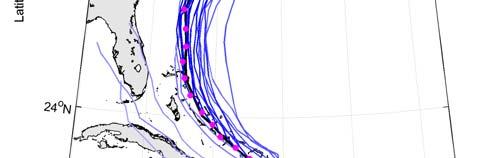
19 COAMPS-TC 2011 W. Atlantic Track Statistics (thru 10/7/11) Track Error (nm) Storm Relative Directional Decomposition COAMPS-TC Shows Some Track Forecast Deficiencies in W. Atlantic Basin. 19


20 COAMPS-TC Katia Track Statistics Track Error (nm) Track of Katia was poorly forecasted, particularly during recurvature. 20


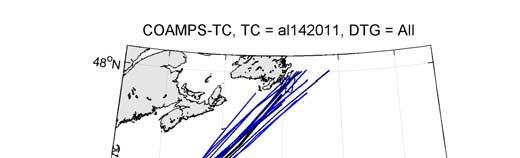
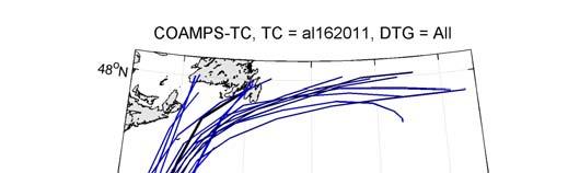
21 Irene Maria Ophelia 21

22 COAMPS-TC Eastern Pacific Basin (through 10/7/2011) Track Error (nm) Intensity Error (kt) COAMPS-TC Track Error in E. Pacific is Comparable to Other Models. Intensity Error for COAMPS-TC is Reasonably Good after 18 h. 22
23 An Overview of COAMPS-TC Development and Real-Time Tests Outline COAMPS-TC Analysis and Physics COAMPS-TC Stream 1.5 Demonstration Stream 2 Development and Real-Time Demo Summary 23
24 Serial EnKF (DART) COAMPS-TC Ensembles Data Assimilation Background Two-way interactive DA highest resolution nest defines the innovation Observations: Surface/ship stations, cloud-track winds, aircraft data, dropsondes, radiosondes, SSMI/S and WindSat TPW Distance based localization, multiplicative based inflation 80-member ensemble for DA 6-hr update cycle GFS-EnKF lateral boundary conditions GFS-EnKF fields interpolated to COAMPS grid for the initial ensemble km 2-way interactive nests for each storm Atlantic, EastPac, and WestPac 15 and 5 km nest follows storm independently for each member Nest relocated to ensemble mean position for DA 24
25 10-members (option to run 20-members) 120-h lead time twice daily (00 and 12 UTC) GFS-EnKF lateral boundary conditions Perturbations COAMPS-TC Ensembles Forecast System Background IC perturbations from members 1-10 of the DA ensemble No perturbations to model parameterizations Graphics output to web Summary plots for intensity, size, and track 15 and 15 km mesh graphics computed in storm relative coordinate 25
 TC position")


26 COAMPS-TC Ensembles Irene Probabilistic Products 10 Member 5-km Resolution Ensemble System (COAMPS-TC DART) TC position from individual ensemble members every 24 h and ellipses that encompass the 1/3 and 2/3 ensemble distributions. Median, minimum, maximum, and 10% and 90% distributions are shown COAMPS-TC Ensemble System is a new capability demonstrated in real time. 26
27 Coupled COAMPS-TC Air-Sea Interface Physics Earth System Modeling Framework (ESMF) WAVE ATMOS OCEAN ocean feedback module atmos feedback module fluxes computed in surface subroutine using ocean & wave feedback internal nested grids atmos exchange grid atmos & wave feedback used in ocean update & mixing subroutines internal nested grids ocean exchange grid ESMF interface ESMF interface ESMF interface 10-meter wind sea surface temperature Charnock sea surface height, surface current DRIVER / COUPLER sea level pressure, surface wind stress, surface heat flux, surface moisture flux, shortwave radiation Stokes drift current, wave radiation stress gradient, bottom orbital wave current COAMPS contains a community based (ESMF) coupler to facilitate flexible and generalized exchange between components 27


")
28 COAMPS-TC: ITOP Impact of Typhoons on the Ocean in Pacific ITOP Resources ONR Sponsored ITOP in W. Pacific Typhoon Fanapi: SST ( C), Currents Best Track COAMPS Satellite Derived SST Shows 2-4 C Wake Similar to Coupled Model Air-Ocean Coupling in Real Time COAMPS-TC Predicts SST Wake of 2-4 C 12Z 15 Sep h Forecast SST AMSR-E Aqua SST COAMPS-TC coupled tested in real time during ITOP in 2010 in WPAC COAMPS-TC coupled (air-ocean) capability is being tested in real time for WATL in 2011 (Stream 2) ITOP is an excellent dataset to evaluate the coupled system 28

 over 50+ cases.")
 45 km Mesh")
29 COAMPS-TC: Analysis Improvements New Synthetic Observations The current methodology places synthetic observations at fixed radial locations, out to 4-6 away from the TC center Wind Speed (knots) New Synthetics Represent the size and structure of TC better. Track is improved (~15%) over 50+ cases. The new methodology dynamically places observations at the radius of maximum winds out to the radius of the 34-knot wind Typhoon Megi ( ) 45 km Mesh Control Best New 0 29

30 Tropical Cyclone Dynamical Initialization (TCDI) Verification of TC Intensity 11 Tropical Cyclones from 2008/2009 in WPAC/WATL Time 0 h 12 h 24 h 36 h 48 h 60 h 72 h Cases TCDI improves the intensity forecasts 30
 V3.")

31 COAMPS-TC: Physics Improvements Evaluation of the Thompson Microphysics Scheme Thompson (2008) V3.3 implemented in COAMPS-TC: - two-moment for cloud ice and rain - single-moment for cloud water, snow, and graupel - prescribed number of cloud droplets (100 cm -3 ) Blue-CNTL Green-THOMP Blue-CNTL Green-THOMP 31
 Improvements to the Microphysics Mixing and New SAS Produces more Organized Convection During Intensification However, Intensity is Over-Predicted with")
32 COAMPS-TC: Physics Improvements Convection during Spin-Up of TC Radar Reflectivity for 120 hour forecasts of Celia starting at Explicit microphysics New Microphysics Mixing and New Cumulus (SAS) Improvements to the Microphysics Mixing and New SAS Produces more Organized Convection During Intensification However, Intensity is Over-Predicted with SAS. 32
33 Real-time tests in 2011 using improved COAMPS-TC WATL, EPAC, WPAC, IO: Collaborate w/ NHC, JTWC Promising COAMPS-TC Intensity Predictions Performed well in 2010 and 2011; Some excellent results in 2011 Transition to FNMOC in FY12: Validation Test Panel (underway) HFIP Stream 2 Tests and Development Ensembles: Possibility of HFIP multi-model ensemble of ensembles Fully Coupled System: Community ESMF air-sea interface for ocean & waves New Physics: Emphasis on microphysics, PBL, fluxes (joint develop. possible) Challenges and Issues Vortex-scale DA: TC Physics: Air-Sea Coupling: Probabilistic Pred.: COAMPS-TC Summary and Challenges EnKF, 4D-Var, coupled DA (all underway at NRL) Cloud microphysics, subgrid-scale convection, PBL Air-sea-wave coupled physics and interfaces Opportunities for a multi-model ensemble system 33
COAMPS-TC 2015 Version, Performance, and Future Plans
 COAMPS-TC 2015 Version, Performance, and Future Plans James D. Doyle, R. Hodur 1, J. Moskaitis, S. Chen, E. Hendricks 2, H. Jin, Y. Jin, A. Reinecke, S. Wang Naval Research Laboratory, Monterey, CA 1 IES/SAIC,
Recent COAMPS-TC Development and Future Plans
 Recent COAMPS-TC Development and Future Plans James D. Doyle, Jon Moskaitis, Rich Hodur1, Sue Chen, Hao Jin, Yi Jin, Will Komaromi, Alex Reinecke, David Ryglicki, Dan Stern2, Shouping Wang Naval Research
REAL-TIME TROPICAL CYCLONE PREDICTION USING COAMPS-TC
 Advances in Geosciences Vol. 28: Atmospheric Science and Ocean Sciences (2011) Eds. Chun-Chieh Wu and Jianping Gan c World Scientific Publishing Company REAL-TIME TROPICAL CYCLONE PREDICTION USING COAMPS-TC
Improvement of High-Resolution Tropical Cyclone Structure and Intensity Forecasts using COAMPS-TC
 DISTRIBUTION STATEMENT A. Approved for public release; distribution is unlimited. Improvement of High-Resolution Tropical Cyclone Structure and Intensity Forecasts using COAMPS-TC James D. Doyle Naval
Numerical Weather Prediction: Data assimilation. Steven Cavallo
 Numerical Weather Prediction: Data assimilation Steven Cavallo Data assimilation (DA) is the process estimating the true state of a system given observations of the system and a background estimate. Observations
2012 AHW Stream 1.5 Retrospective Results
 2012 AHW Stream 1.5 Retrospective Results Ryan D. Torn, Univ. Albany, SUNY Chris Davis, Wei Wang, Jimy Dudhia, Tom Galarneau, Chris Snyder, James Done, NCAR/NESL/MMM Overview Since participation in HFIP
HMON (HNMMB): Development of a new Hurricane model for NWS/NCEP operations
: Development of a new Hurricane model for NWS/NCEP operations") 1 HMON (HNMMB): Development of a new Hurricane model for NWS/NCEP operations Avichal Mehra, EMC Hurricane and Mesoscale Teams Environmental Modeling Center NOAA / NWS / NCEP HMON: A New Operational Hurricane
1 HMON (HNMMB): Development of a new Hurricane model for NWS/NCEP operations Avichal Mehra, EMC Hurricane and Mesoscale Teams Environmental Modeling Center NOAA / NWS / NCEP HMON: A New Operational Hurricane
Motivation & Goal. We investigate a way to generate PDFs from a single deterministic run
 Motivation & Goal Numerical weather prediction is limited by errors in initial conditions, model imperfections, and nonlinearity. Ensembles of an NWP model provide forecast probability density functions
ARW/EnKF performance for the 2009 Hurricane Season
 ARW/EnKF performance for the 2009 Hurricane Season Ryan D. Torn, Univ. at Albany, SUNY Chris Davis, Steven Cavallo, Chris Snyder, Wei Wang, James Done, NCAR/MMM 4 th EnKF Workshop 8 April 2010, Rensselaerville,
The Navy s Next-Generation Tropical Cyclone Model
 DISTRIBUTION STATEMENT A: Approved for public release; distribution is unlimited. The Navy s Next-Generation Tropical Cyclone Model James D. Doyle Naval Research Laboratory 7 Grace Hopper Ave. Monterey
NAVAL RESEARCH LABORATORY. Recent Developments in NWP
 NAVAL RESEARCH LABORATORY Recent Developments in NWP Carolyn Reynolds, Nancy Baker, James Doyle, Douglas Westphal, Melinda Peng Marine Meteorology Division, Simon Chang, Director Naval Research Laboratory,
Coupled Ocean-Wave Model Team (Team 8) Report
 Report") Coupled Ocean-Wave Model Team (Team 8) Report George Halliwell (co-lead, NOAA/AOML/PhOD) Hendrik Tolman (co-lead, NOAA/NCEP) Isaac Ginis (URI) Chris Fairall (NOAA/ESRL) Shaowu Bao (NOAA/ESRL) Jian-Wen
Coupled Ocean-Wave Model Team (Team 8) Report George Halliwell (co-lead, NOAA/AOML/PhOD) Hendrik Tolman (co-lead, NOAA/NCEP) Isaac Ginis (URI) Chris Fairall (NOAA/ESRL) Shaowu Bao (NOAA/ESRL) Jian-Wen
A Multi-Model Ensemble for Western North Pacific Tropical Cyclone Intensity Prediction
 DISTRIBUTION STATEMENT A. Approved for public release; distribution is unlimited. A Multi-Model Ensemble for Western North Pacific Tropical Cyclone Intensity Prediction Jonathan R. Moskaitis Naval Research
Overview of HFIP FY10 activities and results
 Overview of HFIP FY10 activities and results Bob Gall HFIP Annual Review Meeting Miami Nov 9, 2010 Outline In this presentation I will show a few preliminary results from the summer program. More detail
Improving Air-Sea Coupling Parameterizations in High-Wind Regimes
 Improving Air-Sea Coupling Parameterizations in High-Wind Regimes PI: Dr. Shuyi S. Chen Co-PI: Dr. Mark A. Donelan Rosenstiel School of Marine and Atmospheric Science, University of Miami 4600 Rickenbacker
Initialization of Tropical Cyclone Structure for Operational Application
 DISTRIBUTION STATEMENT A. Approved for public release; distribution is unlimited. Initialization of Tropical Cyclone Structure for Operational Application PI: Tim Li IPRC/SOEST, University of Hawaii at
Improvement of High-Resolution Tropical Cyclone Structure and Intensity Forecasts using COAMPS-TC
 DISTRIBUTION STATEMENT A. Approved for public release; distribution is unlimited. Improvement of High-Resolution Tropical Cyclone Structure and Intensity Forecasts using COAMPS-TC James D. Doyle Naval
2017 Real-time COAMPS-TC EPS
 2017 Real-time COAMPS-TC EPS Jon Moskaitis, Will Komaromi, Alex Reinecke, and Jim Doyle Naval Research Laboratory, Monterey, CA HFIP Annual Review Meeting: 8 November 2017 Typhoon Noru Hurricane Norma
NHC Ensemble/Probabilistic Guidance Products
 NHC Ensemble/Probabilistic Guidance Products Michael Brennan NOAA/NWS/NCEP/NHC Mark DeMaria NESDIS/STAR HFIP Ensemble Product Development Workshop 21 April 2010 Boulder, CO 1 Current Ensemble/Probability
Recent Advancements to the U.S. Navy s Coupled Mesoscale Modeling System. U.S. Navy Models and Tools Telescoping Strategy
 State Hwy 619 I 95 State Hwy 40 I 85 Petersburg NB I 95 US Hwy 58 US Hwy 58 State Hwy 620 1 Recent Advancements to the U.S. Navy s Coupled Mesoscale Modeling System James D. Doyle Naval Research Laboratory
HWRF Ocean: MPIPOM-TC
 HWRF v3.7a Tutorial Nanjing, China, December 2, 2015 HWRF Ocean: MPIPOM-TC Ligia Bernardet NOAA SRL Global Systems Division, Boulder CO University of Colorado CIRS, Boulder CO Acknowledgement Richard Yablonsky
The Properties of Convective Clouds Over the Western Pacific and Their Relationship to the Environment of Tropical Cyclones
 The Properties of Convective Clouds Over the Western Pacific and Their Relationship to the Environment of Tropical Cyclones Principal Investigator: Dr. Zhaoxia Pu Department of Meteorology, University
GFDL Hurricane Model Ensemble Performance During the 2012 Hurricane Season
 GFDL Hurricane Model Ensemble Performance During the 2012 Hurricane Season Tim Marchok (NOAA / GFDL) Matt Morin (DRC HPTG / GFDL) Morris Bender (NOAA / GFDL) HFIP Team Telecon 12 December 2012 Acknowledgments:
HWRF sensitivity to cumulus schemes
 HWRF sensitivity to cumulus schemes Mrinal K Biswas and Ligia R Bernardet HFIP Telecon, 01 February 2012 Motivation HFIP Regional Model Team Physics Workshop (Aug 11): Foci: Scientific issues on PBL and
Impact of Assimilating Aircraft Reconnaissance Observations in Operational HWRF
 Impact of Assimilating Aircraft Reconnaissance Observations in Operational HWRF Mingjing Tong, Vijay Tallapragada, Emily Liu, Weiguo Wang, Chanh Kieu, Qingfu Liu and Banglin Zhan Environmental Modeling
Satellite Applications to Hurricane Intensity Forecasting
 Satellite Applications to Hurricane Intensity Forecasting Christopher J. Slocum - CSU Kate D. Musgrave, Louie D. Grasso, and Galina Chirokova - CIRA/CSU Mark DeMaria and John Knaff - NOAA/NESDIS Center
The Fifth-Generation NCAR / Penn State Mesoscale Model (MM5) Mark Decker Feiqin Xie ATMO 595E November 23, 2004 Department of Atmospheric Science
 Mark Decker Feiqin Xie ATMO 595E November 23, 2004 Department of Atmospheric Science") The Fifth-Generation NCAR / Penn State Mesoscale Model (MM5) Mark Decker Feiqin Xie ATMO 595E November 23, 2004 Department of Atmospheric Science Outline Basic Dynamical Equations Numerical Methods Initialization
The Fifth-Generation NCAR / Penn State Mesoscale Model (MM5) Mark Decker Feiqin Xie ATMO 595E November 23, 2004 Department of Atmospheric Science Outline Basic Dynamical Equations Numerical Methods Initialization
Atmosphere-Ocean Interaction in Tropical Cyclones
 Atmosphere-Ocean Interaction in Tropical Cyclones Isaac Ginis University of Rhode Island Collaborators: T. Hara, Y.Fan, I-J Moon, R. Yablonsky. ECMWF, November 10-12, 12, 2008 Air-Sea Interaction in Tropical
Advancements in Operations and Research on Hurricane Modeling and Ensemble Prediction System at EMC/NOAA
 Advancements in Operations and Research on Hurricane Modeling and Ensemble Prediction System at EMC/NOAA Zhan Zhang and Vijay Tallapragada EMC/NCEP/NOAA/DOC Acknowledgements: HWRF Team Members at EMC,
Littoral Air-Sea Processes DRI Daniel Eleuterio, 322MM Scott Harper, 322PO
 Littoral Air-Sea Processes DRI Daniel Eleuterio, 322MM Scott Harper, 322PO January 7, 2009 Coupled Processes DRI Eleuterio/Harper 1 Fully Coupled Air-Wave-Ocean Forecast Models are becoming increasingly
HWRF Surface Layer Thermodynamics Evaluation. Eric W. Uhlhorn and Joseph J. Cione HFIP Hurricane Modeling Workshop September 2012
 HWRF Surface Layer Thermodynamics Evaluation Eric W. Uhlhorn and Joseph J. Cione HFIP Hurricane Modeling Workshop 17-18 September 2012 Special thanks. HRD HWRF modeling team Gopal, Xuejin Zhang, Thiago
Tropical Cyclone Modeling and Data Assimilation. Jason Sippel NOAA AOML/HRD 2018 WMO Workshop at NHC
 Tropical Cyclone Modeling and Data Assimilation Jason Sippel NOAA AOML/HRD 2018 WMO Workshop at NHC Outline History of TC forecast improvements in relation to model development Ongoing modeling/da developments
Objectives for meeting
 Objectives for meeting 1) Summarize planned experiments 2) Discuss resource availability Aircraft Instrumentation Expendables 3) Assign working groups to complete each experiment plan Flight planning and
NRL REVIEW NAVAL RESEARCH LABORATORY. Building a workforce and assembling scientific tools for the future. Washington, DC
 0 NRL REVIEW Building a workforce and assembling scientific tools for the future. NAVAL RESEARCH LABORATORY Washington, DC Report Documentation Page Form Approved OMB No. 0704-088 Public reporting burden
Some Applications of WRF/DART
 Some Applications of WRF/DART Chris Snyder, National Center for Atmospheric Research Mesoscale and Microscale Meteorology Division (MMM), and Institue for Mathematics Applied to Geoscience (IMAGe) WRF/DART
Development and testing of a coupled ocean atmosphere mesoscale ensemble prediction system
 Ocean Dynamics (2011) 61:1937 1954 DOI 10.1007/s10236-011-0449-9 Development and testing of a coupled ocean atmosphere mesoscale ensemble prediction system Teddy R. Holt & James A. Cummings & Craig H.
AHW Ensemble Data Assimilation and Forecasting System
 AHW Ensemble Data Assimilation and Forecasting System Ryan D. Torn, Univ. Albany, SUNY Chris Davis, Wei Wang, Jimy Dudhia, Tom Galarneau, Chris Snyder, James Done, NCAR/MMM Overview Since participation
DISTRIBUTION STATEMENT A: Distribution approved for public release; distribution is unlimited.
 DISTRIBUTION STATEMENT A: Distribution approved for public release; distribution is unlimited. INITIALIZATION OF TROPICAL CYCLONE STRUCTURE FOR OPERTAIONAL APPLICATION PI: Tim Li IPRC/SOEST, University
2014 real-time COAMPS-TC ensemble prediction
 2014 real-time COAMPS-TC ensemble prediction Jon Moskaitis, Alex Reinecke, Jim Doyle and the COAMPS-TC team Naval Research Laboratory, Monterey, CA HFIP annual review meeting, 20 November 2014 Real-time
Track sensitivity to microphysics and radiation
 Track sensitivity to microphysics and radiation Robert Fovell and Yizhe Peggy Bu, UCLA AOS Brad Ferrier, NCEP/EMC Kristen Corbosiero, U. Albany 11 April 2012 rfovell@ucla.edu 1 Background WRF-ARW, including
Tropical cyclone simulations and predictions with GFDL s prototype global cloud resolving model
 Tropical cyclone simulations and predictions with GFDL s prototype global cloud resolving model S.-J. Lin and GFDL model development teams NOAA/Geophysical Fluid Dynamics Laboratory Workshop on High-Resolution
A Deterministic Rapid Intensification Aid
 AUGUST 2011 S A M P S O N E T A L. 579 A Deterministic Rapid Intensification Aid CHARLES R. SAMPSON Naval Research Laboratory, Monterey, California JOHN KAPLAN NOAA/AOML/Hurricane Research Division, Miami,
Transitioning Physics Advancements into the Operational Hurricane WRF Model
 Transitioning Physics Advancements into the Operational Hurricane WRF Model KATHRYN NEWMAN, MRINAL BISWAS, LAURIE CARSON N OA A / ESR L T EA M M E M B E RS: E. K ALINA, J. F RIMEL, E. GRELL, AND L. B ERNARDET
National Oceanic and Atmospheric Administration Hurricane Forecast Improvement Program Five-Year Strategic Plan
 National Oceanic and Atmospheric Administration Hurricane Forecast Improvement Program Five-Year Strategic Plan 13 December 2010 Frederick Toepfer HFIP Program Manager Robert Gall HFIP Development Manager
Discussion on HFIP RDITT Experiments. Proposal for extending the life of RDITT for one more year: Future Plans from Individual Groups
 Discussion on HFIP RDITT Experiments Proposal for extending the life of RDITT for one more year: Future Plans from Individual Groups 1 EMC: Modifications to one-way hybrid ensemble-variational data assimilation
The Use of GPS Radio Occultation Data for Tropical Cyclone Prediction. Bill Kuo and Hui Liu UCAR
 The Use of GPS Radio Occultation Data for Tropical Cyclone Prediction Bill Kuo and Hui Liu UCAR Current capability of the National Hurricane Center Good track forecast improvements. Errors cut in half
Simulating the formation of Hurricane Katrina (2005)
") GEOPHYSICAL RESEARCH LETTERS, VOL. 35, L11802, doi:10.1029/2008gl033168, 2008 Simulating the formation of Hurricane Katrina (2005) Yi Jin, 1 Melinda S. Peng, 1 and Hao Jin 2 Received 2 January 2008; revised
GEOPHYSICAL RESEARCH LETTERS, VOL. 35, L11802, doi:10.1029/2008gl033168, 2008 Simulating the formation of Hurricane Katrina (2005) Yi Jin, 1 Melinda S. Peng, 1 and Hao Jin 2 Received 2 January 2008; revised
DA/Initialization/Ensemble Development Team Milestones and Priorities
 DA/Initialization/Ensemble Development Team Milestones and Priorities Presented by Xuguang Wang HFIP annual review meeting Jan. 11-12, 2017, Miami, FL Fully cycled, self-consistent, dual-resolution, GSI
Typhoon Relocation in CWB WRF
 Typhoon Relocation in CWB WRF L.-F. Hsiao 1, C.-S. Liou 2, Y.-R. Guo 3, D.-S. Chen 1, T.-C. Yeh 1, K.-N. Huang 1, and C. -T. Terng 1 1 Central Weather Bureau, Taiwan 2 Naval Research Laboratory, Monterey,
BASIN-SCALE HWRF: Evaluation of 2017 Real-Time Forecasts
 BASIN-SCALE HWRF: Evaluation of 2017 Real-Time Forecasts HARVEY IRMA MARIA Ghassan Alaka1,2, Xuejin Zhang1,2, Gopal2, Frank Marks2, Mu-Chieh Ko1,2, Russell St. Fleur1,2 Acknowledgements: NOAA/NWS/EMC,
Improving Surface Flux Parameterizations in the NRL Coupled Ocean/Atmosphere Mesoscale Prediction System
 Improving Surface Flux Parameterizations in the NRL Coupled Ocean/Atmosphere Mesoscale Prediction System LONG-TERM GOAL Shouping Wang Naval Research Laboratory Monterey, CA 93943 Phone: (831) 656-4719
NCEP Operational Hurricane Modeling System. HWRF Performance Verification in 2015
 1 NCEP Operational Hurricane Modeling System HWRF Performance Verification in 2015 The HWRF Team Environmental Modeling Center, NCEP NOAA/NCWCP, College Park, MD 20740, USA. Zhan Zhang, Samuel Trahan,
Recent Developments in the Navy Coastal Ocean Model and its application as the ocean component in regional coupled forecast models
 Recent Developments in the Navy Coastal Ocean Model and its application as the ocean component in regional coupled forecast models Tommy Jensen, Paul Martin, Clark Rowley, Tim Campbell, Richard Allard,
Advanced Hurricane WRF (AHW) Physics
 Physics") Advanced Hurricane WRF (AHW) Physics Jimy Dudhia MMM Division, NCAR 1D Ocean Mixed-Layer Model 1d model based on Pollard, Rhines and Thompson (1973) was added for hurricane forecasts Purpose is to represent
Advanced Hurricane WRF (AHW) Physics Jimy Dudhia MMM Division, NCAR 1D Ocean Mixed-Layer Model 1d model based on Pollard, Rhines and Thompson (1973) was added for hurricane forecasts Purpose is to represent
Using NOGAPS Singular Vectors to Diagnose Large-scale Influences on Tropical Cyclogenesis
 DISTRIBUTION STATEMENT A. Approved for public release; distribution is unlimited. Using NOGAPS Singular Vectors to Diagnose Large-scale Influences on Tropical Cyclogenesis PI: Prof. Sharanya J. Majumdar
Precipitation Structure and Processes of Typhoon Nari (2001): A Modeling Propsective
: A Modeling Propsective") Precipitation Structure and Processes of Typhoon Nari (2001): A Modeling Propsective Ming-Jen Yang Institute of Hydrological Sciences, National Central University 1. Introduction Typhoon Nari (2001) struck
Precipitation Structure and Processes of Typhoon Nari (2001): A Modeling Propsective Ming-Jen Yang Institute of Hydrological Sciences, National Central University 1. Introduction Typhoon Nari (2001) struck
Performance of the 2013 Operational HWRF
 Performance of the 2013 Operational HWRF Vijay Tallapragada & HWRF Team Environmental Modeling Center, NCEP/NOAA/NWS, NCWCP, College Park, MD 20740. HFIP Annual Review Meeting, February 19, 2014 1 Outline
The Evolution and Use of Objective Forecast Guidance at NHC
 The Evolution and Use of Objective Forecast Guidance at NHC James L. Franklin Branch Chief, Hurricane Specialist Unit National Hurricane Center 2010 EMC/MMM/DTC Workshop 1 Hierarchy of TC Track Models
Impact of GPS RO Data on the Prediction of Tropical Cyclones
 Impact of GPS RO Data on the Prediction of Tropical Cyclones Ying-Hwa Kuo, Hui Liu, UCAR Ching-Yuang Huang, Shu-Ya Chen, NCU Ling-Feng Hsiao, Ming-En Shieh, Yu-Chun Chen, TTFRI Outline Tropical cyclone
Evaluation and Improvement of HWRF PBL Physics using Aircraft Observations
 Evaluation and Improvement of HWRF PBL Physics using Aircraft Observations Jun Zhang NOAA/AOML/HRD with University of Miami/CIMAS HFIP Regional Modeling Team Workshop, 09/18/2012 Many thanks to my collaborators:
11 days (00, 12 UTC) 132 hours (06, 18 UTC) One unperturbed control forecast and 26 perturbed ensemble members. --
 132 hours (06, 18 UTC) One unperturbed control forecast and 26 perturbed ensemble members. --") APPENDIX 2.2.6. CHARACTERISTICS OF GLOBAL EPS 1. Ensemble system Ensemble (version) Global EPS (GEPS1701) Date of implementation 19 January 2017 2. EPS configuration Model (version) Global Spectral Model
APPENDIX 2.2.6. CHARACTERISTICS OF GLOBAL EPS 1. Ensemble system Ensemble (version) Global EPS (GEPS1701) Date of implementation 19 January 2017 2. EPS configuration Model (version) Global Spectral Model
Multi-scale Predictability Aspects of a Severe European Winter Storm
 1 Multi-scale Predictability Aspects of a Severe European Winter Storm NASA MODIS James D. Doyle, C. Amerault, P. A. Reinecke, C. Reynolds Naval Research Laboratory, Monterey, CA Mesoscale Predictability
Key Laboratory of Mesoscale Severe Weather, Ministry of Education, School of Atmospheric Sciences, Nanjing University
 Modeling Rapid Intensification of Typhoon Saomai (2006) with the Weather Research and Forecasting Model and Sensitivity to Cloud Microphysical Parameterizations Jie Ming and Yuan Wang Key Laboratory of
HFIP ENSEMBLE TEAM UPDATE
 HFIP ENSEMBLE TEAM UPDATE Carolyn Reynolds (NRL) carolyn.reynolds@nrlmry.navy.mil Zoltan Toth (ESRL) zoltan.toth@noaa.gov Sim Aberson (HRD) Sim.Aberson@noaa.gov Tom Hamill (ESRL) tom.hamill@noaa.gov Jeff
COUPLED OCEAN-ATMOSPHERE 4DVAR
 COUPLED OCEAN-ATMOSPHERE 4DVAR Hans Ngodock, Matthew Carrier, Clark Rowley, Tim Campbell NRL, Stennis Space Center Clark Amerault, Liang Xu, Teddy Holt NRL, Monterey 11/17/2016 International workshop on
Impact of Stochastic Convection on Ensemble Forecasts of Tropical Cyclone Development
 620 M O N T H L Y W E A T H E R R E V I E W VOLUME 139 Impact of Stochastic Convection on Ensemble Forecasts of Tropical Cyclone Development ANDREW SNYDER AND ZHAOXIA PU Department of Atmospheric Sciences,
The Effect of Sea Spray on Tropical Cyclone Intensity
 The Effect of Sea Spray on Tropical Cyclone Intensity Jeffrey S. Gall, Young Kwon, and William Frank The Pennsylvania State University University Park, Pennsylvania 16802 1. Introduction Under high-wind
Applications Development and Diagnostics (ADD) Team Summary Part 2
 Team Summary Part 2") Applications Development and Diagnostics (ADD) Team Summary Part 2 Mark DeMaria, NOAA/NESDIS HFIP Annual Review Meeting Nov. 8-9, 2011, Miami, FL Input from: Chris Davis, James Doyle, Thomas Galarneau,
Applications Development and Diagnostics (ADD) Team Summary Part 2 Mark DeMaria, NOAA/NESDIS HFIP Annual Review Meeting Nov. 8-9, 2011, Miami, FL Input from: Chris Davis, James Doyle, Thomas Galarneau,
HFIP ENSEMBLE PLAN. Jun Du (EMC/NCEP), presenting on behalf of the HFIP Ensemble Team:
, presenting on behalf of the HFIP Ensemble Team:") HFIP ENSEMBLE PLAN Jun Du (EMC/NCEP), presenting on behalf of the HFIP Ensemble Team: Sim Aberson (HRD) Sim.Aberson@noaa.gov Tom Hamill (ESRL) tom.hamill@noaa.gov Carolyn Reynolds (NRL) carolyn.reynolds@nrlmry.navy.mil
HFIP ENSEMBLE PLAN Jun Du (EMC/NCEP), presenting on behalf of the HFIP Ensemble Team: Sim Aberson (HRD) Sim.Aberson@noaa.gov Tom Hamill (ESRL) tom.hamill@noaa.gov Carolyn Reynolds (NRL) carolyn.reynolds@nrlmry.navy.mil
Weather Research and Forecasting Model. Melissa Goering Glen Sampson ATMO 595E November 18, 2004
 Weather Research and Forecasting Model Melissa Goering Glen Sampson ATMO 595E November 18, 2004 Outline What does WRF model do? WRF Standard Initialization WRF Dynamics Conservation Equations Grid staggering
A Reformulation of the Logistic Growth Equation Model (LGEM) for Ensemble and Extended Range Intensity Prediction
 for Ensemble and Extended Range Intensity Prediction") A Reformulation of the Logistic Growth Equation Model (LGEM) for Ensemble and Extended Range Intensity Prediction Mark DeMaria NOAA/NESDIS, Fort Collins, CO Andrea Schumacher and Kate Musgrave CIRA/CSU,
A Reformulation of the Logistic Growth Equation Model (LGEM) for Ensemble and Extended Range Intensity Prediction Mark DeMaria NOAA/NESDIS, Fort Collins, CO Andrea Schumacher and Kate Musgrave CIRA/CSU,
The National Weather Service of the Future: Building a Weather-Ready Nation
 The of the Future: Building a Weather-Ready Nation Dr. Louis W. Uccellini Director, NOAA Assistant Administrator for Weather Services NCEP Production Suite Review December 2, 2014 Outline Building a Weather-Ready
Hurricane Forecast Improvement Project (HFIP) Bob Gall HFIP Development Manager
 Bob Gall HFIP Development Manager") Hurricane Forecast Improvement Project (HFIP) Bob Gall HFIP Development Manager Boulder, Colorado June 26, 2012 2 The HFIP Project Vision/Goals Vision o Organize the hurricane community to dramatically
Hurricane Forecast Improvement Project (HFIP) Bob Gall HFIP Development Manager Boulder, Colorado June 26, 2012 2 The HFIP Project Vision/Goals Vision o Organize the hurricane community to dramatically
Evolution of the GFDL hurricane model in research and transition to NMC operations
 Evolution of the GFDL hurricane model in research and transition to NMC operations Robert E. Tuleya (Saic, EMC & CCPO/ODU) Morris Bender (GFDL) Isaac Ginis (URI) Tim Marchok (GFDL) URI/GSO Y. Kurihara
Post Processing of Hurricane Model Forecasts
 Post Processing of Hurricane Model Forecasts T. N. Krishnamurti Florida State University Tallahassee, FL Collaborators: Anu Simon, Mrinal Biswas, Andrew Martin, Christopher Davis, Aarolyn Hayes, Naomi
NAVAL RESEARCH LABORATORY. Recent Developments in Navy NWP
 NRL Marine Meteorology Division WGNE March 2015 1 NAVAL RESEARCH LABORATORY Recent Developments in Navy NWP Carolyn Reynolds, Nancy Baker, James Doyle, Douglas Westphal, Liang Xu, and Melinda Peng Naval
Expansion of NCEP Operational Hurricane Weather Research and Forecast (HWRF) Model Forecast Guidance to all Global Tropical Cyclones
 Model Forecast Guidance to all Global Tropical Cyclones") Expansion of NCEP Operational Hurricane Weather Research and Forecast (HWRF) Model Forecast Guidance to all Global Tropical Cyclones Dr. Vijay Tallapragada, Hurricane Team Leader & HFIP Development Manager,
Expansion of NCEP Operational Hurricane Weather Research and Forecast (HWRF) Model Forecast Guidance to all Global Tropical Cyclones Dr. Vijay Tallapragada, Hurricane Team Leader & HFIP Development Manager,
WRF Model Simulated Proxy Datasets Used for GOES-R Research Activities
 WRF Model Simulated Proxy Datasets Used for GOES-R Research Activities Jason Otkin Cooperative Institute for Meteorological Satellite Studies Space Science and Engineering Center University of Wisconsin
Tropical Cyclone Intensity and Structure Changes in relation to Tropical Cyclone Outflow
 DISTRIBUTION STATEMENT A. Approved for public release; distribution is unlimited. Tropical Cyclone Intensity and Structure Changes in relation to Tropical Cyclone Outflow Patrick A. Harr Department of
SMAP Winds. Hurricane Irma Sep 5, AMS 33rd Conference on Hurricanes and Tropical Meteorology Ponte Vedra, Florida, 4/16 4/20, 2018
 Intensity and Size of Strong Tropical Cyclones in 2017 from NASA's SMAP L-Band Radiometer Thomas Meissner, Lucrezia Ricciardulli, Frank Wentz, Remote Sensing Systems, Santa Rosa, USA Charles Sampson, Naval
Tropical Cyclone Initialization with Dynamical and Physical constraints derived from Satellite data
 International Workshop on Rapid Change Phenomena in Tropical Cyclones Haikou China, 5 9 November 2012 Tropical Cyclone Initialization with Dynamical and Physical constraints derived from Satellite data
Satellite Assimilation Activities for the NRL Atmospheric Variational Data Assimilation (NAVDAS) and NAVDAS- AR (Accelerated Representer) Systems
 and NAVDAS- AR (Accelerated Representer) Systems") Satellite Assimilation Activities for the NRL Atmospheric Variational Data Assimilation (NAVDAS) and NAVDAS- AR (Accelerated Representer) Systems Marine Meteorology Division, NRL Monterey Nancy Baker,
Satellite Assimilation Activities for the NRL Atmospheric Variational Data Assimilation (NAVDAS) and NAVDAS- AR (Accelerated Representer) Systems Marine Meteorology Division, NRL Monterey Nancy Baker,
Next Generation HWRF. HYCOM coupling. National Centers for Environmental Prediction. HWRF & HYCOM modeling team. Environmental Modeling Center
 HWRF tutorial 1 Next Generation HWRF HYCOM coupling Hyun-Sook Kim HWRF & HYCOM modeling team 2018 HWRF Tutorial Environmental Modeling Center National Centers for Environmental Prediction US National Weather
Convection-Resolving NWP with WRF. Section coordinator Ming Xue University of Oklahoma
 Convection-Resolving NWP with WRF Section coordinator Ming Xue University of Oklahoma Convection-resolving NWP Is NWP that explicitly treats moist convective systems ranging from organized MCSs to individual
Typhoon-Ocean Interaction: The Ocean Response to Typhoons, and Its Feedback to Typhoon Intensity Synergy of Observations and Model Simulations
 DISTRIBUTION STATEMENT A. Approved for public release; distribution is unlimited. Typhoon-Ocean Interaction: The Ocean Response to Typhoons, and Its Feedback to Typhoon Intensity Synergy of Observations
Fernando Prates. Evaluation Section. Slide 1
 Fernando Prates Evaluation Section Slide 1 Objectives Ø Have a better understanding of the Tropical Cyclone Products generated at ECMWF Ø Learn the recent developments in the forecast system and its impact
Improved Tropical Cyclone Boundary Layer Wind Retrievals. From Airborne Doppler Radar
 Improved Tropical Cyclone Boundary Layer Wind Retrievals From Airborne Doppler Radar Shannon L. McElhinney and Michael M. Bell University of Hawaii at Manoa Recent studies have highlighted the importance
P Hurricane Danielle Tropical Cyclogenesis Forecasting Study Using the NCAR Advanced Research WRF Model
 P1.2 2004 Hurricane Danielle Tropical Cyclogenesis Forecasting Study Using the NCAR Advanced Research WRF Model Nelsie A. Ramos* and Gregory Jenkins Howard University, Washington, DC 1. INTRODUCTION Presently,
Ensemble Prediction Systems
 Ensemble Prediction Systems Eric Blake National Hurricane Center 7 March 2017 Acknowledgements to Michael Brennan 1 Question 1 What are some current advantages of using single-model ensembles? A. Estimates
Quantifying Uncertainty through Global and Mesoscale Ensembles
 Quantifying Uncertainty through Global and Mesoscale Ensembles Teddy R. Holt Naval Research Laboratory Monterey CA 93943-5502 phone: (831) 656-4740 fax: (831) 656-4769 e-mail: holt@nrlmry.navy.mil Award
Experiments of Hurricane Initialization with Airborne Doppler Radar Data for the Advancedresearch Hurricane WRF (AHW) Model
 Model") Experiments of Hurricane Initialization with Airborne Doppler Radar Data for the Advancedresearch Hurricane WRF (AHW) Model Qingnong Xiao 1, Xiaoyan Zhang 1, Christopher Davis 1, John Tuttle 1, Greg Holland
Experiments of Hurricane Initialization with Airborne Doppler Radar Data for the Advancedresearch Hurricane WRF (AHW) Model Qingnong Xiao 1, Xiaoyan Zhang 1, Christopher Davis 1, John Tuttle 1, Greg Holland
Quantifying Uncertainty through Global and Mesoscale Ensembles
 Quantifying Uncertainty through Global and Mesoscale Ensembles Teddy R. Holt Naval Research Laboratory Monterey CA 93943-5502 phone: (831) 656-4740 fax: (831) 656-4769 e-mail: holt@nrlmry.navy.mil Award
NWS Operational Marine and Ocean Forecasting. Overview. Ming Ji. Ocean Prediction Center National Weather Service/NCEP. CIOSS/CoRP
 NWS Operational Marine and Ocean Forecasting Overview Ming Ji Ocean Prediction Center National Weather Service/NCEP CIOSS/CoRP CoRP Symposium Corvallis, OR Aug. 12-13, 13, 2008 Titanic Telegram Marine
HYCOM and GODAE in Relation to Navy Ocean Prediction
 HYCOM and GODAE in Relation to Navy Ocean Prediction An Overview Presented by Harley Hurlburt Naval Research Laboratory Stennis Space Center, MS 39529-5004 5004 HYCOM Meeting Naval Research Laboratory
Lightning Data Assimilation using an Ensemble Kalman Filter
 Lightning Data Assimilation using an Ensemble Kalman Filter G.J. Hakim, P. Regulski, Clifford Mass and R. Torn University of Washington, Department of Atmospheric Sciences Seattle, United States 1. INTRODUCTION
Hurricane Structure: Theory and Diagnosis
 Hurricane Structure: Theory and Diagnosis 7 March, 2016 World Meteorological Organization Workshop Chris Landsea Chris.Landsea@noaa.gov National Hurricane Center, Miami Outline Structure of Hurricanes
HFIP Coupling Working Group
 HFIP Coupling Working Group Progress report with contributions of Tolman (NCEP), Chen (NRL), Ginis (URI) Hendrik L. Tolman Chief, Marine Modeling and Analysis Branch NOAA / NWS / NCEP / EMC Hendrik.Tolman@NOAA.gov
Improving Tropical Cyclone Forecasts by Assimilating Microwave Sounder Cloud-Screened Radiances and GPM precipitation measurements
 Improving Tropical Cyclone Forecasts by Assimilating Microwave Sounder Cloud-Screened Radiances and GPM precipitation measurements Hyojin Han a, Jun Li a, Mitch Goldberg b, Pei Wang a,c, Jinlong Li a,
Current and Future Experiments to Improve Assimilation of Surface Winds from Satellites in Global Models
 Current and Future Experiments to Improve Assimilation of Surface Winds from Satellites in Global Models Sharan Majumdar, RSMAS/UMiami Bob Atlas, NOAA/AOML Current and Future Collaborators: Ryan Torn (SUNY
Operational Hurricane Modeling at NCEP/EMC
 Operational Hurricane Modeling at NCEP/EMC Avichal Mehra Hurricane Project Lead Environmental Modeling Center NOAA / NWS / NCEP ESCAP/WMO Typhoon Committee 49 th Session 21-24 February 2017, Yokohama,