Tropical Cyclone Initialization with Dynamical and Physical constraints derived from Satellite data
|
|
|
- Rhoda Mitchell
- 6 years ago
- Views:
Transcription
1 International Workshop on Rapid Change Phenomena in Tropical Cyclones Haikou China, 5 9 November 2012 Tropical Cyclone Initialization with Dynamical and Physical constraints derived from Satellite data Ma Lei Ming 1, Bao Xu Wei 1, Liu Jian Yong 2, Wang Dongliang 1 and Huang Wei 1 1. Shanghai Typhoon Institute, Shanghai, Ningbo Meteorological Observatory, Ningbo, Corresponding Author: Ma Lei Ming, malm@mail.typhoon.gov.cn Acknowledgement: Sponsored by National Typhoon 973 project of China
2 Outline Background Methods Verification on Typhoon Prediction Future work
 Track in")

3 umerical Prediction Error of Tropical Cyclone (TC) Track in Northwest Pacific Numerical Model Error + Initial Error Initial error
4 Early approaches for Vortex initialization Liu et al Relocation Relocation Cycle BOGUS BDA Zou et al Pu et al Zhang X. Y., B. Wang, et al , Operational use of BDA in Shanghai BDA+Cycle Wang D., Xudong Liang et al., Weather and Forecasting, 2008,


5 Uses of Satellite Data in TC initialization

6 Initialization with diabatic heating derived from satellite rainfall (Ma Leiming et al. 2007) OBS RDH1 CTRL RDH2
7 TRMM/TMI Rain Rate TRMM/TMI rain rate assimilation Adjoint of Convective Parameterization Ma et al (a ) TRMM Rain Rate (b) 1020 Typhoon Danas(2001) Intensity NO 4DVAR 990 (c) OBS CTL NB BT BNT TRMM 4DVAR


8 4DVAR of Cloud-drift Winds (Wang Dongliang, et al. 2006; Wea Forecast)
9 The use of AMSU data (Wang et al.,sti) AMSUstatis tics
10 The 3dvar of QuikSCAT data (Zeng et al. 2005)
11 However, Deficiencies in these uses of satellite data

12 No cloud drift wind in the TC core region because of obstruction of cloud
13 The Statistical and Empirical vertical heating derived from satellite might not appropriate for the rapid change of TC
14 TRMM rain rate Evolution of TC intensity TRMM OBS CTL NB BT BNT In TRMM rainfall assimilation, the bogus data is required to be used for better prediction of TC intensity OBS


15 QuikSCAT wind 3dvar The sea wind information is introduced to the model based on geostrophic approximation
16 Any approach to avoid these deficiencies? Instead of using 3dvar and geostrophic approximation based on QuikSCAT sea winds: Suggested dynamical constraint: Gradient wind balance and TC PBL rolls by using PBL model in TC initialization. Instead of using cloud drift wind and empirical heating structure derived from cloud and TBB: Suggested Physical constraint: Moisture and latent heating structure (moisture) physically related to TBB
17 Method 1: TC Vortex Initialization with Retrieved Variables (wind and pressure) from QuikSCAT (VIRV) based on consideration of Gradient wind and PBL rolls The QuikSCAT data can also be replaced by other surface datasets, e.g., ASCAT, WINDSAT, DOPPLER RADAR


18 VIRV Vs SLP Bogus The Fujita Bogus TC The TC structure derived from VIRV QuikSCAT winds SLP VS PBL model Symmetric Bogus Vortex SLP Asymmetric Vortex


19 Retrieve the SLP from sea wind based on UWPBL model and modification on roughness parameterization Sea Surface wind field Geostrophic relation Surface friction Courtesy of R. A. Brown and Patoux, University of Washington References: Patoux (2002, 2003, 2008) PBL rolls Drag coefficient for strong wind Gradient field of Surface pressure Buoy PRES OBS Ship PRES OBS Surface pressure
20 Cd decreases with strong wind speed(powell, 2 Enhances the roughness/cd parameterization
21 Ma and Tan, 2010
22 The popular 3dvar/4dvar scheme Geostrophic approximation in 3dvar Simplified Physics in 4dvar scheme Not appropriate for TC Primitive equations Initialization Prediction Initial Time of Prediction Dynamical unbalanced prediction The VIRV scheme Gradient approximation PBL rolls secondary circulation Drag coefficient Primitive equations More appropriate for TC Initialization Prediction Initial Time of Prediction Dynamical balanced prediction


23 CTRL SCAT TC Morakot (2009) Stream and intensity of wind 0712


24 The impact of VIRV on TC prediction (Max wind MWS; Sea Level Pressure MSLP) (CTRL control; REXP1 no modification of UWPBL; REXP2 modify UWPBL) 24h TC Intensity prediction improved by 20%, track by 15%

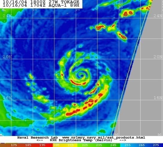
25 a b CTRL VIRV c
26 TC Morakot (2009)


27 Accumulated rainfall CTRL VIRV OBS


28 CTRL QuikSCAT wind + Radar DBZ VIRV&DBZ OBS DBZ VIRV

29 Method 2: Physical constraint TC initialization by Moisture nudging with FY2 TBB


30 TBBàMoisture à TC Convection à TC initialization Downdraft of convection TBB Updraft of convection Deep Convection Kain (2004) Environmental humidity is obviously important here, consistent with its operative role in determining downdraft strength (Knupp and Cotton 1985; Tompkins 2001) and precipitation efficiency (Ferrier et al. 1996; Shepherd et al. 2001). Latent heating Moisture adjustment according to the difference of TBB between model and observation
31 The relation between temperature and moisture (water vapor) Warmer air can hold more water vapor at equilibrium than colder air. If air is cooled below the saturation temperature, some of the water vapor condenses into liquid, which releases latent heat and warms the air. Thus, temperature and water vapor interact in a way that cannot be neglected. Tetens formula e s = e 0 b ( T T exp T T 2 1 )
32 where qsat is the saturation mixing ratio with respect to liquid water above 0 C. Below 0 C, a mixed phase cloud is considered and qsat is evaluated using a combination of saturation mixing ratio over liquid water and ice from Tetens formula. ν(k) is a weighting function that identifies the portion of the vertical profile modified by the nudging procedure.

33 TBB observed by FY2C and that retrieved from numerical model FY2C Model 5 hours 7 hours 13 hours
34 The moisture nudging cycle NCEP/GFS Background fields TBB TBB TBB TBB nudging nudging nudging nudging 6h fcst 6h fcst 6h fcst 6h fcst 72h fcst 24h 18h 12h 6h 0h (Initial time) 24h nudging cycle
35 Rankine vortex (left) Vs moisture nudging (right) (a) (b) (c) (d)

36 (a) (b) (c) (d) (e) (radius of forcing: a:96km;b: 120km;c: 150km;d:300km)
37 Minimum sea level pressure (hpa) (a) Obs None WRFBogus Cntl Exp1 Exp2 Maximum 10 m wind speed (m s 1 ) (b) Time (hour) Time (hour) Obs None WRFBogus Cntl Exp1 Exp2
38 Future Work Further verification on the performance of the new initialization schemes with more TC cases. Better understanding of the mechanism of TC initialization in association with the dynamical and physical constraint. Join the dynamic and physical constraint in TC initialization Enhancing TC model physics and dynamics on the basis of TC initialization.


39 Can we Bridge the TC physics and Initialization? ( 3.3.html)

40 Numerical Prediction Tasks for China Typhoon 973 project
41 Thank you very much!
Precipitation Structure and Processes of Typhoon Nari (2001): A Modeling Propsective
: A Modeling Propsective") Precipitation Structure and Processes of Typhoon Nari (2001): A Modeling Propsective Ming-Jen Yang Institute of Hydrological Sciences, National Central University 1. Introduction Typhoon Nari (2001) struck
Precipitation Structure and Processes of Typhoon Nari (2001): A Modeling Propsective Ming-Jen Yang Institute of Hydrological Sciences, National Central University 1. Introduction Typhoon Nari (2001) struck
Operational Use of Scatterometer Winds in the JMA Data Assimilation System
 Operational Use of Scatterometer Winds in the Data Assimilation System Masaya Takahashi Numerical Prediction Division, Japan Meteorological Agency () International Ocean Vector Winds Science Team Meeting,
The Use of GPS Radio Occultation Data for Tropical Cyclone Prediction. Bill Kuo and Hui Liu UCAR
 The Use of GPS Radio Occultation Data for Tropical Cyclone Prediction Bill Kuo and Hui Liu UCAR Current capability of the National Hurricane Center Good track forecast improvements. Errors cut in half
Key Laboratory of Mesoscale Severe Weather, Ministry of Education, School of Atmospheric Sciences, Nanjing University
 Modeling Rapid Intensification of Typhoon Saomai (2006) with the Weather Research and Forecasting Model and Sensitivity to Cloud Microphysical Parameterizations Jie Ming and Yuan Wang Key Laboratory of
Impact of GPS RO Data on the Prediction of Tropical Cyclones
 Impact of GPS RO Data on the Prediction of Tropical Cyclones Ying-Hwa Kuo, Hui Liu, UCAR Ching-Yuang Huang, Shu-Ya Chen, NCU Ling-Feng Hsiao, Ming-En Shieh, Yu-Chun Chen, TTFRI Outline Tropical cyclone
Radiance Data Assimilation with an EnKF
 Radiance Data Assimilation with an EnKF Zhiquan Liu, Craig Schwartz, Xiangyu Huang (NCAR/MMM) Yongsheng Chen (York University) 4/7/2010 4th EnKF Workshop 1 Outline Radiance Assimilation Methodology Apply
Operational Use of Scatterometer Winds at JMA
 Operational Use of Scatterometer Winds at JMA Masaya Takahashi Numerical Prediction Division, Japan Meteorological Agency (JMA) 10 th International Winds Workshop, Tokyo, 26 February 2010 JMA Outline JMA
A High-Quality Tropical Cyclone Reanalysis Dataset Using 4DVAR Data Assimilation Technique
 A High-Quality Tropical Cyclone Reanalysis Dataset Using 4DVAR Data Assimilation Technique Prof. Tim Li IPRC/University of Hawaii and Dr. Fuzhong Weng, Chief Sensor Physics Branch NOAA/NESDIS/Office of
Tropical cyclone forecasting with model-constrained 3D-Var. II: Improved cyclone track forecasting using AMSU-A, QuikSCAT and cloud-drift wind data
 QUARTERLY JOURNAL OF THE ROYAL METEOROLOGICAL SOCIETY Q. J. R. Meteorol. Soc. 133: 155 165 (27) Published online in Wiley InterScience (www.interscience.wiley.com) DOI: 1.12/qj.1 Tropical cyclone forecasting
11/19/14. Chapter 11: Hurricanes. The Atmosphere: An Introduction to Meteorology, 12 th. Lutgens Tarbuck
 Chapter 11: Hurricanes The Atmosphere: An Introduction to Meteorology, 12 th Lutgens Tarbuck Lectures by: Heather Gallacher, Cleveland State University! Hurricanes: " Hurricanes are intense centers of
Preliminary evaluation of the impact of. cyclone assimilation and prediction
 Preliminary evaluation of the impact of the FORMOSAT 7R wind on tropical cyclone assimilation and prediction Shu Chih Yang 1,2, Cheng Chieh Kao 1,2, Wen Hao Yeh 3 and Stefani Huang 1 1 Dept. of Atmospheric
APPLICATIONS OF SEA-LEVEL PRESSURE
 APPLICATIONS OF SEA-LEVEL PRESSURE RETRIEVAL FROM SCATTEROMETER WINDS Jérôme Patoux, Ralph C. Foster and Robert A. Brown OVWST meeting Seattle, November 20, 2008 Pressure retrieval: how does it work? model
A New Typhoon Bogus Data Assimilation and its Sampling Method: A Case Study
 ATMOSPHERIC AND OCEANIC SCIENCE LETTERS, 2011, VOL. 4, NO. 5, 276 280 A New Typhoon Bogus Data Assimilation and its Sampling Method: A Case Study WANG Shu-Dong 1,2, LIU Juan-Juan 2, and WANG Bin 2 1 Meteorological
Application of Radio Occultation Data in Analyses and Forecasts of Tropical Cyclones Using an Ensemble Assimilation System
 Application of Radio Occultation Data in Analyses and Forecasts of Tropical Cyclones Using an Assimilation System Hui Liu, Jeff Anderson, and Bill Kuo NCAR Acknowledgment: C. Snyder, Y. Chen, T. Hoar,
Forecast of hurricane track and intensity with advanced IR soundings
 Forecast of hurricane track and intensity with advanced IR soundings Jun Li @, Hui Liu #, Jinlong Li @, and Tim Schmit & @CIMSS/SSEC, University of Wisconsin-Madison #National Center for Atmospheric Research
Tropical Cyclone Modeling and Data Assimilation. Jason Sippel NOAA AOML/HRD 2018 WMO Workshop at NHC
 Tropical Cyclone Modeling and Data Assimilation Jason Sippel NOAA AOML/HRD 2018 WMO Workshop at NHC Outline History of TC forecast improvements in relation to model development Ongoing modeling/da developments
The Nowcasting Demonstration Project for London 2012
 The Nowcasting Demonstration Project for London 2012 Susan Ballard, Zhihong Li, David Simonin, Jean-Francois Caron, Brian Golding, Met Office, UK Introduction The success of convective-scale NWP is largely
The Properties of Convective Clouds Over the Western Pacific and Their Relationship to the Environment of Tropical Cyclones
 The Properties of Convective Clouds Over the Western Pacific and Their Relationship to the Environment of Tropical Cyclones Principal Investigator: Dr. Zhaoxia Pu Department of Meteorology, University
DISTRIBUTION STATEMENT A: Distribution approved for public release; distribution is unlimited.
 DISTRIBUTION STATEMENT A: Distribution approved for public release; distribution is unlimited. INITIALIZATION OF TROPICAL CYCLONE STRUCTURE FOR OPERTAIONAL APPLICATION PI: Tim Li IPRC/SOEST, University
AVIATION APPLICATIONS OF A NEW GENERATION OF MESOSCALE NUMERICAL WEATHER PREDICTION SYSTEM OF THE HONG KONG OBSERVATORY
 P452 AVIATION APPLICATIONS OF A NEW GENERATION OF MESOSCALE NUMERICAL WEATHER PREDICTION SYSTEM OF THE HONG KONG OBSERVATORY Wai-Kin WONG *1, P.W. Chan 1 and Ivan C.K. Ng 2 1 Hong Kong Observatory, Hong
Interpretation of Polar-orbiting Satellite Observations. Atmospheric Instrumentation
 Interpretation of Polar-orbiting Satellite Observations Outline Polar-Orbiting Observations: Review of Polar-Orbiting Satellite Systems Overview of Currently Active Satellites / Sensors Overview of Sensor
Outline of 4 Lectures
 Outline of 4 Lectures 1. Sept. 17, 2008: TC best track definition and datasets, global distribution of TCs; Review of history of meteorological satellites, introducing different orbits, scanning patterns,
Microwave-TC intensity estimation. Ryo Oyama Meteorological Research Institute Japan Meteorological Agency
 Microwave-TC intensity estimation Ryo Oyama Meteorological Research Institute Japan Meteorological Agency Contents 1. Introduction 2. Estimation of TC Maximum Sustained Wind (MSW) using TRMM Microwave
Module 11: Meteorology Topic 5 Content: Weather Maps Notes
 Introduction A variety of weather maps are produced by the National Weather Service and National Oceanographic Atmospheric Administration. These maps are used to help meteorologists accurately predict
Study on Air-Sea Interaction under Typhoon and Its Application of Two Important Projects
 ESCAP/WMO Typhoon Committee Technical Conference (TC50 TECO) Study on Air-Sea Interaction under Typhoon and Its Application of Two Important Projects Li Yongping Shanghai Typhoon Institute/CMA 2018.02.26
Numerical Experiments of Tropical Cyclone Seasonality over the Western North Pacific
 Numerical Experiments of Tropical Cyclone Seasonality over the Western North Pacific Dong-Kyou Lee School of Earth and Environmental Sciences Seoul National University, Korea Contributors: Suk-Jin Choi,
A 3DVAR-Based Dynamical Initialization Scheme for Tropical Cyclone Predictions*
 APRIL 2012 Z H A N G E T A L. 473 A 3DVAR-Based Dynamical Initialization Scheme for Tropical Cyclone Predictions* SHENGJUN ZHANG State Key Laboratory of Severe Weather, Chinese Academy of Meteorological
Impact of FORMOSAT 3/COSMIC Radio Occultation. near Taiwan
 Impact of FORMOSAT 3/COSMIC Radio Occultation Data on Predictions i of Typhoon and Mei yu Fronts near Taiwan CHING YUANG HUANG 1,2, CHAN SENG WONG 1, CHIEN JU WANG 2, and CHIN CHENG TSAI 2 1 Department
Initialization of Tropical Cyclone Structure for Operational Application
 DISTRIBUTION STATEMENT A. Approved for public release; distribution is unlimited. Initialization of Tropical Cyclone Structure for Operational Application PI: Tim Li IPRC/SOEST, University of Hawaii at
Status and Plans of using the scatterometer winds in JMA's Data Assimilation and Forecast System
 Status and Plans of using the scatterometer winds in 's Data Assimilation and Forecast System Masaya Takahashi¹ and Yoshihiko Tahara² 1- Numerical Prediction Division, Japan Meteorological Agency () 2-
2B.6 LATEST DEVELOPMENT OF 3DVAR SYSTEM FOR ARPS AND ITS APPLICATION TO A TORNADIC SUPERCELL STORM. Guoqing Ge * and Jidong Gao
 2B.6 LATEST DEVELOPMENT OF 3DVAR SYSTEM FOR ARPS AND ITS APPLICATION TO A TORNADIC SUPERCELL STORM Guoqing Ge * and Jidong Gao Center for Analysis and Prediction of Storms and school of meteorology, University
Research on Climate of Typhoons Affecting China
 Research on Climate of Typhoons Affecting China Xu Ming Shanghai Typhoon Institute November,25 Outline 1. Introduction 2. Typhoon disasters in China 3. Climatology and climate change of typhoon affecting
The impact of assimilation of microwave radiance in HWRF on the forecast over the western Pacific Ocean
 The impact of assimilation of microwave radiance in HWRF on the forecast over the western Pacific Ocean Chun-Chieh Chao, 1 Chien-Ben Chou 2 and Huei-Ping Huang 3 1Meteorological Informatics Business Division,
Earth Observatory, Columbia University
 Satellite-Based Mid dlatitude Cyclone Statistics Over the Southern Ocean -- Tracks and Su urface Fluxes Xiaojun Yuan August 19, 2009 In collaboration with Jérôme Pato oux at University of Washington and
Nanjing University, Nanjing , China. Oklahoma, Norman, Oklahoma, USA, October, Submitted to Journal of Geophysical Research
 Implementation of a Dynamic Equation Constraint based on the Steady State Momentum Equations within the WRF Hybrid Ensemble-3DVar Data Assimilation System and Test with Radar T-TREC Wind Assimilation for
Advances in weather modelling
 Advances in weather modelling www.cawcr.gov.au Robert Fawcett - speaking on behalf of CAWCR Earth-System Modelling and CAWCR Weather and Environmental Prediction May 2013 The Centre for Australian Weather
Hurricane Structure: Theory and Diagnosis
 Hurricane Structure: Theory and Diagnosis 7 March, 2016 World Meteorological Organization Workshop Chris Landsea Chris.Landsea@noaa.gov National Hurricane Center, Miami Outline Structure of Hurricanes
Some Applications of WRF/DART
 Some Applications of WRF/DART Chris Snyder, National Center for Atmospheric Research Mesoscale and Microscale Meteorology Division (MMM), and Institue for Mathematics Applied to Geoscience (IMAGe) WRF/DART
Assessment of AHI Level-1 Data for HWRF Assimilation
 Assessment of AHI Level-1 Data for HWRF Assimilation Xiaolei Zou 1 and Fuzhong Weng 2 1 Earth System Science Interdisciplinary Center, University of Maryland, College Park, Maryland 2 Satellite Meteorology
Tropical Cyclone Mesoscale Data Assimilation
 Tropical Cyclone Mesoscale Data Assimilation Sharan Majumdar (RSMAS / U. Miami) Chris Velden (CIMSS / U. Wisconsin) Acknowledgments: Ryan Torn (SUNY at Albany), Altug Aksoy and Tomislava Vukicevic (NOAA/AOML/HRD)
Observing System Experiments using a singular vector method for 2004 DOTSTAR cases
 Observing System Experiments using a singular vector method for 2004 DOTSTAR cases Korea-Japan-China Second Joint Conference on Meteorology 11 OCT. 2006 Munehiko YAMAGUCHI 1 Takeshi IRIGUCHI 1 Tetsuo NAKAZAWA
Impact of METOP ASCAT Ocean Surface Winds in the NCEP GDAS/GFS and NRL NAVDAS
 Impact of METOP ASCAT Ocean Surface Winds in the NCEP GDAS/GFS and NRL NAVDAS COAMPS @ Li Bi 1,2 James Jung 3,4 Michael Morgan 5 John F. Le Marshall 6 Nancy Baker 2 Dave Santek 3 1 University Corporation
The Impacts of GPS Radio Occultation Data on the Analysis and Prediction of Tropical Cyclones. Bill Kuo, Xingqin Fang, and Hui Liu UCAR COSMIC
 The Impacts of GPS Radio Occultation Data on the Analysis and Prediction of Tropical Cyclones Bill Kuo, Xingqin Fang, and Hui Liu UCAR COSMIC GPS Radio Occultation α GPS RO observations advantages for
Unit 5 Lesson 3 How is Weather Predicted? Copyright Houghton Mifflin Harcourt Publishing Company
 Tracking the Weather Warm up 1 Why is it important to watch the weather forecast before traveling to another country? Tracking the Weather A meteorologist is a scientist who studies weather. Meteorologists
Hurricanes are intense vortical (rotational) storms that develop over the tropical oceans in regions of very warm surface water.
 storms that develop over the tropical oceans in regions of very warm surface water.") Hurricanes: Observations and Dynamics Houze Section 10.1. Holton Section 9.7. Emanuel, K. A., 1988: Toward a general theory of hurricanes. American Scientist, 76, 371-379 (web link). http://ww2010.atmos.uiuc.edu/(gh)/guides/mtr/hurr/home.rxml
Hurricanes: Observations and Dynamics Houze Section 10.1. Holton Section 9.7. Emanuel, K. A., 1988: Toward a general theory of hurricanes. American Scientist, 76, 371-379 (web link). http://ww2010.atmos.uiuc.edu/(gh)/guides/mtr/hurr/home.rxml
Untitled.notebook May 12, Thunderstorms. Moisture is needed to form clouds and precipitation the lifting of air, or uplift, must be very strong
 Thunderstorms Moisture is needed to form clouds and precipitation the lifting of air, or uplift, must be very strong cold air and warm air must mix; creating an active circulation system that has both
Impact of different cumulus parameterizations on the numerical simulation of rain over southern China
 Impact of different cumulus parameterizations on the numerical simulation of rain over southern China P.W. Chan * Hong Kong Observatory, Hong Kong, China 1. INTRODUCTION Convective rain occurs over southern
Lecture 19: Operational Remote Sensing in Visible, IR, and Microwave Channels
 MET 4994 Remote Sensing: Radar and Satellite Meteorology MET 5994 Remote Sensing in Meteorology Lecture 19: Operational Remote Sensing in Visible, IR, and Microwave Channels Before you use data from any
Application of FY-2C Cloud Drift Winds in a Mesoscale Numerical Model
 740 ACTA METEOROLOGICA SINICA VOL.24 Application of FY-2C Cloud Drift Winds in a Mesoscale Numerical Model LI Huahong 1,2 ( ), WANG Man 3 ( ), XUE Jishan 4 ( ), and QI Minghui 2 ( ) 1 Department of Atmospheric
Mr. P s Science Test!
 WEATHER- 2017 Mr. P s Science Test! # Name Date 1. Draw and label a weather station model. (10 pts) 2. The is the layer of the atmosphere with our weather. 3. Meteorologists classify clouds in about different
The Properties of Convective Clouds over the Western Pacific and Their Relationship to the Environment of Tropical Cyclones
 DISTRIBUTION STATEMENT A. Approved for public release; distribution is unlimited. The Properties of Convective Clouds over the Western Pacific and Their Relationship to the Environment of Tropical Cyclones
Comparison of Typhoon Track Forecast using Dynamical Initialization Schemeinstalled
 IWTC-LP 9 Dec 2014, Jeju, Korea Comparison of Typhoon Track Forecast using Dynamical Initialization Schemeinstalled WRF Hyeonjin Shin, WooJeong Lee, KiRyong Kang, 1) Dong-Hyun Cha and Won-Tae Yun National
NUMERICAL SIMULATION OF A BAY OF BENGAL TROPICAL CYCLONE: A COMPARISON OF THE RESULTS FROM EXPERIMENTS WITH JRA-25 AND NCEP REANALYSIS FIELDS
 NUMERICAL SIMULATION OF A BAY OF BENGAL TROPICAL CYCLONE: A COMPARISON OF THE RESULTS FROM EXPERIMENTS WITH JRA-25 AND NCEP REANALYSIS FIELDS Dodla Venkata Bhaskar Rao Desamsetti Srinivas and Dasari Hari
Fernando Prates. Evaluation Section. Slide 1
 Fernando Prates Evaluation Section Slide 1 Objectives Ø Have a better understanding of the Tropical Cyclone Products generated at ECMWF Ø Learn the recent developments in the forecast system and its impact
ABSTRACT 3 RADIAL VELOCITY ASSIMILATION IN BJRUC 3.1 ASSIMILATION STRATEGY OF RADIAL
 REAL-TIME RADAR RADIAL VELOCITY ASSIMILATION EXPERIMENTS IN A PRE-OPERATIONAL FRAMEWORK IN NORTH CHINA Min Chen 1 Ming-xuan Chen 1 Shui-yong Fan 1 Hong-li Wang 2 Jenny Sun 2 1 Institute of Urban Meteorology,
Development of an Hourly- Updated NAM Forecast System
 Development of an Hourly- Updated NAM Forecast System Jacob Carley ab, Eric Rogers b, Shun Liu ab, Brad Ferrier ab, Eric Aligo ab, Matthew Pyle b, and Geoff DiMego b a IMSG, b NOAA/NWS/NCEP/EMC jacob.carley@noaa.gov
Satellite Applications to Hurricane Intensity Forecasting
 Satellite Applications to Hurricane Intensity Forecasting Christopher J. Slocum - CSU Kate D. Musgrave, Louie D. Grasso, and Galina Chirokova - CIRA/CSU Mark DeMaria and John Knaff - NOAA/NESDIS Center
Evaluation and Improvement of HWRF PBL Physics using Aircraft Observations
 Evaluation and Improvement of HWRF PBL Physics using Aircraft Observations Jun Zhang NOAA/AOML/HRD with University of Miami/CIMAS HFIP Regional Modeling Team Workshop, 09/18/2012 Many thanks to my collaborators:
Observations of Mediterranean Precipitating Systems using AMSU
 Observations of Mediterranean Precipitating Systems using AMSU Beatriz FUNATSU 1, Chantal CLAUD 1 and Jean-Pierre CHABOUREAU 2 1 Laboratoire de Meteorologie Dynamique/IPSL, Palaiseau 2 Laboratoire d Aerologie/CNRS-UPS,
ATMOSPHERIC MODELLING. GEOG/ENST 3331 Lecture 9 Ahrens: Chapter 13; A&B: Chapters 12 and 13
 ATMOSPHERIC MODELLING GEOG/ENST 3331 Lecture 9 Ahrens: Chapter 13; A&B: Chapters 12 and 13 Agenda for February 3 Assignment 3: Due on Friday Lecture Outline Numerical modelling Long-range forecasts Oscillations
Direct assimilation of all-sky microwave radiances at ECMWF
 Direct assimilation of all-sky microwave radiances at ECMWF Peter Bauer, Alan Geer, Philippe Lopez, Deborah Salmond European Centre for Medium-Range Weather Forecasts Reading, Berkshire, UK Slide 1 17
The prognostic deep convection parametrization for operational forecast in horizontal resolutions of 8, 4 and 2 km
 The prognostic deep convection parametrization for operational forecast in horizontal resolutions of 8, 4 and 2 km Martina Tudor, Stjepan Ivatek-Šahdan and Antonio Stanešić tudor@cirus.dhz.hr Croatian
Experiments of Hurricane Initialization with Airborne Doppler Radar Data for the Advancedresearch Hurricane WRF (AHW) Model
 Model") Experiments of Hurricane Initialization with Airborne Doppler Radar Data for the Advancedresearch Hurricane WRF (AHW) Model Qingnong Xiao 1, Xiaoyan Zhang 1, Christopher Davis 1, John Tuttle 1, Greg Holland
Experiments of Hurricane Initialization with Airborne Doppler Radar Data for the Advancedresearch Hurricane WRF (AHW) Model Qingnong Xiao 1, Xiaoyan Zhang 1, Christopher Davis 1, John Tuttle 1, Greg Holland
Masahiro Kazumori, Takashi Kadowaki Numerical Prediction Division Japan Meteorological Agency
 Development of an all-sky assimilation of microwave imager and sounder radiances for the Japan Meteorological Agency global numerical weather prediction system Masahiro Kazumori, Takashi Kadowaki Numerical
Bias Correction of Satellite Data in GRAPES-VAR
 Bias Correction of Satellite Data in GRAPES-VAR Wei Han Chinese Academy of Meteorological Sciences, CMA ITSC15, 2006-10, Italy Outline Status of GRAPES-3DVAR Main components of GRAPES Usage of satellite
Variational data assimilation of lightning with WRFDA system using nonlinear observation operators
 Variational data assimilation of lightning with WRFDA system using nonlinear observation operators Virginia Tech, Blacksburg, Virginia Florida State University, Tallahassee, Florida rstefane@vt.edu, inavon@fsu.edu
The Impacts of GPSRO Data Assimilation and Four Ices Microphysics Scheme on Simulation of heavy rainfall Events over Taiwan during June 2012
 The Impacts of GPSRO Data Assimilation and Four Ices Microphysics Scheme on Simulation of heavy rainfall Events over Taiwan during 10-12 June 2012 Pay-Liam LIN, Y.-J. Chen, B.-Y. Lu, C.-K. WANG, C.-S.
"Cloud and Rainfall Observations using Microwave Radiometer Data and A-priori Constraints" Christian Kummerow and Fang Wang Colorado State University
 "Cloud and Rainfall Observations using Microwave Radiometer Data and A-priori Constraints" Christian Kummerow and Fang Wang Colorado State University ECMWF-JCSDA Workshop Reading, England June 16-18, 2010
A simulation study on the rapid intensification of Typhoon Megi (2010) in vertical wind shear
 in vertical wind shear") ATMOSPHERIC SCIENCE LETTERS Atmos. Sci. Let. 17: 630 638 (2016) Published online 11 November 2016 in Wiley Online Library (wileyonlinelibrary.com) DOI:.02/asl.713 A simulation study on the rapid intensification
ATMOSPHERIC SCIENCE LETTERS Atmos. Sci. Let. 17: 630 638 (2016) Published online 11 November 2016 in Wiley Online Library (wileyonlinelibrary.com) DOI:.02/asl.713 A simulation study on the rapid intensification
p = ρrt p = ρr d = T( q v ) dp dz = ρg
 dp dz = ρg") Chapter 1: Properties of the Atmosphere What are the major chemical components of the atmosphere? Atmospheric Layers and their major characteristics: Troposphere, Stratosphere Mesosphere, Thermosphere
Chapter 1: Properties of the Atmosphere What are the major chemical components of the atmosphere? Atmospheric Layers and their major characteristics: Troposphere, Stratosphere Mesosphere, Thermosphere
Development Project High Resolution Numerical Prediction of Landfalling Typhoon Rainfall (tentative title)
") A Proposal for the WMO/WWRP Research and Development Project High Resolution Numerical Prediction of Landfalling Typhoon Rainfall (tentative title) Yihong Duan WGTMR Proposed in the side meeting of the
A Proposal for the WMO/WWRP Research and Development Project High Resolution Numerical Prediction of Landfalling Typhoon Rainfall (tentative title) Yihong Duan WGTMR Proposed in the side meeting of the
Development of 3D Variational Assimilation System for ATOVS Data in China
 Development of 3D Variational Assimilation System for ATOVS Data in China Xue Jishan, Zhang Hua, Zhu Guofu, Zhuang Shiyu 1) Zhang Wenjian, Liu Zhiquan, Wu Xuebao, Zhang Fenyin. 2) 1) Chinese Academy of
10D.2 Methods for Introducing Vortical Hot Tower Heating in Numerical Models: Retrieving Latent Heat
 10D.2 Methods for Introducing Vortical Hot Tower Heating in Numerical Models: Retrieving Latent Heat Stephen R. Guimond Florida State University, Department of Meteorology and Center for Ocean-Atmospheric
Temperature (T) degrees Celsius ( o C) arbitrary scale from 0 o C at melting point of ice to 100 o C at boiling point of water Also (Kelvin, K) = o C
 degrees Celsius ( o C) arbitrary scale from 0 o C at melting point of ice to 100 o C at boiling point of water Also (Kelvin, K) = o C") 1 2 3 4 Temperature (T) degrees Celsius ( o C) arbitrary scale from 0 o C at melting point of ice to 100 o C at boiling point of water Also (Kelvin, K) = o C plus 273.15 0 K is absolute zero, the minimum
1 2 3 4 Temperature (T) degrees Celsius ( o C) arbitrary scale from 0 o C at melting point of ice to 100 o C at boiling point of water Also (Kelvin, K) = o C plus 273.15 0 K is absolute zero, the minimum
Chapter Introduction. Weather. Patterns. Forecasts Chapter Wrap-Up
 Chapter Introduction Lesson 1 Lesson 2 Lesson 3 Describing Weather Weather Patterns Weather Forecasts Chapter Wrap-Up How do scientists describe and predict weather? What do you think? Before you begin,
Pd: Date: Page # Weather Patterns -- Lesson 2 Study Guide
 Name: Pd: Date: Page # Weather Patterns -- Lesson 2 Study Guide Rating Before Learning Goals Rating After 1 2 3 4 What are two types of pressure systems? 1 2 3 4 1 2 3 4 What drives weather patterns? 1
Department of Meteorology, University of Utah, Salt Lake City, UT. Second revision. Submitted to Monthly Weather Review.
 Sensitivity of Numerical Simulation of Early Rapid Intensification of Hurricane Emily (2005) to Cloud Microphysical and Planetary Boundary Layer Parameterizations XUANLI LI and ZHAOXIA PU * Department
INVESTIGATION FOR A POSSIBLE INFLUENCE OF IOANNINA AND METSOVO LAKES (EPIRUS, NW GREECE), ON PRECIPITATION, DURING THE WARM PERIOD OF THE YEAR
, ON PRECIPITATION, DURING THE WARM PERIOD OF THE YEAR") Proceedings of the 13 th International Conference of Environmental Science and Technology Athens, Greece, 5-7 September 2013 INVESTIGATION FOR A POSSIBLE INFLUENCE OF IOANNINA AND METSOVO LAKES (EPIRUS,
Proceedings of the 13 th International Conference of Environmental Science and Technology Athens, Greece, 5-7 September 2013 INVESTIGATION FOR A POSSIBLE INFLUENCE OF IOANNINA AND METSOVO LAKES (EPIRUS,
Q.1 The most abundant gas in the atmosphere among inert gases is (A) Helium (B) Argon (C) Neon (D) Krypton
 Helium (B) Argon (C) Neon (D) Krypton") Q. 1 Q. 9 carry one mark each & Q. 10 Q. 22 carry two marks each. Q.1 The most abundant gas in the atmosphere among inert gases is (A) Helium (B) Argon (C) Neon (D) Krypton Q.2 The pair of variables that
Q. 1 Q. 9 carry one mark each & Q. 10 Q. 22 carry two marks each. Q.1 The most abundant gas in the atmosphere among inert gases is (A) Helium (B) Argon (C) Neon (D) Krypton Q.2 The pair of variables that
H. LIU AND X. ZOU AUGUST 2001 LIU AND ZOU. The Florida State University, Tallahassee, Florida
 AUGUST 2001 LIU AND ZOU 1987 The Impact of NORPEX Targeted Dropsondes on the Analysis and 2 3-Day Forecasts of a Landfalling Pacific Winter Storm Using NCEP 3DVAR and 4DVAR Systems H. LIU AND X. ZOU The
Using Ensemble Sensitivity to Understand the Role of Sea Surface Temperatures in Midlatitude Storm Development in the Gulf Stream Region
 Using Ensemble Sensitivity to Understand the Role of Sea Surface Temperatures in Midlatitude Storm Development in the Gulf Stream Region Jimmy Booth, Susan Bates, LuAnne Thompson, Kathie Kelly University
Acknowledgments: Kamal Puri, John McBride, Gary Dietachmayer and Peter Steinle. Special thanks to WEP and ESM Programs at CAWCR, and UKMO
 Initialization, Prediction and Diagnosis of some Rapid Change Phenomena in Tropical Cyclones Noel Davidson, Yi Xiao, Yimin Ma, Harry Weber, Jeff Kepert, Kevin Tory, Richard Dare, Hongyan Zhu, Xingbao Wang,
NRL Four-dimensional Variational Radar Data Assimilation for Improved Near-term and Short-term Storm Prediction
 NRL Marine Meteorology Division, Monterey, California NRL Four-dimensional Variational Radar Data Assimilation for Improved Near-term and Short-term Storm Prediction Allen Zhao, Teddy Holt, Paul Harasti,
The role of the midlatitude ocean in sub-seasonal prediction
 The role of the midlatitude ocean in sub-seasonal prediction R. Saravanan Xiaohui Ma, Xue Liu, J. Steinweg-Woods J. Kurian, R. Montuoro, P. Chang, I. Szunyogh Yinglai Jia, Ocean University of China J.
HWRF Surface Layer Thermodynamics Evaluation. Eric W. Uhlhorn and Joseph J. Cione HFIP Hurricane Modeling Workshop September 2012
 HWRF Surface Layer Thermodynamics Evaluation Eric W. Uhlhorn and Joseph J. Cione HFIP Hurricane Modeling Workshop 17-18 September 2012 Special thanks. HRD HWRF modeling team Gopal, Xuejin Zhang, Thiago
Have a better understanding of the Tropical Cyclone Products generated at ECMWF
 Objectives Have a better understanding of the Tropical Cyclone Products generated at ECMWF Learn about the recent developments in the forecast system and its impact on the Tropical Cyclone forecast Learn
Comparing Variational, Ensemble-based and Hybrid Data Assimilations at Regional Scales
 Comparing Variational, Ensemble-based and Hybrid Data Assimilations at Regional Scales Meng Zhang and Fuqing Zhang Penn State University Xiang-Yu Huang and Xin Zhang NCAR 4 th EnDA Workshop, Albany, NY
2) What general circulation wind belt is the place of origin for hurricanes? A) westerlies B) trade winds C) doldrums D) horse latitudes
 What general circulation wind belt is the place of origin for hurricanes? A) westerlies B) trade winds C) doldrums D) horse latitudes") Meteo 1010 Homework 6 1) What is the difference between a typhoon and a hurricane? A) A hurricane is a true tropical cyclone, but a typhoon is not. B) A hurricane is stronger than a typhoon. C) They represent
Meteo 1010 Homework 6 1) What is the difference between a typhoon and a hurricane? A) A hurricane is a true tropical cyclone, but a typhoon is not. B) A hurricane is stronger than a typhoon. C) They represent
The Impact of air-sea interaction on the extratropical transition of tropical cyclones
 The Impact of air-sea interaction on the extratropical transition of tropical cyclones Sarah Jones Institut für Meteorologie und Klimaforschung Universität Karlsruhe / Forschungszentrum Karlsruhe 1. Introduction
Theoretical and Modeling Issues Related to ISO/MJO
 Theoretical and Modeling Issues Related to ISO/MJO Tim Li Department of Meteorology and IPRC University of Hawaii DYNAMO workshop, April 13-14, Boulder, Colorado 1. MJO Initiation issue: Role of air- sea
MEA 716 Exercise, BMJ CP Scheme With acknowledgements to B. Rozumalski, M. Baldwin, and J. Kain Optional Review Assignment, distributed Th 2/18/2016
 MEA 716 Exercise, BMJ CP Scheme With acknowledgements to B. Rozumalski, M. Baldwin, and J. Kain Optional Review Assignment, distributed Th 2/18/2016 We have reviewed the reasons why NWP models need to
Multiscale Analyses of Inland Tropical Cyclone Midlatitude Jet Interactions: Camille (1969) and Danny (1997)
 and Danny (1997)") Multiscale Analyses of Inland Tropical Cyclone Midlatitude Jet Interactions: Camille (1969) and Danny (1997) Matthew Potter, Lance Bosart, and Daniel Keyser Department of Atmospheric and Environmental
Multiscale Analyses of Inland Tropical Cyclone Midlatitude Jet Interactions: Camille (1969) and Danny (1997) Matthew Potter, Lance Bosart, and Daniel Keyser Department of Atmospheric and Environmental
ESCI 241 Meteorology Lesson 19 Tropical Cyclones Dr. DeCaria
 ESCI 241 Meteorology Lesson 19 Tropical Cyclones Dr. DeCaria READING: Chapter 16 GENERAL A tropical cyclone is a large, low-pressure system that forms over the tropical oceans. Tropical cyclones are classified
Typhoon Relocation in CWB WRF
 Typhoon Relocation in CWB WRF L.-F. Hsiao 1, C.-S. Liou 2, Y.-R. Guo 3, D.-S. Chen 1, T.-C. Yeh 1, K.-N. Huang 1, and C. -T. Terng 1 1 Central Weather Bureau, Taiwan 2 Naval Research Laboratory, Monterey,
Simulation of the Microphysical Processes and Effect of Latent Heat on a Heavy Rainfall Event in Beijing
 ATMOSPHERIC AND OCEANIC SCIENCE LETTERS, 2014, VOL. 7, NO. 6, 521 526 Simulation of the Microphysical Processes and Effect of Latent Heat on a Heavy Rainfall Event in Beijing GUO Chun-Wei 1,2, XIAO Hui
A Tropical Cyclone with a Very Large Eye
 JANUARY 1999 PICTURES OF THE MONTH 137 A Tropical Cyclone with a Very Large Eye MARK A. LANDER University of Guam, Mangilao, Guam 9 September 1997 and 2 March 1998 1. Introduction The well-defined eye
DISTRIBUTION STATEMENT A. Approved for public release; distribution is unlimited.
 DISTRIBUTION STATEMENT A. Approved for public release; distribution is unlimited. Understanding Impacts of Outflow on Tropical Cyclone Formation and Rapid Intensity and Structure Changes with Data Assimilation
Hurricane Initialization Using Airborne Doppler Radar Data for WRF
 Hurricane Initialization Using Airborne Doppler Radar Data for WRF Qingnong Xiao* 1, Xiaoyan Zhang 1, Christopher Davis 1, John Tuttle 1, Greg Holland 1, Pat Fitzpatrick 2 1. Mesoscale and Microscale Meteorology
Performance and Application of CSPP/IMAPP in East China
 Performance and Application of CSPP/IMAPP in East China Yan-An Liu 1, Wei Gao 1, Runhe Shi 1, Allen Huang 2, Kathy Strabala 2, Liam Gumley 2 1. East China Normal University 2. University of Wisconsin-Madison
Ensemble 4DVAR for the NCEP hybrid GSI EnKF data assimilation system and observation impact study with the hybrid system
 Ensemble 4DVAR for the NCEP hybrid GSI EnKF data assimilation system and observation impact study with the hybrid system Xuguang Wang School of Meteorology University of Oklahoma, Norman, OK OU: Ting Lei,