NRL Four-dimensional Variational Radar Data Assimilation for Improved Near-term and Short-term Storm Prediction
|
|
|
- Chester Eugene Riley
- 5 years ago
- Views:
Transcription
1 NRL Marine Meteorology Division, Monterey, California NRL Four-dimensional Variational Radar Data Assimilation for Improved Near-term and Short-term Storm Prediction Allen Zhao, Teddy Holt, Paul Harasti, Amerault Clark, Liang Xu, Nancy Baker, James Doyle, Yi Jin, Hao Jin, Mike Frost Marine Meteorology Division, Naval Research Laboratory (NRL), Monterey, CA Qin Xu National Severe Storms Laboratory (NSSL), Norman, Oklahoma Hway-Jen Chen Naval Postgraduate School (NPS), Monterey, CA Boon Chua, Dan Geiszler Science Applications International Corporation (SAIC), San Diego, CA
2 Introduction Naval Research Laboratory (NRL) recently developed a four-dimensional variational (4DVar) radar data assimilation technique for the Navy s Coupled Ocean/Atmosphere Mesoscale Prediction System (COAMPS ) to improve near-term (0-6h) and short-term (0-72h) forecasts of maritime storms. The objective of this development is to provide the model initial fields with improved depiction of storm structures as well as the mesoscale and large-scale environment for storm development. COAMPS -4DVar recently developed at NRL is used as the framework for the assimilation of Doppler radar data along with conventional and satellite observations. Storm observations from weather Doppler radars along US coastal lines and tactical Doppler radars onboard US Navy ships have been used to develop and test the radar data assimilation system. The study is to investigate the impact of Doppler radar observations of storms on improved forecasts of severe weather events over oceans and in coastal regions. COAMPS is a registered trademark of the Naval Research Laboratory
![NRL 4DVar Radar Data Assimilation Linear operator for Doppler velocity (V r ): 1 Vr [( xd xr ) u ( yd yr ) v ( zd zr )( w Vt )] S 2 2 2 S x x ) ( y y ) ( z z ) ( d r d r d r Conventional + Satellite](/docs-images/95/126066586/images/3-6.jpg "OBS Vr Where (x d, y d, z d ) is obs location (x r, y r, z r ) is the radar location V t is the terminal velocity of precipitation Nonlinear operator for radar reflectivity (Z): Z 10*log( a M r b r r")
3 NRL 4DVar Radar Data Assimilation Linear operator for Doppler velocity (V r ): 1 Vr [( xd xr ) u ( yd yr ) v ( zd zr )( w Vt )] S S x x ) ( y y ) ( z z ) ( d r d r d r Conventional + Satellite OBS Vr Where (x d, y d, z d ) is obs location (x r, y r, z r ) is the radar location V t is the terminal velocity of precipitation Nonlinear operator for radar reflectivity (Z): Z 10*log( a M r b r r a s M b s s a Where M r, M s, and M g are water content of rain, snow, and graupel a r, b r, a s, b s, a g, and b g are the parameters determined by Marshall and Palmer (1948), Gun and Marshall (1958) and Douglas (1964) for rain, snow, and graupel g M b g g ) t-3 hrs t-30 min T0 t+30 min t+3 hrs 4DVar techniques are used for assimilating V r data along with conventional and satellite obs a. A super-obs algorithm for V r b. DA windows: 1-hr for Vr, 6-hr for conventional+satellite data An innovative approach was developed to assimilate radar reflectivity (Z) within COAMPS -4DVar framework a. Share the major DA procedures and I/O with the 4DVar except a separate 3DVar cost function minimization procedure Avoid the need for adjoint/tlm of COAMPS microphysics b. Improve consistency between storm dynamics and physics in model initial fields c. Effective and efficient Z

4 Test with Single Shipboard Doppler Radar Data India Sri Lanka Vr Bengal Bay A US Navy ship (the black dot) encountered strong convective storm systems on October 13-15, 2012 near the tip of India while traveling across Indian Ocean The shipboard Doppler radar continuously observed the storm system every 10 minutes Radar data coverage: Z 261 km data cut off, 22 tilts ( degrees, large white circles) V r 81 km data cut off, lowest 3 tilts (small black circles) Reflectivity Date-Hour Three experiments: CNTL Conventional+Satellite Vr Conventional+Satellite+Vr (Vr+Z) Conventional+Satellite+Vr+Z


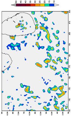

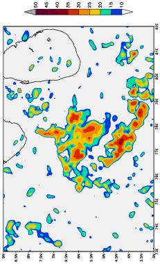


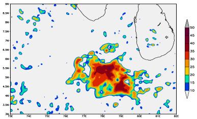


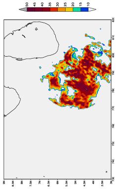

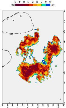

5 Test with Single Shipboard Doppler Radar Data (continued) 03 HR 06 HR 09 HR 12 HR CNTL FCST = 00 HR OBS (Vr+Z) Vr Composite radar refrectivity (dbz) Valid at 18:00 UTC 14 Oct. 21:00 UTC 14 Oct. 00:00 UTC 15 Oct. 03:00 UTC 15 Oct. 06:00 UTC 15 Oct.


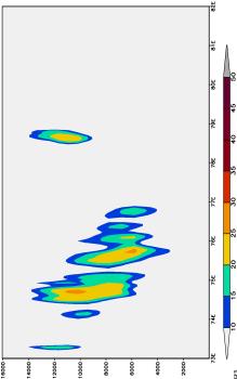
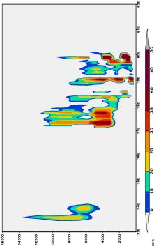


6 (Vr+Z) Vr CNTL Test with Single Shipboard Doppler Radar Data (continued) FCST = 00 HR 03 HR 06 HR 09 HR 12 HR Valid at 18:00 UTC 14 Oct. 21:00 UTC 14 Oct. 00:00 UTC 15 Oct. 03:00 UTC 15 Oct. 06:00 UTC 15 Oct. Radar refrectivity (dbz)
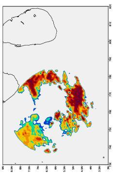
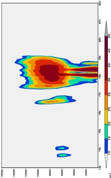
 at FCST=3H Observed CNTL (dbz) Vr (Vr+Z) (dbz) The control forecast basically")
 in storm")


7 Test with Single Shipboard Doppler Radar Data (continued) Upward Motion (contours, ms -1 ) at FCST=3H Observed CNTL (dbz) Vr (Vr+Z) (dbz) The control forecast basically missed the storms because it missed the upward motion in the storm areas. V r DA increases the upward motion at middle and upper levels (above ~4km) in storm areas, with max upward velocity of ~0.8 ms -1 at ~7km. This is more conducive dynamics for intensification. The combined (V r +Z) DA improves upward motion at all vertical levels inside the storms with the max upward velocity of ~1.2 ms -1 near the storm base; again conducive for providing sufficient moisture and energy for storm development. (dbz) (dbz)
.")
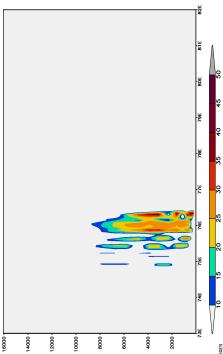
 DA increases the moisture both below and above the storm base for the improved storm.")
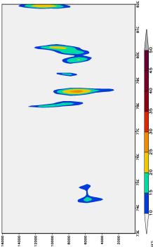
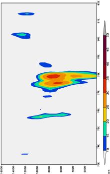
8 Test with Single Shipboard Doppler Radar Data (continued) Increments (EXP-CNTL) of q v (colored areas, g kg -1 ) and T (contours, K) at FCST=3H Vr (Vr+Z) q v >0, T>0 Increased water vapor and condensation due to the increased upward motion q v >0, T<0 Increased evaporation from precipitation of the improved storm V r DA increases moisture below the storm base (~2km). This could be from the increased evaporation of precipitation from the improved storm above. The negative temperature change in that area shows the cooling effect of the precipitation evaporation. The combined (V r +Z) DA increases the moisture both below and above the storm base for the improved storm. The positive temperature change above ~2km shows the increased condensation due to the increased moisture that aids the storm development.
9 Equitable Threat Score Test with Single Shipboard Doppler Radar Data (continued) Equitable Threat Score Equitable Threat Score Equitable Threat Scores of Storm Forecasts (measured by radar reflectivity) from CNTL, Vr, and (Vr+Z) CNTL Vr (Vr+Z) dbz 15 dbz dbz Forecast hours Forecast hours Forecast hours HWDDC data assimilation improved both storm location and intensity forecasts

 every 12 hours along with conventional and satellite data over the 6-day")
")
10 Test with WSR-88D Radar Data 1-hr window for radar data 6-hr window for conventional & satellite data 12Z 22 June 00Z 23 June 12Z 23 June 00Z 24 June 12Z 24 June 00Z 25 June 12Z 25 June 00Z 26 June 12Z 26 June 00Z 27 June 12Z 27 June 45-km 5 km Level-II Vr and Z data from 22 WSR-88D radars were collected and assimilated to all model grids (5-km, 15-km, 45-km) every 12 hours along with conventional and satellite data over the 6-day period Model forecasts from the three experiments were verified against sounding profiles over the model domains 15 km Three experiments: CNTL Conventional+Satellite Vr Conventional+Satellite+Vr (Vr+Z) Conventional+Satellite+Vr+Z
 CNTL Vr (Vr+Z) 14.")
 RMS Error - U (ms -1 ) RMS Error - V (ms -1 ) RMS Error - q")


11 Test with WSR-88D Radar Data (continued) 6-day (23-27 June) Average RMS Errors of 48h-Forecasts Verified Against Sounding OBS (15km grid) CNTL Vr (Vr+Z) 14.0% 13.7% 13.0% 14.8% RMS Error - T (k) RMS Error - U (ms -1 ) RMS Error - V (ms -1 ) RMS Error - q v (gkg -1 ) Both Vr and (Vr+Z) data assimilations reduced the forecast errors of model state variables at most vertical levels. The reductions in model forecast errors mainly improve the large-scale environment for storm development. The improvement was basically attributed to Vr DA impact. Radar reflectivity (Z) DA did not add additional value to the large-scale environment forecast.
 2.5 2 1.8 6.6% 2 8.3% CNTL Vr (Vr+Z) 1.5 0 12 24 36 48 60 72 Forecast lead-time (hour) 6.5 1.")
 0 12 24 36 48 60 72 Forecast lead-time (hour) Radar data assimilation impact lasted for more than 72 hours for most state variables. 5.")
12 RMS Error - U (ms -1 ) RMS Error - T (K) RMS Error - V (ms -1 ) RMS Error - q v (gkg -1 ) Test with WSR-88D Radar Data (continued) 6-day (23-27 June) Average RMS Errors (15km grid, averaged over the 3D domain) % 2 8.3% CNTL Vr (Vr+Z) Forecast lead-time (hour) CNTL Vr (Vr+Z) Forecast lead-time (hour) Radar data assimilation impact lasted for more than 72 hours for most state variables % 12.7% CNTL Vr (Vr+Z) CNTL Vr (Vr+Z) Forecast lead-time (hour) Forecast lead-time (hour)
13 Conclusions Radar data assimilation improves storm forecasts for both locations and intensity Single shipboard Doppler radar data showed notable impact on improving storm prediction for more than 12 hours In regions where conventional meteorological data are limited, radar observations of storms are critical in storm forecast Vr data showed improved storm structures mainly at middle and upper levels, while Z data showed impact at lower levels While both Vr and Z improve storm structures, Vr data assimilation also enhance the mesoscale and large-scale environment for storm development Enlarged radar data coverage and cycled data assimilation are the key factors in extending the data assimilation impact from hours to days

14 Marine Meteorology Division, Monterey, California Thank you
3.23 IMPROVING VERY-SHORT-TERM STORM PREDICTIONS BY ASSIMILATING RADAR AND SATELLITE DATA INTO A MESOSCALE NWP MODEL
 3.23 IMPROVING VERY-SHORT-TERM STORM PREDICTIONS BY ASSIMILATING RADAR AND SATELLITE DATA INTO A MESOSCALE NWP MODEL Q. Zhao 1*, J. Cook 1, Q. Xu 2, and P. Harasti 3 1 Naval Research Laboratory, Monterey,
Ensemble Assimilation of Nonconventional Observations for Nowcasting
 DISTRIBUTION STATEMENT A. Approved for public release; distribution is unlimited. Ensemble Assimilation of Nonconventional Observations for Nowcasting Allen Zhao Marine Meteorological Division, Naval Research
Improved Doppler Radar/Satellite Data Assimilation
 Improved Doppler Radar/Satellite Data Assimilation Allen Zhao Marine Meteorological Division, Naval Research Laboratory 7 Grace Hopper Ave, Mail Stop II, Monterey, CA 93943-5502 Phone: (831) 656-4700 fax:
Improved EM Tactical Applications through UAS-Enhanced High-Resolution Mesoscale Data Assimilation and Modeling
 DISTRIBUTION STATEMENT A. Approved for public release; distribution is unlimited. Improved EM Tactical Applications through UAS-Enhanced High-Resolution Mesoscale Data Assimilation and Modeling Teddy R.
COUPLED OCEAN-ATMOSPHERE 4DVAR
 COUPLED OCEAN-ATMOSPHERE 4DVAR Hans Ngodock, Matthew Carrier, Clark Rowley, Tim Campbell NRL, Stennis Space Center Clark Amerault, Liang Xu, Teddy Holt NRL, Monterey 11/17/2016 International workshop on
Research and Development of Advanced Radar Data Quality Control and Assimilation for Nowcasting and Forecasting Severe Storms
 DISTRIBUTION STATEMENT A. Approved for public release; distribution is unlimited. Research and Development of Advanced Radar Data Quality Control and Assimilation for Nowcasting and Forecasting Severe
13A.5 A New Method for Compressing Quality-Controlled Weather Radar Data by Exploiting Blankout Markers Due to Thresholding Operations
 13A.5 A New Method for Compressing Quality-Controlled Weather Radar Data by Exploiting Blankout Markers Due to Thresholding Operations W. David Pan Dept. of Electrical & Computer Engineering, University
Deterministic and Ensemble Storm scale Lightning Data Assimilation
 LI Mission Advisory Group & GOES-R Science Team Workshop 27-29 May 2015 Deterministic and Ensemble Storm scale Lightning Data Assimilation Don MacGorman, Ted Mansell (NOAA/National Severe Storms Lab) Alex
Radar Data Quality Control and Assimilation at the National Weather Radar Testbed (NWRT)
") Radar Data Quality Control and Assimilation at the National Weather Radar Testbed (NWRT) Dr. Qin Xu CIMMS, University of Oklahoma, 100 E. Boyd (Rm 1110), Norman, OK 73019 phone: (405) 325-3041 fax: (405)
Radar Data Quality Control and Assimilation at the National Weather Radar Testbed (NWRT) Dr. Qin Xu CIMMS, University of Oklahoma, 100 E. Boyd (Rm 1110), Norman, OK 73019 phone: (405) 325-3041 fax: (405)
Looking Hurricanes in the Eye
 Looking Hurricanes in the Eye If we could better understand the role of aerosols, in particular manmade ones, in tropical cyclone (TC) formation and intensity, we could better numerically model and forecast
COMPOSITE-BASED VERIFICATION OF PRECIPITATION FORECASTS FROM A MESOSCALE MODEL
 J13.5 COMPOSITE-BASED VERIFICATION OF PRECIPITATION FORECASTS FROM A MESOSCALE MODEL Jason E. Nachamkin, Sue Chen, and Jerome M. Schmidt Naval Research Laboratory, Monterey, CA 1. INTRODUCTION Mesoscale
Impact of METOP ASCAT Ocean Surface Winds in the NCEP GDAS/GFS and NRL NAVDAS
 Impact of METOP ASCAT Ocean Surface Winds in the NCEP GDAS/GFS and NRL NAVDAS COAMPS @ Li Bi 1,2 James Jung 3,4 Michael Morgan 5 John F. Le Marshall 6 Nancy Baker 2 Dave Santek 3 1 University Corporation
Development of a Mesoscale Ensemble Data Assimilation System at the Naval Research Laboratory
 1322 W E A T H E R A N D F O R E C A S T I N G VOLUME 28 Development of a Mesoscale Ensemble Data Assimilation System at the Naval Research Laboratory QINGYUN ZHAO Marine Meteorology Division, Naval Research
Jidong Gao and David Stensrud. NOAA/National Severe Storm Laboratory Norman, Oklahoma
 Assimilation of Reflectivity and Radial Velocity in a Convective-Scale, Cycled 3DVAR Framework with Hydrometeor Classification Jidong Gao and David Stensrud NOAA/National Severe Storm Laboratory Norman,
14.4 ON THE DEVELOPMENT OF A WEATHER RADAR DATA ASSIMILATION SYSTEM FOR THE US NAVY
 14.4 ON THE DEVELOPMENT OF A WEATHER RADAR DATA ASSIMILATION SYSTEM FOR THE US NAVY Paul R. Harasti Visiting Scientist Programs, University Corporation for Atmospheric Research, Boulder, Colorado W. David
Estimating Observation Impact with the NAVDAS Adjoint System
 Estimating Observation Impact with the NAVDAS Adjoint System Rolf Langland, Nancy Baker Marine Meteorology Division Naval Research Laboratory (NRL) Monterey, CA USA Talk presented by Ronald Errico 1 Terminology
12B.5 AT-SEA DEMONSTRATION OF THE SPS-48E RADAR WEATHER EXTRACTION CAPABILITY
 12B.5 AT-SEA DEMONSTRATION OF THE SPS-48E RADAR WEATHER EXTRACTION CAPABILITY Paul R. Harasti Visiting Scientist Programs, University Corporation for Atmospheric Research, Boulder, CO, USA Michael Frost,
Satellite Assimilation Activities for the NRL Atmospheric Variational Data Assimilation (NAVDAS) and NAVDAS- AR (Accelerated Representer) Systems
 and NAVDAS- AR (Accelerated Representer) Systems") Satellite Assimilation Activities for the NRL Atmospheric Variational Data Assimilation (NAVDAS) and NAVDAS- AR (Accelerated Representer) Systems Marine Meteorology Division, NRL Monterey Nancy Baker,
Satellite Assimilation Activities for the NRL Atmospheric Variational Data Assimilation (NAVDAS) and NAVDAS- AR (Accelerated Representer) Systems Marine Meteorology Division, NRL Monterey Nancy Baker,
Error Covariance Estimation and Representation for Mesoscale Data Assimilation
 Error Covariance Estimation and Representation for Mesoscale Data Assimilation Dr. Qin Xu CIMMS, University of Oklahoma, 100 E. Boyd (Rm 1110), Norman, OK 73019 phone: (405) 325-3041 fax: (405) 325-7614
The Properties of Convective Clouds Over the Western Pacific and Their Relationship to the Environment of Tropical Cyclones
 The Properties of Convective Clouds Over the Western Pacific and Their Relationship to the Environment of Tropical Cyclones Principal Investigator: Dr. Zhaoxia Pu Department of Meteorology, University
P1.10 Synchronization of Multiple Radar Observations in 3-D Radar Mosaic
 Submitted for the 12 th Conf. on Aviation, Range, and Aerospace Meteor. 29 Jan. 2 Feb. 2006. Atlanta, GA. P1.10 Synchronization of Multiple Radar Observations in 3-D Radar Mosaic Hongping Yang 1, Jian
COAMPS-TC 2015 Version, Performance, and Future Plans
 COAMPS-TC 2015 Version, Performance, and Future Plans James D. Doyle, R. Hodur 1, J. Moskaitis, S. Chen, E. Hendricks 2, H. Jin, Y. Jin, A. Reinecke, S. Wang Naval Research Laboratory, Monterey, CA 1 IES/SAIC,
Convective-scale Warn-on-Forecast The Future of Severe Weather Warnings in the USA?
 Convective-scale Warn-on-Forecast The Future of Severe Weather Warnings in the USA? David J. Stensrud Department of Meteorology The Pennsylvania State University Present Warning System: 2 March 2012 Warning
The Properties of Convective Clouds over the Western Pacific and Their Relationship to the Environment of Tropical Cyclones
 DISTRIBUTION STATEMENT A. Approved for public release; distribution is unlimited. The Properties of Convective Clouds over the Western Pacific and Their Relationship to the Environment of Tropical Cyclones
4D-Var Data Assimilation for Navy Mesoscale NWP
 DISTRIBUTION STATEMENT A. Approved for public release; distribution is unlimited. 4D-Var Data Assimilation for Navy Mesoscale NWP Liang Xu Naval Research Laboratory Monterey, CA 93943-5502 phone: (831)
Chengsi Liu 1, Ming Xue 1, 2, Youngsun Jung 1, Lianglv Chen 3, Rong Kong 1 and Jingyao Luo 3 ISDA 2019
 Development of Optimized Radar Data Assimilation Capability within the Fully Coupled EnKF EnVar Hybrid System for Convective Permitting Ensemble Forecasting and Testing via NOAA Hazardous Weather Testbed
Some Applications of WRF/DART
 Some Applications of WRF/DART Chris Snyder, National Center for Atmospheric Research Mesoscale and Microscale Meteorology Division (MMM), and Institue for Mathematics Applied to Geoscience (IMAGe) WRF/DART
Myung-Sook Park, Russell L. Elsberry and Michael M. Bell. Department of Meteorology, Naval Postgraduate School, Monterey, California, USA
 Latent heating rate profiles at different tropical cyclone stages during 2008 Tropical Cyclone Structure experiment: Comparison of ELDORA and TRMM PR retrievals Myung-Sook Park, Russell L. Elsberry and
Thunderstorm-Scale EnKF Analyses Verified with Dual-Polarization, Dual-Doppler Radar Data
 Thunderstorm-Scale EnKF Analyses Verified with Dual-Polarization, Dual-Doppler Radar Data David Dowell and Wiebke Deierling National Center for Atmospheric Research, Boulder, CO Ensemble Data Assimilation
Masahiro Kazumori, Takashi Kadowaki Numerical Prediction Division Japan Meteorological Agency
 Development of an all-sky assimilation of microwave imager and sounder radiances for the Japan Meteorological Agency global numerical weather prediction system Masahiro Kazumori, Takashi Kadowaki Numerical
The Nowcasting Demonstration Project for London 2012
 The Nowcasting Demonstration Project for London 2012 Susan Ballard, Zhihong Li, David Simonin, Jean-Francois Caron, Brian Golding, Met Office, UK Introduction The success of convective-scale NWP is largely
Assimilation of Satellite Infrared Brightness Temperatures and Doppler Radar Observations in a High-Resolution OSSE
 Assimilation of Satellite Infrared Brightness Temperatures and Doppler Radar Observations in a High-Resolution OSSE Jason Otkin and Becky Cintineo University of Wisconsin-Madison, Cooperative Institute
13A. 4 Analysis and Impact of Super-obbed Doppler Radial Velocity in the NCEP Grid-point Statistical Interpolation (GSI) Analysis System
 Analysis System") 13A. 4 Analysis and Impact of Super-obbed Doppler Radial Velocity in the NCEP Grid-point Statistical Interpolation (GSI) Analysis System Shun Liu 1, Ming Xue 1,2, Jidong Gao 1,2 and David Parrish 3 1 Center
13A. 4 Analysis and Impact of Super-obbed Doppler Radial Velocity in the NCEP Grid-point Statistical Interpolation (GSI) Analysis System Shun Liu 1, Ming Xue 1,2, Jidong Gao 1,2 and David Parrish 3 1 Center
Improving Surface Flux Parameterizations in the NRL Coupled Ocean/Atmosphere Mesoscale Prediction System
 Improving Surface Flux Parameterizations in the NRL Coupled Ocean/Atmosphere Mesoscale Prediction System LONG-TERM GOAL Shouping Wang Naval Research Laboratory Monterey, CA 93943 Phone: (831) 656-4719
University of Oklahoma, Norman Oklahoma Monthly Weather Review Submitted June 2017 Accepted November 2017
 Development of a Hybrid En3DVar Data Assimilation System and Comparisons with 3DVar and EnKF for Radar Data Assimilation with Observing System Simulation Experiments Rong Kong 1,2, Ming Xue 1,2, and Chengsi
P1.6 Simulation of the impact of new aircraft and satellite-based ocean surface wind measurements on H*Wind analyses
 P1.6 Simulation of the impact of new aircraft and satellite-based ocean surface wind measurements on H*Wind analyses Timothy L. Miller 1, R. Atlas 2, P. G. Black 3, J. L. Case 4, S. S. Chen 5, R. E. Hood
Xiaodong Hong 1*, James Doyle 1, Richard M. Hodur 1, and Paul J. Martin 2
 4.5 APPLICATION OF COAMPS TM OCEAN DATA ASSIMILATIONS IN THE AOSN II MONTEREY BAY Xiaodong Hong 1*, James Doyle 1, Richard M. Hodur 1, and Paul J. Martin 2 1 Naval Research Laboratory, Monterey, CA 93943
Recent COAMPS-TC Development and Future Plans
 Recent COAMPS-TC Development and Future Plans James D. Doyle, Jon Moskaitis, Rich Hodur1, Sue Chen, Hao Jin, Yi Jin, Will Komaromi, Alex Reinecke, David Ryglicki, Dan Stern2, Shouping Wang Naval Research
Implementation of Modeling the Land-Surface/Atmosphere Interactions to Mesoscale Model COAMPS
 DISTRIBUTION STATEMENT A. Approved for public release; distribution is unlimited. Implementation of Modeling the Land-Surface/Atmosphere Interactions to Mesoscale Model COAMPS Dr. Bogumil Jakubiak Interdisciplinary
Multi-scale Predictability Aspects of a Severe European Winter Storm
 1 Multi-scale Predictability Aspects of a Severe European Winter Storm NASA MODIS James D. Doyle, C. Amerault, P. A. Reinecke, C. Reynolds Naval Research Laboratory, Monterey, CA Mesoscale Predictability
DISTRIBUTION STATEMENT A: Approved for public release; distribution is unlimited.
 DISTRIBUTION STATEMENT A: Approved for public release; distribution is unlimited. Prediction and Predictability of Tropical Cyclones over Oceanic and Coastal Regions and Advanced Assimilation of Radar
THE IMPACT OF GROUND-BASED GPS SLANT-PATH WET DELAY MEASUREMENTS ON SHORT-RANGE PREDICTION OF A PREFRONTAL SQUALL LINE
 JP1.17 THE IMPACT OF GROUND-BASED GPS SLANT-PATH WET DELAY MEASUREMENTS ON SHORT-RANGE PREDICTION OF A PREFRONTAL SQUALL LINE So-Young Ha *1,, Ying-Hwa Kuo 1, Gyu-Ho Lim 1 National Center for Atmospheric
Radar Data Quality Control and Assimilation at the National Weather Radar Testbed (NWRT)
") Radar Data Quality Control and ssimilation at the National Weather Radar Testbed (NWRT) Qin Xu CIMMS, University of Oklahoma, 120 David L. Boren Blvd., Norman, OK 73072 phone: (405) 325-3041 fax: (405)
Radar Data Quality Control and ssimilation at the National Weather Radar Testbed (NWRT) Qin Xu CIMMS, University of Oklahoma, 120 David L. Boren Blvd., Norman, OK 73072 phone: (405) 325-3041 fax: (405)
Enhancing information transfer from observations to unobserved state variables for mesoscale radar data assimilation
 Enhancing information transfer from observations to unobserved state variables for mesoscale radar data assimilation Weiguang Chang and Isztar Zawadzki Department of Atmospheric and Oceanic Sciences Faculty
Assimilation of Himawari-8 Atmospheric Motion Vectors into the Numerical Weather Prediction Systems of Japan Meteorological Agency
 Assimilation of Himawari-8 Atmospheric Motion Vectors into the Numerical Weather Prediction Systems of Japan Meteorological Agency Koji Yamashita Japan Meteorological Agency kobo.yamashita@met.kishou.go.jp,
AN OBSERVING SYSTEM EXPERIMENT OF MTSAT RAPID SCAN AMV USING JMA MESO-SCALE OPERATIONAL NWP SYSTEM
 AN OBSERVING SYSTEM EXPERIMENT OF MTSAT RAPID SCAN AMV USING JMA MESO-SCALE OPERATIONAL NWP SYSTEM Koji Yamashita Japan Meteorological Agency / Numerical Prediction Division 1-3-4, Otemachi, Chiyoda-ku,
9D.3 THE INFLUENCE OF VERTICAL WIND SHEAR ON DEEP CONVECTION IN THE TROPICS
 9D.3 THE INFLUENCE OF VERTICAL WIND SHEAR ON DEEP CONVECTION IN THE TROPICS Ulrike Wissmeier, Robert Goler University of Munich, Germany 1 Introduction One does not associate severe storms with the tropics
Impact of Assimilating Airborne Doppler Radar Velocity Data Using the ARPS 3DVAR on the Analysis and Prediction of Hurricane Ike (2008)
") 1 2 3 4 5 6 7 8 9 10 11 12 13 14 15 16 17 18 19 20 21 22 23 24 25 26 27 28 29 30 31 32 33 34 35 36 37 38 Impact of Assimilating Airborne Doppler Radar Velocity Data Using the ARPS 3DVAR on the Analysis
1 2 3 4 5 6 7 8 9 10 11 12 13 14 15 16 17 18 19 20 21 22 23 24 25 26 27 28 29 30 31 32 33 34 35 36 37 38 Impact of Assimilating Airborne Doppler Radar Velocity Data Using the ARPS 3DVAR on the Analysis
Aircraft-based Observations: Impact on weather forecast model performance
 Aircraft-based Observations: Impact on weather forecast model performance Stephen S. Weygandt Eric James, Stan Benjamin, Bill Moninger, Brian Jamison, Geoff Manikin* NOAA Earth System Research Laboratory
Module 11: Meteorology Topic 5 Content: Weather Maps Notes
 Introduction A variety of weather maps are produced by the National Weather Service and National Oceanographic Atmospheric Administration. These maps are used to help meteorologists accurately predict
Tropical Cyclone Intensity and Structure Changes in relation to Tropical Cyclone Outflow
 DISTRIBUTION STATEMENT A. Approved for public release; distribution is unlimited. Tropical Cyclone Intensity and Structure Changes in relation to Tropical Cyclone Outflow Patrick A. Harr Department of
Tropical Cyclone Initialization with Dynamical and Physical constraints derived from Satellite data
 International Workshop on Rapid Change Phenomena in Tropical Cyclones Haikou China, 5 9 November 2012 Tropical Cyclone Initialization with Dynamical and Physical constraints derived from Satellite data
Daniel T. Dawson II* 1,2, Ming Xue 1,2, Jason A. Milbrandt 2, M. K. Yau 3, and Guifu Zhang 2
 Preprints, 22th Conf. on Weather Analysis and Forecasting and 18th Conf. on Numerical Weather Prediction Amer. Meteor. Soc., Park City, UT, 25-29 June 2007 10B.2 IMPACT OF MULTI-MOMENT MICROPHYSICS AND
13.2 IMPACT OF CONFIGURATIONS OF RAPID INTERMITTENT ASSIMILATION OF WSR-88D RADAR DATA FOR THE 8 MAY 2003 OKLAHOMA CITY TORNADIC THUNDERSTORM CASE
 13.2 IMPACT OF CONFIGURATIONS OF RAPID INTERMITTENT ASSIMILATION OF WSR-D RADAR DATA FOR THE MAY 23 OKLAHOMA CITY TORNADIC THUNDERSTORM CASE Ming Hu and Ming Xue* Center for Analysis and Prediction of
Development and Research of GSI-based EnVar System to Assimilate Radar Observations for Convective Scale Analysis and Forecast
 Development and Research of GSI-based EnVar System to Assimilate Radar Observations for Convective Scale Analysis and Forecast Xuguang Wang, Yongming Wang School of Meteorology University of Oklahoma,
Precipitation Structure and Processes of Typhoon Nari (2001): A Modeling Propsective
: A Modeling Propsective") Precipitation Structure and Processes of Typhoon Nari (2001): A Modeling Propsective Ming-Jen Yang Institute of Hydrological Sciences, National Central University 1. Introduction Typhoon Nari (2001) struck
Precipitation Structure and Processes of Typhoon Nari (2001): A Modeling Propsective Ming-Jen Yang Institute of Hydrological Sciences, National Central University 1. Introduction Typhoon Nari (2001) struck
Implementation and Evaluation of WSR-88D Reflectivity Data Assimilation for WRF-ARW via GSI and Cloud Analysis. Ming Hu University of Oklahoma
 Implementation and Evaluation of WSR-88D Reflectivity Data Assimilation for WRF-ARW via GSI and Cloud Analysis Ming Hu University of Oklahoma 1. Previous work and Goal of visiting Previous work: Radar
2012 and changes to the Rapid Refresh and HRRR weather forecast models
 2012 and 2013-15 changes to the Rapid Refresh and HRRR weather forecast models 31 October 2012 Stan Benjamin Steve Weygandt Curtis Alexander NOAA Earth System Research Laboratory Boulder, CO FPAW - 2012
THE IMPACT OF DIFFERENT DATA FIELDS ON STORM-SSCALE DATA ASSIMILATION
 JP1J.3 THE IMPACT OF DIFFERENT DATA FIELDS ON STORM-SSCALE DATA ASSIMILATION Guoqing Ge 1,2,*, Jidong Gao 1, Kelvin Droegemeier 1,2 Center for Analysis and Prediction of Storms, University of Oklahoma,
Diagnosing the Intercept Parameter for Exponential Raindrop Size Distribution Based on Video Disdrometer Observations: Model Development
 Diagnosing the Intercept Parameter for Exponential Raindrop Size Distribution Based on Video Disdrometer Observations: Model Development Guifu Zhang 1, Ming Xue 1,2, Qing Cao 1 and Daniel Dawson 1,2 1
Single-Doppler EnKF assimilation of high-resolution data from the 29 May 2004 OKC supercell: Comparisons with dual-doppler analyses.
 Single-Doppler assimilation of high-resolution data from the 29 May 2004 OKC supercell: Comparisons with dual-doppler analyses. Lou Wicker NOAA/National Severe Storms Lab, Norman OK With lots of help from:
NAVAL RESEARCH LABORATORY. Recent Developments in NWP
 NAVAL RESEARCH LABORATORY Recent Developments in NWP Carolyn Reynolds, Nancy Baker, James Doyle, Douglas Westphal, Melinda Peng Marine Meteorology Division, Simon Chang, Director Naval Research Laboratory,
Ensemble Kalman Filter Assimilation of Radar Data for a Convective Storm using a Two-moment Microphysics Scheme 04/09/10
 Ensemble Kalman Filter Assimilation of Radar Data for a Convective Storm using a Two-moment Microphysics Scheme 04/09/10 Youngsun Jung 1, Ming Xue 1,2, and Mingjing Tong 3 CAPS 1 and School of Meteorology
Impact of ATOVS data in a mesoscale assimilationforecast system over the Indian region
 Impact of ATOVS data in a mesoscale assimilationforecast system over the Indian region John P. George and Munmun Das Gupta National Centre for Medium Range Weather Forecasting, Department of Science &
ABSTRACT 3 RADIAL VELOCITY ASSIMILATION IN BJRUC 3.1 ASSIMILATION STRATEGY OF RADIAL
 REAL-TIME RADAR RADIAL VELOCITY ASSIMILATION EXPERIMENTS IN A PRE-OPERATIONAL FRAMEWORK IN NORTH CHINA Min Chen 1 Ming-xuan Chen 1 Shui-yong Fan 1 Hong-li Wang 2 Jenny Sun 2 1 Institute of Urban Meteorology,
Radar Data Quality Control and Assimilation at the National Weather Radar Testbed (NWRT)
") Radar Data Quality Control and ssimilation at the National Weather Radar Testbed (NWRT) Dr. Qin Xu CIMMS, University of Oklahoma 120 David L. Boren Blvd., Suite 2100 Norman, OK 73072-730 phone: (405) 325-3041
Radar Data Quality Control and ssimilation at the National Weather Radar Testbed (NWRT) Dr. Qin Xu CIMMS, University of Oklahoma 120 David L. Boren Blvd., Suite 2100 Norman, OK 73072-730 phone: (405) 325-3041
Anisotropic spatial filter that is based on flow-dependent background error structures is implemented and tested.
 Special Topics 3DVAR Analysis/Retrieval of 3D water vapor from GPS slant water data Liu, H. and M. Xue, 2004: 3DVAR retrieval of 3D moisture field from slant-path water vapor observations of a high-resolution
A Seasonal Statistical Evaluation of COAMPS Ò over the Arabian Gulf Region
 Pure appl. geophys. 164 (2007) 1747 1764 0033 4553/07/091747 18 DOI 10.1007/s00024-007-0229-0 Ó Birkhäuser Verlag, Basel, 2007 Pure and Applied Geophysics A Seasonal Statistical Evaluation of COAMPS Ò
4.5 A WRF-DART study of the nontornadic and tornadic supercells intercepted by VORTEX2 on 10 June 2010
 4.5 A WRF-DART study of the nontornadic and tornadic supercells intercepted by VORTEX2 on 10 June 2010 ALICIA M. KLEES AND YVETTE P. RICHARDSON The Pennsylvania State University, University Park, Pennsylvania.
Implementation and Evaluation of WSR-88D Radial Velocity Data Assimilation for WRF-NMM via GSI
 Implementation and Evaluation of WSR-88D Radial Velocity Data Assimilation for WRF-NMM via GSI Shun Liu 1, Ming Xue 1,2 1 Center for Analysis and Prediction of Storms and 2 School of Meteorology University
Interaction in Precipitation
 UCRL-JC-128781 PREPRINT Interaction in Precipitation a California Event Martin J Leach Jun Kong This paper was prepared for submittal to the 78th American Meteorological Society Annual Meeting 16th Conference
Impact of Resolution on Extended-Range Multi-Scale Simulations
 DISTRIBUTION STATEMENT A. Approved for public release; distribution is unlimited. Impact of Resolution on Extended-Range Multi-Scale Simulations Carolyn A. Reynolds Naval Research Laboratory Monterey,
Operationally Relevant 4D Refractivity
 DISTRIBUTION STATEMENT A. Approved for public release; distribution is unlimited. Operationally Relevant 4D Refractivity Tracy Haack Naval Research Laboratory, Marine Meteorology Division Monterey, CA
6.3 SEA BREEZE CIRCULATIONS INFLUENCING RADIO FREQUENCY SYSTEM PERFORMANCE AROUND CALIFORNIA BAJA SUR
 6.3 SEA BREEZE CIRCULATIONS INFLUENCING RADIO FREQUENCY SYSTEM PERFORMANCE AROUND CALIFORNIA BAJA SUR 1. INTRODUCTION Robert E. Marshall * Naval Surface Warfare Center, Dahlgren, Virginia Non-standard
P7.1 STUDY ON THE OPTIMAL SCANNING STRATEGIES OF PHASE-ARRAY RADAR THROUGH ENSEMBLE KALMAN FILTER ASSIMILATION OF SIMULATED DATA
 P7.1 STUDY ON THE OPTIMAL SCANNING STRATEGIES OF PHASE-ARRAY RADAR THROUGH ENSEMBLE KALMAN FILTER ASSIMILATION OF SIMULATED DATA Ting Lei 1, Ming Xue 1,, Tianyou Yu 3 and Michihiro Teshiba 3 1 Center for
Parameterization of Cumulus Convective Cloud Systems in Mesoscale Forecast Models
 DISTRIBUTION STATEMENT A. Approved for public release; distribution is unlimited. Parameterization of Cumulus Convective Cloud Systems in Mesoscale Forecast Models Yefim L. Kogan Cooperative Institute
Ensemble-Based Data Assimilation of GPM/DP R Reflectivity into the Nonhydrostatic Icosahed ral Atmospheric Model NICAM
 Ensemble-Based Data Assimilation of GPM/DP R Reflectivity into the Nonhydrostatic Icosahed ral Atmospheric Model NICAM Shunji Kotsuki1, Koji Terasaki1, Shigenori Otsuka1, Kenta Kurosawa1, and Takemasa
PUBLICATIONS. Journal of Geophysical Research: Atmospheres
 PUBLICATIONS Journal of Geophysical Research: Atmospheres RESEARCH ARTICLE Key Points: T-TREC-retrieved wind and radial velocity data are assimilated using an ensemble Kalman filter The relative impacts
Evaluation and assimilation of all-sky infrared radiances of Himawari-8
 Evaluation and assimilation of all-sky infrared radiances of Himawari-8 Kozo Okamoto 1,2, Yohei Sawada 1,2, Masaru Kunii 1, Tempei Hashino 3, Takeshi Iriguchi 1 and Masayuki Nakagawa 1 1: JMA/MRI, 2: RIKEN/AICS,
Severe Weather Simulation Experiment (QuickOSSE) Using Super Constellations of GNSS Radio Occultation Satellites
 Using Super Constellations of GNSS Radio Occultation Satellites") Severe Weather Simulation Experiment (QuickOSSE) Using Super Constellations of GNSS Radio Occultation Satellites S. Mark Leidner 1, Thomas Nehrkorn 1, John Henderson 1, Marikate Mountain 1, Tom Yunck 2
Severe Weather Simulation Experiment (QuickOSSE) Using Super Constellations of GNSS Radio Occultation Satellites S. Mark Leidner 1, Thomas Nehrkorn 1, John Henderson 1, Marikate Mountain 1, Tom Yunck 2
IMPACT OF DIFFERENT MICROPHYSICS SCHEMES AND ADDITIONAL SURFACE OBSERVATIONS ON NEWS-E FORECASTS
 IMPACT OF DIFFERENT MICROPHYSICS SCHEMES AND ADDITIONAL SURFACE OBSERVATIONS ON NEWS-E FORECASTS Francesca M. Lappin 1, Dustan M. Wheatley 2,3, Kent H. Knopfmeier 2,3, and Patrick S. Skinner 2,3 1 National
Real-Time Meteorological Battlespace Characterization in Support of Sea Power 21
 Real-Time Meteorological Battlespace Characterization in Support of Sea Power 21 John Cook Naval Research Laboratory Marine Meteorology Division 7 Grace Hopper Avenue Monterey, CA 93943-5502 phone: (831)
Global and Regional OSEs at JMA
 Global and Regional OSEs at JMA Yoshiaki SATO and colleagues Japan Meteorological Agency / Numerical Prediction Division 1 JMA NWP SYSTEM Global OSEs Contents AMSU A over coast, MHS over land, (related
The Influence of Atmosphere-Ocean Interaction on MJO Development and Propagation
 DISTRIBUTION STATEMENT A. Approved for public release; distribution is unlimited. The Influence of Atmosphere-Ocean Interaction on MJO Development and Propagation PI: Sue Chen Naval Research Laboratory
P5.7 MERGING AMSR-E HYDROMETEOR DATA WITH COASTAL RADAR DATA FOR SHORT TERM HIGH-RESOLUTION FORECASTS OF HURRICANE IVAN
 14th Conference on Satellite Meteorology and Oceanography Atlanta, GA, January 30-February 2, 2006 P5.7 MERGING AMSR-E HYDROMETEOR DATA WITH COASTAL RADAR DATA FOR SHORT TERM HIGH-RESOLUTION FORECASTS
The Impacts of GPSRO Data Assimilation and Four Ices Microphysics Scheme on Simulation of heavy rainfall Events over Taiwan during June 2012
 The Impacts of GPSRO Data Assimilation and Four Ices Microphysics Scheme on Simulation of heavy rainfall Events over Taiwan during 10-12 June 2012 Pay-Liam LIN, Y.-J. Chen, B.-Y. Lu, C.-K. WANG, C.-S.
Assimilate W88D Doppler Vr for Humberto 05
 Assimilate W88D Doppler Vr for Humberto 05 WRF/EnKF Forecast vs. Observations vs. 3DVAR Min SLP Max wind The WRF/3DVAR (as a surrogate of operational algorithm) assimilates the same radar data but without
Quantifying Uncertainty through Global and Mesoscale Ensembles
 Quantifying Uncertainty through Global and Mesoscale Ensembles Teddy R. Holt Naval Research Laboratory Monterey CA 93943-5502 phone: (831) 656-4740 fax: (831) 656-4769 e-mail: holt@nrlmry.navy.mil Award
A new mesoscale NWP system for Australia
 A new mesoscale NWP system for Australia www.cawcr.gov.au Peter Steinle on behalf of : Earth System Modelling (ESM) and Weather&Environmental Prediction (WEP) Research Programs, CAWCR Data Assimilation
FAA Weather Research Plans
 FAA Weather Research Plans Presented to: Friends /Partners in Aviation Weather Vision Forum By: Ray Moy FAA Aviation Weather Office Date: Aviation Weather Research Program (AWRP) Purpose: Applied Research
Fleet Numerical Meteorology and Oceanography Center. Current Sub-seasonal to Seasonal Capabilities
 Fleet Numerical Meteorology and Oceanography Center Current Sub-seasonal to Seasonal Capabilities presented at Workshop on Metrics, Post-Processing, and Products for S2S 28 Feb 2018 Chuck Skupniewicz Modeling
Meteorological Studies with the Phased Array Weather Radar and Data Assimilation Using the Ensemble Kalman Filter
 Meteorological Studies with the Phased Array Weather Radar and Data Assimilation Using the Ensemble Kalman Filter Tian-You Yu University of Oklahoma, 202 West Boyd, rm 427, Norman, OK 73019 phone: (405)
Simulating the formation of Hurricane Katrina (2005)
") GEOPHYSICAL RESEARCH LETTERS, VOL. 35, L11802, doi:10.1029/2008gl033168, 2008 Simulating the formation of Hurricane Katrina (2005) Yi Jin, 1 Melinda S. Peng, 1 and Hao Jin 2 Received 2 January 2008; revised
GEOPHYSICAL RESEARCH LETTERS, VOL. 35, L11802, doi:10.1029/2008gl033168, 2008 Simulating the formation of Hurricane Katrina (2005) Yi Jin, 1 Melinda S. Peng, 1 and Hao Jin 2 Received 2 January 2008; revised
A Pilot Program to Examine High-Resolution Modeling of Coastal Land-Air-Sea Interaction in the Monterey Bay
 DISTRIBUTION STATEMENT A. Approved for public release; distribution is unlimited. A Pilot Program to Examine High-Resolution Modeling of Coastal Land-Air-Sea Interaction in the Monterey Bay James D. Doyle
Adaptive Radar Data Quality Control and Ensemble-Based Assimilation for Analyzing and Forecasting High-Impact Weather
 DISTRIBUTION STATEMENT A: Approved for public release; distribution is unlimited. Adaptive Radar Data Quality Control and Ensemble-Based Assimilation for Analyzing and Forecasting High-Impact Weather Qin
Impact of Assimilating Radar Radial Wind in the Canadian High Resolution
 Impact of Assimilating Radar Radial Wind in the Canadian High Resolution 12B.5 Ensemble Kalman Filter System Kao-Shen Chung 1,2, Weiguang Chang 1, Luc Fillion 1,2, Seung-Jong Baek 1,2 1 Department of Atmospheric
A Cycled GSI+EnKF and Storm-Scale Ensemble Forecasting (SSEF) Experiment
 Experiment") A Cycled GSI+EnKF and Storm-Scale Ensemble Forecasting (SSEF) Experiment Fanyou Kong, Ming Xue, Youngsun Jung, Keith A. Brewster, Gang Zhao Center for Analysis and Prediction of Storms University of Oklahoma
A Cycled GSI+EnKF and Storm-Scale Ensemble Forecasting (SSEF) Experiment Fanyou Kong, Ming Xue, Youngsun Jung, Keith A. Brewster, Gang Zhao Center for Analysis and Prediction of Storms University of Oklahoma
Impact of Configurations of Rapid Intermittent Assimilation of WSR-88D Radar Data for the 8 May 2003 Oklahoma City Tornadic Thunderstorm Case
 FEBRUARY 2007 H U A N D X U E 507 Impact of Configurations of Rapid Intermittent Assimilation of WSR-88D Radar Data for the 8 May 2003 Oklahoma City Tornadic Thunderstorm Case MING HU AND MING XUE Center
Multiple-Radar Data Assimilation and Short-Range Quantitative Precipitation Forecasting of a Squall Line Observed during IHOP_2002
 OCTOBER 2007 X I A O A N D S U N 3381 Multiple-Radar Data Assimilation and Short-Range Quantitative Precipitation Forecasting of a Squall Line Observed during IHOP_2002 QINGNONG XIAO AND JUANZHEN SUN Mesoscale
Coupled Global-Regional Data Assimilation Using Joint States
 DISTRIBUTION STATEMENT A. Approved for public release; distribution is unlimited. Coupled Global-Regional Data Assimilation Using Joint States Istvan Szunyogh Texas A&M University, Department of Atmospheric