A new mesoscale NWP system for Australia
|
|
|
- Emma Skinner
- 5 years ago
- Views:
Transcription


1 A new mesoscale NWP system for Australia Peter Steinle on behalf of : Earth System Modelling (ESM) and Weather&Environmental Prediction (WEP) Research Programs, CAWCR Data Assimilation Team Leader July 2012
2 NWP environment Met Office Unified Model UM 7.5 / L70 Global N320 (~40km) 4dVAR 6 hourly 4dVAR Global, Region 4km City Systems (UM7.6) No Assimilation Grey zone 1.5km (UM7.6) 3dVAR + radar winds & precip (LHN) Relocatable Transition to operations Regional 0.11 o 4dVAR Ensembles? Global & Regional EPS Research only Need deterministic high res.
3 Issues Radar data & NWP Historically distinct Compare NWP fields & radar data (precip & winds) Convection permitting resolutions Configure and test model away from the UK Feasible within Bureau resources Objective use of radar data Data quality & error characteristics Value & quality of clear air echoes? Development of a suitable NWP system Assimilation of precipitation data & Doppler radial winds Limitations of Aust observing network etc. Evaluation of NWP system
4 Experimental 1.5km system Aim for system capable of using radar data 3dVAR (3 hourly initially) Move to Hourly Latent Heat nudging Doppler radial winds Best coverage is over Eastern NSW (Sydney Domain) Covariances from 12km system Main focus so far Radar & QPE quality control Errors in radar QC introduce spurious rainfall patterns Doppler radial wind QC precip & clear air echoes Assessing model performance Configuring 3dVAR and Latent Heat Nudging (ongoing)


5 Systematic errors in radar rain estimates Clutter Blocking from hills Gauge climatology Radar clutter rejection Radar climatology


6 Cleaning up the radar data Detect anomalous propagation & clutter 3d structure of texture

7 Doppler wind processing De-aliasing algorithms are being implemented in the quality control ACCESS-A / radial wind usually within ±2 m s -1 and ±20º. Bias is small. Continue investigation of insect winds in NWP.
8 Quality of Clear Air Winds - birds and bees? Birds are not OK Insects are OK

9 Assimilation of clear air wind


10 Target area? High population Best observing system Radar & surface Susceptible to severe weather Heavy rains, storms etc. Sydney & Eastern NSW
11 Fractions Skill Score (Sep2011-Feb2012) 70+ days : 02Z, 05Z, 08Z 23Z 5 hour forecasts 1.5km+3dVAR+LHN ACCESS-A 12km ACCESS-SY 0.05 o (APS0) ACCESS-SY 4km (APS1) 1mm/hr 2mm/hr 4mm/hr 8mm/hr
12 Model Issues: Distribution of rainfall intensity Too much convection & too strong Obs 3dVAR+LHN 3dVAR only
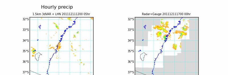
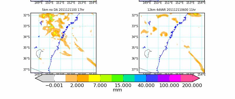
13 Example
14 Value-added by Latent Heat Nudging over 3dVAR Adds value for a few hours only Increases Prob. of Detection & decreases False Alarm Ratio Latent Heat Nudging + 3dVAR 3dVAR only Modifications required reduce nudging strength rel. to UK Limit size of increments Possible reasons: Different atmospheric environment (shear) Lag in cloud formation & preciptation vs effect of nudging No cloud analysis in Aus
15 Where are we? 1.5km + 3dVAR +LHN improves short range hourly precip forecasts Resolution matters (both for UM & VAR: 1.5km vs 12km) Latent heat nudging adds value for ~6 hours Better at spinning up some weak precipitation than heavy precip Cloud nudging for deep convection? Have improved QC of radar reflectivity Doppler winds seem OK so far Clear air winds comparisons encouraging
16 So where to? Address model issues Cloud & Rainfall processes Too many intense cells, too little light rain Too much frozen water in 1.5km clouds Improved lateral boundary conditions Stretched grid & Improved large scale systems Assimilation Doppler winds Hourly DA Gravity wave noise due to DA seems insignificant >> Forecasters VERY interested in hourly high-res analyses that use all data << How will forecasters use this???

17 1.5km vs ACCESS-A: 10m wind speed 00Z to 09Z

18 1.5km vs ACCESS-A: screen dewpoint 00Z to 09Z

19 1.5km vs ACCESS-A: screen temperature 00Z to 09Z
20 Summary 1.5km system is very encouraging Latent Heat nudging seems to only provide value for a few hours Hourly 3dVAR is our preferred strategy at the moment Need to improve microphysical processes And various other aspects of NWP Forecasters have been very quick to see the potential value

21 Thank you Peter Steinle Data Assimilation Team Leader Earth System Modelling Research Program Phone: Web:
Observing System Impact Studies in ACCESS
 Observing System Impact Studies in ACCESS www.cawcr.gov.au Chris Tingwell, Peter Steinle, John le Marshall, Elaine Miles, Yi Xiao, Rolf Seecamp, Jin Lee, Susan Rennie, Xingbao Wang, Justin Peter, Alan
Advances in weather modelling
 Advances in weather modelling www.cawcr.gov.au Robert Fawcett - speaking on behalf of CAWCR Earth-System Modelling and CAWCR Weather and Environmental Prediction May 2013 The Centre for Australian Weather
Assimilation of Doppler radar observations for high-resolution numerical weather prediction
 Assimilation of Doppler radar observations for high-resolution numerical weather prediction Susan Rennie, Peter Steinle, Mark Curtis, Yi Xiao, Alan Seed Introduction Numerical Weather Prediction (NWP)
Convective-scale NWP for Singapore
 Convective-scale NWP for Singapore Hans Huang and the weather modelling and prediction section MSS, Singapore Dale Barker and the SINGV team Met Office, Exeter, UK ECMWF Symposium on Dynamical Meteorology
The Nowcasting Demonstration Project for London 2012
 The Nowcasting Demonstration Project for London 2012 Susan Ballard, Zhihong Li, David Simonin, Jean-Francois Caron, Brian Golding, Met Office, UK Introduction The success of convective-scale NWP is largely
Met Office convective-scale 4DVAR system, tests and improvement
 Met Office convective-scale 4DVAR system, tests and improvement Marco Milan*, Marek Wlasak, Stefano Migliorini, Bruce Macpherson Acknowledgment: Inverarity Gordon, Gareth Dow, Mike Thurlow, Mike Cullen
BARRA: A high-resolution atmospheric reanalysis over Australia for
 BARRA: A high-resolution atmospheric reanalysis over Australia for 1990-2016 Chun-Hsu Su, Australian Bureau of Meteorology N. Eizenberg 1, G. Kuciuba 1, P. Steinle 1, D. Jakob 1, P. Fox-Hughes 1, R. Renshaw
Convective-scale data assimilation at the UK Met Office
 Convective-scale data assimilation at the UK Met Office DAOS meeting, Exeter 25 April 2016 Rick Rawlins Hd(DAE) Acknowledgments: Bruce Macpherson and team Contents This presentation covers the following
Deterministic and Ensemble Storm scale Lightning Data Assimilation
 LI Mission Advisory Group & GOES-R Science Team Workshop 27-29 May 2015 Deterministic and Ensemble Storm scale Lightning Data Assimilation Don MacGorman, Ted Mansell (NOAA/National Severe Storms Lab) Alex
0-6 hour Weather Forecast Guidance at The Weather Company. Steven Honey, Joseph Koval, Cathryn Meyer, Peter Neilley The Weather Company
 1 0-6 hour Weather Forecast Guidance at The Weather Company Steven Honey, Joseph Koval, Cathryn Meyer, Peter Neilley The Weather Company TWC Forecasts: Widespread Adoption 2 0-6 Hour Forecast Details 3
Scatterometer Wind Assimilation at the Met Office
 Scatterometer Wind Assimilation at the Met Office James Cotton International Ocean Vector Winds Science Team (IOVWST) meeting, Brest, June 2014 Outline Assimilation status Global updates: Metop-B and spatial
Enhancing information transfer from observations to unobserved state variables for mesoscale radar data assimilation
 Enhancing information transfer from observations to unobserved state variables for mesoscale radar data assimilation Weiguang Chang and Isztar Zawadzki Department of Atmospheric and Oceanic Sciences Faculty
Doppler radial wind spatially correlated observation error: operational implementation and initial results
 Doppler radial wind spatially correlated observation error: operational implementation and initial results D. Simonin, J. Waller, G. Kelly, S. Ballard,, S. Dance, N. Nichols (Met Office, University of
Some Applications of WRF/DART
 Some Applications of WRF/DART Chris Snyder, National Center for Atmospheric Research Mesoscale and Microscale Meteorology Division (MMM), and Institue for Mathematics Applied to Geoscience (IMAGe) WRF/DART
SERIES A DYNAMIC METEOROLOGY AND OCEANOGRAPHY
 PUBLISHED BY THE INTERNATIONAL METEOROLOGICAL INSTITUTE IN STOCKHOLM SERIES A DYNAMIC METEOROLOGY AND OCEANOGRAPHY Tellus (2011), 63A, 468 496 Printed in Singapore. All rights reserved C 2011 The Met Office
Assimilation of satellite derived soil moisture for weather forecasting
 Assimilation of satellite derived soil moisture for weather forecasting www.cawcr.gov.au Imtiaz Dharssi and Peter Steinle February 2011 SMOS/SMAP workshop, Monash University Summary In preparation of the
Chengsi Liu 1, Ming Xue 1, 2, Youngsun Jung 1, Lianglv Chen 3, Rong Kong 1 and Jingyao Luo 3 ISDA 2019
 Development of Optimized Radar Data Assimilation Capability within the Fully Coupled EnKF EnVar Hybrid System for Convective Permitting Ensemble Forecasting and Testing via NOAA Hazardous Weather Testbed
Using time-lag ensemble techniques to assess behaviour of high-resolution precipitation forecasts
 Using time-lag ensemble techniques to assess behaviour of high-resolution precipitation forecasts Marion Mittermaier 3 rd Int l Verification Methods Workshop, ECMWF, 31/01/2007 Crown copyright Page 1 Outline
REQUIREMENTS FOR WEATHER RADAR DATA. Review of the current and likely future hydrological requirements for Weather Radar data
 WORLD METEOROLOGICAL ORGANIZATION COMMISSION FOR BASIC SYSTEMS OPEN PROGRAMME AREA GROUP ON INTEGRATED OBSERVING SYSTEMS WORKSHOP ON RADAR DATA EXCHANGE EXETER, UK, 24-26 APRIL 2013 CBS/OPAG-IOS/WxR_EXCHANGE/2.3
A 21st century HRRR-based approach to estimating probable maximum precipitation to enhance dam safety and community resilience
 30 May 2017 FIRO Science Task Group Workshop A 21st century HRRR-based approach to estimating probable maximum precipitation to enhance dam safety and community resilience Courtesy Bill McCormick, Chief,
Nowcasting techniques in use for severe weather operation in NMC/CMA
 WWRP NMRWG Buenos Aires Aug 2017 Nowcasting techniques in use for severe weather operation in NMC/CMA Jianjie WANG National Meteorological Center, CMA Cascading Weather Forecasting Process --- different
Convective Scale Data Assimilation and Nowcasting
 Convective Scale Data Assimilation and Nowcasting ECMWF Seminars 2011 Susan P Ballard, David Simonin, Zhihong Li, Jean-Francois Caron, Lee Hawkness-Smith, Cristina Charlton-Perez, Helen Buttery, Nicolas
Activity Report for Australian TCWCs 2009/2012
 Activity Report for Australian TCWCs 2009/2012 7th RSMC/TCWC Co-ordination Meeting Citeko, November 2012 Mike Bergin Regional Director (Western Australia) Bureau of Meteorology Outline Significant Cyclones
Operational Use of Scatterometer Winds in the JMA Data Assimilation System
 Operational Use of Scatterometer Winds in the Data Assimilation System Masaya Takahashi Numerical Prediction Division, Japan Meteorological Agency () International Ocean Vector Winds Science Team Meeting,
Verification of ensemble and probability forecasts
 Verification of ensemble and probability forecasts Barbara Brown NCAR, USA bgb@ucar.edu Collaborators: Tara Jensen (NCAR), Eric Gilleland (NCAR), Ed Tollerud (NOAA/ESRL), Beth Ebert (CAWCR), Laurence Wilson
Feature-specific verification of ensemble forecasts
 Feature-specific verification of ensemble forecasts www.cawcr.gov.au Beth Ebert CAWCR Weather & Environmental Prediction Group Uncertainty information in forecasting For high impact events, forecasters
Strategic Radar Enhancement Project (SREP) Forecast Demonstration Project (FDP) The future is here and now
 Forecast Demonstration Project (FDP) The future is here and now") Strategic Radar Enhancement Project (SREP) Forecast Demonstration Project (FDP) The future is here and now Michael Berechree National Manager Aviation Weather Services Australian Bureau of Meteorology
Strategic Radar Enhancement Project (SREP) Forecast Demonstration Project (FDP) The future is here and now Michael Berechree National Manager Aviation Weather Services Australian Bureau of Meteorology
Thunderstorm-Scale EnKF Analyses Verified with Dual-Polarization, Dual-Doppler Radar Data
 Thunderstorm-Scale EnKF Analyses Verified with Dual-Polarization, Dual-Doppler Radar Data David Dowell and Wiebke Deierling National Center for Atmospheric Research, Boulder, CO Ensemble Data Assimilation
Variational data assimilation of lightning with WRFDA system using nonlinear observation operators
 Variational data assimilation of lightning with WRFDA system using nonlinear observation operators Virginia Tech, Blacksburg, Virginia Florida State University, Tallahassee, Florida rstefane@vt.edu, inavon@fsu.edu
QPE and QPF in the Bureau of Meteorology
 QPE and QPF in the Bureau of Meteorology Current and future real-time rainfall products Carlos Velasco (BoM) Alan Seed (BoM) and Luigi Renzullo (CSIRO) OzEWEX 2016, 14-15 December 2016, Canberra Why do
Assimilate W88D Doppler Vr for Humberto 05
 Assimilate W88D Doppler Vr for Humberto 05 WRF/EnKF Forecast vs. Observations vs. 3DVAR Min SLP Max wind The WRF/3DVAR (as a surrogate of operational algorithm) assimilates the same radar data but without
Utilising Radar and Satellite Based Nowcasting Tools for Aviation Purposes in South Africa. Erik Becker
 Utilising Radar and Satellite Based Nowcasting Tools for Aviation Purposes in South Africa Erik Becker Morné Gijben, Mary-Jane Bopape, Stephanie Landman South African Weather Service: Nowcasting and Very
ABSTRACT 3 RADIAL VELOCITY ASSIMILATION IN BJRUC 3.1 ASSIMILATION STRATEGY OF RADIAL
 REAL-TIME RADAR RADIAL VELOCITY ASSIMILATION EXPERIMENTS IN A PRE-OPERATIONAL FRAMEWORK IN NORTH CHINA Min Chen 1 Ming-xuan Chen 1 Shui-yong Fan 1 Hong-li Wang 2 Jenny Sun 2 1 Institute of Urban Meteorology,
WIND PROFILER NETWORK OF JAPAN METEOROLOGICAL AGENCY
 WIND PROFILER NETWORK OF JAPAN METEOROLOGICAL AGENCY Masahito Ishihara Japan Meteorological Agency CIMO Expert Team on Remote Sensing Upper-Air Technology and Techniques 14-17 March, 2005 Geneva, Switzerland
3.23 IMPROVING VERY-SHORT-TERM STORM PREDICTIONS BY ASSIMILATING RADAR AND SATELLITE DATA INTO A MESOSCALE NWP MODEL
 3.23 IMPROVING VERY-SHORT-TERM STORM PREDICTIONS BY ASSIMILATING RADAR AND SATELLITE DATA INTO A MESOSCALE NWP MODEL Q. Zhao 1*, J. Cook 1, Q. Xu 2, and P. Harasti 3 1 Naval Research Laboratory, Monterey,
Tangent-linear and adjoint models in data assimilation
 Tangent-linear and adjoint models in data assimilation Marta Janisková and Philippe Lopez ECMWF Thanks to: F. Váňa, M.Fielding 2018 Annual Seminar: Earth system assimilation 10-13 September 2018 Tangent-linear
Current Limited Area Applications
 Current Limited Area Applications Nils Gustafsson SMHI Norrköping, Sweden nils.gustafsson@smhi.se Outline of talk (contributions from many HIRLAM staff members) Specific problems of Limited Area Model
Current and future configurations of MOGREPS-UK. Susanna Hagelin EWGLAM/SRNWP, Rome, 4 Oct 2016
 Current and future configurations of MOGREPS-UK Susanna Hagelin EWGLAM/SRNWP, Rome, 4 Oct 2016 Contents Current configuration PS38 and package trial results Soil moisture perturbations case study Future
Concepts of Forecast Verification FROST-14
 Concepts of Forecast Verification FROST-14 Forecast & Research Olympics Sochi Testbed Pertti Nurmi WWRP JWGFVR Finnish Meteorological Institute pertti.nurmi@fmi.fi pertti.nurmi@fmi.fi FROST-14 Verification
Predicting rainfall using ensemble forecasts
 Predicting rainfall using ensemble forecasts Nigel Roberts Met Office @ Reading MOGREPS-UK Convection-permitting 2.2 km ensemble now running routinely Embedded within MOGREPS-R ensemble members (18 km)
Validation of operational NWP forecasts for global, diffuse and direct solar exposure over Australia
 Validation of operational NWP forecasts for global, diffuse and direct solar exposure over Australia www.bom.gov.au Lawrie Rikus, Paul Gregory, Zhian Sun, Tomas Glowacki Bureau of Meteorology Research
Radius of reliability: A distance metric for interpreting and verifying spatial probability forecasts
 Radius of reliability: A distance metric for interpreting and verifying spatial probability forecasts Beth Ebert CAWCR, Bureau of Meteorology Melbourne, Australia Introduction Wish to warn for high impact
Application and verification of ECMWF products 2015
 Application and verification of ECMWF products 2015 Instituto Português do Mar e da Atmosfera, I.P. 1. Summary of major highlights At Instituto Português do Mar e da Atmosfera (IPMA) ECMWF products are
WG1 Overview. PP KENDA for km-scale EPS: LETKF. current DA method: nudging. radar reflectivity (precip): latent heat nudging 1DVar (comparison)
: latent heat nudging 1DVar (comparison)") WG1 Overview Deutscher Wetterdienst, D-63067 Offenbach, Germany current DA method: nudging PP KENDA for km-scale EPS: LETKF radar reflectivity (precip): latent heat nudging 1DVar (comparison) radar radial
WG1 Overview Deutscher Wetterdienst, D-63067 Offenbach, Germany current DA method: nudging PP KENDA for km-scale EPS: LETKF radar reflectivity (precip): latent heat nudging 1DVar (comparison) radar radial
Progress in NWP on Intel HPC architecture at Australian Bureau of Meteorology
 Progress in NWP on Intel HPC architecture at Australian Bureau of Meteorology www.cawcr.gov.au Robin Bowen Senior ITO Earth System Modelling Programme 04 October 2012 ECMWF HPC Presentation outline Weather
Convective-Scale Data Assimilation
 Convective-Scale Data Assimilation Dale Barker, with contributions from Met Office colleagues, and: Jelena Bolarova (HIRLAM), Yann Michel (Meteo France), Luc Fillion (Environment Canada), Kazuo Saito (JMA/MRI)
JP1J.9 ASSIMILATION OF RADAR DATA IN THE MET OFFICE MESOSCALE AND CONVECTIVE SCALE FORECAST SYSTEMS
 JP1J.9 ASSIMILATION OF RADAR DATA IN THE MET OFFICE MESOSCALE AND CONVECTIVE SCALE FORECAST SYSTEMS S. Ballard *, M. Dixon, S. Swarbrick,, Z. Li,, O.Stiller, H. Lean, F. Rihan 2 and C.Collier 2 Met Office
Operational Use of Scatterometer Winds at JMA
 Operational Use of Scatterometer Winds at JMA Masaya Takahashi Numerical Prediction Division, Japan Meteorological Agency (JMA) 10 th International Winds Workshop, Tokyo, 26 February 2010 JMA Outline JMA
Flood Forecasting with Radar
 Flood Forecasting with Radar Miguel Angel Rico-Ramirez m.a.rico-ramirez@bristol.ac.uk Encuentro Internacional de Manejo del Riesgo por Inundaciones, UNAM, 22 th Jan 2013 Talk Outline Rainfall estimation
Spatial methods for assessing radar data assimilation performance at RHM: a framework
 Spatial methods for assessing radar data assimilation performance at RHM: a framework A. Bundel, A. Muraviev, D. Blinov, E. Finkelberg COSMO General Meeting, Jerusalem, Israel 10 September 2017 C C 5 4.5
On the use of radar rainfall estimates and nowcasts in an operational heavy rainfall warning service
 On the use of radar rainfall estimates and nowcasts in an operational heavy rainfall warning service Alan Seed, Ross Bunn, Aurora Bell Bureau of Meteorology Australia The Centre for Australian Weather
Aircraft-based Observations: Impact on weather forecast model performance
 Aircraft-based Observations: Impact on weather forecast model performance Stephen S. Weygandt Eric James, Stan Benjamin, Bill Moninger, Brian Jamison, Geoff Manikin* NOAA Earth System Research Laboratory
Meteorology 311. RADAR Fall 2016
 Meteorology 311 RADAR Fall 2016 What is it? RADAR RAdio Detection And Ranging Transmits electromagnetic pulses toward target. Tranmission rate is around 100 s pulses per second (318-1304 Hz). Short silent
Merging Rain-Gauge and Radar Data
 Merging Rain-Gauge and Radar Data Dr Sharon Jewell, Obserations R&D, Met Office, FitzRoy Road, Exeter sharon.jewell@metoffice.gov.uk Outline 1. Introduction The Gauge and radar network Interpolation techniques
Grid point spacing (km) T2047 H K T7999 NH M
 T2047 H K T7999 NH M") (Very) High Res NWP ECMWF High-resolution modelling developments (inputs: Nils Wedi, Mats Hamrud, George Mozdzynski, Jean Bidlot, Geir Austad, Sinisa Curic ) Current and planned resolutions: IFS model
(Very) High Res NWP ECMWF High-resolution modelling developments (inputs: Nils Wedi, Mats Hamrud, George Mozdzynski, Jean Bidlot, Geir Austad, Sinisa Curic ) Current and planned resolutions: IFS model
Nesting and LBCs, Predictability and EPS
 Nesting and LBCs, Predictability and EPS Terry Davies, Dynamics Research, Met Office Nigel Richards, Neill Bowler, Peter Clark, Caroline Jones, Humphrey Lean, Ken Mylne, Changgui Wang copyright Met Office
Global Flash Flood Forecasting from the ECMWF Ensemble
 Global Flash Flood Forecasting from the ECMWF Ensemble Calumn Baugh, Toni Jurlina, Christel Prudhomme, Florian Pappenberger calum.baugh@ecmwf.int ECMWF February 14, 2018 Building a Global FF System 1.
Progress in Latent Heat Nudging Real Case Studies
 Progress in Latent Heat Nudging Real Case Studies RADVOR-OP, supported by LAWA Stefan Klink FE 12 Data Assimilation stefan.klink@dwd.de 24.09.2003-1 - Progress in Latent Heat Nudging Real Case Studies
JP1.15 PHYSICAL INITIALIZATION TO INCORPORATE RADAR PRECIPITATION DATA INTO A NUMERICAL WEATHER PREDICTION MODEL (Lokal Model)
") JP1.15 PHYSICAL INITIALIZATION TO INCORPORATE RADAR PRECIPITATION DATA INTO A NUMERICAL WEATHER PREDICTION MODEL (Lokal Model) M. Milan 1, F. Ament 1, V. Venema 1, A. Battaglia 1, C. Simmer 1 1 Meteorological
JP1.15 PHYSICAL INITIALIZATION TO INCORPORATE RADAR PRECIPITATION DATA INTO A NUMERICAL WEATHER PREDICTION MODEL (Lokal Model) M. Milan 1, F. Ament 1, V. Venema 1, A. Battaglia 1, C. Simmer 1 1 Meteorological
Radar data assimilation using a modular programming approach with the Ensemble Kalman Filter: preliminary results
 Radar data assimilation using a modular programming approach with the Ensemble Kalman Filter: preliminary results I. Maiello 1, L. Delle Monache 2, G. Romine 2, E. Picciotti 3, F.S. Marzano 4, R. Ferretti
Generating probabilistic forecasts from convectionpermitting. Nigel Roberts
 Generating probabilistic forecasts from convectionpermitting ensembles Nigel Roberts Context for this talk This is the age of the convection-permitting model ensemble Met Office: MOGREPS-UK UK 2.2km /12
Verifying Ensemble Forecasts Using A Neighborhood Approach
 Verifying Ensemble Forecasts Using A Neighborhood Approach Craig Schwartz NCAR/MMM schwartz@ucar.edu Thanks to: Jack Kain, Ming Xue, Steve Weiss Theory, Motivation, and Review Traditional Deterministic
Multi Radar Multi Sensor NextGen Weather Program. Presentation materials sourced from: Ken Howard HydroMet Research Group NSSL Warning R&D Division
 Multi Radar Multi Sensor NextGen Weather Program Presentation materials sourced from: Ken Howard HydroMet Research Group NSSL Warning R&D Division What is Multiple Radar Multi Sensor System () is the world
1. Current atmospheric DA systems 2. Coupling surface/atmospheric DA 3. Trends & ideas
 1 Current issues in atmospheric data assimilation and its relationship with surfaces François Bouttier GAME/CNRM Météo-France 2nd workshop on remote sensing and modeling of surface properties, Toulouse,
Diabatic processes and the structure of extratropical cyclones
 Geophysical and Nonlinear Fluid Dynamics Seminar AOPP, Oxford, 23 October 2012 Diabatic processes and the structure of extratropical cyclones Oscar Martínez-Alvarado R. Plant, J. Chagnon, S. Gray, J. Methven
Assimilation of Airborne Doppler Radar Observations Using the Unified GSI based Hybrid Ensemble Variational Data Assimilation System for HWRF
 Assimilation of Airborne Doppler Radar Observations Using the Unified GSI based Hybrid Ensemble Variational Data Assimilation System for HWRF Xuguang Wang xuguang.wang@ou.edu University of Oklahoma, Norman,
THE IMPACT OF DIFFERENT DATA FIELDS ON STORM-SSCALE DATA ASSIMILATION
 JP1J.3 THE IMPACT OF DIFFERENT DATA FIELDS ON STORM-SSCALE DATA ASSIMILATION Guoqing Ge 1,2,*, Jidong Gao 1, Kelvin Droegemeier 1,2 Center for Analysis and Prediction of Storms, University of Oklahoma,
Aurora Bell*, Alan Seed, Ross Bunn, Bureau of Meteorology, Melbourne, Australia
 15B.1 RADAR RAINFALL ESTIMATES AND NOWCASTS: THE CHALLENGING ROAD FROM RESEARCH TO WARNINGS Aurora Bell*, Alan Seed, Ross Bunn, Bureau of Meteorology, Melbourne, Australia 1. Introduction Warnings are
Assimilation of Satellite Infrared Brightness Temperatures and Doppler Radar Observations in a High-Resolution OSSE
 Assimilation of Satellite Infrared Brightness Temperatures and Doppler Radar Observations in a High-Resolution OSSE Jason Otkin and Becky Cintineo University of Wisconsin-Madison, Cooperative Institute
AROME Nowcasting - tool based on a convective scale operational system
 AROME Nowcasting - tool based on a convective scale operational system RC - LACE stay report Supervisors (ZAMG): Yong Wang Florian Meier Christoph Wittmann Author: Mirela Pietrisi (NMA) 1. Introduction
Radars, Hydrology and Uncertainty
 Radars, Hydrology and Uncertainty Francesca Cecinati University of Bristol, Department of Civil Engineering francesca.cecinati@bristol.ac.uk Supervisor: Miguel A. Rico-Ramirez Research objectives Study
Convective-scale Warn-on-Forecast The Future of Severe Weather Warnings in the USA?
 Convective-scale Warn-on-Forecast The Future of Severe Weather Warnings in the USA? David J. Stensrud Department of Meteorology The Pennsylvania State University Present Warning System: 2 March 2012 Warning
Introduction to Data Assimilation
 Introduction to Data Assimilation Alan O Neill Data Assimilation Research Centre University of Reading What is data assimilation? Data assimilation is the technique whereby observational data are combined
Application and verification of ECMWF products 2009
 Application and verification of ECMWF products 2009 Hungarian Meteorological Service 1. Summary of major highlights The objective verification of ECMWF forecasts have been continued on all the time ranges
Ting Lei, Xuguang Wang University of Oklahoma, Norman, OK, USA. Wang and Lei, MWR, Daryl Kleist (NCEP): dual resolution 4DEnsVar
: dual resolution 4DEnsVar") GSI-based four dimensional ensemble-variational (4DEnsVar) data assimilation: formulation and single resolution experiments with real data for NCEP GFS Ting Lei, Xuguang Wang University of Oklahoma, Norman,
GSI-based four dimensional ensemble-variational (4DEnsVar) data assimilation: formulation and single resolution experiments with real data for NCEP GFS Ting Lei, Xuguang Wang University of Oklahoma, Norman,
C. Gebhardt, S. Theis, R. Kohlhepp, E. Machulskaya, M. Buchhold. developers of KENDA, ICON-EPS, ICON-EDA, COSMO-D2, verification
 Convective-scale EPS at DWD status, developments & plans C. Gebhardt, S. Theis, R. Kohlhepp, E. Machulskaya, M. Buchhold developers of KENDA, ICON-EPS, ICON-EDA, COSMO-D2, verification 1 Outline new operational
Implementation and Evaluation of WSR-88D Radial Velocity Data Assimilation for WRF-NMM via GSI
 Implementation and Evaluation of WSR-88D Radial Velocity Data Assimilation for WRF-NMM via GSI Shun Liu 1, Ming Xue 1,2 1 Center for Analysis and Prediction of Storms and 2 School of Meteorology University
2012 and changes to the Rapid Refresh and HRRR weather forecast models
 2012 and 2013-15 changes to the Rapid Refresh and HRRR weather forecast models 31 October 2012 Stan Benjamin Steve Weygandt Curtis Alexander NOAA Earth System Research Laboratory Boulder, CO FPAW - 2012
Convective Scale Data Assimilation and Nowcasting
 Convective Scale Data Assimilation and Nowcasting Susan P Ballard 1, Bruce Macpherson 2, Zhihong Li 1, David Simonin 1, Jean-Francois Caron 1, Helen Buttery 1, Cristina Charlton-Perez 1, Nicolas Gaussiat
Jidong Gao and David Stensrud. NOAA/National Severe Storm Laboratory Norman, Oklahoma
 Assimilation of Reflectivity and Radial Velocity in a Convective-Scale, Cycled 3DVAR Framework with Hydrometeor Classification Jidong Gao and David Stensrud NOAA/National Severe Storm Laboratory Norman,
The development of a Kriging based Gauge and Radar merged product for real-time rainfall accumulation estimation
 The development of a Kriging based Gauge and Radar merged product for real-time rainfall accumulation estimation Sharon Jewell and Katie Norman Met Office, FitzRoy Road, Exeter, UK (Dated: 16th July 2014)
Recent Data Assimilation Activities at Environment Canada
 Recent Data Assimilation Activities at Environment Canada Major upgrade to global and regional deterministic prediction systems (now in parallel run) Sea ice data assimilation Mark Buehner Data Assimilation
Recent progress in convective scale Arome NWP system and on-going research activities
 Recent progress in convective scale Arome NWP system and on-going research activities P. Brousseau, P. Chambon, G. Faure, R. Honnert, A. Mary, N. Merlet, Y. Seity, B. Vié, E. Wattrelot (presented by F.
Di Wu, Xiquan Dong, Baike Xi, Zhe Feng, Aaron Kennedy, and Gretchen Mullendore. University of North Dakota
 Di Wu, Xiquan Dong, Baike Xi, Zhe Feng, Aaron Kennedy, and Gretchen Mullendore University of North Dakota Objectives 3 case studies to evaluate WRF and NAM performance in Oklahoma (OK) during summer 2007,
Assessing the spatial and temporal variation in the skill of precipitation forecasts from an NWP model
 METEOROLOGICAL APPLICATIONS Meteorol. Appl. 15: 163 169 (2008) Published online in Wiley InterScience (www.interscience.wiley.com).57 Assessing the spatial and temporal variation in the skill of precipitation
4DEnVar. Four-Dimensional Ensemble-Variational Data Assimilation. Colloque National sur l'assimilation de données
 Four-Dimensional Ensemble-Variational Data Assimilation 4DEnVar Colloque National sur l'assimilation de données Andrew Lorenc, Toulouse France. 1-3 décembre 2014 Crown copyright Met Office 4DEnVar: Topics
HIGH SPATIAL AND TEMPORAL RESOLUTION ATMOSPHERIC MOTION VECTORS GENERATION, ERROR CHARACTERIZATION AND ASSIMILATION
 HIGH SPATIAL AND TEMPORAL RESOLUTION ATMOSPHERIC MOTION VECTORS GENERATION, ERROR CHARACTERIZATION AND ASSIMILATION John Le Marshall Director, JCSDA 2004-2007 CAWCR 2007-2010 John Le Marshall 1,2, Rolf
Tropical cyclone simulations and predictions with GFDL s prototype global cloud resolving model
 Tropical cyclone simulations and predictions with GFDL s prototype global cloud resolving model S.-J. Lin and GFDL model development teams NOAA/Geophysical Fluid Dynamics Laboratory Workshop on High-Resolution
Assimilation of radar reflectivity
 Assimilation of radar reflectivity Axel Seifert Deutscher Wetterdienst, Offenbach, Germany Convective-scale NWP at DWD: Plans for 2020 Storm-scale ICON-RUC-EPS: hourly 12h ensemble forecasts based on short
EWGLAM/SRNWP National presentation from DMI
 EWGLAM/SRNWP 2013 National presentation from DMI Development of operational Harmonie at DMI Since Jan 2013 DMI updated HARMONIE-Denmark suite to CY37h1 with a 3h-RUC cycling and 57h forecast, 8 times a
Retrospective and near real-time tests of GSIbased EnKF-Var hybrid data assimilation system for HWRF with airborne radar data
 Retrospective and near real-time tests of GSIbased EnKF-Var hybrid data assimilation system for HWRF with airborne radar data Xuguang Wang, Xu Lu, Yongzuo Li University of Oklahoma, Norman, OK In collaboration
The Impact of Horizontal Resolution and Ensemble Size on Probabilistic Forecasts of Precipitation by the ECMWF EPS
 The Impact of Horizontal Resolution and Ensemble Size on Probabilistic Forecasts of Precipitation by the ECMWF EPS S. L. Mullen Univ. of Arizona R. Buizza ECMWF University of Wisconsin Predictability Workshop,
GL Garrad Hassan Short term power forecasts for large offshore wind turbine arrays
 GL Garrad Hassan Short term power forecasts for large offshore wind turbine arrays Require accurate wind (and hence power) forecasts for 4, 24 and 48 hours in the future for trading purposes. Receive 4
Spatial verification of NWP model fields. Beth Ebert BMRC, Australia
 Spatial verification of NWP model fields Beth Ebert BMRC, Australia WRF Verification Toolkit Workshop, Boulder, 21-23 February 2007 New approaches are needed to quantitatively evaluate high resolution
Observations from Plant City Municipal Airport during the time period of interest are summarized below:
 December 3, 2014 James A. Murman Barr, Murman & Tonelli 201 East Kennedy Boulevard Suite 1700 Tampa, FL 33602 RE: Case No. 166221; BMT Matter No.: 001.001007 Location of Interest: 1101 Victoria Street,
Satellite Soil Moisture Content Data Assimilation in Operational Local NWP System at JMA
 Satellite Soil Moisture Content Data Assimilation in Operational Local NWP System at JMA Yasutaka Ikuta Numerical Prediction Division Japan Meteorological Agency Acknowledgment: This research was supported
MOGREPS Met Office Global and Regional Ensemble Prediction System
 MOGREPS Met Office Global and Regional Ensemble Prediction System Ken Mylne Ensemble Forecasting Manager Crown copyright 2007 Forecaster Training MOGREPS and Ensembles. Page 1 Outline Introduction to Ensemble
Snowfall Detection and Rate Retrieval from ATMS
 Snowfall Detection and Rate Retrieval from ATMS Jun Dong 1, Huan Meng 2, Cezar Kongoli 1, Ralph Ferraro 2, Banghua Yan 2, Nai-Yu Wang 1, Bradley Zavodsky 3 1 University of Maryland/ESSIC/Cooperative Institute
Assimilation of precipitation-related observations into global NWP models
 Assimilation of precipitation-related observations into global NWP models Alan Geer, Katrin Lonitz, Philippe Lopez, Fabrizio Baordo, Niels Bormann, Peter Lean, Stephen English Slide 1 H-SAF workshop 4
Development and research of GSI based hybrid EnKF Var data assimilation for HWRF to improve hurricane prediction
 Development and research of GSI based hybrid EnKF Var data assimilation for HWRF to improve hurricane prediction Xuguang Wang, Xu Lu, Yongzuo Li School of Meteorology University of Oklahoma, Norman, OK,