Meteorology 311. RADAR Fall 2016
|
|
|
- Hilary Perkins
- 6 years ago
- Views:
Transcription
1 Meteorology 311 RADAR Fall 2016
2 What is it? RADAR RAdio Detection And Ranging Transmits electromagnetic pulses toward target. Tranmission rate is around 100 s pulses per second ( Hz). Short silent period between pulses. Pulse repetition frequency (PRF) Measures the amount of beam that returns to the receiver. Called reflectivity. Energy is scattered back to antenna by precipitation size particles. Back-scattered energy. Amount of energy return is primarily dependent on three factors: 1. Size of target. 2. Distance from the target. 3. Wavelength of pulse.
3 Essentials Rayleigh Scattering law Back-scattered radiation ~ D 6. For collection of equal-size drops ~ 1/λ 4. Returned energy increases rapidly with decreased wavelength. The wavelength you use depends on what you want to look at or resolve. Recall what you learned in Mteor 301. Weather radar: Typically 1 to 20cm. 3 cm for cloud detection, 10 cm for precipitation.
4 Reflectivity values Reflectivity is measured in decibels (dbz) 20 dbz Precipitation reaches the ground. Important to realize for chasing. Rainfall dbz : light to moderate dbz : Pretty good rainfall dbz : More than likely hail. Snowfall dbz : Light to moderate snowfall dbz : Moderate to heavy snowfall dbz : Very heavy snowfall (rare) or rimed flakes. Ice Ice itself doesn t have a very high reflectivity. Why is hail so reflective? Bright-banding
5
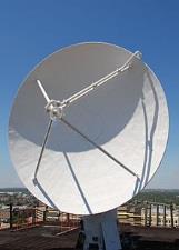
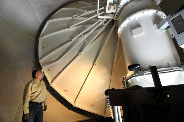
6 Operational Radar A.k.a., the things you see on Gibson Ridge software. Current radars: WSR-88D s (NEXRAD) Weather Surveillance Radar made operational in 1988 and are of the doppler variety. Previous radars were WSR-57 s and WSR-74 s. 28 ft diameter dish that rotates at 360º at several tilts. Dual polarization and phased-array are future radar types soon to be implemented. Course notes pictures.
7

8 Sites 159 Sites

9 Image provided by Rich Kinney, NWS, Des Moines

10 Images provided by Rich Kinney, NWS, Des Moines
11
12 VCP Volume coverage pattern Modes: Convection, shallow precipitation, clear air. Convection: Two digits starting with a 1. Shallow precipitation: Two digits starting with a 2. Clear air: Two digits starting with a 3. Very sensitive, used when there is not precipitation detected in the coverage area. Multiple PRF Dealiasing Algorithm Group: Three digits, starting with a 1 and followed by the two digit VCP with similar elevation angles. VCP 31 and VCP 32 Clear air mode, 10 minute complete scan, 0.5 (base) degrees with 5 cuts (0.5, 1.5, 2.5, 3.5, 4.5). VCP 21 Precipitation mode, 6 minute, 0.5 (base) degrees with 9 cuts. VCP 11 Severe Weather (precip mode), 5 minute, 0.5 (base) with 14 cuts
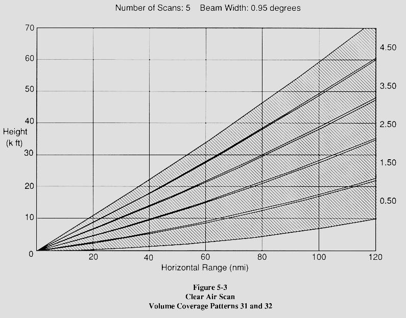
13 VCP 31
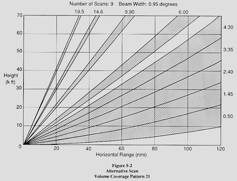
14 VCP 21
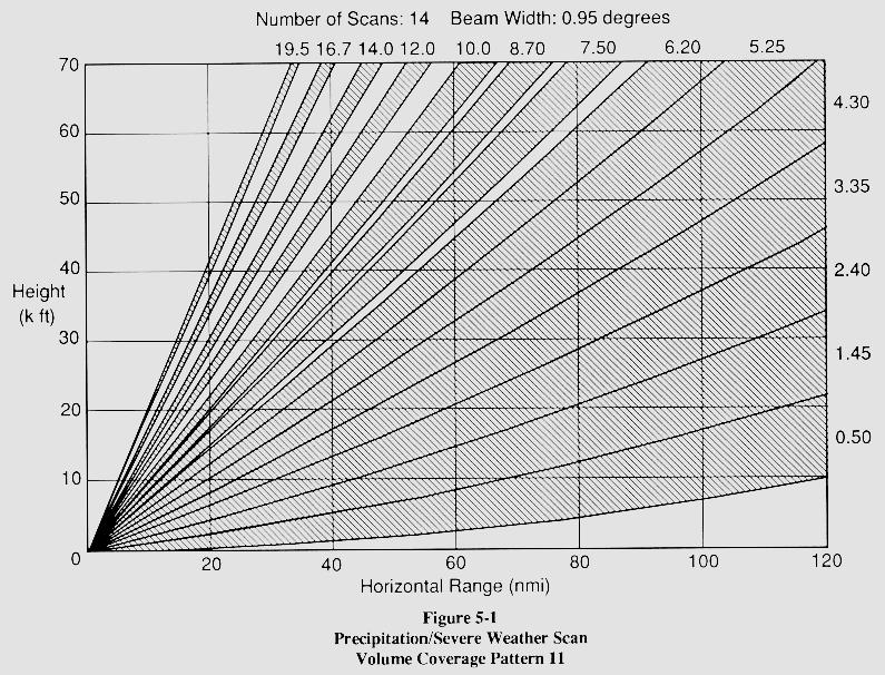
15 VCP 11
16 Newer VCP s VCP 211, 212, 221 Same elevation angles as VCP 11, 12, and 21. Sachidananda-Zrnic Algorithm (SZ-2) Reduces range ambiguity for Doppler data.
17 PRF Pulse repetition frequency Frequency at which pulses are emitted (pulses per second). Essentially how long the listening stage is (PRT = 1/PRF). Determines the maximum unambiguous range and maximum unambiguous velocity Huh? R max = maximum range which a transmitted pulse wave can travel and return to the radar before the next pulse is emitted. R max = C / (2*PRF) Huh, again? V max = maximum velocity which a Doppler radar can determine unambiguously. V max = ( * PRF) / 4 Purple haze: Radar cannot determine which pulse return signal may have come from. Also called Range folding. Doppler Dilemma.
18
19
20 Products or Moments Base reflectivity: Lowest elevation scan. Basically used to tell what is out there. Composite reflectivity: Composed of the greatest reflectivity from any elevation angle seen from the radar. Used to reveal the highest reflectivity in all echoes. Base velocity Provides basic wind field from the 0.5º elevation scan via Doppler effect. Radar can only measure motions that have a component along a radial, or essentially toward or away from the radar. Spectrum width Spread in the velocity values. Large spectrum width means a lot of turbulence. Storm relative motion: Used to detect mesoscale circulations. Mean wind field is subtracted from base velocity. VIL Vertically integrated liquid water. Amount of liquid water that the radar detects in a vertical column of the atmosphere for an area of precipitation. High values are associated with heavy rain or hail. Echo Tops Maximum height of precipitation echoes.
21 Base Reflectivity
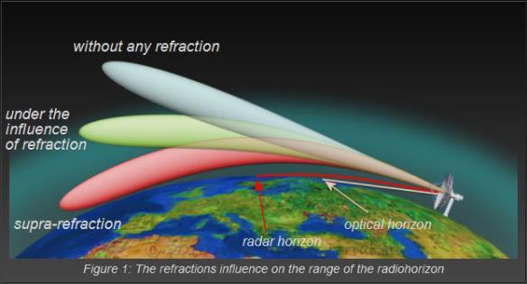
 Nautical miles 0 5 10 Hook echo WSR-88D Radar Image Images provided by Rich Kinney,")
22 Classic Supercell N Light Rain Moderate/Heavy Rain & Hail Gust Front Hook echo Anvil Edge Supercell Thunderstorm (top view) Nautical miles Hook echo WSR-88D Radar Image Images provided by Rich Kinney, NWS, Des Moines
23 Composite Reflectivity Jetstream - An Online School for Weather: RIDGE radar composite reflectivity
24 Cool Stuff Introduction to NEXRAD Anomalies & Artifacts
25 TBSS
26 TBSS National Weather Service Forecast Office - Midland/Odessa Texas Figure #16.

27 Bright Banding Radar beam intersects freezing level and intersects melting precipitation. Image provided by Rich Kinney, NWS, Des Moines

28 Radar fine line 88D can detect subtle differences in humidity and temperature, and the location of boundaries that may be the focus for storm initiation or intensification Image provided by Rich Kinney, NWS, Des Moines

29 AP Anomalous propagation.
30 Dual Polarization Two beams with different polarization directions: one with horizontal polarization (current polarization) and one with vertical polarization New products useful for: Precipitation type. Rain and snow rate estimates. Identification of aircraft icing conditions. Reference: Page produced by Kevin Scharfenberg, who was also an invited speaker at the 2008 Severe Storms and Doppler Radar Conference hosted by the Central Iowa NWA.
31 Dual Polarization
Remote Sensing in Meteorology: Satellites and Radar. AT 351 Lab 10 April 2, Remote Sensing
 Remote Sensing in Meteorology: Satellites and Radar AT 351 Lab 10 April 2, 2008 Remote Sensing Remote sensing is gathering information about something without being in physical contact with it typically
Fundamentals of Radar Display. Atmospheric Instrumentation
 Fundamentals of Radar Display Outline Fundamentals of Radar Display Scanning Strategies Basic Geometric Varieties WSR-88D Volume Coverage Patterns Classic Radar Displays and Signatures Precipitation Non-weather
Estimating the Impact of a 3-dB Sensitivity Loss on WSR-88D Data
 P12R.9 Estimating the Impact of a 3-dB Sensitivity Loss on WSR-88D Data Kevin A. Scharfenberg*, Kim L. Elmore, Eddie Forren, and Valery Melnikov Cooperative Institute for Mesoscale Meteorology Studies,
Lecture 15: Doppler Dilemma, Range and Velocity Folding, and Interpreting Doppler velocity patterns
 MET 4410 Remote Sensing: Radar and Satellite Meteorology MET 5412 Remote Sensing in Meteorology Lecture 15: Doppler Dilemma, Range and Velocity Folding, and Interpreting Doppler velocity patterns Doppler
ATS 351, Spring 2010 Lab #9 Weather Radar - 55 points
 ATS 351, Spring 2010 Lab #9 Weather Radar - 55 points 1. (5 points) If a radar has a maximum unambiguous range of 300km, what is its PRF? (The speed of light, c, is equal to 3x10 8 m/s) The equation to
THE DETECTABILITY OF TORNADIC SIGNATURES WITH DOPPLER RADAR: A RADAR EMULATOR STUDY
 P15R.1 THE DETECTABILITY OF TORNADIC SIGNATURES WITH DOPPLER RADAR: A RADAR EMULATOR STUDY Ryan M. May *, Michael I. Biggerstaff and Ming Xue University of Oklahoma, Norman, Oklahoma 1. INTRODUCTION The
Module 11: Meteorology Topic 5 Content: Weather Maps Notes
 Introduction A variety of weather maps are produced by the National Weather Service and National Oceanographic Atmospheric Administration. These maps are used to help meteorologists accurately predict
Climate & Earth System Science. Introduction to Meteorology & Climate. Chapter 05 SOME OBSERVING INSTRUMENTS. Instrument Enclosure.
 Climate & Earth System Science Introduction to Meteorology & Climate MAPH 10050 Peter Lynch Peter Lynch Meteorology & Climate Centre School of Mathematical Sciences University College Dublin Meteorology
Robert E. Saffle * Mitretek Systems, Inc., Falls Church, VA
 5.1 NEXRAD Product Improvement - Expanding Science Horizons Robert E. Saffle * Mitretek Systems, Inc., Falls Church, VA Michael J. Istok National Weather Service, Office of Science and Technology, Silver
The Montague Doppler Radar, An Overview
 ISSUE PAPER SERIES The Montague Doppler Radar, An Overview June 2018 NEW YORK STATE TUG HILL COMMISSION DULLES STATE OFFICE BUILDING 317 WASHINGTON STREET WATERTOWN, NY 13601 (315) 785-2380 WWW.TUGHILL.ORG
Convective Structures in Clear-Air Echoes seen by a Weather Radar
 Convective Structures in Clear-Air Echoes seen by a Weather Radar Martin Hagen Deutsches Zentrum für Luft- und Raumfahrt Oberpfaffenhofen, Germany Weather Radar Weather radar are normally used to locate
Weather vs. Climate. Tucson NWS homepage:
 Weather vs. Climate Tucson NWS homepage: www.nws.noaa.gov/twc/ A Weather Forecaster? Betty claims to know exactly when it s going to rain because her knee starts to hurt. Ms. Betty Martin of Newburgh,
Is Spectral Processing Important for Future WSR-88D Radar?
 Is Spectral Processing Important for Future WSR-88D Radar? Carlos A. Rodríguez Rivera University of Puerto Rico, Mayagüez Campus Mentor: Dr. Robert Palmer University of Oklahoma Abstract: Processing speed
NOAA S National Weather Service
 NOAA S National Weather Service Night Spotting Advanced Concepts of Severe Storm Spotting 2012 Rusty Kapela Milwaukee/Sullivan Weather.gov/milwaukee Problems Spotters Encounter Spotters can only see a
Lab 6 Radar Imagery Interpretation
 Lab 6 Radar Imagery Interpretation Background Weather radar (radio detection and ranging) is another very useful remote sensing tool used in meteorological forecasting. Microwave radar was developed in
How to Effectively Use Weather Radar. Presented by: Robert Reale Company:
 How to Effectively Use Weather Radar Presented by: Robert Reale Company: Who Am I? What is WeatherWorks? WeatherWorks Private weather consulting firm located in Hackettstown, NJ Over 30 years in the snow
UNIVERSITY OF OKLAHOMA GRADUATE COLLEGE POLARIMETRIC RADAR SIGNATURES IN DAMAGING DOWNBURST PRODUCING THUNDERSTORMS. A thesis
 UNIVERSITY OF OKLAHOMA GRADUATE COLLEGE POLARIMETRIC RADAR SIGNATURES IN DAMAGING DOWNBURST PRODUCING THUNDERSTORMS A thesis SUBMITTED TO THE GRADUATE FACULTY in partial fulfillment of the requirements
Weather Launch Console and Jobs. Stephanie Stevenson
 Weather Launch Console and Jobs Stephanie Stevenson 1 NASA s Mission NASA's mission is to pioneer future space exploration, scientific discovery, and aeronautics research. Your job is to support the mission
5.3 THREE BODY SCATTER SIGNATURE PRODUCING UNCERTAINTIES IN DOPPLER RADIAL VELOCITY STRUCTURES
 5.3 THREE BODY SCATTER SIGNATURE PRODUCING UNCERTAINTIES IN DOPPLER RADIAL VELOCITY STRUCTURES Aurora Stan-Sion *, D. V. Carbunaru and B. Antonescu National Meteorological Administration, Bucharest, Romanian
Polarization Diversity for the National Weather Service (NWS), WSR-88D radars
, WSR-88D radars") Polarization Diversity for the National Weather Service (NWS), WSR-88D radars Dusan S. Zrnic National Severe Storm Laboratory Norman, OK 73069, USA In the early eighties the NOAA s National Severe Storms
Polarization Diversity for the National Weather Service (NWS), WSR-88D radars Dusan S. Zrnic National Severe Storm Laboratory Norman, OK 73069, USA In the early eighties the NOAA s National Severe Storms
Utilization of Dual-pol data
 WMO/ASEAN Training Workshop on Weather Radar Data Quality and Standardization Utilization of Dual-pol data 8 February 2018 Hiroshi Yamauchi Observation Department Japan Meteorological Agency Japan Meteorological
Meteorology Lecture 18
 Meteorology Lecture 18 Robert Fovell rfovell@albany.edu 1 Important notes These slides show some figures and videos prepared by Robert G. Fovell (RGF) for his Meteorology course, published by The Great
Robert E. Saffle * Noblis, Inc., Falls Church, VA. Michael J. Istok National Weather Service, Office of Science and Technology, Silver Spring, MD
 6B.1 NEXRAD PRODUCT IMPROVEMENT UPDATE 2008 Robert E. Saffle * Noblis, Inc., Falls Church, VA Michael J. Istok National Weather Service, Office of Science and Technology, Silver Spring, MD Greg Cate National
Chapter 3 Convective Dynamics 3.4. Bright Bands, Bow Echoes and Mesoscale Convective Complexes
 Chapter 3 Convective Dynamics 3.4. Bright Bands, Bow Echoes and Mesoscale Convective Complexes Photographs Todd Lindley Bright band associated with stratiform precipitation in a squall line system 1 Bright
Aviation Hazards: Thunderstorms and Deep Convection
 Aviation Hazards: Thunderstorms and Deep Convection TREND Diagnosis of thunderstorm hazards using imagery Contents Satellite imagery Visible, infrared, water vapour Basic cloud identification Identifying
10/21/2012. Chapter 10 Thunderstorms. Part II. Growth and Development of ordinary Cell Thunderstorms Thunderstorm Electrification.
 Chapter 10 Thunderstorms Part I Growth and Development of ordinary Cell Thunderstorms Thunderstorm Electrification Tornadoes Part II Simplified model depicting the life cycle of an ordinary thunderstorm
Chapter 3 Convective Dynamics Part V ñ Bright Bands, Bow Echoes and MCCs. Bright band associated with stratiform precipitation in a squall line system
 Chapter 3 Convective Dynamics Part V ñ Bright Bands, Bow Echoes and MCCs Photographs Todd Lindley (This part contains materials taken from UCAR MCS training module) Bright band associated with stratiform
System Requirements for Phased Array Weather Radar. Table of Contents
 System Requirements for Phased Array Weather Radar Dusan S. Zrnic and Richard J. Doviak National Severe Storms Laboratory, Norman OK Table of Contents Preamble... 1 1. INTRODUCTION... 1 2. WEATHER RADAR
Assimilation of Satellite Infrared Brightness Temperatures and Doppler Radar Observations in a High-Resolution OSSE
 Assimilation of Satellite Infrared Brightness Temperatures and Doppler Radar Observations in a High-Resolution OSSE Jason Otkin and Becky Cintineo University of Wisconsin-Madison, Cooperative Institute
*Corresponding author address: Charles Barrere, Weather Decision Technologies, 1818 W Lindsey St, Norman, OK
 P13R.11 Hydrometeorological Decision Support System for the Lower Colorado River Authority *Charles A. Barrere, Jr. 1, Michael D. Eilts 1, and Beth Clarke 2 1 Weather Decision Technologies, Inc. Norman,
Weather Compass Webquest: Lab/Activity Edition
 Weather Compass Webquest: Lab/Activity Edition www.weathercompass.webs.com 1 Name: Date: Welcome to the Weather Compass Webquest: Activity/Lab Edition. This webquest was created by the National Oceanic
Figure 5: Comparison between SAFIR warning and radar-based hail detection for the hail event of June 8, 2003.
 SAFIR WARNING : Expected risk Radar-based Probability of Hail 0915 0930 0945 1000 Figure 5: Comparison between SAFIR warning and radar-based hail detection for the hail event of June 8, 2003. Lightning
Thunderstorm Downburst Prediction: An Integrated Remote Sensing Approach. Ken Pryor Center for Satellite Applications and Research (NOAA/NESDIS)
") Thunderstorm Downburst Prediction: An Integrated Remote Sensing Approach Ken Pryor Center for Satellite Applications and Research (NOAA/NESDIS) Topics of Discussion Thunderstorm Life Cycle Thunderstorm
Thunderstorm Downburst Prediction: An Integrated Remote Sensing Approach Ken Pryor Center for Satellite Applications and Research (NOAA/NESDIS) Topics of Discussion Thunderstorm Life Cycle Thunderstorm
TOPICS: What are Thunderstorms? Ingredients Stages Types Lightning Downburst and Microburst
 THUNDERSTORMS TOPICS: What are Thunderstorms? Ingredients Stages Types Lightning Downburst and Microburst What are Thunderstorms? A storm produced by a cumulonimbus cloud that contains lightning and thunder
The Hydrologic Cycle: How Do River Forecast Centers Measure the Parts?
 The Hydrologic Cycle: How Do River Forecast Centers Measure the Parts? Greg Story Meteorologist National Weather Service Fort Worth, TX Overview n Introduction What is the mission of an RFC? n The Hydrologic
P5.4 WSR-88D REFLECTIVITY QUALITY CONTROL USING HORIZONTAL AND VERTICAL REFLECTIVITY STRUCTURE
 P5.4 WSR-88D REFLECTIVITY QUALITY CONTROL USING HORIZONTAL AND VERTICAL REFLECTIVITY STRUCTURE Jian Zhang 1, Shunxin Wang 1, and Beth Clarke 1 1 Cooperative Institute for Mesoscale Meteorological Studies,
ERAD THE EIGHTH EUROPEAN CONFERENCE ON RADAR IN METEOROLOGY AND HYDROLOGY
 ERAD 2014 - THE EIGHTH EUROPEAN CONFERENCE ON RADAR IN METEOROLOGY AND HYDROLOGY Microphysical interpretation of coincident simultaneous and fast alternating horizontal and vertical polarization transmit
ATS 351, Spring 2010 Lab #9 Weather Radar - 55 points
 ATS 351, Spring 2010 Lab #9 Weather Radar - 55 points 1. (5 points) If a radar has a maximum unambiguous range of 300km, what is its PRF? (The speed of light, c, is equal to 3x10 8 m/s) 2. (5 points) Explain
III. Section 3.3 Vertical air motion can cause severe storms
 III. Section 3.3 Vertical air motion can cause severe storms http://www.youtube.com/watch?v=nxwbr60tflg&feature=relmfu A. Thunderstorms form from rising moist air Electrical charges build up near the tops
Chapter 2: Polarimetric Radar
 Chapter 2: Polarimetric Radar 2.1 Polarimetric radar vs. conventional radar Conventional weather radars transmit and receive linear electromagnetic radiation whose electric field is parallel to the local
Validation of Hydrometeor Classification Method for X-band Polarimetric Radars using In Situ Observational Data of Hydrometeor Videosonde
 Validation of Hydrometeor Classification Method for X-band Polarimetric Radars using In Situ Observational Data of Hydrometeor Videosonde Takeharu Kouketsu 1*, Hiroshi Uyeda 1, Mariko Oue 1, Tadayasu Ohigashi
Weather Radar and A3 Introduction
 Weather Radar and A3 Introduction The term RADAR is an acronym formed from the term Radio Detection and Ranging. Nikola Tesla (of electric car fame) suggested in 1900 that moving targets should be observable
Exam 2 Results (20% toward final grade)
") Exam 2 Results (20% toward final grade) Score between 90-99: 6 students (3 grads, 3 under) Score between 80-89: 2 students Score between 70-79: 3 students Score between 60-69: 2 students Below 59: 1 student
Exam 2 Results (20% toward final grade) Score between 90-99: 6 students (3 grads, 3 under) Score between 80-89: 2 students Score between 70-79: 3 students Score between 60-69: 2 students Below 59: 1 student
A Description of Convective Weather Containing Ice Crystals Associated with Engine Powerloss and Damage
 A Description of Convective Weather Containing Ice Crystals Associated with Engine Powerloss and Damage The Boeing Company 1 Photo: courtesy of Ian McPherson The Boeing Company acknowledges the contributions
5.4 Comparison of Storm Evolution Characteristics: The NWRT and WSR-88D
 5.4 Comparison of Storm Evolution Characteristics: The NWRT and WSR-88D Pamela Heinselman, David Priegnitz, Kevin Manross, and Richard Adams Cooperative Institute for Mesoscale Meteorological Studies,
Meteorology. Review Extreme Weather a. cold front. b. warm front. What type of weather is associated with a:
 Meteorology 5.08 Extreme Weather References: FTGU pages 132, 144, 145, 148-155 Air Command Weather Manual Chapters 9 and 15 Review What type of weather is associated with a: a. cold front b. warm front
WEATHER RADAR PRINCIPLES
 2017 RA-IV WMO Tropical Meteorology Course 1 March 2017 WEATHER RADAR PRINCIPLES Stacy Stewart Senior Hurricane Specialist NOAA/National Hurricane Center, Miami, Florida COURSE OBJECTIVES Part 1. Brief
Remote Sensing Observations AOSC 200 Tim Canty
 Remote Sensing Observations AOSC 200 Tim Canty Class Web Site: http://www.atmos.umd.edu/~tcanty/aosc200 Topics for today: Maps Radar Satellite Observations Lecture 04 Feb 7 2019 1 Today s Weather Map http://www.wpc.ncep.noaa.gov/sfc/namussfcwbg.gif
Dual-Pol RadarFirst Lab Exercise
 Dual-Pol RadarFirst Lab Exercise Possible Uses of Dual-Pol Radar Data for Emergency Management Objective: This exercise serves as a first introduction to using dual-pol radar data. In the lab, you will
Comparison of polarimetric radar signatures in hailstorms simultaneously observed by C-band and S-band radars.
 Comparison of polarimetric radar signatures in hailstorms simultaneously observed by C-band and S-band radars. R. Kaltenboeck 1 and A. Ryzhkov 2 1 Austrocontrol - Aviation Weather Service, Vienna and Institute
RODGER A. BROWN NOAA/National Severe Storms Laboratory, Norman, OK
 Preprints, 25th Intern. Conf. on Interactive Information and Processing Systems, Phoenix, AZ, Amer. Meteor. Soc., January 2009 9B.3 Progress Report on the Evolutionary Characteristics of a Tornadic Supercell
A study of coastal convective clouds using meteorological radar data
 Scientific Journals of the Maritime University of Szczecin Zeszyty Naukowe Akademii Morskiej w Szczecinie 2016, 48 (120), 81 87 ISSN 1733-8670 (Printed) Received: 29.04.2016 ISSN 2392-0378 (Online) Accepted:
Thunderstorms. Ordinary Cell Thunderstorms. Ordinary Cell Thunderstorms. Ordinary Cell Thunderstorms 5/2/11
 A storm containing lightning and thunder; convective storms Chapter 14 Severe thunderstorms: At least one: large hail wind gusts greater than or equal to 50 kt Tornado 1 2 Ordinary Cell Ordinary Cell AKA
Evaluation of Potential NEXRAD Dual Polarization Products
 Project Report ATC-336 Evaluation of Potential NEXRAD Dual Polarization Products D.J. Smalley 4 September 2007 Lincoln Laboratory MASSACHUSETTS INSTITUTE OF TECHNOLOGY LEXINGTON, MASSACHUSETTS Prepared
Ecography. Supplementary material
 Ecography ECOG-04028 Dokter, A. M., Desmet, P., Spaaks, J. H., van Hoey, S., Veen, L., Verlinden, L., Nilsson, C., Haase, G., Leijnse, H., Farnsworth, A., Bouten, W. and Shamoun-Baranes, J. 2019. biorad:
Introduction. Suita. Kobe. Okinawa. Tsukuba. Tokyo? in in in in 2017 See Poster #16 2. in 2015
 1 Introduction We developed the X band Phased Array Weather Radar (PAWR) to watch and predict severe weather disasters caused by localized heavy rainfalls or tornadoes. The PAWR measures 3 dimentional
HAZARDOUS WEATHER 1. Dr. Julie Laity Geography 266
 HAZARDOUS WEATHER 1 Dr. Julie Laity Geography 266 Violent Weather Thunderstorms Atmospheric turbulence Lightning and thunder Hail Derechos Tornadoes Tornado measurement and science Tropical Cyclones Hurricanes
(Preliminary) Observations of Tropical Storm Fay Dustin W Phillips Kevin Knupp, & Tim Coleman. 34th Conference on Radar Meteorology October 8, 2009
 Observations of Tropical Storm Fay Dustin W Phillips Kevin Knupp, & Tim Coleman. 34th Conference on Radar Meteorology October 8, 2009") (Preliminary) Observations of Tropical Storm Fay Dustin W Phillips Kevin Knupp, & Tim Coleman 34th Conference on Radar Meteorology October 8, 2009 Outline I. Research Equipment MIPS, MAX, KJAX (WSR-88D)
(Preliminary) Observations of Tropical Storm Fay Dustin W Phillips Kevin Knupp, & Tim Coleman 34th Conference on Radar Meteorology October 8, 2009 Outline I. Research Equipment MIPS, MAX, KJAX (WSR-88D)
Precipitation Processes. Precipitation Processes 2/24/11. Two Mechanisms that produce raindrops:
 Precipitation is any form of water that falls from a cloud and reaches the ground. How do cloud drops grow? Chapter 7 When air is saturated with respect to a flat surface it is unsaturated with respect
Thunderstorm: a cumulonimbus cloud or collection of cumulonimbus clouds featuring vigorous updrafts, precipitation and lightning
 Thunderstorm: a cumulonimbus cloud or collection of cumulonimbus clouds featuring vigorous updrafts, precipitation and lightning Thunderstorms are responsible for most of what we refer to as severe weather,
Reading. What meteorological conditions precede a thunderstorm? Thunderstorms: ordinary or single cell storms, multicell storms, supercell storms
 Thunderstorms: ordinary or single cell storms, multicell storms, supercell storms Reading Ahrens, Chapter 14: Thunderstorms and Tornadoes This lecture + next (Lightning, tornadoes) will cover the topic.
Weather can change quickly...are you on top of the changes?
 Weather Access Bob Glancy NOAA National Weather Service, Boulder, CO Near Cedar Point, CO May 9, 2004 Weather can change quickly...are you on top of the changes? National Weather Service Local offices:
THUNDERSTORM LIGHTNING DATA
 THUNDERSTORM EVOLUTION ANALYSIS AND ESTIMATION USING RADAR AND TOTAL LIGHTNING DATA Jianhua Dai 1,2 *, Yuan Wang 1, Lei Chen 2, Lan Tao 2, Hong Lin 2 1. Department of Atmospheric Sciences, Key Laboratory
Real time mitigation of ground clutter
 Real time mitigation of ground clutter John C. Hubbert, Mike Dixon and Scott Ellis National Center for Atmospheric Research, Boulder CO 1. Introduction The identification and mitigation of anomalous propagation
The HIAPER Cloud Radar Performance and Observations During Winter Storm Observations of a Nor easter
 The HIAPER Cloud Radar Performance and Observations During Winter Storm Observations of a Nor easter S. Ellis 1*, R. Rauber 2, P. Tsai 1, J. Emmett 1, E. Loew 1, C. Burghart 1, M. Dixon 1, J. Vivekanandan
Answers to Clicker Questions
 Answers to Clicker Questions Chapter 1 What component of the atmosphere is most important to weather? A. Nitrogen B. Oxygen C. Carbon dioxide D. Ozone E. Water What location would have the lowest surface
Test Form: A Key Final Exam: Spring 2011
 Test Form: A Key Final Exam: Spring 2011 Instructions: Write your name (last name and first name) on your bubble sheet. Write your student identification number on the bubble sheet, and carefully and completely
DEPARTMENT OF EARTH & CLIMATE SCIENCES SAN FRANCISCO STATE UNIVERSITY. Metr Fall 2014 Test #1 September 30, 2014
 DEPARTMENT OF EARTH & CLIMATE SCIENCES SAN FRANCISCO STATE UNIVERSITY NAME Metr 302.02 Fall 2014 Test #1 September 30, 2014 200 pts (4 pts each answer) Part I. Surface Chart Interpretation. Questions 1
Observing Weather: Making the Invisible Visible. Dr. Michael J. Passow
 Observing Weather: Making the Invisible Visible Dr. Michael J. Passow What Is Weather? Weather refers to the conditions of the atmosphere at a certain place and time. Weather differs from Climate, which
Thunderstorm: a cumulonimbus cloud or collection of cumulonimbus clouds featuring vigorous updrafts, precipitation and lightning
 Thunderstorm: a cumulonimbus cloud or collection of cumulonimbus clouds featuring vigorous updrafts, precipitation and lightning Thunderstorm: a cumulonimbus cloud or collection of cumulonimbus clouds
Maps and Remote Sensing AOSC 200 Tim Canty
 Maps and Remote Sensing AOSC 200 Tim Canty Class Web Site: http://www.atmos.umd.edu/~tcanty/aosc200 Topics for today: Weather Maps Radar Satellite Observations Lecture 04 Feb 7 2019 1 Today s Weather Map
Hail Size Determination from Three-Body Scatter Spikes Using Dual-Pol Radar
 Hail Size Determination from Three-Body Scatter Spikes Using Dual-Pol Radar William Martin National Weather Service WFO Glasgow, MT AMS Annual Meeting, Atlanta Georgia February 2013 Example of a good scatter
A new mesoscale NWP system for Australia
 A new mesoscale NWP system for Australia www.cawcr.gov.au Peter Steinle on behalf of : Earth System Modelling (ESM) and Weather&Environmental Prediction (WEP) Research Programs, CAWCR Data Assimilation
Multi-Sensor Precipitation Reanalysis
 Multi-Sensor Precipitation Reanalysis Brian R. Nelson, Dongsoo Kim, and John J. Bates NOAA National Climatic Data Center, Asheville, North Carolina D.J. Seo NOAA NWS Office of Hydrologic Development, Silver
Mr. P s Science Test!
 WEATHER- 2017 Mr. P s Science Test! # Name Date 1. Draw and label a weather station model. (10 pts) 2. The is the layer of the atmosphere with our weather. 3. Meteorologists classify clouds in about different
Tornadoes. tornado: a violently rotating column of air
 Tornadoes tornado: a violently rotating column of air Tornadoes What is the typical size of a tornado? What are typical wind speeds for a tornado? Five-stage life cycle of a tornado Dust Swirl Stage Tornado
Weather Legends in FOREFLIGHT MOBILE
 Weather Legends in FOREFLIGHT MOBILE 14th Edition Covers ForeFlight Mobile v9.4 on ipad Radar Legends (when from Internet) Snowy/Icy Precipitation Mixed Precipitation Rain Echo top (in 100 s of feet) ex:
Remote Sensing of Precipitation
 Lecture Notes Prepared by Prof. J. Francis Spring 2003 Remote Sensing of Precipitation Primary reference: Chapter 9 of KVH I. Motivation -- why do we need to measure precipitation with remote sensing instruments?
Sunday, 13 June 1999
 Sunday, 13 June 1999 Julian Day 164 Meteorological Summary A cold front moved in over night, cooling the air at low levels. Warming aloft occurred and stabilized the air in mid-levels, suppressing convective
Tornadogenesis in Supercells: The Three Main Ingredients. Ted Funk
 Tornadogenesis in Supercells: The Three Main Ingredients Ted Funk NWS Louisville, KY Spring 2002 Environmental Parameters Supercells occur within environments exhibiting several wellknown characteristics
Thunderstorm Forecasting and Warnings in the US: Applications to the Veneto Region
 Thunderstorm Forecasting and Warnings in the US: Applications to the Veneto Region Bill Conway Vice President Weather Decision Technologies Norman, Oklahoma, USA Andrea Rossa ARPAV Lead Scientist Centre
` READING: Weather (Level 1)
") ` READING: Weather (Level 1) 1. Launch Weather Overview The launch weather guidelines for the Space Shuttle and expendable rockets are the same in many areas, but are different for the individual parts.
` READING: Weather (Level 1) 1. Launch Weather Overview The launch weather guidelines for the Space Shuttle and expendable rockets are the same in many areas, but are different for the individual parts.
The Ice Crystal Weather Threat to Engines
 Jeanne Mason Boeing Commercial Airplanes The Ice Crystal Weather Threat to Engines BOEING is a trademark of Boeing Management Company. Filename.ppt 1 Agenda Introduction Recognition of engine power-loss
Severe Weather Watches, Advisories & Warnings
 Severe Weather Watches, Advisories & Warnings Tornado Watch Issued by the Storm Prediction Center when conditions are favorable for the development of severe thunderstorms and tornadoes over a larger-scale
Introduction. Sunny Partly Cloudy Cloudy. Flurries Snow Ice. Showers Thunderstorms Rain. High Pressure Low Pressure FRONTS. Cold Warm Stationary
 Introduction Weather can change from minute to minute, hour to hour, day to day, or season to season. Meteorologists are scientists who study Earth s atmosphere in order to predict these changes. Meteorologists
SEVERE AND UNUSUAL WEATHER
 SEVERE AND UNUSUAL WEATHER Basic Meteorological Terminology Adiabatic - Referring to a process without the addition or removal of heat. A temperature change may come about as a result of a change in the
24 TH CONFERENCE ON SEVERE LOCAL STORMS, OCTOBER 2008, SAVANNAH, GEORGIA
 P9.13 SUPER-RESOLUTION POLARIMETRIC OBSERVATIONS OF A CYCLIC TORNADIC SUPERCELL MATTHEW R. KUMJIAN*, ALEXANDER V. RYZHKOV, AND VALERY M. MELNIKOV Cooperative Institute for Mesoscale Meteorological Studies,
Temperature (T) degrees Celsius ( o C) arbitrary scale from 0 o C at melting point of ice to 100 o C at boiling point of water Also (Kelvin, K) = o C
 degrees Celsius ( o C) arbitrary scale from 0 o C at melting point of ice to 100 o C at boiling point of water Also (Kelvin, K) = o C") 1 2 3 4 Temperature (T) degrees Celsius ( o C) arbitrary scale from 0 o C at melting point of ice to 100 o C at boiling point of water Also (Kelvin, K) = o C plus 273.15 0 K is absolute zero, the minimum
1 2 3 4 Temperature (T) degrees Celsius ( o C) arbitrary scale from 0 o C at melting point of ice to 100 o C at boiling point of water Also (Kelvin, K) = o C plus 273.15 0 K is absolute zero, the minimum
Linked Environments for Atmospheric Discovery: Web Services for Meteorological Research and Education
 Linked Environments for Atmospheric Discovery: Web Services for Meteorological Research and Education What Would YOU Do if These Were About to Occur? What THEY Do to Us!!! Each year in the US, mesoscale
777 GROUNDSCHOOL Temperature, Stability, Fronts, & Thunderstorms
 777 GROUNDSCHOOL 2018 Temperature, Stability, Fronts, & Thunderstorms The Atmosphere Heating Transfer of heat occurs thru Radiation Advection Convection Matter changes states due to the amount of heat
Precipitation AOSC 200 Tim Canty. Cloud Development: Orographic Lifting
 Precipitation AOSC 200 Tim Canty Class Web Site: http://www.atmos.umd.edu/~tcanty/aosc200 Topics for today: Precipitation formation Rain Ice Lecture 14 Oct 11 2018 1 Cloud Development: Orographic Lifting
Review of Basic Severe Thunderstorm & Tornado Spotting Concepts. Jim Allsopp National Weather Service Chicago/Romeoville, IL
 Review of Basic Severe Thunderstorm & Tornado Spotting Concepts Jim Allsopp National Weather Service Chicago/Romeoville, IL Why Do We Need Spotters? Radar has limitations, only spotters can provide view
Chapter Introduction. Weather. Patterns. Forecasts Chapter Wrap-Up
 Chapter Introduction Lesson 1 Lesson 2 Lesson 3 Describing Weather Weather Patterns Weather Forecasts Chapter Wrap-Up How do scientists describe and predict weather? What do you think? Before you begin,
APPLICATION OF SPECTRAL POLARIMETRY TO A HAILSTORM AT LOW ELEVATION ANGLE
 13A.3 1 APPLICATION OF SPECTRAL POLARIMETRY TO A HAILSTORM AT LOW ELEVATION ANGLE T.-Y. Yu 1,2,3,, H. Le 1,2, Y. Wang 4,5, A. Ryzhkov 3,4,5, and M. Kumjian 6 1 School of Electrical and Computer Engineering,
ADL110B ADL120 ADL130 ADL140 How to use radar and strike images. Version
 ADL110B ADL120 ADL130 ADL140 How to use radar and strike images Version 1.00 22.08.2016 How to use radar and strike images 1 / 12 Revision 1.00-22.08.2016 WARNING: Like any information of the ADL in flight
LIGHTNING ACTIVITY AND CHARGE STRUCTURE OF MICROBURST PRODUCING STORMS
 LIGHTNING ACTIVITY AND CHARGE STRUCTURE OF MICROBURST PRODUCING STORMS Kristin M. Kuhlman, Travis M. Smith Cooperative Institute for Mesoscale Meteorological Studies, University of Oklahoma and NOAA/National
THE MESOSCALE CONVECTIVE SYSTEM FROM
 RISCURI I CATASTROFE, NR.X, VOL.9, NR. 1/2011 THE MESOSCALE CONVECTIVE SYSTEM FROM 24.07.2010 ELZA HAUER, 1 C. NICHITA 1 ABSTRACT. The Mesoscale Convective System from 24.07.2010. A severe weather event
IMPROVEMENTS OF POLARIMETRIC RADAR ECHO CLASSIFICATIONS. Ronald Hannesen* Selex-Gematronik, Neuss, Germany
 P13.14 IMPROVEMENTS OF POLARIMETRIC RADAR ECHO CLASSIFICATIONS Ronald Hannesen* Selex-Gematronik, Neuss, Germany 1. INTRODUCTION A two-step radar echo classification is applied on polarimetric radar data:
1 of 7 Thunderstorm Notes by Paul Sirvatka College of DuPage Meteorology. Thunderstorms
 1 of 7 Thunderstorm Notes by Paul Sirvatka College of DuPage Meteorology Thunderstorms There are three types of thunderstorms: single-cell (or air mass) multicell (cluster or squall line) supercell Although
Guided Notes Weather. Part 2: Meteorology Air Masses Fronts Weather Maps Storms Storm Preparation
 Guided Notes Weather Part 2: Meteorology Air Masses Fronts Weather Maps Storms Storm Preparation The map below shows North America and its surrounding bodies of water. Country borders are shown. On the