Weather vs. Climate. Tucson NWS homepage:
|
|
|
- Leslie Burke
- 5 years ago
- Views:
Transcription

1 Weather vs. Climate Tucson NWS homepage:


2 A Weather Forecaster? Betty claims to know exactly when it s going to rain because her knee starts to hurt. Ms. Betty Martin of Newburgh, IN Age 98 X NEWBURGH, IN
3 Definition of Weather Weather: Condition of the atmosphere at a particular time and place. Comprised of:
4 Definition of Weather Weather: Condition of the atmosphere at a particular time and place. Comprised of: Air temperature: Degree of hotness or coldness Air pressure: Force of the air above Humidity: Amount of water vapor in the air Clouds: Water droplets (liquid) or ice crystals (solid) above the surface Precipitation: Water that falls clouds and reaches ground Visibility: Farthest distance one can see. Wind: Horizontal movement of air

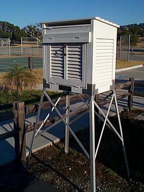
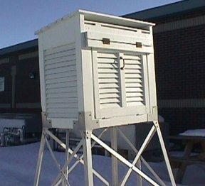
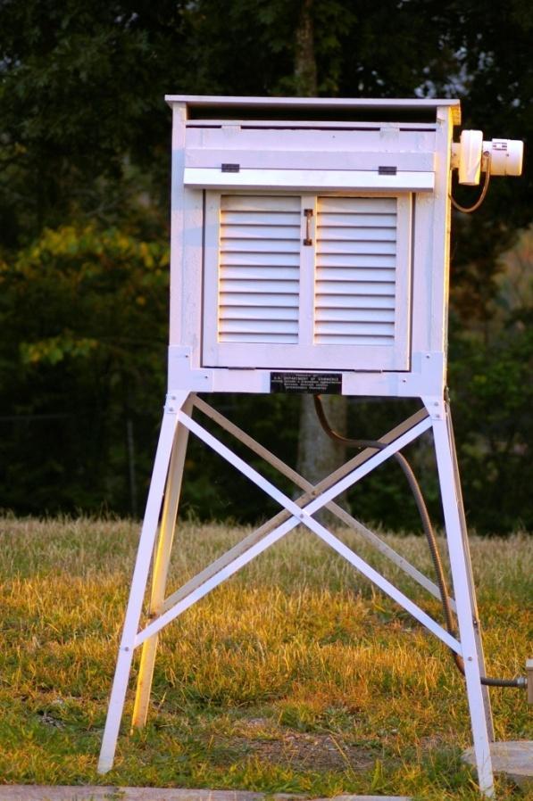
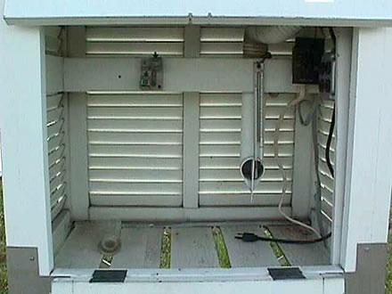
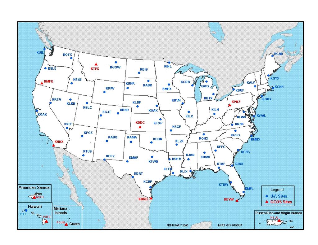
5 COTTON REGION SHELTER
6
7

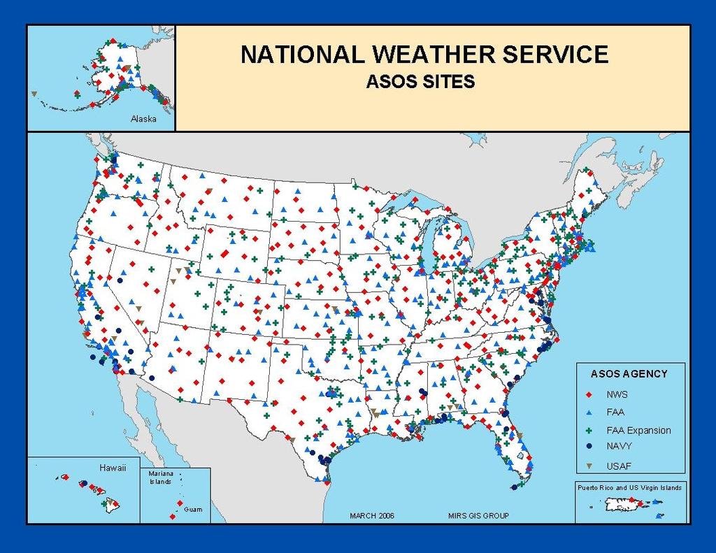
8 Automated Surface Observing System (ASOS)
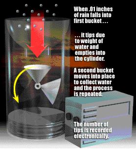
9
10
11 Surface Station Model (U.S.) Notes: Temperature and Wind Stations outside U.S. use degrees Celsius for temperature Wind barb direction reverses in southern hemisphere. Surface observations typically reported every three to six hours in U.S. at designated observing sites with a three letter identifier (e.g. NWS offices, airports).
12 Surface Station Model (U.S.) Notes: Pressure Leading 10 or 9 is not plotted for surface pressure Greater than 500 = 950 to 999 mb Less than 500 = 1000 to 1050 mb mb mb
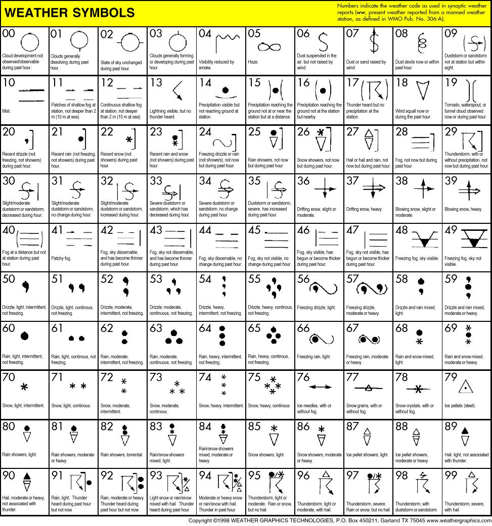
13 Sky Cover, Weather Symbols on a Surface Station Model
14
15 Surface Pressure Tendency
16 Wind Speed How to read: Half barb = 5 knots Full barb = 10 knots Flag = 50 knots 1 knot = 1 nautical mile per hour = 1.15 mph = 65 knots
17 Wind direction The direction of the barb reflects which way the wind is coming from NORTHERLY From the north WESTERLY From the west EASTERLY From the east SOUTHERLY From the south
18 Eastern Colorado Snowstorm (From UCAR RAP website)


")
19 What was happening in Colorado? (CNN images)

20 LIMON, COLORADO AMARILLO, TEXAS
21 Limon, Colorado (LIC) Weather conditions STATION IDENTIFIER
22 Limon, Colorado (LIC) Weather conditions TEMPERATURE Temperature: 21 F
23 Limon, Colorado (LIC) Weather conditions Temperature: 21 F Dewpoint: 18 F DEWPOINT
24 Limon, Colorado (LIC) Weather conditions Temperature: 21 F Dewpoint: 18 F Pressure: Not available PRESSURE
25 Limon, Colorado (LIC) Weather conditions Temperature: 21 F Dewpoint: 18 F Pressure: Not available Sky conditions: Overcast SKY CONDITIONS
26 Limon, Colorado (LIC) Weather conditions WIND SPEED AND DIRECTION Temperature: 21 F Dewpoint: 18 F Pressure: Not available Sky conditions: Overcast Wind: North-northwesterly at 30 knots, gusting to 34 knots.
27 Limon, Colorado (LIC) Weather conditions PRECIPITATION Temperature: 21 F Dewpoint: 18 F Pressure: Not available Sky conditions: Overcast Wind: North-northwesterly at 30 knots, gusting to 34 knots. Precipitation: Moderate Snow

28 Limon, Colorado (LIC) Weather conditions VISIBILITY Temperature: 21 F Dewpoint: 18 F Pressure: Not available Sky conditions: Overcast Wind: North-northwesterly at 30 knots Precipitation: Moderate Snow Visibility: Quarter mile
29 Amarillo, Texas (AMA) Weather conditions STATION IDENTIFIER
30 Amarillo, Texas (AMA) TEMPERATURE Weather conditions Temperature: 35 F
31 Amarillo, Texas (AMA) DEWPOINT Weather conditions Temperature: 35 F Dewpoint: 33 F
32 Amarillo, Texas (AMA) PRESSURE Weather conditions Temperature: 35 F Dewpoint: 33 F Pressure: mb
33 Amarillo, Texas (AMA) SKY CONDITIONS Weather conditions Temperature: 35 F Dewpoint: 33 F Pressure: mb Sky conditions: Overcast
34 Amarillo, Texas (AMA) Weather conditions WIND SPEED AND DIRECTION Temperature: 35 F Dewpoint: 33 F Pressure: mb Sky conditions: Overcast Wind: Northwesterly at 10 knots
35 Amarillo, Texas (AMA) Weather conditions PRECIPITATION Temperature: 35 F Dewpoint: 33 F Pressure: mb Sky conditions: Overcast Wind: Northwesterly at 10 knots Precipitation: Light rain
36 Amarillo, Texas (AMA) Weather conditions VISIBILITY Temperature: 35 F Dewpoint: 33 F Pressure: mb Sky conditions: Overcast Wind: Northwesterly at 10 knots Precipitation: Light rain Visibility: Five miles


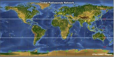
37 Upper Air Measurements Weather balloons, or radiosondes, sample atmosphere up to 10 mb. They measure: Temperature Moisture Pressure They are tracked to get winds using global positioning satellites (GPS)
38
39
40 Upper Air Station Model (At specific pressure level)
41 500-mb Map:
42 500-mb Conditions at Denver (DEN)
43 500-mb Conditions at Denver (DEN) 500-mb HEIGHT Height of 500-mb Surface: 5620 m
44 500-mb Conditions at Denver (DEN) TEMPERATURE Height of 500-mb Surface: 5620 m Temperature: -20 C
45 500-mb Conditions at Denver (DEN) Height of 500-mb Surface: 5620 m Temperature: -20 C Dewpoint: -22 C DEWPOINT DEPRESSION
46 500-mb Conditions at Denver (DEN) WIND SPEED AND DIRECTION Height of 500-mb Surface: 5620 m Temperature: -20 C Dewpoint: -22 C Winds: Southeasterly at 25 knots


47 Ocean data Drifting and moored ocean buoys. TAO ARRAY TAO ARRAY

48 Aircraft reports
 Most commonly used")

49 IR (10.7 microns) Most commonly used satellite data for daily weather forecasting Water vapor (6.5 microns) Visible (0.63 microns)

50 Geostationary satellite data coverage
51 RADAR =???

52 RADAR (RAdio Detection And Ranging) Principle: Detects reflected radiation emitted for short wavelength radio waves. The degree of reflectivity corresponds with the intensity of precipitation (or what ever else in the beam path).


53 REFLECTIVITY A B C D WHICH RADAR IMAGERY INDICATES THE MOST DANGEROUS THUNDERSTORM? CHOOSE E IF YOU THINK THEY RE ALL EQUALLY DANGEROUS.
NATS 101 Section 13: Lecture 3. Weather vs. Climate
 NATS 101 Section 13: Lecture 3 Weather vs. Climate Definition of Weather Weather: Condition of the atmosphere at a particular time and place. Comprised of: Air temperature: Degree of hotness or coldness
WEATHER FORECASTING Acquisition of Weather Information WFO Regions Weather Forecasting Tools Weather Forecasting Tools Weather Forecasting Methods
 1 2 3 4 5 6 7 8 WEATHER FORECASTING Chapter 13 Acquisition of Weather Information 10,000 land-based stations, hundreds of ships and buoys; four times a day, airports hourly Upper level: radiosonde, aircraft,
Unit 5 Lesson 3 How is Weather Predicted? Copyright Houghton Mifflin Harcourt Publishing Company
 Tracking the Weather Warm up 1 Why is it important to watch the weather forecast before traveling to another country? Tracking the Weather A meteorologist is a scientist who studies weather. Meteorologists
Weather Studies Introduction to Atmospheric Science
 Weather Studies Introduction to Atmospheric Science American Meteorological Society Chapter 1 Monitoring The Weather Credit: This presentation was prepared for AMS by Michael Leach, Professor of Geography
Observing Weather: Making the Invisible Visible. Dr. Michael J. Passow
 Observing Weather: Making the Invisible Visible Dr. Michael J. Passow What Is Weather? Weather refers to the conditions of the atmosphere at a certain place and time. Weather differs from Climate, which
Weather and the Atmosphere. RAP Short Course
 Weather and the Atmosphere RAP Short Course Syllabus 1) Vertical structure and composition of the atmosphere, basic weather variables 2) Warming Earth and its atmosphere the diurnal and seasonal cycles
Page 1. Name:
 Name: 1) As the difference between the dewpoint temperature and the air temperature decreases, the probability of precipitation increases remains the same decreases 2) Which statement best explains why
Dr. Christopher M. Godfrey University of North Carolina at Asheville
 Surface and Upper-Air Observations Surface Observations Collect information for synoptic-scale weather Most surface observations are automated (e.g., Automated Surface Observing System) Also mesoscale
Chapter 5: Weather. Only Section 1: What is Weather?
 Chapter 5: Weather Only Section 1: What is Weather? Find the definitions of: Meteorology, meteorologist, weather, climate Not in book? Use the dictionaries **Meteorology - Meteorology is the study of the
Remote Sensing Observations AOSC 200 Tim Canty
 Remote Sensing Observations AOSC 200 Tim Canty Class Web Site: http://www.atmos.umd.edu/~tcanty/aosc200 Topics for today: Maps Radar Satellite Observations Lecture 04 Feb 7 2019 1 Today s Weather Map http://www.wpc.ncep.noaa.gov/sfc/namussfcwbg.gif
2) What general circulation wind belt is the place of origin for hurricanes? A) westerlies B) trade winds C) doldrums D) horse latitudes
 What general circulation wind belt is the place of origin for hurricanes? A) westerlies B) trade winds C) doldrums D) horse latitudes") Meteo 1010 Homework 6 1) What is the difference between a typhoon and a hurricane? A) A hurricane is a true tropical cyclone, but a typhoon is not. B) A hurricane is stronger than a typhoon. C) They represent
Meteo 1010 Homework 6 1) What is the difference between a typhoon and a hurricane? A) A hurricane is a true tropical cyclone, but a typhoon is not. B) A hurricane is stronger than a typhoon. C) They represent
Chapter 12 Section 12.1 The causes of weather
 Chapter 12 Section 12.1 The causes of weather Main Idea: Air masses have different temperatures and amounts of moisture because of the uneven heating of earth's surface. What is Meteorology The study of
Chapter 12: Meteorology
 Chapter 12: Meteorology Section 1: The Causes of Weather 1. Compare and contrast weather and climate. 2. Analyze how imbalances in the heating of Earth s surface create weather. 3. Describe how and where
MASTERY ASSIGNMENT 2015
 Climate & Meteorology MASTERY ASSIGNMENT 2015 Directions: You must submit this document via Google Docs to lzimmerman@wcpss.net. The document must include the questions and pictures must be hand drawn
Investigation 11.3 Weather Maps
 Name: Date: Investigation 11.3 Weather Maps What can you identify weather patterns based on information read on a weather map? There have been some amazing technological advancements in the gathering and
Maps and Remote Sensing AOSC 200 Tim Canty
 Maps and Remote Sensing AOSC 200 Tim Canty Class Web Site: http://www.atmos.umd.edu/~tcanty/aosc200 Topics for today: Weather Maps Radar Satellite Observations Lecture 04 Feb 7 2019 1 Today s Weather Map
Lab 19.2 Synoptic Weather Maps
 Lab 19.2 Synoptic Weather Maps Name: Partner: Purpose The purpose of this lab is to have you read and interpret the information displayed on synoptic weather maps. You will also learn the techniques used
ESCI 1010 Lab 6 Midlatitude Cyclones and Thunderstorms
 ESCI 1010 Lab 6 Midlatitude Cyclones and Thunderstorms Before Lab: Review pages 244-324 in your Weather and Climate textbook. Pay special attention to the sections entitled Fronts, Life Cyclone of a Midlatitude
Answers to Clicker Questions
 Answers to Clicker Questions Chapter 1 What component of the atmosphere is most important to weather? A. Nitrogen B. Oxygen C. Carbon dioxide D. Ozone E. Water What location would have the lowest surface
The Causes of Weather
 Meteorology The Causes of Weather Where does the weather in our country come from? * Which air masses determine the weather in our country? * Weather or Climate? *The current state of the atmosphere *
The lesson essential questions that will guide our investigations are:
 Properties of the Atmosphere: Understanding Patterns Through Observation and Data Collection that Lead to Prediction of Local and Global Weather and Climate. Up until this point in class you have learned
Student Exploration: Hurricane Motion
 Name: Date: Student Exploration: Hurricane Motion Vocabulary: air pressure, Coriolis effect, eye, hurricane, knot, meteorologist, precipitation Prior Knowledge Questions (Do these BEFORE using the Gizmo.)
Weather and Climate 1. Elements of the weather
 Weather and Climate 1 affect = to have an effect on, influence, change altitude = the height of a place above the sea axis = the line around which an object rotates certain = special consist of = to be
5. Which type of front is represented by letter X?
 Name Weather Regents Review ased your answers to questions 1 through 4 on the four weather station models,,,, and D, below. D 82 012 56 999 78 978 32 002 62 75 24 1. List the letters of the four station
Chapter Introduction. Weather. Patterns. Forecasts Chapter Wrap-Up
 Chapter Introduction Lesson 1 Lesson 2 Lesson 3 Describing Weather Weather Patterns Weather Forecasts Chapter Wrap-Up How do scientists describe and predict weather? What do you think? Before you begin,
Figure 1. Idealized global atmospheric circulation (C = surface convergence, D = surface divergence).
.") page - Laboratory Exercise #8 - Introduction to Atmospheric Science: Global Circulation and Weather Makers Section A - Global Atmospheric Circulation: To understand weather you need to understand how the
page - Laboratory Exercise #8 - Introduction to Atmospheric Science: Global Circulation and Weather Makers Section A - Global Atmospheric Circulation: To understand weather you need to understand how the
Evaporation - Water evaporates (changes from a liquid to a gas) into water vapor due to heat from the Sun.
 into water vapor due to heat from the Sun.") Erin Kathryn 2016 Weather is the conditions of Earth s atmosphere at a certain time and place. For example, sunshine, rain, hurricanes, and storms are all examples of weather. Weather is different at different
Erin Kathryn 2016 Weather is the conditions of Earth s atmosphere at a certain time and place. For example, sunshine, rain, hurricanes, and storms are all examples of weather. Weather is different at different
Weather - is the state of the atmosphere at a specific time & place
 Weather Section 1 Weather - is the state of the atmosphere at a specific time & place Includes such conditions as air pressure, wind, temperature, and moisture in the air The Sun s heat evaporates water
KEY. 7th Grade Science: Weather and Climate Core Assessment Study Guide
 KEY 7th Grade Science: Weather and Climate Core Assessment Study Guide Ch. 1 The Air Around You (pg. 6-26) 1. The chart on the right shows the percentage of gases that comprise our atmosphere. Use the
11/19/14. Chapter 11: Hurricanes. The Atmosphere: An Introduction to Meteorology, 12 th. Lutgens Tarbuck
 Chapter 11: Hurricanes The Atmosphere: An Introduction to Meteorology, 12 th Lutgens Tarbuck Lectures by: Heather Gallacher, Cleveland State University! Hurricanes: " Hurricanes are intense centers of
1st Annual Southwest Ohio Snow Conference April 8, 2010 Abner F. Johnson, Office of Maintenance - RWIS Coordinator
 1st Annual Southwest Ohio Snow Conference April 8, 2010 Abner F. Johnson, Office of Maintenance - RWIS Coordinator The Ohio Department of Transportation ODOT has approximately 5500 full-time employees
Weather Unit Part 2: Meteorology
 Name: Earth Science Date: Period: Weather Unit Part 2: Meteorology 1 The map below shows North America and its surrounding bodies of water. Country borders are shown. On the map, label the following locations:
STATION If relative humidity is 60% and saturation vapor pressure is 35 mb, what is the actual vapor pressure?
 STATION 1 Vapor pressure is a measure of relative humidity and saturation vapor pressure. Using this information and the information given in the problem, answer the following question. 1. If relative
1 What Is Climate? TAKE A LOOK 2. Explain Why do areas near the equator tend to have high temperatures?
 CHAPTER 17 1 What Is Climate? SECTION Climate BEFORE YOU READ After you read this section, you should be able to answer these questions: What is climate? What factors affect climate? How do climates differ
RR#4 - Multiple Choice
 1. The map below shows the amount of snowfall, in inches, produced by a lake-effect snowstorm in central New York State. The wind that produced this snowfall pattern most likely came from the 1) northeast
Weather and Energy Review
 Weather and Energy Review Name 1. Base your answer to the following question on the diagram below, which represents the greenhouse effect in which heat energy is trapped in Earth's atmosphere Which type
1. Which weather map symbol is associated with extremely low air pressure? A) B) C) D) 2. The diagram below represents a weather instrument.
 B) C) D) 2. The diagram below represents a weather instrument.") 1. Which weather map symbol is associated with extremely low air pressure? 2. The diagram below represents a weather instrument. Which weather variable was this instrument designed to measure? A) air pressure
1. Which weather map symbol is associated with extremely low air pressure? 2. The diagram below represents a weather instrument. Which weather variable was this instrument designed to measure? A) air pressure
Tuesday, September 13, 16
 Weather Weather State Objectives 4.c, 4.d, 4.h. Discussion What are some ways in which weather affects your everyday life? Discussion What are some ways in which weather affects your everyday life? What
Weather is the of the Earth s atmosphere at a place and time. It is the movement of through the atmosphere o Energy comes from the
 Weather Notes Weather Weather is the of the Earth s atmosphere at a place and time It is the movement of through the atmosphere o Energy comes from the The sun is the force that weather The sun s energy
4. Which map best represents the type of fronts and direction of movement of these fronts in relation to the low-pressure center?
 1. Adjacent water and landmasses are heated by the morning Sun on a clear, calm day. After a few hours, a surface wind develops. Which map best represents this wind's direction? 2. An air pressure of 29.47
Temperature, Observations, and Maps AOSC 200 Tim Canty. Weather and Climate
 Temperature, Observations, and Maps AOSC 200 Tim Canty Class Web Site: http://www.atmos.umd.edu/~tcanty/aosc200 Topics for today: Climate Weather Observations Weather Maps Lecture 03 Feb 5 2019 1 Weather
Atmosphere Properties and Instruments. Outline. AT351 Lab 2 January 30th, 2008
 Atmosphere Properties and Instruments AT351 Lab 2 January 30th, 2008 Outline 1. Atmospheric Variables and How We Measure Them 2. Composition of the Atmosphere 3. How to Represent Weather Data Visually
Climate vs. Weather. Weather: Short term state of the atmosphere. Climate: The average weather conditions in an area over a long period of time
 Weather and Climate Climate vs. Weather Weather: Short term state of the atmosphere. Temperature, humidity, cloud cover, precipitation, winds, visibility, air pressure, air pollution, etc Climate: The
Weather: Air Patterns
 Weather: Air Patterns Weather: Air Patterns Weather results from global patterns in the atmosphere interacting with local conditions. You have probably experienced seasonal shifts, such as winter in New
Weather Practice. 4. As wind velocity decreases, the distance between isobars on a weather map will A) decrease B) increase C) remain the same
 decrease B) increase C) remain the same") 1. The chart below shows the air temperature and the dewpoint temperature near the ground at a given location for four consecutive days. All temperatures were recorded at noon. Which statement is best
1. The chart below shows the air temperature and the dewpoint temperature near the ground at a given location for four consecutive days. All temperatures were recorded at noon. Which statement is best
DEPARTMENT OF EARTH & CLIMATE SCIENCES SAN FRANCISCO STATE UNIVERSITY. Metr Fall 2014 Test #1 September 30, 2014
 DEPARTMENT OF EARTH & CLIMATE SCIENCES SAN FRANCISCO STATE UNIVERSITY NAME Metr 302.02 Fall 2014 Test #1 September 30, 2014 200 pts (4 pts each answer) Part I. Surface Chart Interpretation. Questions 1
CHAPTER 13 WEATHER ANALYSIS AND FORECASTING MULTIPLE CHOICE QUESTIONS
 CHAPTER 13 WEATHER ANALYSIS AND FORECASTING MULTIPLE CHOICE QUESTIONS 1. The atmosphere is a continuous fluid that envelops the globe, so that weather observation, analysis, and forecasting require international
ESCI 1010 Lab 1 Introduction to Weather Data
 ESCI 1010 Lab 1 Introduction to Weather Data Before Lab: Review pages 1-51 in your Weather and Climate textbook. Pay special attention to the sections entitled Location and Time on Earth and Some Weather
Weather. Describing Weather
 Weather Describing Weather What is weather? Weather is the atmospheric conditions, along with short-term changes, of a certain place at a certain time. Have you ever been caught in a rainstorm on what
ES1 Investigating Weather Maps/Station Models Act# 10 Name Block Date
 yay, bonus pt. because oops, no HO, book, heading this date =MP ES1 Investigating Weather Maps/Station Models Act# 10 Name Block Date Weather INTRODUCTION: Weather maps combine meteorological data from
Meteorology 311. RADAR Fall 2016
 Meteorology 311 RADAR Fall 2016 What is it? RADAR RAdio Detection And Ranging Transmits electromagnetic pulses toward target. Tranmission rate is around 100 s pulses per second (318-1304 Hz). Short silent
Weather Compass Webquest: Lab/Activity Edition
 Weather Compass Webquest: Lab/Activity Edition www.weathercompass.webs.com 1 Name: Date: Welcome to the Weather Compass Webquest: Activity/Lab Edition. This webquest was created by the National Oceanic
Meteorology Today. 1 Aug st Lt Libby Haynes Capt Kim Mevers
 Meteorology 1950 - Today 1 Aug 2018 1 st Lt Libby Haynes Capt Kim Mevers What is meteorology? Is it important to you? Meteorology is the science of the atmosphere embracing both weather and climate. It
AOSC201: Weather and Climate Lab
 AOSC201: Weather and Climate Lab Week 8: Forecasting - Analysis Section 107/108 Instructor: Agniv Sengupta q Lab #7 of Lab Manual (pages 41-49) q 50 points in total q INDIVIDUAL Work for the entire lab
Weather Unit. Daily Weather:
 Satellites, Weather and Climate Lesson plan summary: Weather Created by: Richard Meyer Burlington High School, Burlington VT Grade Level: 9-12 Curriculum Target Benchmarks: Subject keywords: Weather, Unisys
SEVERE WEATHER AND FRONTS TAKE HOME QUIZ
 1. Most of the hurricanes that affect the east coast of the United States originally form over the A) warm waters of the Atlantic Ocean in summer B) warm land of the southeastern United States in summer
Ch. 3: Weather Patterns
 Ch. 3: Weather Patterns Sect. 1: Air Mass & Fronts Sect. 2: Storms Sect. 3: Predicting the Weather Sect. 4: Weather forecasters use advanced technologies Ch. 3 Weather Fronts and Storms Objective(s) 7.E.1.3
WEATHER. rain. thunder. The explosive sound of air as it is heated by lightning.
 WEATHER rain thunder The explosive sound of air as it is heated by lightning. rainbow lightning hurricane They are intense storms with swirling winds up to 150 miles per hour. tornado cold front warm front
Module 11: Meteorology Topic 5 Content: Weather Maps Notes
 Introduction A variety of weather maps are produced by the National Weather Service and National Oceanographic Atmospheric Administration. These maps are used to help meteorologists accurately predict
Vocab Page E1.4 Low Pressure- A low pressure system is a whirling mass of warm, moist air that generally brings stormy weather with strong winds.
 Low Pressure- A low pressure system is a whirling mass of warm, moist air that generally brings stormy weather with strong winds. When viewed from above, winds spiral into a low-pressure center in a counterclockwise
ANSWER KEY. Part I: Synoptic Scale Composite Map. Lab 12 Answer Key. Explorations in Meteorology 54
 ANSWER KEY Part I: Synoptic Scale Composite Map 1. Using Figure 2, locate and highlight, with a black dashed line, the 500-mb trough axis. Also, locate and highlight, with a black zigzag line, the 500-mb
Unit: Weather Study Guide
 Name: Period: Unit: Weather Study Guide Define each vocabulary word on a separate piece of paper or index card. Weather Climate Temperature Wind chill Heat index Sky conditions UV index Visibility Wind
Earth Science The Weather
 Non-fiction: Earth Science The Weather Earth Science The Weather Weather is made up of several different components. In order to understand weather, you must understand air temperature, clouds, wind and
Climate & Earth System Science. Introduction to Meteorology & Climate. Chapter 05 SOME OBSERVING INSTRUMENTS. Instrument Enclosure.
 Climate & Earth System Science Introduction to Meteorology & Climate MAPH 10050 Peter Lynch Peter Lynch Meteorology & Climate Centre School of Mathematical Sciences University College Dublin Meteorology
25.1 Air Masses. Section 25.1 Objectives
 Section 25.1 Objectives Explain how an air mass forms. List the four main types of air masses. Describe how air masses affect the weather of North America. Air Masses 25.1 Air Masses Differences in air
also known as barometric pressure; weight of the air above the surface of the earth; measured by a barometer air pressure, high
 Weather Vocabulary Vocabulary Term Meaning/Definition air mass * large bodies of air that have the similar properties throughout such as temperature, humidity, and air pressure; causes most of the weather
Name: Regents Earth Science. Weather and Climate - Review Questions
 Name: Regents Earth Science Weather and Climate - Review Questions Date: Thayer - 279 1. People sometimes release substances into the atmosphere to increase the probability of rain by A) raising the air
Weather Practice Test
 Name: Weather Practice Test 1. The diagram below shows weather instruments A and B. Which table correctly indicates the name of the weather instrument and the weather variable that it measures? A) B) C)
The most abundant gas in the atmosphere by volume is. This gas comprises 78% of the Earth atmosphere by volume.
 The most abundant gas in the atmosphere by volume is. This gas comprises 78% of the Earth atmosphere by volume. A. Oxygen B. Water Vapor C. Carbon Dioxide D. Nitrogen An isobar is a line of constant. A.
4 Forecasting Weather
 CHAPTER 2 4 Forecasting Weather SECTION Understanding Weather BEFORE YOU READ After you read this section, you should be able to answer these questions: What instruments are used to forecast weather? How
Weather can change quickly...are you on top of the changes?
 Weather Access Bob Glancy NOAA National Weather Service, Boulder, CO Near Cedar Point, CO May 9, 2004 Weather can change quickly...are you on top of the changes? National Weather Service Local offices:
Weather Maps. Name:& & &&&&&Advisory:& & 1.! A&weather&map&is:& & & & 2.! Weather&fronts&are:& & & & & &
 Name: Advisory: Weather Maps 1. Aweathermapis: 2. Weatherfrontsare: a. Labelthefrontsbelow: 1. 2. 3. 4. 3. Clovercoversymbols 4. Precipitationsymbols 5. 6. 7. 8. 5. RadarEchoIntensityshows 6. Isobarsare
III. Section 3.3 Vertical air motion can cause severe storms
 III. Section 3.3 Vertical air motion can cause severe storms http://www.youtube.com/watch?v=nxwbr60tflg&feature=relmfu A. Thunderstorms form from rising moist air Electrical charges build up near the tops
AMDAR Forecast Applications. Richard Mamrosh NWS Green Bay, Wisconsin, USA
 AMDAR Forecast Applications Richard Mamrosh NWS Green Bay, Wisconsin, USA AMDAR has many applications Aviation Low level wind shear Ceilings and visibilities Icing and turbulence Winter Storms Precipitation
MET 3502 Synoptic Meteorology. Lecture 5: Surface Weather Elements
 MET 3502 Synoptic Meteorology Lecture 5: Surface Weather Elements Surface Weather Elements Not observations of the surface, but Observations made by an observer (or instrument) at the surface Example:
Weather Maps. The Sun s radiation produces weather on Earth.
 Sunny days give way to rainy days. Storms appear, then fade away. Howling winds become gentle breezes. At one o clock on an autumn afternoon, an outdoor thermometer reads 20 C. An hour later, the temperature
Go With the Flow From High to Low Investigating Isobars
 Go With the Flow From High to Low Investigating Isobars Science 10 Mrs. Purba Air Masses The air over a warm surface can be heated, causing it to rise above more dense air. The result is the formation
Sources of Hourly Surface Data and Weather Maps for the U.S.
 Sources of Hourly Surface Data and Weather Maps for the U.S. Weather Underground Weather Underground http://www.wunderground.com/history/ maintains a deep archive of hourly reports for around the world.
3 Severe Weather. Critical Thinking
 CHAPTER 2 3 Severe Weather SECTION Understanding Weather BEFORE YOU READ After you read this section, you should be able to answer these questions: What are some types of severe weather? How can you stay
Temperature (T) degrees Celsius ( o C) arbitrary scale from 0 o C at melting point of ice to 100 o C at boiling point of water Also (Kelvin, K) = o C
 degrees Celsius ( o C) arbitrary scale from 0 o C at melting point of ice to 100 o C at boiling point of water Also (Kelvin, K) = o C") 1 2 3 4 Temperature (T) degrees Celsius ( o C) arbitrary scale from 0 o C at melting point of ice to 100 o C at boiling point of water Also (Kelvin, K) = o C plus 273.15 0 K is absolute zero, the minimum
1 2 3 4 Temperature (T) degrees Celsius ( o C) arbitrary scale from 0 o C at melting point of ice to 100 o C at boiling point of water Also (Kelvin, K) = o C plus 273.15 0 K is absolute zero, the minimum
4 Forecasting Weather
 CHAPTER 16 4 Forecasting Weather SECTION Understanding Weather BEFORE YOU READ After you read this section, you should be able to answer these questions: What instruments are used to forecast weather?
b. The boundary between two different air masses is called a.
 NAME Earth Science Weather WebQuest Part 1. Air Masses 1. Find out what an air mass is. http://okfirst.mesonet.org/train/meteorology/airmasses.html a. What is an air mass? An air mass is b. The boundary
Weather Notes. Chapter 16, 17, & 18
 Weather Notes Chapter 16, 17, & 18 Weather Weather is the condition of the Earth s atmosphere at a particular place and time Weather It is the movement of energy through the atmosphere Energy comes from
Clever Catch Weather Ball Question and Answer Sheets
 Clever Catch Weather Ball Question and Answer Sheets 1. Too much exposure to can cause skin cancer. B. Ultraviolet radiation 2. The layer of the atmosphere closest to the Earth s surface is the 3. Some
Earth Systems, Structures and Processes
 Earth Systems, Structures and Processes Earth Systems, Structures and Processes 7.E.1 Understand how the cycling of matter (water and gases) in and out of the atmosphere relates to Earth s atmosphere,
Guided Notes Weather. Part 2: Meteorology Air Masses Fronts Weather Maps Storms Storm Preparation
 Guided Notes Weather Part 2: Meteorology Air Masses Fronts Weather Maps Storms Storm Preparation The map below shows North America and its surrounding bodies of water. Country borders are shown. On the
Mr. P s Science Test!
 WEATHER- 2017 Mr. P s Science Test! # Name Date 1. Draw and label a weather station model. (10 pts) 2. The is the layer of the atmosphere with our weather. 3. Meteorologists classify clouds in about different
Mr. Lanik Practice Test Name:
 Mr. Lanik Practice Test Name: 1. New York State s Catskills are classified as which type of landscape region? mountain plateau Adirondacks Catskills lowland plain 2. In which New York State landscape region
F O U N D A T I O N A L C O U R S E
 F O U N D A T I O N A L C O U R S E December 6, 2018 Satellite Foundational Course for JPSS (SatFC-J) F O U N D A T I O N A L C O U R S E Introduction to Microwave Remote Sensing (with a focus on passive
Learning scale: Identify weather systems based on data including temperature, pressure and moisture. the formation of weather.
 Learning goal: How the of through the Earth s atmosphere, the Earth s, absorption and radiation of create patterns and Learning goal: How the of through the Earth s atmosphere, the Earth s, absorption
Fun with Weather Maps! (no, really stop laughing) AOSC 200 Tim Canty
 AOSC 200 Tim Canty") Fun with Weather Maps! (no, really stop laughing) AOSC 200 Tim Canty Class Web Site: http://www.atmos.umd.edu/~tcanty/aosc200 Topics for today: Observations Station Model Temperature Maps Pressure Maps
Fun with Weather Maps! (no, really stop laughing) AOSC 200 Tim Canty Class Web Site: http://www.atmos.umd.edu/~tcanty/aosc200 Topics for today: Observations Station Model Temperature Maps Pressure Maps
Name Class Date. 3. In what part of the water cycle do clouds form? a. precipitation b. evaporation c. condensation d. runoff
 Skills Worksheet Directed Reading B Section: Water in the Air 1. What do we call the condition of the atmosphere at a certain time and place? a. the water cycle b. weather c. climate d. precipitation THE
WATER IN THE ATMOSPHERE
 WATER IN THE ATMOSPHERE I. Humidity A. Defined as water vapor or moisture in the air (from evaporation and condensation). B. The atmosphere gains moisture from the evaporation of water from oceans, lakes,
ATS 351, Spring 2010 Lab #11 Severe Weather 54 points
 ATS 351, Spring 2010 Lab #11 Severe Weather 54 points Question 1 (10 points): Thunderstorm development a) Sketch and describe the stages of development of a single cell thunderstorm. About how long does
Copyright 2015 Edmentum All rights reserved.
 Copyright 2015 Edmentum All rights reserved. weather 1 1. Sharon woke up on a sunny morning and ate breakfast. Then she looked outside and saw tall, quickly forming clouds. The clouds looked ready to rain.
Water in the Atmosphere The Role of Water in Earth s Surface Processes. Hurricane Warning
 Hurricane Warning 1 Earth, the lue Planet. What makes Earth blue? It has to do with all of the water on Earth. There is water in more places than the vast oceans. Water is also in the atmosphere. High
National Transportation Safety Board Office of Aviation Safety Washington, D.C December 10, 2012 WEATHER STUDY DCA13RA025
 A. ACCIDENT National Transportation Safety Board Office of Aviation Safety Washington, D.C. 20594-2000 December 10, 2012 WEATHER STUDY DCA13RA025 Location: Monterrey, Mexico Date: December 9, 2012 Time:
Gathering Weather Data
 1 Section 12. 2.3 3 Objectives State the importance of accurate weather data. Summarize the instruments used to collect weather data from Earth s surface. Analyze the strengths and weaknesses of weather
Use the terms from the following list to complete the sentences below. Each term may be used only once.
 Skills Worksheet Directed Reading Section: Air Masses Use the terms from the following list to complete the sentences below. Each term may be used only once. high pressure poles low pressure equator wind
Answer Key. Page 1 of 5
 Answer Key Name: Score: [1] When telephoning a weather briefing facility for preflight weather information, pilots should state A. whether they intend to fly VFR only. B. the full name and address of the