Remote Sensing of Precipitation
|
|
|
- Ira Chapman
- 6 years ago
- Views:
Transcription
1 Lecture Notes Prepared by Prof. J. Francis Spring 2003 Remote Sensing of Precipitation Primary reference: Chapter 9 of KVH I. Motivation -- why do we need to measure precipitation with remote sensing instruments? => QPF (Quantitative precip forecasting) is still a major weakness in weather forecasting => Climate models show large differences in simulated precipitation -- see following figure from the IPCC (Intergovernmental Panel on Climate Change) report. Only small fraction of clouds produce rain, so primary goals are 1) identify precipitating clouds, i.e., is precip occurring or not? and 2) if it is precipitating, at what rate is it falling? Three categories of methods to estimate precipitation remotely: II. Visible and infrared techniques III. Passive microwave techniques IV. Radar techniques A problem common to all techniques is VALIDATION => Rain gauges are sparse and often not representative of large areas => No in situ measurements over oceans => Observations and remotely sensed quantities are sometimes apples and oranges
2 A comparison of climatological precipitation simulated by 17 global climate models. Black line is best estimate of truth. Top is December - February, bottom is June - August. obtained from
3 I. Visible and infrared techniques Visible and infrared radiation does not pass through thick clouds, which means that radiation emanating from the cloud-top is being used to estimate precip from the cloud bottom (indirect measurement) Algorithms may not be applicable globally -- e.g., techniques designed for tropical convection may not work for stratiform rain A. Cloud indexing technique (e.g., Barrett (1970). still in use) *** Fig. 9.2 in KVH Based on visible images only Assign rain rate r to each cloud type i to determine total rain rate R in a region: R = r i f i, i where f = fraction of time a pixel is covered by cloud type i, r i is determined with gauge data, f i determined subjectively *** Fig. 9.4 shows modifications by Follansbee (1973) for a regional mean B. Cloud visible reflection method For conditions of tropical convection only Tropical oceanic rainfall dominated by deep convection (highly reflective clouds, HRCs) R = N D (Garcia, 1981) where ND = number of days in month a location is covered by HRCs. ***Fig 9.6
4 C. OLR (outgoing longwave radiation) method GOES Precipitation Index (GPI) -- rain depth in mm GPI = 3 f t where f = fraction of area where temperature (estimated by OLR) < threshold, t = time period of interest. E.g., for tropical S. Atlantic, threshold = 235 K, t = 3 hrs. D. Bispectral techniques Bright, cold clouds are most likely to precipitate. Construct two plots with visible reflectance on x-axis and OLR intensity on y-axis. Weather radar is used to determine whether in each pixel in an image it is either raining or not raining. ***Fig. 9.8 shows resultant probability distribution of precipitation in vis/olr space. This technique works well for tropical conditions where rain is associated with thick, bright clouds that have high (cold) tops. This method works better than those using only vis or IR information. E. Cloud model method Use numerical model to determine precipitation rates based on water vapor convergence, and relate this to observed visible and OLR.
5 II. Passive microwave techniques Advantages: Disadvantages: clouds (precipitating or not) are not opaque in microwave frequencies precipitation-sized drops interact with microwave radiation and can be detected microwave sensors have lower spatial resolution ice crystals can contaminate signal ***Fig shows relationships among rain rate and rain drop scattering and absorption properties for ice and water in several microwave channels. The following properties are important for estimating rain rate from microwave observations: Ice crystals: scattering >> absorption liquid drops: absorption > scattering absorption k a and scattering k s coefficients are proportional to the rain rate R and channel frequency ν k s for ice precip increases more rapidly with ν than does k s for liquid drops for ν < 22 GHz absorption dominates => ice has little influence on k s or k a so can measure rain rate well for 22 GHz < ν < 60 GHz absorption and scattering occur for ν > 60 GHz scattering dominates, so signal corresponds to amount of ice particles In terms of brightness temperature (or equivalent temperature) in microwave channels: TB TB s τ + TB A ( 1 τ)
6 where TB is brightness temperature observed by satellite, TB S is brightness temperature of the surface, τ is the atmospheric transmission, and TB A is the brightness temperature of the rain layer. So if there is no rain, τ = 1 and TB ~ TB S. For increasing rain: => τ increases => TB => TB A, i.e., surface is obscured in heavy rain ***Fig shows TB in 3 microwave frequencies versus rain rate. Ocean surface ε is small so TB increases rapidly with increasing rain rate. Rain is most accurately observed over low-ε surfaces, thus this technique does not work well over land, snow, and ice. Example of global rain rate and standard deviation retrieved from the Special Sensor Microwave Imager (SSM/I) sensor for by Ferraro et al, 1996 (next page). III. Radar -- active microwave remote sensing Pulse of microwave radiation transmitted, measure reflected energy and relate this to rain rate ***Fig => Choose n with very little absorption by atmospheric gases and cloud droplets => Choose n with little scattering by cloud droplets and precipitation => Power returned to receiver measured in decibels => Return signal depends on radar characteristics, drop size, and drop concentration Z = ar b Z-R relationship Z = radar reflectivity factor [mm 6 m -3 ], R = rain rate [mm h -1 ], a,b = empirical constants

7 Rain rate and standard deviation from SSM/I mm mo -1 Ferraro et al, 1996
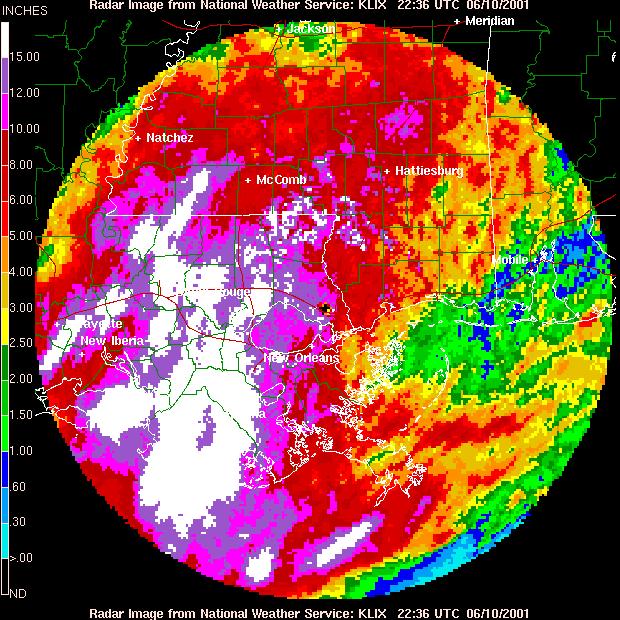
8 Typical values: stratiform rain Z = 200R 1.6 upslope rain Z = 31R 1.71 heavy convective rain Z = 486R 1.37 snow Z = 2000R 2 Example of radar-derived storm-total precipitation during storm in June 2001 along Gulf Coast. Polarization -- can also be very useful in determining rain rate, as drop shape varies with drop size (large drops flatten as they fall)
9
Lecture 19: Operational Remote Sensing in Visible, IR, and Microwave Channels
 MET 4994 Remote Sensing: Radar and Satellite Meteorology MET 5994 Remote Sensing in Meteorology Lecture 19: Operational Remote Sensing in Visible, IR, and Microwave Channels Before you use data from any
Meteorological Satellite Image Interpretations, Part III. Acknowledgement: Dr. S. Kidder at Colorado State Univ.
 Meteorological Satellite Image Interpretations, Part III Acknowledgement: Dr. S. Kidder at Colorado State Univ. Dates EAS417 Topics Jan 30 Introduction & Matlab tutorial Feb 1 Satellite orbits & navigation
Remote Sensing in Meteorology: Satellites and Radar. AT 351 Lab 10 April 2, Remote Sensing
 Remote Sensing in Meteorology: Satellites and Radar AT 351 Lab 10 April 2, 2008 Remote Sensing Remote sensing is gathering information about something without being in physical contact with it typically
Lecture 13. Applications of passive remote sensing: Remote sensing of precipitation and clouds.
 Lecture 13. Applications of passive remote sensing: Remote sensing of precipitation and clouds. 1. Classification of remote sensing techniques to measure precipitation. 2. Visible and infrared remote sensing
F O U N D A T I O N A L C O U R S E
 F O U N D A T I O N A L C O U R S E December 6, 2018 Satellite Foundational Course for JPSS (SatFC-J) F O U N D A T I O N A L C O U R S E Introduction to Microwave Remote Sensing (with a focus on passive
Snowfall Detection and Rate Retrieval from ATMS
 Snowfall Detection and Rate Retrieval from ATMS Jun Dong 1, Huan Meng 2, Cezar Kongoli 1, Ralph Ferraro 2, Banghua Yan 2, Nai-Yu Wang 1, Bradley Zavodsky 3 1 University of Maryland/ESSIC/Cooperative Institute
State of the art of satellite rainfall estimation
 State of the art of satellite rainfall estimation 3-year comparison over South America using gauge data, and estimates from IR, TRMM radar and passive microwave Edward J. Zipser University of Utah, USA
SNOWFALL RATE RETRIEVAL USING AMSU/MHS PASSIVE MICROWAVE DATA
 SNOWFALL RATE RETRIEVAL USING AMSU/MHS PASSIVE MICROWAVE DATA Huan Meng 1, Ralph Ferraro 1, Banghua Yan 2 1 NOAA/NESDIS/STAR, 5200 Auth Road Room 701, Camp Spring, MD, USA 20746 2 Perot Systems Government
Clouds, Precipitation and their Remote Sensing
 Clouds, Precipitation and their Remote Sensing Prof. Susanne Crewell AG Integrated Remote Sensing Institute for Geophysics and Meteorology University of Cologne Susanne Crewell, Kompaktkurs, Jülich 24.
MAIN ATTRIBUTES OF THE PRECIPITATION PRODUCTS DEVELOPED BY THE HYDROLOGY SAF PROJECT RESULTS OF THE VALIDATION IN HUNGARY
 MAIN ATTRIBUTES OF THE PRECIPITATION PRODUCTS DEVELOPED BY THE HYDROLOGY SAF PROJECT RESULTS OF THE VALIDATION IN HUNGARY Eszter Lábó OMSZ-Hungarian Meteorological Service, Budapest, Hungary labo.e@met.hu
Rain rate retrieval using the 183-WSL algorithm
 Rain rate retrieval using the 183-WSL algorithm S. Laviola, and V. Levizzani Institute of Atmospheric Sciences and Climate, National Research Council Bologna, Italy (s.laviola@isac.cnr.it) ABSTRACT High
Moisture, Clouds, and Precipitation: Clouds and Precipitation. Dr. Michael J Passow
 Moisture, Clouds, and Precipitation: Clouds and Precipitation Dr. Michael J Passow What Processes Lift Air? Clouds require three things: water vapor, a condensation nucleus, and cooling Cooling usually
Satellite derived precipitation estimates over Indian region during southwest monsoons
 J. Ind. Geophys. Union ( January 2013 ) Vol.17, No.1, pp. 65-74 Satellite derived precipitation estimates over Indian region during southwest monsoons Harvir Singh 1,* and O.P. Singh 2 1 National Centre
Lecture 4b: Meteorological Satellites and Instruments. Acknowledgement: Dr. S. Kidder at Colorado State Univ.
 Lecture 4b: Meteorological Satellites and Instruments Acknowledgement: Dr. S. Kidder at Colorado State Univ. US Geostationary satellites - GOES (Geostationary Operational Environmental Satellites) US
Lecture 4: Radiation Transfer
 Lecture 4: Radiation Transfer Spectrum of radiation Stefan-Boltzmann law Selective absorption and emission Reflection and scattering Remote sensing Importance of Radiation Transfer Virtually all the exchange
Rainfall estimation over the Taiwan Island from TRMM/TMI data
 P1.19 Rainfall estimation over the Taiwan Island from TRMM/TMI data Wann-Jin Chen 1, Ming-Da Tsai 1, Gin-Rong Liu 2, Jen-Chi Hu 1 and Mau-Hsing Chang 1 1 Dept. of Applied Physics, Chung Cheng Institute
Judit Kerényi. OMSZ-Hungarian Meteorological Service P.O.Box 38, H-1525, Budapest Hungary Abstract
 Comparison of the precipitation products of Hydrology SAF with the Convective Rainfall Rate of Nowcasting-SAF and the Multisensor Precipitation Estimate of EUMETSAT Judit Kerényi OMSZ-Hungarian Meteorological
Aviation Hazards: Thunderstorms and Deep Convection
 Aviation Hazards: Thunderstorms and Deep Convection TREND Diagnosis of thunderstorm hazards using imagery Contents Satellite imagery Visible, infrared, water vapour Basic cloud identification Identifying
The retrieval of the atmospheric humidity parameters from NOAA/AMSU data for winter season.
 The retrieval of the atmospheric humidity parameters from NOAA/AMSU data for winter season. Izabela Dyras, Bożena Łapeta, Danuta Serafin-Rek Satellite Research Department, Institute of Meteorology and
New capabilities with high resolution cloud micro-structure facilitated by MTG 2.3 um channel
 Slide 19 November 2016, V1.0 New capabilities with high resolution cloud micro-structure facilitated by MTG 2.3 um channel Author: Daniel Rosenfeld The Hebrew University of Jerusalem (HUJ) daniel.rosenfeld@huji.ac.il
Classification of hydrometeors using microwave brightness. temperature data from AMSU-B over Iran
 Iranian Journal of Geophysics, Vol. 9, No. 5, 2016, Page 24-39 Classification of hydrometeors using microwave brightness temperature data from AMSU-B over Iran Abolhasan Gheiby 1* and Majid Azadi 2 1 Assistant
Interpretation of Polar-orbiting Satellite Observations. Atmospheric Instrumentation
 Interpretation of Polar-orbiting Satellite Observations Outline Polar-Orbiting Observations: Review of Polar-Orbiting Satellite Systems Overview of Currently Active Satellites / Sensors Overview of Sensor
Climate Dynamics (PCC 587): Feedbacks & Clouds
: Feedbacks & Clouds") Climate Dynamics (PCC 587): Feedbacks & Clouds DARGAN M. W. FRIERSON UNIVERSITY OF WASHINGTON, DEPARTMENT OF ATMOSPHERIC SCIENCES DAY 6: 10-14-13 Feedbacks Climate forcings change global temperatures directly
Climate Dynamics (PCC 587): Feedbacks & Clouds DARGAN M. W. FRIERSON UNIVERSITY OF WASHINGTON, DEPARTMENT OF ATMOSPHERIC SCIENCES DAY 6: 10-14-13 Feedbacks Climate forcings change global temperatures directly
A New Microwave Snow Emissivity Model
 A New Microwave Snow Emissivity Model Fuzhong Weng 1,2 1. Joint Center for Satellite Data Assimilation 2. NOAA/NESDIS/Office of Research and Applications Banghua Yan DSTI. Inc The 13 th International TOVS
NWP SAF. Quantitative precipitation estimation from satellite data. Satellite Application Facility for Numerical Weather Prediction
 NWP SAF Satellite Application Facility for Numerical Weather Prediction Document NWPSAF-MO-VS-011 Version 1.0 15 April 2006 Quantitative precipitation estimation from satellite data Sante Laviola University
Snowfall Detection and Retrieval from Passive Microwave Satellite Observations. Guosheng Liu Florida State University
 Snowfall Detection and Retrieval from Passive Microwave Satellite Observations Guosheng Liu Florida State University Collaborators: Eun Kyoung Seo, Yalei You Snowfall Retrieval: Active vs. Passive CloudSat
ATMOS 5140 Lecture 1 Chapter 1
 ATMOS 5140 Lecture 1 Chapter 1 Atmospheric Radiation Relevance for Weather and Climate Solar Radiation Thermal Infrared Radiation Global Heat Engine Components of the Earth s Energy Budget Relevance for
Remote Sensing of Precipitation on the Tibetan Plateau Using the TRMM Microwave Imager
 AUGUST 2001 YAO ET AL. 1381 Remote Sensing of Precipitation on the Tibetan Plateau Using the TRMM Microwave Imager ZHANYU YAO Laboratory for Severe Storm Research, Department of Geophysics, Peking University,
On the Limitations of Satellite Passive Measurements for Climate Process Studies
 On the Limitations of Satellite Passive Measurements for Climate Process Studies Steve Cooper 1, Jay Mace 1, Tristan L Ecuyer 2, Matthew Lebsock 3 1 University of Utah, Atmospheric Sciences 2 University
Differences between East and West Pacific Rainfall Systems
 15 DECEMBER 2002 BERG ET AL. 3659 Differences between East and West Pacific Rainfall Systems WESLEY BERG, CHRISTIAN KUMMEROW, AND CARLOS A. MORALES Department of Atmospheric Science, Colorado State University,
APPENDIX 2 OVERVIEW OF THE GLOBAL PRECIPITATION MEASUREMENT (GPM) AND THE TROPICAL RAINFALL MEASURING MISSION (TRMM) 2-1
 AND THE TROPICAL RAINFALL MEASURING MISSION (TRMM) 2-1") APPENDIX 2 OVERVIEW OF THE GLOBAL PRECIPITATION MEASUREMENT (GPM) AND THE TROPICAL RAINFALL MEASURING MISSION (TRMM) 2-1 1. Introduction Precipitation is one of most important environmental parameters.
APPENDIX 2 OVERVIEW OF THE GLOBAL PRECIPITATION MEASUREMENT (GPM) AND THE TROPICAL RAINFALL MEASURING MISSION (TRMM) 2-1 1. Introduction Precipitation is one of most important environmental parameters.
A Microwave Snow Emissivity Model
 A Microwave Snow Emissivity Model Fuzhong Weng Joint Center for Satellite Data Assimilation NOAA/NESDIS/Office of Research and Applications, Camp Springs, Maryland and Banghua Yan Decision Systems Technologies
VALIDATION OF INSAT-3D DERIVED RAINFALL. (Submitted by Suman Goyal, IMD) Summary and Purpose of Document
 Summary and Purpose of Document") WORLD METEOROLOGICAL ORGANIZATION COMMISSION FOR BASIC SYSTEMS OPEN PROGRAMME AREA GROUP ON INTEGRATED OBSERVING SYSTEMS INTER-PROGRAMME EXPERT TEAM ON SATELLITE UTILIZATION AND PRODUCTS SECOND SESSION
WORLD METEOROLOGICAL ORGANIZATION COMMISSION FOR BASIC SYSTEMS OPEN PROGRAMME AREA GROUP ON INTEGRATED OBSERVING SYSTEMS INTER-PROGRAMME EXPERT TEAM ON SATELLITE UTILIZATION AND PRODUCTS SECOND SESSION
Advanced Satellite Remote Sensing: Microwave Remote Sensing. August 11, 2011
 Advanced Satellite Remote Sensing: Microwave Remote Sensing FIU HRSSERP Internship August 11, 2011 What can Microwave Satellites Measure? Ocean Surface Wind Speed SeaIce Concentration, Edge, and age Precipitation
School on Modelling Tools and Capacity Building in Climate and Public Health April Remote Sensing
 2453-5 School on Modelling Tools and Capacity Building in Climate and Public Health 15-26 April 2013 Remote Sensing CECCATO Pietro International Research Institute for Climate and Society, IRI The Earth
Studying snow cover in European Russia with the use of remote sensing methods
 40 Remote Sensing and GIS for Hydrology and Water Resources (IAHS Publ. 368, 2015) (Proceedings RSHS14 and ICGRHWE14, Guangzhou, China, August 2014). Studying snow cover in European Russia with the use
Christian Sutton. Microwave Water Radiometer measurements of tropospheric moisture. ATOC 5235 Remote Sensing Spring 2003
 Christian Sutton Microwave Water Radiometer measurements of tropospheric moisture ATOC 5235 Remote Sensing Spring 23 ABSTRACT The Microwave Water Radiometer (MWR) is a two channel microwave receiver used
Inner core dynamics: Eyewall Replacement and hot towers
 Inner core dynamics: Eyewall Replacement and hot towers FIU Undergraduate Hurricane Internship Lecture 4 8/13/2012 Why inner core dynamics is important? Current TC intensity and structure forecasts contain
Observations of Mediterranean Precipitating Systems using AMSU
 Observations of Mediterranean Precipitating Systems using AMSU Beatriz FUNATSU 1, Chantal CLAUD 1 and Jean-Pierre CHABOUREAU 2 1 Laboratoire de Meteorologie Dynamique/IPSL, Palaiseau 2 Laboratoire d Aerologie/CNRS-UPS,
Stratiform and Convective Classification of Rainfall Using SSM/I 85-GHz Brightness Temperature Observations
 570 JOURNAL OF ATMOSPHERIC AND OCEANIC TECHNOLOGY VOLUME 14 Stratiform and Convective Classification of Rainfall Using SSM/I 85-GHz Brightness Temperature Observations EMMANOUIL N. ANAGNOSTOU Department
Glaciology HEAT BUDGET AND RADIATION
 HEAT BUDGET AND RADIATION A Heat Budget 1 Black body radiation Definition. A perfect black body is defined as a body that absorbs all radiation that falls on it. The intensity of radiation emitted by a
The assimilation of AMSU and SSM/I brightness temperatures in clear skies at the Meteorological Service of Canada
 The assimilation of AMSU and SSM/I brightness temperatures in clear skies at the Meteorological Service of Canada Abstract David Anselmo and Godelieve Deblonde Meteorological Service of Canada, Dorval,
Remote sensing of ice clouds
 Remote sensing of ice clouds Carlos Jimenez LERMA, Observatoire de Paris, France GDR microondes, Paris, 09/09/2008 Outline : ice clouds and the climate system : VIS-NIR, IR, mm/sub-mm, active 3. Observing
Spaceborne and Ground-based Global and Regional Precipitation Estimation: Multi-Sensor Synergy
 Hydrometeorology and Remote Sensing Lab (hydro.ou.edu) at The University of Oklahoma Spaceborne and Ground-based Global and Regional Precipitation Estimation: Multi-Sensor Synergy Presented by: 温逸馨 (Berry)
The TRMM Precipitation Radar s View of Shallow, Isolated Rain
 OCTOBER 2003 NOTES AND CORRESPONDENCE 1519 The TRMM Precipitation Radar s View of Shallow, Isolated Rain COURTNEY SCHUMACHER AND ROBERT A. HOUZE JR. Department of Atmospheric Sciences, University of Washington,
A Time Lag Model to Estimate Rainfall Rate Based on GOES Data
 A Time Lag Model to Estimate Rainfall Rate Based on GOES Data Nazario D. Ramirez, Robert J. Kuligowski, and Joan M. Castro Octava Reunión Nacional de Percepción Remota y Sistemas Geográficos de Información
Characteristics of Global Precipitable Water Revealed by COSMIC Measurements
 Characteristics of Global Precipitable Water Revealed by COSMIC Measurements Ching-Yuang Huang 1,2, Wen-Hsin Teng 1, Shu-Peng Ho 3, Ying-Hwa Kuo 3, and Xin-Jia Zhou 3 1 Department of Atmospheric Sciences,
Journal of the Meteorological Society of Japan, Vol. 75, No. 1, pp , Day-to-Night Cloudiness Change of Cloud Types Inferred from
 Journal of the Meteorological Society of Japan, Vol. 75, No. 1, pp. 59-66, 1997 59 Day-to-Night Cloudiness Change of Cloud Types Inferred from Split Window Measurements aboard NOAA Polar-Orbiting Satellites
Day Microphysics RGB Nephanalysis in daytime. Meteorological Satellite Center, JMA
 Day Microphysics RGB Nephanalysis in daytime Meteorological Satellite Center, JMA What s Day Microphysics RGB? R : B04 (N1 0.86) Range : 0~100 [%] Gamma : 1.0 G : B07(I4 3.9) (Solar component) Range :
Monitoring Climate Change from Space
 Monitoring Climate Change from Space Richard Allan (email: r.p.allan@reading.ac.uk twitter: @rpallanuk) Department of Meteorology, University of Reading Why Monitor Earth s Climate from Space? Global Spectrum
Remote sensing of precipitation extremes
 The panel is about: Understanding and predicting weather and climate extreme Remote sensing of precipitation extremes Climate extreme : (JSC meeting, June 30 2014) IPCC SREX report (2012): Climate Ali
NEW SCHEME TO IMPROVE THE DETECTION OF RAINY CLOUDS IN PUERTO RICO
 NEW SCHEME TO IMPROVE THE DETECTION OF RAINY CLOUDS IN PUERTO RICO Joan Manuel Castro Sánchez Advisor Dr. Nazario Ramirez UPRM NOAA CREST PRYSIG 2016 October 7, 2016 Introduction A cloud rainfall event
Severe storms over the Mediterranean Sea: A satellite and model analysis
 National Research Council of Italy Severe storms over the Mediterranean Sea: A satellite and model analysis V. Levizzani, S. Laviola, A. Malvaldi, M. M. Miglietta, and E. Cattani 6 th International Precipitation
"Cloud and Rainfall Observations using Microwave Radiometer Data and A-priori Constraints" Christian Kummerow and Fang Wang Colorado State University
 "Cloud and Rainfall Observations using Microwave Radiometer Data and A-priori Constraints" Christian Kummerow and Fang Wang Colorado State University ECMWF-JCSDA Workshop Reading, England June 16-18, 2010
DERIVED FROM SATELLITE DATA
 P6.17 INTERCOMPARISON AND DIAGNOSIS OF MEI-YU RAINFALL DERIVED FROM SATELLITE DATA Y. Zhou * Department of Meteorology, University of Maryland, College Park, Maryland P. A. Arkin ESSIC, University of Maryland,
Retrieving Snowfall Rate with Satellite Passive Microwave Measurements
 Retrieving Snowfall Rate with Satellite Passive Microwave Measurements Huan Meng 1, Ralph Ferraro 1, Banghua Yan 1, Cezar Kongoli 2, Nai-Yu Wang 2, Jun Dong 2, Limin Zhao 1 1 NOAA/NESDIS, USA 2 Earth System
PARCWAPT Passive Radiometry Cloud Water Profiling Technique
 PARCWAPT Passive Radiometry Cloud Water Profiling Technique By: H. Czekala, T. Rose, Radiometer Physics GmbH, Germany A new cloud liquid water profiling technique by Radiometer Physics GmbH (patent pending)
MESO-NH cloud forecast verification with satellite observation
 MESO-NH cloud forecast verification with satellite observation Jean-Pierre CHABOUREAU Laboratoire d Aérologie, University of Toulouse and CNRS, France http://mesonh.aero.obs-mip.fr/chaboureau/ DTC Verification
Assimilation of precipitation-related observations into global NWP models
 Assimilation of precipitation-related observations into global NWP models Alan Geer, Katrin Lonitz, Philippe Lopez, Fabrizio Baordo, Niels Bormann, Peter Lean, Stephen English Slide 1 H-SAF workshop 4
NOAA/NESDIS Tropical Web Page with LEO Satellite Products and Applications for Forecasters
 NOAA/NESDIS Tropical Web Page with LEO Satellite Products and Applications for Forecasters Sheldon Kusselson National Oceanic and Atmospheric Administration (NOAA) National Environmental Satellite Data
Principles of Radiative Transfer Principles of Remote Sensing. Marianne König EUMETSAT
 - Principles of Radiative Transfer Principles of Remote Sensing Marianne König EUMETSAT marianne.koenig@eumetsat.int Remote Sensing All measurement processes which perform observations/measurements of
Recent improvements in the all-sky assimilation of microwave radiances at the ECMWF
 Recent improvements in the all-sky assimilation of microwave radiances at the ECMWF Katrin Lonitz, Alan Geer and many more katrin.lonitz@ecmwf.int ECMWF January 30, 2018 clear sky assimilation all-sky
MOISTURE PROFILE RETRIEVALS FROM SATELLITE MICROWAVE SOUNDERS FOR WEATHER ANALYSIS OVER LAND AND OCEAN
 MOISTURE PROFILE RETRIEVALS FROM SATELLITE MICROWAVE SOUNDERS FOR WEATHER ANALYSIS OVER LAND AND OCEAN John M. Forsythe, Stanley Q. Kidder, Andrew S. Jones and Thomas H. Vonder Haar Cooperative Institute
P4.4 THE COMBINATION OF A PASSIVE MICROWAVE BASED SATELLITE RAINFALL ESTIMATION ALGORITHM WITH AN IR BASED ALGORITHM
 P4.4 THE COMBINATION OF A PASSIVE MICROWAVE BASED SATELLITE RAINFALL ESTIMATION ALGORITHM WITH AN IR BASED ALGORITHM Robert Joyce 1), John E. Janowiak 2), and Phillip A. Arkin 3, Pingping Xie 2) 1) RS
Microphysical Properties of Single and Mixed-Phase Arctic Clouds Derived From Ground-Based AERI Observations
 Microphysical Properties of Single and Mixed-Phase Arctic Clouds Derived From Ground-Based AERI Observations Dave Turner University of Wisconsin-Madison Pacific Northwest National Laboratory 8 May 2003
11D.6 DIURNAL CYCLE OF TROPICAL DEEP CONVECTION AND ANVIL CLOUDS: GLOBAL DISTRIBUTION USING 6 YEARS OF TRMM RADAR AND IR DATA
 11D.6 DIURNAL CYCLE OF TROPICAL DEEP CONVECTION AND ANVIL CLOUDS: GLOBAL DISTRIBUTION USING 6 YEARS OF TRMM RADAR AND IR DATA 1. INTRODUCTION Before the launch of the TRMM satellite in late 1997, most
HY-2A Satellite User s Guide
 National Satellite Ocean Application Service 2013-5-16 Document Change Record Revision Date Changed Pages/Paragraphs Edit Description i Contents 1 Introduction to HY-2 Satellite... 1 2 HY-2 satellite data
On the Satellite Determination of Multilayered Multiphase Cloud Properties. Science Systems and Applications, Inc., Hampton, Virginia 2
 JP1.10 On the Satellite Determination of Multilayered Multiphase Cloud Properties Fu-Lung Chang 1 *, Patrick Minnis 2, Sunny Sun-Mack 1, Louis Nguyen 1, Yan Chen 2 1 Science Systems and Applications, Inc.,
Polar regions Temperate Regions Tropics High ( cirro ) 3-8 km 5-13 km 6-18 km Middle ( alto ) 2-4 km 2-7 km 2-8 km Low ( strato ) 0-2 km 0-2 km 0-2 km
 3-8 km 5-13 km 6-18 km Middle ( alto ) 2-4 km 2-7 km 2-8 km Low ( strato ) 0-2 km 0-2 km 0-2 km") Clouds and Climate Clouds (along with rain, snow, fog, haze, etc.) are wet atmospheric aerosols. They are made up of tiny spheres of water from 2-100 m which fall with terminal velocities of a few cm/sec.
Clouds and Climate Clouds (along with rain, snow, fog, haze, etc.) are wet atmospheric aerosols. They are made up of tiny spheres of water from 2-100 m which fall with terminal velocities of a few cm/sec.
The effect of ice fall speed in the structure of surface precipitation
 The effect of ice fall speed in the structure of surface precipitation 10th International SRNWP-Workshop on Non-Hydrostatic Modelling. 14 th May 2013 Jorge Bornemann, Paul Field, Kalli Furtado, Mark Weeks,
URSI-F Microwave Signatures Meeting 2010, Florence, Italy, October 4 8, Thomas Meissner Lucrezia Ricciardulli Frank Wentz
 URSI-F Microwave Signatures Meeting 2010, Florence, Italy, October 4 8, 2010 Wind Measurements from Active and Passive Microwave Sensors High Winds and Winds in Rain Thomas Meissner Lucrezia Ricciardulli
Variational Inversion of Hydrometeors Using Passive Microwave Sensors
 Variational Inversion of Hydrometeors Using Passive Microwave Sensors -Application to AMSU/MHS, SSMIS and ATMS- S.-A. Boukabara, F. Iturbide-Sanchez, R. Chen, W. Chen, K. Garrett, C. Grassotti F. Weng
A two-season impact study of the Navy s WindSat surface wind retrievals in the NCEP global data assimilation system
 A two-season impact study of the Navy s WindSat surface wind retrievals in the NCEP global data assimilation system Li Bi James Jung John Le Marshall 16 April 2008 Outline WindSat overview and working
Model errors in tropical cloud and precipitation revealed by the assimilation of MW imagery
 Model errors in tropical cloud and precipitation revealed by the assimilation of MW imagery Katrin Lonitz, Alan Geer, Philippe Lopez + many other colleagues 20 November 2014 Katrin Lonitz ( ) Tropical
Comparison of Diurnal Variation of Precipitation System Observed by TRMM PR, TMI and VIRS
 Comparison of Diurnal Variation of Precipitation System Observed by TRMM PR, TMI and VIRS Munehisa K. Yamamoto, Fumie A. Furuzawa 2,3 and Kenji Nakamura 3 : Graduate School of Environmental Studies, Nagoya
Direct assimilation of all-sky microwave radiances at ECMWF
 Direct assimilation of all-sky microwave radiances at ECMWF Peter Bauer, Alan Geer, Philippe Lopez, Deborah Salmond European Centre for Medium-Range Weather Forecasts Reading, Berkshire, UK Slide 1 17
For those 5 x5 boxes that are primarily land, AE_RnGd is simply an average of AE_Rain_L2B; the ensuing discussion pertains entirely to oceanic boxes.
 AMSR-E Monthly Level-3 Rainfall Accumulations Algorithm Theoretical Basis Document Thomas T. Wilheit Department of Atmospheric Science Texas A&M University 2007 For those 5 x5 boxes that are primarily
Climate & Earth System Science. Introduction to Meteorology & Climate. Chapter 05 SOME OBSERVING INSTRUMENTS. Instrument Enclosure.
 Climate & Earth System Science Introduction to Meteorology & Climate MAPH 10050 Peter Lynch Peter Lynch Meteorology & Climate Centre School of Mathematical Sciences University College Dublin Meteorology
Blackbody radiation. Main Laws. Brightness temperature. 1. Concepts of a blackbody and thermodynamical equilibrium.
 Lecture 4 lackbody radiation. Main Laws. rightness temperature. Objectives: 1. Concepts of a blackbody, thermodynamical equilibrium, and local thermodynamical equilibrium.. Main laws: lackbody emission:
A statistical approach for rainfall confidence estimation using MSG-SEVIRI observations
 A statistical approach for rainfall confidence estimation using MSG-SEVIRI observations Elisabetta Ricciardelli*, Filomena Romano*, Nico Cimini*, Frank Silvio Marzano, Vincenzo Cuomo* *Institute of Methodologies
Basic cloud Interpretation using Satellite Imagery
 Basic cloud Interpretation using Satellite Imagery Introduction Recall that images from weather satellites are actually measurements of energy from specified bands within the Electromagnetic (EM) spectrum.
Observations needed for verification of additional forecast products
 Observations needed for verification of additional forecast products Clive Wilson ( & Marion Mittermaier) 12th Workshop on Meteorological Operational Systems, ECMWF, 2-6 November 2009 Additional forecast
Masahiro Kazumori, Takashi Kadowaki Numerical Prediction Division Japan Meteorological Agency
 Development of an all-sky assimilation of microwave imager and sounder radiances for the Japan Meteorological Agency global numerical weather prediction system Masahiro Kazumori, Takashi Kadowaki Numerical
THE EUMETSAT MULTI-SENSOR PRECIPITATION ESTIMATE (MPE)
") THE EUMETSAT MULTI-SENSOR PRECIPITATION ESTIMATE (MPE) Thomas Heinemann, Alessio Lattanzio and Fausto Roveda EUMETSAT Am Kavalleriesand 31, 64295 Darmstadt, Germany ABSTRACT The combination of measurements
THE EUMETSAT MULTI-SENSOR PRECIPITATION ESTIMATE (MPE) Thomas Heinemann, Alessio Lattanzio and Fausto Roveda EUMETSAT Am Kavalleriesand 31, 64295 Darmstadt, Germany ABSTRACT The combination of measurements
Lecture 9: Climate Sensitivity and Feedback Mechanisms
 Lecture 9: Climate Sensitivity and Feedback Mechanisms Basic radiative feedbacks (Plank, Water Vapor, Lapse-Rate Feedbacks) Ice albedo & Vegetation-Climate feedback Cloud feedback Biogeochemical feedbacks
Arctic Clouds and Radiation Part 2
 Arctic Clouds and Radiation Part 2 Glen Lesins Department of Physics and Atmospheric Science Dalhousie University Create Summer School, Alliston, July 2013 No sun Arctic Winter Energy Balance 160 W m -2
Fluid Circulation Review. Vocabulary. - Dark colored surfaces absorb more energy.
 Fluid Circulation Review Vocabulary Absorption - taking in energy as in radiation. For example, the ground will absorb the sun s radiation faster than the ocean water. Air pressure Albedo - Dark colored
REMOTE SENSING OF THE ATMOSPHERE AND OCEANS
 EAS 6145 SPRING 2007 REMOTE SENSING OF THE ATMOSPHERE AND OCEANS Instructor: Prof. Irina N. Sokolik office 2258, phone 404-894-6180 isokolik@eas.gatech.edu Meeting Time: Mondays: 3:05-4:25 PM Wednesdays:
THE FEASIBILITY OF EXTRACTING LOWLEVEL WIND BY TRACING LOW LEVEL MOISTURE OBSERVED IN IR IMAGERY OVER CLOUD FREE OCEAN AREA IN THE TROPICS
 THE FEASIBILITY OF EXTRACTING LOWLEVEL WIND BY TRACING LOW LEVEL MOISTURE OBSERVED IN IR IMAGERY OVER CLOUD FREE OCEAN AREA IN THE TROPICS Toshiro Ihoue and Tetsuo Nakazawa Meteorological Research Institute
A NEW METHOD OF RETRIEVAL OF WIND VELOCITY OVER THE SEA SURFACE IN TROPICAL CYCLONES OVER THE DATA OF MICROWAVE MEASUREMENTS. A.F.
 A NEW METHOD OF RETRIEVAL OF WIND VELOCITY OVER THE SEA SURFACE IN TROPICAL CYCLONES OVER THE DATA OF MICROWAVE MEASUREMENTS A.F. Nerushev Institute of Experimental Meteorology. 82 Lenin Ave., Obninsk,
A MODEL IN SPATIAL AND TEMPORAL DOMAIN TO PREDICT RADAR RAINFALL DATA
 A MODEL IN SPATIAL AND TEMPORAL DOMAIN TO PREDICT RADAR RAINFALL DATA Nazario D. Ramirez-Beltran, Luz Torres Molina, Joan M. Castro, Sandra Cruz-Pol, José G. Colom-Ustáriz and Nathan Hosanna PRYSIG 2014
Topic # 11 HOW CLIMATE WORKS continued (Part II) pp in Class Notes
 pp in Class Notes") Topic # 11 HOW CLIMATE WORKS continued (Part II) pp 61-67 in Class Notes To drive the circulation, the initial source of energy is from the Sun: Not to scale! EARTH- SUN Relationships 4 Things to Know
Topic # 11 HOW CLIMATE WORKS continued (Part II) pp 61-67 in Class Notes To drive the circulation, the initial source of energy is from the Sun: Not to scale! EARTH- SUN Relationships 4 Things to Know
Condensing Massive Satellite Datasets For Rapid Interactive Analysis
 Condensing Massive Satellite Datasets For Rapid Interactive Analysis Glenn Grant University of Colorado, Boulder With: David Gallaher 1,2, Qin Lv 1, G. Campbell 2, Cathy Fowler 2, Qi Liu 1, Chao Chen 1,
Diurnal cycles of precipitation, clouds, and lightning in the tropics from 9 years of TRMM observations
 GEOPHYSICAL RESEARCH LETTERS, VOL. 35, L04819, doi:10.1029/2007gl032437, 2008 Diurnal cycles of precipitation, clouds, and lightning in the tropics from 9 years of TRMM observations Chuntao Liu 1 and Edward
Description of Precipitation Retrieval Algorithm For ADEOS II AMSR
 Description of Precipitation Retrieval Algorithm For ADEOS II Guosheng Liu Florida State University 1. Basic Concepts of the Algorithm This algorithm is based on Liu and Curry (1992, 1996), in which the
The Climate System and Climate Models. Gerald A. Meehl National Center for Atmospheric Research Boulder, Colorado
 The Climate System and Climate Models Gerald A. Meehl National Center for Atmospheric Research Boulder, Colorado The climate system includes all components of the physical earth system that affect weather
P1.20 MICROWAVE LAND EMISSIVITY OVER COMPLEX TERRAIN: APPLIED TO TEMPERATURE PROFILING WITH NOGAPS ABSTRACT
 P1.0 MICROWAVE LAND EMISSIVITY OVER COMPLEX TERRAIN: APPLIED TO TEMPERATURE PROFILING WITH NOGAPS Benjamin Ruston *1, Thomas Vonder Haar 1, Andrew Jones 1, and Nancy Baker 1 Cooperative Institute for Research
Temp 54 Dew Point 41 Relative Humidity 63%
 Temp 54 Dew Point 41 Relative Humidity 63% Water in the Atmosphere Evaporation Water molecules change from the liquid to gas phase Molecules in liquids move slowly Heat energy makes them move faster When
8.2 Numerical Study of Relationships between Convective Vertical Velocity, Radar Reflectivity Profiles, and Passive Microwave Brightness Temperatures
 8.2 Numerical Study of Relationships between Convective Vertical Velocity, Radar Reflectivity Profiles, and Passive Microwave Brightness Temperatures Yaping Li, Edward J. Zipser, Steven K. Krueger, and
Satellite and Aircraft Observations of Snowfall Signature at Microwave Frequencies. Yoo-Jeong Noh and Guosheng Liu
 Satellite and Aircraft Observations of Snowfall Signature at Microwave Frequencies Yoo-Jeong Noh and Guosheng Liu Department of Meteorology, Florida State University Tallahassee, Florida, USA Corresponding