0-6 hour Weather Forecast Guidance at The Weather Company. Steven Honey, Joseph Koval, Cathryn Meyer, Peter Neilley The Weather Company
|
|
|
- Tobias Griffith
- 6 years ago
- Views:
Transcription

1 1 0-6 hour Weather Forecast Guidance at The Weather Company Steven Honey, Joseph Koval, Cathryn Meyer, Peter Neilley The Weather Company


2 TWC Forecasts: Widespread Adoption 2
3 0-6 Hour Forecast Details 3 Global coverage 15-minute precision for forecasts of: Precipitation: Type, Accumulation and Probability Temperature Cloud Cover Government Warning Information Forecasts updated every 5 min using latest radar and NWP data Alerting capability for start of precipitation and Warnings


4 How are 0-6 hr forecasts built? 4 Integrate radar data into mosaic Manual QC Automated QC + Time Synchronization 5m Mosaics Motion Vectors Public Forecast and Alerts TOR/SVR Update HOTL Fcster edits Forward Err. Correction of T, Td, Wind T, Td, vis, mslp, rh Blend POP QPE 0-7 hr Radar Forecast Global + Regional NWP 1-15 day multi-model ensemble blend

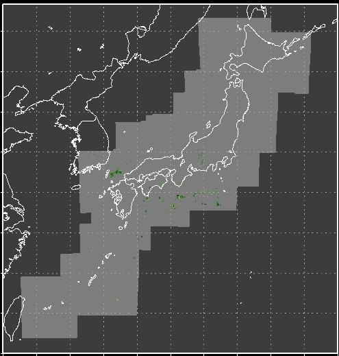
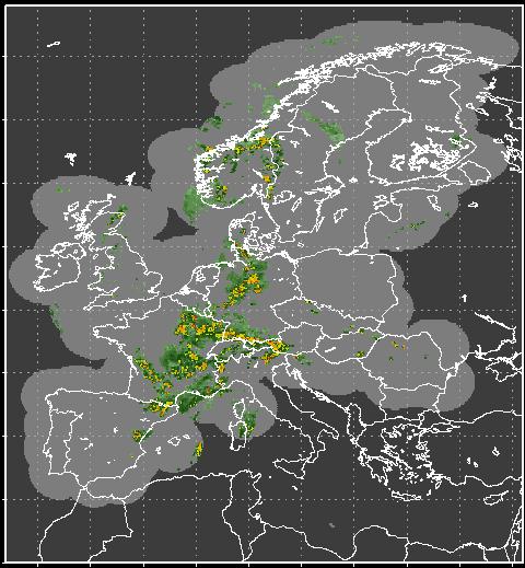
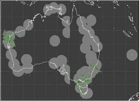
5 Radar Processing: TWC Global Coverage 5
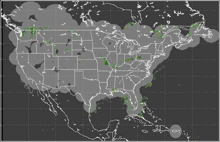
6 Radar Processing: TWC NOWRad Coverage 6

7 Radar Processing: Extrapolation 7 Radar extrapolated out to 7 hours Radar motion detected by tracking cells in subsequent radar mosaics Extrapolation forward in time using a backward semi-lagrangian advection scheme
8 Deep Thunder: TWC Numerical Weather Prediction 8 13km Global, 6-hour updates 4km Regional with 3 and 1-hour updates
9 Radar + NWP Blending 9 Temporal Blend of radar extrapolated and NWP forecasts with weight as a f(forecast time, prob thunder) Assumption is that precipitation motion and initiation is more linear when non-convective High Prob Thunder Radar -> NWP Low Prob Thunder Radar -> NWP Fcst time (0->360min) Fcst time (0->360min) Currently working to incorporate more advanced blending algorithms


10 Probability of Precipitation 10 POP is critical to TWC Consumer Forecasts: 30-39%: Isolated Showers 40-59%: Scattered Showers >60%: Rain How do we get probability from deterministic nowcasts?

11 Probability of Precipitation: Radar Extrapolation 11 Intensity-weighted spatial analysis at each grid point Example: 20 km box on 4km grid = Coverage * Weighted Intensity = 0.80 * 325 / 500 = 52% POP Analysis box increases from 12 km to 40 km between 0 and 2 hours, then remains constant to 7 hours 0 hr: 100% 1 hr: 91% 2 hr: 79%
12 Probability of Precip: NWP Time Lagged Ensemble Spatial POP calculated for all NWP forecasts using a 40km box 2. Weighted average of spatial POP from all forecasts with lead time <= 8 hours 3. Calculated every 15 min between now and 9 hours from now 4:2 Weights for recent runs 4:4:3:3:2:2:2 4:2 4:3:2


13 Probability of Precip: NWP Time Lagged Ensemble 13 Contour: POP Shaded: Blended radar + model precipitation rate forecast Spatial Only Spatial + TLE
14 Probability of Precipitation: Blend 14 Temporally blend the Radar extrapolated POP and the NWP (time-lagged ensemble) POP, in same way that precipitation rate is blended High Prob Thunder Radar -> NWP Low Prob Thunder Radar -> NWP Fcst time (0->360min) Fcst time (0->360min)

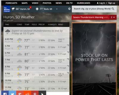
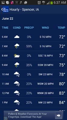
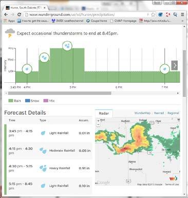
15 Putting it all together 15 Deterministic precipitation accumulation (shaded) Probabilistic Occurrence (contour) Observed POP KNYC Forecast Public Forecast hr Acc(mm) POP Worded Forecast Cloudy Scattered Strong Storms Scattered Strong Storms Strong Storms Thunderstorms Scattered Thunderstorms Scattered Thunderstorms

16 Radar + NWP: 6-hour Precipitation Forecasts 16

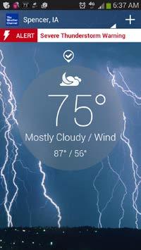
17 Government Issued Warnings 17 TOR/SVR Warning promote textual forecasts NOWCAST Without Warning: Expect occasional thunderstorms to end at 3:30pm. NOWCAST When SVR Warning is issued: Showers and thunderstorms ending around 3:30pm. Some of the storms could be severe.
18 Looking ahead 18 Acquire more radar data to expand radar coverage We will use other sources (satellite, lightning) to enhance initial precipitation analysis Parameters will become dynamic Temporal blending weights Spatial analysis size Time-lagged ensemble weightings Alternative methods for deriving POP from radar extrapolation Spatial phase correction applied to model Intensity correction applied to model
19 Looking Ahead days ending 23 July 2016 United States Domain 0.05 /hr, 1.27 mm/hr Operational Radar Extrap Operational NWP Research: Laterally Corrected Blended Courtesy James Pinto, NCAR
Update on CoSPA Storm Forecasts
 Update on CoSPA Storm Forecasts Haig August 2, 2011 This work was sponsored by the Federal Aviation Administration under Air Force Contract No. FA8721-05-C-0002. Opinions, interpretations, conclusions,
Strategic Radar Enhancement Project (SREP) Forecast Demonstration Project (FDP) The future is here and now
 Forecast Demonstration Project (FDP) The future is here and now") Strategic Radar Enhancement Project (SREP) Forecast Demonstration Project (FDP) The future is here and now Michael Berechree National Manager Aviation Weather Services Australian Bureau of Meteorology
Strategic Radar Enhancement Project (SREP) Forecast Demonstration Project (FDP) The future is here and now Michael Berechree National Manager Aviation Weather Services Australian Bureau of Meteorology
Probabilistic Quantitative Precipitation Forecasts for Tropical Cyclone Rainfall
 Probabilistic Quantitative Precipitation Forecasts for Tropical Cyclone Rainfall WOO WANG CHUN HONG KONG OBSERVATORY IWTCLP-III, JEJU 10, DEC 2014 Scales of Atmospheric Systems Advection-Based Nowcasting
Utilising Radar and Satellite Based Nowcasting Tools for Aviation Purposes in South Africa. Erik Becker
 Utilising Radar and Satellite Based Nowcasting Tools for Aviation Purposes in South Africa Erik Becker Morné Gijben, Mary-Jane Bopape, Stephanie Landman South African Weather Service: Nowcasting and Very
A new mesoscale NWP system for Australia
 A new mesoscale NWP system for Australia www.cawcr.gov.au Peter Steinle on behalf of : Earth System Modelling (ESM) and Weather&Environmental Prediction (WEP) Research Programs, CAWCR Data Assimilation
CONTRIBUTION OF ENSEMBLE FORECASTING APPROACHES TO FLASH FLOOD NOWCASTING AT GAUGED AND UNGAUGED CATCHMENTS
 CONTRIBUTION OF ENSEMBLE FORECASTING APPROACHES TO FLASH FLOOD NOWCASTING AT GAUGED AND UNGAUGED CATCHMENTS Maria-Helena Ramos 1, Julie Demargne 2, Pierre Javelle 3 1. Irstea Antony, 2. Hydris Hydrologie,
QPE and QPF in the Bureau of Meteorology
 QPE and QPF in the Bureau of Meteorology Current and future real-time rainfall products Carlos Velasco (BoM) Alan Seed (BoM) and Luigi Renzullo (CSIRO) OzEWEX 2016, 14-15 December 2016, Canberra Why do
Seamless nowcasting. Open issues
 Federal Department of Home Affairs FDHA Federal Office of Meteorology and Climatology MeteoSwiss Seamless nowcasting INCA Open issues Pierre Eckert Matteo Buzzi, Marco Sassi, Guido della Bruna, Marco Gaia
On the use of radar rainfall estimates and nowcasts in an operational heavy rainfall warning service
 On the use of radar rainfall estimates and nowcasts in an operational heavy rainfall warning service Alan Seed, Ross Bunn, Aurora Bell Bureau of Meteorology Australia The Centre for Australian Weather
Nowcasting techniques in use for severe weather operation in NMC/CMA
 WWRP NMRWG Buenos Aires Aug 2017 Nowcasting techniques in use for severe weather operation in NMC/CMA Jianjie WANG National Meteorological Center, CMA Cascading Weather Forecasting Process --- different
Emerging Aviation Weather Research at MIT Lincoln Laboratory*
 Emerging Aviation Weather Research at MIT Lincoln Laboratory* Haig 19 November 2015 *This work was sponsored by the Federal Aviation Administration under Air Force Contract No. FA8721-05-C-0002. Opinions,
Introduction to NCEP's time lagged North American Rapid Refresh Ensemble Forecast System (NARRE-TL)
") Introduction to NCEP's time lagged North American Rapid Refresh Ensemble Forecast System (NARRE-TL) Binbin Zhou 1,2, Jun Du 2, Geoff Manikin 2 & Geoff DiMego 2 1. I.M. System Group 2. EMC/NCEP/NWS/NOAA
Introduction to NCEP's time lagged North American Rapid Refresh Ensemble Forecast System (NARRE-TL) Binbin Zhou 1,2, Jun Du 2, Geoff Manikin 2 & Geoff DiMego 2 1. I.M. System Group 2. EMC/NCEP/NWS/NOAA
FAA Weather Research Plans
 FAA Weather Research Plans Presented to: Friends /Partners in Aviation Weather Vision Forum By: Ray Moy FAA Aviation Weather Office Date: Aviation Weather Research Program (AWRP) Purpose: Applied Research
The Nowcasting Demonstration Project for London 2012
 The Nowcasting Demonstration Project for London 2012 Susan Ballard, Zhihong Li, David Simonin, Jean-Francois Caron, Brian Golding, Met Office, UK Introduction The success of convective-scale NWP is largely
Bruce L. Rose The Weather Channel Atlanta, GA. and. Peter P. Neilley 1 Weather Services International, Inc. Andover, MA 01810
 7.20 A Real-Time System to Estimate Weather Conditions at High Resolution Bruce L. Rose The Weather Channel Atlanta, GA and Peter P. Neilley 1 Weather Services International, Inc. Andover, MA 01810 1.
Developments towards multi-model based forecast product generation
 Developments towards multi-model based forecast product generation Ervin Zsótér Methodology and Forecasting Section Hungarian Meteorological Service Introduction to the currently operational forecast production
icast: A Severe Thunderstorm Forecasting, Nowcasting and Alerting Prototype Focused on Optimization of the Human-Machine Mix
 icast: A Severe Thunderstorm Forecasting, Nowcasting and Alerting Prototype Focused on Optimization of the Human-Machine Mix 1Cloud Physics and Severe Weather Research Section, Toronto, ON 2Meteorological
NOAA s Severe Weather Forecasting System: HRRR to WoF to FACETS
 NOAA s Severe Weather Forecasting System: HRRR to WoF to FACETS David D NOAA / Earth System Research Laboratory / Global Systems Division Nowcasting and Mesoscale Research Working Group Meeting World Meteorological
Aurora Bell*, Alan Seed, Ross Bunn, Bureau of Meteorology, Melbourne, Australia
 15B.1 RADAR RAINFALL ESTIMATES AND NOWCASTS: THE CHALLENGING ROAD FROM RESEARCH TO WARNINGS Aurora Bell*, Alan Seed, Ross Bunn, Bureau of Meteorology, Melbourne, Australia 1. Introduction Warnings are
Convection Nowcasting Products Available at the Army Test and Evaluation Command (ATEC) Ranges
 Ranges") Convection Nowcasting Products Available at the Army Test and Evaluation Command (ATEC) Ranges Cathy Kessinger National Center for Atmospheric Research (NCAR), Boulder, CO with contributions from: Wiebke
Convection Nowcasting Products Available at the Army Test and Evaluation Command (ATEC) Ranges Cathy Kessinger National Center for Atmospheric Research (NCAR), Boulder, CO with contributions from: Wiebke
STEPS-BE: an ensemble radar rainfall nowcasting system for urban hydrology in Belgium
 STEPS-BE: an ensemble radar rainfall nowcasting system for urban hydrology in Belgium Loris Foresti 1,2, Maarten Reyniers 2, Lesley De Cruz 2, Alan Seed 3 and Laurent Delobbe 2 with contributions from
Generating probabilistic forecasts from convectionpermitting. Nigel Roberts
 Generating probabilistic forecasts from convectionpermitting ensembles Nigel Roberts Context for this talk This is the age of the convection-permitting model ensemble Met Office: MOGREPS-UK UK 2.2km /12
Reprint 797. Development of a Thunderstorm. P.W. Li
 Reprint 797 Development of a Thunderstorm Nowcasting System in Support of Air Traffic Management P.W. Li AMS Aviation, Range, Aerospace Meteorology Special Symposium on Weather-Air Traffic Management Integration,
Research on Lightning Nowcasting and Warning System and Its Application
 Research on Lightning Nowcasting and Warning System and Its Application Wen Yao Chinese Academy of Meteorological Sciences Beijing, China yaowen@camscma.cn 2016.07 1 CONTENTS 1 2 3 4 Lightning Hazards
Weather Products for Decision Support Tools Joe Sherry April 10, 2001
 Weather Products for Decision Support Tools Joe Sherry National Convective Weather Forecast (NCWF) Computer generated graphical forecast extending 0-1 hours, updated every 5 minutes Conservative forecast
WG4: interpretation and applications
 Federal Department of Home Affairs FDHA Federal Office of Meteorology and Climatology MeteoSwiss WG4: interpretation and applications Pierre Eckert MeteoSwiss, Geneva Topics FIELDEXTRA presentation by
The next generation in weather radar software.
 The next generation in weather radar software. PUBLISHED BY Vaisala Oyj Phone (int.): +358 9 8949 1 P.O. Box 26 Fax: +358 9 8949 2227 FI-00421 Helsinki Finland Try IRIS Focus at iris.vaisala.com. Vaisala
Auto-Nowcast System Tom Saxen (July) Huaqing Cai (Aug) National Center for Atmospheric Research
 Huaqing Cai (Aug) National Center for Atmospheric Research") Auto-Nowcast System Tom Saxen (July) Huaqing Cai (Aug) National Center for Atmospheric Research Summer 2006 ATEC Forecaster Conference Photo courtesy of Greg Thompson Overview: Introductory comments on
Auto-Nowcast System Tom Saxen (July) Huaqing Cai (Aug) National Center for Atmospheric Research Summer 2006 ATEC Forecaster Conference Photo courtesy of Greg Thompson Overview: Introductory comments on
Unit 5 Lesson 3 How is Weather Predicted? Copyright Houghton Mifflin Harcourt Publishing Company
 Tracking the Weather Warm up 1 Why is it important to watch the weather forecast before traveling to another country? Tracking the Weather A meteorologist is a scientist who studies weather. Meteorologists
Xinhua Liu National Meteorological Center (NMC) of China Meteorological Administration (CMA)
 of China Meteorological Administration (CMA)") The short-time forecasting and nowcasting technology of severe convective weather for aviation meteorological services in China Xinhua Liu National Meteorological Center (NMC) of China Meteorological Administration
The short-time forecasting and nowcasting technology of severe convective weather for aviation meteorological services in China Xinhua Liu National Meteorological Center (NMC) of China Meteorological Administration
NOWCASTING SYSTEMS AND SERVICES IN HONG KONG
 NOWCASTING SYSTEMS AND SERVICES IN HONG KONG Ping-Wah Peter LI Hong Kong Observatory, Aviation Weather Services Branch - Radar and Satellite Meteorology Division 3rd WMO/WWRP International Symposium on
Recent progress in radar-based rainfall observations over Belgium. PLURISK Final Symposium Brussels, 4 October 2017
 Recent progress in radar-based rainfall observations over Belgium Laurent Delobbe Royal Meteorological Institute of Belgium with contributions from Lesley De Cruz, Loris Foresti, Edouard Goudenhoofdt,
The importance of satellite data for nowcasting in the WWRP strategy
 The importance of satellite data for nowcasting in the WWRP strategy Estelle de Coning and Paolo Ruti World Weather Research Division Steve Goodman Chief Program Scientist, NOAA WMO definition Nowcasting
Concepts of Forecast Verification FROST-14
 Concepts of Forecast Verification FROST-14 Forecast & Research Olympics Sochi Testbed Pertti Nurmi WWRP JWGFVR Finnish Meteorological Institute pertti.nurmi@fmi.fi pertti.nurmi@fmi.fi FROST-14 Verification
Introduction. Sunny Partly Cloudy Cloudy. Flurries Snow Ice. Showers Thunderstorms Rain. High Pressure Low Pressure FRONTS. Cold Warm Stationary
 Introduction Weather can change from minute to minute, hour to hour, day to day, or season to season. Meteorologists are scientists who study Earth s atmosphere in order to predict these changes. Meteorologists
Information Note on the Webpage for Significant Convection Monitoring and Forecast
 Information Note on the Webpage for Significant Convection Monitoring and Forecast The webpage displays both the real-time products for monitoring of significant convection and forecast products for significant
New Meteorological Services Supporting ATM
 New Meteorological Services Supporting ATM Meteorological Services in the Terminal Area (MSTA)...providing MET services to support a move from Air Traffic Control (ATC) to more integrated and collaborative
Convective-scale NWP for Singapore
 Convective-scale NWP for Singapore Hans Huang and the weather modelling and prediction section MSS, Singapore Dale Barker and the SINGV team Met Office, Exeter, UK ECMWF Symposium on Dynamical Meteorology
Aircraft-based Observations: Impact on weather forecast model performance
 Aircraft-based Observations: Impact on weather forecast model performance Stephen S. Weygandt Eric James, Stan Benjamin, Bill Moninger, Brian Jamison, Geoff Manikin* NOAA Earth System Research Laboratory
Research on Experiment of Lightning Nowcasting and Warning System in Electric Power Department of HeNan
 Research on Experiment of Lightning Nowcasting and Warning System in Electric Power Department of HeNan Ning Zhou 1) 周宁 Zhe LI 1) 李哲 Wen YAO 2) 姚雯 Qing MENG 2) 孟青 1) State Grid Henan Electric Power Research
Application of Nowcast Products to Real-time Warning of Hazardous Weather in Hong Kong
 Application of Nowcast Products to Real-time Warning of Hazardous Weather in Hong Kong M.C. Wong, E.S.T. Lai and P.W. Li Hong Kong Observatory, Hong Kong, China 1. INTRODUCTION Severe weather events may
Improving real time observation and nowcasting RDT. E de Coning, M Gijben, B Maseko and L van Hemert Nowcasting and Very Short Range Forecasting
 Improving real time observation and nowcasting RDT E de Coning, M Gijben, B Maseko and L van Hemert Nowcasting and Very Short Range Forecasting Introduction Satellite Application Facilities (SAFs) are
B.W.Golding * Met Office, Exeter, UK
 7.35 A NEW APPROACH TO NOWCASTING AT THE MET OFFICE B.W.Golding * Met Office, Exeter, UK 1. BACKGROUND * The Nimrod system was introduced into operational use in the Met Office in 1996 (Golding, 1998).
SWAN The Operational System for Nowcasting and Very-short Range Forecast in CMA
 SWAN The Operational System for Nowcasting and Very-short Range Forecast in CMA National Meteorological Center (NMC) China Meteorological Administration (CMA) Mao Dongyan, Zheng Yuanyuan, Zhou Kanghui
Consolidated Storm Prediction for Aviation (CoSPA) Overview
 Overview") Consolidated Storm Prediction for Aviation (CoSPA) Overview Ray Moy (FAA), Bill Dupree (MIT LL Lead), and Matthias Steiner (NCAR Lead) 27 September 2007 NBAA User Panel Review - 1 Consolidated Storm Prediction
Consolidated Storm Prediction for Aviation (CoSPA) Overview Ray Moy (FAA), Bill Dupree (MIT LL Lead), and Matthias Steiner (NCAR Lead) 27 September 2007 NBAA User Panel Review - 1 Consolidated Storm Prediction
Heavy Rainfall Event of June 2013
 Heavy Rainfall Event of 10-11 June 2013 By Richard H. Grumm National Weather Service State College, PA 1. Overview A 500 hpa short-wave moved over the eastern United States (Fig. 1) brought a surge of
Thunderstorm Forecasting and Warnings in the US: Applications to the Veneto Region
 Thunderstorm Forecasting and Warnings in the US: Applications to the Veneto Region Bill Conway Vice President Weather Decision Technologies Norman, Oklahoma, USA Andrea Rossa ARPAV Lead Scientist Centre
Development of new products by operational forecasters
 Development of new products by operational forecasters Probability of Thunder -algorithm Paavo Korpela Operational meteorologist & developer Safety Weather Centre Finnish Meteorological Institute Content
FPAW October Pat Murphy & David Bright NWS Aviation Weather Center
 FPAW October 2014 Pat Murphy & David Bright NWS Aviation Weather Center Overview Ensemble & Probabilistic Forecasts What AWC Is Doing Now Ensemble Processor What s In Development (NOAA Aviation Weather
TIFS DEVELOPMENTS INSPIRED BY THE B08 FDP. John Bally, A. J. Bannister, and D. Scurrah Bureau of Meteorology, Melbourne, Victoria, Australia
 P13B.11 TIFS DEVELOPMENTS INSPIRED BY THE B08 FDP John Bally, A. J. Bannister, and D. Scurrah Bureau of Meteorology, Melbourne, Victoria, Australia 1. INTRODUCTION This paper describes the developments
P1.10 Synchronization of Multiple Radar Observations in 3-D Radar Mosaic
 Submitted for the 12 th Conf. on Aviation, Range, and Aerospace Meteor. 29 Jan. 2 Feb. 2006. Atlanta, GA. P1.10 Synchronization of Multiple Radar Observations in 3-D Radar Mosaic Hongping Yang 1, Jian
Verifying Ensemble Forecasts Using A Neighborhood Approach
 Verifying Ensemble Forecasts Using A Neighborhood Approach Craig Schwartz NCAR/MMM schwartz@ucar.edu Thanks to: Jack Kain, Ming Xue, Steve Weiss Theory, Motivation, and Review Traditional Deterministic
SPC Ensemble Applications: Current Status and Future Plans
 : Current Status and Future Plans Israel Jirak Science Support Branch Storm Prediction Center Norman, OK Acknowledgments: Steve Weiss, Andy Dean, Gregg Grosshans, and Chris Melick Outline Large-Scale Guidance:
Weather Hazard Modeling Research and development: Recent Advances and Plans
 Weather Hazard Modeling Research and development: Recent Advances and Plans Stephen S. Weygandt Curtis Alexander, Stan Benjamin, Geoff Manikin*, Tanya Smirnova, Ming Hu NOAA Earth System Research Laboratory
Convective-scale Warn-on-Forecast The Future of Severe Weather Warnings in the USA?
 Convective-scale Warn-on-Forecast The Future of Severe Weather Warnings in the USA? David J. Stensrud Department of Meteorology The Pennsylvania State University Present Warning System: 2 March 2012 Warning
Techniques of Severe Convective Weather Comprehensive Monitoring
 Techniques of Severe Convective Weather Comprehensive Monitoring Yongguang Zheng, Lin Yinjing, Zhu Wenjian, Lan Yu, Tang Wenyuan, Zhang Xiaoling, Mao Dongyan, Zhou Qingliang, Zhang Zhigang Severe Weather
 Identification of Predictors for Nowcasting Heavy Rainfall In Taiwan --------------------- Part II: Storm Characteristics and Nowcasting Applications Challenges in Developing Nowcasting Applications for
Add NOAA nowcoast Layers to Maps
 WebEOC Maps Add-on Quick Reference Guide Add NOAA nowcoast Layers to Maps Overview With Maps Add-on, you can configure an unlimited number of map layers. These layers allow you to control the data you
Evaluation of Ensemble Icing Probability Forecasts in NCEP s SREF, VSREF and NARRE-TL Systems
 Evaluation of Ensemble Icing Probability Forecasts in NCEP s, V and Systems Binbin Zhou 1,2, Jun Du 2, Geoff DeMigo 2 and Robert Sallee 3 1. I.M. System Group 2. Environmental Modeling Center of NCEP 3.
DATA FUSION NOWCASTING AND NWP
 DATA FUSION NOWCASTING AND NWP Brovelli Pascal 1, Ludovic Auger 2, Olivier Dupont 1, Jean-Marc Moisselin 1, Isabelle Bernard-Bouissières 1, Philippe Cau 1, Adrien Anquez 1 1 Météo-France Forecasting Department
Seamless Probabilistic Forecasts for Civil Protection: from week to minutes
 Seamless Probabilistic Forecasts for Civil Protection: from week to minutes Yong Wang, Clemens Wastl, Andre Simon, Mihaly Szűcs ZAMG and HMS An EU project Bridging of Probabilistic Forecasts and Civil
Aviation Hazards: Thunderstorms and Deep Convection
 Aviation Hazards: Thunderstorms and Deep Convection TREND NWP Products for Thunderstorm Forecasting Contents Model choice Identifying parameters important for convection: Low-level convergence High relative
Hazard assessment based on radar-based rainfall nowcasts at European scale The HAREN project
 Hazard assessment based on radar-based rainfall nowcasts at European scale The HAREN project Marc Berenguer, Daniel Sempere-Torres 3 OPERA radar mosaic OPERA radar mosaic: 213919 133 Precipitation observations
HRRR and the Mid-Mississippi Valley Severe and Heavy rainfall event of October 2014
 HRRR and the Mid-Mississippi Valley Severe and Heavy rainfall event of 13-14 October 2014 By Richard H. Grumm National Weather Service State College, PA contributions by Charles Ross 1. Overview A deep
At the start of the talk will be a trivia question. Be prepared to write your answer.
 Operational hydrometeorological forecasting activities of the Australian Bureau of Meteorology Thomas Pagano At the start of the talk will be a trivia question. Be prepared to write your answer. http://scottbridle.com/
Assimilation of precipitation-related observations into global NWP models
 Assimilation of precipitation-related observations into global NWP models Alan Geer, Katrin Lonitz, Philippe Lopez, Fabrizio Baordo, Niels Bormann, Peter Lean, Stephen English Slide 1 H-SAF workshop 4
Khalid Y. Muwembe UGANDA NATIONAL METEOROLOGICAL AUTHORITY (UNMA)
") Forecasting Severe Weather over Lake Victoria region in Uganda Khalid Y. Muwembe UGANDA NATIONAL METEOROLOGICAL AUTHORITY (UNMA) Outline Background Set-up of forecasting/alert service Diurnal circulation
Forecasting Severe Weather over Lake Victoria region in Uganda Khalid Y. Muwembe UGANDA NATIONAL METEOROLOGICAL AUTHORITY (UNMA) Outline Background Set-up of forecasting/alert service Diurnal circulation
7.17 RAPIDS A NEW RAINSTORM NOWCASTING SYSTEM IN HONG KONG
 7.17 RAPIDS A NEW RAINSTORM NOWCASTING SYSTEM IN HONG KONG Li Ping-Wah *, Wong Wai-Kin and Edwin S.T. Lai Hong Kong Observatory, 134A Nathan Road, Kowloon, Hong Kong 1. INTRODUCTION and the numerical forecast
Nowcasting thunderstorms for aeronautical end-users
 Nowcasting thunderstorms for aeronautical end-users Jean-Marc Moisselin Météo-France, Nowcasting Department co-authors: Céline Jauffret (Météo-France) Overview Introduction SAT RADAR NWP image crédit:
Merging Rain-Gauge and Radar Data
 Merging Rain-Gauge and Radar Data Dr Sharon Jewell, Obserations R&D, Met Office, FitzRoy Road, Exeter sharon.jewell@metoffice.gov.uk Outline 1. Introduction The Gauge and radar network Interpolation techniques
Progress in Aviation Weather Forecasting for ATM Decision Making FPAW 2010
 Progress in Aviation Weather Forecasting for ATM Decision Making FPAW 2010 Jim Evans Marilyn Wolfson 21 October 2010-1 Overview (1) Integration with storm avoidance models and ATC route usage models (2)
MSG FOR NOWCASTING - EXPERIENCES OVER SOUTHERN AFRICA
 MSG FOR NOWCASTING - EXPERIENCES OVER SOUTHERN AFRICA Estelle de Coning and Marianne König South African Weather Service, Private Bag X097, Pretoria 0001, South Africa EUMETSAT, Am Kavalleriesand 31, D-64295
Communicating uncertainty from short-term to seasonal forecasting
 Communicating uncertainty from short-term to seasonal forecasting MAYBE NO YES Jay Trobec KELO-TV Sioux Falls, South Dakota USA TV weather in the US Most TV weather presenters have university degrees and
JOINT WMO TECHNICAL PROGRESS REPORT ON THE GLOBAL DATA PROCESSING AND FORECASTING SYSTEM AND NUMERICAL WEATHER PREDICTION RESEARCH ACTIVITIES FOR 2006
 JOINT WMO TECHNICAL PROGRESS REPORT ON THE GLOBAL DATA PROCESSING AND FORECASTING SYSTEM AND NUMERICAL WEATHER PREDICTION RESEARCH ACTIVITIES FOR 2006 HUNGARIAN METEOROLOGICAL SERVICE 1. Summary of highlights
Weather Unit Part 2: Meteorology
 Name: Earth Science Date: Period: Weather Unit Part 2: Meteorology 1 The map below shows North America and its surrounding bodies of water. Country borders are shown. On the map, label the following locations:
Hail nowcast exploiting radar and satellite observations
 Federal Department of Home Affairs FDHA Federal Office of Meteorology and Climatology MeteoSwiss Hail nowcast exploiting radar and satellite observations Ulrich Hamann, Elena Leonarduzzi, Kristopher Bedka,
Project AutoWARN. Automatic Support for the Weather Warning Service at DWD
 Automatic Support for the Weather Warning Service at DWD Bernhard Reichert Deutscher Wetterdienst, Referat FE ZE Email: bernhard.reichert@dwd.de Content Project AutoWARN Introduction and Overview AutoWARN
Recent Developments of the NinJo Workstation
 Recent Developments of the NinJo Workstation Gerhard Eymann, DWD, FEZE gerhard.eymann@dwd.de 13 th Workshop on Meteorological Operational Systems ECMWF Reading, UK Oct. 31 - Nov. 4, 2011 Selected Recent
Verification of ensemble and probability forecasts
 Verification of ensemble and probability forecasts Barbara Brown NCAR, USA bgb@ucar.edu Collaborators: Tara Jensen (NCAR), Eric Gilleland (NCAR), Ed Tollerud (NOAA/ESRL), Beth Ebert (CAWCR), Laurence Wilson
Verification of nowcasts and short-range forecasts, including aviation weather
 Verification of nowcasts and short-range forecasts, including aviation weather Barbara Brown NCAR, Boulder, Colorado, USA WMO WWRP 4th International Symposium on Nowcasting and Very-short-range Forecast
An Algorithm to Identify and Track Objects on Spatial Grids
 An Algorithm to Identify and Track Objects on Spatial Grids VA L L I A P PA L A K S H M A N A N N AT I O N A L S E V E R E S T O R M S L A B O R AT O R Y / U N I V E R S I T Y O F O K L A H O M A S E P,
Figure 5: Comparison between SAFIR warning and radar-based hail detection for the hail event of June 8, 2003.
 SAFIR WARNING : Expected risk Radar-based Probability of Hail 0915 0930 0945 1000 Figure 5: Comparison between SAFIR warning and radar-based hail detection for the hail event of June 8, 2003. Lightning
Improving Reservoir Management Using the Storm Precipitation Analysis System (SPAS) and NEXRAD Weather Radar
 and NEXRAD Weather Radar") Improving Reservoir Management Using the Storm Precipitation Analysis System (SPAS) and NEXRAD Weather Radar Bill D. Kappel, Applied Weather Associates, LLC, Monument, CO Edward M. Tomlinson, Ph.D., Applied
Improving Reservoir Management Using the Storm Precipitation Analysis System (SPAS) and NEXRAD Weather Radar Bill D. Kappel, Applied Weather Associates, LLC, Monument, CO Edward M. Tomlinson, Ph.D., Applied
National Convective Weather Forecasts Cindy Mueller
 National Convective Weather Forecasts Cindy Mueller National Center for Atmospheric Research Research Applications Program National Forecast Demonstration 2-4-6 hr Convection Forecasts Collaborative forecast
1. Current atmospheric DA systems 2. Coupling surface/atmospheric DA 3. Trends & ideas
 1 Current issues in atmospheric data assimilation and its relationship with surfaces François Bouttier GAME/CNRM Météo-France 2nd workshop on remote sensing and modeling of surface properties, Toulouse,
Application of NWP products and meteorological information processing system in Hong Kong
 Application of NWP products and meteorological information processing system in Hong Kong Y.S. Li Scientific Officer Hong Kong Observatory (ysli@hko.gov.hk) 7 million people Hong Kong ~1,100 km sq. Regional
Use of radar to detect weather
 2 April 2007 Welcome to the RAP Advisory Panel Meeting Use of radar to detect weather G. Brant Foote Brant Director Foote Rita Roberts Roelof Bruintjes Research Applications Program Radar principles Radio
Enhancing The Delivery Of Weather & Climate Information To End-Users. by Meteorological Services Division, NEA, Singapore
 Enhancing The Delivery Of Weather & Climate Information To End-Users by Meteorological Services Division, NEA, Singapore WMO RA V Seminar on Enhancing Service Delivery Kuala Lumpur, Malaysia, 2-6 April
May 17, earthsciencechapter24.notebook. Apr 8 10:54 AM Review. Grade:9th. Subject:Earth Science. Date:4/8.
 Apr 8 10:54 AM 24.1 Review Grade:9th Subject:Earth Science Date:4/8 Apr 8 9:29 AM 1 1 As lower layers of air are warmed... A the air rises B winds form C the air dries D the air sinks Apr 8 9:49 AM 2 What
Nesting and LBCs, Predictability and EPS
 Nesting and LBCs, Predictability and EPS Terry Davies, Dynamics Research, Met Office Nigel Richards, Neill Bowler, Peter Clark, Caroline Jones, Humphrey Lean, Ken Mylne, Changgui Wang copyright Met Office
118 RECONSTRUCTION OF RADAR RFLECTIVITY IN CLUTTER AREAS
 8 RECONSTRUCTION OF RADAR RFLECTIVITY IN CLUTTER AREAS Shinju Park, Marc Berenguer Centre de Recerca Aplicada en Hidrometeorologia, Universitat Politècnica de Catalunya (BarcelonaTech), Barcelona, Spain..
The next generation in weather radar software.
 The next generation in weather radar software. PUBLISHED BY Vaisala Oyj Phone (int.): +358 9 8949 1 P.O. Box 26 Fax: +358 9 8949 2227 FI-00421 Helsinki Finland Try IRIS Focus at iris.vaisala.com. Vaisala
Computing urban wind fields
 Combining mesoscale, nowcast, and CFD model output in near real-time for protecting urban areas and buildings from releases of hazardous airborne materials S. Swerdlin, T. Warner, J. Copeland, D. Hahn,
A 21st century HRRR-based approach to estimating probable maximum precipitation to enhance dam safety and community resilience
 30 May 2017 FIRO Science Task Group Workshop A 21st century HRRR-based approach to estimating probable maximum precipitation to enhance dam safety and community resilience Courtesy Bill McCormick, Chief,
Weather Forecasting. March 26, 2009
 Weather Forecasting Chapter 13 March 26, 2009 Forecasting The process of inferring weather from a blend of data, understanding, climatology, and solutions of the governing equations Requires an analysis
J. William Conway, Beth Clarke, Chris Porter, Michael D. Eilts
 P 4(4) THE HYDROMET DECISION SUPPORT SYSTEM: TECHNOLOGY TRANSFER FROM RESEACH TO INTERNATIONAL OPERATIONS J. William Conway, Beth Clarke, Chris Porter, Michael D. Eilts Weather Decision Technologies, Inc.
Preliminary assessment of LAWR performance in tropical regions with high intensity convective rainfall
 Preliary assessment of LAWR performance in tropical regions with high intensity convective rainfall Chris Nielsen: DHI Water and Environment (Malaysia), Fanny Dugelay, Universitéde Nice Sophia Antipolis,
*Corresponding author address: Charles Barrere, Weather Decision Technologies, 1818 W Lindsey St, Norman, OK
 P13R.11 Hydrometeorological Decision Support System for the Lower Colorado River Authority *Charles A. Barrere, Jr. 1, Michael D. Eilts 1, and Beth Clarke 2 1 Weather Decision Technologies, Inc. Norman,
Predicting rainfall using ensemble forecasts
 Predicting rainfall using ensemble forecasts Nigel Roberts Met Office @ Reading MOGREPS-UK Convection-permitting 2.2 km ensemble now running routinely Embedded within MOGREPS-R ensemble members (18 km)
Nowcasting of Severe Weather from Satellite Images (for Southern
 Nowcasting of Severe Weather from Satellite Images (for Southern Europe) Petra Mikuš Jurković Forecasting/ nowcasting of convective storms NWP models cannot well predict the exact location and intesity