Nowcasting of Severe Weather from Satellite Images (for Southern
|
|
|
- Loren Clarke
- 6 years ago
- Views:
Transcription

 Petra Mikuš")
1 Nowcasting of Severe Weather from Satellite Images (for Southern Europe) Petra Mikuš Jurković
2 Forecasting/ nowcasting of convective storms NWP models cannot well predict the exact location and intesity of convective storms Thunderstorms often produce large hail, severe wind, strong rain, tornadous, lightning For detection and monitoring of convection forecasters often use remote sensing data satellite, radar and lightning data
 Mature convective storms Providing information about cloud tops process useful to estimate")
3 Benefits of using satellite imagery min Courtesy: John Mecikalski to 75 min Pre-convective environment Providing information on the preconvective envirnment, identify general air mass properties Convective initiation Identify the convective initiation phase (before they are seen on radar) Mature convective storms Providing information about cloud tops process useful to estimate storm severity
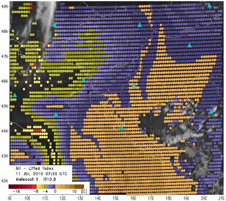
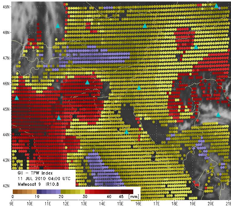
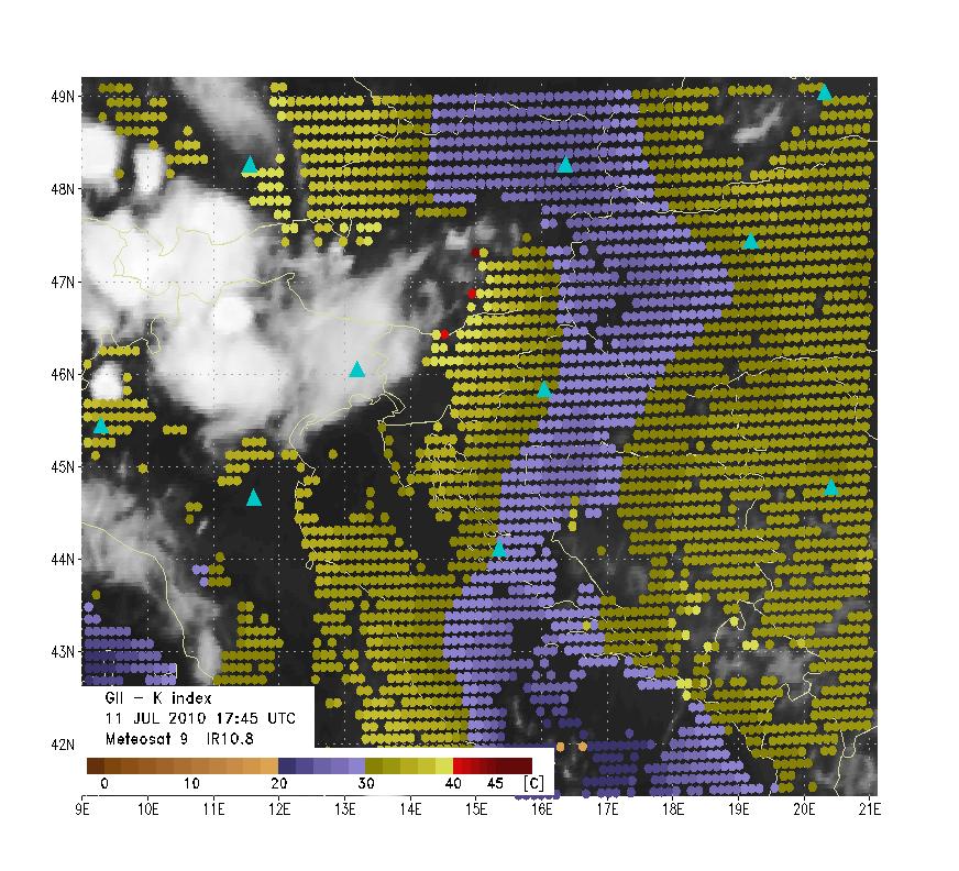
4 Pre-convective environment Instability indices derived from satellite data (MPEF GII Global Instability Index) K Index (KI) KO Index (KO) Lifted Index (LI) Total Precipitable Water (TPW) Indicate the location with high potentional for convection development Usually describe a temperature or moisture differences between atmospheric levels Only possible over clear sky!!!

5 Physical Retrieval GII algorithm Optimal estimation algoritham NWP PROFILES SEVIRI RTTOV T 0 (p),q 0 (p) T 1 (p),q 1 (p) T n (p),q n (p) WV 6.2 WV 7.3 Bias correction Tb SEVIRI Tb RTTOV Tb SEVIRI - Tb RTTOV <threshold? IR 10.8 IR 12.0 IR 13.4 YES T 0 (p),q 0 (p) NO OPTIMAL ESTIMATION ALGORITHM

6 Courtesy: Ivan Smiljanić

7 Courtesy: Ivan Smiljanić

8 False alarm at the cloud edges retrievels is contaminated by non-detected clouds or cloud edges better spatial resolution provide more precise values of instability indices K - Index The high values of K- Index is produced by cloud contaminated pixels Courtesy: Marianne König
9 Convective initiation Interest fields Physical basis (Mecikalski et al., 2010) Critical value 10.8 µm TB Cloud-top height/glaciation K 10.8 µm TB 15 min trend Cloud growth rate 50-5 C 10.8 µm TB 30 min trend Cloud growth rate <15 min cooling µm difference Breaking of capping inversion/cloud depth 15-0 C µm difference Cloud height relative to dry air aloft 25-0 C µm 15 min trend Cloud growth towards dry air aloft 3-30 C µm difference Cloud-top glaciation 10-0 C µm30 min trend Cloud-top glaciation growth 1-10 C µm difference Height relative to mid- to upper-troposphere C µm 15 min trend Cloud growth toward mid- to uppertroposphere µm 30 min trend Cloud growth toward mid- to uppertroposphere Tri-channel difference [( )-( )] Cloud-top glaciation C C 10-0 C Tri-channel 15 min trend Cloud-top glaciation growth C Tri-channel 30 min trend Cloud-top glaciation growth 1-10 C Critical values is not fixed need to be regionally tunned Courtesy: J. Mecikalski; Z. Kocsis

10 several pixels were detected with CI algorithm later a severe convective system was formed Day microphisic RGB orange colours small particles at the top indicate strong updraft Courtesy: Maria Putsay


11 Rapid developing thunderstorms (RDT) online, every 3 hours The output products life cycle stage: triggering growing trajectory of the system expected move for the next hour mature dissipating

12 Severe storms RGB R = WV6.2 - WV7.3 G = IR3.9 - IR10.8 B = NIR1.6 - VIS0.6 Convection monitoring and identifing CBs with small or large ice particles cold storms with small ice particles strong updraft cold Cbs with large ice particles normal updraft


")
13 HRV Severe Storms RGB OT, small ice particles, strong updraft ; 14:30 UTC Thick Ice Cloud (large ice) Thick Ice Cloud (small ice)
 maximum kinetic energy of the hailstones > 200 J/m 2 causes heavy damages to all")
14 1 2 2 Courtesy: Daniel Rosenfeld Very strong updraft small ice particles yellowish colors in RGB images Distribution of hailstone maximum sizes and kinetic energy very large hailstones (20 25 mm) maximum kinetic energy of the hailstones > 200 J/m 2 causes heavy damages to all plants


15 Mature convective storms HRVIS usefull information about storm top processes Overshooring tops IR 10.8 µm

16 Sandwich product IR 10.8 micron blended by HRV image (Setvak et al, 2010)
 COLD RING")

17 OTs, cold ring and cold U/V are often associated with severe weather at the ground heavy rain, large hail, severe wind, tornadous CENTRAL WARM SPOT (CWS) COLD RING DISTANT WARM AREA (DWA) CLOSE-IN WARM AREA (CWA) COLD U Courtesy: Martin Setvak Very good indicator that some severe weather conditions could be expected Not a prove of the severity!

18 2.5 minute MSG rapid scan experiments to better understand storm top processes preparation for the MTG better temporal and spatial resolution can improve detection of potentionaly dengerous convective cells The Meteosat minute rapid scan sessions: 17 May June June July 2013 Storms over northeast Italy: 12 September 2012, 06:00 08:55 UTC Meteosat-10 (MSG-3) experiment
")


19 HRV IR10.8 BT ( K) sandwich HRV & Storm RGB sandwich HRV & IR10.8 BT Courtesy: Martin Setvak
20 :37UTC
21 :40UTC

22 :42UTC
23 :45UTC
24 :47UTC
25 :50UTC
26 :52UTC
27 :55UTC
28 :57UTC
29 :00UTC
30 :02UTC
31 :05UTC
32 :07UTC
33 :10UTC
34 :12UTC
35 :15UTC
36 :17UTC
37 :20UTC
38 :22UTC
39 :25UTC
40 :27UTC
41 :30UTC
42 :32UTC
43 :35UTC
44 :37UTC
45 :40UTC
46 :42UTC
47 :45UTC
48 :47UTC
49 :50UTC
50 :52UTC
51 :55UTC
52 :57UTC
53 :00UTC
54 :02UTC
55 :05UTC
56 :07UTC
57 :10UTC
58 :12UTC
59 :15UTC
60 :17UTC
61 :20UTC
62 :22UTC
63 :25UTC
64 :27UTC
65 :30UTC
66 :32UTC
67 :35UTC
68 :37UTC
69 :40UTC
70 :42UTC
71 :45UTC
72 :47UTC
73 :50UTC
74 :52UTC
75 :55UTC

76 Thank you!!!
MSG FOR NOWCASTING - EXPERIENCES OVER SOUTHERN AFRICA
 MSG FOR NOWCASTING - EXPERIENCES OVER SOUTHERN AFRICA Estelle de Coning and Marianne König South African Weather Service, Private Bag X097, Pretoria 0001, South Africa EUMETSAT, Am Kavalleriesand 31, D-64295
SATELLITE MONITORING OF THE CONVECTIVE STORMS
 SATELLITE MONITORING OF THE CONVECTIVE STORMS FORECASTERS POINT OF VIEW Michaela Valachová, EUMETSAT Workshop at ECMWF User Meeting Reading, 13 June 2017 Central Forecasting Office, Prague michaela.valachova@chmi.cz
REPORT ON THE ACTIVITIES OF THE EUMETSAT-ESSL CONVECTION WORKING GROUP
 REPORT ON THE ACTIVITIES OF THE EUMETSAT-ESSL CONVECTION WORKING GROUP Marianne König EUMETSAT, Eumetsat Allee 1, 64295 Darmstadt, Germany Abstract The focus of the Convection Working Group is to have
Improving real time observation and nowcasting RDT. E de Coning, M Gijben, B Maseko and L van Hemert Nowcasting and Very Short Range Forecasting
 Improving real time observation and nowcasting RDT E de Coning, M Gijben, B Maseko and L van Hemert Nowcasting and Very Short Range Forecasting Introduction Satellite Application Facilities (SAFs) are
PRECONVECTIVE SOUNDING ANALYSIS USING IASI AND MSG- SEVIRI
 PRECONVECTIVE SOUNDING ANALYSIS USING IASI AND MSG- SEVIRI Marianne König, Dieter Klaes EUMETSAT, Eumetsat-Allee 1, 64295 Darmstadt, Germany Abstract EUMETSAT operationally generates the Global Instability
Rapidly Developing Thunderstorm (RDT)
") Rapidly Developing Thunderstorm (RDT) Jean-Marc Moisselin, Frédéric Autones Météo-France Nowcasting Department 42, av. Gaspard Coriolis 31057 Toulouse France jean-marc.moisselin@meteo.fr EUMETRAIN Convection
Rapidly Developing Thunderstorm (RDT) Jean-Marc Moisselin, Frédéric Autones Météo-France Nowcasting Department 42, av. Gaspard Coriolis 31057 Toulouse France jean-marc.moisselin@meteo.fr EUMETRAIN Convection
"Experiences with use of EUMETSAT MPEF GII product for convection/storm nowcasting"
 "Experiences with use of EUMETSAT MPEF GII product for convection/storm nowcasting" Marianne König 1, Monika Pajek 2, Piotr Struzik 2 1) EUMETSAT 2) Institute of Meteorology and Water Management, Kraków,
METEOSAT CONVECTIVE INITIATION PRODUCT WITH AND WITHOUT CLOUD TRACKING - EXPERIENCES
 METEOSAT CONVECTIVE INITIATION PRODUCT WITH AND WITHOUT CLOUD TRACKING - EXPERIENCES Mária Putsay 1, Zsófia Kocsis 1, Marianne König 2, Ildikó Szenyán 1, Márta Diószeghy 1, André Simon 1 and Márk Rajnai
Detection and Monitoring Convective Storms by. Using MSG SEVIRI Image. Aydın Gürol ERTÜRK. Contents
 Detection and Monitoring Convective Storms by 1 Using MSG SEVIRI Image Contents MSGView Software Cold U/V and Ring Shape Storm Tops Case Study, 2nd April 2011 Antalya, Türkiye Conclusion Aydın Gürol ERTÜRK
RGB Experts and Developers Workshop 2017 Tokyo, Japan
 "Application of the Sandwich Product and variations to this as used by Australian Forecasters and as presented during training at the Australian VLab Centre of Excellence". RGB Experts and Developers Workshop
Hail nowcast exploiting radar and satellite observations
 Federal Department of Home Affairs FDHA Federal Office of Meteorology and Climatology MeteoSwiss Hail nowcast exploiting radar and satellite observations Ulrich Hamann, Elena Leonarduzzi, Kristopher Bedka,
RDT-CW: TOWARD A MULTIDIMENSIONAL DESCRIPTION OF CONVECTION
 RDT-CW: TOWARD A MULTIDIMENSIONAL DESCRIPTION OF CONVECTION Jean-Marc Moisselin, Frederic Autonès Météo-France, DPREVI/PI, 42 avenue G. Coriolis 31057 Toulouse, France Abstract RDT-CW (Rapid Development
Satellite-based Convection Nowcasting and Aviation Turbulence Applications
 Satellite-based Convection Nowcasting and Aviation Turbulence Applications Kristopher Bedka Cooperative Institute for Meteorological Satellite Studies (CIMSS), University of Wisconsin-Madison In collaboration
YELLOW SPOT IN THE CONVECTIVE STORMS RGB IMAGE CAUSED BY A PILEUS CLOUD
 YELLOW SPOT IN THE CONVECTIVE STORMS RGB IMAGE CAUSED BY A PILEUS CLOUD André Simon, Mária Putsay, Ildikó Szenyán and Ákos Horváth Hungarian Meteorological Service, Kitaibel Pál u. 1, H-1024 Budapest,
Satellite-based thunderstorm tracking, monitoring and nowcasting over South Africa
 Satellite-based thunderstorm tracking, monitoring and nowcasting over South Africa Caroline Forster 1, Estelle de Coning 2, Sebastian Diebel 1, Tobias Zinner 3 EUMETSAT Meteorological Satellite Conference
CASE STUDY OF THE 20 MAY 2008 TORNADIC STORM IN HUNGARY
 CASE STUDY OF THE 20 MAY 2008 TORNADIC STORM IN HUNGARY Mária Putsay 1, Jochen Kerkmann 2 and Ildikó Szenyán 1 1 Hungarian Meteorological Service, H-1525 Budapest, P. O. Box 38, Hungary 2 EUMETSAT, am
TOPICS: What are Thunderstorms? Ingredients Stages Types Lightning Downburst and Microburst
 THUNDERSTORMS TOPICS: What are Thunderstorms? Ingredients Stages Types Lightning Downburst and Microburst What are Thunderstorms? A storm produced by a cumulonimbus cloud that contains lightning and thunder
For the operational forecaster one important precondition for the diagnosis and prediction of
 Initiation of Deep Moist Convection at WV-Boundaries Vienna, Austria For the operational forecaster one important precondition for the diagnosis and prediction of convective activity is the availability
CHARACTERISATION OF STORM SEVERITY BY USE OF SELECTED CONVECTIVE CELL PARAMETERS DERIVED FROM SATELLITE DATA
 CHARACTERISATION OF STORM SEVERITY BY USE OF SELECTED CONVECTIVE CELL PARAMETERS DERIVED FROM SATELLITE DATA Piotr Struzik Institute of Meteorology and Water Management, Satellite Remote Sensing Centre
INTERPRETATION OF MSG IMAGES, PRODUCTS AND SAFNWC OUTPUTS FOR DUTY FORECASTERS
 INTERPRETATION OF MSG IMAGES, PRODUCTS AND SAFNWC OUTPUTS FOR DUTY FORECASTERS M. Putsay, M. Rajnai, M. Diószeghy, J. Kerényi, I.G. Szenyán and S. Kertész Hungarian Meteorological Service, H-1525 Budapest,
Early detection of thunderstorms using satellite, radar and
 Federal Department of Home of Home Affairs Affairs FDHA FDHA Federal Office of of Meteorology and and Climatology MeteoSwiss Early detection of thunderstorms using satellite, radar and Observing convection
RGB Experts and Developers Workshop - Introduction Tokyo, Japan 7-9 Nov 2017
 RGB Experts and Developers Workshop - Introduction Tokyo, Japan 7-9 Nov 2017 Workshop Objectives Review of existing RGB standards Reconfirm and extend existing standards (new multi-spectral imagers) Stimulate
Page 1/8 Long duration validation of PGE11. SAF - Nowcasting Product Assessment Review Worshop (Madrid ctober 2005
 Page 1/8 Plan Research activity (visiting scientist: Oleksiy Kryvobok) Use of other PGEs and HRVis for RDT improvement Tuning PGE11 satellite-based discrimination using SEVIRI data Long duration validation
COLD-RING AND COLD-U/V SHAPED STORMS
 MARTIN SETVÁK setvak@chmi.cz Czech Hydrometeorological Institute, Prague COLD-RING AND COLD-U/V SHAPED STORMS Version : 18 May 2009 What are the cold-ring and cold-u/v shaped storms? Appearance and terminology
AOMSUC-6 Training Event
 Effective use of high temporal and spatial resolution Himawari-8 data AOMSUC-6 Training Event Bodo Zeschke Australian Bureau of Meteorology Training Centre Australian VLab Centre of Excellence Content
Severe storms over the Mediterranean Sea: A satellite and model analysis
 National Research Council of Italy Severe storms over the Mediterranean Sea: A satellite and model analysis V. Levizzani, S. Laviola, A. Malvaldi, M. M. Miglietta, and E. Cattani 6 th International Precipitation
MSGVIEW: AN OPERATIONAL AND TRAINING TOOL TO PROCESS, ANALYZE AND VISUALIZATION OF MSG SEVIRI DATA
 MSGVIEW: AN OPERATIONAL AND TRAINING TOOL TO PROCESS, ANALYZE AND VISUALIZATION OF MSG SEVIRI DATA Aydın Gürol Ertürk Turkish State Meteorological Service, Remote Sensing Division, CC 401, Kalaba Ankara,
Warning procedures for extreme events in the Emilia-Romagna Region
 Warning procedures for extreme events in the Emilia-Romagna Region Anna Fornasiero, Miria Celano, Roberta Amorati, Virginia Poli and Pier Paolo Alberoni Arpa Emilia-Romagna Hydro-Meteo-Climate Service,
Nowcasting thunderstorms for aeronautical end-users
 Nowcasting thunderstorms for aeronautical end-users Jean-Marc Moisselin Météo-France, Nowcasting Department co-authors: Céline Jauffret (Météo-France) Overview Introduction SAT RADAR NWP image crédit:
NOWCASTING PRODUCTS BASED ON MTSAT-1R RAPID SCAN OBSERVATION. In response to CGMS Action 38.33
 CGMS-39, JMA-WP-08 Prepared by JMA Agenda Item: G.II/8 Discussed in WG II NOWCASTING PRODUCTS BASED ON MTSAT-1R RAPID SCAN OBSERVATION In response to CGMS Action 38.33 This document reports on JMA s MTSAT-1R
RGB Products: an easy and practical way to display multispectral satellite data (in combination with derived products)
") RGB Products: an easy and practical way to display multispectral satellite data (in combination with derived products) Dr. Jochen Kerkmann Training Officer EUMETSAT Multi-channel GEO satellites today Him-08
RGB Products: an easy and practical way to display multispectral satellite data (in combination with derived products) Dr. Jochen Kerkmann Training Officer EUMETSAT Multi-channel GEO satellites today Him-08
Global Instability Index: Product Guide
 Doc.No. Issue : : EUM/TSS/MAN/15/802106 v1c e-signed EUMETSAT Eumetsat-Allee 1, D-64295 Darmstadt, Germany Tel: +49 6151 807-7 Fax: +49 6151 807 555 Date : 2 September 2015 http://www.eumetsat.int WBS/DBS
T-re Plots Generated from MSG Data in Severe Storms Forecasting Testing in Central Europe
 WDS'11 Proceedings of Contributed Papers, Part III, 88 92, 2011. ISBN 978-80-7378-186-6 MATFYZPRESS T-re Plots Generated from MSG Data in Severe Storms Forecasting Testing in Central Europe M. Pokorný
Applications of multi-spectral satellite data
 Applications of multi-spectral satellite data Jochen Kerkmann EUMETSAT, Satellite Meteorologist, Training Officer Adjusted by E de Coning South African Weather Service Content 1. Why should we use RGBs?
MSG Indian Ocean Data Coverage (IODC) Jochen Grandell & Sauli Joro
 Jochen Grandell & Sauli Joro") MSG Indian Ocean Data Coverage (IODC) Jochen Grandell & Sauli Joro 1 EUM/STG-SWG/42/17/VWG/03 v1, 7 8 Mach 2017 Topics Introduction MSG-IODC Overall Project Schedule Status Product validation Products
MSG Indian Ocean Data Coverage (IODC) Jochen Grandell & Sauli Joro 1 EUM/STG-SWG/42/17/VWG/03 v1, 7 8 Mach 2017 Topics Introduction MSG-IODC Overall Project Schedule Status Product validation Products
Weather Systems. The air around high-pressure weather systems tends to swirl in a clockwise direction, and usually brings clear skies.
 Weather Systems A weather system is a set of temperature, wind, pressure, and moisture conditions for a certain region that moves as a unit for a period of several days. Low-pressure weather systems form
EUMETSAT products and services for monitoring storms - New missions, more data and more meteorological products
 EUMETSAT products and services for monitoring storms - New missions, more data and more meteorological products Jochen Grandell 1 EUM/RSP/VWG/17/921460 Outline Overview of EUMETSAT missions Current...and
Air Mass Thunderstorms. Air Mass Thunderstorms. Air Mass Thunderstorms. Lecture 26 Air Mass Thunderstorms and Lightning
 Lecture 26 and Lightning Life Cycle Environment Climatology Lightning 1 2 Short-lived, isolated thunderstorms that are not severe are often called air-mass thunderstorms. There are three stages describing
QUALITY OF MPEF DIVERGENCE PRODUCT AS A TOOL FOR VERY SHORT RANGE FORECASTING OF CONVECTION
 QUALITY OF MPEF DIVERGENCE PRODUCT AS A TOOL FOR VERY SHORT RANGE FORECASTING OF CONVECTION C.G. Georgiev 1, P. Santurette 2 1 National Institute of Meteorology and Hydrology, Bulgarian Academy of Sciences
Czech Hydrometeorological Institute, Na Šabatce 17, CZ Praha 4, Czech Republic. 3
 MOISTURE DETECTION ABOVE CONVECTIVE STORMS UTILIZING THE METHOD OF BRIGHTNESS TEMPERATURE DIFFERENCES BETWEEN WATER VAPOR AND IR WINDOW BANDS, BASED ON 2008 MSG RAPID SCAN SERVICE DATA Jindřich Šťástka1,2,
The water vapour channels of SEVIRI (Meteosat). An introduction
. An introduction") The water vapour channels of SEVIRI (Meteosat). An introduction jose.prieto@eumetsat.int Cachoeira P. July 2006 Formats 1.5 1 Objectives 2 Describe the characteristics of WV channels on board of SEVIRI
The water vapour channels of SEVIRI (Meteosat). An introduction jose.prieto@eumetsat.int Cachoeira P. July 2006 Formats 1.5 1 Objectives 2 Describe the characteristics of WV channels on board of SEVIRI
Satellite-based Convective Initiation Nowcasting System Improvements Expected from the MTG FCI Meteosat Third Generation Capability.
 Satellite-based Convective Initiation Nowcasting System Improvements Expected from the MTG FCI Meteosat Third Generation Capability Final Report EUM/CO/07/4600000405/JKG Technical Report John R. Mecikalski
Combined and parallel use of MSG composite images and SAFNWC/MSG products at the Hungarian Meteorological Service
 Combined and parallel use of MSG composite images and SAFNWC/MSG products at the Hungarian Meteorological Service Mária Putsay, Kornél Kolláth and Ildikó Szenyán Hungarian Meteorological Service H-1525
OVERSHOOTING TOPS CHARACTERISTICS AND PROPERTIES
 OVERSHOOTING TOPS CHARACTERISTICS AND PROPERTIES Michaela Valachová 1,2, Martin Setvák 2, Jindřich Šťástka 1,2 1 Charles University in Prague, Faculty of Mathematics and Physics, Department of Meteorology
Weather Systems III: Thunderstorms and Twisters
 Weather Systems III: Thunderstorms and Twisters Review 1. Definition of airmasses? Bergeron classification of air masses 2. Surface weather analysis: Station model, wind speed code, present weather 3.
Detailed flow, hydrometeor and lightning characteristics of an isolated, hail producing thunderstorm during COPS
 Detailed flow, hydrometeor and lightning characteristics of an isolated, hail producing thunderstorm during COPS, Martin Hagen, Hartmut Höller, Hans Volkert Institut für Physik der Atmosphäre, DLR Oberpfaffenhofen
Thunderstorm. Thunderstorms result from the rapid upward movement of warm, moist air.
 Severe Weather Thunderstorm A thunderstorm (aka an electrical storm, a lightning storm, or a thundershower) is a type of storm characterized by the presence of lightning and its acoustic effect, thunder.
Observations needed for verification of additional forecast products
 Observations needed for verification of additional forecast products Clive Wilson ( & Marion Mittermaier) 12th Workshop on Meteorological Operational Systems, ECMWF, 2-6 November 2009 Additional forecast
STATISTICAL ANALYSIS ON SEVERE CONVECTIVE WEATHER COMBINING SATELLITE, CONVENTIONAL OBSERVATION AND NCEP DATA
 12.12 STATISTICAL ANALYSIS ON SEVERE CONVECTIVE WEATHER COMBINING SATELLITE, CONVENTIONAL OBSERVATION AND NCEP DATA Zhu Yaping, Cheng Zhoujie, Liu Jianwen, Li Yaodong Institute of Aviation Meteorology
Remote Sensing Seminar 8 June 2007 Benevento, Italy. Lab 5 SEVIRI and MODIS Clouds and Fires
 Remote Sensing Seminar 8 June 2007 Benevento, Italy Lab 5 SEVIRI and MODIS Clouds and Fires Table: SEVIRI Channel Number, Wavelength (µm), and Primary Application Reflective Bands 1,2 0.635, 0.81 land/cld
Atmospheric Motion Vectors: Product Guide
 Atmospheric Motion Vectors: Product Guide Doc.No. Issue : : EUM/TSS/MAN/14/786435 v1a EUMETSAT Eumetsat-Allee 1, D-64295 Darmstadt, Germany Tel: +49 6151 807-7 Fax: +49 6151 807 555 Date : 9 April 2015
Satellite Meteorology. Protecting Life and Property Around the World
 Satellite Meteorology Protecting Life and Property Around the World The Value of Forecasting Severe Weather Flooding events across Europe in August 2002 cost in the region of 20 billion; 20,000 people
" The usefulness of RGB products: the perspective of the Australian Bureau of Meteorology "
 " The usefulness of RGB products: the perspective of the Australian Bureau of Meteorology " Presenter: Bodo Zeschke. Bureau of Meteorology Training Centre, Australian VLab Centre of Excellence Point of
USE OF SATELLITE INFORMATION IN THE HUNGARIAN NOWCASTING SYSTEM
 USE OF SATELLITE INFORMATION IN THE HUNGARIAN NOWCASTING SYSTEM Mária Putsay, Zsófia Kocsis and Ildikó Szenyán Hungarian Meteorological Service, Kitaibel Pál u. 1, H-1024, Budapest, Hungary Abstract The
CHARACTERISTICS OF EMBEDDED WARM AREAS AND SURROUNDING COLD RINGS AND COLD-US
 CHARACTERISTICS OF EMBEDDED WARM AREAS AND SURROUNDING COLD RINGS AND COLD-US Michaela Radová 1,2, Jindřich Šťástka 1,2, Jakub Seidl 3 (1) Department of Meteorology and Environment Protection, Faculty
Khalid Y. Muwembe UGANDA NATIONAL METEOROLOGICAL AUTHORITY (UNMA)
") Forecasting Severe Weather over Lake Victoria region in Uganda Khalid Y. Muwembe UGANDA NATIONAL METEOROLOGICAL AUTHORITY (UNMA) Outline Background Set-up of forecasting/alert service Diurnal circulation
Forecasting Severe Weather over Lake Victoria region in Uganda Khalid Y. Muwembe UGANDA NATIONAL METEOROLOGICAL AUTHORITY (UNMA) Outline Background Set-up of forecasting/alert service Diurnal circulation
Day Microphysics RGB Nephanalysis in daytime. Meteorological Satellite Center, JMA
 Day Microphysics RGB Nephanalysis in daytime Meteorological Satellite Center, JMA What s Day Microphysics RGB? R : B04 (N1 0.86) Range : 0~100 [%] Gamma : 1.0 G : B07(I4 3.9) (Solar component) Range :
Thunderstorm Downburst Prediction: An Integrated Remote Sensing Approach. Ken Pryor Center for Satellite Applications and Research (NOAA/NESDIS)
") Thunderstorm Downburst Prediction: An Integrated Remote Sensing Approach Ken Pryor Center for Satellite Applications and Research (NOAA/NESDIS) Topics of Discussion Thunderstorm Life Cycle Thunderstorm
Thunderstorm Downburst Prediction: An Integrated Remote Sensing Approach Ken Pryor Center for Satellite Applications and Research (NOAA/NESDIS) Topics of Discussion Thunderstorm Life Cycle Thunderstorm
Lecture 19: Operational Remote Sensing in Visible, IR, and Microwave Channels
 MET 4994 Remote Sensing: Radar and Satellite Meteorology MET 5994 Remote Sensing in Meteorology Lecture 19: Operational Remote Sensing in Visible, IR, and Microwave Channels Before you use data from any
May 17, earthsciencechapter24.notebook. Apr 8 10:54 AM Review. Grade:9th. Subject:Earth Science. Date:4/8.
 Apr 8 10:54 AM 24.1 Review Grade:9th Subject:Earth Science Date:4/8 Apr 8 9:29 AM 1 1 As lower layers of air are warmed... A the air rises B winds form C the air dries D the air sinks Apr 8 9:49 AM 2 What
CHARACTERISTICS OF LIGHTNING ACTIVITY IN DEEP CONVECTIVE CLOUDS WITH THE OVERSHOOTING TOPS
 CHARACTERISTICS OF LIGHTNING ACTIVITY IN DEEP CONVECTIVE CLOUDS WITH THE OVERSHOOTING TOPS Petra Mikuš, Nataša Strelec Mahović Meteorological and Hydrological Service, Grič 3, Zagreb, Croatia Abstract
MSG system over view
 MSG system over view 1 Introduction METEOSAT SECOND GENERATION Overview 2 MSG Missions and Services 3 The SEVIRI Instrument 4 The MSG Ground Segment 5 SAF Network 6 Conclusions METEOSAT SECOND GENERATION
Judit Kerényi. OMSZ - Hungarian Meteorological Service, Budapest, Hungary. H-1525 Budapest, P.O.Box 38, Hungary.
 SATELLITE-DERIVED PRECIPITATION ESTIMATIONS DEVELOPED BY THE HYDROLOGY SAF PROJECT CASE STUDIES FOR THE INVESTIGATION OF THEIR ACCURACY AND FEATURES IN HUNGARY Judit Kerényi OMSZ - Hungarian Meteorological
EXTREME CONVECTIVE CASES - THE USE OF SATELLITE PRODUCTS FOR STORM NOWCASTING AND MONITORING
 EXTREME CONVECTIVE CASES - THE USE OF SATELLITE PRODUCTS FOR STORM NOWCASTING AND MONITORING Monika Pajek 1, Rafal Iwanski 1, Marianne König 2, Piotr Struzik 1 1 Institute of Meteorology and Water Management,
Thunderstorm: a cumulonimbus cloud or collection of cumulonimbus clouds featuring vigorous updrafts, precipitation and lightning
 Thunderstorm: a cumulonimbus cloud or collection of cumulonimbus clouds featuring vigorous updrafts, precipitation and lightning Thunderstorms are responsible for most of what we refer to as severe weather,
Applications of the SEVIRI window channels in the infrared.
 Applications of the SEVIRI window channels in the infrared jose.prieto@eumetsat.int SEVIRI CHANNELS Properties Channel Cloud Gases Application HRV 0.7 Absorption Scattering
VWG.01 EUMETSAT Corporate Slide Collection (EUM/CIS/VWG/14/743878) Version 1, January 2014 MONITORING WEATHER AND CLIMATE FROM SPACE
 Version 1, January 2014 MONITORING WEATHER AND CLIMATE FROM SPACE") 1 VWG.01 EUMETSAT Corporate Slide Collection (EUM/CIS/VWG/14/743878) Version 1, January 2014 MONITORING WEATHER AND CLIMATE FROM SPACE Royal charter: 25/26 October 1859 From observation to decision making:
1 VWG.01 EUMETSAT Corporate Slide Collection (EUM/CIS/VWG/14/743878) Version 1, January 2014 MONITORING WEATHER AND CLIMATE FROM SPACE Royal charter: 25/26 October 1859 From observation to decision making:
THUNDERSTORMS Brett Ewing October, 2003
 THUNDERSTORMS Brett Ewing October, 2003 A natural hazard that occurs often on a daily basis in the lower and mid-latitudes is thunderstorms. Thunderstorms is a weather system that can produce lightning,tornadoes,
Recent Changes in the Derivation of Geostationary AMVs at EUMETSAT. Manuel Carranza Régis Borde Marie Doutriaux-Boucher
 Recent Changes in the Derivation of Geostationary AMVs at EUMETSAT Manuel Carranza Régis Borde Marie Doutriaux-Boucher Summary Introduction to EUMETSAT s geostationary AMVs Recent changes: Cross-Correlation
Weather Maps. Name:& & &&&&&Advisory:& & 1.! A&weather&map&is:& & & & 2.! Weather&fronts&are:& & & & & &
 Name: Advisory: Weather Maps 1. Aweathermapis: 2. Weatherfrontsare: a. Labelthefrontsbelow: 1. 2. 3. 4. 3. Clovercoversymbols 4. Precipitationsymbols 5. 6. 7. 8. 5. RadarEchoIntensityshows 6. Isobarsare
ATS 351, Spring 2010 Lab #11 Severe Weather 54 points
 ATS 351, Spring 2010 Lab #11 Severe Weather 54 points Question 1 (10 points): Thunderstorm development a) Sketch and describe the stages of development of a single cell thunderstorm. About how long does
EUMETSAT Satellite Programmes Use of McIDAS at EUMETSAT
 EUMETSAT Satellite Programmes Use of McIDAS at EUMETSAT Marianne König Peter Miu McIDAS Users' Group Meeting, 07-10 May 2012 Slide 1 EUMETSAT Headquarters Darmstadt McIDAS Users' Group Meeting, 07-10 May
Large hail in Estonia on 12th August 2015
 Large hail in Estonia on 12th August 2015 Taimi Paljak, Velle Toll, Tanel Voormansik, Estonian Weather Service Introduction Hail is not as common in Northern Europe as in the rest of Europe due to the
SATELLITE SIGNATURES ASSOCIATED WITH SIGNIFICANT CONVECTIVELY-INDUCED TURBULENCE EVENTS
 SATELLITE SIGNATURES ASSOCIATED WITH SIGNIFICANT CONVECTIVELY-INDUCED TURBULENCE EVENTS Kristopher Bedka 1, Wayne Feltz 1, John Mecikalski 2, Robert Sharman 3, Annelise Lenz 1, and Jordan Gerth 1 1 Cooperative
Weather: Air Patterns
 Weather: Air Patterns Weather: Air Patterns Weather results from global patterns in the atmosphere interacting with local conditions. You have probably experienced seasonal shifts, such as winter in New
How to display RGB imagery by SATAID
 How to display RGB imagery by SATAID Akihiro SHIMIZU Meteorological Satellite Center (MSC), Japan Meteorological Agency (JMA) Ver. 2015110500 RGB imagery on SATAID SATAID software has a function of overlapping
Figure 1: Tephigram for radiosonde launched from Bath at 1100 UTC on 15 June 2005 (IOP 1). The CAPE and CIN are shaded dark and light gray,
. The CAPE and CIN are shaded dark and light gray,") Figure 1: Tephigram for radiosonde launched from Bath at 1100 UTC on 1 June 200 (IOP 1). The CAPE and CIN are shaded dark and light gray, respectively; the thin solid line partially bounding these areas
Figure 1: Tephigram for radiosonde launched from Bath at 1100 UTC on 1 June 200 (IOP 1). The CAPE and CIN are shaded dark and light gray, respectively; the thin solid line partially bounding these areas
NEFODINA: A TOOL FOR AUTOMATIC DETECTION OF SEVERE CONVECTIVE PHENOMENA
 NEFODINA: A TOOL FOR AUTOMATIC DETECTION OF SEVERE CONVECTIVE PHENOMENA Davide MELFI IAFMS, Centro Operativo per la Meteorologia, Pomezia (Rome), Italy Abstract The NEFODINA (DYNAmic NEFOanalisys) product
CLOUDS & THUNDERSTORMS
 Funding provided by NOAA Sectoral Applications Research Project CLOUDS & THUNDERSTORMS Basic Climatology Oklahoma Climatological Survey How are clouds made? Clouds form when air is cooled to its dewpoint
Aviation Hazards: Thunderstorms and Deep Convection
 Aviation Hazards: Thunderstorms and Deep Convection TREND Diagnosis of thunderstorm hazards using imagery Contents Satellite imagery Visible, infrared, water vapour Basic cloud identification Identifying
Meteorology. Chapter 10 Worksheet 2
 Chapter 10 Worksheet 2 Meteorology Name: Circle the letter that corresponds to the correct answer 1) Downdrafts totally dominate the in the development of a thunderstorm. a) dissipating stage b) mature
Chapter 14 Thunderstorm Fundamentals
 Chapter overview: Thunderstorm appearance Thunderstorm cells and evolution Thunderstorm types and organization o Single cell thunderstorms o Multicell thunderstorms o Orographic thunderstorms o Severe
New capabilities with high resolution cloud micro-structure facilitated by MTG 2.3 um channel
 Slide 19 November 2016, V1.0 New capabilities with high resolution cloud micro-structure facilitated by MTG 2.3 um channel Author: Daniel Rosenfeld The Hebrew University of Jerusalem (HUJ) daniel.rosenfeld@huji.ac.il
WMO Aeronautical Meteorology Scientific Conference 2017
 Session 1 Science underpinning meteorological observations, forecasts, advisories and warnings 1.1 En route phenomena 1.1.1 Ice crystal icing, and airframe icing research The use of RDT in the HAIC project
OBJECTIVE USE OF HIGH RESOLUTION WINDS PRODUCT FROM HRV MSG CHANNEL FOR NOWCASTING PURPOSES
 OBJECTIVE USE OF HIGH RESOLUTION WINDS PRODUCT FROM HRV MSG CHANNEL FOR NOWCASTING PURPOSES José Miguel Fernández Serdán, Javier García Pereda Servicio de Técnicas de Análisis y Predicción, Servicio de
A statistical approach for rainfall confidence estimation using MSG-SEVIRI observations
 A statistical approach for rainfall confidence estimation using MSG-SEVIRI observations Elisabetta Ricciardelli*, Filomena Romano*, Nico Cimini*, Frank Silvio Marzano, Vincenzo Cuomo* *Institute of Methodologies
H-SAF future developments on Convective Precipitation Retrieval
 H-SAF future developments on Convective Precipitation Retrieval Francesco Zauli 1, Daniele Biron 1, Davide Melfi 1, Antonio Vocino 1, Massimiliano Sist 2, Michele De Rosa 2, Matteo Picchiani 2, De Leonibus
The Nowcasting Demonstration Project for London 2012
 The Nowcasting Demonstration Project for London 2012 Susan Ballard, Zhihong Li, David Simonin, Jean-Francois Caron, Brian Golding, Met Office, UK Introduction The success of convective-scale NWP is largely
Module 11: Meteorology Topic 5 Content: Weather Maps Notes
 Introduction A variety of weather maps are produced by the National Weather Service and National Oceanographic Atmospheric Administration. These maps are used to help meteorologists accurately predict
Moisture, Clouds, and Precipitation: Clouds and Precipitation. Dr. Michael J Passow
 Moisture, Clouds, and Precipitation: Clouds and Precipitation Dr. Michael J Passow What Processes Lift Air? Clouds require three things: water vapor, a condensation nucleus, and cooling Cooling usually
10/21/2012. Chapter 10 Thunderstorms. Part II. Growth and Development of ordinary Cell Thunderstorms Thunderstorm Electrification.
 Chapter 10 Thunderstorms Part I Growth and Development of ordinary Cell Thunderstorms Thunderstorm Electrification Tornadoes Part II Simplified model depicting the life cycle of an ordinary thunderstorm
Scientific and Validation Report for the Extrapolated Imagery Processor of the NWC/GEO
 Page: 1/95 the Extrapolated Imagery Processor of the NWC/GEO NWC/CDOP2/GEO/ZAMG/SCI/VR/EXIM, Issue 1.0 22 May 2017 Applicable to GEO-EXIM-v1.0 (NWC-043) Prepared by ZAMG Page: 2/95 REPORT SIGNATURE TABLE
PRECIPITATION ESTIMATION FROM INFRARED SATELLITE IMAGERY
 PRECIPITATION ESTIMATION FROM INFRARED SATELLITE IMAGERY A.M. BRASJEN AUGUST 2014 1 2 PRECIPITATION ESTIMATION FROM INFRARED SATELLITE IMAGERY MASTER S THESIS AUGUST 2014 A.M. BRASJEN Department of Geoscience
Weather report 28 November 2017 Campinas/SP
 Weather report 28 November 2017 Campinas/SP Summary: 1) Synoptic analysis and pre-convective environment 2) Verification 1) Synoptic analysis and pre-convective environment: At 1200 UTC 28 November 2017
Thunderstorm: a cumulonimbus cloud or collection of cumulonimbus clouds featuring vigorous updrafts, precipitation and lightning
 Thunderstorm: a cumulonimbus cloud or collection of cumulonimbus clouds featuring vigorous updrafts, precipitation and lightning Thunderstorm: a cumulonimbus cloud or collection of cumulonimbus clouds
A Description of Convective Weather Containing Ice Crystals Associated with Engine Powerloss and Damage
 A Description of Convective Weather Containing Ice Crystals Associated with Engine Powerloss and Damage The Boeing Company 1 Photo: courtesy of Ian McPherson The Boeing Company acknowledges the contributions
Chapter 3 Convective Dynamics Part VI. Supercell Storms. Supercell Photos
 Chapter 3 Convective Dynamics Part VI. Supercell Storms Photographs Todd Lindley (This part contains materials taken from UCAR MCS training module) Supercell Photos 1 Introduction A supercel storm is defined
APPLICATIONS OF METEOROLOGICAL SATELLITE PRODUCTS FOR SHORT TERM FORECASTING OF CONVECTION IN SOUTHERN AFRICA
 APPLICATIONS OF METEOROLOGICAL SATELLITE PRODUCTS FOR SHORT TERM FORECASTING OF CONVECTION IN SOUTHERN AFRICA by ESTELLE DE CONING submitted in accordance with the requirements for the degree of Doctor
Kenneth L. Pryor* and Gary P. Ellrod Center for Satellite Applications and Research (NOAA/NESDIS) Camp Springs, MD
 Camp Springs, MD") P1.57 GOES WMSI PROGRESS AND DEVELOPMENTS Kenneth L. Pryor* and Gary P. Ellrod Center for Satellite Applications and Research (NOAA/NESDIS) Camp Springs, MD 1. INTRODUCTION A multi-parameter index has
P1.57 GOES WMSI PROGRESS AND DEVELOPMENTS Kenneth L. Pryor* and Gary P. Ellrod Center for Satellite Applications and Research (NOAA/NESDIS) Camp Springs, MD 1. INTRODUCTION A multi-parameter index has
GENERATION OF HIMAWARI-8 AMVs USING THE FUTURE MTG AMV PROCESSOR
 GENERATION OF HIMAWARI-8 AMVs USING THE FUTURE MTG AMV PROCESSOR Manuel Carranza 1, Régis Borde 2, Masahiro Hayashi 3 1 GMV Aerospace and Defence S.A. at EUMETSAT, Eumetsat Allee 1, D-64295 Darmstadt,