Detection and Monitoring Convective Storms by. Using MSG SEVIRI Image. Aydın Gürol ERTÜRK. Contents
|
|
|
- Rafe Snow
- 5 years ago
- Views:
Transcription


1 Detection and Monitoring Convective Storms by 1 Using MSG SEVIRI Image Contents MSGView Software Cold U/V and Ring Shape Storm Tops Case Study, 2nd April 2011 Antalya, Türkiye Conclusion Aydın Gürol ERTÜRK
2 2 MSGView Software and its Specifications

3 MSGView v3.4 MSG Image Processing & Display SW

 Ash RGB IR 10.")
4 MSGView - Features Development For MS Windows platform (XP, Vista, Win7) Developed by using Borland CBuilder 6 Easy to install by setup file No need powerful PC User friendly interface Running at Weather Forecast Center at TSMS HQ 4 Regional Weather Forecast Center ITU Met Engineering Division EUMETSAT User (Trial Version) More than 60 individual or Institutional users all over the World. (i.e. Europe, South Africa, USA, China) Ash RGB IR 10.8 Enh

 Animation Easy to make animation Animation tools Add latest image into image")
5 MSGView - Features Full Disk Display (1/4 downsizing) Single Channel RGB Composite Partial Display Single Channel Channel Difference RGB Composite Channel Difference RGB Composite IR 10.8 Land-Sea Mask VIS 06 Single Channel Display Gray Scale LookUp Table (Customize) Land/Sea Mask Coast Lines City Locations (Customize) Animation Easy to make animation Animation tools Add latest image into image (optional) Adjust animation speed Creat mpeg file

 Volcanic Ash and Snow RGB (New) MSG1 RSS Data Display (New)")
6 MSGView - Features More Save image as JPEG Check new data Automatically display latest image (optional) Specifications panels can be removed for wide display Save image as physichal value (Radiance, Reflectance or Brightness Temperature) Display EUMETSAT U-MARF HDF5 formatted MSG data. Animations can save as Mpeg file. Single Channel Display with specific scale (New) Volcanic Ash and Snow RGB (New) MSG1 RSS Data Display (New) Snow RGB Ash RGB

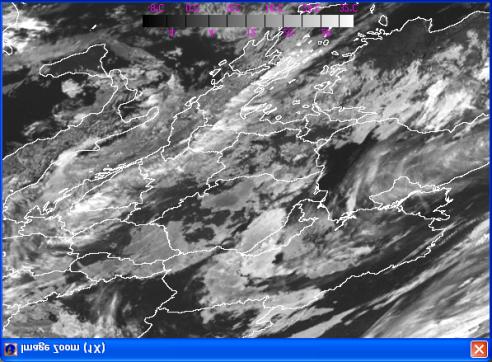
7 Zoom and See Details Airmass RGB

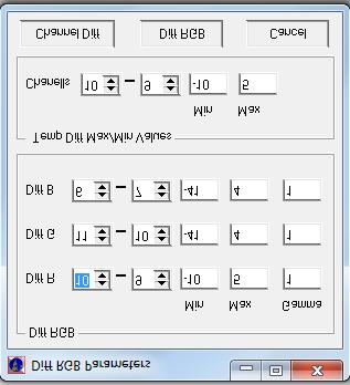
8 Make Tour Own RGB s or Difference Images


9 Create Daily Vegetation Index (NDVI) Daily MSG NDVI for full disk or selected area are possible to prdocue. Product is saved as HDF5 file format.

10 Scatter Plot Diagrams To Analyze RGB Images Scatter plot diagrams are avaliable for the RGB composite image.


11 Save Image as Physical Values (BT or Reflectance)


12 Select Cycles and Make Animation Dust RGB MSGView Software is free, if you would like to get a copy please send an to agerturk@dmi.gov.tr or look at the announcement at or web sites.


13 Cold U/V & Ring Shape Storm Tops Features by Using MSG Imagery
14 SEVIRI Channels & Applications SEVIRI Channels VIS0.6 VIS0.8 NIR1.6 IR3.9 WV6.2 WV7.3 IR8.7 IR9.7 IR10.8 IR12.0 Applications Optical tickness Optical thickness, vegetation Ice&snow detection, particle size & phase Ice&snow, particle size & phase, fire, fog, sun glint, SST Upper level moisture Mid level moisture Top temperature, dust Ozone Top temperature, cloud analysis, convection, CTH Top temperature, LST, SST IR13.4 CO 2 HRV Cloud detail (1 km)

15 SEVIRI Channels & RGB Composites for Convection Window Channels (IR10.8, IR12.0 & IR 8.7) - CTT, CTH NIR1.6 & IR3.9 Particle size and cloud phase WV Channels - moisture Storms, Airmasses, Date and Night Microphysics RGB HRV Cloud detail, anvils

16 Detection of Cold U/V Storms using IR Window Channel Grayscale It is difficult to see storms top structure with gray scaled IR image but enhanced ones with appropriate look-up table gives more details. IR LUT 5 Nov 2007, GMT METEOSAT 9 IR10.8 Image. Thunderstorm over Southwestern coast of Turkey
17 Detection of Cold U/V Storms using IR Window Channel Cold U/V shape (or enhanced-v) storms can be detected with IR image, Hemisfield & Blackmer (1988) were introduced a model by using satellite imagery. Cold Area (CA), Close-in Warm Area (CWA) and Distant Warm Area (DWA) are noticeable. The Model of V Shape Storms (Heymsfield & Blackmer 1988). 5 Nov 2007, GMT METEOSAT 9 IR10.8 Image. CA -72, CWA -55, DWA -58 C.

18 Detection of Cold U/V Storms IR Channel Enhanced CLOSE-IN WARM AREA -CWA DISTANT WARM AREA - DWA COLD-U/V COLD AREA- CA 5 Kasım 2007, GMT METEOSAT 9 enhanced IR10.8 image.

19 Detection of Cold U/V Storms Brightness Temperature Difference (BTD) of WV6.2 and IR 10.8 channel is also crucial indicator for convective storms. Positive difference is indicated existence of convection. Grayscale 5 Nov 2007, GMT METEOSAT 9 IR10.8 Image. Thunderstorm over Southwestern coast of Turkey IR LUT 5 Nov 2007, GMT METEOSAT 9 BTD of WV6.2 - IR10.8 Image.
20 HRV Convection Ref: Wang,2007 1) 2) 3) Cloud top Cirrus Plume Gravity waves IR LUT 5 Nov 2007, GMT METEOSAT 9 HRV Image. Thunderstorm over Southwestern coast of Turkey

21 HRV Convection Grayscale IR LUT 5 Nov 2007, HRV Loop. Thunderstorm over Southwestern coast of Turkey
 storms RGB image does not have enough details. 5 Nov 2007, 06.00 GMT METEOSAT 9 Storm RGB Image.")
22 Detection of Cold U/V Storms using Storms RGB Storms RGB is also crucial application to detect convective storms and Cb tops (yellow) is noticeable. In this case, due to low sun shine (early morning) storms RGB image does not have enough details. 5 Nov 2007, GMT METEOSAT 9 Storm RGB Image. Thunderstorm over Southwestern coast of Turkey

23 Detection of Cold U/V Storms Airmasses RGB 06:00 06:30 07:00 07:30 07:45 08:00 Grayscale 5 Nov 2007, 06:00-08:00 GMT Airmasses RGB Images. Thunderstorm IR LUT over Southwestern coast of Turkey 23

24 Detection of Cold Ring Storms using IR Window Channel Ref: Setvak at. al.,2007 CENTRAL WARM SPOT - CWS Grayscale COLD RING IR LUT 26 October 2009, GMT METEOSAT 9 IR10.8 image. Cold ring shape storm over Cyprus.

25 Detection of Cold Ring Storms using IR Window Channel Grayscale IR LUT 26 October 2009, GMT METEOSAT 9 IR10.8 image. Cold ring shape storm over Cyprus.

26 Detection of Cold U/V Storms Using HRV Image Cb top and gravity waves are easly noticed from HRVIS image. 26 October 2009, GMT METEOSAT 9 HRVIS image. Cold ring shape storm over Cyprus.

 BTD WV6.2-IR10.")
27 Cold Ring Storms BTD of WV6.2 - IR10.8 Channels 11:30 11:45 11:30 11:45 26 October 2009, 11: , Storms RGB composite (up) BTD WV6.2-IR10.8 Channels (down). Cold ring shape storm over Cyprus. IR LUT


28 Convection - IR Window Channel Applications Squall Line Enhanced IR Grayscale IR LUT 26 March 2007, GMT METEOSAT 9 IR10.8 Image with a special color table. Squall line over Saudi Arabia
 and Airmases RGB (right) composite Image.")
29 Convection Storms RGB & Airmasses RGB Composite Grayscale IR LUT 26 March 2007, GMT Storms RGB (left) and Airmases RGB (right) composite Image.Squall line over Saudi Arabia


 and Storms")
30 Convection IR 108, Diff WV and Storms RGB Composite Grayscale 26 March 2007, GMT IR10.8 (left), BTD of WV channels (mid) and Storms RGB composite(right).


31 Convection Scatter Plot Diagrams For deep convection (yellow) Grayscale reflectance differences of VIS06 and NIR16 is around %35-45, BT of IR108 is around K, BTD of WV channels is around -3 and 1 K and BTD of WV62 and IR108 is around -2 and 2 K. IR LUT Convection is well recognized with the scatter plot diagrams. The colours are same as Storms RGB composite image 26 March 2007, GMT Storms RGB composite and scatter plot diagrams.


32 Case Study : 2 April 2011 Hail Storm over Antalya, Türkiye
 were covered over land around 10 cm.")
33 Hail Storm, 02 April 2011 over Antalya A severe storm effected over Aksu town near Antalya city at 2nd April 2011, around 13:00 GMT, a lady was dead, many green-houses were destroyed and economic loses are around hundreds of millions USD. Hailstones (over 2 cm diameter) were covered over land around 10 cm. 2 April 2011, 13:00 UTC Airmasses RGB image.


.")
34 Cold Ring Shape Storm 02 April 2011, Antalya 12:45 13:00 13:15 12:45 13:00 13:15 2 April 2011, 12:45 13:15 enh. IR 10.8 image (up) and HRV image (down). Cold ring shape storm over Antalya.
 and HRV loop (right).")

35 Cold Ring Shape Storm 02 April 2011, Antalya 35 HRV IR LUT Enhanced IR 10.8 loop (up) and HRV loop (right). Storm cell seems very small but it caused severe weather. This case shows that cold ring shape storms can be casued severe weather even if it is small size.
36 Conclusion MSG SEVIRI images (with its 12 channels and 15 minutes temporal resolution) are cruical data sources for nowcasting and very short term forecasting. MSGView software has many features for utilising, display and animate MSG images and RGB composites. Usage of this software is free. Enhanced IR images, BTD s images and RGB composite images give a possibility to detect convective storms especially Cold U/V and Cold Ring shape storms cloud tops. Case study dated 2 April 2011 shows that it is possible to detect cold ring shape storms before minutes by using MSG SEVIRI images and applications. References: Ertürk A. G., 2010 "MSGView: An operational and training tool to process, analyze and visualization of MSG SEVIRI data", /Proceedings of 10th EUMETSAT Conference/, EUMETSAT P.57, Darmstadt, Germany, Heymsfield, G. M. and Blackmer R. H., 1988: Satellite-observed characteristics of Midwest severe thunderstorm anvils. Monthly Weather Review, 116, Setvák, M., Lindsey, D. T., Novák, P., Wang, P. K., Radová, M., Kerkmann, J., Grasso, L., Su, S., Rabin, R. M., Šťástka, J., Charvát, Z., 2010 Satellite-observed cold-ring-shaped features atop deep convective clouds. Atmos. Res. 97, Wang, P.K., The thermodynamic structure atop a penetrating convective thunderstorm. Atmos. Res. 83,
37 37 Thank you!
MSGVIEW: AN OPERATIONAL AND TRAINING TOOL TO PROCESS, ANALYZE AND VISUALIZATION OF MSG SEVIRI DATA
 MSGVIEW: AN OPERATIONAL AND TRAINING TOOL TO PROCESS, ANALYZE AND VISUALIZATION OF MSG SEVIRI DATA Aydın Gürol Ertürk Turkish State Meteorological Service, Remote Sensing Division, CC 401, Kalaba Ankara,
Applications of multi-spectral satellite data
 Applications of multi-spectral satellite data Jochen Kerkmann EUMETSAT, Satellite Meteorologist, Training Officer Adjusted by E de Coning South African Weather Service Content 1. Why should we use RGBs?
COLD-RING AND COLD-U/V SHAPED STORMS
 MARTIN SETVÁK setvak@chmi.cz Czech Hydrometeorological Institute, Prague COLD-RING AND COLD-U/V SHAPED STORMS Version : 18 May 2009 What are the cold-ring and cold-u/v shaped storms? Appearance and terminology
SATELLITE MONITORING OF THE CONVECTIVE STORMS
 SATELLITE MONITORING OF THE CONVECTIVE STORMS FORECASTERS POINT OF VIEW Michaela Valachová, EUMETSAT Workshop at ECMWF User Meeting Reading, 13 June 2017 Central Forecasting Office, Prague michaela.valachova@chmi.cz
CHARACTERISTICS OF EMBEDDED WARM AREAS AND SURROUNDING COLD RINGS AND COLD-US
 CHARACTERISTICS OF EMBEDDED WARM AREAS AND SURROUNDING COLD RINGS AND COLD-US Michaela Radová 1,2, Jindřich Šťástka 1,2, Jakub Seidl 3 (1) Department of Meteorology and Environment Protection, Faculty
How to display RGB imagery by SATAID
 How to display RGB imagery by SATAID Akihiro SHIMIZU Meteorological Satellite Center (MSC), Japan Meteorological Agency (JMA) Ver. 2015110500 RGB imagery on SATAID SATAID software has a function of overlapping
Nowcasting of Severe Weather from Satellite Images (for Southern
 Nowcasting of Severe Weather from Satellite Images (for Southern Europe) Petra Mikuš Jurković Forecasting/ nowcasting of convective storms NWP models cannot well predict the exact location and intesity
Czech Hydrometeorological Institute, Na Šabatce 17, CZ Praha 4, Czech Republic. 3
 MOISTURE DETECTION ABOVE CONVECTIVE STORMS UTILIZING THE METHOD OF BRIGHTNESS TEMPERATURE DIFFERENCES BETWEEN WATER VAPOR AND IR WINDOW BANDS, BASED ON 2008 MSG RAPID SCAN SERVICE DATA Jindřich Šťástka1,2,
RGB Products: an easy and practical way to display multispectral satellite data (in combination with derived products)
") RGB Products: an easy and practical way to display multispectral satellite data (in combination with derived products) Dr. Jochen Kerkmann Training Officer EUMETSAT Multi-channel GEO satellites today Him-08
RGB Products: an easy and practical way to display multispectral satellite data (in combination with derived products) Dr. Jochen Kerkmann Training Officer EUMETSAT Multi-channel GEO satellites today Him-08
Cold-ring shaped storms
 MARTIN SETVÁK setvak@chmi.cz CZECH HYDROMETEOROLOGICAL INSTITUTE Cold-ring shaped storms 25 June 2006 (Czech Republic and Austria) EUMeTrain Convection Training Week 2008 02 June 2008 Our storms cloud-tops
OVERSHOOTING TOPS CHARACTERISTICS AND PROPERTIES
 OVERSHOOTING TOPS CHARACTERISTICS AND PROPERTIES Michaela Valachová 1,2, Martin Setvák 2, Jindřich Šťástka 1,2 1 Charles University in Prague, Faculty of Mathematics and Physics, Department of Meteorology
MSG Indian Ocean Data Coverage (IODC) Jochen Grandell & Sauli Joro
 Jochen Grandell & Sauli Joro") MSG Indian Ocean Data Coverage (IODC) Jochen Grandell & Sauli Joro 1 EUM/STG-SWG/42/17/VWG/03 v1, 7 8 Mach 2017 Topics Introduction MSG-IODC Overall Project Schedule Status Product validation Products
MSG Indian Ocean Data Coverage (IODC) Jochen Grandell & Sauli Joro 1 EUM/STG-SWG/42/17/VWG/03 v1, 7 8 Mach 2017 Topics Introduction MSG-IODC Overall Project Schedule Status Product validation Products
RGB Experts and Developers Workshop - Introduction Tokyo, Japan 7-9 Nov 2017
 RGB Experts and Developers Workshop - Introduction Tokyo, Japan 7-9 Nov 2017 Workshop Objectives Review of existing RGB standards Reconfirm and extend existing standards (new multi-spectral imagers) Stimulate
CASE STUDY OF THE 20 MAY 2008 TORNADIC STORM IN HUNGARY
 CASE STUDY OF THE 20 MAY 2008 TORNADIC STORM IN HUNGARY Mária Putsay 1, Jochen Kerkmann 2 and Ildikó Szenyán 1 1 Hungarian Meteorological Service, H-1525 Budapest, P. O. Box 38, Hungary 2 EUMETSAT, am
MSG FOR NOWCASTING - EXPERIENCES OVER SOUTHERN AFRICA
 MSG FOR NOWCASTING - EXPERIENCES OVER SOUTHERN AFRICA Estelle de Coning and Marianne König South African Weather Service, Private Bag X097, Pretoria 0001, South Africa EUMETSAT, Am Kavalleriesand 31, D-64295
" The usefulness of RGB products: the perspective of the Australian Bureau of Meteorology "
 " The usefulness of RGB products: the perspective of the Australian Bureau of Meteorology " Presenter: Bodo Zeschke. Bureau of Meteorology Training Centre, Australian VLab Centre of Excellence Point of
REPORT ON THE ACTIVITIES OF THE EUMETSAT-ESSL CONVECTION WORKING GROUP
 REPORT ON THE ACTIVITIES OF THE EUMETSAT-ESSL CONVECTION WORKING GROUP Marianne König EUMETSAT, Eumetsat Allee 1, 64295 Darmstadt, Germany Abstract The focus of the Convection Working Group is to have
RGB Experts and Developers Workshop 2017 Tokyo, Japan
 "Application of the Sandwich Product and variations to this as used by Australian Forecasters and as presented during training at the Australian VLab Centre of Excellence". RGB Experts and Developers Workshop
Satellite Meteorology. Protecting Life and Property Around the World
 Satellite Meteorology Protecting Life and Property Around the World The Value of Forecasting Severe Weather Flooding events across Europe in August 2002 cost in the region of 20 billion; 20,000 people
INTERPRETATION OF MSG IMAGES, PRODUCTS AND SAFNWC OUTPUTS FOR DUTY FORECASTERS
 INTERPRETATION OF MSG IMAGES, PRODUCTS AND SAFNWC OUTPUTS FOR DUTY FORECASTERS M. Putsay, M. Rajnai, M. Diószeghy, J. Kerényi, I.G. Szenyán and S. Kertész Hungarian Meteorological Service, H-1525 Budapest,
Day Microphysics RGB Nephanalysis in daytime. Meteorological Satellite Center, JMA
 Day Microphysics RGB Nephanalysis in daytime Meteorological Satellite Center, JMA What s Day Microphysics RGB? R : B04 (N1 0.86) Range : 0~100 [%] Gamma : 1.0 G : B07(I4 3.9) (Solar component) Range :
Applications of the SEVIRI window channels in the infrared.
 Applications of the SEVIRI window channels in the infrared jose.prieto@eumetsat.int SEVIRI CHANNELS Properties Channel Cloud Gases Application HRV 0.7 Absorption Scattering
New possibilities for access and utilisation of EUMETSAT data and products through DAWBEE programme
 See discussions, stats, and author profiles for this publication at: https://www.researchgate.net/publication/273637605 New possibilities for access and utilisation of EUMETSAT data and products through
PRECONVECTIVE SOUNDING ANALYSIS USING IASI AND MSG- SEVIRI
 PRECONVECTIVE SOUNDING ANALYSIS USING IASI AND MSG- SEVIRI Marianne König, Dieter Klaes EUMETSAT, Eumetsat-Allee 1, 64295 Darmstadt, Germany Abstract EUMETSAT operationally generates the Global Instability
MSG system over view
 MSG system over view 1 Introduction METEOSAT SECOND GENERATION Overview 2 MSG Missions and Services 3 The SEVIRI Instrument 4 The MSG Ground Segment 5 SAF Network 6 Conclusions METEOSAT SECOND GENERATION
Global Instability Index: Product Guide
 Doc.No. Issue : : EUM/TSS/MAN/15/802106 v1c e-signed EUMETSAT Eumetsat-Allee 1, D-64295 Darmstadt, Germany Tel: +49 6151 807-7 Fax: +49 6151 807 555 Date : 2 September 2015 http://www.eumetsat.int WBS/DBS
Remote Sensing Seminar 8 June 2007 Benevento, Italy. Lab 5 SEVIRI and MODIS Clouds and Fires
 Remote Sensing Seminar 8 June 2007 Benevento, Italy Lab 5 SEVIRI and MODIS Clouds and Fires Table: SEVIRI Channel Number, Wavelength (µm), and Primary Application Reflective Bands 1,2 0.635, 0.81 land/cld
Preparation for Himawari 8
 Preparation for Himawari 8 Japan Meteorological Agency Meteorological Satellite Center Hidehiko MURATA ET SUP 8, WMO HQ, Geneva, 14 17 April 2014 1/18 Introduction Background The Japan Meteorological Agency
The water vapour channels of SEVIRI (Meteosat). An introduction
. An introduction") The water vapour channels of SEVIRI (Meteosat). An introduction jose.prieto@eumetsat.int Cachoeira P. July 2006 Formats 1.5 1 Objectives 2 Describe the characteristics of WV channels on board of SEVIRI
The water vapour channels of SEVIRI (Meteosat). An introduction jose.prieto@eumetsat.int Cachoeira P. July 2006 Formats 1.5 1 Objectives 2 Describe the characteristics of WV channels on board of SEVIRI
Ash RGB Detection of Volcanic Ash
 Copyright, JMA RGB Detection of Volcanic Meteorological Satellite Center, JMA Ver. 20150424 Volcanic Detection by Infrared and Difference Image, and Basis Himawari-8 B15-B13 2015-02-16 06:35 UTC Himawari-8
HARMONISING SEVIRI RGB COMPOSITES FOR OPERATIONAL FORECASTING
 HARMONISING SEVIRI RGB COMPOSITES FOR OPERATIONAL FORECASTING HansPeter Roesli (1), Jochen Kerkmann (1), Daniel Rosenfeld (2) (1) EUMETSAT, Darmstadt DE, (2) The Hebrew University of Jerusalem, Jerusalem
MSG/SEVIRI CHANNEL 4 Short-Wave IR 3.9 m IR3.9 Tutorial
 MSG/SEVIRI CHANNEL 4 Short-Wave IR Channel @ 3.9 m IR3.9 Tutorial HansPeter Roesli EUMETSAT satmet.hp@ticino.com Contributions: D Rosenfeld (HUJ) J Kerkmann (EUM), M Koenig (EUM), J Prieto (EUM), HJ Lutz
SAFNWC/MSG Dust flag.
 SAFNWC/MSG Dust flag. Dust Week 1-5 March 2010 Hervé LE GLEAU, Marcel DERRIEN Centre de météorologie Spatiale. Lannion Météo-France 1 Plan SAFNWC context Dust flag in SAFNWC/MSG Cma product Algorithm description
YELLOW SPOT IN THE CONVECTIVE STORMS RGB IMAGE CAUSED BY A PILEUS CLOUD
 YELLOW SPOT IN THE CONVECTIVE STORMS RGB IMAGE CAUSED BY A PILEUS CLOUD André Simon, Mária Putsay, Ildikó Szenyán and Ákos Horváth Hungarian Meteorological Service, Kitaibel Pál u. 1, H-1024 Budapest,
Monitoring Sand and Dust Storms from Space
 Monitoring Sand and Dust Storms from Space for Expert Consultation on Disaster Information and Knowledge, Session 2 ICC 21 for ESCAP s RESAP and CDRR 5 9 12 October, 2017 Toshiyuki KURINO WMO Space Programme
Cloud analysis from METEOSAT data using image segmentation for climate model verification
 Cloud analysis from METEOSAT data using image segmentation for climate model verification R. Huckle 1, F. Olesen 2 Institut für Meteorologie und Klimaforschung, 1 University of Karlsruhe, 2 Forschungszentrum
METEOSAT THIRD GENERATION
 METEOSAT THIRD GENERATION FACTS AND FIGURES MONITORING WEATHER AND CLIMATE FROM SPACE A HIGHLY INNOVATIVE GEOSTATIONARY SATELLITE SYSTEM FOR EUROPE AND AFRICA The Meteosat Third Generation (MTG) system
Himawari-8 True Color RGB
 Himawari-8 True Color RGB Meteorological Satellite Center, JMA Ver. 20150519 What s True Color RGB? R : B03(VS 0.64) G : B02(V2 0.51) 2015-03-17 00UTC B : B01(V1 0.46) Components of True Color RGB Channel
Recommendation proposed: CGMS-39 WGII to take note.
 Prepared by EUMETSAT Agenda Item: G.II/8 Discussed in WGII EUM REPORT ON CAPABILITIES AND PLANS TO SUPPORT VOLCANIC ASH MONITORING In response to CGMS action WGII 38.31: CGMS satellite operators are invited
METEOSAT CONVECTIVE INITIATION PRODUCT WITH AND WITHOUT CLOUD TRACKING - EXPERIENCES
 METEOSAT CONVECTIVE INITIATION PRODUCT WITH AND WITHOUT CLOUD TRACKING - EXPERIENCES Mária Putsay 1, Zsófia Kocsis 1, Marianne König 2, Ildikó Szenyán 1, Márta Diószeghy 1, André Simon 1 and Márk Rajnai
Khalid Y. Muwembe UGANDA NATIONAL METEOROLOGICAL AUTHORITY (UNMA)
") Forecasting Severe Weather over Lake Victoria region in Uganda Khalid Y. Muwembe UGANDA NATIONAL METEOROLOGICAL AUTHORITY (UNMA) Outline Background Set-up of forecasting/alert service Diurnal circulation
Forecasting Severe Weather over Lake Victoria region in Uganda Khalid Y. Muwembe UGANDA NATIONAL METEOROLOGICAL AUTHORITY (UNMA) Outline Background Set-up of forecasting/alert service Diurnal circulation
T-re Plots Generated from MSG Data in Severe Storms Forecasting Testing in Central Europe
 WDS'11 Proceedings of Contributed Papers, Part III, 88 92, 2011. ISBN 978-80-7378-186-6 MATFYZPRESS T-re Plots Generated from MSG Data in Severe Storms Forecasting Testing in Central Europe M. Pokorný
LANDSAF SNOW COVER MAPPING USING MSG/SEVIRI DATA
 LANDSAF SNOW COVER MAPPING USING MSG/SEVIRI DATA Niilo Siljamo and Otto Hyvärinen Finnish Meteorological Institute, Erik Palménin aukio 1, P.O.Box 503, FI-00101 Helsinki, Finland Abstract Land Surface
CHARACTERISTICS OF LIGHTNING ACTIVITY IN DEEP CONVECTIVE CLOUDS WITH THE OVERSHOOTING TOPS
 CHARACTERISTICS OF LIGHTNING ACTIVITY IN DEEP CONVECTIVE CLOUDS WITH THE OVERSHOOTING TOPS Petra Mikuš, Nataša Strelec Mahović Meteorological and Hydrological Service, Grič 3, Zagreb, Croatia Abstract
Hail nowcast exploiting radar and satellite observations
 Federal Department of Home Affairs FDHA Federal Office of Meteorology and Climatology MeteoSwiss Hail nowcast exploiting radar and satellite observations Ulrich Hamann, Elena Leonarduzzi, Kristopher Bedka,
4.1 New Generation Satellite Data and Nowcasting Products: Himawari
 4.1 New Generation Satellite Data and Nowcasting Products: Himawari SCOPE-Nowcasting-EP 18-20 September 2017 Koji Yamashita kobo.yamashita@met.kishou.go.jp Meteorological Satellite Center (MSC) Japan Meteorological
Simulated MSG SEVIRI Imagery from HARMONIE-AROME
 Simulated MSG SEVIRI Imagery from HARMONIE-AROME Angeles Hernandez, AEMET Joint 28th ALADIN Workshop & HIRLAM All-Staff Meeting 2018 - Toulouse, 16-20 Apr 2018 Outline 1. Simulated Satellite Images (SSI)
Overview of Himawari-8/9
 Overview of Himawari-8/9 Toshiyuki SAKURAI Meteorological Satellite Center (MSC) Japan Meteorological Agency (JMA) EUMeTrain Event Week on MTG-I Satellite 2016 Session2 - Himawari-8 and Data Applications
Product User Manual for Cloud. Products (CMa-PGE01 v3.2, CT-
 Page: 1/34 Product User Manual for Cloud SAF/NWC/CDOP2/MFL/SCI/PUM/01, Issue 3, Rev. 2.3 4 December 2014 Applicable to SAFNWC/MSG version 2013 Prepared by Météo-France / Centre de Météorologie Spatiale
Introduction of JMA VLab Support Site on RGB Composite Imagery and tentative RGBs
 The Sixth Asia/Oceania Meteorological Satellite Users' Conference 9 13 November 2015, Tokyo/Japan J M A Introduction of JMA VLab Support Site on RGB Composite Imagery and tentative RGBs Akihiro SHIMIZU
Combined and parallel use of MSG composite images and SAFNWC/MSG products at the Hungarian Meteorological Service
 Combined and parallel use of MSG composite images and SAFNWC/MSG products at the Hungarian Meteorological Service Mária Putsay, Kornél Kolláth and Ildikó Szenyán Hungarian Meteorological Service H-1525
Comparison of cloud statistics from Meteosat with regional climate model data
 Comparison of cloud statistics from Meteosat with regional climate model data R. Huckle, F. Olesen, G. Schädler Institut für Meteorologie und Klimaforschung, Forschungszentrum Karlsruhe, Germany (roger.huckle@imk.fzk.de
Atmospheric Motion Vectors: Product Guide
 Atmospheric Motion Vectors: Product Guide Doc.No. Issue : : EUM/TSS/MAN/14/786435 v1a EUMETSAT Eumetsat-Allee 1, D-64295 Darmstadt, Germany Tel: +49 6151 807-7 Fax: +49 6151 807 555 Date : 9 April 2015
EUMETSAT PLANS. Dr. K. Dieter Klaes EUMETSAT Am Kavalleriesand 31 D Darmstadt Germany
 EUMETSAT PLANS Dr. K. Dieter Klaes EUMETSAT Am Kavalleriesand 31 D-64295 Darmstadt Germany Page 1 EUMETSAT SATELLITE PROGRAMMES 96 97 98 99 00 01 02 03 04 05 06 07 08 09 10 11 12 13 14 15 16 17 18 METEOSAT
Aviation Hazards: Thunderstorms and Deep Convection
 Aviation Hazards: Thunderstorms and Deep Convection TREND Diagnosis of thunderstorm hazards using imagery Contents Satellite imagery Visible, infrared, water vapour Basic cloud identification Identifying
Satellite data for African applications
 Satellite data for African applications Henk Verschuur, EUMETSAT henk.verschuur@eumetsat.int Introduction Some examples of satellite products which are useful for Africa Satellite products Tropical cyclones
Use of EUMETCast/GEONETCastat Regional Branch Offices in Ethiopia. KassaFekadu National Meteorological Agency of Ethiopia
 Use of EUMETCast/GEONETCastat Regional Branch Offices in Ethiopia KassaFekadu National Meteorological Agency of Ethiopia NMA 25 March 2015 Overview of Presentation Introduction and GEONETCast Toolbox EUMETCast
"Experiences with use of EUMETSAT MPEF GII product for convection/storm nowcasting"
 "Experiences with use of EUMETSAT MPEF GII product for convection/storm nowcasting" Marianne König 1, Monika Pajek 2, Piotr Struzik 2 1) EUMETSAT 2) Institute of Meteorology and Water Management, Kraków,
Satellite observation of atmospheric dust
 Satellite observation of atmospheric dust Taichu Y. Tanaka Meteorological Research Institute, Japan Meteorological Agency 11 April 2017, SDS WAS: Dust observation and modeling @WMO, Geneva Dust observations
VWG.01 EUMETSAT Corporate Slide Collection (EUM/CIS/VWG/14/743878) Version 1, January 2014 MONITORING WEATHER AND CLIMATE FROM SPACE
 Version 1, January 2014 MONITORING WEATHER AND CLIMATE FROM SPACE") 1 VWG.01 EUMETSAT Corporate Slide Collection (EUM/CIS/VWG/14/743878) Version 1, January 2014 MONITORING WEATHER AND CLIMATE FROM SPACE Royal charter: 25/26 October 1859 From observation to decision making:
1 VWG.01 EUMETSAT Corporate Slide Collection (EUM/CIS/VWG/14/743878) Version 1, January 2014 MONITORING WEATHER AND CLIMATE FROM SPACE Royal charter: 25/26 October 1859 From observation to decision making:
The importance of satellite data for nowcasting in the WWRP strategy
 The importance of satellite data for nowcasting in the WWRP strategy Estelle de Coning and Paolo Ruti World Weather Research Division Steve Goodman Chief Program Scientist, NOAA WMO definition Nowcasting
Joseph Kagenyi Principal Meteorologist (RS/GIS) IMTR-NAIROBI 13 th UFA September 2018
 IMTR-NAIROBI 13 th UFA September 2018") Joseph Kagenyi Principal Meteorologist (RS/GIS) IMTR-NAIROBI 13 th UFA 24-28 September 2018 kagenyijn@gmail.com 1. PUMA WorkStation structure 2. Data Available on PUMA Station 3. PUMA Nowcasting Applications
Joseph Kagenyi Principal Meteorologist (RS/GIS) IMTR-NAIROBI 13 th UFA 24-28 September 2018 kagenyijn@gmail.com 1. PUMA WorkStation structure 2. Data Available on PUMA Station 3. PUMA Nowcasting Applications
Operational Uses of Bands on the GOES-R Advanced Baseline Imager (ABI) Presented by: Kaba Bah
 Presented by: Kaba Bah") Operational Uses of Bands on the GOES-R Advanced Baseline Imager (ABI) Presented by: Kaba Bah Topics: Introduction to GOES-R & ABI ABI individual bands Use of band differences ABI derived products Conclusions
Operational Uses of Bands on the GOES-R Advanced Baseline Imager (ABI) Presented by: Kaba Bah Topics: Introduction to GOES-R & ABI ABI individual bands Use of band differences ABI derived products Conclusions
SAFNWC/MSG SEVIRI CLOUD PRODUCTS
 SAFNWC/MSG SEVIRI CLOUD PRODUCTS M. Derrien and H. Le Gléau Météo-France / DP / Centre de Météorologie Spatiale BP 147 22302 Lannion. France ABSTRACT Within the SAF in support to Nowcasting and Very Short
Use of satellite information in research and operational activities at NIMH of Bulgaria
 Use of satellite information in research and operational activities at NIMH of Bulgaria Rilka Valcheva NIMH, Bulgaria WMO/EUMETSAT Satellite Products Training Course 24-28 April 2017, Budapest, Hungary
Improving real time observation and nowcasting RDT. E de Coning, M Gijben, B Maseko and L van Hemert Nowcasting and Very Short Range Forecasting
 Improving real time observation and nowcasting RDT E de Coning, M Gijben, B Maseko and L van Hemert Nowcasting and Very Short Range Forecasting Introduction Satellite Application Facilities (SAFs) are
6A.4 REFLECTIVE STORM TOPS: A SATELLITE METHOD FOR INFERRING THUNDERSTORM TOP MICROPHYSICAL STRUCTURE. Fort Collins, Colorado. Fort Collins, Colorado
 6A.4 REFLECTIVE STORM TOPS: A SATELLITE METHOD FOR INFERRING THUNDERSTORM TOP MICROPHYSICAL STRUCTURE Daniel T. Lindsey 1* and Louie Grasso 2 1 NOAA/NESDIS/ORA/RAMMB Fort Collins, Colorado 2 Cooperative
USE OF SATELLITE INFORMATION IN THE HUNGARIAN NOWCASTING SYSTEM
 USE OF SATELLITE INFORMATION IN THE HUNGARIAN NOWCASTING SYSTEM Mária Putsay, Zsófia Kocsis and Ildikó Szenyán Hungarian Meteorological Service, Kitaibel Pál u. 1, H-1024, Budapest, Hungary Abstract The
Warning procedures for extreme events in the Emilia-Romagna Region
 Warning procedures for extreme events in the Emilia-Romagna Region Anna Fornasiero, Miria Celano, Roberta Amorati, Virginia Poli and Pier Paolo Alberoni Arpa Emilia-Romagna Hydro-Meteo-Climate Service,
Figure 1: Tephigram for radiosonde launched from Bath at 1100 UTC on 15 June 2005 (IOP 1). The CAPE and CIN are shaded dark and light gray,
. The CAPE and CIN are shaded dark and light gray,") Figure 1: Tephigram for radiosonde launched from Bath at 1100 UTC on 1 June 200 (IOP 1). The CAPE and CIN are shaded dark and light gray, respectively; the thin solid line partially bounding these areas
Figure 1: Tephigram for radiosonde launched from Bath at 1100 UTC on 1 June 200 (IOP 1). The CAPE and CIN are shaded dark and light gray, respectively; the thin solid line partially bounding these areas
Day Snow-Fog RGB Detection of low-level clouds and snow/ice covered area
 JMA Day Snow-Fog RGB Detection of low-level clouds and snow/ice covered area Meteorological Satellite Center, JMA What s Day Snow-Fog RGB? R : B04 (N1 0.86) Range : 0~100 [%] Gamma : 1.7 G : B05 (N2 1.6)
The use of Direct Broadcast Processing System in Poland
 The use of Direct Broadcast Processing System in Poland B.Łapeta, P.Struzik Satellite Remote Sensing Department, Institute of Meteortology and Water Management National Reasearch Institute About IMWM-NRI
Using McIDAS-V for Satellite-Based Thunderstorm Research and Product Development
 Using McIDAS-V for Satellite-Based Thunderstorm Research and Product Development Kristopher Bedka UW-Madison, SSEC/CIMSS In Collaboration With: Tom Rink, Jessica Staude, Tom Whittaker, Wayne Feltz, and
Cloud Top Height Product: Product Guide
 Cloud Top Height Product: Product Guide Doc.No. Issue : : EUM/TSS/MAN/14/786420 v1a EUMETSAT Eumetsat-Allee 1, D-64295 Darmstadt, Germany Tel: +49 6151 807-7 Fax: +49 6151 807 555 Date : 21 August 2015
Moisture, Clouds, and Precipitation: Clouds and Precipitation. Dr. Michael J Passow
 Moisture, Clouds, and Precipitation: Clouds and Precipitation Dr. Michael J Passow What Processes Lift Air? Clouds require three things: water vapor, a condensation nucleus, and cooling Cooling usually
Climatologies of ultra-low clouds over the southern West African monsoon region
 Climatologies of ultra-low clouds over the southern West African monsoon region Andreas H. Fink 1, R. Schuster 1, R. van der Linden 1, J. M. Schrage 2, C. K. Akpanya 2, and C. Yorke 3 1 Institute of Geophysics
Satellite-based Convection Nowcasting and Aviation Turbulence Applications
 Satellite-based Convection Nowcasting and Aviation Turbulence Applications Kristopher Bedka Cooperative Institute for Meteorological Satellite Studies (CIMSS), University of Wisconsin-Madison In collaboration
Convective Cloud Features in typical synoptic situations. Frans Debie
 Convective Cloud Features in typical synoptic situations Frans Debie me SATRAPPERS Henk vesa Frans Veronika ab Teachers classroom Langen Cumulonimbus: Convection Convection, seen from ground 1 2 3 4 Outflow
EUMETSAT products and services for monitoring storms - New missions, more data and more meteorological products
 EUMETSAT products and services for monitoring storms - New missions, more data and more meteorological products Jochen Grandell 1 EUM/RSP/VWG/17/921460 Outline Overview of EUMETSAT missions Current...and
EUMETSAT SAF NETWORK. Lothar Schüller, EUMETSAT SAF Network Manager
 1 EUMETSAT SAF NETWORK Lothar Schüller, EUMETSAT SAF Network Manager EUMETSAT ground segment overview METEOSAT JASON-2 INITIAL JOINT POLAR SYSTEM METOP NOAA SATELLITES CONTROL AND DATA ACQUISITION FLIGHT
EUMETSAT/15 TH AMS SATELLITE CONFERENCE
 EUMETSAT/15 TH AMS SATELLITE CONFERENCE Toward An Objective Enhanced-V Detection Algorithm University of Wisconsin-Madison/CIMSS Jason Brunner, Wayne Feltz, John Moses, Robert Rabin, and Steven Ackerman
Optical properties of thin cirrus derived from the infrared channels of SEVIRI
 Optical properties of thin cirrus derived from the infrared channels of SEVIRI Stephan Kox, A. Ostler, M. Vazquez-Navarro, L. Bugliaro, H. Mannstein Deutsches Zentrum für Luft- und Raumfahrt (DLR), Oberpfaffenhofen,
EUMETSAT LSA-SAF EVAPOTRANSPIRATION PRODUCTS STATUS AND PERSPECTIVES
 EUMETSAT LSA-SAF EVAPOTRANSPIRATION PRODUCTS STATUS AND PERSPECTIVES Arboleda, N. Ghilain, F. Gellens-Meulenberghs Royal Meteorological Institute, Avenue Circulaire, 3, B-1180 Bruxelles, BELGIUM Corresponding
OPERATIONAL USE OF METEOSAT-8 SEVIRI DATA AND DERIVED NOWCASTING PRODUCTS. Nataša Strelec Mahović
 OPERATIONAL USE OF METEOSAT-8 SEVIRI DATA AND DERIVED NOWCASTING PRODUCTS Nataša Strelec Mahović Meteorological and Hydrological Service Grič 3, 10 000 Zagreb, Croatia strelec@cirus.dhz.hr ABSTRACT Meteosat-8
AOMSUC-6 Training Event
 Effective use of high temporal and spatial resolution Himawari-8 data AOMSUC-6 Training Event Bodo Zeschke Australian Bureau of Meteorology Training Centre Australian VLab Centre of Excellence Content
Country scale solar irradiance forecasting for PV power trading
 Country scale solar irradiance forecasting for PV power trading The benefits of the nighttime satellite-based forecast Sylvain Cros, Laurent Huet, Etienne Buessler, Mathieu Turpin European power exchange
NWC-SAF Satellite Application Facility in Support to Nowcasting and Very Short Range Forecasting
 NWC-SAF Satellite Application Facility in Support to Nowcasting and Very Short Range Forecasting Marianne König Slide 1 Satellite Application Facilities (SAFs) in Europe Member State Cooperating State
EUMETSAT Satellite Programmes Use of McIDAS at EUMETSAT
 EUMETSAT Satellite Programmes Use of McIDAS at EUMETSAT Marianne König Peter Miu McIDAS Users' Group Meeting, 07-10 May 2012 Slide 1 EUMETSAT Headquarters Darmstadt McIDAS Users' Group Meeting, 07-10 May
Satellite-based thunderstorm tracking, monitoring and nowcasting over South Africa
 Satellite-based thunderstorm tracking, monitoring and nowcasting over South Africa Caroline Forster 1, Estelle de Coning 2, Sebastian Diebel 1, Tobias Zinner 3 EUMETSAT Meteorological Satellite Conference
REPRESENTING EUMETSAT S ACTIVE FIRE MONITORING PRODUCT BY GOOGLE EARTH OVER TURKEY
 REPRESENTING EUMETSAT S ACTIVE FIRE MONITORING PRODUCT BY GOOGLE EARTH OVER TURKEY Ahmet Emre TEKELİ 1, İbrahim SÖNMEZ 1, Erdem ERDİ 1, Fatih DEMİR 1, Murat ARSLAN 1, Meral L. ÇUKURÇAYIR 1, Hakan KOÇAK
Meteorological product extraction: Making use of MSG imagery
 Meteorological product extraction: Making use of MSG imagery Kenneth Holmlund, Simon Elliott, Leo van de Berg, Stephen Tjemkes* Meteorological Operations Division *Meteorological Division EUMETSAT Am Kavalleriesand
EUMETSAT s Support to Climate Services and User Support. Joachim Saalmüller
 EUMETSAT s Support to Climate Services and User Support Joachim Saalmüller 1 User Forum in Africa September 2016 Outline of my talk EUMETSAT in support of climate services Exploring our data and subscribing
Usage of McIDAS V with GOES R AWG products
 McIDAS User Group Meeting, October 25-27, 2010, Madison, WI Usage of McIDAS V with GOES R AWG products William Straka III UW/CIMSS Madison, Wisconsin, USA With help from Tom Rink (CIMSS/), Tom Achtor (CIMSS/),
Application of Himawari-8 AHI Data to the GOES-R Rainfall Rate Algorithm
 Application of Himawari-8 AHI Data to the GOES-R Rainfall Rate Algorithm Yaping Li 1, Robert Kuligowski 2 and Yan Hao 1 1. IMSG at NOAA/NESDIS/STAR 2. NOAA/NESDIS/STAR, College Park, MD 1 GOES-R Baseline
ECNU WORKSHOP LAB ONE 2011/05/25)
") ECNU WORKSHOP LAB ONE (Liam.Gumley@ssec.wisc.edu 2011/05/25) The objective of this laboratory exercise is to become familiar with the characteristics of MODIS Level 1B 1000 meter resolution data. After
ECNU WORKSHOP LAB ONE (Liam.Gumley@ssec.wisc.edu 2011/05/25) The objective of this laboratory exercise is to become familiar with the characteristics of MODIS Level 1B 1000 meter resolution data. After
NEFODINA: A TOOL FOR AUTOMATIC DETECTION OF SEVERE CONVECTIVE PHENOMENA
 NEFODINA: A TOOL FOR AUTOMATIC DETECTION OF SEVERE CONVECTIVE PHENOMENA Davide MELFI IAFMS, Centro Operativo per la Meteorologia, Pomezia (Rome), Italy Abstract The NEFODINA (DYNAmic NEFOanalisys) product
THE ATMOSPHERIC MOTION VECTOR RETRIEVAL SCHEME FOR METEOSAT SECOND GENERATION. Kenneth Holmlund. EUMETSAT Am Kavalleriesand Darmstadt Germany
 THE ATMOSPHERIC MOTION VECTOR RETRIEVAL SCHEME FOR METEOSAT SECOND GENERATION Kenneth Holmlund EUMETSAT Am Kavalleriesand 31 64293 Darmstadt Germany ABSTRACT The advent of the Meteosat Second Generation
SNOW COVER MAPPING USING METOP/AVHRR DATA
 SNOW COVER MAPPING USING METOP/AVHRR DATA Niilo Siljamo, Markku Suomalainen, Otto Hyvärinen Finnish Meteorological Institute, Erik Palménin Aukio 1, FI-00101 Helsinki, Finland Abstract LSA SAF snow cover
The NASA Short-term Prediction Research and Transition (SPoRT) Center:
 Center:") The NASA Short-term Prediction Research and Transition (SPoRT) Center: Opportunities for Collaboration in the Great Lakes Region Andrew Molthan NASA Marshall Space Flight Center, Huntsville, AL andrew.molthan@nasa.gov
The NASA Short-term Prediction Research and Transition (SPoRT) Center: Opportunities for Collaboration in the Great Lakes Region Andrew Molthan NASA Marshall Space Flight Center, Huntsville, AL andrew.molthan@nasa.gov
CHARACTERISATION OF STORM SEVERITY BY USE OF SELECTED CONVECTIVE CELL PARAMETERS DERIVED FROM SATELLITE DATA
 CHARACTERISATION OF STORM SEVERITY BY USE OF SELECTED CONVECTIVE CELL PARAMETERS DERIVED FROM SATELLITE DATA Piotr Struzik Institute of Meteorology and Water Management, Satellite Remote Sensing Centre