" The usefulness of RGB products: the perspective of the Australian Bureau of Meteorology "
|
|
|
- Emmeline York
- 5 years ago
- Views:
Transcription


1 " The usefulness of RGB products: the perspective of the Australian Bureau of Meteorology " Presenter: Bodo Zeschke. Bureau of Meteorology Training Centre, Australian VLab Centre of Excellence Point of Contact Should you use these resources please acknowledge the Australian Bureau of Meteorology Training Centre. In addition, you need to retain acknowledgement in the PowerPoint slides of the Japan Meteorological Agency, the Australian Bureau of Meteorology and any other sources of information.
2 Contents of this session 1 2 The new capabilities of Himawari-8 / 9 True Colour RGB: Volcanic Ash 3 4 Night Microphysics RGB: Fog/Low Cloud Day Convection RGB: Thunderstorms, Tropical Storms


3 Changes from MTSAT-2 to Himawari-8 Himawari-8 MTSAT-2 10 minute images in colour Hourly / half hourly images in greyscale satellite images courtesy Japan Meteorological Agency (JMA)
4 Question to 115 Australian Bureau of Meteorology staff*: Compare the usefulness of Himawari-8 data to MTSAT-2 data when forecasting More useful Same Not used MTSAT-2 data Other comments * Results to be published in the research paper "How Himawari-8 data has revolutionised the work of Bureau Forecasters", Zeschke et al. 2018

5 Forecaster use of Himawari-8 data Day / night product transition Various speeds of animation Multi-panel displays Adapting the EUMETSAT tuned products to Himawari-8 data by regional forecasters and other operational staff

6 Adapting the EUMETSAT tuned products to Himawari-8 data by regional forecasters and other operational staff There are a lot of resources pertaining to WMO RAV stakeholders development of Himawari-8 data and data products posted on this web page. This includes the recordings of over four years of monthly Australian VLab Centre of Excellence Regional Focus Group meetings.

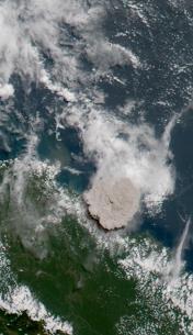
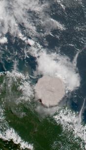
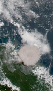
7 True Colour RGB: Detection and monitoring of volcanic ash Tavurvur eruption, Papua New Guinea, June 2009 image from Wikimedia Commons (author Taro Taylor)
 Himawari-8 True Colour RGB 10 minute")
8 10 minute Himawari-8 data permits the eruption to be captured in near real time The Himawari-8 product shows the brown volcanic ash and the white cloud images courtesy JMA/BOM MTSAT-2 greyscale visible channel compared to Himawari-8 True Colour RGB Manam volcanic eruption of 31 st July to 0225UTC MTSAT-2 hourly data (start of scan time given) Himawari-8 True Colour RGB 10 minute data (start of scan time given)


 Photo courtesy of David Innes, Air")
 Ash below cloud to FL330 (Manam")
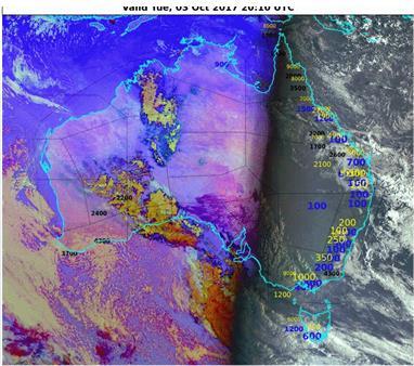
9 Some limitations in monitoring volcanic ash eruptions by satellite images courtesy JMA/BOM Himawari-8 Band 3 Ash RGB product MODIS True Colour image courtesy NASA AI Small plumes (Bagana, PNG 30 May 2016) Forwarded to Darwin VAAC by Luth Boroh Terra MODIS image Ash coated with ice (AI) (Manam, PNG 24 October 2004) Photo courtesy of David Innes, Air Niugini Thin ash (Rinjani eruption, 3 November 2015) Ash below cloud to FL330 (Manam eruption, 10 November 2004)


10 Rinjani eruption: MODIS image and pilot report Note: the satellite monitors the plume in the near vertical whereas pilots observe the plume obliquely. Due to the longer path length of radiation passing obliquely through the plume, Pilots may see evidence of volcanic ash where this is not detectable in satellite imagery. image courtesy NASA/EOSDIS/Lance Rapid Response TERRA MODIS imager 0310UTC, 4 th November Pilot photos from 03UTC, 4 th November Forwarded to Darwin VAAC by Luth Boroh


11 Limitations of the True Colour RGB product Cannot be used at night 06UTC 25Oct UTC 25Oct UTC 25Oct UTC 25Oct 2017 images courtesy JMA

12 One solution: using the infrared window channel (Himawari-8 Band 13) at night However, Band 13 generally cannot reveal low cloud /fog 06UTC 25Oct UTC 25Oct UTC 25Oct UTC 25Oct 2017 images courtesy JMA/BOM


13 A better solution: using the "cats eye" Night Microphysics RGB product at night 03UTC 25Oct UTC 25Oct UTC 25Oct UTC 25Oct 2017 fog / low cloud at night animation courtesy JMA/BOM

14 images courtesy B.Zeschke Night Microphysics RGB product for fog/low cloud detection (Melbourne fog clearing 20 th April 2009)


")


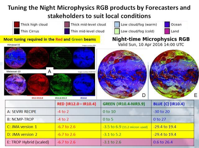
15 The Night Microphysics RGB product compared to the infrared product images courtesy JMA/BOM (Southeastern Australia, 19UTC 27 th January 2017) Melbourne Melbourne Eureka Tower, Melbourne Night Microphysics RGB formula Melbourne image courtesy B.Zeschke

")

16 images courtesy JMA/BOM The advantages of the Night Microphysics RGB product Southeast Australia 20UTC 4 th May 2017 Night Microphysics RGB showing station visibility in meters (yellow) and cloud base height in feet (blue / black) Melbourne short wave infrared (3.9micron) Infrared (10.4 micron)
17 Question to 115 Australian Bureau of Meteorology staff*: How useful have you found the new Himawari-8 data when briefing stakeholders (pilots etc.)? Very useful Useful No satellite data used Have not conducted briefings Other comments 71 * Results to be published in the research paper "How Himawari-8 data has revolutionised the work of Bureau Forecasters", Zeschke et al. 2018

18 image courtesy B.Zeschke The "Hector" thunderstorm of northern Australia
: HRV image -20C Mid-latitude -70C Blending options applied to the upper layer -20C Tropical -80C Upper layer opacity set somewhere between 40 to 75% I have")
19 Some satellite products for the monitoring of Convection: the BOM version of the "Sandwich Product" Upper layer: IR10.4 BT image Bottom layer ( background ): HRV image -20C Mid-latitude -70C Blending options applied to the upper layer -20C Tropical -80C Upper layer opacity set somewhere between 40 to 75% I have chosen 50% for the Sandwich Product, adapted from "Satellite Observations of Storm Tops (part 1)" Martin Setvak, Czech Hydrometeorological Institute


20 Introducing the Day Convection RGB images courtesy JMA Day Convection RGB Range Gamma micron -35 to micron -5 to micron -75 to +20% 1.0 Himawari-8 channels Thin cirrus cloud Large ice particles CHANNEL COMBINATION (mid-latitude EUMETSAT recipe) High level cloud Small ice particles Small ice particles at storm top may indicate severe storms Thin cirrus cloud Small ice particles High level cloud Large ice particles
: HRV image Blending options applied to the upper layer Day Convection RGB (Mid-latitude) Range WV6.2 - WV7.3 BTD -35 to 5 1.0 IR3.9 - IR10.4 BTD -5 to 60 0.")
 Range WV6.2 - WV7.3 BTD -35 to 5 1.0 IR3.9 - IR10.4 BTD -5 to 75 0.33 NIR1.6 - VIS0.6 REFL -75 to 25% 1.")
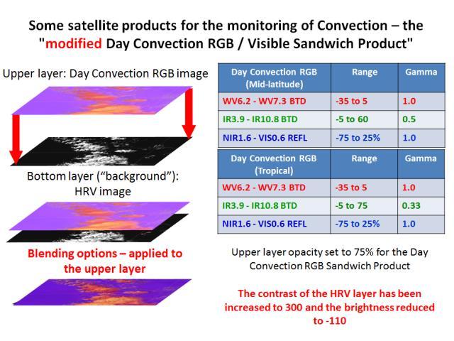
21 Some satellite products for the monitoring of Convection: The Day Convection RGB / Visible Sandwich Product" Upper layer: Day Convection RGB image Bottom layer ( background ): HRV image Blending options applied to the upper layer Day Convection RGB (Mid-latitude) Range WV6.2 - WV7.3 BTD -35 to IR3.9 - IR10.4 BTD -5 to NIR1.6 - VIS0.6 REFL -75 to 25% 1.0 Day Convection RGB (Tropical) Range WV6.2 - WV7.3 BTD -35 to IR3.9 - IR10.4 BTD -5 to NIR1.6 - VIS0.6 REFL -75 to 25% 1.0 Gamma Gamma Upper layer opacity set to 75% for the Day Convection RGB Sandwich Product The contrast of the HRV layer has been increased to 300 and the brightness reduced to -110
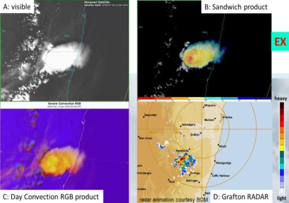
 images courtesy JMA/BOM, lightning data courtesy WeatherZone RADAR image courtesy")
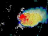
22 East Korea Convective Development, 18 June 2017 Sandwich Product with lightning data, RADAR (QC) and Day Convection RGB Sandwich product (0730 UTC) images courtesy JMA/BOM, lightning data courtesy WeatherZone RADAR image courtesy KMA
 satellite images courtesy JMA/BOM Sokcho no signal detected in the radar Cheongju signal detected in the Himawari-8")
23 RADAR images courtesy Korea Meteorological Administration (KMA) First cumulus field develops in satellite imagery: UTC ( KST) satellite images courtesy JMA/BOM Sokcho no signal detected in the radar Cheongju signal detected in the Himawari-8 data
")
 satellite")

24 RADAR images courtesy Korea Meteorological Administration (KMA) First lightning strikes recorded: UTC ( KST) satellite images courtesy JMA/BOM Sokcho signal detected in both the Himawari-8 and radar data Cheongju

25 images courtesy JMA/BOM Monitoring cloud top temperatures and ice crystal size to determine Tropical Cyclone intensity and development

26 Potentially severe convective outbreak on the flank of the tropical cyclone


27 Question to 115 Australian Bureau of Meteorology staff*: Limitations in the Himawari-8 data 3 Delay in Data Display 34 Large amount of Data / high Data frequency Complexity of Products Colour Vision Deficiency * Results to be published in the research paper "How Himawari-8 data has revolutionised the work of Bureau Forecasters", Zeschke et al. 2018
28 Summary of the session 1 2 The new capabilities of Himawari-8 / 9 True Colour RGB: Volcanic Ash 3 4 Night Microphysics RGB: Fog/Low Cloud Day Convection RGB: Thunderstorms, Tropical Storms

29 ありがとうございます Thank You ありがとうございます Thank You
RGB Experts and Developers Workshop 2017 Tokyo, Japan
 "Application of the Sandwich Product and variations to this as used by Australian Forecasters and as presented during training at the Australian VLab Centre of Excellence". RGB Experts and Developers Workshop
AOMSUC-6 Training Event
 Effective use of high temporal and spatial resolution Himawari-8 data AOMSUC-6 Training Event Bodo Zeschke Australian Bureau of Meteorology Training Centre Australian VLab Centre of Excellence Content
Himawari-8 RGB product use and development amongst Australian / RAV / RAII stakeholders: the Australian VLab Centre of Excellence perspective
 Himawari-8 RGB product use and development amongst Australian / RAV / RAII stakeholders: the Australian VLab Centre of Excellence perspective EUMeTrain Event Week on MTG-I satellite 7-11 November 2016
A Review of the Australian VLab Centre of Excellence National Himawari-8 Training Campaign. AOMSUC-6 Conference Session
 A Review of the Australian VLab Centre of Excellence National Himawari-8 Training Campaign AOMSUC-6 Conference Session Bodo Zeschke Australian Bureau of Meteorology Training Centre Australian VLab Centre
RAV VLab Report Australian VLab Centre of Excellence
 RAV VLab Report Australian VLab Centre of Excellence VLMG-7 Meeting St. Petersburg, 21 25 July 2014 Bodo Zeschke Australian VLab Centre of Excellence Point of Contact Overview of Australian VLab Centre
RGB Products: an easy and practical way to display multispectral satellite data (in combination with derived products)
") RGB Products: an easy and practical way to display multispectral satellite data (in combination with derived products) Dr. Jochen Kerkmann Training Officer EUMETSAT Multi-channel GEO satellites today Him-08
RGB Products: an easy and practical way to display multispectral satellite data (in combination with derived products) Dr. Jochen Kerkmann Training Officer EUMETSAT Multi-channel GEO satellites today Him-08
How to display RGB imagery by SATAID
 How to display RGB imagery by SATAID Akihiro SHIMIZU Meteorological Satellite Center (MSC), Japan Meteorological Agency (JMA) Ver. 2015110500 RGB imagery on SATAID SATAID software has a function of overlapping
NOWCASTING PRODUCTS BASED ON MTSAT-1R RAPID SCAN OBSERVATION. In response to CGMS Action 38.33
 CGMS-39, JMA-WP-08 Prepared by JMA Agenda Item: G.II/8 Discussed in WG II NOWCASTING PRODUCTS BASED ON MTSAT-1R RAPID SCAN OBSERVATION In response to CGMS Action 38.33 This document reports on JMA s MTSAT-1R
Introduction of JMA VLab Support Site on RGB Composite Imagery and tentative RGBs
 The Sixth Asia/Oceania Meteorological Satellite Users' Conference 9 13 November 2015, Tokyo/Japan J M A Introduction of JMA VLab Support Site on RGB Composite Imagery and tentative RGBs Akihiro SHIMIZU
Ash RGB Detection of Volcanic Ash
 Copyright, JMA RGB Detection of Volcanic Meteorological Satellite Center, JMA Ver. 20150424 Volcanic Detection by Infrared and Difference Image, and Basis Himawari-8 B15-B13 2015-02-16 06:35 UTC Himawari-8
Inter-comparison MTSAT-2 & Himawari-8
 Inter-comparison MTSAT-2 & Himawari-8 WMO Volcanic Ash Advisory Centre Best Practice Workshop 2017 Tokyo Volcanic Ash Advisory Centre Japan Meteorological Agency Outline Introduction Method Case study
DISCERNIBLE ASH AND VAA/VAG CONSISTENCY
 WMO VOLCANIC ASH ADVISORY CENTRE BEST PRACTICE WORKSHOP 2017 DISCERNIBLE ASH AND VAA/VAG CONSISTENCY VAAC DARWIN & VAAC TOKYO Presented By: Dr Adele Crozier (VAAC Darwin Manager) VAAC Darwin Discernible
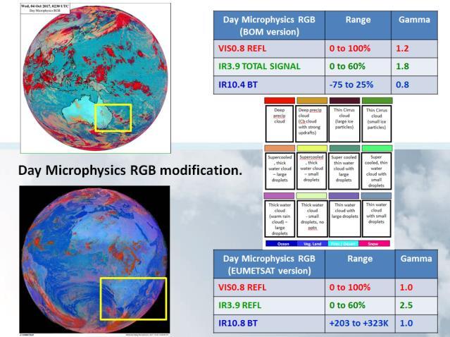
Day Microphysics RGB Nephanalysis in daytime. Meteorological Satellite Center, JMA
 Day Microphysics RGB Nephanalysis in daytime Meteorological Satellite Center, JMA What s Day Microphysics RGB? R : B04 (N1 0.86) Range : 0~100 [%] Gamma : 1.0 G : B07(I4 3.9) (Solar component) Range :
Benefits of the new-generation Himawari-8 geostationary satellite for the Asia-Pacific region. Toshihiko HASHIDA Japan Meteorological Agency (JMA)
") Benefits of the new-generation Himawari-8 geostationary satellite for the Asia-Pacific region Toshihiko HASHIDA Japan Meteorological Agency (JMA) Side Event Ensuring User Readiness to New-Generation Meteorological
Benefits of the new-generation Himawari-8 geostationary satellite for the Asia-Pacific region Toshihiko HASHIDA Japan Meteorological Agency (JMA) Side Event Ensuring User Readiness to New-Generation Meteorological
Day Snow-Fog RGB Detection of low-level clouds and snow/ice covered area
 JMA Day Snow-Fog RGB Detection of low-level clouds and snow/ice covered area Meteorological Satellite Center, JMA What s Day Snow-Fog RGB? R : B04 (N1 0.86) Range : 0~100 [%] Gamma : 1.7 G : B05 (N2 1.6)
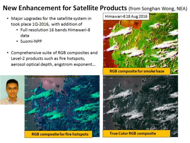
Country Report - Singapore
 Country Report - Singapore The 5th Meeting of the Coordinating Group Vladivostok city, Russky Island, Russia Far Eastern Federal University of the RA II WIGOS Satellite Project 21 October 2017 Outline
Detection and Monitoring Convective Storms by. Using MSG SEVIRI Image. Aydın Gürol ERTÜRK. Contents
 Detection and Monitoring Convective Storms by 1 Using MSG SEVIRI Image Contents MSGView Software Cold U/V and Ring Shape Storm Tops Case Study, 2nd April 2011 Antalya, Türkiye Conclusion Aydın Gürol ERTÜRK
MSGVIEW: AN OPERATIONAL AND TRAINING TOOL TO PROCESS, ANALYZE AND VISUALIZATION OF MSG SEVIRI DATA
 MSGVIEW: AN OPERATIONAL AND TRAINING TOOL TO PROCESS, ANALYZE AND VISUALIZATION OF MSG SEVIRI DATA Aydın Gürol Ertürk Turkish State Meteorological Service, Remote Sensing Division, CC 401, Kalaba Ankara,
Advanced Geostationary Observations for the OzEWEX Community. Leon Majewski Bureau of Meteorology
 Advanced Geostationary Observations for the OzEWEX Community Leon Majewski Bureau of Meteorology Overview Geostationary satellite missions & sensors Meteorological applications Access for OzEWEX researchers
Applications of multi-spectral satellite data
 Applications of multi-spectral satellite data Jochen Kerkmann EUMETSAT, Satellite Meteorologist, Training Officer Adjusted by E de Coning South African Weather Service Content 1. Why should we use RGBs?
Himawari-8 True Color RGB
 Himawari-8 True Color RGB Meteorological Satellite Center, JMA Ver. 20150519 What s True Color RGB? R : B03(VS 0.64) G : B02(V2 0.51) 2015-03-17 00UTC B : B01(V1 0.46) Components of True Color RGB Channel
RGB Experts and Developers Workshop - Introduction Tokyo, Japan 7-9 Nov 2017
 RGB Experts and Developers Workshop - Introduction Tokyo, Japan 7-9 Nov 2017 Workshop Objectives Review of existing RGB standards Reconfirm and extend existing standards (new multi-spectral imagers) Stimulate
Monitoring Sand and Dust Storms from Space
 Monitoring Sand and Dust Storms from Space for Expert Consultation on Disaster Information and Knowledge, Session 2 ICC 21 for ESCAP s RESAP and CDRR 5 9 12 October, 2017 Toshiyuki KURINO WMO Space Programme
4.1 New Generation Satellite Data and Nowcasting Products: Himawari
 4.1 New Generation Satellite Data and Nowcasting Products: Himawari SCOPE-Nowcasting-EP 18-20 September 2017 Koji Yamashita kobo.yamashita@met.kishou.go.jp Meteorological Satellite Center (MSC) Japan Meteorological
Satellite Meteorology. Protecting Life and Property Around the World
 Satellite Meteorology Protecting Life and Property Around the World The Value of Forecasting Severe Weather Flooding events across Europe in August 2002 cost in the region of 20 billion; 20,000 people
Nowcasting of Severe Weather from Satellite Images (for Southern
 Nowcasting of Severe Weather from Satellite Images (for Southern Europe) Petra Mikuš Jurković Forecasting/ nowcasting of convective storms NWP models cannot well predict the exact location and intesity
REPORT ON THE ACTIVITIES OF THE EUMETSAT-ESSL CONVECTION WORKING GROUP
 REPORT ON THE ACTIVITIES OF THE EUMETSAT-ESSL CONVECTION WORKING GROUP Marianne König EUMETSAT, Eumetsat Allee 1, 64295 Darmstadt, Germany Abstract The focus of the Convection Working Group is to have
Current status and plans of JMA operational wind product
 Current status and plans of JMA operational wind product Kazuki Shimoji Japan Meteorological Agency / Meteorological Satellite Center 3-235, Nakakiyoto, Kiyose, Tokyo, Japan Abstract The Meteorological
FUTURE PLAN AND RECENT ACTIVITIES FOR THE JAPANESE FOLLOW-ON GEOSTATIONARY METEOROLOGICAL SATELLITE HIMAWARI-8/9
 FUTURE PLAN AND RECENT ACTIVITIES FOR THE JAPANESE FOLLOW-ON GEOSTATIONARY METEOROLOGICAL SATELLITE HIMAWARI-8/9 Toshiyuki Kurino Japan Meteorological Agency, 1-3-4 Otemachi Chiyodaku, Tokyo 100-8122,
Your Source for Global Aviation Forecasts
 Your Source for Global Aviation Forecasts (831) 238-5054 100 Sky Park Drive Monterey, CA 93940 Weather4Cast.com Live Weather Data Feeds Weather4Cast.com provides Live Aviation Weather Data Feeds formatted
Rapidly Developing Cumulus Area RDCA detection using Himawari-8 data
 AOMSUC-7@Incheon Rapidly Developing Cumulus Area RDCA detection using Himawari-8 data Hiroshi SUZUE and Yasuhiko SUMIDA Meteorological Satellite Center Japan Meteorological Agency Contents Ø Outline of
Overview of Himawari-8/9
 Overview of Himawari-8/9 Toshiyuki SAKURAI Meteorological Satellite Center (MSC) Japan Meteorological Agency (JMA) EUMeTrain Event Week on MTG-I Satellite 2016 Session2 - Himawari-8 and Data Applications
Preparation for Himawari 8
 Preparation for Himawari 8 Japan Meteorological Agency Meteorological Satellite Center Hidehiko MURATA ET SUP 8, WMO HQ, Geneva, 14 17 April 2014 1/18 Introduction Background The Japan Meteorological Agency
Report on the SCOPE-Nowcasting Pilot Projects January 2017
 Report on the SCOPE-Nowcasting Pilot Projects January 2017 The aim of the Sustained, Co-Ordinated Processing of Environmental Satellite Data for Nowcasting (SCOPE-Nowcasting) initiative is to provide consistent
Recommendations from RA III/RA IV SDR -2 Training Task Team (SDR-TTT)
") WORLD METEOROLOGICAL ORGANIZATION COORDINATION GROUP ON SATELLITE DATA REQUIREMENTS FOR REGION III AND IV Recommendations from RA III/RA IV SDR -2 Training Task Team (SDR-TTT) KATHY-ANN CAESAR CARIBBEAN
WORLD METEOROLOGICAL ORGANIZATION COORDINATION GROUP ON SATELLITE DATA REQUIREMENTS FOR REGION III AND IV Recommendations from RA III/RA IV SDR -2 Training Task Team (SDR-TTT) KATHY-ANN CAESAR CARIBBEAN
OVERSHOOTING TOPS CHARACTERISTICS AND PROPERTIES
 OVERSHOOTING TOPS CHARACTERISTICS AND PROPERTIES Michaela Valachová 1,2, Martin Setvák 2, Jindřich Šťástka 1,2 1 Charles University in Prague, Faculty of Mathematics and Physics, Department of Meteorology
YELLOW SPOT IN THE CONVECTIVE STORMS RGB IMAGE CAUSED BY A PILEUS CLOUD
 YELLOW SPOT IN THE CONVECTIVE STORMS RGB IMAGE CAUSED BY A PILEUS CLOUD André Simon, Mária Putsay, Ildikó Szenyán and Ákos Horváth Hungarian Meteorological Service, Kitaibel Pál u. 1, H-1024 Budapest,
Satellite observation of atmospheric dust
 Satellite observation of atmospheric dust Taichu Y. Tanaka Meteorological Research Institute, Japan Meteorological Agency 11 April 2017, SDS WAS: Dust observation and modeling @WMO, Geneva Dust observations
Satellite Data Utilisation at the National Meteorological Service of New Zealand (MetService) Wim van Dijk November 2015 AOMSUC6 SC 2-4
 Wim van Dijk November 2015 AOMSUC6 SC 2-4") Satellite Data Utilisation at the National Meteorological Service of New Zealand (MetService) Wim van Dijk November 2015 AOMSUC6 SC 2-4 Forecasting at MetService MetService currently employs ~275 staff
Satellite Data Utilisation at the National Meteorological Service of New Zealand (MetService) Wim van Dijk November 2015 AOMSUC6 SC 2-4 Forecasting at MetService MetService currently employs ~275 staff
JMA s ATMOSPHERIC MOTION VECTORS In response to Action 40.22
 5 July 2013 Prepared by JMA Agenda Item: II/6 Discussed in WG II JMA s ATMOSPHERIC MOTION VECTORS In response to Action 40.22 This paper reports on the recent status of JMA's AMVs from MTSAT-2 and MTSAT-1R,
HIGH SPATIAL AND TEMPORAL RESOLUTION ATMOSPHERIC MOTION VECTORS GENERATION, ERROR CHARACTERIZATION AND ASSIMILATION
 HIGH SPATIAL AND TEMPORAL RESOLUTION ATMOSPHERIC MOTION VECTORS GENERATION, ERROR CHARACTERIZATION AND ASSIMILATION John Le Marshall Director, JCSDA 2004-2007 CAWCR 2007-2010 John Le Marshall 1,2, Rolf
Czech Hydrometeorological Institute, Na Šabatce 17, CZ Praha 4, Czech Republic. 3
 MOISTURE DETECTION ABOVE CONVECTIVE STORMS UTILIZING THE METHOD OF BRIGHTNESS TEMPERATURE DIFFERENCES BETWEEN WATER VAPOR AND IR WINDOW BANDS, BASED ON 2008 MSG RAPID SCAN SERVICE DATA Jindřich Šťástka1,2,
Joint RA II/V Workshop on WIGOS for DRR - The Jakarta Declaration - (12-14 October, Jakarta, Indonesia) NMSC/KMA
 NMSC/KMA") Joint RA II/V Workshop on WIGOS for DRR - The Jakarta Declaration - (12-14 October, Jakarta, Indonesia) /KMA dolong@korea.kr Background Enhancement of Member s capabilities for weather forecasts and warnings
Joint RA II/V Workshop on WIGOS for DRR - The Jakarta Declaration - (12-14 October, Jakarta, Indonesia) /KMA dolong@korea.kr Background Enhancement of Member s capabilities for weather forecasts and warnings
Fog detection product
 Fog detection product derived from RGB recipes Takumi Maruyama, Haruma Ishida and Koetsu Chubachi Meteorological Satellite Center / Japan Meteorological Agency Meteorological Research Institute / Japan
Satellite-based Convection Nowcasting and Aviation Turbulence Applications
 Satellite-based Convection Nowcasting and Aviation Turbulence Applications Kristopher Bedka Cooperative Institute for Meteorological Satellite Studies (CIMSS), University of Wisconsin-Madison In collaboration
SATELLITE MONITORING OF THE CONVECTIVE STORMS
 SATELLITE MONITORING OF THE CONVECTIVE STORMS FORECASTERS POINT OF VIEW Michaela Valachová, EUMETSAT Workshop at ECMWF User Meeting Reading, 13 June 2017 Central Forecasting Office, Prague michaela.valachova@chmi.cz
INTERPRETATION OF MSG IMAGES, PRODUCTS AND SAFNWC OUTPUTS FOR DUTY FORECASTERS
 INTERPRETATION OF MSG IMAGES, PRODUCTS AND SAFNWC OUTPUTS FOR DUTY FORECASTERS M. Putsay, M. Rajnai, M. Diószeghy, J. Kerényi, I.G. Szenyán and S. Kertész Hungarian Meteorological Service, H-1525 Budapest,
Volcanic Sulphur Dioxide
 Volcanic Sulphur Dioxide Overview Background & context Claire Witham VAAC SO 2 forecast demonstration Dov Bensimon Rolls Royce work on SO2 Rory Clarkson New capabilities to remotely sense SO2 - Marcel
Applications of the SEVIRI window channels in the infrared.
 Applications of the SEVIRI window channels in the infrared jose.prieto@eumetsat.int SEVIRI CHANNELS Properties Channel Cloud Gases Application HRV 0.7 Absorption Scattering
Development of an ensemble-based volcanic ash dispersion model for operations at Darwin VAAC
 Development of an ensemble-based volcanic ash dispersion model for operations at Darwin VAAC Rodney Potts Bureau of Meteorology Australia [C Lucas, R Dare, M Manickam, A Wain, M Zidikheri, A Bear-Crozier]
INTERNATIONAL AIRWAYS VOLCANO WATCH OPERATIONS GROUP (IAVWOPSG)
") International Civil Aviation Organization IAVWOPSG/6-WP/29 4/8/11 WORKING PAPER INTERNATIONAL AIRWAYS VOLCANO WATCH OPERATIONS GROUP (IAVWOPSG) SIXTH MEETING Dakar, Senegal, 19 to 23 September 2011 Agenda
International Civil Aviation Organization IAVWOPSG/6-WP/29 4/8/11 WORKING PAPER INTERNATIONAL AIRWAYS VOLCANO WATCH OPERATIONS GROUP (IAVWOPSG) SIXTH MEETING Dakar, Senegal, 19 to 23 September 2011 Agenda
A Questionnaire on the Utilization of Satellite Data from the New Generation of Geostationary Meteorological Satellites
 3.1 User requirements for satellite data utilization, especially for new-generation satellites A Questionnaire on the Utilization of Satellite Data from the New Generation of Geostationary Meteorological
MSG FOR NOWCASTING - EXPERIENCES OVER SOUTHERN AFRICA
 MSG FOR NOWCASTING - EXPERIENCES OVER SOUTHERN AFRICA Estelle de Coning and Marianne König South African Weather Service, Private Bag X097, Pretoria 0001, South Africa EUMETSAT, Am Kavalleriesand 31, D-64295
ESTIMATION OF THE SEA SURFACE WIND IN THE VICINITY OF TYPHOON USING HIMAWARI-8 LOW-LEVEL AMVS
 Proceedings for the 13 th International Winds Workshop 27 June - 1 July 2016, Monterey, California, USA ESTIMATION OF THE SEA SURFACE WIND IN THE VICINITY OF TYPHOON USING HIMAWARI-8 LOW-LEVEL AMVS Kenichi
NOAA s National Weather Service VAAC Anchorage. Don Moore
 NOAA s National Weather Service VAAC Anchorage Don Moore VAAC Best Practices Workshop May 2015 Volcanic Eruptions Volcanic Eruptions Volcanic Eruptions VAAC Anchorage and Alaska Aviation Weather Unit (AAWU)
Satellite data for African applications
 Satellite data for African applications Henk Verschuur, EUMETSAT henk.verschuur@eumetsat.int Introduction Some examples of satellite products which are useful for Africa Satellite products Tropical cyclones
Aviation Hazards: Thunderstorms and Deep Convection
 Aviation Hazards: Thunderstorms and Deep Convection TREND Diagnosis of thunderstorm hazards using imagery Contents Satellite imagery Visible, infrared, water vapour Basic cloud identification Identifying
1. History and Current Status
 Contents 1. History and Current Status History and Mission Image acquisition and Dissemination Products 2. Future Plan Schedule Mission of Himawari 8/9 Development of Products Data Dissemination 0 1. History
JMA s atmospheric motion vectors
 Prepared by JMA Agenda Item: WG II/6 Discussed in WG II JMA s atmospheric motion vectors This paper reports on the recent status of JMA's Atmospheric Motion Vectors (AMVs) from MTSAT-2 and MTSAT-1R, and
OPTIMISING THE TEMPORAL AVERAGING PERIOD OF POINT SURFACE SOLAR RESOURCE MEASUREMENTS FOR CORRELATION WITH AREAL SATELLITE ESTIMATES
 OPTIMISING THE TEMPORAL AVERAGING PERIOD OF POINT SURFACE SOLAR RESOURCE MEASUREMENTS FOR CORRELATION WITH AREAL SATELLITE ESTIMATES Ian Grant Anja Schubert Australian Bureau of Meteorology GPO Box 1289
An overview of Wet Season Forecasting in the Northern Territory
 TWP-ICE Meeting November 2004 An overview of Wet Season Forecasting in the Northern Territory Lori Chappel Northern Territory Regional Forecasting Centre Australian Government Bureau of Meteorology Day
MSG Indian Ocean Data Coverage (IODC) Jochen Grandell & Sauli Joro
 Jochen Grandell & Sauli Joro") MSG Indian Ocean Data Coverage (IODC) Jochen Grandell & Sauli Joro 1 EUM/STG-SWG/42/17/VWG/03 v1, 7 8 Mach 2017 Topics Introduction MSG-IODC Overall Project Schedule Status Product validation Products
MSG Indian Ocean Data Coverage (IODC) Jochen Grandell & Sauli Joro 1 EUM/STG-SWG/42/17/VWG/03 v1, 7 8 Mach 2017 Topics Introduction MSG-IODC Overall Project Schedule Status Product validation Products
PHEOS - Weather, Climate, Air Quality
 Aerosol & cloud remote sensing over the Arctic : perspectives for the PHEMOS and meteorological imager payloads on the PCW mission Norm O Neill, Auromeet Saha, U. de Sherbrooke Chris E. Sioris, Jack McConnell,
P3.24 EVALUATION OF MODERATE-RESOLUTION IMAGING SPECTRORADIOMETER (MODIS) SHORTWAVE INFRARED BANDS FOR OPTIMUM NIGHTTIME FOG DETECTION
 SHORTWAVE INFRARED BANDS FOR OPTIMUM NIGHTTIME FOG DETECTION") P3.24 EVALUATION OF MODERATE-RESOLUTION IMAGING SPECTRORADIOMETER (MODIS) SHORTWAVE INFRARED BANDS FOR OPTIMUM NIGHTTIME FOG DETECTION 1. INTRODUCTION Gary P. Ellrod * NOAA/NESDIS/ORA Camp Springs, MD
P3.24 EVALUATION OF MODERATE-RESOLUTION IMAGING SPECTRORADIOMETER (MODIS) SHORTWAVE INFRARED BANDS FOR OPTIMUM NIGHTTIME FOG DETECTION 1. INTRODUCTION Gary P. Ellrod * NOAA/NESDIS/ORA Camp Springs, MD
The Eyjafjallajokull Volcanic Ash Cloud and its Effects on Scottish Air Quality. Update 06 May 2010
 The Eyjafjallajokull Volcanic Ash Cloud and its Effects on Scottish Air Quality. Update 06 May 2010 The volcanic ash cloud from the Eyjafjallakull volcano once again grounded flights from Scottish airports
Himawari 8/9 data distribution/dissemination plan
 Himawari 8/9 data distribution/dissemination plan Japan Meteorological Agency (JMA) Hidehiko MURATA Himawari is the name of this flower in Japanese ET SUP 8, WMO HQ, Geneva, 14 17 April 2014 1 Outline
Satellites, Weather and Climate Module 1: Introduction to the Electromagnetic Spectrum
 Satellites, Weather and Climate Module 1: Introduction to the Electromagnetic Spectrum What is remote sensing? = science & art of obtaining information through data analysis, such that the device is not
WMO SCOPE-Nowcasting using new-generation satellite data: Progress and Perspectives
 WMO SCOPE-Nowcasting using new-generation satellite data: Progress and Perspectives Stephan Bojinski WMO Space Programme 8 th Asia-Oceania Meteorological Satellite Users Conference Vladivostok, Russia,
HARMONISING SEVIRI RGB COMPOSITES FOR OPERATIONAL FORECASTING
 HARMONISING SEVIRI RGB COMPOSITES FOR OPERATIONAL FORECASTING HansPeter Roesli (1), Jochen Kerkmann (1), Daniel Rosenfeld (2) (1) EUMETSAT, Darmstadt DE, (2) The Hebrew University of Jerusalem, Jerusalem
Wildfire WG Monitoring of Heat Related Disaster using Volcano and Wildfire monitoring system
 Wildfire WG Monitoring of Heat Related Disaster using monitoring system 2018 11 01 Koji Nakau, JAXA/SAOC Topics Fire danger related indexes monitoring system Volcano monitoring Although this is Wildfire
Himawari 8: Experiences and Lessons Learned. Daisaku Uesawa Meteorological Satellite Center (MSC) Japan Meteorological Agency (JMA)
 Japan Meteorological Agency (JMA)") Himawari 8: Experiences and Lessons Learned Daisaku Uesawa Meteorological Satellite Center (MSC) Japan Meteorological Agency (JMA) IPET SUP 2, GENEVA, SWITZERLAND, 23 26 FEBRUARY 2016 1 Himawari-8 operation
Himawari 8: Experiences and Lessons Learned Daisaku Uesawa Meteorological Satellite Center (MSC) Japan Meteorological Agency (JMA) IPET SUP 2, GENEVA, SWITZERLAND, 23 26 FEBRUARY 2016 1 Himawari-8 operation
Operational Generation And Assimilation Of Himawari-8. Atmospheric Motion Vectors
 Operational Generation And Assimilation Of Himawari-8 Atmospheric Motion Vectors John Le Marshall 1, David Howard 1, Xingbao Wang 1, Yi Xiao 1, Jim Jung 2, Jaime Daniels 4,Steve Wanzong 2, Joan Fernon
JOINT WMO TECHNICAL PROGRESS REPORT ON THE GLOBAL DATA PROCESSING AND FORECASTING SYSTEM AND NUMERICAL WEATHER PREDICTION RESEARCH ACTIVITIES FOR 2016
 JOINT WMO TECHNICAL PROGRESS REPORT ON THE GLOBAL DATA PROCESSING AND FORECASTING SYSTEM AND NUMERICAL WEATHER PREDICTION RESEARCH ACTIVITIES FOR 2016 New Zealand / Meteorological Service of New Zealand
JMA Contribution to SWFDDP in RA-V
 JMA Contribution to SWFDDP in RA-V Yoshihiko TAHARA (Mr.) Japan Meteorological Agency (JMA) y-tahara@met.kishou.go.jp Meeting of the Regional Subproject Management Team (RSMT) of the Severe Weather Forecasting
Dispersion modelling and warnings for volcanic ash in the Australian Region
 Dispersion modelling and warnings for volcanic ash in the Australian Region R Potts, R Dare, E Jansons, C Lucas, A Tupper, M Zidikheri The Centre for Australian Weather and Climate Research A partnership
EUMETSAT products and services for monitoring storms - New missions, more data and more meteorological products
 EUMETSAT products and services for monitoring storms - New missions, more data and more meteorological products Jochen Grandell 1 EUM/RSP/VWG/17/921460 Outline Overview of EUMETSAT missions Current...and
TC intensity estimation using Satellite data at JMA
 SECOND INTERNATIONAL WORKSHOP ON SATELLITE ANALYSIS OF TROPICAL CYCLONES (IWSATC-II) TC intensity estimation using Satellite data at JMA Topics: 1) Estimation of TC central pressure using Microwave Sounder
RA II WIGOS Project Newsletter
 Vol. 9 No. 1, March 2018 RA II WIGOS Project Newsletter DEVELOPING SUPPORT FOR NATIONAL METEOROLOGICAL AND HYDROLOGICAL SERVICES IN SATELLITE DATA, PRODUCTS AND TRAINING Contents of this issue Page Launch
Current capabilities and limitations of satellite monitoring and modeling forecasting of volcanic clouds: and example of Eyjafjallaj
 Current capabilities and limitations of satellite monitoring and modeling forecasting of volcanic clouds: and example of Eyjafjallaj fjallajökull eruption (pronounced EYE-a-fyat fyat-la-jo-kotl) N. Krotkov
(Country Report) [1]
![(Country Report) [1]](/thumbs/95/124397460.jpg "(Country Report) [1]") (Country Report) [1] VANUATU METEOROLOGY AND GEO-HAZARDS DEPARTENT Private Mail Bag 9054 Port Vila Vanuatu (678) 24686 Email: admin@meteo.gov.vu, forecast@meteo.gov.vu Jerry Natugogona (Senior Forecaster)
(Country Report) [1] VANUATU METEOROLOGY AND GEO-HAZARDS DEPARTENT Private Mail Bag 9054 Port Vila Vanuatu (678) 24686 Email: admin@meteo.gov.vu, forecast@meteo.gov.vu Jerry Natugogona (Senior Forecaster)
2 More Science Cases, Summary & Close
 2 More Science Cases, Summary & Close Chris Packham University of Texas at San Antonio On behalf of the MICHI team Physics&Astronomy THE UNIVERSITY OF TEXAS AT SAN ANTONIO ! Giant Planets - Giant Problems!
Volcanic eruptions: Introduction to remote sensing techniques for fine ash and SO2 detection
 Volcanic eruptions: Introduction to remote sensing techniques for fine ash and SO2 detection Bernie Connell Cooperative Institute for Research in the Atmosphere Colorado State University USA Ash clouds
Moisture, Clouds, and Precipitation: Clouds and Precipitation. Dr. Michael J Passow
 Moisture, Clouds, and Precipitation: Clouds and Precipitation Dr. Michael J Passow What Processes Lift Air? Clouds require three things: water vapor, a condensation nucleus, and cooling Cooling usually
SATELLITE SIGNATURES ASSOCIATED WITH SIGNIFICANT CONVECTIVELY-INDUCED TURBULENCE EVENTS
 SATELLITE SIGNATURES ASSOCIATED WITH SIGNIFICANT CONVECTIVELY-INDUCED TURBULENCE EVENTS Kristopher Bedka 1, Wayne Feltz 1, John Mecikalski 2, Robert Sharman 3, Annelise Lenz 1, and Jordan Gerth 1 1 Cooperative
METEOSAT CONVECTIVE INITIATION PRODUCT WITH AND WITHOUT CLOUD TRACKING - EXPERIENCES
 METEOSAT CONVECTIVE INITIATION PRODUCT WITH AND WITHOUT CLOUD TRACKING - EXPERIENCES Mária Putsay 1, Zsófia Kocsis 1, Marianne König 2, Ildikó Szenyán 1, Márta Diószeghy 1, André Simon 1 and Márk Rajnai
Current Status of COMS AMV in NMSC/KMA
 Current Status of COMS AMV in NMSC/KMA Eunha Sohn, Sung-Rae Chung, Jong-Seo Park Satellite Analysis Division, NMSC/KMA soneh0431@korea.kr COMS AMV of KMA/NMSC has been produced hourly since April 1, 2011.
Rapidly Developing Thunderstorm (RDT)
") Rapidly Developing Thunderstorm (RDT) Jean-Marc Moisselin, Frédéric Autones Météo-France Nowcasting Department 42, av. Gaspard Coriolis 31057 Toulouse France jean-marc.moisselin@meteo.fr EUMETRAIN Convection
Rapidly Developing Thunderstorm (RDT) Jean-Marc Moisselin, Frédéric Autones Météo-France Nowcasting Department 42, av. Gaspard Coriolis 31057 Toulouse France jean-marc.moisselin@meteo.fr EUMETRAIN Convection
The use of Direct Broadcast Processing System in Poland
 The use of Direct Broadcast Processing System in Poland B.Łapeta, P.Struzik Satellite Remote Sensing Department, Institute of Meteortology and Water Management National Reasearch Institute About IMWM-NRI
Atmospheric Motions Derived From Space Based Measurements: A Look To The Near Future. James F.W. Purdom
 Atmospheric Motions Derived From Space Based Measurements: A Look To The Near Future James F.W. Purdom Director, Office of Research and Applications NOAA/NESDIS 1. Introduction This short note addresses
GENERATION OF HIMAWARI-8 AMVs USING THE FUTURE MTG AMV PROCESSOR
 GENERATION OF HIMAWARI-8 AMVs USING THE FUTURE MTG AMV PROCESSOR Manuel Carranza 1, Régis Borde 2, Masahiro Hayashi 3 1 GMV Aerospace and Defence S.A. at EUMETSAT, Eumetsat Allee 1, D-64295 Darmstadt,
Development of a System for Quantitatively Analyzing Volcanic Clouds
 Development of a System for Quantitatively Analyzing Volcanic Clouds Michael Pavolonis (NOAA/NESDIS/STAR) Justin Sieglaff and John Cintineo (UW-CIMSS) Marco Fulle - www.stromboli.net 2 nd IUGG-WMO Workshop
Arctic Weather Every 10 Minutes: Design & Operation of ABI for PCW
 Arctic Weather Every 10 Minutes: Design and Operation of ABI for PCW Dr. Paul C. Griffith and Sue Wirth 31st Space Symposium, Technical Track, Colorado Springs, Colorado This document is not subject to
The 5th Meeting of the Coordinating Group of the RA II WIGOS Satellite Project
 The 5th Meeting of the Coordinating Group of the RA II WIGOS Satellite Project 21 October, Vladivostok city, Russky Island, Russia Far Eastern Federal University Hong Kong, China Mr. C.K.So, Scientific
Development of volcanic ash product for the next-generation Japanese Geostationary Meteorological Satellite Himawari-8
 Development of volcanic ash product for the next-generation Japanese Geostationary Meteorological Satellite Himawari-8 Hiroaki Tsuchiyama 1, Yukio Kurihara 1, Kazuhiko Masuda 2 (1) Japan Meteorological
CURRENT STATUS OF OPERATIONAL WIND PRODUCT IN JMA/MSC
 Proceedings for the 13 th International Winds Workshop 27 June - 1 July 2016, Monterey, California, USA CURRENT STATUS OF OPERATIONAL WIND PRODUCT IN JMA/MSC Kazuki Shimoji and Kenichi Nonaka JMA/MSC,
COUNTRY REPORT INDONESIA
 COUNTRY REPORT INDONESIA Badan Meteorologi Klimatologi dan Geofisika (BMKG) Agency For Meteorology, Climatology, and Geophysics Republic of Indonesia DKI Jakarta, Indonesia Tel. (021) 4246321 Email: pcs@bmkg.go.id
Sand and Dust Monitoring in RA II
 Sand and Dust Monitoring in RA II Xiang Fang National Satellite Meteorological Center,CMA Outline Dust products in RA II Validation of multi-satellite products Action Proposed Dust products in RA II Operational
COLD-RING AND COLD-U/V SHAPED STORMS
 MARTIN SETVÁK setvak@chmi.cz Czech Hydrometeorological Institute, Prague COLD-RING AND COLD-U/V SHAPED STORMS Version : 18 May 2009 What are the cold-ring and cold-u/v shaped storms? Appearance and terminology
RECENT ADVANCES TO EXPERIMENTAL GMS ATMOSPHERIC MOTION VECTOR PROCESSING SYSTEM AT MSC/JMA
 RECENT ADVANCES TO EXPERIMENTAL GMS ATMOSPHERIC MOTION VECTOR PROCESSING SYSTEM AT MSC/JMA Ryoji Kumabe 1, Yoshiki Kajino 1 and Masami Tokuno 2 1 Meteorological Satellite Center, Japan Meteorological Agency
New capabilities with high resolution cloud micro-structure facilitated by MTG 2.3 um channel
 Slide 19 November 2016, V1.0 New capabilities with high resolution cloud micro-structure facilitated by MTG 2.3 um channel Author: Daniel Rosenfeld The Hebrew University of Jerusalem (HUJ) daniel.rosenfeld@huji.ac.il