Operational Generation And Assimilation Of Himawari-8. Atmospheric Motion Vectors
|
|
|
- Osborne Ellis
- 5 years ago
- Views:
Transcription

1 Operational Generation And Assimilation Of Himawari-8 Atmospheric Motion Vectors John Le Marshall 1, David Howard 1, Xingbao Wang 1, Yi Xiao 1, Jim Jung 2, Jaime Daniels 4,Steve Wanzong 2, Joan Fernon 1, Agnes Lim 2, Wayne Bresky 5, Andrew Bailey 5 Chris Tingwell 1, Robert Norman 3 Tim Morrow 1 1 Bureau of Meteorology, Melbourne, Australia 2 UW/CIMSS, Madison,USA 3 RMIT University, Melbourne, Australia 4 NOAA/NESDIS/STAR, College Park, USA 5 IMSG
2 Overview Importance of EOS Improvements in specification of the mass and wind field AMVs- MTSat -1R, -2 Himawari 8, Himawari 9 Future Conclusions
 28 October to 30 November 2011 GFS (2010) - Operational data base (US Op.")
3 The Importance of EOS ( in the SH) Observing System Experiments (OSEs) With and Without Satellite Data Systems Examined ACCESS (APS1) Operational data base (Australian Op. Sys) 28 October to 30 November 2011 GFS (2010) - Operational data base (US Op. Sys) 15 August to 30 September 2010
4 Earth Observations From Space AC: 500hPa HGT SAT NOSAT AC: 500hPa HGT NOSAT SAT AC 0.8 AC HOURS HOURS Fig. 8(c). SH 500hPa height anomaly correlation for the control (SAT) and no satellite (NOSAT), 28 October to 30 November 2011 using ACCESS and verifying against the control analysis Fig. 8(f). NH 500hPa height anomaly correlation for the control (SAT) and no satellite (NOSAT), 28 October to 30 November 2011 using ACCESS and verifying against the control analysis


 Hanssen and Kuipers (Aust. Region) 0.282 0.")
5 Hi Impact Weather ACCESS-G 48 to 72 hour rainfall forecast for 9 November 2011 using satellite data. ACCESS-G 48 to 72 hour rainfall forecast for 9 November 2011 using no satellite data. Daily rain gauge analysis for 9 November November 2011 NOSAT SAT Correlation between observed and forecast rainfall (Aust. Region) Hanssen and Kuipers (Aust. Region) Daily rainfall values.
6 Hi Impact Weather Track Error [NM] Atlantic Basin Hurricane Track Mean Errors Forecast Time [hours] Storm Counts Control No_satellite Atlantic basin mean hurricane track errors for the control (all data) and no satellite data case, 15 August to 30 September 2010 using GFS and verifying against the control (all data) analysis.


7 Specification of the Mass and Wind Field Key Data AMVs Ultraspectral Advanced Sounders AIRS IASI CrIS GPS RO

8 ACCESS APS2: Forecast Sensitivity to Observations Colours: Satellite Upper air network Surface network Global 24-hour forecast error reduction from each of the observation types assimilated in ACCESS Three months: April, May and June Himawari-8 AMVs included in full period. All types of observations are beneficial, i.e. reduce the forecast error. Total impact (LH panel) is dominated by satellite instruments (e.g. the IASI, AMSU and CrIS sounding instruments carried on polar orbiters and AMVs) - due to large numbers & global coverage. Greater impact per observation (RH panel) comes from balloon upper air measurements plus surface measurements from drifting and fixed buoys.
9 MTSAT -1R and 2 Himawari-8 Himawari-9 THE GENERATION AND ASSIMILATION OF CONTINUOUS ATMOSPHERIC MOTION VECTORS WITH 4DVAR
![Specification of Himawari-8/9 Imager(AHI) Full Disk Image every 10 minutes X X X X X X X X X X X Band Central Wavelength [μm] Spatial Resolution 1 0.43-0.48 1Km 2 0.50-0.52 1Km 3 0.63-0.66 0.5Km 4 0.](/docs-images/90/102410213/images/10-0.jpg "85-0.87 1Km 5 1.60-1.62 2Km 6 2.25-2.27 2Km 7 3.74-3.96 2Km 8 6.06-6.43 2Km 9 6.89-7.01 2Km 10 7.26-7.43 2Km 11 8.44-8.76 2Km 12 9.54-9.72 2Km 13 10.3-10.6 2Km 14 11.1-11.3 2Km 15 12.2-12.5 2Km 16 13.")
10 Specification of Himawari-8/9 Imager(AHI) Full Disk Image every 10 minutes X X X X X X X X X X X Band Central Wavelength [μm] Spatial Resolution Km Km Km Km Km Km Km Km Km Km Km Km Km Km Km Km RGB Composited True Color Image 1.3 μm for GOES-R Water Vapour SO2 O3 Atmospheric Windows CO2 MTSAT-1R/2 Band Central Wavelength [μm] Spatial Resolution Km Km Km Km Km

11 H 7 AMVS MTSAT 2

12 27 January 23 February 2011 Used Real Time Local Satellite Winds MTSAT-2 (EE, hourly since 96, TDB) 2 sets of quarter hourly motion vectors every six hours. Hourly motion Vectors Operational Regional NEAR RT TRIAL OPERATIONAL SYSTEM Forecast Model (ACCESS-R) and Data Base ( Inc JMA AMVs)
13 HIMAWARI-7 NEAR RT TRIAL Fig.6(a). The RMS difference between forecast and verifying analysis geopotential height(m) at 24 hours for ACCESS-R (green) and ACCESS-R with hourly AMVs (red) for the period 27 January to 23 February Fig.6(b). The RMS difference between forecast and verifying analysis geopotential height(m) at 48 hours for ACCESS-R (green) and ACCESS-R with hourly AMVs (red) for the period 27 January to 23 February 2011.
14 Table 6 : The SI skill scores for the hourly IR and VIS CDW assimilation (CLAPS2) and matching control Forecasts (CLAPS1) for the period and 05 September to 08 December June, :18 EUHSTCV 2 ( IWW3 ) Period 05 September to 25 September 1995 Level MSLP 850 hpa 500 hpa 300 hpa Assim. Type No. of cases Skill score CLAPS1 CLAPS2 CLAPS1 CLAPS2 CLAPS1 CLAPS2 CLAPS1 CLAPS Period 03 December to 08 December 1995 Level MSLP 850 hpa 500 hpa 300 hpa Assim. Type No. of cases Skill score CLAPS1 CLAPS2 CLAPS1 CLAPS2 CLAPS1 CLAPS2 CLAPS1 CLAPS
15 GENERATION AND ASSIMILATION OF CONTINUOUS (10 Minute) ATMOSPHERIC MOTION VECTORS FROM MTSAT-1R (HIMAWARI-6) USING 4DVAR

16 Fig. 1 A selection of Himawari-6 Atmospheric Motion Vectors over North-Eastern Australia generated from 10 min imagery between 0010 UTC and 0050 UTC 28 January 2014.
 forecast valid 1200 UTC 30 January 2014, shown remapped over an MTSat infrared image, valid at the same time. Fig.")
17 10Min First Results MTSAT-1R Fig. 13 Bureau of Meteorology Analysis for 12 UTC on 27 January Fig. 14. Bureau of Meteorology Analysis for 12 UTC on 30 January 2014 APS-1 APS-2 Fig.15 The Bureau of Meteorology operational three-day MSLP (hpa) forecast valid 1200 UTC 30 January 2014, shown remapped over an MTSat infrared image, valid at the same time. Fig.16 The Bureau of Meteorology three-day MSLP (hpa) forecast valid, 1200 UTC 30 January 2014 using the next generation operational regional forecasting system with ten, fifteen and sixty minute AMV data from MTSat-1R and MTSat-2. The forecast remapped over the 1200 UTC MTSat image.
 H-8 (9) ATMOSPHERIC MOTION VECTORS, With GEOCAT")
18 RECENT GENERATION AND ASSIMILATION OF CONTINUOUS (10 Minute) H-8 (9) ATMOSPHERIC MOTION VECTORS, With GEOCAT AND 4DVAR
19 Himawari-8 Operational AMV Generation Uses all image triplets (separated by 10 min in HSF format). Employs modified GEOCAT (Geostationary Cloud Algorithm Testbed) software in initial processing. Height assignment methods similar to GOES-R ABI ATBD For Cloud Height (Heidinger, A. 2010) AMV estimation is similar to GOES-R ABI ATBD for Derived Motion Winds (Daniels, 2010) / BoM system Error characterization, data selection, QC via EE, QI, ERR etc. (Le Marshall et al., 2004, 2015) Height assignment verification Cloudsat/Calipso, RAOBS (System also used for H-7)

20
21

22 00UTC 17 April 2018


23 Fig.7 AMVs generated around Australia 0000UTC 29 April 2015 Note box around Australia. Fig.8 AMVs generated around Australia 0000UTC 29 April 2015 View from the south. Fig.9AMVs generated around Australia 0000UTC 29 April 2015 View from the west. Fig.10AMVs generated around Australia 0000UTC 29 April 2015 Slant view from southwest.
24 Table 1 Verification Table for Himawari-8 IR (Channel 14) AMVs compared to radiosondes 1 March - 31 March 2017 AMV Type Category m/s NOBS Table 2 Verification Table for Himawari-8 VIS (Channel 3) AMVs compared to radiosondes 1 March - 31 March 2017 AMV Type Category m/s NOBS Low Sep <50 km MMVD RMSVD Low Sep <50 km MMVD RMSVD BIAS BIAS High Sep <50 km MMVD RMSVD High Sep <50 km MMVD RMSVD BIAS BIAS Processing every 10 minutes
25 Length Scale of the Correlated Error The correlation function used was the second order auto-regressive (SOAR) function (Daley 1991), namely R(r) = R 00 + R 0 (1 + r/l) e r/l, where R(r) is the error correlation, with fitting parameters R 00, R 0 (greater than 0), and L is the length scale, and 'r' is the separation of the correlates. Initial parameter estimates derived using the methods referenced in Le Marshall, 2004 (for example for low level Ch14 AMVs; L=128, R 0 =0.56 and R 00 = 0.01) are not inconsistent with the current analysis method. These estimates are still being improved as the match database being used is expanding rapidly.
 vs Expected Error (m/s) for low-level Himawari-8 IR winds (1 31 August 29 2016).")

26 Fig.3 Thinned Himawari-8 AMVs tracked using tracers from channel 14, 9 and 2 images at 00 UTC 24 July Fig. 4. Measured error (m/ s) vs Expected Error (m/s) for low-level Himawari-8 IR winds (1 31 August ). Fig. 5 Coverage of AMVs from Himawari-8 in the tropics to the north of Australia around 0000 UTC 29 April 2015 Fig. 6 Himawari-8 level of best fit height assignment statistics for CH.14 AMVs for September 2015 (see text)
27 Fig8 Himawari-8 level of best fit height assignment statistics for CH Hpa AMVs for September 2017 (see text) Fig7 Himawari-8 level of best fit height assignment statistics for CH Hpa AMVs for September 2017 (see text)
28

29
30 Change-over Month Triply Redundant system geographical area. After March only 2 datasets were available. Fig.13 MSLP anomaly correlation coefficients for the Northern Hemisphere Annulus for the operational system (blue) and for the operational test system for 4 26 March 2016.
31 FSOI for major observation types & instruments 2017 Jun - Aug Satellite Upper-air Surface
 with expected errors less than 6.")
 shows Channel 14 (IR) low level AMVs (yellow) with expected errors less than 2.")
32 Figure 10(a) shows Channel 14 (IR) low level AMVs (yellow) with expected errors less than 2.6m/s and upper level AMVs (red) with expected errors less than 6.0m/s generated by one image triplet. Figure 10(b) shows Channel 14 (IR) low level AMVs (yellow) with expected errors less than 2.6m/s and upper level AMVs (red) with expected errors less than 6.0m/s generated by six image triplets.

 IR plus Visible Channel 2 10 minute")
33 Fig. 8(a) Thinned IR Channel minute AMVs from Himawari-8 images at 00UTC 1 May 2017 Fig. 8(b) IR plus Visible Channel 2 10 minute AMVs from Himawari-8 images 00UTC 1 May 2017


34 Fig 9(c) IR Channel 14 (yellow) and Visible Channel 2 (Beige) 10 minute AMVs from Himawari-8 images at 00UTC 18 October 2017 Fig. 9(d) IR Channel 14 (yellow) and Visible Channel 2 (Beige) 10 minute AMVs from Himawari-8 images near 00UTC 18 July 2017

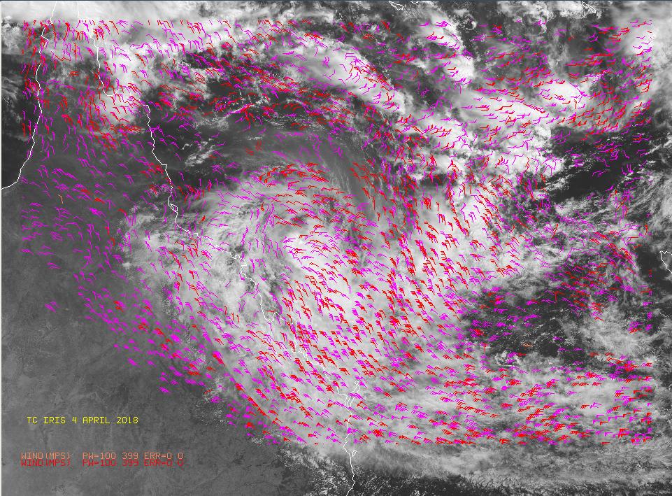
35 Tropical Cyclone Quang Visible image on April 29 at 06:35 UTC (2:35 a.m. EDT) from the MODIS instrument on NASA's Aqua satellite of Tropical Cyclone Quang in the Southern Indian Ocean. Credit: NASA Goddard MODIS
36 TC Quang Himawari-8 AMV Generation Used all Vis/IR image triplets (separated by 10 min/hsf format). (2km ch 14 IR, 1km ch 2 VIS) Employs modified GEOCAT software in initial processing. Height assignment methods similar to GOES-R ABI ATBD AMV estimation is similar to GOES-R ABI ATBD / BoM system Error characterization, selection, QC via EE, QI, ERR etc.
37 TC Quang Himawari-8 AMV Assimilation Used operational TCX system over Timor Sea. Used all Vis/IR image triplets (separated by 10 min/hsf format). (2km IR, 1km VIS) plus full operational data base. TCX is a nested TC model (nested in APS-2 ACCESS-G) of 4km resolution and has 70 levels. Forecast start time 00UTS 29 April 2015
38

39

40 IR Ch 14 and VIS ch 2 image based AMVs 00UT
41 Fig. 14(a) The forecast track of tropical cyclone Quang from 00 UTC 29 April 2015 (red) and the best track (Black), both in six hour intervals

42 Fig. 14(b) Forecast position of tropical cyclone Quang and 6hr accumulated rainfall at 12 UTC 1 May 2015
43 Fig. 15 The original forecast track error of tropical cyclone Quang from 00 UTC 29 April 2015 (yellow) and the final track error (Blue), both in six hour intervals (see text).
44 Summary and Conclusions 10-minute winds are being operationally continuously generated and assimilated in the Australian region with 4D Var H-8 10 minute DMVs have provided an improved spatial and temporal resolution database for analysis and forecasting. The quality of these higher spatial, temporal and spectral density data is of a level which renders them beneficial for NWP. If the data is thinned to equal spatial density, the quality of the H-8 data exceeds that of the operational H7 data. Data assimilation tests showed successful transfer of data into operations and successful use of the data by the NWP system. Further quantification of the impact of these data in our current operational prediction system is underway. This also involves use of all 10 minute data in the prediction of TC activity and severe weather.
45 Future Optimisation of the provision, use and error characterization of AMV data for NWP data at high temporal and spatial resolution. Optimisation of use of the AMV data in NWP in concert with other components of the database (such as clear radiances) at high temporal and spatial resolution. Increasing benefits will continue to accrue from current and next generation advanced instruments, which represent considerable investment by the international community. (eg. CrIS, IASI, VIIRS,EPS-SG,ABI, AHI, MTG, FY-4, GK-2A.). This will need co-investment in staff, infrastructure, research and R2O.

46 Looking Down Is Looking Up TC LAURENCE - Dec. 2009
HIGH SPATIAL AND TEMPORAL RESOLUTION ATMOSPHERIC MOTION VECTORS GENERATION, ERROR CHARACTERIZATION AND ASSIMILATION
 HIGH SPATIAL AND TEMPORAL RESOLUTION ATMOSPHERIC MOTION VECTORS GENERATION, ERROR CHARACTERIZATION AND ASSIMILATION John Le Marshall Director, JCSDA 2004-2007 CAWCR 2007-2010 John Le Marshall 1,2, Rolf
Operational Generation and Assimilation of Himawari-8 Atmospheric Motion Vectors
 Proceedings for the 13 th International Winds Workshop 27 June - 1 July 2016, Monterey, California, USA Operational Generation and Assimilation of Himawari-8 Atmospheric Motion Vectors John Le Marshall
The Contribution of Locally Generated MTSat-1R Atmospheric Motion Vectors to Operational Meteorology in the Australian Region
 The Contribution of Locally Generated MTSat-1R Atmospheric Motion Vectors to Operational Meteorology in the Australian Region John Le Marshall Director, JCSDA 2004-2007 CAWCR 2007-2008 J. Le Marshall,
Observing System Impact Studies in ACCESS
 Observing System Impact Studies in ACCESS www.cawcr.gov.au Chris Tingwell, Peter Steinle, John le Marshall, Elaine Miles, Yi Xiao, Rolf Seecamp, Jin Lee, Susan Rennie, Xingbao Wang, Justin Peter, Alan
JMA s ATMOSPHERIC MOTION VECTORS In response to Action 40.22
 5 July 2013 Prepared by JMA Agenda Item: II/6 Discussed in WG II JMA s ATMOSPHERIC MOTION VECTORS In response to Action 40.22 This paper reports on the recent status of JMA's AMVs from MTSAT-2 and MTSAT-1R,
RECENT ADVANCES IN THE GENERATION AND ASSIMILATION OF HIGH SPATIAL AND TEMPORAL RESOLUTION SATELLITE WINDS
 RECENT ADVANCES IN THE GENERATION AND ASSIMILATION OF HIGH SPATIAL AND TEMPORAL RESOLUTION SATELLITE WINDS J. Le Marshall 1, N. Pescod 1, R. Seecamp 1, A. Rea 2, C. Tingwell 1, G. Ellis 2 and Hao Shi 3
AMVs in the ECMWF system:
 AMVs in the ECMWF system: Overview of the recent operational and research activities Kirsti Salonen and Niels Bormann Slide 1 AMV sample coverage: monitored GOES-15 GOES-13 MET-10 MET-7 MTSAT-2 NOAA-15
HIGH SPATIAL AND TEMPORAL RESOLUTION ATMOSPHERIC MOTION VECTORS GENERATION, ERROR CHARACTERIZATION AND ASSIMILATION
 HIGH SPATIAL AND TEMPORAL RESOLUTION ATMOSPHERIC MOTION VECTORS GENERATION, ERROR CHARACTERIZATION AND ASSIMILATION John Le Marshall 1,2, Rolf Seecamp 3, Yi Xiao 1, J. Jung 4,Terry Skinner 3, Peter Steinle
Assimilation of GOES Hourly and Meteosat winds in the NCEP Global Forecast System (GFS)
") Assimilation of GOES Hourly and Meteosat winds in the NCEP Global Forecast System (GFS) Xiujuan Su, Jaime Daniels, John Derber, Yangrong Lin, Andy Bailey, Wayne Bresky, Hongming Qi JCSDA 11th Workshop
Assimilation of GOES Hourly and Meteosat winds in the NCEP Global Forecast System (GFS) Xiujuan Su, Jaime Daniels, John Derber, Yangrong Lin, Andy Bailey, Wayne Bresky, Hongming Qi JCSDA 11th Workshop
JMA s atmospheric motion vectors
 Prepared by JMA Agenda Item: WG II/6 Discussed in WG II JMA s atmospheric motion vectors This paper reports on the recent status of JMA's Atmospheric Motion Vectors (AMVs) from MTSAT-2 and MTSAT-1R, and
Current status and plans of JMA operational wind product
 Current status and plans of JMA operational wind product Kazuki Shimoji Japan Meteorological Agency / Meteorological Satellite Center 3-235, Nakakiyoto, Kiyose, Tokyo, Japan Abstract The Meteorological
THE ESTIMATION AND UTILITY OF HIGH SPATIAL AND TEMPORAL RESOLUTION WINDS DERIVED FROM GMS-5 OBSERVATIONS
 THE ESTIMATION AND UTILITY OF HIGH SPATIAL AND TEMPORAL RESOLUTION WINDS DERIVED FROM GMS-5 OBSERVATIONS J.F. Le Marshall 1, N.R. Pescod 1 and C. Spinoso 2 Bureau of Meteorology Research Centre GPO Box
Introducing Atmospheric Motion Vectors Derived from the GOES-16 Advanced Baseline Imager (ABI)
") Introducing Atmospheric Motion Vectors Derived from the GOES-16 Advanced Baseline Imager (ABI) Jaime Daniels NOAA/NESDIS, Center for Satellite Applications and Research Wayne Bresky, Andrew Bailey, Americo
Introducing Atmospheric Motion Vectors Derived from the GOES-16 Advanced Baseline Imager (ABI) Jaime Daniels NOAA/NESDIS, Center for Satellite Applications and Research Wayne Bresky, Andrew Bailey, Americo
Assessment of AHI Level-1 Data for HWRF Assimilation
 Assessment of AHI Level-1 Data for HWRF Assimilation Xiaolei Zou 1 and Fuzhong Weng 2 1 Earth System Science Interdisciplinary Center, University of Maryland, College Park, Maryland 2 Satellite Meteorology
AMVs in the operational ECMWF system
 AMVs in the operational ECMWF system Kirsti Salonen and Niels Bormann Slide 1 AMV sample coverage: monitored GOES-15 GOES-13 MET-10 MET-7 MTSAT-2 NOAA-15 NOAA-18 NOAA-19 FY-2D FY-2E AQUA TERRA METOP-A
Ninth Workshop on Meteorological Operational Systems. Timeliness and Impact of Observations in the CMC Global NWP system
 Ninth Workshop on Meteorological Operational Systems ECMWF, Reading, United Kingdom 10 14 November 2003 Timeliness and Impact of Observations in the CMC Global NWP system Réal Sarrazin, Yulia Zaitseva
Current Status of COMS AMV in NMSC/KMA
 Current Status of COMS AMV in NMSC/KMA Eunha Sohn, Sung-Rae Chung, Jong-Seo Park Satellite Analysis Division, NMSC/KMA soneh0431@korea.kr COMS AMV of KMA/NMSC has been produced hourly since April 1, 2011.
The Use of Hyperspectral Infrared Radiances In Numerical Weather Prediction
 The Use of Hyperspectral Infrared Radiances In Numerical Weather Prediction J. Le Marshall 1, J. Jung 1, J. Derber 1, T. Zapotocny 2, W. L. Smith 3, D. Zhou 4, R. Treadon 1, S. Lord 1, M. Goldberg 1 and
GENERATION OF HIMAWARI-8 AMVs USING THE FUTURE MTG AMV PROCESSOR
 GENERATION OF HIMAWARI-8 AMVs USING THE FUTURE MTG AMV PROCESSOR Manuel Carranza 1, Régis Borde 2, Masahiro Hayashi 3 1 GMV Aerospace and Defence S.A. at EUMETSAT, Eumetsat Allee 1, D-64295 Darmstadt,
OSSE to infer the impact of Arctic AMVs extracted from highly elliptical orbit imagery
 OSSE to infer the impact of Arctic AMVs extracted from highly elliptical orbit imagery L. Garand 1 Y. Rochon 1, S. Heilliette 1, J. Feng 1, A.P. Trishchenko 2 1 Environment Canada, 2 Canada Center for
TOWARDS IMPROVED HEIGHT ASSIGNMENT AND QUALITY CONTROL OF AMVS IN MET OFFICE NWP
 Proceedings for the 13 th International Winds Workshop 27 June - 1 July 2016, Monterey, California, USA TOWARDS IMPROVED HEIGHT ASSIGNMENT AND QUALITY CONTROL OF AMVS IN MET OFFICE NWP James Cotton, Mary
The satellite winds in the operational NWP system at Météo-France
 The satellite winds in the operational NWP system at Météo-France Christophe Payan CNRM UMR 3589, Météo-France/CNRS 13th International Winds Workshop, Monterey, USA, 27 June 1st July 2016 Outline Operational
Assimilation of Himawari-8 Atmospheric Motion Vectors into the Numerical Weather Prediction Systems of Japan Meteorological Agency
 Assimilation of Himawari-8 Atmospheric Motion Vectors into the Numerical Weather Prediction Systems of Japan Meteorological Agency Koji Yamashita Japan Meteorological Agency kobo.yamashita@met.kishou.go.jp,
IMPACT STUDIES OF AMVS AND SCATTEROMETER WINDS IN JMA GLOBAL OPERATIONAL NWP SYSTEM
 IMPACT STUDIES OF AMVS AND SCATTEROMETER WINDS IN JMA GLOBAL OPERATIONAL NWP SYSTEM Koji Yamashita Japan Meteorological Agency / Numerical Prediction Division 1-3-4, Otemachi, Chiyoda-ku, Tokyo 100-8122,
STATUS OF JAPANESE METEOROLOGICAL SATELLITES AND RECENT ACTIVITIES OF MSC
 STATUS OF JAPANESE METEOROLOGICAL SATELLITES AND RECENT ACTIVITIES OF MSC Daisaku Uesawa Meteorological Satellite Center, Japan Meteorological Agency Abstract MTSAT-1R is the current operational Japanese
NUMERICAL EXPERIMENTS USING CLOUD MOTION WINDS AT ECMWF GRAEME KELLY. ECMWF, Shinfield Park, Reading ABSTRACT
 NUMERICAL EXPERIMENTS USING CLOUD MOTION WINDS AT ECMWF GRAEME KELLY ECMWF, Shinfield Park, Reading ABSTRACT Recent monitoring of cloud motion winds (SATOBs) at ECMWF has shown an improvement in quality.
Recent Advances in the Processing, Targeting and Data Assimilation Applications of Satellite-Derived Atmospheric Motion Vectors (AMVs)
") Recent Advances in the Processing, Targeting and Data Assimilation Applications of Satellite-Derived Atmospheric Motion Vectors (AMVs) Howard Berger and Chris Velden Cooperative Institute for Meteorological
Recent Advances in the Processing, Targeting and Data Assimilation Applications of Satellite-Derived Atmospheric Motion Vectors (AMVs) Howard Berger and Chris Velden Cooperative Institute for Meteorological
Jun Mitch Goldberg %, Pei Timothy J. Schmit &, Jinlong Zhenglong and Agnes
 Progress on the assimilation of advanced IR sounder radiances in cloudy skies Jun Li @, Mitch Goldberg %, Pei Wang @#, Timothy J. Schmit &, Jinlong Li @, Zhenglong Li @, and Agnes Lim @ @CIMSS, University
The Impact of Satellite Atmospheric Motion Vectors in the U.S. Navy Global Data Assimilation System NWP Results
 The Impact of Satellite Atmospheric Motion Vectors in the U.S. Navy Global Data Assimilation System NWP Results Nancy L. Baker 1, Rolf Langland 1, Patricia M. Pauley 1, Liang Xu 1, Dagmar Merkova 2,3,
Assimilation of Himawari-8 data into JMA s NWP systems
 Assimilation of Himawari-8 data into JMA s NWP systems Masahiro Kazumori, Koji Yamashita and Yuki Honda Numerical Prediction Division, Japan Meteorological Agency 1. Introduction The new-generation Himawari-8
The role of GPS-RO at ECMWF" ! COSMIC Data Users Workshop!! 30 September 2014! !!! ECMWF
 The role of GPS-RO at ECMWF"!!!! COSMIC Data Users Workshop!! 30 September 2014! ECMWF WE ARE Intergovernmental organisation! 34 Member and Cooperating European states! 270 staff at ECMWF, in Reading,
AN OBSERVING SYSTEM EXPERIMENT OF MTSAT RAPID SCAN AMV USING JMA MESO-SCALE OPERATIONAL NWP SYSTEM
 AN OBSERVING SYSTEM EXPERIMENT OF MTSAT RAPID SCAN AMV USING JMA MESO-SCALE OPERATIONAL NWP SYSTEM Koji Yamashita Japan Meteorological Agency / Numerical Prediction Division 1-3-4, Otemachi, Chiyoda-ku,
Impact of assimilating the VIIRS-based CrIS cloudcleared radiances on hurricane forecasts
 Impact of assimilating the VIIRS-based CrIS cloudcleared radiances on hurricane forecasts Jun Li @, Pei Wang @, Jinlong Li @, Zhenglong Li @, Jung-Rim Lee &, Agnes Lim @, Timothy J. Schmit #, and Mitch
Advances in weather modelling
 Advances in weather modelling www.cawcr.gov.au Robert Fawcett - speaking on behalf of CAWCR Earth-System Modelling and CAWCR Weather and Environmental Prediction May 2013 The Centre for Australian Weather
Marine Meteorology Division, Naval Research Laboratory, Monterey, CA. Tellus Applied Sciences, Inc.
 Nancy Baker 1, Rolf Langland 1, Pat Pauley 1, Liang Xu 1 Dagmar Merkova 2,3 and Ron Gelaro 2 Chris Velden 4 1 Marine Meteorology Division, Naval Research Laboratory, Monterey, CA 2 Global Modeling and
RETRIEVAL AND APPLICATIONS OF ATMOSPHERIC MOTION VECTORS USING INSAT-3D/3DR DATA : ISRO STATUS
 RETRIEVAL AND APPLICATIONS OF ATMOSPHERIC MOTION VECTORS USING INSAT-3D/3DR DATA : ISRO STATUS Sanjib K Deb, D K Sankhala, C M Kishtawal Atmospheric and Oceanic Sciences Group Space Applications Centre
Analysis of an Observing System Experiment for the Joint Polar Satellite System
 Analysis of an Observing System Experiment for the Joint Polar Satellite System S. Lord, George Gayno 1 and Fanglin Yang 1 24 November 2015 1 I. M. Systems Group at NCEP/EMC 1 Outline The Joint Polar Satellite
OBSERVING SYSTEM EXPERIMENTS ON ATOVS ORBIT CONSTELLATIONS
 OBSERVING SYSTEM EXPERIMENTS ON ATOVS ORBIT CONSTELLATIONS Enza Di Tomaso and Niels Bormann European Centre for Medium-range Weather Forecasts Shinfield Park, Reading, RG2 9AX, United Kingdom Abstract
Upgraded usage of MODIS-derived polar winds in the JMA operational global 4D-Var assimilation system
 1 Upgraded usage of MODIS-derived polar winds in the JMA operational global 4D-Var assimilation system Koji Yamashita Japan Meteorological Agency Kobo.yamashita@met.kishou.go.jp Background Objectives 2
Masahiro Kazumori, Takashi Kadowaki Numerical Prediction Division Japan Meteorological Agency
 Development of an all-sky assimilation of microwave imager and sounder radiances for the Japan Meteorological Agency global numerical weather prediction system Masahiro Kazumori, Takashi Kadowaki Numerical
Observing system experiments of MTSAT-2 Rapid Scan Atmospheric Motion Vector for T-PARC 2008 using the JMA operational NWP system
 Tenth International Winds Workshop 1 Observing system experiments of MTSAT-2 Rapid Scan Atmospheric Motion Vector for T-PARC 2008 using the JMA operational NWP system Koji Yamashita Japan Meteorological
On the assimilation of hyperspectral infrared sounder radiances in cloudy skies
 On the assimilation of hyperspectral infrared sounder radiances in cloudy skies Jun Li 1, Pei Wang 1, Zhenglong Li 1, Jinlong Li 1 and Mitchell D. Goldberg 2 1 Cooperative Institute for Meteorological
Preparation for Himawari 8
 Preparation for Himawari 8 Japan Meteorological Agency Meteorological Satellite Center Hidehiko MURATA ET SUP 8, WMO HQ, Geneva, 14 17 April 2014 1/18 Introduction Background The Japan Meteorological Agency
SATELLITE DATA IMPACT STUDIES AT ECMWF
 SATELLITE DATA IMPACT STUDIES AT ECMWF Outline of talk 1. Impact of early sounders (past and in reanalysis) 2. Problems with satellite retrievals 3. Direct use of radiances 4. Impact experiments with ERA
Improving Tropical Cyclone Forecasts by Assimilating Microwave Sounder Cloud-Screened Radiances and GPM precipitation measurements
 Improving Tropical Cyclone Forecasts by Assimilating Microwave Sounder Cloud-Screened Radiances and GPM precipitation measurements Hyojin Han a, Jun Li a, Mitch Goldberg b, Pei Wang a,c, Jinlong Li a,
AMVs in the ECMWF system:
 AMVs in the ECMWF system: Highlights of the operational and research activities Kirsti Salonen and Niels Bormann Slide 1 Number of used AMVs Look back: how the use of AMVs has evolved NOAA-15,-16,-18,-19
Use of satellite winds at Deutscher Wetterdienst (DWD)
") Use of satellite winds at Deutscher Wetterdienst (DWD) Alexander Cress Deutscher Wetterdienst, Frankfurter Strasse 135, 63067 Offenbach am Main, Germany alexander.cress@dwd.de Ø Introduction Ø Atmospheric
Use of satellite winds at Deutscher Wetterdienst (DWD) Alexander Cress Deutscher Wetterdienst, Frankfurter Strasse 135, 63067 Offenbach am Main, Germany alexander.cress@dwd.de Ø Introduction Ø Atmospheric
Operational Use of Scatterometer Winds at JMA
 Operational Use of Scatterometer Winds at JMA Masaya Takahashi Numerical Prediction Division, Japan Meteorological Agency (JMA) 10 th International Winds Workshop, Tokyo, 26 February 2010 JMA Outline JMA
GOES-16 AMV data evaluation and algorithm assessment
 GOES-16 AMV data evaluation and algorithm assessment Katie Lean and Niels Bormann IWW14, Jeju Island, South Korea, 23-27 th April 2018 katie.lean@ecmwf.int ECMWF May 3, 2018 Outline Introduction Changes
NESDIS Atmospheric Motion Vector (AMV) Nested Tracking Algorithm: Exploring its Performance
 Nested Tracking Algorithm: Exploring its Performance") NESDIS Atmospheric Motion Vector (AMV) Nested Tracking Algorithm: Exploring its Performance Jaime Daniels NOAA/NESDIS, Center for Satellite Applications and Research Wayne Bresky & Andrew Bailey IM Systems
NESDIS Atmospheric Motion Vector (AMV) Nested Tracking Algorithm: Exploring its Performance Jaime Daniels NOAA/NESDIS, Center for Satellite Applications and Research Wayne Bresky & Andrew Bailey IM Systems
Impact of METOP ASCAT Ocean Surface Winds in the NCEP GDAS/GFS and NRL NAVDAS
 Impact of METOP ASCAT Ocean Surface Winds in the NCEP GDAS/GFS and NRL NAVDAS COAMPS @ Li Bi 1,2 James Jung 3,4 Michael Morgan 5 John F. Le Marshall 6 Nancy Baker 2 Dave Santek 3 1 University Corporation
ACCOUNTING FOR THE SITUATION-DEPENDENCE OF THE AMV OBSERVATION ERROR IN THE ECMWF SYSTEM
 ACCOUNTING FOR THE SITUATION-DEPENDENCE OF THE AMV OBSERVATION ERROR IN THE ECMWF SYSTEM Kirsti Salonen and Niels Bormann ECMWF, Shinfield Park, Reading RG2 9AX, United Kingdom Abstract This article reports
Satellite-Derived Winds in the U.S. Navy s Global NWP System: Usage and Data Impacts in the Tropics
 Satellite-Derived Winds in the U.S. Navy s Global NWP System: Usage and Data Impacts in the Tropics Patricia Pauley 1, Rolf Langland 1, Rebecca Stone 2, and Nancy Baker 1 1 Naval Research Laboratory, Monterey,
CURRENT STATUS OF OPERATIONAL WIND PRODUCT IN JMA/MSC
 Proceedings for the 13 th International Winds Workshop 27 June - 1 July 2016, Monterey, California, USA CURRENT STATUS OF OPERATIONAL WIND PRODUCT IN JMA/MSC Kazuki Shimoji and Kenichi Nonaka JMA/MSC,
Data Impact Studies in the CMC Global NWP system
 Third WMO Workshop on the Impact of Various Observing Systems on WP Alpbach, Austria 9 12 March 2004 Data Impact Studies in the CMC Global WP system Gilles Verner, Réal Sarrazin and Yulia Zaitseva Canadian
Assessment of new AMV data in the ECMWF system: First year report
 EUMETSAT/ECMWF Fellowship Programme Research Report No. 43 Assessment of new AMV data in the ECMWF system: First year report K. Lean, N. Bormann and K. Salonen January 2017 Series: EUMETSAT/ECMWF Fellowship
Assimilation of IASI data at the Met Office. Fiona Hilton Nigel Atkinson ITSC-XVI, Angra dos Reis, Brazil 07/05/08
 Assimilation of IASI data at the Met Office Fiona Hilton Nigel Atkinson ITSC-XVI, Angra dos Reis, Brazil 07/05/08 Thanks to my other colleagues! Andrew Collard (ECMWF) Brett Candy, Steve English, James
Use of DFS to estimate observation impact in NWP. Comparison of observation impact derived from OSEs and DFS. Cristina Lupu
 Use of DFS to estimate observation impact in NWP. Comparison of observation impact derived from OSEs and DFS. Cristina Lupu ECMWF, Reading, UK Collaboration: Pierre Gauthier (UQAM), Stéphane Laroche (Environment
VALIDATION OF DUAL-MODE METOP AMVS
 VALIDATION OF DUAL-MODE METOP AMVS Ákos Horváth 1, Régis Borde 2, and Hartwig Deneke 1 1 Leibniz Institute for Tropospheric Research, Permoserstrasse 15, Leipzig, Germany 2 EUMETSAT, Eumetsat Allee 1,
ASSIMILATION OF CLOUDY AMSU-A MICROWAVE RADIANCES IN 4D-VAR 1. Stephen English, Una O Keeffe and Martin Sharpe
 ASSIMILATION OF CLOUDY AMSU-A MICROWAVE RADIANCES IN 4D-VAR 1 Stephen English, Una O Keeffe and Martin Sharpe Met Office, FitzRoy Road, Exeter, EX1 3PB Abstract The assimilation of cloud-affected satellite
Feature-tracked 3D Winds from Satellite Sounders: Derivation and Impact in Global Models
 Feature-tracked 3D Winds from Satellite Sounders: Derivation and Impact in Global Models David Santek 1, A.-S. Daloz 1, S. Tushaus 1, M. Rogal 1, W. McCarty 2 1 Space Science and Engineering Center/University
Satellite Radiance Data Assimilation at the Met Office
 Satellite Radiance Data Assimilation at the Met Office Ed Pavelin, Stephen English, Brett Candy, Fiona Hilton Outline Summary of satellite data used in the Met Office NWP system Processing and quality
ASSIMILATION EXPERIMENTS WITH DATA FROM THREE CONICALLY SCANNING MICROWAVE INSTRUMENTS (SSMIS, AMSR-E, TMI) IN THE ECMWF SYSTEM
 IN THE ECMWF SYSTEM") ASSIMILATION EXPERIMENTS WITH DATA FROM THREE CONICALLY SCANNING MICROWAVE INSTRUMENTS (SSMIS, AMSR-E, TMI) IN THE ECMWF SYSTEM Niels Bormann 1, Graeme Kelly 1, Peter Bauer 1, and Bill Bell 2 1 ECMWF,
ASSIMILATION EXPERIMENTS WITH DATA FROM THREE CONICALLY SCANNING MICROWAVE INSTRUMENTS (SSMIS, AMSR-E, TMI) IN THE ECMWF SYSTEM Niels Bormann 1, Graeme Kelly 1, Peter Bauer 1, and Bill Bell 2 1 ECMWF,
STATUS AND DEVELOPMENT OF SATELLITE WIND MONITORING BY THE NWP SAF
 STATUS AND DEVELOPMENT OF SATELLITE WIND MONITORING BY THE NWP SAF Mary Forsythe (1), Antonio Garcia-Mendez (2), Howard Berger (1,3), Bryan Conway (4), Sarah Watkin (1) (1) Met Office, Fitzroy Road, Exeter,
PCA assimilation techniques applied to MTG-IRS
 PCA assimilation techniques applied to MTG-IRS Marco Matricardi ECMWF Shinfield Park, Reading, UK WORKSHOP Assimilation of Hyper-spectral Geostationary Satellite Observation ECMWF Reading UK 22-25 May
Satellite Assimilation Activities for the NRL Atmospheric Variational Data Assimilation (NAVDAS) and NAVDAS- AR (Accelerated Representer) Systems
 and NAVDAS- AR (Accelerated Representer) Systems") Satellite Assimilation Activities for the NRL Atmospheric Variational Data Assimilation (NAVDAS) and NAVDAS- AR (Accelerated Representer) Systems Marine Meteorology Division, NRL Monterey Nancy Baker,
Satellite Assimilation Activities for the NRL Atmospheric Variational Data Assimilation (NAVDAS) and NAVDAS- AR (Accelerated Representer) Systems Marine Meteorology Division, NRL Monterey Nancy Baker,
IMPACT STUDIES OF HIGHER RESOLUTION COMS AMV IN THE KMA NWP SYSTEM
 Proceedings for the 13 th International Winds Workshop 27 June - 1 July 2016, Monterey, California, USA IMPACT STUDIES OF HIGHER RESOLUTION COMS AMV IN THE KMA NWP SYSTEM Jung-Rim Lee, Hyun-Cheol Shin,
The satellite winds in the operational NWP system at Météo-France
 The satellite winds in the operational NWP system at Météo-France Christophe Payan CNRM UMR3589, Météo-France/CNRS, 42 avenue Gaspard Coriolis, Toulouse, France Abstract A major upgrade of the global model
Improved Use of AIRS Data at ECMWF
 Improved Use of AIRS Data at ECMWF A.D. Collard, A.P. McNally European Centre for Medium-Range Weather Forecasts, Reading, U.K. W.W. Wolf QSS Group, Inc., NOAA Science Center, 5200 Auth Road, Camp Springs
AOMSUC-6 Training Event
 Effective use of high temporal and spatial resolution Himawari-8 data AOMSUC-6 Training Event Bodo Zeschke Australian Bureau of Meteorology Training Centre Australian VLab Centre of Excellence Content
Improving the use of satellite winds at the Deutscher Wetterdienst (DWD)
") Improving the use of satellite winds at the Deutscher Wetterdienst (DWD) Alexander Cress Deutscher Wetterdienst, Frankfurter Strasse 135, 63067 Offenbach am Main, Germany alexander.cress@dwd.de Ø Introduction
Improving the use of satellite winds at the Deutscher Wetterdienst (DWD) Alexander Cress Deutscher Wetterdienst, Frankfurter Strasse 135, 63067 Offenbach am Main, Germany alexander.cress@dwd.de Ø Introduction
ESTIMATION OF THE SEA SURFACE WIND IN THE VICINITY OF TYPHOON USING HIMAWARI-8 LOW-LEVEL AMVS
 Proceedings for the 13 th International Winds Workshop 27 June - 1 July 2016, Monterey, California, USA ESTIMATION OF THE SEA SURFACE WIND IN THE VICINITY OF TYPHOON USING HIMAWARI-8 LOW-LEVEL AMVS Kenichi
Feature-tracked 3D Winds from Satellite Sounders: Derivation and Impact in Global Models
 Feature-tracked 3D Winds from Satellite Sounders: Derivation and Impact in Global Models David Santek, Anne-Sophie Daloz 1, Samantha Tushaus 1, Marek Rogal 1, Will McCarty 2 1 Space Science and Engineering
The Nowcasting Demonstration Project for London 2012
 The Nowcasting Demonstration Project for London 2012 Susan Ballard, Zhihong Li, David Simonin, Jean-Francois Caron, Brian Golding, Met Office, UK Introduction The success of convective-scale NWP is largely
Recent Data Assimilation Activities at Environment Canada
 Recent Data Assimilation Activities at Environment Canada Major upgrade to global and regional deterministic prediction systems (now in parallel run) Sea ice data assimilation Mark Buehner Data Assimilation
Applications of future GEO advanced IR sounder for high impact weather forecasting demonstration with regional OSSE
 Applications of future GEO advanced IR sounder for high impact weather forecasting demonstration with regional OSSE Jun Li @, Tim Schmit &, Zhenglong Li @, Feng Zhu @*, Pei Wang @*, Agnes Lim @, and Robert
Maryland 20746, U.S.A. Engineering Center (SSEC), University of Wisconsin Madison, Wisconsin 53706, U.S.A ABSTRACT
, University of Wisconsin Madison, Wisconsin 53706, U.S.A ABSTRACT") NESDIS Atmospheric Motion Vector (AMV) Nested Tracking Algorithm: Exploring its Performance Jaime Daniels 1, Wayne Bresky 2, Steven Wanzong 3, Andrew Bailey 2, and Chris Velden 3 1 NOAA/NESDIS Office of
NESDIS Atmospheric Motion Vector (AMV) Nested Tracking Algorithm: Exploring its Performance Jaime Daniels 1, Wayne Bresky 2, Steven Wanzong 3, Andrew Bailey 2, and Chris Velden 3 1 NOAA/NESDIS Office of
RECENT UPGRADES OF AND ACTIVITIES FOR ATMOSPHERIC MOTION VECTORS AT JMA/MSC
 1 th International Winds Workshop, Tokyo, Japan, - ruary 1 RECENT UPGRADES OF AND ACTIVITIES FOR ATMOSPHERIC MOTION VECTORS AT JMA/MSC Ryo OYAMA Meteorological Satellite Center of Japan Meteorological
FUTURE PLAN AND RECENT ACTIVITIES FOR THE JAPANESE FOLLOW-ON GEOSTATIONARY METEOROLOGICAL SATELLITE HIMAWARI-8/9
 FUTURE PLAN AND RECENT ACTIVITIES FOR THE JAPANESE FOLLOW-ON GEOSTATIONARY METEOROLOGICAL SATELLITE HIMAWARI-8/9 Toshiyuki Kurino Japan Meteorological Agency, 1-3-4 Otemachi Chiyodaku, Tokyo 100-8122,
Assessment of Himawari-8 AMV data in the ECMWF system
 EUMETSAT/ECMWF Fellowship Programme Research Report No. 42 Assessment of Himawari-8 AMV data in the ECMWF system K. Lean, N. Bormann and K. Salonen December 2016 Series: EUMETSAT/ECMWF Fellowship Programme
Quarterly numerical weather prediction model performance summaries April to June 2010 and July to September 2010
 Australian Meteorological and Oceanographic Journal 60 (2010) 301-305 Quarterly numerical weather prediction model performance summaries April to June 2010 and July to September 2010 Xiaoxi Wu and Chris
Impact Evaluation of New Radiance data, Reduced Thinning and Higher Analysis Resolution in the GEM Global Deterministic Prediction System
 Impact Evaluation of New Radiance data, Reduced Thinning and Higher Analysis Resolution in the GEM Global Deterministic Prediction ITSC-17, Monterey, California Presenter: G. Deblonde*1, Co-authors: A.
A two-season impact study of the Navy s WindSat surface wind retrievals in the NCEP global data assimilation system
 A two-season impact study of the Navy s WindSat surface wind retrievals in the NCEP global data assimilation system Li Bi James Jung John Le Marshall 16 April 2008 Outline WindSat overview and working
Recent experience at Météo-France on the assimilation of observations at high temporal frequency Cliquez pour modifier le style du titre
 Recent experience at Météo-France on the assimilation of observations at high temporal frequency Cliquez pour modifier le style du titre J.-F. Mahfouf, P. Brousseau, P. Chambon and G. Desroziers Météo-France/CNRS
Impact of hyperspectral IR radiances on wind analyses
 Impact of hyperspectral IR radiances on wind analyses Kirsti Salonen and Anthony McNally Kirsti.Salonen@ecmwf.int ECMWF November 30, 2017 Motivation The upcoming hyper-spectral IR instruments on geostationary
Bias correction of satellite data at the Met Office
 Bias correction of satellite data at the Met Office Nigel Atkinson, James Cameron, Brett Candy and Steve English ECMWF/EUMETSAT NWP-SAF Workshop on Bias estimation and correction in data assimilation,
The assimilation of AMSU and SSM/I brightness temperatures in clear skies at the Meteorological Service of Canada
 The assimilation of AMSU and SSM/I brightness temperatures in clear skies at the Meteorological Service of Canada Abstract David Anselmo and Godelieve Deblonde Meteorological Service of Canada, Dorval,
Using Clear and Cloudy AIRS Data in Numerical Weather Prediction
 Using Clear and Cloudy AIRS Data in Numerical Weather Prediction J. Le Marshall (, 2), J. Jung (,3), M. Goldberg (4), L-P Riishojgaard, C. Barnet (4), W. Wolf (4), J. Derber (5,), R. Treadon (5,) and S.
THE BENEFITS OF INCREASED USE OF THE INFORMATION CONTENT OF HYPERSPECTRAL
 THE BENEFITS OF INCREASED USE OF THE INFORMATION CONTENT OF HYPERSPECTRAL J4.4 OBSERVATIONS IN NUMERICAL WEATHER PREDICTION J. Le Marshall (, 2 ) * and J. Jung (3,4) Centre for Australian Weather and Climate
Numerical Weather prediction at the European Centre for Medium-Range Weather Forecasts
 Numerical Weather prediction at the European Centre for Medium-Range Weather Forecasts Time series curves 500hPa geopotential Correlation coefficent of forecast anomaly N Hemisphere Lat 20.0 to 90.0 Lon
MODIS- and AVHRR-derived Polar Winds Experiments using the NCEP GDAS/GFS NA10NES
 Proposed Work MODIS- and AVHRR-derived Polar Winds Experiments using the NCEP GDAS/GFS NA10NES4400011 Year 3 First-half Progress Report June 2012 through November 2012 28 December 2012 David Santek, PI
Effect of Predictor Choice on the AIRS Bias Correction at the Met Office
 Effect of Predictor Choice on the AIRS Bias Correction at the Met Office Brett Harris Bureau of Meterorology Research Centre, Melbourne, Australia James Cameron, Andrew Collard and Roger Saunders, Met
NWP SAF AMV monitoring: the 7th Analysis Report (AR7)
") Document NWPSAF-MO-TR-032 Version 1.0 24/05/16 NWP SAF AMV monitoring: the 7th Analysis Report (AR7) Francis Warrick Met Office, UK NWP SAF AMV monitoring: the 7th Analysis Report (AR7) Francis Warrick
Document NWPSAF-MO-TR-032 Version 1.0 24/05/16 NWP SAF AMV monitoring: the 7th Analysis Report (AR7) Francis Warrick Met Office, UK NWP SAF AMV monitoring: the 7th Analysis Report (AR7) Francis Warrick
Shorter contribution
 Aust. Met. Mag. 57 (2008) 249-254 Shorter contribution Using cloudy AIRS fields of view in numerical weather prediction J. Le Marshall 1, 2, J. Jung 2, 3, M. Goldberg 4, C. Barnet 4, W. Wolf 4, J. Derber
ALGORITHM AND SOFTWARE DEVELOPMENT OF ATMOSPHERIC MOTION VECTOR (AMV) PRODUCTS FOR THE FUTURE GOES-R ADVANCED BASELINE IMAGER (ABI)
 PRODUCTS FOR THE FUTURE GOES-R ADVANCED BASELINE IMAGER (ABI)") ALGORITHM AND SOFTWARE DEVELOPMENT OF ATMOSPHERIC MOTION VECTOR (AMV) PRODUCTS FOR THE FUTURE GOES-R ADVANCED BASELINE IMAGER (ABI) Jaime Daniels 1, Chris Velden 2, Wayne Bresky 3, Iliana Genkova 2, and
ALGORITHM AND SOFTWARE DEVELOPMENT OF ATMOSPHERIC MOTION VECTOR (AMV) PRODUCTS FOR THE FUTURE GOES-R ADVANCED BASELINE IMAGER (ABI) Jaime Daniels 1, Chris Velden 2, Wayne Bresky 3, Iliana Genkova 2, and
IMPACT OF IASI DATA ON FORECASTING POLAR LOWS
 IMPACT OF IASI DATA ON FORECASTING POLAR LOWS Roger Randriamampianina rwegian Meteorological Institute, Pb. 43 Blindern, N-0313 Oslo, rway rogerr@met.no Abstract The rwegian THORPEX-IPY aims to significantly
Wind tracing from SEVIRI clear and overcast radiance assimilation
 Wind tracing from SEVIRI clear and overcast radiance assimilation Cristina Lupu and Tony McNally ECMWF, Reading, UK Slide 1 Outline Motivation & Objective Analysis impact of SEVIRI radiances and cloudy
AMVS: PAST PROGRESS, FUTURE CHALLENGES
 Proceedings for the 13 th International Winds Workshop 27 June - 1 July 2016, Monterey, California, USA AMVS: PAST PROGRESS, FUTURE CHALLENGES Mary Forsythe, James Cotton, Francis Warrick Met Office, FitzRoy
Benefits of the new-generation Himawari-8 geostationary satellite for the Asia-Pacific region. Toshihiko HASHIDA Japan Meteorological Agency (JMA)
") Benefits of the new-generation Himawari-8 geostationary satellite for the Asia-Pacific region Toshihiko HASHIDA Japan Meteorological Agency (JMA) Side Event Ensuring User Readiness to New-Generation Meteorological
Benefits of the new-generation Himawari-8 geostationary satellite for the Asia-Pacific region Toshihiko HASHIDA Japan Meteorological Agency (JMA) Side Event Ensuring User Readiness to New-Generation Meteorological
Application of Himawari-8 AHI Data to the GOES-R Rainfall Rate Algorithm
 Application of Himawari-8 AHI Data to the GOES-R Rainfall Rate Algorithm Yaping Li 1, Robert Kuligowski 2 and Yan Hao 1 1. IMSG at NOAA/NESDIS/STAR 2. NOAA/NESDIS/STAR, College Park, MD 1 GOES-R Baseline