The Nowcasting Demonstration Project for London 2012
|
|
|
- Piers Hensley
- 5 years ago
- Views:
Transcription


1 The Nowcasting Demonstration Project for London 2012 Susan Ballard, Zhihong Li, David Simonin, Jean-Francois Caron, Brian Golding, Met Office, UK
2 Introduction The success of convective-scale NWP is largely in dynamical downscaling of accurate large-scale forecasts using high resolution topography - particularly in the UK, where progressive weather systems & proximity to the coast mean there is little memory of one day s convection to the next Prediction of severe weather impacts requires high precision & accuracy in the first few hours - when convective-scale forecasting is truly an initial value problem Recent data assimilation advances using hybrids of 4D-Var & EnKF show great promise - but convective-scale is very different from synoptic scale In March 2012 the Met Office implemented an hourly 4D-Var assimilation cycle with 12-hour forecasts in the Nowcasting Demonstration Project (NDP)
 3 hr 3 hr T+36 (every 6h) NDP (Southern UK) 1.5 km 4D-Var (3km) 1 hr 1 hr T+12h Nested in UKV.")
3 Configuration of the NDP Model Resolution DA method DA time window Cycling Forecast Length UKV (UK) 1.5km 3D-Var (3km) 3 hr 3 hr T+36 (every 6h) NDP (Southern UK) 1.5 km 4D-Var (3km) 1 hr 1 hr T+12h Nested in UKV. LBCs updated every 30mins; refreshed every 3 hours
4 Use of Observations in NDP 4D-Var assimilation of sub-hourly observations: Doppler radial winds from 5 radars, every 10 mins winds from 4 wind profilers every 15 mins MSG SEVIRI satellite radiances: channel 5, channel 6 & window channels (sea only) every 15 mins hourly 3D moisture from satellite + surface cloud obs hourly MSG cloud- and humidity-tracked winds hourly aircraft temperature & wind hourly surface temperature, relative humidity, wind & pressure Latent Head Nudging of radar-derived surface rain rates every 15 minutes
5 12hour fcst from T-30mins Takes ~10mins Available T+60mins NDP CYCLE 1 hour fcst from T-90mins for background (first guess) 1hour to 2hour fcst from T-90mins with output every 10mins for T-30mins to T+30mins for Simulating observations In 4D-VAR T-30mins Observations 4D-Var Observation window Current analysis Observation cut off T+45mins Observation Processing~1-2mins 3D-Var ~ 1-2mins 4D-Var ~ 3-10mins takes longer time if raining as more Doppler radial wind data T+30mins T-60mins T+0 T+60mins Previous analysis time Latent Heat Nudging Next analysis time Radar-derived rain rates (every 15 mins) Nudging

6 Spreading observations in space: assimilating a 2K temperature increment with 1K error at 850hPa UKV length scales derived from 24 & 12 hour forecast differences at radiosonde locations: 180 km for streamfunction, 130 km for velocity potential / unbalanced pressure & 90 km for humidity NDP length scales derived directly from 6 & 3 hour forecast differences and vary with vertical mode: km for velocity potential / stream function & between 30 km - 2 km for unbalanced pressure / humidity
7 Benefits of assimilating Doppler winds: 3D-Var & 4D-Var Trial of hourly Doppler winds in 3D-Var in 4 cases of ~17 cycles Fraction Skill Score for hourly rain accumulations >0.2 mm at 55km scale Trial comparing hourly 3D- Var & sub-hourly 4D-Var on 2 cases of 16 and 23 cycles RMSE in m/s of the forecasts compared to the Doppler wind observations as a function of lead time Doppler radial winds introduced operationally in UKV model, every 3 hours, from July DVAR With Doppler No Doppler 4DVAR


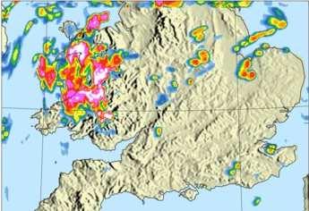
8 Oxfordshire tornado, 7th May 2012: comparison of analyses for 15UTC 15UTC NDP T+0 15UTC UKV T+0 15UTC radar composite


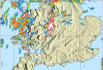
9 Oxfordshire tornado, 7th May 2012: NDP forecasts for 15UTC T+0 T+1 T+2 All NDP forecasts from 12UTC onwards had a good forecast of the location of the storms at 15UTC - skill improves with time
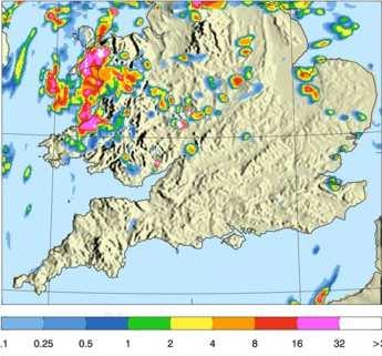
10 Line Convection: 1500UTC 28 th May 2012 Sferics obs NDP T+5 radar Thunderstorms not present at analysis times STEPS failed to predict storms: neither extrapolation nor UK4 had them UKV developed isolated storms too far east NDP has a good representation of the thunderstorms STEPS T+5 UKV T+12
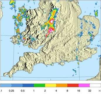
11 Thunderstorms & flooding June 28 th 2012: NDP forecasts for 09UTC NDP T+3 NDP T+1 NDP T+2 radar


12 Thunderstorms & flooding June 28 th 2012: NDP forecasts for 12UTC NDP T+4 NDP T+1 NDP T+2 radar

13 Flash Flooding, July 12 th 2012, 13UTC UKV T+10 UKV T+4 UKV T+10 is best match to reality Later UKV & NDP appear to break up the rain band radar NDP T+4 NDP T+1
14 Summary A high resolution (1.5km) NWP nowcasting system is run over the southern UK for evaluation during London 2012 The system produces a 12 hour forecast every hour by 30mins after the end of the observation window It assimilates sub-hourly Doppler winds, wind profiler, GPS & MSG SEVIRI data using hourly cycling 4D-Var Results are sometimes significantly better than the 6- hourly UKV, but substantial challenges remain Results are compared with STEPS and will ultimately replace it A UK-wide successor will be implemented operationally following next HPC upgrade in 2014
15 See Questions?
Convective Scale Data Assimilation and Nowcasting
 Convective Scale Data Assimilation and Nowcasting ECMWF Seminars 2011 Susan P Ballard, David Simonin, Zhihong Li, Jean-Francois Caron, Lee Hawkness-Smith, Cristina Charlton-Perez, Helen Buttery, Nicolas
Convective-scale data assimilation at the UK Met Office
 Convective-scale data assimilation at the UK Met Office DAOS meeting, Exeter 25 April 2016 Rick Rawlins Hd(DAE) Acknowledgments: Bruce Macpherson and team Contents This presentation covers the following
Scatterometer Wind Assimilation at the Met Office
 Scatterometer Wind Assimilation at the Met Office James Cotton International Ocean Vector Winds Science Team (IOVWST) meeting, Brest, June 2014 Outline Assimilation status Global updates: Metop-B and spatial
Doppler radial wind spatially correlated observation error: operational implementation and initial results
 Doppler radial wind spatially correlated observation error: operational implementation and initial results D. Simonin, J. Waller, G. Kelly, S. Ballard,, S. Dance, N. Nichols (Met Office, University of
Met Office convective-scale 4DVAR system, tests and improvement
 Met Office convective-scale 4DVAR system, tests and improvement Marco Milan*, Marek Wlasak, Stefano Migliorini, Bruce Macpherson Acknowledgment: Inverarity Gordon, Gareth Dow, Mike Thurlow, Mike Cullen
Convective Scale Data Assimilation and Nowcasting
 Convective Scale Data Assimilation and Nowcasting Susan P Ballard 1, Bruce Macpherson 2, Zhihong Li 1, David Simonin 1, Jean-Francois Caron 1, Helen Buttery 1, Cristina Charlton-Perez 1, Nicolas Gaussiat
Toward improved initial conditions for NCAR s real-time convection-allowing ensemble. Ryan Sobash, Glen Romine, Craig Schwartz, and Kate Fossell
 Toward improved initial conditions for NCAR s real-time convection-allowing ensemble Ryan Sobash, Glen Romine, Craig Schwartz, and Kate Fossell Storm-scale ensemble design Can an EnKF be used to initialize
Comparing Variational, Ensemble-based and Hybrid Data Assimilations at Regional Scales
 Comparing Variational, Ensemble-based and Hybrid Data Assimilations at Regional Scales Meng Zhang and Fuqing Zhang Penn State University Xiang-Yu Huang and Xin Zhang NCAR 4 th EnDA Workshop, Albany, NY
Observing System Impact Studies in ACCESS
 Observing System Impact Studies in ACCESS www.cawcr.gov.au Chris Tingwell, Peter Steinle, John le Marshall, Elaine Miles, Yi Xiao, Rolf Seecamp, Jin Lee, Susan Rennie, Xingbao Wang, Justin Peter, Alan
Hirlam implementations and ideas on RUC/RAP
 Hirlam implementations and ideas on RUC/RAP LACE Kick-off meeting on 1-h RUC 17-18 March, ZAMG, Vienna Jan Barkmeijer Hirlam RUC landscape FMI runs an experimental configuration Harmonie-LAPS MET Norway
Recent Data Assimilation Activities at Environment Canada
 Recent Data Assimilation Activities at Environment Canada Major upgrade to global and regional deterministic prediction systems (now in parallel run) Sea ice data assimilation Mark Buehner Data Assimilation
Assimilation of Doppler radar observations for high-resolution numerical weather prediction
 Assimilation of Doppler radar observations for high-resolution numerical weather prediction Susan Rennie, Peter Steinle, Mark Curtis, Yi Xiao, Alan Seed Introduction Numerical Weather Prediction (NWP)
NOAA s Severe Weather Forecasting System: HRRR to WoF to FACETS
 NOAA s Severe Weather Forecasting System: HRRR to WoF to FACETS David D NOAA / Earth System Research Laboratory / Global Systems Division Nowcasting and Mesoscale Research Working Group Meeting World Meteorological
Wind tracing from SEVIRI clear and overcast radiance assimilation
 Wind tracing from SEVIRI clear and overcast radiance assimilation Cristina Lupu and Tony McNally ECMWF, Reading, UK Slide 1 Outline Motivation & Objective Analysis impact of SEVIRI radiances and cloudy
Convective-Scale Data Assimilation
 Convective-Scale Data Assimilation Dale Barker, with contributions from Met Office colleagues, and: Jelena Bolarova (HIRLAM), Yann Michel (Meteo France), Luc Fillion (Environment Canada), Kazuo Saito (JMA/MRI)
A new mesoscale NWP system for Australia
 A new mesoscale NWP system for Australia www.cawcr.gov.au Peter Steinle on behalf of : Earth System Modelling (ESM) and Weather&Environmental Prediction (WEP) Research Programs, CAWCR Data Assimilation
B.W.Golding * Met Office, Exeter, UK
 7.35 A NEW APPROACH TO NOWCASTING AT THE MET OFFICE B.W.Golding * Met Office, Exeter, UK 1. BACKGROUND * The Nimrod system was introduced into operational use in the Met Office in 1996 (Golding, 1998).
Aircraft-based Observations: Impact on weather forecast model performance
 Aircraft-based Observations: Impact on weather forecast model performance Stephen S. Weygandt Eric James, Stan Benjamin, Bill Moninger, Brian Jamison, Geoff Manikin* NOAA Earth System Research Laboratory
Variational data assimilation of lightning with WRFDA system using nonlinear observation operators
 Variational data assimilation of lightning with WRFDA system using nonlinear observation operators Virginia Tech, Blacksburg, Virginia Florida State University, Tallahassee, Florida rstefane@vt.edu, inavon@fsu.edu
DIAGNOSING OBSERVATION ERROR STATISTICS FOR NUMERICAL WEATHER PREDICTION
 DIAGNOSING OBSERVATION ERROR STATISTICS FOR NUMERICAL WEATHER PREDICTION J. Waller, S. Dance, N. Nichols (University of Reading) D. Simonin, S. Ballard, G. Kelly (Met Office) 1 AIMS 2 OBSERVATION ERRORS
ICON. Limited-area mode (ICON-LAM) and updated verification results. Günther Zängl, on behalf of the ICON development team
 and updated verification results. Günther Zängl, on behalf of the ICON development team") ICON Limited-area mode (ICON-LAM) and updated verification results Günther Zängl, on behalf of the ICON development team COSMO General Meeting, Offenbach, 07.09.2016 Outline Status of limited-area-mode
ICON Limited-area mode (ICON-LAM) and updated verification results Günther Zängl, on behalf of the ICON development team COSMO General Meeting, Offenbach, 07.09.2016 Outline Status of limited-area-mode
Representation of model error in a convective-scale ensemble
 Representation of model error in a convective-scale ensemble Ross Bannister^*, Stefano Migliorini^*, Laura Baker*, Ali Rudd* ^ National Centre for Earth Observation * DIAMET, Dept of Meteorology, University
EWGLAM/SRNWP National presentation from DMI
 EWGLAM/SRNWP 2013 National presentation from DMI Development of operational Harmonie at DMI Since Jan 2013 DMI updated HARMONIE-Denmark suite to CY37h1 with a 3h-RUC cycling and 57h forecast, 8 times a
JP1J.9 ASSIMILATION OF RADAR DATA IN THE MET OFFICE MESOSCALE AND CONVECTIVE SCALE FORECAST SYSTEMS
 JP1J.9 ASSIMILATION OF RADAR DATA IN THE MET OFFICE MESOSCALE AND CONVECTIVE SCALE FORECAST SYSTEMS S. Ballard *, M. Dixon, S. Swarbrick,, Z. Li,, O.Stiller, H. Lean, F. Rihan 2 and C.Collier 2 Met Office
Utilising Radar and Satellite Based Nowcasting Tools for Aviation Purposes in South Africa. Erik Becker
 Utilising Radar and Satellite Based Nowcasting Tools for Aviation Purposes in South Africa Erik Becker Morné Gijben, Mary-Jane Bopape, Stephanie Landman South African Weather Service: Nowcasting and Very
Initial trials of convective-scale data assimilation with a cheaply tunable ensemble filter
 Initial trials of convective-scale data assimilation with a cheaply tunale ensemle filter Jonathan Flowerdew 7 th EnKF Workshop, 6 May 016 Overall strategy Exploring synergy etween ensemles and data assimilation
Convective-scale NWP for Singapore
 Convective-scale NWP for Singapore Hans Huang and the weather modelling and prediction section MSS, Singapore Dale Barker and the SINGV team Met Office, Exeter, UK ECMWF Symposium on Dynamical Meteorology
JOINT WMO TECHNICAL PROGRESS REPORT ON THE GLOBAL DATA PROCESSING AND FORECASTING SYSTEM AND NUMERICAL WEATHER PREDICTION RESEARCH ACTIVITIES FOR 2006
 JOINT WMO TECHNICAL PROGRESS REPORT ON THE GLOBAL DATA PROCESSING AND FORECASTING SYSTEM AND NUMERICAL WEATHER PREDICTION RESEARCH ACTIVITIES FOR 2006 HUNGARIAN METEOROLOGICAL SERVICE 1. Summary of highlights
Nesting and LBCs, Predictability and EPS
 Nesting and LBCs, Predictability and EPS Terry Davies, Dynamics Research, Met Office Nigel Richards, Neill Bowler, Peter Clark, Caroline Jones, Humphrey Lean, Ken Mylne, Changgui Wang copyright Met Office
Recent experience at Météo-France on the assimilation of observations at high temporal frequency Cliquez pour modifier le style du titre
 Recent experience at Météo-France on the assimilation of observations at high temporal frequency Cliquez pour modifier le style du titre J.-F. Mahfouf, P. Brousseau, P. Chambon and G. Desroziers Météo-France/CNRS
Assimilation of SEVIRI cloud-top parameters in the Met Office regional forecast model
 Assimilation of SEVIRI cloud-top parameters in the Met Office regional forecast model Ruth B.E. Taylor, Richard J. Renshaw, Roger W. Saunders & Peter N. Francis Met Office, Exeter, U.K. Abstract A system
DIAGNOSING OBSERVATION ERROR STATISTICS FOR NUMERICAL WEATHER PREDICTION
 DIAGNOSING OBSERVATION ERROR STATISTICS FOR NUMERICAL WEATHER PREDICTION J. Waller, S. Dance, N. Nichols (University of Reading) D. Simonin, S. Ballard, G. Kelly (Met Office) EMS Annual Meeting: European
Improving real time observation and nowcasting RDT. E de Coning, M Gijben, B Maseko and L van Hemert Nowcasting and Very Short Range Forecasting
 Improving real time observation and nowcasting RDT E de Coning, M Gijben, B Maseko and L van Hemert Nowcasting and Very Short Range Forecasting Introduction Satellite Application Facilities (SAFs) are
The WMO Observation Impact Workshop. lessons for SRNWP. Roger Randriamampianina
 The WMO Observation Impact Workshop - developments outside Europe and lessons for SRNWP Roger Randriamampianina Hungarian Meteorological Service (OMSZ) Outline Short introduction of the workshop Developments
3.23 IMPROVING VERY-SHORT-TERM STORM PREDICTIONS BY ASSIMILATING RADAR AND SATELLITE DATA INTO A MESOSCALE NWP MODEL
 3.23 IMPROVING VERY-SHORT-TERM STORM PREDICTIONS BY ASSIMILATING RADAR AND SATELLITE DATA INTO A MESOSCALE NWP MODEL Q. Zhao 1*, J. Cook 1, Q. Xu 2, and P. Harasti 3 1 Naval Research Laboratory, Monterey,
Current and future configurations of MOGREPS-UK. Susanna Hagelin EWGLAM/SRNWP, Rome, 4 Oct 2016
 Current and future configurations of MOGREPS-UK Susanna Hagelin EWGLAM/SRNWP, Rome, 4 Oct 2016 Contents Current configuration PS38 and package trial results Soil moisture perturbations case study Future
2012 and changes to the Rapid Refresh and HRRR weather forecast models
 2012 and 2013-15 changes to the Rapid Refresh and HRRR weather forecast models 31 October 2012 Stan Benjamin Steve Weygandt Curtis Alexander NOAA Earth System Research Laboratory Boulder, CO FPAW - 2012
Strategic Radar Enhancement Project (SREP) Forecast Demonstration Project (FDP) The future is here and now
 Forecast Demonstration Project (FDP) The future is here and now") Strategic Radar Enhancement Project (SREP) Forecast Demonstration Project (FDP) The future is here and now Michael Berechree National Manager Aviation Weather Services Australian Bureau of Meteorology
Strategic Radar Enhancement Project (SREP) Forecast Demonstration Project (FDP) The future is here and now Michael Berechree National Manager Aviation Weather Services Australian Bureau of Meteorology
Convective-scale Warn-on-Forecast The Future of Severe Weather Warnings in the USA?
 Convective-scale Warn-on-Forecast The Future of Severe Weather Warnings in the USA? David J. Stensrud Department of Meteorology The Pennsylvania State University Present Warning System: 2 March 2012 Warning
The Use of GPS Radio Occultation Data for Tropical Cyclone Prediction. Bill Kuo and Hui Liu UCAR
 The Use of GPS Radio Occultation Data for Tropical Cyclone Prediction Bill Kuo and Hui Liu UCAR Current capability of the National Hurricane Center Good track forecast improvements. Errors cut in half
HIGH SPATIAL AND TEMPORAL RESOLUTION ATMOSPHERIC MOTION VECTORS GENERATION, ERROR CHARACTERIZATION AND ASSIMILATION
 HIGH SPATIAL AND TEMPORAL RESOLUTION ATMOSPHERIC MOTION VECTORS GENERATION, ERROR CHARACTERIZATION AND ASSIMILATION John Le Marshall Director, JCSDA 2004-2007 CAWCR 2007-2010 John Le Marshall 1,2, Rolf
Recent progress in convective scale Arome NWP system and on-going research activities
 Recent progress in convective scale Arome NWP system and on-going research activities P. Brousseau, P. Chambon, G. Faure, R. Honnert, A. Mary, N. Merlet, Y. Seity, B. Vié, E. Wattrelot (presented by F.
Numerical Weather Prediction: Data assimilation. Steven Cavallo
 Numerical Weather Prediction: Data assimilation Steven Cavallo Data assimilation (DA) is the process estimating the true state of a system given observations of the system and a background estimate. Observations
Ninth Workshop on Meteorological Operational Systems. Timeliness and Impact of Observations in the CMC Global NWP system
 Ninth Workshop on Meteorological Operational Systems ECMWF, Reading, United Kingdom 10 14 November 2003 Timeliness and Impact of Observations in the CMC Global NWP system Réal Sarrazin, Yulia Zaitseva
Operational convective scale NWP in the Met Office
 Operational convective scale NWP in the Met Office WSN09 Symposium. 18 st of May 2011 Jorge Bornemann (presenting the work of several years by many Met Office staff and collaborators) Contents This presentation
Development of an Hourly- Updated NAM Forecast System
 Development of an Hourly- Updated NAM Forecast System Jacob Carley ab, Eric Rogers b, Shun Liu ab, Brad Ferrier ab, Eric Aligo ab, Matthew Pyle b, and Geoff DiMego b a IMSG, b NOAA/NWS/NCEP/EMC jacob.carley@noaa.gov
AN OBSERVING SYSTEM EXPERIMENT OF MTSAT RAPID SCAN AMV USING JMA MESO-SCALE OPERATIONAL NWP SYSTEM
 AN OBSERVING SYSTEM EXPERIMENT OF MTSAT RAPID SCAN AMV USING JMA MESO-SCALE OPERATIONAL NWP SYSTEM Koji Yamashita Japan Meteorological Agency / Numerical Prediction Division 1-3-4, Otemachi, Chiyoda-ku,
Assimilation of Airborne Doppler Radar Observations Using the Unified GSI based Hybrid Ensemble Variational Data Assimilation System for HWRF
 Assimilation of Airborne Doppler Radar Observations Using the Unified GSI based Hybrid Ensemble Variational Data Assimilation System for HWRF Xuguang Wang xuguang.wang@ou.edu University of Oklahoma, Norman,
Update on the KENDA project
 Christoph Schraff Deutscher Wetterdienst, Offenbach, Germany and many colleagues from CH, D, I, ROM, RU Km-scale ENsemble-based Data Assimilation : COSMO priority project Local Ensemble Transform Kalman
Current Limited Area Applications
 Current Limited Area Applications Nils Gustafsson SMHI Norrköping, Sweden nils.gustafsson@smhi.se Outline of talk (contributions from many HIRLAM staff members) Specific problems of Limited Area Model
11/19/14. Chapter 11: Hurricanes. The Atmosphere: An Introduction to Meteorology, 12 th. Lutgens Tarbuck
 Chapter 11: Hurricanes The Atmosphere: An Introduction to Meteorology, 12 th Lutgens Tarbuck Lectures by: Heather Gallacher, Cleveland State University! Hurricanes: " Hurricanes are intense centers of
Impact of GPS and TMI Precipitable Water Data on Mesoscale Numerical Weather Prediction Model Forecasts
 Journal of the Meteorological Society of Japan, Vol. 82, No. 1B, pp. 453--457, 2004 453 Impact of GPS and TMI Precipitable Water Data on Mesoscale Numerical Weather Prediction Model Forecasts Ko KOIZUMI
Use of AMSU data in the Met Office UK Mesoscale Model
 Use of AMSU data in the Met Office UK Mesoscale Model 1. Introduction Brett Candy, Stephen English, Richard Renshaw & Bruce Macpherson The Met Office, Exeter, United Kingdom In common with other global
ABSTRACT 3 RADIAL VELOCITY ASSIMILATION IN BJRUC 3.1 ASSIMILATION STRATEGY OF RADIAL
 REAL-TIME RADAR RADIAL VELOCITY ASSIMILATION EXPERIMENTS IN A PRE-OPERATIONAL FRAMEWORK IN NORTH CHINA Min Chen 1 Ming-xuan Chen 1 Shui-yong Fan 1 Hong-li Wang 2 Jenny Sun 2 1 Institute of Urban Meteorology,
Current verification practices with a particular focus on dust
 Current verification practices with a particular focus on dust Marion Mittermaier and Ric Crocker Outline 1. Guide to developing verification studies 2. Observations at the root of it all 3. Grid-to-point,
SERIES A DYNAMIC METEOROLOGY AND OCEANOGRAPHY
 PUBLISHED BY THE INTERNATIONAL METEOROLOGICAL INSTITUTE IN STOCKHOLM SERIES A DYNAMIC METEOROLOGY AND OCEANOGRAPHY Tellus (2011), 63A, 468 496 Printed in Singapore. All rights reserved C 2011 The Met Office
State of the art of wind forecasting and planned improvements for NWP Helmut Frank (DWD), Malte Mülller (met.no), Clive Wilson (UKMO)
, Malte Mülller (met.no), Clive Wilson (UKMO)") State of the art of wind forecasting and planned improvements for NWP Helmut Frank (DWD), Malte Mülller (met.no), Clive Wilson (UKMO) thanks to S. Bauernschubert, U. Blahak, S. Declair, A. Röpnack, C.
State of the art of wind forecasting and planned improvements for NWP Helmut Frank (DWD), Malte Mülller (met.no), Clive Wilson (UKMO) thanks to S. Bauernschubert, U. Blahak, S. Declair, A. Röpnack, C.
1 hourly Rapid Update Cycle Detailed LACE DA action and challenges for 2015 and beyond written by Mate Mile
 1 hourly Rapid Update Cycle Detailed LACE DA action and challenges for 2015 and beyond written by Mate Mile 1. Introduction 2. Examples and existing systems 3. Challenges 4. Plans for actions 5. References
Development of 3D Variational Assimilation System for ATOVS Data in China
 Development of 3D Variational Assimilation System for ATOVS Data in China Xue Jishan, Zhang Hua, Zhu Guofu, Zhuang Shiyu 1) Zhang Wenjian, Liu Zhiquan, Wu Xuebao, Zhang Fenyin. 2) 1) Chinese Academy of
Weather Hazard Modeling Research and development: Recent Advances and Plans
 Weather Hazard Modeling Research and development: Recent Advances and Plans Stephen S. Weygandt Curtis Alexander, Stan Benjamin, Geoff Manikin*, Tanya Smirnova, Ming Hu NOAA Earth System Research Laboratory
Upgraded usage of MODIS-derived polar winds in the JMA operational global 4D-Var assimilation system
 1 Upgraded usage of MODIS-derived polar winds in the JMA operational global 4D-Var assimilation system Koji Yamashita Japan Meteorological Agency Kobo.yamashita@met.kishou.go.jp Background Objectives 2
Jidong Gao and David Stensrud. NOAA/National Severe Storm Laboratory Norman, Oklahoma
 Assimilation of Reflectivity and Radial Velocity in a Convective-Scale, Cycled 3DVAR Framework with Hydrometeor Classification Jidong Gao and David Stensrud NOAA/National Severe Storm Laboratory Norman,
Operational Use of Scatterometer Winds at JMA
 Operational Use of Scatterometer Winds at JMA Masaya Takahashi Numerical Prediction Division, Japan Meteorological Agency (JMA) 10 th International Winds Workshop, Tokyo, 26 February 2010 JMA Outline JMA
ON DIAGNOSING OBSERVATION ERROR STATISTICS WITH LOCAL ENSEMBLE DATA ASSIMILATION
 ON DIAGNOSING OBSERVATION ERROR STATISTICS WITH LOCAL ENSEMBLE DATA ASSIMILATION J. A. Waller, S. L. Dance, N. K. Nichols University of Reading 1 INTRODUCTION INTRODUCTION Motivation Only % of observations
Seoul National University. Ji-Hyun Ha, Gyu-Ho Lim and Dong-Kyou Lee
 Numerical simulation with radar data assimilation over the Korean Peninsula Seoul National University Ji-Hyun Ha, Gyu-Ho Lim and Dong-Kyou Lee Introduction The forecast skill associated with warm season
Predicting rainfall using ensemble forecasts
 Predicting rainfall using ensemble forecasts Nigel Roberts Met Office @ Reading MOGREPS-UK Convection-permitting 2.2 km ensemble now running routinely Embedded within MOGREPS-R ensemble members (18 km)
NUMERICAL EXPERIMENTS USING CLOUD MOTION WINDS AT ECMWF GRAEME KELLY. ECMWF, Shinfield Park, Reading ABSTRACT
 NUMERICAL EXPERIMENTS USING CLOUD MOTION WINDS AT ECMWF GRAEME KELLY ECMWF, Shinfield Park, Reading ABSTRACT Recent monitoring of cloud motion winds (SATOBs) at ECMWF has shown an improvement in quality.
Relative Merits of 4D-Var and Ensemble Kalman Filter
 Relative Merits of 4D-Var and Ensemble Kalman Filter Andrew Lorenc Met Office, Exeter International summer school on Atmospheric and Oceanic Sciences (ISSAOS) "Atmospheric Data Assimilation". August 29
Overview on Data Assimilation Activities in COSMO
 Overview on Data Assimilation Activities in COSMO Deutscher Wetterdienst, D-63067 Offenbach, Germany current DA method: nudging PP KENDA for (1 3) km-scale EPS: LETKF radar-derived precip: latent heat
Figure 1: Tephigram for radiosonde launched from Bath at 1100 UTC on 15 June 2005 (IOP 1). The CAPE and CIN are shaded dark and light gray,
. The CAPE and CIN are shaded dark and light gray,") Figure 1: Tephigram for radiosonde launched from Bath at 1100 UTC on 1 June 200 (IOP 1). The CAPE and CIN are shaded dark and light gray, respectively; the thin solid line partially bounding these areas
Figure 1: Tephigram for radiosonde launched from Bath at 1100 UTC on 1 June 200 (IOP 1). The CAPE and CIN are shaded dark and light gray, respectively; the thin solid line partially bounding these areas
Masahiro Kazumori, Takashi Kadowaki Numerical Prediction Division Japan Meteorological Agency
 Development of an all-sky assimilation of microwave imager and sounder radiances for the Japan Meteorological Agency global numerical weather prediction system Masahiro Kazumori, Takashi Kadowaki Numerical
Generating probabilistic forecasts from convectionpermitting. Nigel Roberts
 Generating probabilistic forecasts from convectionpermitting ensembles Nigel Roberts Context for this talk This is the age of the convection-permitting model ensemble Met Office: MOGREPS-UK UK 2.2km /12
Some Applications of WRF/DART
 Some Applications of WRF/DART Chris Snyder, National Center for Atmospheric Research Mesoscale and Microscale Meteorology Division (MMM), and Institue for Mathematics Applied to Geoscience (IMAGe) WRF/DART
AVIATION APPLICATIONS OF A NEW GENERATION OF MESOSCALE NUMERICAL WEATHER PREDICTION SYSTEM OF THE HONG KONG OBSERVATORY
 P452 AVIATION APPLICATIONS OF A NEW GENERATION OF MESOSCALE NUMERICAL WEATHER PREDICTION SYSTEM OF THE HONG KONG OBSERVATORY Wai-Kin WONG *1, P.W. Chan 1 and Ivan C.K. Ng 2 1 Hong Kong Observatory, Hong
ASSIMILATION OF CLOUDY AMSU-A MICROWAVE RADIANCES IN 4D-VAR 1. Stephen English, Una O Keeffe and Martin Sharpe
 ASSIMILATION OF CLOUDY AMSU-A MICROWAVE RADIANCES IN 4D-VAR 1 Stephen English, Una O Keeffe and Martin Sharpe Met Office, FitzRoy Road, Exeter, EX1 3PB Abstract The assimilation of cloud-affected satellite
Ensemble 4DVAR for the NCEP hybrid GSI EnKF data assimilation system and observation impact study with the hybrid system
 Ensemble 4DVAR for the NCEP hybrid GSI EnKF data assimilation system and observation impact study with the hybrid system Xuguang Wang School of Meteorology University of Oklahoma, Norman, OK OU: Ting Lei,
Radar-raingauge data combination techniques: A revision and analysis of their suitability for urban hydrology
 9th International Conference on Urban Drainage Modelling Belgrade 2012 Radar-raingauge data combination techniques: A revision and analysis of their suitability for urban hydrology L. Wang, S. Ochoa, N.
4DEnVar. Four-Dimensional Ensemble-Variational Data Assimilation. Colloque National sur l'assimilation de données
 Four-Dimensional Ensemble-Variational Data Assimilation 4DEnVar Colloque National sur l'assimilation de données Andrew Lorenc, Toulouse France. 1-3 décembre 2014 Crown copyright Met Office 4DEnVar: Topics
Experiments of Hurricane Initialization with Airborne Doppler Radar Data for the Advancedresearch Hurricane WRF (AHW) Model
 Model") Experiments of Hurricane Initialization with Airborne Doppler Radar Data for the Advancedresearch Hurricane WRF (AHW) Model Qingnong Xiao 1, Xiaoyan Zhang 1, Christopher Davis 1, John Tuttle 1, Greg Holland
Experiments of Hurricane Initialization with Airborne Doppler Radar Data for the Advancedresearch Hurricane WRF (AHW) Model Qingnong Xiao 1, Xiaoyan Zhang 1, Christopher Davis 1, John Tuttle 1, Greg Holland
Indiana County Flash Flood of 22 June 2017
 Indiana County Flash Flood of 22 June 2017 By Richard H. Grumm National Weather Service State College, PA 1. Overview Slow moving thunderstorms brought 3 to 4 inches of rainfall to Indiana County, PA during
Nowcasting for the London Olympics 2012 Brian Golding, Susan Ballard, Nigel Roberts & Ken Mylne Met Office, UK. Crown copyright Met Office
 Nowcasting for the London Olympics 2012 Brian Golding, Susan Ballard, Nigel Roberts & Ken Mylne Met Office, UK Outline Context MOGREPS-UK AQUM Weymouth Bay models Summary Forecasting System Generic Products
Direct assimilation of all-sky microwave radiances at ECMWF
 Direct assimilation of all-sky microwave radiances at ECMWF Peter Bauer, Alan Geer, Philippe Lopez, Deborah Salmond European Centre for Medium-Range Weather Forecasts Reading, Berkshire, UK Slide 1 17
Current Issues and Challenges in Ensemble Forecasting
 Current Issues and Challenges in Ensemble Forecasting Junichi Ishida (JMA) and Carolyn Reynolds (NRL) With contributions from WGNE members 31 th WGNE Pretoria, South Africa, 26 29 April 2016 Recent trends
Development and research of GSI based hybrid EnKF Var data assimilation for HWRF to improve hurricane prediction
 Development and research of GSI based hybrid EnKF Var data assimilation for HWRF to improve hurricane prediction Xuguang Wang, Xu Lu, Yongzuo Li School of Meteorology University of Oklahoma, Norman, OK,
Studying the relationship between synthetic NWP-derived AMVs and model winds
 Studying the relationship between synthetic NWP-derived AMVs and model winds Peter Lean 1 Stefano Migliorini 1 and Graeme Kelly 2 1 EUMETSAT Fellow, University of Reading, UK 2 Met Office, UK Background
Improved analyses and forecasts with AIRS retrievals using the Local Ensemble Transform Kalman Filter
 Improved analyses and forecasts with AIRS retrievals using the Local Ensemble Transform Kalman Filter Hong Li, Junjie Liu, and Elana Fertig E. Kalnay I. Szunyogh, E. J. Kostelich Weather and Chaos Group
Advances in weather modelling
 Advances in weather modelling www.cawcr.gov.au Robert Fawcett - speaking on behalf of CAWCR Earth-System Modelling and CAWCR Weather and Environmental Prediction May 2013 The Centre for Australian Weather
Survey of data assimilation methods for convective-scale numerical weather prediction at operational centres
 Survey of data assimilation methods for convective-scale numerical weather prediction at operational centres Nils Gustafsson, Tijana Janjić, Christoph Schraff, Daniel Leuenberger, Martin Weissmann, Hendrik
Assimilation of precipitation-related observations into global NWP models
 Assimilation of precipitation-related observations into global NWP models Alan Geer, Katrin Lonitz, Philippe Lopez, Fabrizio Baordo, Niels Bormann, Peter Lean, Stephen English Slide 1 H-SAF workshop 4
Use and impact of satellite data in the NZLAM mesoscale model for the New Zealand region
 Use and impact of satellite data in the NZLAM mesoscale model for the New Zealand region V. Sherlock, P. Andrews, H. Oliver, A. Korpela and M. Uddstrom National Institute of Water and Atmospheric Research,
Assimilation of IASI data at the Met Office. Fiona Hilton Nigel Atkinson ITSC-XVI, Angra dos Reis, Brazil 07/05/08
 Assimilation of IASI data at the Met Office Fiona Hilton Nigel Atkinson ITSC-XVI, Angra dos Reis, Brazil 07/05/08 Thanks to my other colleagues! Andrew Collard (ECMWF) Brett Candy, Steve English, James
DATA FUSION NOWCASTING AND NWP
 DATA FUSION NOWCASTING AND NWP Brovelli Pascal 1, Ludovic Auger 2, Olivier Dupont 1, Jean-Marc Moisselin 1, Isabelle Bernard-Bouissières 1, Philippe Cau 1, Adrien Anquez 1 1 Météo-France Forecasting Department
H. LIU AND X. ZOU AUGUST 2001 LIU AND ZOU. The Florida State University, Tallahassee, Florida
 AUGUST 2001 LIU AND ZOU 1987 The Impact of NORPEX Targeted Dropsondes on the Analysis and 2 3-Day Forecasts of a Landfalling Pacific Winter Storm Using NCEP 3DVAR and 4DVAR Systems H. LIU AND X. ZOU The
Data assimilation in mesoscale modeling and numerical weather prediction Nils Gustafsson
 Data assimilation in mesoscale modeling and numerical weather prediction Nils Gustafsson Croatian USA Workshop on Mesometeorology June 2012 Perspective: What are the important issues for development of
0-6 hour Weather Forecast Guidance at The Weather Company. Steven Honey, Joseph Koval, Cathryn Meyer, Peter Neilley The Weather Company
 1 0-6 hour Weather Forecast Guidance at The Weather Company Steven Honey, Joseph Koval, Cathryn Meyer, Peter Neilley The Weather Company TWC Forecasts: Widespread Adoption 2 0-6 Hour Forecast Details 3
Recent achievements in the data assimilation systems of ARPEGE and AROME-France
 Recent achievements in the data assimilation systems of ARPEGE and AROME-France P. Brousseau and many colleagues from (CNRM/GMAP) 38th EWGLAM and 23 SRNWP Meeting Rome, 04 October 2016 Meteo-France NWP
Assimilation of Geostationary WV Radiances within the 4DVAR at ECMWF
 Assimilation of Geostationary WV Radiances within the 4DVAR at ECMWF Christina Köpken Graeme Kelly, Jean-Noël Thépaut ECMWF EUMETSAT Fellowship ITSC-XII Lorne, Australia, 27 February - 5 March 2002 Assimilation
OBSERVING SYSTEM EXPERIMENTS ON ATOVS ORBIT CONSTELLATIONS
 OBSERVING SYSTEM EXPERIMENTS ON ATOVS ORBIT CONSTELLATIONS Enza Di Tomaso and Niels Bormann European Centre for Medium-range Weather Forecasts Shinfield Park, Reading, RG2 9AX, United Kingdom Abstract
Preliminary results. Leonardo Calvetti, Rafael Toshio, Flávio Deppe and Cesar Beneti. Technological Institute SIMEPAR, Curitiba, Paraná, Brazil
 HIGH RESOLUTION WRF SIMULATIONS FOR WIND GUST EVENTS Preliminary results Leonardo Calvetti, Rafael Toshio, Flávio Deppe and Cesar Beneti Technological Institute SIMEPAR, Curitiba, Paraná, Brazil 3 rd WMO/WWRP
Development and Research of GSI-based EnVar System to Assimilate Radar Observations for Convective Scale Analysis and Forecast
 Development and Research of GSI-based EnVar System to Assimilate Radar Observations for Convective Scale Analysis and Forecast Xuguang Wang, Yongming Wang School of Meteorology University of Oklahoma,