Improving real time observation and nowcasting RDT. E de Coning, M Gijben, B Maseko and L van Hemert Nowcasting and Very Short Range Forecasting
|
|
|
- Jocelyn McCarthy
- 6 years ago
- Views:
Transcription
1 Improving real time observation and nowcasting RDT E de Coning, M Gijben, B Maseko and L van Hemert Nowcasting and Very Short Range Forecasting

2 Introduction Satellite Application Facilities (SAFs) are centres for processing satellite data The Nowcasting SAF started in February 1997 aiming to produce the software to deal with the Nowcasting and Very Short Range Forecasting using the characteristics of the MSG SEVIRI data and the NOAA and EPS AVHRR data (EUMETSAT Satellites).

3 Nowcasting SAF products website Cloud Mask Cloud type Cloud top temperature and height Precipitation Clouds Convective Rainfall Rate Precipitation with microphysics TPW Layer PW RDT Stability indices High Resolution wind Satellite Image interpretation 3
4 Nowcasting SAF products in SA These products are operationally available in Europe, but have not been operationally implemented and/or extensively tested over regions in Africa. WRC Funded project in SA: Using MSG and the local version of the UK Met Off Unified Model data as NWP input to the algorithms Project started in 2013 and will end in
5 Aim of the WRC project To provide forecasters, aviation meteorologists and hydrologists information about the development, life cycle and dissipation of convection in regions where radar systems do not provide coverage (in between radars over South Africa) or no radars systems are available (most of South Africa s neighbouring countries).
6 Rapidly Developing Thunderstorms - background The Rapid Developing Thunderstorm (RDT) combines a cloud tracker and an algorithm to discriminate convective and non-convective cloud objects. The cloud objects defined by the RDT are cloud towers with a significant vertical extension (namely at least 6 C colder than the warmest pixels in its surroundings) The major benefit of an automatic tool like the RDT is the object and tracking approach. Improved identification of convective cloud by the RDT product Y. Guillou, F. Autones, S. Sénési 6
7 The objectives of RDT are twofold: The identification, monitoring and tracking of intense convective system clouds The detection of rapidly developing convective cells There are 3 stages in the process: Detection Tracking Discrimination

8 RDT= Detection + Tracking Phase 1: detection towers identification, based upon 10.8 m channel Adaptative threshold ( reflectivity!) Tracking is done using consecutive images Slide courtesy: Jean-Marc Moisselin Météo-France, Toulouse
9 Phase 2: The discrimination method makes use of discrimination parameters calculated from MSG channels: IR 10.8, IR8.7, IR 12.0, WV 6.2 and WV 7.3 with NWP Two kinds of such discrimination parameters are considered: spatial characteristics temporal characteristics Discrimination is done using cloud top cooling rate and expansion rate The discrimination scheme is a mix between empirical rules and statistical models tuned on a learning database 9
10 Phase of development is determined by: History (last few time steps) Temperature trend (cooling/warming) Vertical extent Expansion Convective or Non-Convective storm activity Mature: top temperature < -40 C for at least 45min Mature transition: crossing top temperature 40 C Cold transition: crossing top temperature 35 C or base of cloud tower 25 C Warm2 transition: crossing top temperature 25 C or base of cloud tower 15 C Warm1 transition: crossing top temperature 15 C or base of cloud tower 5 C Warm : top temperature > -15 and base of cloud tower > 5 C, preceding Warm1 crossing 10

11 Discrimination of convective systems The picture above displays all RDT detected cells. This picture points out the detection and tracking efficiency of RDT. The next image displays convective objects only. The ratio between no convective and convective objects is about 100. Convective mask (from NWP) identifies stable, neutral/unclear and unstable areas to remove stable regions from being processed, thus reducing processing time and reducing false alarms. Slide courtesy: Jean-Marc Moisselin Météo-France, Toulouse
12 RDT uses. Mainly (and non-optional) satellite channel is IR10.8 μm (used for detection, tracking and discrimination). Additionally WV6.2, WV7.3, IR8.7 and IR12.0 μm channels can be used for convective discrimination. Other SAF-NWC products allow to establish a cloud mask (to operate RDT detection only on cloudy areas) and to describe RDT attributes (pressure and temperature at the cloud top, cloud type, Convective Rain Rate) NWP data can be used as instability masks, improving the detection of warm systems by RDT. Lightning data, if available in real time, greatly contribute to the discrimination of convective systems. RAPID DEVELOPMENT THUNDERSTORM (RDT) J.-M. Moisselin1, P. Brovelli1, F. Autonès1 Météo-France, Nowcasting Department


13 Rapidly Developing Thunderstorms Product v2012 Cloud Products SAF/NWC Foudre NWP indices RDT PGE 11 Detection Brightness temperature + Discrimination BUFR/HDF5 Slide courtesy: Jean-Marc Moisselin Météo-France, Toulouse
14 RDT: Examples from case studies comparing to radar data

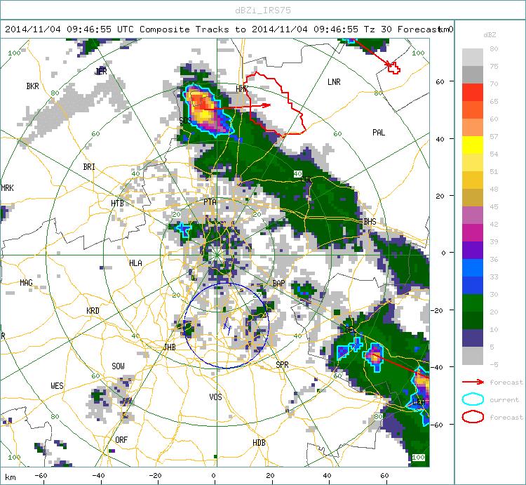
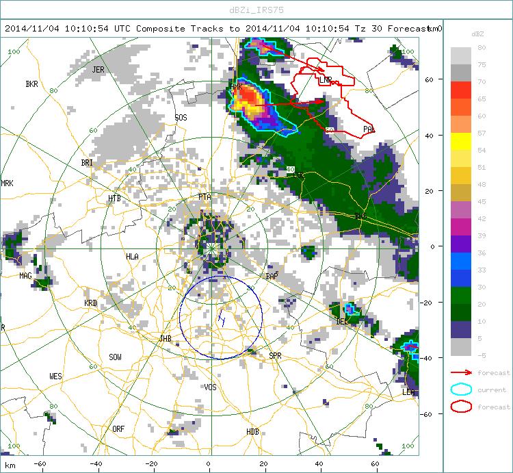
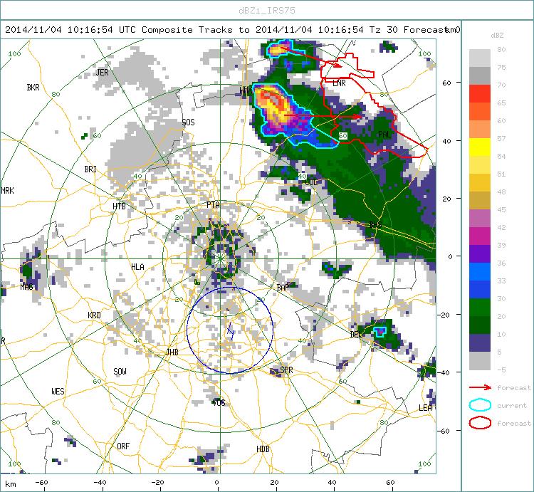
15 Case 1: 09 November UTC 1130 UTC Slide courtesy Bathobile Maseko


16 Case 2: 17 October UTC 1615 UTC Slide courtesy Bathobile Maseko
17 RDT: Examples from case studies comparing to TRMM rainfall data

18 Case 3: 28 December ZIMBABWE Slide courtesy Bathobile Maseko
19 Case 3: 28 December Slide courtesy Bathobile Maseko
20 RDT: Recent (v2013) examples


21 Case 1: 10 October 2014 Slide courtesy Bathobile Maseko


22 Case 2: 11 October 2014 Slide courtesy Bathobile Maseko

23 Case 3: 5 June

24 Case 3: Compared to radar at 1630 UTC 24

25 Case 4: 20 September 2014 Afternoon thunderstorms and hail in JhB 25

26 Case 5: 10 August 2014 from 1200 to 1445 UTC


27 Case 6: 28 Sep 2014 Radar 1045 UTC 27

28 Case 7: 6 Oct UTC - Namibia 28

29 29 Case 8: Yesterday
30 30 Hail/tornado?
31 Validation of RDT by the developers (in France) RDT provides an accurate depiction of convective phenomena, from triggering phase to mature stage. The RDT object allows pointing out some areas of interest of a satellite image. It provides relevant information on triggering and development clouds and on mature systems. The subjective evaluation confirmed the usefulness of the RDT with moderate lightning activity. Thanks to these good results the status of RDT has been set up to operational by EUMETSAT in
32 Validation of RDT by Hungarian Weather Service (v2009) It detects the majority of the mature phase convective clouds. The small and/or warm cells are often missed Better performance in pure convective situation than in frontal situation. Sometimes a huge part of a front is detected as convective. We have verified RDT without the optional lightning input. If we used lightning as input, we would get better results. 32
33 Validation of RDT in SA 24 Lightning detection sensors over SA domain which measures CLOUD-GROUND Advantages: Complete coverage of SA 90% or more of Cloud-to-ground (CG) lightning strokes can be detected. Disadvantages: Only CG lightning detected Intra-cloud lightning (IC) not detected. This can negatively impact on the evaluations since some lightning is not observed. Lightning occurs in all thunderstorms, not just rapidly developing thunderstorms. This can negatively impact the statistics unless one distinguishes between the intensities of the strokes. Slide courtesy Morne Gijben 33
34 Validation methodology Used Mature and growing phase storms (Most CG lightning) Considered lightning intensities (similar to developers of RDT) Lightning intensities defined as: Low: >3 strokes (1 flash x 3) Moderate: >15 strokes (5 flashes x 3) Severe: >60 strokes (15 flashes x 3) Slide courtesy Morne Gijben

35 Results for 10 cases over SA Slide courtesy Morne Gijben

36 Slide courtesy Morne Gijben 36

37 Slide courtesy Morne Gijben 37
38 Hanssen-Kuipers Discriminant - Average of 10 Cases TIME (UTC) 3 Strokes 15 Strokes 60 Strokes 38
39 Validation results Statistics show: Fair amount of lightning occurs inside the RDT polygons. POD, POFD and HKD are good FAR are too high due to grid-box-based validation methods. Object orientated methodology is better to use. This is future work. Visual and statistical evaluations show that RDT polygons correctly identify the storms which produce lightning. Slide courtesy Morne Gijben 39
40 Validation future plans We are looking into improving our evaluation methodology by using an object-orientated evaluation technique on both the RDT polygons and lightning. Include lightning data as input into RDT Test the 2013 version of NowSAF software (operational) The NOWSAF products are also updated regularly, so we can look forward to even better products in the future. Slide courtesy Morne Gijben 40
41 41
42 Back to 16 October 2014 WIND ARROWS INDICATE DIRECION AND SPEED OF MOVEMENT NOWCASTING! 42

43 Tornado time to 1000 UTC 43
44 Conclusion For the initial work, the v2012 of the software was used, the latest version of the software (v2013) is now operational in SA. Improvements in the software algorithms will possibly have even better validation results RDT showed very promising results to be used in addition to other observations such as radar and lightning detection in SA, where these are available In regions without radar systems and/or lightning detection networks, these satellite and NWP products will certainly benefit nowcasting procedures. RDT - Images for SADC and SA regions on RSMC for past 2 hours
45 RDT Summary and Future work The RDT can provide useful information on the development and phase of the intense parts of thunderstorms over data sparse regions such as Africa. If we upgrade to UM on 4 or 1.5 km we will also see improvement to RDT (Sfc Press/925 hpa included) Nowcasting applications in South Africa to complement the radar data (where available) Nowcasting applications in southern Africa where very few radar systems are operationally available Validation against lightning data over SA domain showed promising results. Methodology will be improved with time. Nowcasting on direction/speed of identified storms! 45
Rapidly Developing Thunderstorm (RDT)
") Rapidly Developing Thunderstorm (RDT) Jean-Marc Moisselin, Frédéric Autones Météo-France Nowcasting Department 42, av. Gaspard Coriolis 31057 Toulouse France jean-marc.moisselin@meteo.fr EUMETRAIN Convection
Rapidly Developing Thunderstorm (RDT) Jean-Marc Moisselin, Frédéric Autones Météo-France Nowcasting Department 42, av. Gaspard Coriolis 31057 Toulouse France jean-marc.moisselin@meteo.fr EUMETRAIN Convection
RDT-CW: TOWARD A MULTIDIMENSIONAL DESCRIPTION OF CONVECTION
 RDT-CW: TOWARD A MULTIDIMENSIONAL DESCRIPTION OF CONVECTION Jean-Marc Moisselin, Frederic Autonès Météo-France, DPREVI/PI, 42 avenue G. Coriolis 31057 Toulouse, France Abstract RDT-CW (Rapid Development
"Experiences with use of EUMETSAT MPEF GII product for convection/storm nowcasting"
 "Experiences with use of EUMETSAT MPEF GII product for convection/storm nowcasting" Marianne König 1, Monika Pajek 2, Piotr Struzik 2 1) EUMETSAT 2) Institute of Meteorology and Water Management, Kraków,
Nowcasting thunderstorms for aeronautical end-users
 Nowcasting thunderstorms for aeronautical end-users Jean-Marc Moisselin Météo-France, Nowcasting Department co-authors: Céline Jauffret (Météo-France) Overview Introduction SAT RADAR NWP image crédit:
Utilising Radar and Satellite Based Nowcasting Tools for Aviation Purposes in South Africa. Erik Becker
 Utilising Radar and Satellite Based Nowcasting Tools for Aviation Purposes in South Africa Erik Becker Morné Gijben, Mary-Jane Bopape, Stephanie Landman South African Weather Service: Nowcasting and Very
Nowcasting of Severe Weather from Satellite Images (for Southern
 Nowcasting of Severe Weather from Satellite Images (for Southern Europe) Petra Mikuš Jurković Forecasting/ nowcasting of convective storms NWP models cannot well predict the exact location and intesity
Judit Kerényi. OMSZ - Hungarian Meteorological Service, Budapest, Hungary. H-1525 Budapest, P.O.Box 38, Hungary.
 SATELLITE-DERIVED PRECIPITATION ESTIMATIONS DEVELOPED BY THE HYDROLOGY SAF PROJECT CASE STUDIES FOR THE INVESTIGATION OF THEIR ACCURACY AND FEATURES IN HUNGARY Judit Kerényi OMSZ - Hungarian Meteorological
USE OF SATELLITE INFORMATION IN THE HUNGARIAN NOWCASTING SYSTEM
 USE OF SATELLITE INFORMATION IN THE HUNGARIAN NOWCASTING SYSTEM Mária Putsay, Zsófia Kocsis and Ildikó Szenyán Hungarian Meteorological Service, Kitaibel Pál u. 1, H-1024, Budapest, Hungary Abstract The
PRECONVECTIVE SOUNDING ANALYSIS USING IASI AND MSG- SEVIRI
 PRECONVECTIVE SOUNDING ANALYSIS USING IASI AND MSG- SEVIRI Marianne König, Dieter Klaes EUMETSAT, Eumetsat-Allee 1, 64295 Darmstadt, Germany Abstract EUMETSAT operationally generates the Global Instability
Page 1/8 Long duration validation of PGE11. SAF - Nowcasting Product Assessment Review Worshop (Madrid ctober 2005
 Page 1/8 Plan Research activity (visiting scientist: Oleksiy Kryvobok) Use of other PGEs and HRVis for RDT improvement Tuning PGE11 satellite-based discrimination using SEVIRI data Long duration validation
CHARACTERISATION OF STORM SEVERITY BY USE OF SELECTED CONVECTIVE CELL PARAMETERS DERIVED FROM SATELLITE DATA
 CHARACTERISATION OF STORM SEVERITY BY USE OF SELECTED CONVECTIVE CELL PARAMETERS DERIVED FROM SATELLITE DATA Piotr Struzik Institute of Meteorology and Water Management, Satellite Remote Sensing Centre
MSG FOR NOWCASTING - EXPERIENCES OVER SOUTHERN AFRICA
 MSG FOR NOWCASTING - EXPERIENCES OVER SOUTHERN AFRICA Estelle de Coning and Marianne König South African Weather Service, Private Bag X097, Pretoria 0001, South Africa EUMETSAT, Am Kavalleriesand 31, D-64295
DATA FUSION NOWCASTING AND NWP
 DATA FUSION NOWCASTING AND NWP Brovelli Pascal 1, Ludovic Auger 2, Olivier Dupont 1, Jean-Marc Moisselin 1, Isabelle Bernard-Bouissières 1, Philippe Cau 1, Adrien Anquez 1 1 Météo-France Forecasting Department
Combined and parallel use of MSG composite images and SAFNWC/MSG products at the Hungarian Meteorological Service
 Combined and parallel use of MSG composite images and SAFNWC/MSG products at the Hungarian Meteorological Service Mária Putsay, Kornél Kolláth and Ildikó Szenyán Hungarian Meteorological Service H-1525
Judit Kerényi. OMSZ-Hungarian Meteorological Service P.O.Box 38, H-1525, Budapest Hungary Abstract
 Comparison of the precipitation products of Hydrology SAF with the Convective Rainfall Rate of Nowcasting-SAF and the Multisensor Precipitation Estimate of EUMETSAT Judit Kerényi OMSZ-Hungarian Meteorological
MAIN ATTRIBUTES OF THE PRECIPITATION PRODUCTS DEVELOPED BY THE HYDROLOGY SAF PROJECT RESULTS OF THE VALIDATION IN HUNGARY
 MAIN ATTRIBUTES OF THE PRECIPITATION PRODUCTS DEVELOPED BY THE HYDROLOGY SAF PROJECT RESULTS OF THE VALIDATION IN HUNGARY Eszter Lábó OMSZ-Hungarian Meteorological Service, Budapest, Hungary labo.e@met.hu
INTERPRETATION OF MSG IMAGES, PRODUCTS AND SAFNWC OUTPUTS FOR DUTY FORECASTERS
 INTERPRETATION OF MSG IMAGES, PRODUCTS AND SAFNWC OUTPUTS FOR DUTY FORECASTERS M. Putsay, M. Rajnai, M. Diószeghy, J. Kerényi, I.G. Szenyán and S. Kertész Hungarian Meteorological Service, H-1525 Budapest,
Satellite-based Convection Nowcasting and Aviation Turbulence Applications
 Satellite-based Convection Nowcasting and Aviation Turbulence Applications Kristopher Bedka Cooperative Institute for Meteorological Satellite Studies (CIMSS), University of Wisconsin-Madison In collaboration
NWC-SAF Satellite Application Facility in Support to Nowcasting and Very Short Range Forecasting
 NWC-SAF Satellite Application Facility in Support to Nowcasting and Very Short Range Forecasting Marianne König Slide 1 Satellite Application Facilities (SAFs) in Europe Member State Cooperating State
Early detection of thunderstorms using satellite, radar and
 Federal Department of Home of Home Affairs Affairs FDHA FDHA Federal Office of of Meteorology and and Climatology MeteoSwiss Early detection of thunderstorms using satellite, radar and Observing convection
REPORT ON THE ACTIVITIES OF THE EUMETSAT-ESSL CONVECTION WORKING GROUP
 REPORT ON THE ACTIVITIES OF THE EUMETSAT-ESSL CONVECTION WORKING GROUP Marianne König EUMETSAT, Eumetsat Allee 1, 64295 Darmstadt, Germany Abstract The focus of the Convection Working Group is to have
OBJECTIVE USE OF HIGH RESOLUTION WINDS PRODUCT FROM HRV MSG CHANNEL FOR NOWCASTING PURPOSES
 OBJECTIVE USE OF HIGH RESOLUTION WINDS PRODUCT FROM HRV MSG CHANNEL FOR NOWCASTING PURPOSES José Miguel Fernández Serdán, Javier García Pereda Servicio de Técnicas de Análisis y Predicción, Servicio de
The use of RDT in the HAIC project
 The use of RDT in the HAIC project Jean-Marc Moisselin Météo-France, Nowcasting Department co-authors: Christine Le Bot (Météo-France), Pierre Rieu (Météo-France), Amanda Gounou (MétéoFrance), Eric Defer
Satellite-based thunderstorm tracking, monitoring and nowcasting over South Africa
 Satellite-based thunderstorm tracking, monitoring and nowcasting over South Africa Caroline Forster 1, Estelle de Coning 2, Sebastian Diebel 1, Tobias Zinner 3 EUMETSAT Meteorological Satellite Conference
Introduction to the NWC SAF
 Introduction to the NWC SAF NWC SAF Event Week EUMeTrain course 18-22 November, online P. Fernández 1 Where are you listening from? Contents SAF Network scope NWC SAF Overview Products Next versions 2014
The Nowcasting Demonstration Project for London 2012
 The Nowcasting Demonstration Project for London 2012 Susan Ballard, Zhihong Li, David Simonin, Jean-Francois Caron, Brian Golding, Met Office, UK Introduction The success of convective-scale NWP is largely
Validation Report for Precipitation products from Cloud Physical Properties (PPh-PGE14: PCPh v1.0 & CRPh v1.0)
") Page: 1/26 Validation Report for Precipitation SAF/NWC/CDOP2/INM/SCI/VR/15, Issue 1, Rev. 0 15 July 2013 Applicable to SAFNWC/MSG version 2013 Prepared by AEMET Page: 2/26 REPORT SIGNATURE TABLE Function
Page: 1/26 Validation Report for Precipitation SAF/NWC/CDOP2/INM/SCI/VR/15, Issue 1, Rev. 0 15 July 2013 Applicable to SAFNWC/MSG version 2013 Prepared by AEMET Page: 2/26 REPORT SIGNATURE TABLE Function
VALIDATION RESULTS OF THE OPERATIONAL LSA-SAF SNOW COVER MAPPING
 VALIDATION RESULTS OF THE OPERATIONAL LSA-SAF SNOW COVER MAPPING Niilo Siljamo, Otto Hyvärinen Finnish Meteorological Institute, Erik Palménin aukio 1, P.O.Box 503, FI-00101 HELSINKI Abstract Hydrological
Meteosat Third Generation (MTG): Lightning Imager and its products Jochen Grandell
: Lightning Imager and its products Jochen Grandell") 1 Go to View menu and click on Slide Master to update this footer. Include DM reference, version number and date Meteosat Third Generation (MTG): Lightning Imager and its products Jochen Grandell Topics
1 Go to View menu and click on Slide Master to update this footer. Include DM reference, version number and date Meteosat Third Generation (MTG): Lightning Imager and its products Jochen Grandell Topics
OPERATIONAL USE OF METEOSAT-8 SEVIRI DATA AND DERIVED NOWCASTING PRODUCTS. Nataša Strelec Mahović
 OPERATIONAL USE OF METEOSAT-8 SEVIRI DATA AND DERIVED NOWCASTING PRODUCTS Nataša Strelec Mahović Meteorological and Hydrological Service Grič 3, 10 000 Zagreb, Croatia strelec@cirus.dhz.hr ABSTRACT Meteosat-8
EUMETSAT SAF NETWORK. Lothar Schüller, EUMETSAT SAF Network Manager
 1 EUMETSAT SAF NETWORK Lothar Schüller, EUMETSAT SAF Network Manager EUMETSAT ground segment overview METEOSAT JASON-2 INITIAL JOINT POLAR SYSTEM METOP NOAA SATELLITES CONTROL AND DATA ACQUISITION FLIGHT
DESCRIPTION AND VALIDATION RESULTS OF THE HIGH RESOLUTION WIND PRODUCT FROM HRVIS MSG CHANNEL, AT EUMETSAT NOWCASTING SAF (SAFNWC)
") DESCRIPTION AND VALIDATION RESULTS OF THE HIGH RESOLUTION WIND PRODUCT FROM HRVIS MSG CHANNEL, AT EUMETSAT NOWCASTING SAF (SAFNWC) Javier García Pereda, José Miguel Fernández Serdán Servicio de Teledetección,
DESCRIPTION AND VALIDATION RESULTS OF THE HIGH RESOLUTION WIND PRODUCT FROM HRVIS MSG CHANNEL, AT EUMETSAT NOWCASTING SAF (SAFNWC) Javier García Pereda, José Miguel Fernández Serdán Servicio de Teledetección,
Hail nowcast exploiting radar and satellite observations
 Federal Department of Home Affairs FDHA Federal Office of Meteorology and Climatology MeteoSwiss Hail nowcast exploiting radar and satellite observations Ulrich Hamann, Elena Leonarduzzi, Kristopher Bedka,
Model enhancement & delivery plans, RAI
 Model enhancement & delivery plans, RAI Karen McCourt, UK VCP Manager 12 th June 2013 Outline Current model outputs & dissemination Future model outputs & dissemination New website for dissemination to
Description of the case study
 Description of the case study During the night and early morning of the 14 th of July 011 the significant cloud layer expanding in the West of the country and slowly moving East produced precipitation
Lightning Detection Systems
 Lightning Detection Systems Roger Carter, Spectrum Manager, UK Met Office ITU/WMO SEMINAR ON USE OF RADIO SPECTRUM FOR METEOROLOGY. 16 18 September 2009 Lightning Detection Systems Table of Contents Introduction
WMO Aeronautical Meteorology Scientific Conference 2017
 Session 1 Science underpinning meteorological observations, forecasts, advisories and warnings 1.1 En route phenomena 1.1.1 Ice crystal icing, and airframe icing research The use of RDT in the HAIC project
NEW SCHEME TO IMPROVE THE DETECTION OF RAINY CLOUDS IN PUERTO RICO
 NEW SCHEME TO IMPROVE THE DETECTION OF RAINY CLOUDS IN PUERTO RICO Joan Manuel Castro Sánchez Advisor Dr. Nazario Ramirez UPRM NOAA CREST PRYSIG 2016 October 7, 2016 Introduction A cloud rainfall event
Warning procedures for extreme events in the Emilia-Romagna Region
 Warning procedures for extreme events in the Emilia-Romagna Region Anna Fornasiero, Miria Celano, Roberta Amorati, Virginia Poli and Pier Paolo Alberoni Arpa Emilia-Romagna Hydro-Meteo-Climate Service,
SAFNWC/MSG SEVIRI CLOUD PRODUCTS
 SAFNWC/MSG SEVIRI CLOUD PRODUCTS M. Derrien and H. Le Gléau Météo-France / DP / Centre de Météorologie Spatiale BP 147 22302 Lannion. France ABSTRACT Within the SAF in support to Nowcasting and Very Short
Air Mass Thunderstorms. Air Mass Thunderstorms. Air Mass Thunderstorms. Lecture 26 Air Mass Thunderstorms and Lightning
 Lecture 26 and Lightning Life Cycle Environment Climatology Lightning 1 2 Short-lived, isolated thunderstorms that are not severe are often called air-mass thunderstorms. There are three stages describing
AOMSUC-6 Training Event
 Effective use of high temporal and spatial resolution Himawari-8 data AOMSUC-6 Training Event Bodo Zeschke Australian Bureau of Meteorology Training Centre Australian VLab Centre of Excellence Content
MSGVIEW: AN OPERATIONAL AND TRAINING TOOL TO PROCESS, ANALYZE AND VISUALIZATION OF MSG SEVIRI DATA
 MSGVIEW: AN OPERATIONAL AND TRAINING TOOL TO PROCESS, ANALYZE AND VISUALIZATION OF MSG SEVIRI DATA Aydın Gürol Ertürk Turkish State Meteorological Service, Remote Sensing Division, CC 401, Kalaba Ankara,
H-SAF future developments on Convective Precipitation Retrieval
 H-SAF future developments on Convective Precipitation Retrieval Francesco Zauli 1, Daniele Biron 1, Davide Melfi 1, Antonio Vocino 1, Massimiliano Sist 2, Michele De Rosa 2, Matteo Picchiani 2, De Leonibus
EUMETSAT SAF NETWORK. Lothar Schüller, EUMETSAT SAF Network Manager
 1 EUMETSAT SAF NETWORK Lothar Schüller, EUMETSAT SAF Network Manager EUMETSAT ground segment overview METEOSAT JASON-2 INITIAL JOINT POLAR SYSTEM METOP NOAA SATELLITES CONTROL AND DATA ACQUISITION FLIGHT
Global Instability Index: Product Guide
 Doc.No. Issue : : EUM/TSS/MAN/15/802106 v1c e-signed EUMETSAT Eumetsat-Allee 1, D-64295 Darmstadt, Germany Tel: +49 6151 807-7 Fax: +49 6151 807 555 Date : 2 September 2015 http://www.eumetsat.int WBS/DBS
A statistical approach for rainfall confidence estimation using MSG-SEVIRI observations
 A statistical approach for rainfall confidence estimation using MSG-SEVIRI observations Elisabetta Ricciardelli*, Filomena Romano*, Nico Cimini*, Frank Silvio Marzano, Vincenzo Cuomo* *Institute of Methodologies
METEOSAT CONVECTIVE INITIATION PRODUCT WITH AND WITHOUT CLOUD TRACKING - EXPERIENCES
 METEOSAT CONVECTIVE INITIATION PRODUCT WITH AND WITHOUT CLOUD TRACKING - EXPERIENCES Mária Putsay 1, Zsófia Kocsis 1, Marianne König 2, Ildikó Szenyán 1, Márta Diószeghy 1, André Simon 1 and Márk Rajnai
Use of lightning data to improve observations for aeronautical activities
 Use of lightning data to improve observations for aeronautical activities Françoise Honoré Jean-Marc Yvagnes Patrick Thomas Météo_France Toulouse France I Introduction Aeronautical activities are very
Aviation Hazards: Thunderstorms and Deep Convection
 Aviation Hazards: Thunderstorms and Deep Convection TREND Diagnosis of thunderstorm hazards using imagery Contents Satellite imagery Visible, infrared, water vapour Basic cloud identification Identifying
Observations needed for verification of additional forecast products
 Observations needed for verification of additional forecast products Clive Wilson ( & Marion Mittermaier) 12th Workshop on Meteorological Operational Systems, ECMWF, 2-6 November 2009 Additional forecast
Plan for operational nowcasting system implementation in Pulkovo airport (St. Petersburg, Russia)
") Plan for operational nowcasting system implementation in Pulkovo airport (St. Petersburg, Russia) Pulkovo airport (St. Petersburg, Russia) is one of the biggest airports in the Russian Federation (150
Plan for operational nowcasting system implementation in Pulkovo airport (St. Petersburg, Russia) Pulkovo airport (St. Petersburg, Russia) is one of the biggest airports in the Russian Federation (150
H-SAF VSA Programme HSAF_ CDOP2_VS14_03
 H-SAF VSA Programme HSAF_ CDOP2_VS14_03 Improvements on the PR-OBS-6 H-SAF precipitation product using multispectral markers from geostationary satellite data Final report Index 1. SCOPE OF THE DOCUMENT...
The importance of satellite data and products for RA1 in the WWRP strategy. Estelle de Coning World Weather Research Division
 The importance of satellite data and products for RA1 in the WWRP strategy Estelle de Coning World Weather Research Division Kofi Annan former UN Secretary-General (21 July 2016) "The poor need alerts
NOWCASTING PRODUCTS BASED ON MTSAT-1R RAPID SCAN OBSERVATION. In response to CGMS Action 38.33
 CGMS-39, JMA-WP-08 Prepared by JMA Agenda Item: G.II/8 Discussed in WG II NOWCASTING PRODUCTS BASED ON MTSAT-1R RAPID SCAN OBSERVATION In response to CGMS Action 38.33 This document reports on JMA s MTSAT-1R
The WMO Aviation Research & Demonstration Project (AvRDP) at Paris-CDG airport. Pauline Jaunet Météo-France
 at Paris-CDG airport. Pauline Jaunet Météo-France") The WMO Aviation Research & Demonstration Project (AvRDP) at Paris-CDG airport Pauline Jaunet Météo-France AvRDP focus points Aviation Research Demonstration Project Joint effort between CAS/WWRP and CaeM
The WMO Aviation Research & Demonstration Project (AvRDP) at Paris-CDG airport Pauline Jaunet Météo-France AvRDP focus points Aviation Research Demonstration Project Joint effort between CAS/WWRP and CaeM
Applications of multi-spectral satellite data
 Applications of multi-spectral satellite data Jochen Kerkmann EUMETSAT, Satellite Meteorologist, Training Officer Adjusted by E de Coning South African Weather Service Content 1. Why should we use RGBs?
The importance of satellite data for nowcasting in the WWRP strategy
 The importance of satellite data for nowcasting in the WWRP strategy Estelle de Coning and Paolo Ruti World Weather Research Division Steve Goodman Chief Program Scientist, NOAA WMO definition Nowcasting
Using McIDAS-V for Satellite-Based Thunderstorm Research and Product Development
 Using McIDAS-V for Satellite-Based Thunderstorm Research and Product Development Kristopher Bedka UW-Madison, SSEC/CIMSS In Collaboration With: Tom Rink, Jessica Staude, Tom Whittaker, Wayne Feltz, and
Aviation Hazards: Thunderstorms and Deep Convection
 Aviation Hazards: Thunderstorms and Deep Convection TREND Empirical thunderstorm forecasting techniques Contents Necessary conditions for convection: Instability Low-level moisture Trigger mechanism Forecasting
10/21/2012. Chapter 10 Thunderstorms. Part II. Growth and Development of ordinary Cell Thunderstorms Thunderstorm Electrification.
 Chapter 10 Thunderstorms Part I Growth and Development of ordinary Cell Thunderstorms Thunderstorm Electrification Tornadoes Part II Simplified model depicting the life cycle of an ordinary thunderstorm
QUALITY OF MPEF DIVERGENCE PRODUCT AS A TOOL FOR VERY SHORT RANGE FORECASTING OF CONVECTION
 QUALITY OF MPEF DIVERGENCE PRODUCT AS A TOOL FOR VERY SHORT RANGE FORECASTING OF CONVECTION C.G. Georgiev 1, P. Santurette 2 1 National Institute of Meteorology and Hydrology, Bulgarian Academy of Sciences
A new Approach to the Detection and Tracking of Mesoscale Convective Systems in the Tropics using MSG
 new pproach to the Detection and Tracking of Mesoscale Convective Systems in the Tropics using MSG Courtesy of STMOS LMD Thomas Fiolleau Rémy Roca Outline of the talk Introduction the Hydrological and
SAFNWC/MSG Dust flag.
 SAFNWC/MSG Dust flag. Dust Week 1-5 March 2010 Hervé LE GLEAU, Marcel DERRIEN Centre de météorologie Spatiale. Lannion Météo-France 1 Plan SAFNWC context Dust flag in SAFNWC/MSG Cma product Algorithm description
For the operational forecaster one important precondition for the diagnosis and prediction of
 Initiation of Deep Moist Convection at WV-Boundaries Vienna, Austria For the operational forecaster one important precondition for the diagnosis and prediction of convective activity is the availability
Figure 5: Comparison between SAFIR warning and radar-based hail detection for the hail event of June 8, 2003.
 SAFIR WARNING : Expected risk Radar-based Probability of Hail 0915 0930 0945 1000 Figure 5: Comparison between SAFIR warning and radar-based hail detection for the hail event of June 8, 2003. Lightning
NOAA/NESDIS Tropical Web Page with LEO Satellite Products and Applications for Forecasters
 NOAA/NESDIS Tropical Web Page with LEO Satellite Products and Applications for Forecasters Sheldon Kusselson National Oceanic and Atmospheric Administration (NOAA) National Environmental Satellite Data
National Public Weather and Warning Services in the Swaziland Meteorological Service Dennis S.Mkhonta /
 National Public Weather and Warning Services in the Swaziland Meteorological Service Dennis S.Mkhonta dennis.mkhonta@gmail.com / dennis@swazimet.gov.sz Introduction Swaziland s geographical position exposes
MODIS ATMOSPHERIC PROFILES PRODUCT IN FINLAND A FEASIBILITY STUDY
 MODIS ATMOSPHERIC PROFILES PRODUCT IN FINLAND A FEASIBILITY STUDY Sauli Joro Finnish Meteorological Institute P.O.Box 503, FIN-00101 Helsinki, FINLAND sauli.joro@fmi.fi ABSTRACT The prediction of convection
Cb-LIKE: thunderstorm forecasts up to 6 hrs with fuzzy logic
 Cb-LIKE: thunderstorm forecasts up to 6 hrs with fuzzy logic Martin Köhler DLR Oberpfaffenhofen 15th EMS/12th ECAM 07 11 September, Sofia, Bulgaria Long-term forecasts of thunderstorms why? -> Thunderstorms
NWC SAF Product Assessment Review Workshop
 NWC SAF Product Assessment Review Workshop LF López Cotín. IOP NWC SAF Manager Madrid, 17 th to19 th October2005 NWC SAF User Feedback Standard user feedback: Helpdesk, SPRs and SMRs procedure Email Strategy
Severe storms over the Mediterranean Sea: A satellite and model analysis
 National Research Council of Italy Severe storms over the Mediterranean Sea: A satellite and model analysis V. Levizzani, S. Laviola, A. Malvaldi, M. M. Miglietta, and E. Cattani 6 th International Precipitation
Strategic Radar Enhancement Project (SREP) Forecast Demonstration Project (FDP) The future is here and now
 Forecast Demonstration Project (FDP) The future is here and now") Strategic Radar Enhancement Project (SREP) Forecast Demonstration Project (FDP) The future is here and now Michael Berechree National Manager Aviation Weather Services Australian Bureau of Meteorology
Strategic Radar Enhancement Project (SREP) Forecast Demonstration Project (FDP) The future is here and now Michael Berechree National Manager Aviation Weather Services Australian Bureau of Meteorology
Cloud analysis from METEOSAT data using image segmentation for climate model verification
 Cloud analysis from METEOSAT data using image segmentation for climate model verification R. Huckle 1, F. Olesen 2 Institut für Meteorologie und Klimaforschung, 1 University of Karlsruhe, 2 Forschungszentrum
Evolution of radar and lightning parameters in summer thunderstorms
 Evolution of radar and lightning parameters in summer thunderstorms rms Rigo,, T., Argemí,, O., Bech,, J., and Pineda, N. Servei Meteorològic de Catalunya, c/berlín 38-46 Barcelona 08029, SPAIN E-mail:
APPLICATIONS OF METEOROLOGICAL SATELLITE PRODUCTS FOR SHORT TERM FORECASTING OF CONVECTION IN SOUTHERN AFRICA
 APPLICATIONS OF METEOROLOGICAL SATELLITE PRODUCTS FOR SHORT TERM FORECASTING OF CONVECTION IN SOUTHERN AFRICA by ESTELLE DE CONING submitted in accordance with the requirements for the degree of Doctor
Research on Lightning Nowcasting and Warning System and Its Application
 Research on Lightning Nowcasting and Warning System and Its Application Wen Yao Chinese Academy of Meteorological Sciences Beijing, China yaowen@camscma.cn 2016.07 1 CONTENTS 1 2 3 4 Lightning Hazards
EUMETSAT Satellite Programmes Use of McIDAS at EUMETSAT
 EUMETSAT Satellite Programmes Use of McIDAS at EUMETSAT Marianne König Peter Miu McIDAS Users' Group Meeting, 07-10 May 2012 Slide 1 EUMETSAT Headquarters Darmstadt McIDAS Users' Group Meeting, 07-10 May
FLYSAFE meteorological hazard nowcasting driven by the needs of the pilot
 FLYSAFE meteorological hazard nowcasting driven by the needs of the pilot R. W. Lunnon, Met Office, Exeter, EX1 3PB, United Kingdom., Thomas Hauf, Thomas Gerz, and Patrick Josse. 1. Introduction The FLYSAFE
Mr. P s Science Test!
 WEATHER- 2017 Mr. P s Science Test! # Name Date 1. Draw and label a weather station model. (10 pts) 2. The is the layer of the atmosphere with our weather. 3. Meteorologists classify clouds in about different
INTERPRETATION GUIDE TO MSG WATER VAPOUR CHANNELS
 INTERPRETATION GUIDE TO MSG WATER VAPOUR CHANNELS C.G. Georgiev1 and P. Santurette2 1 National Institute of Meteorology and Hydrology, Tsarigradsko chaussee 66, 1784 Sofia, Bulgaria 2 Météo-France, 42,
EUMETSAT Hydrological SAF H05 product development at CNMCA
 EUMETSAT Conference 2013 Session 3 - Quantitative applications for nowcasting Poster Presentation EUMETSAT Hydrological SAF H05 product development at CNMCA Antonio Vocino, Valentina Scappiti, Daniele
May 17, earthsciencechapter24.notebook. Apr 8 10:54 AM Review. Grade:9th. Subject:Earth Science. Date:4/8.
 Apr 8 10:54 AM 24.1 Review Grade:9th Subject:Earth Science Date:4/8 Apr 8 9:29 AM 1 1 As lower layers of air are warmed... A the air rises B winds form C the air dries D the air sinks Apr 8 9:49 AM 2 What
AMVs in the ECMWF system:
 AMVs in the ECMWF system: Overview of the recent operational and research activities Kirsti Salonen and Niels Bormann Slide 1 AMV sample coverage: monitored GOES-15 GOES-13 MET-10 MET-7 MTSAT-2 NOAA-15
CTTH Cloud Top Temperature and Height
 CTTH Cloud Top Temperature and Height 15 th June 2004 Madrid Hervé Le Gléau and Marcel Derrien Météo-France / CMS lannion 1 Plan of CTTH presentation Algorithms short description Some examples Planned
Vaisala s NLDN and GLD360 performance improvements and aviation applications. Nick Demetriades Head of Airports Vaisala 2015 Fall FPAW
 Vaisala s NLDN and GLD360 performance improvements and aviation applications Nick Demetriades Head of Airports Vaisala 2015 Fall FPAW Introduction Continuous CONUS Data Since 1989 The U.S. National Lightning
2.14 NOWCASTING THUNDERSTORMS IN COMPLEX CASES USING RADAR DATA
 2.14 NOWCASTING THUNDERSTORMS IN COMPLEX CASES USING RADAR DATA Alessandro M. Hering* 1, Stéphane Sénési 2, Paolo Ambrosetti 1, and Isabelle Bernard-Bouissières 2 1 MeteoSwiss, ML, Locarno-Monti, Switzerland
MSG Indian Ocean Data Coverage (IODC) Jochen Grandell & Sauli Joro
 Jochen Grandell & Sauli Joro") MSG Indian Ocean Data Coverage (IODC) Jochen Grandell & Sauli Joro 1 EUM/STG-SWG/42/17/VWG/03 v1, 7 8 Mach 2017 Topics Introduction MSG-IODC Overall Project Schedule Status Product validation Products
MSG Indian Ocean Data Coverage (IODC) Jochen Grandell & Sauli Joro 1 EUM/STG-SWG/42/17/VWG/03 v1, 7 8 Mach 2017 Topics Introduction MSG-IODC Overall Project Schedule Status Product validation Products
THUNDERSTORM LIGHTNING DATA
 THUNDERSTORM EVOLUTION ANALYSIS AND ESTIMATION USING RADAR AND TOTAL LIGHTNING DATA Jianhua Dai 1,2 *, Yuan Wang 1, Lei Chen 2, Lan Tao 2, Hong Lin 2 1. Department of Atmospheric Sciences, Key Laboratory
Remote Sensing Seminar 8 June 2007 Benevento, Italy. Lab 5 SEVIRI and MODIS Clouds and Fires
 Remote Sensing Seminar 8 June 2007 Benevento, Italy Lab 5 SEVIRI and MODIS Clouds and Fires Table: SEVIRI Channel Number, Wavelength (µm), and Primary Application Reflective Bands 1,2 0.635, 0.81 land/cld
Use of radar to detect weather
 2 April 2007 Welcome to the RAP Advisory Panel Meeting Use of radar to detect weather G. Brant Foote Brant Director Foote Rita Roberts Roelof Bruintjes Research Applications Program Radar principles Radio
SATELLITE SIGNATURES ASSOCIATED WITH SIGNIFICANT CONVECTIVELY-INDUCED TURBULENCE EVENTS
 SATELLITE SIGNATURES ASSOCIATED WITH SIGNIFICANT CONVECTIVELY-INDUCED TURBULENCE EVENTS Kristopher Bedka 1, Wayne Feltz 1, John Mecikalski 2, Robert Sharman 3, Annelise Lenz 1, and Jordan Gerth 1 1 Cooperative
THE LAND-SAF SURFACE ALBEDO AND DOWNWELLING SHORTWAVE RADIATION FLUX PRODUCTS
 THE LAND-SAF SURFACE ALBEDO AND DOWNWELLING SHORTWAVE RADIATION FLUX PRODUCTS Bernhard Geiger, Dulce Lajas, Laurent Franchistéguy, Dominique Carrer, Jean-Louis Roujean, Siham Lanjeri, and Catherine Meurey
LANDSAF SNOW COVER MAPPING USING MSG/SEVIRI DATA
 LANDSAF SNOW COVER MAPPING USING MSG/SEVIRI DATA Niilo Siljamo and Otto Hyvärinen Finnish Meteorological Institute, Erik Palménin aukio 1, P.O.Box 503, FI-00101 Helsinki, Finland Abstract Land Surface
22nd-26th February th International Wind Workshop Tokyo, Japan
 New developments in the High Resolution Winds Product (HRW), at the Satellite Application Facility on support to Nowcasting and Very short range forecasting (NWCSAF) 22nd-26th February 2010 10th International
Synergie PC Updates and Plans. A. Lasserre-Bigorry, B. Benech M-F Voidrot, & R. Giraud
 Synergie PC Updates and Plans A. Lasserre-Bigorry, B. Benech M-F Voidrot, & R. Giraud 1 2 3 4 Introduction Migration to PC-Linux Synergie 4.0 features Perspectives for 2006 ECMWF 10 th Workshop on Meteorological
Sandrine Cazabat, Michel Bouzom, Jérôme Reynaud
 7.08 NOWCASTING THUNDERSTORMS WITH SIGOONS A SIGNIFICANT WEATHER OBJECT ORIENTED NOWCASTING SYSTEM Pascal Brovelli *, Stéphane Sénési, Etienne Arbogast, Philippe Cau, Sandrine Cazabat, Michel Bouzom, Jérôme
Current Status of COMS AMV in NMSC/KMA
 Current Status of COMS AMV in NMSC/KMA Eunha Sohn, Sung-Rae Chung, Jong-Seo Park Satellite Analysis Division, NMSC/KMA soneh0431@korea.kr COMS AMV of KMA/NMSC has been produced hourly since April 1, 2011.
Introduction to Meteorology and Weather Forecasting
 Introduction to Meteorology and Weather Forecasting ENVI1400 : Meteorology and Forecasting : lecture 1 2 040909 ENVI1400 : Meteorology and Forecasting : lecture 1 3 040914 ENVI1400 : Meteorology and Forecasting
Scientific and Validation Report for the Extrapolated Imagery Processor of the NWC/GEO
 Page: 1/95 the Extrapolated Imagery Processor of the NWC/GEO NWC/CDOP2/GEO/ZAMG/SCI/VR/EXIM, Issue 1.0 22 May 2017 Applicable to GEO-EXIM-v1.0 (NWC-043) Prepared by ZAMG Page: 2/95 REPORT SIGNATURE TABLE