Strategic Radar Enhancement Project (SREP) Forecast Demonstration Project (FDP) The future is here and now
|
|
|
- Meghan Miller
- 5 years ago
- Views:
Transcription

1 Strategic Radar Enhancement Project (SREP) Forecast Demonstration Project (FDP) The future is here and now Michael Berechree National Manager Aviation Weather Services Australian Bureau of Meteorology
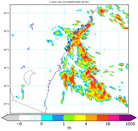
2 Strategic Radar Enhancement Project 5-year project began in 2009 Infrastructure : 4 new Doppler radars + network upgrades Science: Develop and improve the underlying science to support an enhanced weather forecasts and warning capability New science capability developed Improved radar data processing Rainfields QPE/QPF Quality control algorithms Radar mosaic visualisation Assimilation of radar into a prototype rapid update 1.5km ACCESS model

3 Sydney Forecast Demonstration Project: October December 2014 Aim To evaluate NWP and radar products Aviation - to improve operational forecasts and warnings, particularly in the 0-12 hour lead time range How Aviation forecasters participated in the project trial, real-time, in parallel with the operational forecasters Why Use the feedback to improve the design of the products and plan implementation into operations Aviation to use the product output to apply to the optimisation of airport capacity and airline operations.

4 Rapid Update Cycle (RUC) RUC: 1hr model runs 10min time steps 1.5km grid


5 1.5km model 1.5km structure 1.5km position Radar mm Satellite 4km model mm


6 Rainfields3 & 3D-Rapic Improved quality control of Doppler winds and reflectivity producing high quality radar mosaics; international data format Raw radar reflectivity Radar reflectivity raining echoes only

7 Short Term Ensemble Prediction System (STEPS) Rainfields3 blended with ACCESS1.5 to generate STEPS 30-member rainfall ensembles out to 6hrs with 6 min 1 km resolution, updated every 6 minutes x 30
 to represent convection Probability of VIL exceeding a threshold within an area or along a route Allows for a")
8 STEPS Blends radar and model 30 member ensemble 6 minute, 1km resolution, 6 hrs 6 minute updates Can be adapted for aviation Use vertically integrated liquid water (VIL) to represent convection Probability of VIL exceeding a threshold within an area or along a route Allows for a risk-based approach

9 Calibrated Thunderstorm Guidance Use lagged ensemble ACCESS1.5 to generate convective weather outlooks

10 Thunderstorm Interactive Forecast System (TIFS) Thunderstorm cell tracks using STEPS motion vectors Rainfields3 rain probability forecasts for areas of imminent storm threat Pixel-scale verification Forecaster layer control

11 Thunderstorm Findings National Thunderstorm Forecast Guidance System (NTFGS) - RUC Calibrated Thunderstorms was able to pick areas of convection that were not picked well by other models. The model appeared to excel in the timing of onset and clearance of thunderstorms from the metro area, as well as the general trend in intensity. Issues that require further investigation include: Overestimation of thunderstorm probabilities. Slightly optimistic on clearance times. There is a requirement to see how the model handles heat-based convection vs synoptically forced convection.

12 Sea breeze - Findings Model performed well on timing the sea breeze wind shift towards the coast. Some issues with correctly propagating the wind shift inland. There is a requirement to investigate propagation of seabreeze inland and frictional factors.

13 Fog - Findings RUC appears to be able to pick the difference between fog and low cloud well. To some extent the RUC appears to be able to differentiate between mist from fog. RUC was able to pick a post-rain fog event. However, this capability needs to be further examined using a few more events. There is required to further verify the capability of the model in during an additional fog season.

14 Precipitation - Findings Limited data was examined with respect to precipitation The RUC performed well in specific scenarios however, there is a need to further investigate precipitation fields and additional scenarios. RUC seemed to pick precipitation types, however forecasters need to be careful of precipitation output
15 Aviation Forecasting Principally focussed on thunderstorm and wind change Evaluated ACCESS1.5 at Sydney airport Generation and verification of TAFs Strategies for Meeting Aviation Requirements Base the services on high resolution NWP rather than empirical algorithms, e.g. fog. Structured evaluation of NWP updates from an aviation perspective will allow the NWP scientists to calibrate their models appropriately. Will still have some error in the forecasts so need to develop risk based approaches. Need to integrate high resolution NWP with high resolution satellite and radar imageries.
16 Future Research Thunderstorms: Further investigate how the model handles heat-based convection vs synoptically forced convection. Seabreeze: Investigate the propagation of seabreeze inland and frictional factors. Strong coastal wind changes: Further investigate the parameters in the model which are causing timing issues on major wind changes. Upper Winds: The model appears to handle upper-wind well but there is a requirement to see further evidence. Precipitation: these fields require further investigation in different scenarios. Fog forecasting: There is a requirement to verify the capability further in a fog season. Further investigation is required for post-fog event. Low level temperatures, dewpoint temperatures and surface inversions: fine tuning of surface temperatures and dewpoints may lead to improvements in forecasting inversions; however further investigation is required to address moisture profile.
On the use of radar rainfall estimates and nowcasts in an operational heavy rainfall warning service
 On the use of radar rainfall estimates and nowcasts in an operational heavy rainfall warning service Alan Seed, Ross Bunn, Aurora Bell Bureau of Meteorology Australia The Centre for Australian Weather
QPE and QPF in the Bureau of Meteorology
 QPE and QPF in the Bureau of Meteorology Current and future real-time rainfall products Carlos Velasco (BoM) Alan Seed (BoM) and Luigi Renzullo (CSIRO) OzEWEX 2016, 14-15 December 2016, Canberra Why do
Aurora Bell*, Alan Seed, Ross Bunn, Bureau of Meteorology, Melbourne, Australia
 15B.1 RADAR RAINFALL ESTIMATES AND NOWCASTS: THE CHALLENGING ROAD FROM RESEARCH TO WARNINGS Aurora Bell*, Alan Seed, Ross Bunn, Bureau of Meteorology, Melbourne, Australia 1. Introduction Warnings are
Challenges in providing effective flood forecasts and warnings
 Challenges in providing effective flood forecasts and warnings National Centre for Flood Research Inaugural Symposium Justin Robinson Bureau of Meteorology October 2018 Zero Lives Lost A key responsibility
TIFS DEVELOPMENTS INSPIRED BY THE B08 FDP. John Bally, A. J. Bannister, and D. Scurrah Bureau of Meteorology, Melbourne, Victoria, Australia
 P13B.11 TIFS DEVELOPMENTS INSPIRED BY THE B08 FDP John Bally, A. J. Bannister, and D. Scurrah Bureau of Meteorology, Melbourne, Victoria, Australia 1. INTRODUCTION This paper describes the developments
Progress in Aviation Weather Forecasting for ATM Decision Making FPAW 2010
 Progress in Aviation Weather Forecasting for ATM Decision Making FPAW 2010 Jim Evans Marilyn Wolfson 21 October 2010-1 Overview (1) Integration with storm avoidance models and ATC route usage models (2)
Assimilation of Doppler radar observations for high-resolution numerical weather prediction
 Assimilation of Doppler radar observations for high-resolution numerical weather prediction Susan Rennie, Peter Steinle, Mark Curtis, Yi Xiao, Alan Seed Introduction Numerical Weather Prediction (NWP)
0-6 hour Weather Forecast Guidance at The Weather Company. Steven Honey, Joseph Koval, Cathryn Meyer, Peter Neilley The Weather Company
 1 0-6 hour Weather Forecast Guidance at The Weather Company Steven Honey, Joseph Koval, Cathryn Meyer, Peter Neilley The Weather Company TWC Forecasts: Widespread Adoption 2 0-6 Hour Forecast Details 3
At the start of the talk will be a trivia question. Be prepared to write your answer.
 Operational hydrometeorological forecasting activities of the Australian Bureau of Meteorology Thomas Pagano At the start of the talk will be a trivia question. Be prepared to write your answer. http://scottbridle.com/
Aviation Hazards: Thunderstorms and Deep Convection
 Aviation Hazards: Thunderstorms and Deep Convection TREND NWP Products for Thunderstorm Forecasting Contents Model choice Identifying parameters important for convection: Low-level convergence High relative
Utilising Radar and Satellite Based Nowcasting Tools for Aviation Purposes in South Africa. Erik Becker
 Utilising Radar and Satellite Based Nowcasting Tools for Aviation Purposes in South Africa Erik Becker Morné Gijben, Mary-Jane Bopape, Stephanie Landman South African Weather Service: Nowcasting and Very
The Nowcasting Demonstration Project for London 2012
 The Nowcasting Demonstration Project for London 2012 Susan Ballard, Zhihong Li, David Simonin, Jean-Francois Caron, Brian Golding, Met Office, UK Introduction The success of convective-scale NWP is largely
Xinhua Liu National Meteorological Center (NMC) of China Meteorological Administration (CMA)
 of China Meteorological Administration (CMA)") The short-time forecasting and nowcasting technology of severe convective weather for aviation meteorological services in China Xinhua Liu National Meteorological Center (NMC) of China Meteorological Administration
The short-time forecasting and nowcasting technology of severe convective weather for aviation meteorological services in China Xinhua Liu National Meteorological Center (NMC) of China Meteorological Administration
Reprint 797. Development of a Thunderstorm. P.W. Li
 Reprint 797 Development of a Thunderstorm Nowcasting System in Support of Air Traffic Management P.W. Li AMS Aviation, Range, Aerospace Meteorology Special Symposium on Weather-Air Traffic Management Integration,
Update on CoSPA Storm Forecasts
 Update on CoSPA Storm Forecasts Haig August 2, 2011 This work was sponsored by the Federal Aviation Administration under Air Force Contract No. FA8721-05-C-0002. Opinions, interpretations, conclusions,
Hyperlocal Marine Weather: What s Happening?
 Hyperlocal Marine Weather: What s Happening? André van der Westhuysen 1,2 and Jeff McQueen 1 1 NOAA / National Weather Service National Centers for Environmental Prediction 2 I.M Systems Group, Rockville
The WMO Aviation Research & Demonstration Project (AvRDP) at Paris-CDG airport. Pauline Jaunet Météo-France
 at Paris-CDG airport. Pauline Jaunet Météo-France") The WMO Aviation Research & Demonstration Project (AvRDP) at Paris-CDG airport Pauline Jaunet Météo-France AvRDP focus points Aviation Research Demonstration Project Joint effort between CAS/WWRP and CaeM
The WMO Aviation Research & Demonstration Project (AvRDP) at Paris-CDG airport Pauline Jaunet Météo-France AvRDP focus points Aviation Research Demonstration Project Joint effort between CAS/WWRP and CaeM
AVIATION APPLICATIONS OF A NEW GENERATION OF MESOSCALE NUMERICAL WEATHER PREDICTION SYSTEM OF THE HONG KONG OBSERVATORY
 P452 AVIATION APPLICATIONS OF A NEW GENERATION OF MESOSCALE NUMERICAL WEATHER PREDICTION SYSTEM OF THE HONG KONG OBSERVATORY Wai-Kin WONG *1, P.W. Chan 1 and Ivan C.K. Ng 2 1 Hong Kong Observatory, Hong
An overview of Wet Season Forecasting in the Northern Territory
 TWP-ICE Meeting November 2004 An overview of Wet Season Forecasting in the Northern Territory Lori Chappel Northern Territory Regional Forecasting Centre Australian Government Bureau of Meteorology Day
Activity Report for Australian TCWCs 2009/2012
 Activity Report for Australian TCWCs 2009/2012 7th RSMC/TCWC Co-ordination Meeting Citeko, November 2012 Mike Bergin Regional Director (Western Australia) Bureau of Meteorology Outline Significant Cyclones
NextGen Update. Cecilia Miner May, 2017
 NextGen Update Cecilia Miner May, 2017 Agenda What s changed? NextGen Background FAA NextGen Weather Architecture NextGen Weather Processor Aviation Weather Display Common Support Services - Weather NWS
National Convective Weather Forecasts Cindy Mueller
 National Convective Weather Forecasts Cindy Mueller National Center for Atmospheric Research Research Applications Program National Forecast Demonstration 2-4-6 hr Convection Forecasts Collaborative forecast
Numerical prediction of severe convection: comparison with operational forecasts
 Meteorol. Appl. 10, 11 19 (2003) DOI:10.1017/S1350482703005024 Numerical prediction of severe convection: comparison with operational forecasts Milton S. Speer 1, Lance M. Leslie 2 & L. Qi 2 1 Bureau of
Verification and performance measures of Meteorological Services to Air Traffic Management (MSTA)
") Verification and performance measures of Meteorological Services to Air Traffic Management (MSTA) Background Information on the accuracy, reliability and relevance of products is provided in terms of verification
Verification and performance measures of Meteorological Services to Air Traffic Management (MSTA) Background Information on the accuracy, reliability and relevance of products is provided in terms of verification
Seamless nowcasting. Open issues
 Federal Department of Home Affairs FDHA Federal Office of Meteorology and Climatology MeteoSwiss Seamless nowcasting INCA Open issues Pierre Eckert Matteo Buzzi, Marco Sassi, Guido della Bruna, Marco Gaia
Activities and Outlook related to Disaster Reduction in CMA
 Activities and Outlook related to Disaster Reduction in CMA WANG Bangzhong China Meteorological Administration March 15-17 2006 ADENDA Situation about MD and related disasters in CHINA Guidance for MD/RD
WWRP Implementation Plan Reporting AvRDP
 WWRP Implementation Plan Reporting AvRDP Please send you report to Paolo Ruti (pruti@wmo.int) and Sarah Jones (sarah.jones@dwd.de). High Impact Weather and its socio economic effects in the context of
New Meteorological Services Supporting ATM
 New Meteorological Services Supporting ATM Meteorological Services in the Terminal Area (MSTA)...providing MET services to support a move from Air Traffic Control (ATC) to more integrated and collaborative
Convective-scale NWP for Singapore
 Convective-scale NWP for Singapore Hans Huang and the weather modelling and prediction section MSS, Singapore Dale Barker and the SINGV team Met Office, Exeter, UK ECMWF Symposium on Dynamical Meteorology
Application and verification of ECMWF products 2016
 Application and verification of ECMWF products 2016 Icelandic Meteorological Office (www.vedur.is) Bolli Pálmason and Guðrún Nína Petersen 1. Summary of major highlights Medium range weather forecasts
Thunderstorm Forecasting and Warnings in the US: Applications to the Veneto Region
 Thunderstorm Forecasting and Warnings in the US: Applications to the Veneto Region Bill Conway Vice President Weather Decision Technologies Norman, Oklahoma, USA Andrea Rossa ARPAV Lead Scientist Centre
Weather Studies Introduction to Atmospheric Science
 Weather Studies Introduction to Atmospheric Science American Meteorological Society Chapter 1 Monitoring The Weather Credit: This presentation was prepared for AMS by Michael Leach, Professor of Geography
Convective-scale data assimilation at the UK Met Office
 Convective-scale data assimilation at the UK Met Office DAOS meeting, Exeter 25 April 2016 Rick Rawlins Hd(DAE) Acknowledgments: Bruce Macpherson and team Contents This presentation covers the following
Regional Hazardous Weather Advisory Centres (RHWACs)
") Regional Hazardous Weather Advisory Centres (RHWACs) The following outlines the criteria for the selection of RHWACs based on operational and functional requirements 1. Basic Principles The RHWAC must:
Regional Hazardous Weather Advisory Centres (RHWACs) The following outlines the criteria for the selection of RHWACs based on operational and functional requirements 1. Basic Principles The RHWAC must:
A new mesoscale NWP system for Australia
 A new mesoscale NWP system for Australia www.cawcr.gov.au Peter Steinle on behalf of : Earth System Modelling (ESM) and Weather&Environmental Prediction (WEP) Research Programs, CAWCR Data Assimilation
Indiana County Flash Flood of 22 June 2017
 Indiana County Flash Flood of 22 June 2017 By Richard H. Grumm National Weather Service State College, PA 1. Overview Slow moving thunderstorms brought 3 to 4 inches of rainfall to Indiana County, PA during
P474 SYDNEY AIRPORT WIND SHEAR ENCOUNTER - 15 APRIL 2007
 P474 SYDNEY AIRPORT WIND SHEAR ENCOUNTER - 15 APRIL 2007 Rodney Potts* 1, Barry Hanstrum 2 and Peter Dunda 2 1. CAWCR, Bureau of Meteorology, Melbourne, VIC, Australia 2. Bureau of Meteorology, Sydney,
FPAW October Pat Murphy & David Bright NWS Aviation Weather Center
 FPAW October 2014 Pat Murphy & David Bright NWS Aviation Weather Center Overview Ensemble & Probabilistic Forecasts What AWC Is Doing Now Ensemble Processor What s In Development (NOAA Aviation Weather
Module 11: Meteorology Topic 5 Content: Weather Maps Notes
 Introduction A variety of weather maps are produced by the National Weather Service and National Oceanographic Atmospheric Administration. These maps are used to help meteorologists accurately predict
Application and verification of ECMWF products 2017
 Application and verification of ECMWF products 2017 Finnish Meteorological Institute compiled by Weather and Safety Centre with help of several experts 1. Summary of major highlights FMI s forecasts are
09 December 2005 snow event by Richard H. Grumm National Weather Service Office State College, PA 16803
 09 December 2005 snow event by Richard H. Grumm National Weather Service Office State College, PA 16803 1. INTRODUCTION A winter storm produced heavy snow over a large portion of Pennsylvania on 8-9 December
Aviation Hazards: Thunderstorms and Deep Convection
 Aviation Hazards: Thunderstorms and Deep Convection TREND Empirical thunderstorm forecasting techniques Contents Necessary conditions for convection: Instability Low-level moisture Trigger mechanism Forecasting
Flash Flood Guidance System On-going Enhancements
 Flash Flood Guidance System On-going Enhancements Hydrologic Research Center, USA Technical Developer SAOFFG Steering Committee Meeting 1 10-12 July 2017 Jakarta, INDONESIA Theresa M. Modrick Hansen, PhD
p = ρrt p = ρr d = T( q v ) dp dz = ρg
 dp dz = ρg") Chapter 1: Properties of the Atmosphere What are the major chemical components of the atmosphere? Atmospheric Layers and their major characteristics: Troposphere, Stratosphere Mesosphere, Thermosphere
Chapter 1: Properties of the Atmosphere What are the major chemical components of the atmosphere? Atmospheric Layers and their major characteristics: Troposphere, Stratosphere Mesosphere, Thermosphere
Nowcasting techniques in use for severe weather operation in NMC/CMA
 WWRP NMRWG Buenos Aires Aug 2017 Nowcasting techniques in use for severe weather operation in NMC/CMA Jianjie WANG National Meteorological Center, CMA Cascading Weather Forecasting Process --- different
Plan for operational nowcasting system implementation in Pulkovo airport (St. Petersburg, Russia)
") Plan for operational nowcasting system implementation in Pulkovo airport (St. Petersburg, Russia) Pulkovo airport (St. Petersburg, Russia) is one of the biggest airports in the Russian Federation (150
Plan for operational nowcasting system implementation in Pulkovo airport (St. Petersburg, Russia) Pulkovo airport (St. Petersburg, Russia) is one of the biggest airports in the Russian Federation (150
Localized Aviation Model Output Statistics Program (LAMP): Improvements to convective forecasts in response to user feedback
: Improvements to convective forecasts in response to user feedback") Localized Aviation Model Output Statistics Program (LAMP): Improvements to convective forecasts in response to user feedback Judy E. Ghirardelli National Weather Service Meteorological Development Laboratory
Localized Aviation Model Output Statistics Program (LAMP): Improvements to convective forecasts in response to user feedback Judy E. Ghirardelli National Weather Service Meteorological Development Laboratory
Multi Radar Multi Sensor NextGen Weather Program. Presentation materials sourced from: Ken Howard HydroMet Research Group NSSL Warning R&D Division
 Multi Radar Multi Sensor NextGen Weather Program Presentation materials sourced from: Ken Howard HydroMet Research Group NSSL Warning R&D Division What is Multiple Radar Multi Sensor System () is the world
Application and verification of ECMWF products in Norway 2008
 Application and verification of ECMWF products in Norway 2008 The Norwegian Meteorological Institute 1. Summary of major highlights The ECMWF products are widely used by forecasters to make forecasts for
Blend of UKMET and GFS 3hr increments F06 to F degree downloadable grid available on WIFS
 Blend of UKMET and GFS 3hr increments F06 to F36 1.25 degree downloadable grid available on WIFS WWW.AVIATIONWEATHER.GOV/WAFS Wind, Turbulence and Cb 2 3 New Products: All diagnostics mapped to Eddy Dissipation
7.17 RAPIDS A NEW RAINSTORM NOWCASTING SYSTEM IN HONG KONG
 7.17 RAPIDS A NEW RAINSTORM NOWCASTING SYSTEM IN HONG KONG Li Ping-Wah *, Wong Wai-Kin and Edwin S.T. Lai Hong Kong Observatory, 134A Nathan Road, Kowloon, Hong Kong 1. INTRODUCTION and the numerical forecast
AOMSUC-6 Training Event
 Effective use of high temporal and spatial resolution Himawari-8 data AOMSUC-6 Training Event Bodo Zeschke Australian Bureau of Meteorology Training Centre Australian VLab Centre of Excellence Content
How the Bureau of Meteorology contributes to the integrated risk picture. Presented by Michael Berechree
 How the Bureau of Meteorology contributes to the integrated risk picture Presented by Michael Berechree Mission Meteorological Service The mission of the Bureau's Aviation Meteorological Service is to
Add NOAA nowcoast Layers to Maps
 WebEOC Maps Add-on Quick Reference Guide Add NOAA nowcoast Layers to Maps Overview With Maps Add-on, you can configure an unlimited number of map layers. These layers allow you to control the data you
Introduction to NCEP's time lagged North American Rapid Refresh Ensemble Forecast System (NARRE-TL)
") Introduction to NCEP's time lagged North American Rapid Refresh Ensemble Forecast System (NARRE-TL) Binbin Zhou 1,2, Jun Du 2, Geoff Manikin 2 & Geoff DiMego 2 1. I.M. System Group 2. EMC/NCEP/NWS/NOAA
Introduction to NCEP's time lagged North American Rapid Refresh Ensemble Forecast System (NARRE-TL) Binbin Zhou 1,2, Jun Du 2, Geoff Manikin 2 & Geoff DiMego 2 1. I.M. System Group 2. EMC/NCEP/NWS/NOAA
Montréal, 7 to 18 July 2014
 INTERNATIONAL CIVIL AVIATION ORGANIZATION WORLD METEOROLOGICAL ORGANIZATION 6/5/14 Meteorology (MET) Divisional Meeting (2014) Commission for Aeronautical Meteorology Fifteenth Session Montréal, 7 to 18
FLORA: FLood estimation and forecast in complex Orographic areas for Risk mitigation in the Alpine space
 Natural Risk Management in a changing climate: Experiences in Adaptation Strategies from some European Projekts Milano - December 14 th, 2011 FLORA: FLood estimation and forecast in complex Orographic
Recent ECMWF Developments
 Recent ECMWF Developments Tim Hewson (with contributions from many ECMWF colleagues!) tim.hewson@ecmwf.int ECMWF November 2, 2017 Outline Last Year IFS upgrade highlights 43r1 and 43r3 Standard web Chart
CHAPTER 13 WEATHER ANALYSIS AND FORECASTING MULTIPLE CHOICE QUESTIONS
 CHAPTER 13 WEATHER ANALYSIS AND FORECASTING MULTIPLE CHOICE QUESTIONS 1. The atmosphere is a continuous fluid that envelops the globe, so that weather observation, analysis, and forecasting require international
DETECTION AND FORECASTING - THE CZECH EXPERIENCE
 1 STORM RAINFALL DETECTION AND FORECASTING - THE CZECH EXPERIENCE J. Danhelka * Czech Hydrometeorological Institute, Prague, Czech Republic Abstract Contribution presents the state of the art of operational
Understanding Weather and Climate Risk. Matthew Perry Sharing an Uncertain World Conference The Geological Society, 13 July 2017
 Understanding Weather and Climate Risk Matthew Perry Sharing an Uncertain World Conference The Geological Society, 13 July 2017 What is risk in a weather and climate context? Hazard: something with the
NOAA s Severe Weather Forecasting System: HRRR to WoF to FACETS
 NOAA s Severe Weather Forecasting System: HRRR to WoF to FACETS David D NOAA / Earth System Research Laboratory / Global Systems Division Nowcasting and Mesoscale Research Working Group Meeting World Meteorological
High Resolution Numerical Weather Prediction for High Impact and Extreme Weather Events in 2014 across Southern California
 High Resolution Numerical Weather Prediction for High Impact and Extreme Weather Events in 2014 across Southern California Alex Tardy Alexander.Tardy@noaa.gov NWS San Diego Warning Coordination Meteorologist
Application and verification of ECMWF products 2017
 Application and verification of ECMWF products 2017 Slovenian Environment Agency ARSO; A. Hrabar, J. Jerman, V. Hladnik 1. Summary of major highlights We started to validate some ECMWF parameters and other
Advances in weather and climate science
 Advances in weather and climate science Second ICAO Global Air Navigation Industry Symposium (GANIS/2) 11 to 13 December 2017, Montreal, Canada GREG BROCK Scientific Officer Aeronautical Meteorology Division
Judit Kerényi. OMSZ - Hungarian Meteorological Service, Budapest, Hungary. H-1525 Budapest, P.O.Box 38, Hungary.
 SATELLITE-DERIVED PRECIPITATION ESTIMATIONS DEVELOPED BY THE HYDROLOGY SAF PROJECT CASE STUDIES FOR THE INVESTIGATION OF THEIR ACCURACY AND FEATURES IN HUNGARY Judit Kerényi OMSZ - Hungarian Meteorological
REQUIREMENTS FOR WEATHER RADAR DATA. Review of the current and likely future hydrological requirements for Weather Radar data
 WORLD METEOROLOGICAL ORGANIZATION COMMISSION FOR BASIC SYSTEMS OPEN PROGRAMME AREA GROUP ON INTEGRATED OBSERVING SYSTEMS WORKSHOP ON RADAR DATA EXCHANGE EXETER, UK, 24-26 APRIL 2013 CBS/OPAG-IOS/WxR_EXCHANGE/2.3
Regional Flash Flood Guidance and Early Warning System
 WMO Training for Trainers Workshop on Integrated approach to flash flood and flood risk management 24-28 October 2010 Kathmandu, Nepal Regional Flash Flood Guidance and Early Warning System Dr. W. E. Grabs
Improving real time observation and nowcasting RDT. E de Coning, M Gijben, B Maseko and L van Hemert Nowcasting and Very Short Range Forecasting
 Improving real time observation and nowcasting RDT E de Coning, M Gijben, B Maseko and L van Hemert Nowcasting and Very Short Range Forecasting Introduction Satellite Application Facilities (SAFs) are
Application and verification of ECMWF products 2016
 Application and verification of ECMWF products 2016 Meteorological and Hydrological Service of Croatia Lovro Kalin and Zoran Vakula 1. Summary of major highlights At Meteorological and Hydrological Service
MSG FOR NOWCASTING - EXPERIENCES OVER SOUTHERN AFRICA
 MSG FOR NOWCASTING - EXPERIENCES OVER SOUTHERN AFRICA Estelle de Coning and Marianne König South African Weather Service, Private Bag X097, Pretoria 0001, South Africa EUMETSAT, Am Kavalleriesand 31, D-64295
Nesting and LBCs, Predictability and EPS
 Nesting and LBCs, Predictability and EPS Terry Davies, Dynamics Research, Met Office Nigel Richards, Neill Bowler, Peter Clark, Caroline Jones, Humphrey Lean, Ken Mylne, Changgui Wang copyright Met Office
WMO Coordination Group on Satellite Data Requirements for Region III and IV Sept 5-8, 2016 Willemstad, Curaçao
 WMO Coordination Group on Satellite Data Requirements for Region III and IV Sept 5-8, 2016 Willemstad, Curaçao 1. Current Satellite Reception 2. Preparation for Next-Gen GOES-R JPSS 3. Satellite Data Applications
WMO AMDAR Programme Overview
 WMO AMDAR Programme Overview Bryce Ford - presenting on behalf of WMO and NOAA FPAW Nov 1, 2012 The WMO AMDAR Program AMDAR Programme Current Status WMO World Meteorological Organization (http://www.wmo.int)
Caribbean Early Warning System Workshop
 Caribbean Early Warning System Workshop Hamonization in Existing EWS April 14-16, 2016 Presenter: Shawn Boyce Caribbean Institute for Meteorology and Hydrology Husbands, St. James Barbados Background Between
Seamless Probabilistic Forecasts for Civil Protection: from week to minutes
 Seamless Probabilistic Forecasts for Civil Protection: from week to minutes Yong Wang, Clemens Wastl, Andre Simon, Mihaly Szűcs ZAMG and HMS An EU project Bridging of Probabilistic Forecasts and Civil
CAS & CAeM Aviation Research and Demonstration Project Paris-CDG airport
 World Meteorological Organization Working together in weather, climate and water WMO CAS & CAeM Aviation Research and Demonstration Project Paris-CDG airport WMO www.wmo.int Paris-CDG airport Mid-latitude
Recent Developments of the NinJo Workstation
 Recent Developments of the NinJo Workstation Gerhard Eymann, DWD, FEZE gerhard.eymann@dwd.de 13 th Workshop on Meteorological Operational Systems ECMWF Reading, UK Oct. 31 - Nov. 4, 2011 Selected Recent
Severe Weather Watches, Advisories & Warnings
 Severe Weather Watches, Advisories & Warnings Tornado Watch Issued by the Storm Prediction Center when conditions are favorable for the development of severe thunderstorms and tornadoes over a larger-scale
ABSTRACT 3 RADIAL VELOCITY ASSIMILATION IN BJRUC 3.1 ASSIMILATION STRATEGY OF RADIAL
 REAL-TIME RADAR RADIAL VELOCITY ASSIMILATION EXPERIMENTS IN A PRE-OPERATIONAL FRAMEWORK IN NORTH CHINA Min Chen 1 Ming-xuan Chen 1 Shui-yong Fan 1 Hong-li Wang 2 Jenny Sun 2 1 Institute of Urban Meteorology,
Cb-LIKE: thunderstorm forecasts up to 6 hrs with fuzzy logic
 Cb-LIKE: thunderstorm forecasts up to 6 hrs with fuzzy logic Martin Köhler DLR Oberpfaffenhofen 15th EMS/12th ECAM 07 11 September, Sofia, Bulgaria Long-term forecasts of thunderstorms why? -> Thunderstorms
An Initial Assessment of a Clear Air Turbulence Forecasting Product. Ankita Nagirimadugu. Thomas Jefferson High School for Science and Technology
 An Initial Assessment of a Clear Air Turbulence Forecasting Product Ankita Nagirimadugu Thomas Jefferson High School for Science and Technology Alexandria, VA Abstract Clear air turbulence, also known
Consolidated Storm Prediction for Aviation (CoSPA) Overview
 Overview") Consolidated Storm Prediction for Aviation (CoSPA) Overview Ray Moy (FAA), Bill Dupree (MIT LL Lead), and Matthias Steiner (NCAR Lead) 27 September 2007 NBAA User Panel Review - 1 Consolidated Storm Prediction
Consolidated Storm Prediction for Aviation (CoSPA) Overview Ray Moy (FAA), Bill Dupree (MIT LL Lead), and Matthias Steiner (NCAR Lead) 27 September 2007 NBAA User Panel Review - 1 Consolidated Storm Prediction
11/19/14. Chapter 11: Hurricanes. The Atmosphere: An Introduction to Meteorology, 12 th. Lutgens Tarbuck
 Chapter 11: Hurricanes The Atmosphere: An Introduction to Meteorology, 12 th Lutgens Tarbuck Lectures by: Heather Gallacher, Cleveland State University! Hurricanes: " Hurricanes are intense centers of
EWGLAM/SRNWP National presentation from DMI
 EWGLAM/SRNWP 2013 National presentation from DMI Development of operational Harmonie at DMI Since Jan 2013 DMI updated HARMONIE-Denmark suite to CY37h1 with a 3h-RUC cycling and 57h forecast, 8 times a
Convective downbursts are known to produce potentially hazardous weather
 Investigation of Convective Downburst Hazards to Marine Transportation Mason, Derek Thomas Jefferson High School for Science and Technology Alexandria, VA Abstract Convective downbursts are known to produce
INCA CE: Integrating Nowcasting with crisis management and risk prevention in a transnational framework
 INCA CE: Integrating Nowcasting with crisis management and risk prevention in a transnational framework Yong Wang ZAMG, Austria This project is implemented through the CENTRAL EUROPE Programme co-financed
Tropical Update. 11 AM EDT Tuesday, October 9, 2018 Hurricane Michael, Tropical Storm Leslie, Tropical Storm Nadine
 Tropical Update 11 AM EDT Tuesday, October 9, 2018 Hurricane Michael, Tropical Storm Leslie, Tropical Storm Nadine This update is intended for government and emergency response officials, and is provided
PAGASA s Expectations of New-generation Satellites for Hazard Monitoring
 Country Report Philippines PAGASA s Expectations of New-generation Satellites for Hazard Monitoring VICENTE P. PALCON, JR. (Assistant Weather Services Chief) Weather Division- PAGASA DOST Email: vppalconjr@pagasa.dost.gov.ph
Convection Nowcasting Products Available at the Army Test and Evaluation Command (ATEC) Ranges
 Ranges") Convection Nowcasting Products Available at the Army Test and Evaluation Command (ATEC) Ranges Cathy Kessinger National Center for Atmospheric Research (NCAR), Boulder, CO with contributions from: Wiebke
Convection Nowcasting Products Available at the Army Test and Evaluation Command (ATEC) Ranges Cathy Kessinger National Center for Atmospheric Research (NCAR), Boulder, CO with contributions from: Wiebke
Scenario-based Language for Hurricane Decision Support
 Scenario-based Language for Hurricane Decision Support David Sharp NOAA/National Weather Service Melbourne, FL Pablo Santos NOAA/National Weather Service Miami, FL Weather Model Outcomes (as seen on TV)
DATA FUSION NOWCASTING AND NWP
 DATA FUSION NOWCASTING AND NWP Brovelli Pascal 1, Ludovic Auger 2, Olivier Dupont 1, Jean-Marc Moisselin 1, Isabelle Bernard-Bouissières 1, Philippe Cau 1, Adrien Anquez 1 1 Météo-France Forecasting Department
The National Weather Service of the Future: Building a Weather-Ready Nation
 The of the Future: Building a Weather-Ready Nation Dr. Louis W. Uccellini Director, NOAA Assistant Administrator for Weather Services NCEP Production Suite Review December 2, 2014 Outline Building a Weather-Ready
Application and verification of ECMWF products at the Finnish Meteorological Institute
 Application and verification of ECMWF products 2010 2011 at the Finnish Meteorological Institute by Juhana Hyrkkènen, Ari-Juhani Punkka, Henri Nyman and Janne Kauhanen 1. Summary of major highlights ECMWF
ECMWF products to represent, quantify and communicate forecast uncertainty
 ECMWF products to represent, quantify and communicate forecast uncertainty Using ECMWF s Forecasts, 2015 David Richardson Head of Evaluation, Forecast Department David.Richardson@ecmwf.int ECMWF June 12,
Discussion about validation and diagnostics An introduction
 Discussion about validation and diagnostics An introduction Kalle Eerola FMI 12.06.06 Introduction Traditionally we have verified models against Conventional observations (synop, soundings) Against analysis
B.W.Golding * Met Office, Exeter, UK
 7.35 A NEW APPROACH TO NOWCASTING AT THE MET OFFICE B.W.Golding * Met Office, Exeter, UK 1. BACKGROUND * The Nimrod system was introduced into operational use in the Met Office in 1996 (Golding, 1998).
Ocean-Atmosphere Fluxes & Marine Meteorology
 Ocean-Atmosphere Fluxes & Marine Meteorology Breakout Group Questions How can the CND be enhanced to better address this science theme? What other approaches could be combined with the observatory elements
International Civil Aviation Organization
 CNS/MET SG/14 IP/19 International Civil Aviation Organization FOURTEENTH MEETING OF THE COMMUNICATIONS/NAVIGATION/SURVEILL ANCE AND METEOROLOGY SUB-GROUP OF APANPIRG (CNS/MET SG/14) Jakarta, Indonesia,
Judit Kerényi. OMSZ-Hungarian Meteorological Service P.O.Box 38, H-1525, Budapest Hungary Abstract
 Comparison of the precipitation products of Hydrology SAF with the Convective Rainfall Rate of Nowcasting-SAF and the Multisensor Precipitation Estimate of EUMETSAT Judit Kerényi OMSZ-Hungarian Meteorological