The Contribution of Locally Generated MTSat-1R Atmospheric Motion Vectors to Operational Meteorology in the Australian Region
|
|
|
- Suzanna Nash
- 5 years ago
- Views:
Transcription

1 The Contribution of Locally Generated MTSat-1R Atmospheric Motion Vectors to Operational Meteorology in the Australian Region John Le Marshall Director, JCSDA CAWCR
2 J. Le Marshall, R. Seecamp, M. Dunn, C. Velden, S. Wanzong, K. Puri, R. Bowen, A. Rea, P. Steinle, Y. Xiao and H. Sims CAWCR, Bureau of Meteorology, Australia Physics Dept., Latrobe University, Australia CIMSS, University of Wisconsin, Madison, Wisconsin John Le Marshall Director, JCSDA CAWCR
3 Overview The Challenge CAWCR The Satellite Program Recent Data Impact Studies MTSaT-1R Data Impact/error Characterization Studies Plans/Future Prospects Summary


4 The Challenge Satellite Systems/Global Measurements GRACE Aqua TRMM Cloudsat CALIPSO SSMIS TOPEX GIFTS Landsat NPP MSG Meteor/ SAGE GOES-R COSMIC/GPS NOAA/ POES NPOESS SeaWiFS Terra Jason ICESat SORCE Aura WindSAT


5 5-Order Magnitude Increase in satellite Data Over 10 Years Count (Millions) Daily Upper Air Observation Count Count Satellite Instruments by Platform NPOESS METEOP NOAA Windsat GOES DMSP Year 1990 Year 2010
6 S. Hemisphere 1000 mb AC Z 20S - 80S Waves Aug - 20 Sep '03 Anomaly Correlation Forecast [days] control no sat Anomaly correlation for days 0 to 7 for 500 hpa geopotential height in the zonal band for January/February. The red arrow indicate use of satellite data in the forecast model has doubled the length of a useful forecast.
7 CAWCR The Centre for Australian Weather and Climate Research
8 CAWCR Partners Bureau of Meteorology Research CSIRO Marine and Atmospheric Research CAWCR Universities Pending CSIRO Land and Water
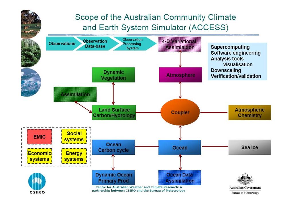
9 CAWCR Weather, Ocean and Environment ESM and Climate Science Weather and Environment Ocean Prediction Seasonal and Inter-annual Prediction Climate change Atmosphere & Land Observation and Assessment ACCESS Modelling, Assimilation Ocean Observation and Assessment

10
11


12 SOME RECENT ADVANCES / DATA IMPACT


13 OBSERVING SYSTEM EXPERIMENTS OBSERVING SYSTEM EXPERIMENTS WITH SATELLITE AND CONVENTIONAL DATA
14 a) c) N. Hemisphere 500 hpa AC Z 20N - 80N Waves Jan - 15 Feb 2003 N. Hemisphere 500 hpa AC Z 20N - 80N Waves Aug - 20 Sep 2003 Anomaly Correlation Forecast [day] Anomaly Correlation Forecast [day] b) Control NoSat NoCon S. Hemisphere 500 hpa AC Z 20S - 80S Waves Jan - 15 Feb 2003 d) Control NoSat NoCon S. Hemisphere 500 hpa AC Z 20S - 80S Waves Aug - 20 Sep 2003 Anomaly Correlation Forecast [day] Anomaly Correlation Forecast [day] Control NoSat NoCon Control NoSat NoCon Fig. 6. Anomaly correlation for days 0 to 7 for 500 hpa geopotential height in the zonal band for each Hemisphere and season. The control simulation is shown in blue, while the NoSat and NoCon denial experiments are shown in magenta and green, respectively.
15 Impact of Removing Satellite or Conventional Data on Hurricane Tracks in the Atlantic Basin Impact of Removing Satellite and Conventional Data on Hurricane Tracks in the East Pacific Average Track Error [NM] Control NOSAT NOCON Average Track Error [NM] Control NOSAT NOCON 0 12 hrs 24 hrs 36 hrs 48 hrs 72 hrs 96 hrs 0 12 hrs 24 hrs 36 hrs 48 hrs 72 hrs 96 hrs Forecast Time [hours] and Counts Forecast Time [hours] and Counts Fig. 7 The impact of removing satellite and in-situ data on hurricane track forecasts in the GFS during the period 15 August to 20 September Panels (a and b) show the average track error (NM) out to 96 hours for the control experiment and the NoSat and NoCon denials for the Atlantic and Pacific Basins, respectively.
16 OBSERVING SYSTEM EXPERIMENTS OBSERVING SYSTEM EXPERIMENT WITH FOUR SATELLITE DATA TYPES AND RAWINSONDE DATA

17 Fig. 8 The day 5 anomaly correlations for waves 1-20 for the (a and d) mid-latitudes, (b and e) polar regions and (c and f) tropics. Experiments shown for each term include, from left to right, the control simulation and denials of AMSU, HIRS, GEO winds, Rawinsondes and QuikSCAT. The 15 January to 15 February 2003 results are shown in the left column and the 15 August to 20 September results are shown in the right column. Note the different vertical scale in (c and f).

18 Fig. 9. The 15 January to 15 February 2003 day hpa geopotential height die-off curves for the control and five denial experiments. The Northern Hemisphere results are shown in the left panels and the Southern Hemisphere results are shown in the right panels.
, and the Eastern Pacific Basin results are shown in (b).")
19 Fig. 10. Average track error (NM) by forecast hour for the control simulation and experiments where AMSU, HIRS, GEO winds and QuikSCAT were denied. The Atlantic Basin results are shown in (a), and the Eastern Pacific Basin results are shown in (b). A small sample size in the number of hurricanes precludes presenting the 96 hour results in the Eastern Pacific Ocean.
20 MODIS Wind Assimilation into the NCEP Global Forecast System
21 Global Forecast System Background Operational SSI (3DVAR) version used Operational GFS T254L64 with reductions in resolution at 84 (T170L42) and 180 (T126L28) hours. 2.5hr cut off
 to simulate realistic data")
22 The Trial Winds assimilated only in second last analysis (later final analysis) to simulate realistic data availability.
23 Table 1: Satellite data used operationally within the GMAO/NCEP Global Forecast System HIRS sounder radiances AMSU-A sounder radiances AMSU-B sounder radiances GOES sounder radiances GOES 9,10,12, Meteosat atmospheric motion vectors GOES precipitation rate SSM/I ocean surface wind speeds SSM/I precipitation rates TRMM precipitation rates ERS-2 ocean surface wind vectors Quikscat ocean surface wind vectors AVHRR SST AVHRR vegetation fraction AVHRR surface type Multi-satellite snow cover Multi-satellite sea ice SBUV/2 ozone profile and total ozone
24 Table 1: Comparison of radiosonde wind estimates with Terra and Aqua based MODIS AMVs, colocated within 150km over high latitudes for the period 5 May 2005 to 10 January 2006 inclusive, where the AMV QI > [IR = 11µm based winds, WV = 6.7 µm based winds and MMVD = mean magnitude of vector difference (ms -1 )]. Type AQUA IR AQUA WV TERRA IR TERRA WV Low hPa No. of Obs. MMVD (ms -1 ) RMS Vec. Diff. (ms -1 ) N/A N/A N/A N/A N/A N/A Speed Bias (ms -1 ) N/A N/A Middle HPa No. of Obs. MMVD (ms -1 ) RMS Vec. Diff. (ms -1 ) Speed Bias (ms -1 ) High hPa No. of Obs. MMVD (ms -1 ) RMS Vec. Diff. (ms -1 ) Speed Bias (ms -1 )
25 Fig 1 (a) Distribution of levels of best fit compared to a collocated radiosonde profile for AMVs with pressure altitudes in the ranges 500 ± 50 hpa (Mid-level), 300 ± 50 hpa (High level) and, 850 ± 50 hpa (Low level). In all cases, the AMV QI is in the range 0.85 to 1.0.
26 Fig 1 (b) Distribution of levels of best fit compared to a collocated radiosonde profile for AMVs with pressure altitudes in the ranges 500 ± 50 hpa (mid-level), 300 ± 50 hpa (high level) and, 850 ± 50 hpa (low level). In all cases, the AMV EE is less than 5 m/s.
27 Fig. 2 (a) Error Correlation versus distance (using 10 km bins), determined by comparison with radiosonde winds, for MODIS WV Mid-level Vectors (Northern Hemisphere, May 2005 Jan 2006)
28 Table 2 (a) Parameters of the SOAR function (Equation 1) which best model the measured error correlations for the MODIS AMV types listed in the left column of the table. (QI = 0.65 to 1) Type R 00 R 0 L (km) Corr. Err. (ms -1 ) RMSD (ms - 1 ) Low IR Mid IR High IR Mid WV High WV
29 Table 2 (b) Parameter of the SOAR function (Equation 1) which best model the measured error correlations for the MODIS AMV types listed in the left column of the table. R 00 is assumed to be 0. (QI = 0.65 to 1) Type R 00 R 0 L (km) Corr. Err. (ms - 1 ) RMSD (ms -1 ) Low IR Mid IR High IR Mid WV High WV
30 1 N. Hem. 500 mb AC Z 60-90N Waves Aug - 23 Sep '04 Control Anomaly Correlation MODIS Forecast [days] Fig. 3. The 500 hpa geopotential height Anomaly Correlation for the Northern Hemisphere polar Region (60 N 90 N), for the GFS control and the GFS control including MODIS AMVs, for the period 10 August to 23 September 2004.
31 S. Hem. 500mb AC Z60S - 90S Waves Jan - 15 Feb '04 1 Anomaly Correlation Control MODIS Forecast [days] Fig. 5. The 500hPa geopotential height anomaly correlation for the Southern Hemisphere polar region (60 S 90 S), for the GFS control and the GFS control including MODIS AMVs, for the period 1 January to 15 February 2004.
32 2004 ATLANTIC BASIN AVERAGE HURRICANE TRACK ERRORS (NM) Cntrl Cntrl + MODIS Cases (#) 00-h 12-h 24-h 36-h 48-h 72-h 96-h 120-h Time Results compiled by Qing Fu Liu.
33 The Contribution of Locally Generated MTSat-1R Atmospheric Motion Vectors to Operational Meteorology in the Australian Region
34 MTSaT-1R IR1 AMVs Uses 3 images separated by 15 min. or 60 min. Uses H 2 0 intercept method for upper level AMVs (Schmetz et al., 1993) or Window Method. Uses cloud base assignment for lower level AMVs (Le Marshall et al. 1997) or Window Method Q.C. via EE, QI, ERR, RFF etc. No autoedit
35 Table 1. Real time schedule for MTSat-1R Atmospheric Motion Vectors at the Bureau of Meteorology. Sub-satellite image resolution, frequency and time of wind extraction and separations of the image triplets used for wind generation (/\T) are indicated. Wind Type Resolution Frequency-Times (UTC) Image Separation Real Time IR 4 km 6-hourly 00, 06, 12, minutes Real Time IR (hourly) 4 km Hourly 00, 01, 02, 03, 04, 05,...,23 1 hour

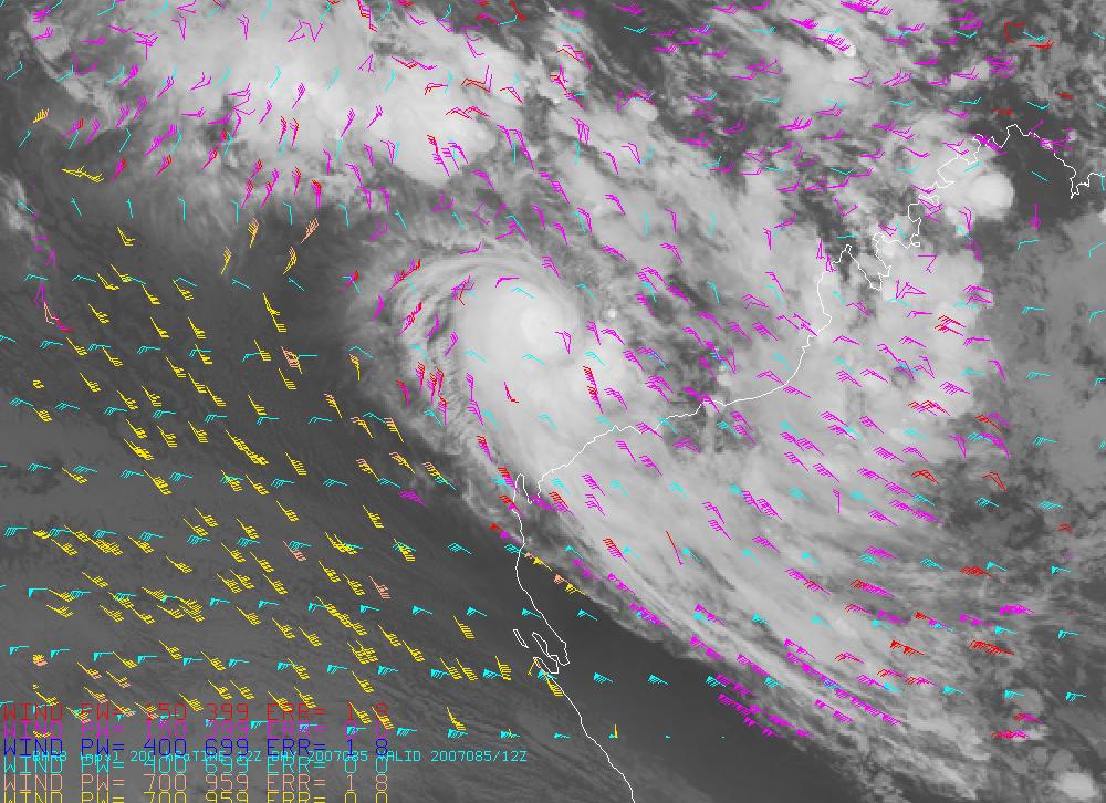
36 Fig. 1 (a) MTSat-1R AMVs generated around 12 UTC on 18 March Magenta denotes upper level tropospheric vectors, yellow, lower level tropospheric vectors
, yellow, lower level tropospheric")
37 Fig. 1 (b) A selection of MTSat-1R AMVs generated around 12 UTC on 18 March Magenta denotes upper level tropospheric vectors (above 500 hpa), yellow, lower level tropospheric vectors (below 500 hpa)
38

39
40

41
42 ERROR CHARACTERIZATION OF ATMOSPHERIC MOTION VECTORS QUALITY CONTROL
43 QUALITY CONTROL - Several components to quality control process ERR: Wind data accepted and errors assigned, in conjunction with several rejection criteria, including : * Correlation between images * U acceleration * V acceleration * U component deviation from guess * V component deviation from guess *.. QI EXPECTED ERROR
44 Quality Control (ERR) Considers Correlation between images U acceleration V acceleration U deviation from first guess V deviation from first guess
45 Quality Indicator (QI) Considers Direction consistency (pair) Speed consistency (pair) Vector consistency (pair) Spatial Consistency Forecast Consistency QI = w i.qv i / w i
46 Fig.3. Quality Indicator (QI) versus root mean square difference (RMSD) with radiosondes within 150 km for low level high-resolution visible image based AMVs for 28 April, 2000 to 29 April QI vs. RMSD - HRV low level RMSD (m/s) QI
47 EE - provides RMS Error (RMS) In current ops. currently estimated from: the five QI components, wind speed vertical wind shear, temperature shear, pressure level which are used as predictands for root mean square error Other statistical and physical calculation methods have been tested
48 EE ( RMS Error (RMS)) Can be (Is) inserted into current NESDIS BUFR (in test mode) using ( EE) = ( EE) QI *
49 Fig. 2 (a) Measured error (m/s) versus EE for high-level MTSAT-1R IR winds (13 March - 12 April 2007 Fig. 2 (b) Measured error (m/s) versus EE for lowlevel MTSAT-1R IR winds (13 March - 12 April 2007)
50 Table 2. Mean Magnitude of Vector Difference (MMVD) between MTSat-1R AMVs, forecast model first guess and radiosonde winds within 150 km for March 2007 Level No. of Obs First Guess MMVD (ms -1 ) AMV MMVD (ms -1 ) Low hpa Middle hpa High hpa
51
52 Correlated Error
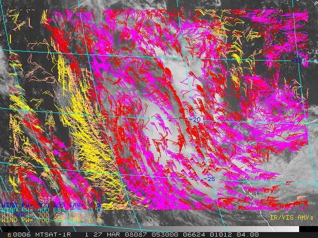
53 Correlated error The correlated error has been analysed for the Bureau produced MTSat-1R winds. The methodology was similar to that followed previously (Le Marshall et al., 2004). The correlated error and its spatial variation (length scale) were determined using the Second Order Auto Regressive (SOAR) function : R(r) = R 00 + R 0 (1 + r/l) exp (-r/l) (2) Where R(r) is the error correlation, R 0 and R 00 are the fitting parameters (greater than 0), L is the length scale and r is the separation of the correlates. The difference between AMV and radiosonde winds (error) has been separated into correlated and non-correlated parts. A typical variation of error correlation with distance for MTSat-1R IR1 AMVs is seen in Figure 3, while the parameters of the SOAR function which best fits the observations are contained in Table 3.
54 Fig. 3 Error correlation versus distance (100 km bins) for low-level MTSat-1R AMVs with EE < 6 and 8 m/s (March July 2007)
55 Table 3. Parameters of the SOAR function (Equation 2) which best model the measured error correlations for the MTSat-1R AMVs listed in the left column of the table. (February April, 2007) MTSat-1R IR1 AMVS Low R 00 High Low R 0 High L (km) Low High EE < EE <
56 MTSaT-1R DIRECT READOUT AMV GENERATION AND RT ASSIMILATION MTSaT-1R at 140 o E 0 o S from 2005 Ch2 (IR1) AMVs generated in RT RT trial 30 May - 15 June cases Trial used then operational RT LAPS levels RT trial 1 Sept. - 8 Aug cases Trial used now operational RT LAPS levels Local AMVs subsequently accepted for operational use.
57 RT MTSaT 1R IR1 AMVs Used 3 images separated by 15 min. or 60 min. Used H 2 0 intercept method for upper level AMVs (Ch3/4) (Schmetz et al., 1993) or Window Method. Used cloud base assignment for lower level AMVs (Ch4) (Le Marshall et al. 1997) or Window Method. Q.C. via EE, QI, ERR, RFF etc. No autoedit
58 30 May 15 June 2008 Used * Real Time Local Satellite Winds ~ 2 sets of IR1 quarter hourly motion vectors every six hours. * Operational Regional Forecast Model (L51)and Data Base ( Inc JMA AMVs) * Operational Regional Verification Grid
59 Table 4. Mean Magnitude of Vector Difference (MMVD) and Root Mean Square Difference (RMSD) between MTSat-1R AMVs, forecast model first guess winds and radiosonde winds for the period 30 May to 15 June 2007 Level Data Source Bias (ms -1 ) No. of Obs MMVD (ms -1 ) RMSVD (ms -1 ) High up to 150 km separation between radiosondes and AMVs AMVs First Guess Low - up to 150 km separation between radiosondes and AMVs AMVs First Guess Low up to 30 km separation between radiosondes and AMVs AMVs First Guess

60
61 Histogram 300 Number Gain
62 Table 5 (a) 24 hr forecast verification S1 Skill Scores for the May 2007 operational regional forecast system (L51 LAPS) and L51 LAPS with IR, 6-hourly image based AMVs for 30 May to 15 June 2007 (34 cases) LEVEL (LAPS) S1 (LAPS + MTSAT-1R AMVS) S1 MSLP 1000 hpa 900 hpa 850 hpa 500 hpa 300 hpa 250 hpa

63 1 September 8 October 2008 Used * Real Time Local Satellite Winds ~ 2 sets of IR1 quarter hourly motion vectors every six hours. * Operational Regional Forecast Model (L61)and Data Base ( Inc JMA AMVs) * Operational Regional Verification Grid
64 Table 5 (b) 24 hr forecast verification S1 Skill Scores for the next operational regional forecast system (L61 LAPS) and L61 LAPS with IR, 6-hourly image based AMVs for 1 September to 8 October 2007 (72 cases) LEVEL (LAPS) S1 (LAPS + MTSAT-1R AMVS) S1 MSLP 1000 hpa 900 hpa 850 hpa 500 hpa 300 hpa 250 hpa
65 Table 5 (a) 24 hr forecast verification S1 Skill Scores for the May 2007 operational regional forecast system (L51 LAPS) and L51 LAPS with IR, 6-hourly image based AMVs for 30 May to 15 June 2007 (34 cases) Table 5 (b) 24 hr forecast verification S1 Skill Scores for the next operational regional forecast system (L61 LAPS) and L61 LAPS with IR, 6-hourly image based AMVs for 1 September to 8 October 2007 (72 cases) LEVEL (LAPS) S1 (LAPS + MTSAT-1R AMVS) S1 LEVEL (LAPS) S1 (LAPS + MTSAT- 1R AMVS) S1 MSLP 1000 hpa 900 hpa 850 hpa 500 hpa 300 hpa 250 hpa MSLP 1000 hpa 900 hpa 850 hpa 500 hpa 300 hpa 250 hpa
66 The Transition from MTSaT 1R HIRID Format to HRIT Format 02:30 UTC 12 March 2008
67 HRIT IR1 AMV/RAOB Comparison: 24 January 20 February, 2008 v1 15min. Wind Level LOW ERR=0,EE<3.5 High ERR=0,QI=.6-1. Wind Type AMV Background AMV Background RAOB/AMV Sep No of Vectors Bias m/s MMVD RMS VD m/s HRIT IR1 AMV/RAOB Comparison: 24 January 20 February, 2008 v2 15min. Wind Level LOW ERR=0,EE<3.5 High QI=.6-1. Wind Type AMV Background AMV Background RAOB/AMV Sep No of Vectors BIAS m/s MMVD m/s RMS VD m/s
68 HRIT AMVs Pre-implementation Operational Test Operational TLAPS S1 Scores versus Operational TLAPS plus HRIT IR1 Atmospheric Motion Vectors (AMVs)-Feb 21 March-10 (17 Cases) MSLP 1000 hpa 850hPa 500 hpa 300 hpa 250 hpa Ops Ops. + HRIT
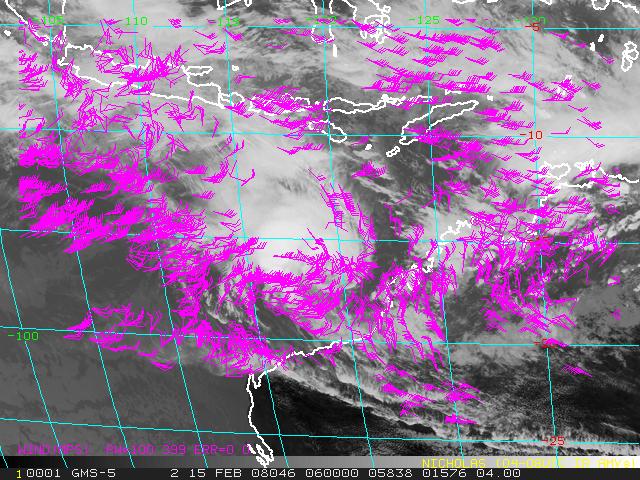
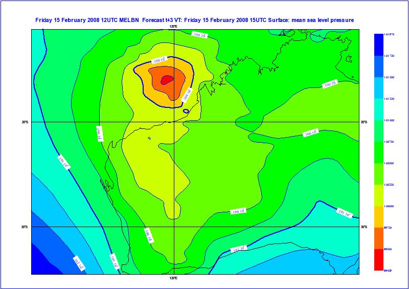
69 The Future ACCESS UKUM Global and Regional Impact Studies Use of Continuous Data- Hourly AMVs in 4D-VAR eg.tc Nicholas Western Australian region February 2008
70 The Future

71 The Future
72 The Future
73
74
75
76
77
78
79
80

81
82 The Future Cloud Height Assignment and Verification LBF, A-Train Error Characterization Model Clouds Moisture tracking / 4D-VAR..

83 The business of looking down is looking up
84 Discussion and Conclusions Both the geo-stationery and polar orbiting satellitebased AMVs have been shown to make a significant contribution globally to operational analysis and forecasting. MODIS AMVs have been shown to make a positive contribution in polar, mid-latitude and tropical regions. MTSaT-1R AMVs have been generated at the Australian BoM and have been shown to provide significant benefits in the Australian region. The successful application of MTSaT-1R AMVs has been facilitated by the careful use of quality-control parameters such as the ERR, EE and QI. Assimilatiom studies with UKUM based ACCESS model underway.
85
HIGH SPATIAL AND TEMPORAL RESOLUTION ATMOSPHERIC MOTION VECTORS GENERATION, ERROR CHARACTERIZATION AND ASSIMILATION
 HIGH SPATIAL AND TEMPORAL RESOLUTION ATMOSPHERIC MOTION VECTORS GENERATION, ERROR CHARACTERIZATION AND ASSIMILATION John Le Marshall Director, JCSDA 2004-2007 CAWCR 2007-2010 John Le Marshall 1,2, Rolf
Operational Generation And Assimilation Of Himawari-8. Atmospheric Motion Vectors
 Operational Generation And Assimilation Of Himawari-8 Atmospheric Motion Vectors John Le Marshall 1, David Howard 1, Xingbao Wang 1, Yi Xiao 1, Jim Jung 2, Jaime Daniels 4,Steve Wanzong 2, Joan Fernon
A two-season impact study of the Navy s WindSat surface wind retrievals in the NCEP global data assimilation system
 A two-season impact study of the Navy s WindSat surface wind retrievals in the NCEP global data assimilation system Li Bi James Jung John Le Marshall 16 April 2008 Outline WindSat overview and working
Impact of METOP ASCAT Ocean Surface Winds in the NCEP GDAS/GFS and NRL NAVDAS
 Impact of METOP ASCAT Ocean Surface Winds in the NCEP GDAS/GFS and NRL NAVDAS COAMPS @ Li Bi 1,2 James Jung 3,4 Michael Morgan 5 John F. Le Marshall 6 Nancy Baker 2 Dave Santek 3 1 University Corporation
The Use of Hyperspectral Infrared Radiances In Numerical Weather Prediction
 The Use of Hyperspectral Infrared Radiances In Numerical Weather Prediction J. Le Marshall 1, J. Jung 1, J. Derber 1, T. Zapotocny 2, W. L. Smith 3, D. Zhou 4, R. Treadon 1, S. Lord 1, M. Goldberg 1 and
AMVs in the ECMWF system:
 AMVs in the ECMWF system: Overview of the recent operational and research activities Kirsti Salonen and Niels Bormann Slide 1 AMV sample coverage: monitored GOES-15 GOES-13 MET-10 MET-7 MTSAT-2 NOAA-15
HIGH SPATIAL AND TEMPORAL RESOLUTION ATMOSPHERIC MOTION VECTORS GENERATION, ERROR CHARACTERIZATION AND ASSIMILATION
 HIGH SPATIAL AND TEMPORAL RESOLUTION ATMOSPHERIC MOTION VECTORS GENERATION, ERROR CHARACTERIZATION AND ASSIMILATION John Le Marshall 1,2, Rolf Seecamp 3, Yi Xiao 1, J. Jung 4,Terry Skinner 3, Peter Steinle
Operational Generation and Assimilation of Himawari-8 Atmospheric Motion Vectors
 Proceedings for the 13 th International Winds Workshop 27 June - 1 July 2016, Monterey, California, USA Operational Generation and Assimilation of Himawari-8 Atmospheric Motion Vectors John Le Marshall
Advances in weather modelling
 Advances in weather modelling www.cawcr.gov.au Robert Fawcett - speaking on behalf of CAWCR Earth-System Modelling and CAWCR Weather and Environmental Prediction May 2013 The Centre for Australian Weather
Analysis of an Observing System Experiment for the Joint Polar Satellite System
 Analysis of an Observing System Experiment for the Joint Polar Satellite System S. Lord, George Gayno 1 and Fanglin Yang 1 24 November 2015 1 I. M. Systems Group at NCEP/EMC 1 Outline The Joint Polar Satellite
OSSE to infer the impact of Arctic AMVs extracted from highly elliptical orbit imagery
 OSSE to infer the impact of Arctic AMVs extracted from highly elliptical orbit imagery L. Garand 1 Y. Rochon 1, S. Heilliette 1, J. Feng 1, A.P. Trishchenko 2 1 Environment Canada, 2 Canada Center for
Assimilation of Himawari-8 Atmospheric Motion Vectors into the Numerical Weather Prediction Systems of Japan Meteorological Agency
 Assimilation of Himawari-8 Atmospheric Motion Vectors into the Numerical Weather Prediction Systems of Japan Meteorological Agency Koji Yamashita Japan Meteorological Agency kobo.yamashita@met.kishou.go.jp,
TOWARDS IMPROVED HEIGHT ASSIGNMENT AND QUALITY CONTROL OF AMVS IN MET OFFICE NWP
 Proceedings for the 13 th International Winds Workshop 27 June - 1 July 2016, Monterey, California, USA TOWARDS IMPROVED HEIGHT ASSIGNMENT AND QUALITY CONTROL OF AMVS IN MET OFFICE NWP James Cotton, Mary
Assimilation of Geostationary WV Radiances within the 4DVAR at ECMWF
 Assimilation of Geostationary WV Radiances within the 4DVAR at ECMWF Christina Köpken Graeme Kelly, Jean-Noël Thépaut ECMWF EUMETSAT Fellowship ITSC-XII Lorne, Australia, 27 February - 5 March 2002 Assimilation
JMA s atmospheric motion vectors
 Prepared by JMA Agenda Item: WG II/6 Discussed in WG II JMA s atmospheric motion vectors This paper reports on the recent status of JMA's Atmospheric Motion Vectors (AMVs) from MTSAT-2 and MTSAT-1R, and
Use of satellite winds at Deutscher Wetterdienst (DWD)
") Use of satellite winds at Deutscher Wetterdienst (DWD) Alexander Cress Deutscher Wetterdienst, Frankfurter Strasse 135, 63067 Offenbach am Main, Germany alexander.cress@dwd.de Ø Introduction Ø Atmospheric
Use of satellite winds at Deutscher Wetterdienst (DWD) Alexander Cress Deutscher Wetterdienst, Frankfurter Strasse 135, 63067 Offenbach am Main, Germany alexander.cress@dwd.de Ø Introduction Ø Atmospheric
Current Status of COMS AMV in NMSC/KMA
 Current Status of COMS AMV in NMSC/KMA Eunha Sohn, Sung-Rae Chung, Jong-Seo Park Satellite Analysis Division, NMSC/KMA soneh0431@korea.kr COMS AMV of KMA/NMSC has been produced hourly since April 1, 2011.
AMVs in the operational ECMWF system
 AMVs in the operational ECMWF system Kirsti Salonen and Niels Bormann Slide 1 AMV sample coverage: monitored GOES-15 GOES-13 MET-10 MET-7 MTSAT-2 NOAA-15 NOAA-18 NOAA-19 FY-2D FY-2E AQUA TERRA METOP-A
Satellite Assimilation Activities for the NRL Atmospheric Variational Data Assimilation (NAVDAS) and NAVDAS- AR (Accelerated Representer) Systems
 and NAVDAS- AR (Accelerated Representer) Systems") Satellite Assimilation Activities for the NRL Atmospheric Variational Data Assimilation (NAVDAS) and NAVDAS- AR (Accelerated Representer) Systems Marine Meteorology Division, NRL Monterey Nancy Baker,
Satellite Assimilation Activities for the NRL Atmospheric Variational Data Assimilation (NAVDAS) and NAVDAS- AR (Accelerated Representer) Systems Marine Meteorology Division, NRL Monterey Nancy Baker,
RECENT ADVANCES IN THE GENERATION AND ASSIMILATION OF HIGH SPATIAL AND TEMPORAL RESOLUTION SATELLITE WINDS
 RECENT ADVANCES IN THE GENERATION AND ASSIMILATION OF HIGH SPATIAL AND TEMPORAL RESOLUTION SATELLITE WINDS J. Le Marshall 1, N. Pescod 1, R. Seecamp 1, A. Rea 2, C. Tingwell 1, G. Ellis 2 and Hao Shi 3
AMVs in the ECMWF system:
 AMVs in the ECMWF system: Highlights of the operational and research activities Kirsti Salonen and Niels Bormann Slide 1 Number of used AMVs Look back: how the use of AMVs has evolved NOAA-15,-16,-18,-19
VALIDATION OF DUAL-MODE METOP AMVS
 VALIDATION OF DUAL-MODE METOP AMVS Ákos Horváth 1, Régis Borde 2, and Hartwig Deneke 1 1 Leibniz Institute for Tropospheric Research, Permoserstrasse 15, Leipzig, Germany 2 EUMETSAT, Eumetsat Allee 1,
Recent Advances in the Processing, Targeting and Data Assimilation Applications of Satellite-Derived Atmospheric Motion Vectors (AMVs)
") Recent Advances in the Processing, Targeting and Data Assimilation Applications of Satellite-Derived Atmospheric Motion Vectors (AMVs) Howard Berger and Chris Velden Cooperative Institute for Meteorological
Recent Advances in the Processing, Targeting and Data Assimilation Applications of Satellite-Derived Atmospheric Motion Vectors (AMVs) Howard Berger and Chris Velden Cooperative Institute for Meteorological
JMA s ATMOSPHERIC MOTION VECTORS In response to Action 40.22
 5 July 2013 Prepared by JMA Agenda Item: II/6 Discussed in WG II JMA s ATMOSPHERIC MOTION VECTORS In response to Action 40.22 This paper reports on the recent status of JMA's AMVs from MTSAT-2 and MTSAT-1R,
THE BENEFITS OF INCREASED USE OF THE INFORMATION CONTENT OF HYPERSPECTRAL
 THE BENEFITS OF INCREASED USE OF THE INFORMATION CONTENT OF HYPERSPECTRAL J4.4 OBSERVATIONS IN NUMERICAL WEATHER PREDICTION J. Le Marshall (, 2 ) * and J. Jung (3,4) Centre for Australian Weather and Climate
INTRODUCTION OF THE RECURSIVE FILTER FUNCTION IN MSG MPEF ENVIRONMENT
 INTRODUCTION OF THE RECURSIVE FILTER FUNCTION IN MSG MPEF ENVIRONMENT Gregory Dew EUMETSAT Abstract EUMETSAT currently uses its own Quality Index (QI) scheme applied to wind vectors derived from the Meteosat-8
Upgraded usage of MODIS-derived polar winds in the JMA operational global 4D-Var assimilation system
 1 Upgraded usage of MODIS-derived polar winds in the JMA operational global 4D-Var assimilation system Koji Yamashita Japan Meteorological Agency Kobo.yamashita@met.kishou.go.jp Background Objectives 2
Marine Meteorology Division, Naval Research Laboratory, Monterey, CA. Tellus Applied Sciences, Inc.
 Nancy Baker 1, Rolf Langland 1, Pat Pauley 1, Liang Xu 1 Dagmar Merkova 2,3 and Ron Gelaro 2 Chris Velden 4 1 Marine Meteorology Division, Naval Research Laboratory, Monterey, CA 2 Global Modeling and
SATELLITE DATA IMPACT STUDIES AT ECMWF
 SATELLITE DATA IMPACT STUDIES AT ECMWF Outline of talk 1. Impact of early sounders (past and in reanalysis) 2. Problems with satellite retrievals 3. Direct use of radiances 4. Impact experiments with ERA
Interpretation of Polar-orbiting Satellite Observations. Atmospheric Instrumentation
 Interpretation of Polar-orbiting Satellite Observations Outline Polar-Orbiting Observations: Review of Polar-Orbiting Satellite Systems Overview of Currently Active Satellites / Sensors Overview of Sensor
Observing System Impact Studies in ACCESS
 Observing System Impact Studies in ACCESS www.cawcr.gov.au Chris Tingwell, Peter Steinle, John le Marshall, Elaine Miles, Yi Xiao, Rolf Seecamp, Jin Lee, Susan Rennie, Xingbao Wang, Justin Peter, Alan
Shorter contribution
 Aust. Met. Mag. 57 (2008) 249-254 Shorter contribution Using cloudy AIRS fields of view in numerical weather prediction J. Le Marshall 1, 2, J. Jung 2, 3, M. Goldberg 4, C. Barnet 4, W. Wolf 4, J. Derber
Using Clear and Cloudy AIRS Data in Numerical Weather Prediction
 Using Clear and Cloudy AIRS Data in Numerical Weather Prediction J. Le Marshall (, 2), J. Jung (,3), M. Goldberg (4), L-P Riishojgaard, C. Barnet (4), W. Wolf (4), J. Derber (5,), R. Treadon (5,) and S.
Assimilation of GOES Hourly and Meteosat winds in the NCEP Global Forecast System (GFS)
") Assimilation of GOES Hourly and Meteosat winds in the NCEP Global Forecast System (GFS) Xiujuan Su, Jaime Daniels, John Derber, Yangrong Lin, Andy Bailey, Wayne Bresky, Hongming Qi JCSDA 11th Workshop
Assimilation of GOES Hourly and Meteosat winds in the NCEP Global Forecast System (GFS) Xiujuan Su, Jaime Daniels, John Derber, Yangrong Lin, Andy Bailey, Wayne Bresky, Hongming Qi JCSDA 11th Workshop
Operational Use of Scatterometer Winds at JMA
 Operational Use of Scatterometer Winds at JMA Masaya Takahashi Numerical Prediction Division, Japan Meteorological Agency (JMA) 10 th International Winds Workshop, Tokyo, 26 February 2010 JMA Outline JMA
Current status and plans of JMA operational wind product
 Current status and plans of JMA operational wind product Kazuki Shimoji Japan Meteorological Agency / Meteorological Satellite Center 3-235, Nakakiyoto, Kiyose, Tokyo, Japan Abstract The Meteorological
Satellite-Derived Winds in the U.S. Navy s Global NWP System: Usage and Data Impacts in the Tropics
 Satellite-Derived Winds in the U.S. Navy s Global NWP System: Usage and Data Impacts in the Tropics Patricia Pauley 1, Rolf Langland 1, Rebecca Stone 2, and Nancy Baker 1 1 Naval Research Laboratory, Monterey,
JCSDA EXPERIMENTS IN THE USE OF RADIANCES IN NUMERICAL WEATHER PREDICTION
 JCSDA EXPERIMENTS IN THE USE OF RADIANCES IN NUMERICAL WEATHER PREDICTION J. Le Marshall, J. Jung, T. Zapotocny, W. L. Smith, D. Zhou, J. Derber, R. Treadon, S. Lord, M. Goldberg and W. Wolf JCSDA Partners
Use of DFS to estimate observation impact in NWP. Comparison of observation impact derived from OSEs and DFS. Cristina Lupu
 Use of DFS to estimate observation impact in NWP. Comparison of observation impact derived from OSEs and DFS. Cristina Lupu ECMWF, Reading, UK Collaboration: Pierre Gauthier (UQAM), Stéphane Laroche (Environment
STATUS OF JAPANESE METEOROLOGICAL SATELLITES AND RECENT ACTIVITIES OF MSC
 STATUS OF JAPANESE METEOROLOGICAL SATELLITES AND RECENT ACTIVITIES OF MSC Daisaku Uesawa Meteorological Satellite Center, Japan Meteorological Agency Abstract MTSAT-1R is the current operational Japanese
Improvements to the NCEP Global and Regional Data Assimilation Systems
 Improvements to the NCEP Global and Regional Data Assimilation Systems Stephen J. Lord Director NCEP Environmental Modeling Center EMC Staff NCEP: where America s climate, weather, and ocean services begin
ACCOUNTING FOR THE SITUATION-DEPENDENCE OF THE AMV OBSERVATION ERROR IN THE ECMWF SYSTEM
 ACCOUNTING FOR THE SITUATION-DEPENDENCE OF THE AMV OBSERVATION ERROR IN THE ECMWF SYSTEM Kirsti Salonen and Niels Bormann ECMWF, Shinfield Park, Reading RG2 9AX, United Kingdom Abstract This article reports
Feature-tracked 3D Winds from Satellite Sounders: Derivation and Impact in Global Models
 Feature-tracked 3D Winds from Satellite Sounders: Derivation and Impact in Global Models David Santek, Anne-Sophie Daloz 1, Samantha Tushaus 1, Marek Rogal 1, Will McCarty 2 1 Space Science and Engineering
NUMERICAL EXPERIMENTS USING CLOUD MOTION WINDS AT ECMWF GRAEME KELLY. ECMWF, Shinfield Park, Reading ABSTRACT
 NUMERICAL EXPERIMENTS USING CLOUD MOTION WINDS AT ECMWF GRAEME KELLY ECMWF, Shinfield Park, Reading ABSTRACT Recent monitoring of cloud motion winds (SATOBs) at ECMWF has shown an improvement in quality.
IMPACT EXPERIMENTS ON GMAO DATA ASSIMILATION AND FORECAST SYSTEMS WITH MODIS WINDS DURING MOWSAP. Lars Peter Riishojgaard and Yanqiu Zhu
 IMPACT EXPERIMENTS ON GMAO DATA ASSIMILATION AND FORECAST SYSTEMS WITH MODIS WINDS DURING MOWSAP Lars Peter Riishojgaard and Yanqiu Zhu Global Modeling and Assimilation Office, NASA/GSFC, Greenbelt, Maryland
Masahiro Kazumori, Takashi Kadowaki Numerical Prediction Division Japan Meteorological Agency
 Development of an all-sky assimilation of microwave imager and sounder radiances for the Japan Meteorological Agency global numerical weather prediction system Masahiro Kazumori, Takashi Kadowaki Numerical
THE USE OF SATELLITE OBSERVATIONS IN NWP
 THE USE OF SATELLITE OBSERVATIONS IN NWP The impact of satellite measurements on NWP began in the early 70s with the operational use of global satellite cloud imagery. Nowadays the impact is from active
Ninth Workshop on Meteorological Operational Systems. Timeliness and Impact of Observations in the CMC Global NWP system
 Ninth Workshop on Meteorological Operational Systems ECMWF, Reading, United Kingdom 10 14 November 2003 Timeliness and Impact of Observations in the CMC Global NWP system Réal Sarrazin, Yulia Zaitseva
Improving Tropical Cyclone Forecasts by Assimilating Microwave Sounder Cloud-Screened Radiances and GPM precipitation measurements
 Improving Tropical Cyclone Forecasts by Assimilating Microwave Sounder Cloud-Screened Radiances and GPM precipitation measurements Hyojin Han a, Jun Li a, Mitch Goldberg b, Pei Wang a,c, Jinlong Li a,
Feature-tracked 3D Winds from Satellite Sounders: Derivation and Impact in Global Models
 Feature-tracked 3D Winds from Satellite Sounders: Derivation and Impact in Global Models David Santek 1, A.-S. Daloz 1, S. Tushaus 1, M. Rogal 1, W. McCarty 2 1 Space Science and Engineering Center/University
Data Impact Studies in the CMC Global NWP system
 Third WMO Workshop on the Impact of Various Observing Systems on WP Alpbach, Austria 9 12 March 2004 Data Impact Studies in the CMC Global WP system Gilles Verner, Réal Sarrazin and Yulia Zaitseva Canadian
P4.23 INTRODUCING THE GOES IMAGER CLEAR-SKY BRIGHTNESS TEMPERATURE (CSBT) PRODUCT
 PRODUCT") P4.23 INTRODUCING THE GOES IMAGER CLEAR-SKY BRIGHTNESS TEMPERATURE (CSBT) PRODUCT Anthony J. Schreiner Cooperative Institute for Meteorological Satellite Studies (CIMSS) University of Wisconsin-Madison
P4.23 INTRODUCING THE GOES IMAGER CLEAR-SKY BRIGHTNESS TEMPERATURE (CSBT) PRODUCT Anthony J. Schreiner Cooperative Institute for Meteorological Satellite Studies (CIMSS) University of Wisconsin-Madison
Improving the use of satellite winds at the Deutscher Wetterdienst (DWD)
") Improving the use of satellite winds at the Deutscher Wetterdienst (DWD) Alexander Cress Deutscher Wetterdienst, Frankfurter Strasse 135, 63067 Offenbach am Main, Germany alexander.cress@dwd.de Ø Introduction
Improving the use of satellite winds at the Deutscher Wetterdienst (DWD) Alexander Cress Deutscher Wetterdienst, Frankfurter Strasse 135, 63067 Offenbach am Main, Germany alexander.cress@dwd.de Ø Introduction
The Impact of Satellite Atmospheric Motion Vectors in the U.S. Navy Global Data Assimilation System NWP Results
 The Impact of Satellite Atmospheric Motion Vectors in the U.S. Navy Global Data Assimilation System NWP Results Nancy L. Baker 1, Rolf Langland 1, Patricia M. Pauley 1, Liang Xu 1, Dagmar Merkova 2,3,
Impact of assimilating the VIIRS-based CrIS cloudcleared radiances on hurricane forecasts
 Impact of assimilating the VIIRS-based CrIS cloudcleared radiances on hurricane forecasts Jun Li @, Pei Wang @, Jinlong Li @, Zhenglong Li @, Jung-Rim Lee &, Agnes Lim @, Timothy J. Schmit #, and Mitch
Extending the use of surface-sensitive microwave channels in the ECMWF system
 Extending the use of surface-sensitive microwave channels in the ECMWF system Enza Di Tomaso and Niels Bormann European Centre for Medium-range Weather Forecasts Shinfield Park, Reading, RG2 9AX, United
MODIS- and AVHRR-derived Polar Winds Experiments using the NCEP GDAS/GFS NA10NES
 Proposed Work MODIS- and AVHRR-derived Polar Winds Experiments using the NCEP GDAS/GFS NA10NES4400011 Year 3 First-half Progress Report June 2012 through November 2012 28 December 2012 David Santek, PI
OBSERVING SYSTEM EXPERIMENTS ON ATOVS ORBIT CONSTELLATIONS
 OBSERVING SYSTEM EXPERIMENTS ON ATOVS ORBIT CONSTELLATIONS Enza Di Tomaso and Niels Bormann European Centre for Medium-range Weather Forecasts Shinfield Park, Reading, RG2 9AX, United Kingdom Abstract
11 days (00, 12 UTC) 132 hours (06, 18 UTC) One unperturbed control forecast and 26 perturbed ensemble members. --
 132 hours (06, 18 UTC) One unperturbed control forecast and 26 perturbed ensemble members. --") APPENDIX 2.2.6. CHARACTERISTICS OF GLOBAL EPS 1. Ensemble system Ensemble (version) Global EPS (GEPS1701) Date of implementation 19 January 2017 2. EPS configuration Model (version) Global Spectral Model
APPENDIX 2.2.6. CHARACTERISTICS OF GLOBAL EPS 1. Ensemble system Ensemble (version) Global EPS (GEPS1701) Date of implementation 19 January 2017 2. EPS configuration Model (version) Global Spectral Model
Scatterometer Wind Assimilation at the Met Office
 Scatterometer Wind Assimilation at the Met Office James Cotton International Ocean Vector Winds Science Team (IOVWST) meeting, Brest, June 2014 Outline Assimilation status Global updates: Metop-B and spatial
Recent Data Assimilation Activities at Environment Canada
 Recent Data Assimilation Activities at Environment Canada Major upgrade to global and regional deterministic prediction systems (now in parallel run) Sea ice data assimilation Mark Buehner Data Assimilation
THE ESTIMATION AND UTILITY OF HIGH SPATIAL AND TEMPORAL RESOLUTION WINDS DERIVED FROM GMS-5 OBSERVATIONS
 THE ESTIMATION AND UTILITY OF HIGH SPATIAL AND TEMPORAL RESOLUTION WINDS DERIVED FROM GMS-5 OBSERVATIONS J.F. Le Marshall 1, N.R. Pescod 1 and C. Spinoso 2 Bureau of Meteorology Research Centre GPO Box
Satellite-derived Wind, Cloud, and Surface Products at Direct Broadcast Sites in the Antarctic and Arctic
 Satellite-derived Wind, Cloud, and Surface Products at Direct Broadcast Sites in the Antarctic and Arctic William Straka III +, Jeff Key*, Dave Santek +, Matthew Lazzara #, Liam Gumley +, Kathy Strabala
IMPACT STUDIES OF AMVS AND SCATTEROMETER WINDS IN JMA GLOBAL OPERATIONAL NWP SYSTEM
 IMPACT STUDIES OF AMVS AND SCATTEROMETER WINDS IN JMA GLOBAL OPERATIONAL NWP SYSTEM Koji Yamashita Japan Meteorological Agency / Numerical Prediction Division 1-3-4, Otemachi, Chiyoda-ku, Tokyo 100-8122,
STATUS AND DEVELOPMENT OF SATELLITE WIND MONITORING BY THE NWP SAF
 STATUS AND DEVELOPMENT OF SATELLITE WIND MONITORING BY THE NWP SAF Mary Forsythe (1), Antonio Garcia-Mendez (2), Howard Berger (1,3), Bryan Conway (4), Sarah Watkin (1) (1) Met Office, Fitzroy Road, Exeter,
The role of GPS-RO at ECMWF" ! COSMIC Data Users Workshop!! 30 September 2014! !!! ECMWF
 The role of GPS-RO at ECMWF"!!!! COSMIC Data Users Workshop!! 30 September 2014! ECMWF WE ARE Intergovernmental organisation! 34 Member and Cooperating European states! 270 staff at ECMWF, in Reading,
AIRS Related Advances at the JCSDA -ITCS14-
 AIRS Related Advances at the JCSDA -ITCS14- Overview JCSDA Background Data Base The Assimilation System Results to Date. Imminent Activity Summary Joint Center for Satellite Data Assimilation PARTNERS
Enhanced Use of Radiance Data in NCEP Data Assimilation Systems
 Enhanced Use of Radiance Data in NCEP Data Assimilation Systems John C. Derber*, Paul VanDelst #, XiuJuan Su &, Xu Li &, Kozo Okamoto % and Russ Treadon* Introduction *NOAA/NWS/NCEP/EMC # CIMSS/UW-Madison
Satellite Radiance Data Assimilation at the Met Office
 Satellite Radiance Data Assimilation at the Met Office Ed Pavelin, Stephen English, Brett Candy, Fiona Hilton Outline Summary of satellite data used in the Met Office NWP system Processing and quality
AN OBSERVING SYSTEM EXPERIMENT OF MTSAT RAPID SCAN AMV USING JMA MESO-SCALE OPERATIONAL NWP SYSTEM
 AN OBSERVING SYSTEM EXPERIMENT OF MTSAT RAPID SCAN AMV USING JMA MESO-SCALE OPERATIONAL NWP SYSTEM Koji Yamashita Japan Meteorological Agency / Numerical Prediction Division 1-3-4, Otemachi, Chiyoda-ku,
Some NOAA Products that Address PSTG Satellite Observing Requirements. Jeff Key NOAA/NESDIS Madison, Wisconsin USA
 Some NOAA Products that Address PSTG Satellite Observing Requirements Jeff Key NOAA/NESDIS Madison, Wisconsin USA WMO Polar Space Task Group, 4 th meeting, Greenbelt, 30 September 2014 Relevant Missions
Operational Use of Scatterometer Winds in the JMA Data Assimilation System
 Operational Use of Scatterometer Winds in the Data Assimilation System Masaya Takahashi Numerical Prediction Division, Japan Meteorological Agency () International Ocean Vector Winds Science Team Meeting,
The assimilation of AMSU and SSM/I brightness temperatures in clear skies at the Meteorological Service of Canada
 The assimilation of AMSU and SSM/I brightness temperatures in clear skies at the Meteorological Service of Canada Abstract David Anselmo and Godelieve Deblonde Meteorological Service of Canada, Dorval,
Improved analyses and forecasts with AIRS retrievals using the Local Ensemble Transform Kalman Filter
 Improved analyses and forecasts with AIRS retrievals using the Local Ensemble Transform Kalman Filter Hong Li, Junjie Liu, and Elana Fertig E. Kalnay I. Szunyogh, E. J. Kostelich Weather and Chaos Group
Generation and Initial Evaluation of a 27-Year Satellite-Derived Wind Data Set for the Polar Regions NNX09AJ39G. Final Report Ending November 2011
 Generation and Initial Evaluation of a 27-Year Satellite-Derived Wind Data Set for the Polar Regions NNX09AJ39G Final Report Ending November 2011 David Santek, PI Space Science and Engineering Center University
The satellite winds in the operational NWP system at Météo-France
 The satellite winds in the operational NWP system at Météo-France Christophe Payan CNRM UMR 3589, Météo-France/CNRS 13th International Winds Workshop, Monterey, USA, 27 June 1st July 2016 Outline Operational
GOES-16 AMV data evaluation and algorithm assessment
 GOES-16 AMV data evaluation and algorithm assessment Katie Lean and Niels Bormann IWW14, Jeju Island, South Korea, 23-27 th April 2018 katie.lean@ecmwf.int ECMWF May 3, 2018 Outline Introduction Changes
Impact of Satellite Atmospheric Motion Vectors in the GMAO GEOS 5 Global Data Assimilation System
 Impact of Satellite Atmospheric Motion Vectors in the GMAO GEOS 5 Global Data Assimilation System update of results presented at the 5 th WMO Workshop on the Impact of Various Observing Systems on NWP,
RETRIEVAL AND APPLICATIONS OF ATMOSPHERIC MOTION VECTORS USING INSAT-3D/3DR DATA : ISRO STATUS
 RETRIEVAL AND APPLICATIONS OF ATMOSPHERIC MOTION VECTORS USING INSAT-3D/3DR DATA : ISRO STATUS Sanjib K Deb, D K Sankhala, C M Kishtawal Atmospheric and Oceanic Sciences Group Space Applications Centre
Introduction to Reanalysis and JRA-55
 TCC Training Seminar (29 JAN. 2018) Introduction to Reanalysis and JRA-55 Masashi HARADA Climate Prediction Division, Japan Meteorological Agency Outline 1. Introduction to Reanalysis Basic dataset for
Report on CIMSS Participation in the Utility of GOES-R Instruments for Hurricane Data Assimilation and Forecasting
 Report on CIMSS Participation in the Utility of GOES-R Instruments for Hurricane Data Assimilation and Forecasting Award Number: NA10NES4400010 Award Period: 06/01/2010-05/31/2014 Program Office: NESDIS
Introduction. Recent changes in the use of AMV observations. AMVs over land. AMV impact study. Use of Scatterometer data (Ascat, Oceansat-2)
") Recent progress in using satellite winds at the German Weather Service Alexander Cress, Heinz Werner Bitzer German Weather Service, Offenbach am Main, Germany, email: Alexander.Cress@dwd.de Introduction
Recent progress in using satellite winds at the German Weather Service Alexander Cress, Heinz Werner Bitzer German Weather Service, Offenbach am Main, Germany, email: Alexander.Cress@dwd.de Introduction
Assessment of new AMV data in the ECMWF system: First year report
 EUMETSAT/ECMWF Fellowship Programme Research Report No. 43 Assessment of new AMV data in the ECMWF system: First year report K. Lean, N. Bormann and K. Salonen January 2017 Series: EUMETSAT/ECMWF Fellowship
Impact Evaluation of New Radiance data, Reduced Thinning and Higher Analysis Resolution in the GEM Global Deterministic Prediction System
 Impact Evaluation of New Radiance data, Reduced Thinning and Higher Analysis Resolution in the GEM Global Deterministic Prediction ITSC-17, Monterey, California Presenter: G. Deblonde*1, Co-authors: A.
THE POLAR WIND PRODUCT SUITE
 THE POLAR WIND PRODUCT SUITE Jeffrey Key 1, David Santek 2, Christopher Velden 2, Jaime Daniels 1, Richard Dworak 2 1 Center for Satellite Applications and Research, NOAA/NESDIS 2 Cooperative Institute
The ECMWF coupled data assimilation system
 The ECMWF coupled data assimilation system Patrick Laloyaux Acknowledgments: Magdalena Balmaseda, Kristian Mogensen, Peter Janssen, Dick Dee August 21, 214 Patrick Laloyaux (ECMWF) CERA August 21, 214
Height correction of atmospheric motion vectors (AMVs) using lidar observations
 using lidar observations") Height correction of atmospheric motion vectors (AMVs) using lidar observations Kathrin Folger and Martin Weissmann Hans-Ertel-Centre for Weather Research, Data Assimilation Branch Ludwig-Maximilians-Universität
Height correction of atmospheric motion vectors (AMVs) using lidar observations Kathrin Folger and Martin Weissmann Hans-Ertel-Centre for Weather Research, Data Assimilation Branch Ludwig-Maximilians-Universität
The JRA-55 Reanalysis: quality control and reprocessing of observational data
 The JRA-55 Reanalysis: quality control and reprocessing of observational data Kazutoshi Onogi On behalf of JRA group Japan Meteorological Agency 29 October 2014 EASCOF 1 1. Introduction 1. Introduction
WHAT CAN WE LEARN FROM THE NWP SAF ATMOSPHERIC MOTION VECTOR MONITORING?
 WHAT CAN WE LEARN FROM THE NWP SAF ATMOSPHERIC MOTION VECTOR MONITORING? Mary Forsythe 1, James Cotton 1, Antonio Garcia-Mendez 2, Bryan Conway 1 (1) Met Office, FitzRoy Road, Exeter, EX1 3PB, United Kingdom
RECENT UPGRADES OF AND ACTIVITIES FOR ATMOSPHERIC MOTION VECTORS AT JMA/MSC
 1 th International Winds Workshop, Tokyo, Japan, - ruary 1 RECENT UPGRADES OF AND ACTIVITIES FOR ATMOSPHERIC MOTION VECTORS AT JMA/MSC Ryo OYAMA Meteorological Satellite Center of Japan Meteorological
Satellite data assimilation for Numerical Weather Prediction (NWP)
") Satellite data assimilation for Numerical Weather Prediction (NWP Niels Bormann European Centre for Medium-range Weather Forecasts (ECMWF (with contributions from Tony McNally, Slide 1 Jean-Noël Thépaut,
Satellite data assimilation for Numerical Weather Prediction (NWP Niels Bormann European Centre for Medium-range Weather Forecasts (ECMWF (with contributions from Tony McNally, Slide 1 Jean-Noël Thépaut,
NWP SAF AMV monitoring: the 8th Analysis Report (AR8)
") Document NWPSAF-MO-TR-035 Version 1.0 08/03/18 NWP SAF AMV monitoring: the 8th Analysis Report (AR8) Francis Warrick, James Cotton Met Office, UK NWP SAF AMV monitoring: the 8th Analysis Report (AR8) Francis
Document NWPSAF-MO-TR-035 Version 1.0 08/03/18 NWP SAF AMV monitoring: the 8th Analysis Report (AR8) Francis Warrick, James Cotton Met Office, UK NWP SAF AMV monitoring: the 8th Analysis Report (AR8) Francis
Introducing Atmospheric Motion Vectors Derived from the GOES-16 Advanced Baseline Imager (ABI)
") Introducing Atmospheric Motion Vectors Derived from the GOES-16 Advanced Baseline Imager (ABI) Jaime Daniels NOAA/NESDIS, Center for Satellite Applications and Research Wayne Bresky, Andrew Bailey, Americo
Introducing Atmospheric Motion Vectors Derived from the GOES-16 Advanced Baseline Imager (ABI) Jaime Daniels NOAA/NESDIS, Center for Satellite Applications and Research Wayne Bresky, Andrew Bailey, Americo
Use of ATOVS raw radiances in the operational assimilation system at Météo-France
 Use of ATOVS raw radiances in the operational assimilation system at Météo-France Élisabeth Gérard, Florence Rabier, Delphine Lacroix Météo-France, Toulouse, France Zahra Sahlaoui Maroc-Météo, Casablanca,
ASSESSING THE QUALITY OF HISTORICAL AVHRR POLAR WIND HEIGHT ASSIGNMENT
 ASSESSING THE QUALITY OF HISTORICAL AVHRR POLAR WIND HEIGHT ASSIGNMENT Richard Dworak + and Jeff Key* + Cooperative Institute for Meteorological Satellite Studies (CIMSS), University of Wisconsin Madison,
Use of reprocessed AMVs in the ECMWF Interim Re-analysis
 Use of reprocessed AMVs in the ECMWF Interim Re-analysis Claire Delsol EUMETSAT Fellow Dick Dee and Sakari Uppala (Re-Analysis), IoannisMallas(Data), Niels Bormann, Jean-Noël Thépaut, and Peter Slide Bauer
NOAA Report. Hal Bloom Mitch Goldberg NOAA/NESDIS
 NOAA Report Hal Bloom Mitch Goldberg NOAA/NESDIS Summary of Major Events at NESDIS (of interest to ITSC) NOAA/NASA addressing NPOESS Climate Sensors Letter of agreement signed with JAXA on GCOM interagency
AN UPDATE ON UW-CIMSS SATELLITE-DERIVED WIND DEVELOPMENTS
 AN UPDATE ON UW-CIMSS SATELLITE-DERIVED WIND DEVELOPMENTS Christopher Velden, Steve Wanzong and Paul Menzel University of Wisconsin - Cooperative Institute for Meteorological Satellite Studies 1225 West
TC intensity estimation using Satellite data at JMA
 SECOND INTERNATIONAL WORKSHOP ON SATELLITE ANALYSIS OF TROPICAL CYCLONES (IWSATC-II) TC intensity estimation using Satellite data at JMA Topics: 1) Estimation of TC central pressure using Microwave Sounder
An Overview of Atmospheric Analyses and Reanalyses for Climate
 An Overview of Atmospheric Analyses and Reanalyses for Climate Kevin E. Trenberth NCAR Boulder CO Analysis Data Assimilation merges observations & model predictions to provide a superior state estimate.