Development of a System for Quantitatively Analyzing Volcanic Clouds
|
|
|
- Candace Gibson
- 6 years ago
- Views:
Transcription


 Marco")


1 Development of a System for Quantitatively Analyzing Volcanic Clouds Michael Pavolonis (NOAA/NESDIS/STAR) Justin Sieglaff and John Cintineo (UW-CIMSS) Marco Fulle nd IUGG-WMO Workshop on Ash Dispersal Forecast and Civil Aviation November 18-20,
2 Outline Description of satellite-derived volcanic ash data set Summary of results from 2008 Kasatochi eruption
3 Summary of Techniques End products: ash probability, ash top height, mass loading, effective particle radius, volcanic cloud alerts, cloud vertical growth rate anomalies, volcanic thermal anomalies Techniques: probabilistic cloud object based ash detection, optimal estimation retrieval of ash cloud properties (ash height, mass loading, and effective radius), multi-sensor cloud tracking to improve ash detection and cloud property retrieval Ash detection does not rely on robust split-window signature and is designed to emulate a skilled human analyst (high probability of detection, very low false alarm rate) Value added applications: plume medial axis transformation and polygon fitting


4 GEO LEO Making Full Use of the Space-based Observing System for Volcanic Cloud Monitoring NOAA and MetOp AVHRR Terra and Aqua MODIS SNPP-VIIRS GOES MTSAT-(1r and 2) Met-(8,9,10) SEVIRI
5
6
7
8

9

10 Volcanic cloud and volcanic thermal anomaly alerts are distributed via and SMS. Many eruptions around the world have been detected by the NOAA system since it came online in May 2013 (some of those eruptions went undetected using current operational tools).
11

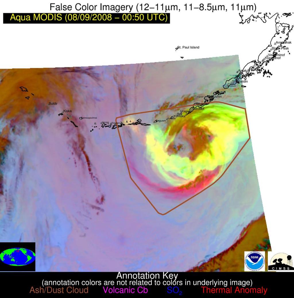
12 The cloud is very absorbing (darker) in the visible relative to meteorological clouds, so the dominant particulate composition is ash The textual appearance is indicative of spatial variability in cloud top height
13


14 The location of the largest mass loadings are consistent with the corresponding true color image (darker brown colors are indicative of larger visible ash optical depths)

15 Aircraft encounter Kasatochi ash was found in the engine of a 757 that encountered a volcanic cloud in Northern British Columbia, Canada (Guffanti et al., 2010)
16

17
18 The limited sensitivity to large optical depths in the IR likely causes the first total mass value to be underestimated Total mass and area time series
19 The temporal evolution of the 25 th, 50 th, and 75 th percentiles of mass loading, effective radius, and ash cloud height also exhibit expected behavior Mass loading (25 th, 50 th, and 75 th percentiles), effective particle radius (25 th, 50 th, and 75 th percentiles), and IQR of ash cloud height decreasing with time


20 Primary particulate composition: Sulphate or ash? Krotkov et al., 2010

21 Primary particulate composition: Sulphate or ash? Karagulian et al., 2010

22 Primary particulate composition: Sulphate or ash? Non-spherical particle signature Spherical particle signature

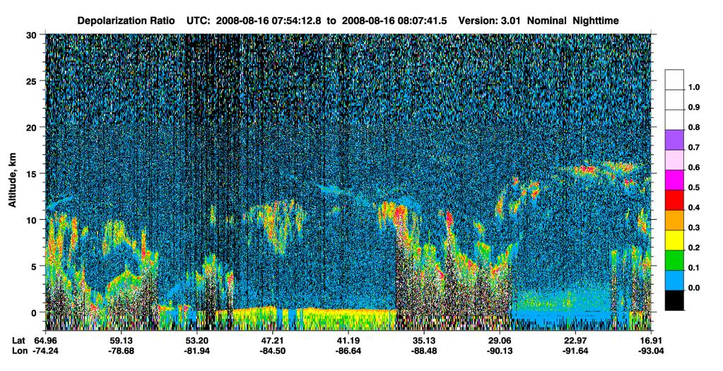
23 Kasatochi layers near Madison, WI August 16, 2013 Kasatochi layers near Madison, WI


24 Kasatochi layers near Madison, WI August 28, 2013 Kasatochi layers near Madison, WI
25 Kasatochi Conclusions MODIS and GOES both showed spatially and temporally consistent volcanic ash signatures in the NIR and IR (channels without significant SO 2 absorption) well after August 10, 2008 Particulate matter collected from a commercial jet aircraft flying in a region with significant amounts of SO 2 was consistent with Kasatochi ash (Guffanti et al., 2010), the NOAA algorithm detected ash in this same region Small (r < 2 μm) particles of ash would take about 2 to 9 weeks to fall (under gravity only) from 12 to 10 km (ICAO manual) Small amounts of ash were collected by research aircraft in Europe (Martinsson et al., 2009) The University of Wisconsin HSRL clearly showed a stratospheric cloud dominated by non-spherical particles prior to August 20, 2008 The CALIOP depolarization ratios, especially for optically thin clouds, must be interpreted with care The NOAA data set indicates that the stratospheric ash cloud (composed mainly of small particles) may have dispersed over a very large area consistent with the location of the SO 2 cloud The location of the ash cloud relative to a mid-latitude cyclone played an important role in the dispersion (portions of the cloud may have been impacted by tropopause folds caused by jet stream dynamics)
Current capabilities and limitations of satellite monitoring and modeling forecasting of volcanic clouds: and example of Eyjafjallaj
 Current capabilities and limitations of satellite monitoring and modeling forecasting of volcanic clouds: and example of Eyjafjallaj fjallajökull eruption (pronounced EYE-a-fyat fyat-la-jo-kotl) N. Krotkov
SACS & SACS2 an overview and recent developments
 SACS & SACS2 an overview and recent developments L. Clarisse (1), N. Theys (2), H. Brenot (2), J. van Gent (2), R. van der A (4), P. Valks (5), M. Van Roozendael (2), D. Hurtmans (1), P.-F. Coheur (1),
Inter-comparison MTSAT-2 & Himawari-8
 Inter-comparison MTSAT-2 & Himawari-8 WMO Volcanic Ash Advisory Centre Best Practice Workshop 2017 Tokyo Volcanic Ash Advisory Centre Japan Meteorological Agency Outline Introduction Method Case study
Satellite observation of atmospheric dust
 Satellite observation of atmospheric dust Taichu Y. Tanaka Meteorological Research Institute, Japan Meteorological Agency 11 April 2017, SDS WAS: Dust observation and modeling @WMO, Geneva Dust observations
The WMO Satellite-derived Volcanic Ash Intercomparison Activity - Capabilities and Challenges for Operational Applications
 Marco Fulle - www.stromboli.net The WMO Satellite-derived Volcanic Ash Intercomparison Activity - Capabilities and Challenges for Operational Applications Michael Pavolonis NOAA/NESDIS 1 WMO Intercomparison
IVATF/4-WP/11 Revision 1 07/06/12. International WORKING PAPER IVATF TASK. (Presented SUMMARY 1.1. (5 pages)
") International Civil Aviation Organization WORKING PAPER Revision 1 07/06/12 INTERNATIONAL VOLCANIC ASH TASK FORCE (IVATF) FOURTH MEETING Montréal, 13 to 15 June 2012 Agenda Item 2: Report of the science
International Civil Aviation Organization WORKING PAPER Revision 1 07/06/12 INTERNATIONAL VOLCANIC ASH TASK FORCE (IVATF) FOURTH MEETING Montréal, 13 to 15 June 2012 Agenda Item 2: Report of the science
Dispersion modelling and warnings for volcanic ash in the Australian Region
 Dispersion modelling and warnings for volcanic ash in the Australian Region R Potts, R Dare, E Jansons, C Lucas, A Tupper, M Zidikheri The Centre for Australian Weather and Climate Research A partnership
AMVs in the operational ECMWF system
 AMVs in the operational ECMWF system Kirsti Salonen and Niels Bormann Slide 1 AMV sample coverage: monitored GOES-15 GOES-13 MET-10 MET-7 MTSAT-2 NOAA-15 NOAA-18 NOAA-19 FY-2D FY-2E AQUA TERRA METOP-A
Comparison of methodologies for SO 2 and Ash identification using observations from IASI
 Comparison of methodologies for SO 2 and Ash identification using observations from IASI Maria Athanassiadou, Peter N Francis, Stephan Havemann, Elisa Carboni EGU, 15 Apr., 2015 This talk is about... IASI
Development of volcanic ash product for the next-generation Japanese Geostationary Meteorological Satellite Himawari-8
 Development of volcanic ash product for the next-generation Japanese Geostationary Meteorological Satellite Himawari-8 Hiroaki Tsuchiyama 1, Yukio Kurihara 1, Kazuhiko Masuda 2 (1) Japan Meteorological
Satellite-based Convection Nowcasting and Aviation Turbulence Applications
 Satellite-based Convection Nowcasting and Aviation Turbulence Applications Kristopher Bedka Cooperative Institute for Meteorological Satellite Studies (CIMSS), University of Wisconsin-Madison In collaboration
AMVs in the ECMWF system:
 AMVs in the ECMWF system: Overview of the recent operational and research activities Kirsti Salonen and Niels Bormann Slide 1 AMV sample coverage: monitored GOES-15 GOES-13 MET-10 MET-7 MTSAT-2 NOAA-15
DIFFERING REGIONAL CAPABILITIES IN SATELLITE-BASED VOLCANIC ASH CLOUD DETECTION
 Prepared by NOAA Agenda Item: II/8 Discussed in WGII DIFFERING REGIONAL CAPABILITIES IN SATELLITE-BASED VOLCANIC ASH CLOUD DETECTION The GOES-R AWG is responsible for the developing the algorithms that
PHEOS - Weather, Climate, Air Quality
 Aerosol & cloud remote sensing over the Arctic : perspectives for the PHEMOS and meteorological imager payloads on the PCW mission Norm O Neill, Auromeet Saha, U. de Sherbrooke Chris E. Sioris, Jack McConnell,
Satellite techniques for timely detection and near real-time monitoring of volcanic ash clouds for aviation safety
 Satellite techniques for timely detection and near real-time monitoring of volcanic ash clouds for aviation safety N. Pergola A. Falconieri F. Marchese V. Tramutoli Consiglio Nazionale delle Ricerche Istituto
SATELLITE SIGNATURES ASSOCIATED WITH SIGNIFICANT CONVECTIVELY-INDUCED TURBULENCE EVENTS
 SATELLITE SIGNATURES ASSOCIATED WITH SIGNIFICANT CONVECTIVELY-INDUCED TURBULENCE EVENTS Kristopher Bedka 1, Wayne Feltz 1, John Mecikalski 2, Robert Sharman 3, Annelise Lenz 1, and Jordan Gerth 1 1 Cooperative
HYSPLIT volcanic ash dispersion modeling R&D, NOAA NWS NCEP operations, and transfer to operations
 HYSPLIT volcanic ash dispersion modeling R&D, NOAA NWS NCEP operations, and transfer to operations Barbara Stunder 1, Alice Crawford 1,2, Tianfeng Chai 1,2, Michael Pavolonis 3 1 NOAA OAR Air Resources
CLAVR-x is the Clouds from AVHRR Extended Processing System. Responsible for AVHRR cloud products and other products at various times.
 CLAVR-x in CSPP Andrew Heidinger, NOAA/NESDIS/STAR, Madison WI Nick Bearson, SSEC, Madison, WI Denis Botambekov, CIMSS, Madison, WI Andi Walther, CIMSS, Madison, WI William Straka III, CIMSS, Madison,
Volcanic Sulphur Dioxide
 Volcanic Sulphur Dioxide Overview Background & context Claire Witham VAAC SO 2 forecast demonstration Dov Bensimon Rolls Royce work on SO2 Rory Clarkson New capabilities to remotely sense SO2 - Marcel
Recommendation proposed: CGMS-39 WGII to take note.
 Prepared by EUMETSAT Agenda Item: G.II/8 Discussed in WGII EUM REPORT ON CAPABILITIES AND PLANS TO SUPPORT VOLCANIC ASH MONITORING In response to CGMS action WGII 38.31: CGMS satellite operators are invited
Feature-tracked 3D Winds from Satellite Sounders: Derivation and Impact in Global Models
 Feature-tracked 3D Winds from Satellite Sounders: Derivation and Impact in Global Models David Santek 1, A.-S. Daloz 1, S. Tushaus 1, M. Rogal 1, W. McCarty 2 1 Space Science and Engineering Center/University
An Overview of the UW Hyperspectral Retrieval System for AIRS, IASI and CrIS
 An Overview of the UW Hyperspectral Retrieval System for AIRS, IASI and CrIS Nadia Smith a, Elisabeth Weisz b and William L. Smith Cooperative Institute for Meteorological Satellite Studies (CIMSS) Space
Your Source for Global Aviation Forecasts
 Your Source for Global Aviation Forecasts (831) 238-5054 100 Sky Park Drive Monterey, CA 93940 Weather4Cast.com Live Weather Data Feeds Weather4Cast.com provides Live Aviation Weather Data Feeds formatted
JMA volcanic ash Test bed. Japan Meteorological Agency Meteorological Satellite Center Hidehiko MURATA
 JMA volcanic ash Test bed Japan Meteorological Agency Meteorological Satellite Center Hidehiko MURATA ET SUP 8, WMO HQ, Geneva, 14 17 April 2014 Background User requirements (from a slide SNWC 1/PP2 by
The Advanced Satellite Aviation-weather Products (ASAP) initiative at the University of Wisconsin - CIMSS
 initiative at the University of Wisconsin - CIMSS") P3.3 The Advanced Satellite Aviation-weather Products (ASAP) initiative at the University of Wisconsin - CIMSS Wayne F. Feltz*, John R. Mecikalski #, John J. Murray +, David B. Johnson -, Kristopher Bedka*,
P3.3 The Advanced Satellite Aviation-weather Products (ASAP) initiative at the University of Wisconsin - CIMSS Wayne F. Feltz*, John R. Mecikalski #, John J. Murray +, David B. Johnson -, Kristopher Bedka*,
Improvements on Near Real Time Detection of Volcanic Ash Emissions for Emergency Monitoring with Limited Satellite Bands
 ANNALS OF GEOPHYSICS, Fast Track 2, 2014; doi: 10.4401/ag-6598 Improvements on Near Real Time Detection of Volcanic Ash Emissions for Emergency Monitoring with Limited Satellite Bands TORGE STEENSEN 1
Meteorological Priorities in Support of a Volcanic Ash Strategy ( )
") Meteorological Priorities in Support of a Volcanic Ash Strategy (2010-11) Ian Lisk, Met Office Volcanic Ash Coordination Programme Manager; EUMETNET VA coordinator; WMO CAeM vice-president. Introduction
Meteorological Priorities in Support of a Volcanic Ash Strategy (2010-11) Ian Lisk, Met Office Volcanic Ash Coordination Programme Manager; EUMETNET VA coordinator; WMO CAeM vice-president. Introduction
30 Years of HIRS Cloud Observations
 30 Years of HIRS Cloud Observations W. Paul Menzel a, Erik Olson a, Utkan Kolat a, Robert Holz a, Bryan Baum a, Andrew Heidinger b, Michael Pavolonis b, Don Wylie a, Darren Jackson c, Brent Maddux a, and
Sensitivity Study of the MODIS Cloud Top Property
 Sensitivity Study of the MODIS Cloud Top Property Algorithm to CO 2 Spectral Response Functions Hong Zhang a*, Richard Frey a and Paul Menzel b a Cooperative Institute for Meteorological Satellite Studies,
NESDIS Polar (Region) Products and Plans. Jeff Key NOAA/NESDIS Madison, Wisconsin USA
 Products and Plans. Jeff Key NOAA/NESDIS Madison, Wisconsin USA") NESDIS Polar (Region) Products and Plans Jeff Key NOAA/NESDIS Madison, Wisconsin USA WMO Polar Space Task Group, 2 nd meeting, Geneva, 12 14 June 2012 Relevant Missions and Products GOES R ABI Fractional
NESDIS Polar (Region) Products and Plans Jeff Key NOAA/NESDIS Madison, Wisconsin USA WMO Polar Space Task Group, 2 nd meeting, Geneva, 12 14 June 2012 Relevant Missions and Products GOES R ABI Fractional
Generation and Initial Evaluation of a 27-Year Satellite-Derived Wind Data Set for the Polar Regions NNX09AJ39G. Final Report Ending November 2011
 Generation and Initial Evaluation of a 27-Year Satellite-Derived Wind Data Set for the Polar Regions NNX09AJ39G Final Report Ending November 2011 David Santek, PI Space Science and Engineering Center University
DERIVING ATMOSPHERIC MOTION VECTORS FROM AIRS MOISTURE RETRIEVAL DATA
 DERIVING ATMOSPHERIC MOTION VECTORS FROM AIRS MOISTURE RETRIEVAL DATA David Santek 1, Sharon Nebuda 1, Christopher Velden 1, Jeff Key 2, Dave Stettner 1 1 Cooperative Institute for Meteorological Satellite
Satellite-Based Detection of Fog and Very Low Stratus
 Satellite-Based Detection of Fog and Very Low Stratus A High-Latitude Case Study Centred on the Helsinki Testbed Experiment J. Cermak 1, J. Kotro 2, O. Hyvärinen 2, V. Nietosvaara 2, J. Bendix 1 1: Laboratory
Interpretation of Polar-orbiting Satellite Observations. Atmospheric Instrumentation
 Interpretation of Polar-orbiting Satellite Observations Outline Polar-Orbiting Observations: Review of Polar-Orbiting Satellite Systems Overview of Currently Active Satellites / Sensors Overview of Sensor
Country Report - Singapore
 Country Report - Singapore The 5th Meeting of the Coordinating Group Vladivostok city, Russky Island, Russia Far Eastern Federal University of the RA II WIGOS Satellite Project 21 October 2017 Outline
Some NOAA Products that Address PSTG Satellite Observing Requirements. Jeff Key NOAA/NESDIS Madison, Wisconsin USA
 Some NOAA Products that Address PSTG Satellite Observing Requirements Jeff Key NOAA/NESDIS Madison, Wisconsin USA WMO Polar Space Task Group, 4 th meeting, Greenbelt, 30 September 2014 Relevant Missions
WMO Aeronautical Meteorology Scientific Conference 2017
 Session 1 Science underpinning meteorological observations, forecasts, advisories and warnings 1.5 Atmospheric aerosols, volcanic ash research Development of an ensemble-based volcanic ash dispersion model
Single footprint sounding, surface emissivity and cloud property retrievals from hyperspectral infrared radiances under all sky conditions
 Single footprint sounding, surface emissivity and cloud property retrievals from hyperspectral infrared radiances under all sky conditions Jun Li @, Elisabeth Weisz @, Jinlong Li @, Allen Huang @, Chian-Yi
RGB Products: an easy and practical way to display multispectral satellite data (in combination with derived products)
") RGB Products: an easy and practical way to display multispectral satellite data (in combination with derived products) Dr. Jochen Kerkmann Training Officer EUMETSAT Multi-channel GEO satellites today Him-08
RGB Products: an easy and practical way to display multispectral satellite data (in combination with derived products) Dr. Jochen Kerkmann Training Officer EUMETSAT Multi-channel GEO satellites today Him-08
University of Bristol - Explore Bristol Research
 Prata, F., Woodhouse, M. J., Huppert, H. E., Prata, A., Thordarson, TH., & Carn, S. A. (2017). Atmospheric processes affecting the separation of volcanic ash and SO2 in volcanic eruptions: Inferences from
Direct Readout at the Meteorological Service of Canada
 Direct Readout at the Meteorological Service of Canada CSPP Users Meeting 2015 Darmstadt, Germany April 14-16, 2015 David Bradley Manager, Earth Observation and Geomatics Meteorological Service of Canada
Using McIDAS-V for Satellite-Based Thunderstorm Research and Product Development
 Using McIDAS-V for Satellite-Based Thunderstorm Research and Product Development Kristopher Bedka UW-Madison, SSEC/CIMSS In Collaboration With: Tom Rink, Jessica Staude, Tom Whittaker, Wayne Feltz, and
The Impacts on Air Traffic of Volcanic Ash from the Okmok and Kasatochi Eruptions During the Summer of 2008
 The Impacts on Air Traffic of Volcanic Ash from the Okmok and Kasatochi Eruptions During the Summer of 2008 Lauren A. Hudnall Christopher Newport University, Newport News, VA A.J. Krueger University of
NOAA s National Weather Service VAAC Anchorage. Don Moore
 NOAA s National Weather Service VAAC Anchorage Don Moore VAAC Best Practices Workshop May 2015 Volcanic Eruptions Volcanic Eruptions Volcanic Eruptions VAAC Anchorage and Alaska Aviation Weather Unit (AAWU)
Advantageous GOES IR results for ash mapping at high latitudes: Cleveland eruptions 2001
 GEOPHYSICAL RESEARCH LETTERS, VOL. 32, L02305, doi:10.1029/2004gl021651, 2005 Advantageous GOES IR results for ash mapping at high latitudes: Cleveland eruptions 2001 Yingxin Gu, 1 William I. Rose, 1 David
Introduction of the Hyperspectral Environmental Suite (HES) on GOES-R and beyond
 on GOES-R and beyond") Introduction of the Hyperspectral Environmental Suite (HES) on GOES-R and beyond Timothy J. Schmit SaTellite Applications and Research (STAR) Advanced Satellite Products Team (ASPT) Presented by Jun Li
Introduction of the Hyperspectral Environmental Suite (HES) on GOES-R and beyond Timothy J. Schmit SaTellite Applications and Research (STAR) Advanced Satellite Products Team (ASPT) Presented by Jun Li
Title Slide: AWIPS screengrab of AVHRR data fog product, cloud products, and POES sounding locations.
 Title Slide: AWIPS screengrab of AVHRR data fog product, cloud products, and POES sounding locations. Slide 2: 3 frames: Global tracks for NOAA19 (frame 1); NOAA-19 tracks over CONUS (frame 2); NOAA-19
Satellite-Derived Aviation Hazard Products at the University of Wisconsin: Convection, Turbulence, Volcanic Ash, and Winds
 5.08 Satellite-Derived Aviation Hazard Products at the University of Wisconsin: Convection, Turbulence, Volcanic Ash, and Winds Wayne F. Feltz*, John R. Mecikalski #, John J. Murray +, David B. Johnson
Explosive volcanic eruptions in the North Pacific: Interactions between the Alaska Volcano Observatory and Volcanic Ash Advisory Centers
 Explosive volcanic eruptions in the North Pacific: Interactions between the Alaska Volcano Observatory and Volcanic Ash Advisory Centers David Schneider U.S. Geological Survey Alaska Volcano Observatory
NOAA Report. Hal Bloom Mitch Goldberg NOAA/NESDIS
 NOAA Report Hal Bloom Mitch Goldberg NOAA/NESDIS Summary of Major Events at NESDIS (of interest to ITSC) NOAA/NASA addressing NPOESS Climate Sensors Letter of agreement signed with JAXA on GCOM interagency
Washington Volcanic Ash Advisory Center
 How a Volcanic Ash Advisory and a Dispersion Forecast is Prepared: Jamie Kibler Washington VAAC Operations Manger/Meteorologist October 25, 2011 ICAO Seminar on Volcanic Ash Products and Communications
Usage of McIDAS V with GOES R AWG products
 McIDAS User Group Meeting, October 25-27, 2010, Madison, WI Usage of McIDAS V with GOES R AWG products William Straka III UW/CIMSS Madison, Wisconsin, USA With help from Tom Rink (CIMSS/), Tom Achtor (CIMSS/),
On the Satellite Determination of Multilayered Multiphase Cloud Properties. Science Systems and Applications, Inc., Hampton, Virginia 2
 JP1.10 On the Satellite Determination of Multilayered Multiphase Cloud Properties Fu-Lung Chang 1 *, Patrick Minnis 2, Sunny Sun-Mack 1, Louis Nguyen 1, Yan Chen 2 1 Science Systems and Applications, Inc.,
Feature-tracked 3D Winds from Satellite Sounders: Derivation and Impact in Global Models
 Feature-tracked 3D Winds from Satellite Sounders: Derivation and Impact in Global Models David Santek, Anne-Sophie Daloz 1, Samantha Tushaus 1, Marek Rogal 1, Will McCarty 2 1 Space Science and Engineering
On the assimilation of hyperspectral infrared sounder radiances in cloudy skies
 On the assimilation of hyperspectral infrared sounder radiances in cloudy skies Jun Li 1, Pei Wang 1, Zhenglong Li 1, Jinlong Li 1 and Mitchell D. Goldberg 2 1 Cooperative Institute for Meteorological
Jun Mitch Goldberg %, Pei Timothy J. Schmit &, Jinlong Zhenglong and Agnes
 Progress on the assimilation of advanced IR sounder radiances in cloudy skies Jun Li @, Mitch Goldberg %, Pei Wang @#, Timothy J. Schmit &, Jinlong Li @, Zhenglong Li @, and Agnes Lim @ @CIMSS, University
Implementation Guidance of Aeronautical Meteorological Observer Competency Standards
 Implementation Guidance of Aeronautical Meteorological Observer Competency Standards The following guidance is supplementary to the AMP competency Standards endorsed by Cg-16 in Geneva in May 2011. Please
Volcanic Ash Monitoring Claus Zehner, ESA
 Volcanic Ash Monitoring Claus Zehner, ESA Slide: 1 Support to Aviation Control Service A global Alert (and Analysis demonstration only) system for volcanic Ash and SO2 emissions using satellite measurements
P3.13 GLOBAL COMPOSITE OF VOLCANIC ASH SPLIT ` WINDOW GEOSTATIONARY SATELLITE IMAGES
 P3.13 GLOBAL COMPOSITE OF VOLCANIC ASH SPLIT ` WINDOW GEOSTATIONARY SATELLITE IMAGES Frederick R. Mosher * Embry-Riddle Aeronautical University Daytona Beach, FL 1.0 Introduction Volcanic ash is exceptionally
VALIDATION OF DUAL-MODE METOP AMVS
 VALIDATION OF DUAL-MODE METOP AMVS Ákos Horváth 1, Régis Borde 2, and Hartwig Deneke 1 1 Leibniz Institute for Tropospheric Research, Permoserstrasse 15, Leipzig, Germany 2 EUMETSAT, Eumetsat Allee 1,
Instrumentation planned for MetOp-SG
 Instrumentation planned for MetOp-SG Bill Bell Satellite Radiance Assimilation Group Met Office Crown copyright Met Office Outline Background - the MetOp-SG programme The MetOp-SG instruments Summary Acknowledgements:
A new perspective on aerosol direct radiative effects in South Atlantic and Southern Africa
 A new perspective on aerosol direct radiative effects in South Atlantic and Southern Africa Ian Chang and Sundar A. Christopher Department of Atmospheric Science University of Alabama in Huntsville, U.S.A.
INTERNATIONAL AIRWAYS VOLCANO WATCH OPERATIONS GROUP (IAVWOPSG)
") International Civil Aviation Organization IAVWOPSG/8-WP/39 13/1/14 WORKING PAPER INTERNATIONAL AIRWAYS VOLCANO WATCH OPERATIONS GROUP (IAVWOPSG) EIGHTH MEETING Melbourne, Australia, 17 to 20 February 2014
International Civil Aviation Organization IAVWOPSG/8-WP/39 13/1/14 WORKING PAPER INTERNATIONAL AIRWAYS VOLCANO WATCH OPERATIONS GROUP (IAVWOPSG) EIGHTH MEETING Melbourne, Australia, 17 to 20 February 2014
Flight north of Iceland...near Eyjafjallajokull
 Flight north of Iceland...near Eyjafjallajokull Presented by Cpt. Heinz Frühwirth, IFALPA Prepared by Cpt. Klaus Sievers, German ALPA 27 June 2011 This presentation concerns a flight from Europe to the
AMVs in the ECMWF system:
 AMVs in the ECMWF system: Highlights of the operational and research activities Kirsti Salonen and Niels Bormann Slide 1 Number of used AMVs Look back: how the use of AMVs has evolved NOAA-15,-16,-18,-19
Near real-time monitoring of the April-May 2010 Eyjafjöll s ash cloud
 Near real-time monitoring of the April-May 2010 Eyjafjöll s ash cloud Labazuy P. and the HotVolc Team Observatoire de Physique du Globe de Clermont-Ferrand, CNRS, Université Blaise Pascal 13th International
Current Status of COMS AMV in NMSC/KMA
 Current Status of COMS AMV in NMSC/KMA Eunha Sohn, Sung-Rae Chung, Jong-Seo Park Satellite Analysis Division, NMSC/KMA soneh0431@korea.kr COMS AMV of KMA/NMSC has been produced hourly since April 1, 2011.
OSSE to infer the impact of Arctic AMVs extracted from highly elliptical orbit imagery
 OSSE to infer the impact of Arctic AMVs extracted from highly elliptical orbit imagery L. Garand 1 Y. Rochon 1, S. Heilliette 1, J. Feng 1, A.P. Trishchenko 2 1 Environment Canada, 2 Canada Center for
P3.24 EVALUATION OF MODERATE-RESOLUTION IMAGING SPECTRORADIOMETER (MODIS) SHORTWAVE INFRARED BANDS FOR OPTIMUM NIGHTTIME FOG DETECTION
 SHORTWAVE INFRARED BANDS FOR OPTIMUM NIGHTTIME FOG DETECTION") P3.24 EVALUATION OF MODERATE-RESOLUTION IMAGING SPECTRORADIOMETER (MODIS) SHORTWAVE INFRARED BANDS FOR OPTIMUM NIGHTTIME FOG DETECTION 1. INTRODUCTION Gary P. Ellrod * NOAA/NESDIS/ORA Camp Springs, MD
P3.24 EVALUATION OF MODERATE-RESOLUTION IMAGING SPECTRORADIOMETER (MODIS) SHORTWAVE INFRARED BANDS FOR OPTIMUM NIGHTTIME FOG DETECTION 1. INTRODUCTION Gary P. Ellrod * NOAA/NESDIS/ORA Camp Springs, MD
Impact of assimilating the VIIRS-based CrIS cloudcleared radiances on hurricane forecasts
 Impact of assimilating the VIIRS-based CrIS cloudcleared radiances on hurricane forecasts Jun Li @, Pei Wang @, Jinlong Li @, Zhenglong Li @, Jung-Rim Lee &, Agnes Lim @, Timothy J. Schmit #, and Mitch
McIDAS support of Suomi-NPP /JPSS and GOES-R L2
 McIDAS support of Suomi-NPP /JPSS and GOES-R L2 William Straka III 1 Tommy Jasmin 1, Bob Carp 1 1 Cooperative Institute for Meteorological Satellite Studies, Space Science and Engineering Center, University
Guidance on Aeronautical Meteorological Observer Competency Standards
 Guidance on Aeronautical Meteorological Observer Competency Standards The following guidance is supplementary to the AMP competency Standards endorsed by Cg-16 in Geneva in May 2011. Format of the Descriptions
Satellite-Derived Winds in the U.S. Navy s Global NWP System: Usage and Data Impacts in the Tropics
 Satellite-Derived Winds in the U.S. Navy s Global NWP System: Usage and Data Impacts in the Tropics Patricia Pauley 1, Rolf Langland 1, Rebecca Stone 2, and Nancy Baker 1 1 Naval Research Laboratory, Monterey,
Non-meteorological Applications for Next Generation Geostationary Meteorological Satellites
 Non-meteorological Applications for Next Generation Geostationary Meteorological Satellites Toshiyuki KURINO Satellite Program Division Japan Meteorological Agency Topics Advanced GEO for Earth Observation
STATUS AND DEVELOPMENT OF SATELLITE WIND MONITORING BY THE NWP SAF
 STATUS AND DEVELOPMENT OF SATELLITE WIND MONITORING BY THE NWP SAF Mary Forsythe (1), Antonio Garcia-Mendez (2), Howard Berger (1,3), Bryan Conway (4), Sarah Watkin (1) (1) Met Office, Fitzroy Road, Exeter,
The CEOS Atmospheric Composition Constellation (ACC) An Example of an Integrated Earth Observing System for GEOSS
 An Example of an Integrated Earth Observing System for GEOSS") The CEOS Atmospheric Composition Constellation (ACC) An Example of an Integrated Earth Observing System for GEOSS Presentation Authors: E. Hilsenrath NASA, C. Zehner ESA, J. Langen ESA, J. Fishman NASA
The CEOS Atmospheric Composition Constellation (ACC) An Example of an Integrated Earth Observing System for GEOSS Presentation Authors: E. Hilsenrath NASA, C. Zehner ESA, J. Langen ESA, J. Fishman NASA
Volcanic ash emergency in Northern Europe
 FORMAT-EO Leicester Volcanic ash emergency in Northern Europe The application of remote sensing techniques Group 3 Carlos Melo; Stefano Capobianco & Rejanne Le Bivic Tutor: Alfredo Falconieri 2013 Introduction
Satellite Data For Applications: Aviation/Volcanic Ash. Richard Eckman NASA 27 May 2013
 Satellite Data For Applications: Aviation/Volcanic Ash Richard Eckman NASA 27 May 2013 Background Following the unprecedented disruption to aviation by the recent eruptions of Eyjafjallajökull and Grímsvötn
International Cooperation in Operational Environmental Satellites: The U.S. Experience
 Committee on the Peaceful Uses of Outer Space Science and Technology Sub committee Forty seventh session February 17, 2010 Vienna, Austria International Cooperation in Operational Environmental Satellites:
IMPACT EXPERIMENTS ON GMAO DATA ASSIMILATION AND FORECAST SYSTEMS WITH MODIS WINDS DURING MOWSAP. Lars Peter Riishojgaard and Yanqiu Zhu
 IMPACT EXPERIMENTS ON GMAO DATA ASSIMILATION AND FORECAST SYSTEMS WITH MODIS WINDS DURING MOWSAP Lars Peter Riishojgaard and Yanqiu Zhu Global Modeling and Assimilation Office, NASA/GSFC, Greenbelt, Maryland
SAFNWC/MSG SEVIRI CLOUD PRODUCTS
 SAFNWC/MSG SEVIRI CLOUD PRODUCTS M. Derrien and H. Le Gléau Météo-France / DP / Centre de Météorologie Spatiale BP 147 22302 Lannion. France ABSTRACT Within the SAF in support to Nowcasting and Very Short
the issue of for Aviation
 2/3/12 INTERNATIONAL VOLCANIC ASH TASK FORCE (IVATF) SECOND MEETING Montréal, 11 to 15 July 2011 List of Recommendations The second meeting of the International Volcanic Ash Task Force (IVATF/2), held
Natural and anthropogenic aerosols in the UTLS: Sources and role of Asian monsoon transport
 Natural and anthropogenic aerosols in the UTLS: Sources and role of Asian monsoon transport Mian Chin, NASA Goddard Space Flight Center + Tom Kucsera, Thomas Diehl, Huisheng Bian, Valentina Aquila, Qian
Development of an ensemble-based volcanic ash dispersion model for operations at Darwin VAAC
 Development of an ensemble-based volcanic ash dispersion model for operations at Darwin VAAC Rodney Potts Bureau of Meteorology Australia [C Lucas, R Dare, M Manickam, A Wain, M Zidikheri, A Bear-Crozier]
Combining Polar Hyper-spectral and Geostationary Multi-spectral Sounding Data A Method to Optimize Sounding Spatial and Temporal Resolution
 Combining Polar Hyper-spectral and Geostationary Multi-spectral Sounding Data A Method to Optimize Sounding Spatial and Temporal Resolution W. L. Smith 1,2, E. Weisz 1, and J. McNabb 2 1 University of
Assimilation of Himawari-8 Atmospheric Motion Vectors into the Numerical Weather Prediction Systems of Japan Meteorological Agency
 Assimilation of Himawari-8 Atmospheric Motion Vectors into the Numerical Weather Prediction Systems of Japan Meteorological Agency Koji Yamashita Japan Meteorological Agency kobo.yamashita@met.kishou.go.jp,
APPLICATIONS WITH METEOROLOGICAL SATELLITES. W. Paul Menzel. Office of Research and Applications NOAA/NESDIS University of Wisconsin Madison, WI
 APPLICATIONS WITH METEOROLOGICAL SATELLITES by W. Paul Menzel Office of Research and Applications NOAA/NESDIS University of Wisconsin Madison, WI July 2004 Unpublished Work Copyright Pending TABLE OF CONTENTS
" The usefulness of RGB products: the perspective of the Australian Bureau of Meteorology "
 " The usefulness of RGB products: the perspective of the Australian Bureau of Meteorology " Presenter: Bodo Zeschke. Bureau of Meteorology Training Centre, Australian VLab Centre of Excellence Point of
SATELLITE MONITORING OF THE CONVECTIVE STORMS
 SATELLITE MONITORING OF THE CONVECTIVE STORMS FORECASTERS POINT OF VIEW Michaela Valachová, EUMETSAT Workshop at ECMWF User Meeting Reading, 13 June 2017 Central Forecasting Office, Prague michaela.valachova@chmi.cz
Efficient Forecasting of Volcanic Ash Clouds. Roger P Denlinger Hans F Schwaiger US Geological Survey
 Efficient Forecasting of Volcanic Ash Clouds Roger P Denlinger Hans F Schwaiger US Geological Survey Two basic questions addressed in this talk: 1. How does uncertainty affect forecasts of volcanic ash
11 days (00, 12 UTC) 132 hours (06, 18 UTC) One unperturbed control forecast and 26 perturbed ensemble members. --
 132 hours (06, 18 UTC) One unperturbed control forecast and 26 perturbed ensemble members. --") APPENDIX 2.2.6. CHARACTERISTICS OF GLOBAL EPS 1. Ensemble system Ensemble (version) Global EPS (GEPS1701) Date of implementation 19 January 2017 2. EPS configuration Model (version) Global Spectral Model
APPENDIX 2.2.6. CHARACTERISTICS OF GLOBAL EPS 1. Ensemble system Ensemble (version) Global EPS (GEPS1701) Date of implementation 19 January 2017 2. EPS configuration Model (version) Global Spectral Model
Use of inverse and ensemble modelling techniques for improved volcanic ash forecasts
 Use of inverse and ensemble modelling techniques for improved volcanic ash forecasts Meelis Zidikheri, Richard Dare, Rodney Potts, and Chris Lucas Australian Bureau of Meteorology Introduction Aim is to
Polar Satellite Composite Atmospheric Mo3on Vectors
 Polar Satellite Composite Atmospheric Mo3on Vectors Ma#hew A. Lazzara1, Richard Dworak2, David A. Santek2, Nick A. Bearson2, Jeffrey R. Key3, and Chris S. Velden2 1AntarcFc Meteorological Research Center
RGB Experts and Developers Workshop - Introduction Tokyo, Japan 7-9 Nov 2017
 RGB Experts and Developers Workshop - Introduction Tokyo, Japan 7-9 Nov 2017 Workshop Objectives Review of existing RGB standards Reconfirm and extend existing standards (new multi-spectral imagers) Stimulate
Remote Sensing Seminar 8 June 2007 Benevento, Italy. Lab 5 SEVIRI and MODIS Clouds and Fires
 Remote Sensing Seminar 8 June 2007 Benevento, Italy Lab 5 SEVIRI and MODIS Clouds and Fires Table: SEVIRI Channel Number, Wavelength (µm), and Primary Application Reflective Bands 1,2 0.635, 0.81 land/cld
WMO Aeronautical Meteorology Scientific Conference 2017
 Session 1 Science underpinning meteorological observations, forecasts, advisories and warnings 1.6 Observation, nowcast and forecast of future needs 1.6.1 Advances in observing methods and use of observations
Preparation for Himawari 8
 Preparation for Himawari 8 Japan Meteorological Agency Meteorological Satellite Center Hidehiko MURATA ET SUP 8, WMO HQ, Geneva, 14 17 April 2014 1/18 Introduction Background The Japan Meteorological Agency
OCND Convective Cloud Heights
 OCND Convective Cloud Heights NRL Satellite Meteorological Applications Monterey, CA Outline: I. Background II. Outline of Method a. North/South Domains b. Strengths/Weaknesses III. Protocols of the Aviation
Marine Meteorology Division, Naval Research Laboratory, Monterey, CA. Tellus Applied Sciences, Inc.
 Nancy Baker 1, Rolf Langland 1, Pat Pauley 1, Liang Xu 1 Dagmar Merkova 2,3 and Ron Gelaro 2 Chris Velden 4 1 Marine Meteorology Division, Naval Research Laboratory, Monterey, CA 2 Global Modeling and
THE POLAR WIND PRODUCT SUITE
 THE POLAR WIND PRODUCT SUITE Jeffrey Key 1, David Santek 2, Christopher Velden 2, Jaime Daniels 1, Richard Dworak 2 1 Center for Satellite Applications and Research, NOAA/NESDIS 2 Cooperative Institute