Near real-time monitoring of the April-May 2010 Eyjafjöll s ash cloud
|
|
|
- Margaret McBride
- 5 years ago
- Views:
Transcription


1 Near real-time monitoring of the April-May 2010 Eyjafjöll s ash cloud Labazuy P. and the HotVolc Team Observatoire de Physique du Globe de Clermont-Ferrand, CNRS, Université Blaise Pascal 13th International Conference on Harmonization within Atmospheric Dispersion Modelling June Paris, France
2 On April 14, 2010, an eruptive fissure opened in Iceland s Eyjafjallajökull glacier to trigger an explosive phase of the eruption of Eyjafjöll volcano. The cloud of ash and gas drifted eastward at an altitude of 5-7 km, due to the prevailing wind-directions that distributed the fine-ash over NE Atlantic and Europe. It caused complete closure of European airspace for several days. However, quite small eruption, with an unspectacular ash plume though leading to global chaos. Lack of practice related to an unprecedented scenario in the west Europe. Generic atmospheric models were executed with some delay, quantitative input parameters were dramatically missing. HVOS (HotVolc Observation System) was able to monitor the plume and provide near-real-time quantitative parameters.


3 First signs in April 2009 when km deep earthquakes occurred beneath Eyjafjallajökull glacier, in Iceland. On March 20, 2010, primitive basalt has erupted by the eccentric crater, between the two central volcanoes, Eyjafjöll and Katla. Lava fountains up to 200m height, going with degassed activity showing lava effusions. Ceased on April 13, 2010


4 Few hours later (13-14 April) a seismic crisis began beneath the summit crater of Eyjafjöll capped by the 300m thick Eyjafjallajökull glacier. An eruptive fissure opened, Initiating a phreatomagmatic stage Highly explosive phases due to magma-ice/water interaction increasing fragmentation

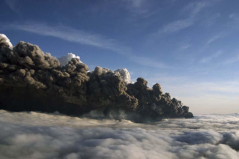
5 A large dark-grey volcanic cloud has been released at the end of April 14, drifting eastward at about 5-7 km of altitude Leading the European air space to be shut down a few hours later, until at least April 20 Source : NASA/Terra-MODIS, April 19, 2010,12:50 Directly impacted millions of people!


6 The volcanic ash-cloud
7 The eruption has been characterized by two main phases of intense ash emissions spanning April and May 1-10, with a maximum intensity recorded on M The volcanic ash-cloud The eruption has been characterized by two main phases of intense ash emissions spanning April and May 1-10, with a maximum intensity recorded on May 6
8 The volcanic ash-cloud The eruption stopped some weeks later on May 23, leading to a dormant phase

 Real-time products exploitation of MSG satellite (Meteosat Second Generation)")
9 Near-real-time monitoring of thermal anomalies Tracking of volcanic clouds related to the eruptive activity Estimation of quantitative parameters Constraints on ash plumes dynamics, from the vent to the atmosphere OPGC = reception platform for geostationary satellites data (EUMETSAT convention) Real-time products exploitation of MSG satellite (Meteosat Second Generation) HotVolc Group
10 Installation, in early 2009, of a real-time reception station of MSG data at Clermont-Ferrand. Real-Time Reception Antenna OPGC METEOSAT
 detailed study of volcanic plumes dynamics through time HOTVOLC MODVOLC MODIS 1 image / 12 hours METEOSAT 1 image / 15 min")
11 MSG-Seviri sensor (Spinning Enhanced Visible and InfraRed Imager) very high temporal resolution (1 image every 15 minutes - up to 5 minutes) and large spectral extent (12 channels from visible to infra-red wavelengths) detailed study of volcanic plumes dynamics through time HOTVOLC MODVOLC MODIS 1 image / 12 hours METEOSAT 1 image / 15 min

 SO 2 loading Ash index Aqua/Terra MODIS 4 img /")

12 Near-real-time quantitative assessment of volcanic parameters using multiple satellite-based tools, MSG, Aura-OMI, Terra/Aqua-MODIS, Calipso-CALIOP Satellites Sensors Temporal Resolution Spatial Resolution Spectral Domain Field Studies Aura OMI 1 img / 24h 12km 24km UV-VIS ( nm) SO 2 loading Ash index Aqua/Terra MODIS 4 img / 24h 1km 1km µm Ash loading SO 2 loading Calipso CALIOP 2 img / 24h 30m 333m nm Ash loading Ash properties Meteosat SEVIRI 1 img / 15min 3km 3km µm Ash loading SO 2 loading
. 24/7 monitoring survey (CMVOA Warning Cell), in order to detect any evolution of the volcanic activity in Iceland likely to have consequences in France.")
13 HOTVOLC was involved in the monitoring of the April 2010 eruption at Eyjafjöll (Iceland) and belonged to a volcano alert group, at the request of the MEEDDM (French Ministry for ecology, energy, durable development and sea). 24/7 monitoring survey (CMVOA Warning Cell), in order to detect any evolution of the volcanic activity in Iceland likely to have consequences in France. CMVOA Warning Cell Operational Warning and Alert Ministry Center Ministry IPGP-OPGC CMVOA CNRS-INSU METEO-FRANCE

14 HOTVOLC OBSERVATION SYSTEM (HVOS) 1- Eruption Alert Notice 2- Tracking volcanic products 3- Data diffusion Community
15 HOTVOLC OBSERVATION SYSTEM (HVOS) Eyjafjöll crisis From April 14, 2010, we provided reliable real-time MSG-9 images to the community every 15 minutes (up to every 5 minutes with MSG-8 RSS -Rapid Scan Service- images), Data immediately delivered to the scientific community on the HVOS website :
16 HotVolc Real-Time Products : Plume Mapping and Tracking Brightness Temperature Difference (BTD) Method (Prata, 1989) Detection of Volcanic ash from the negative BTD between the spectral bands at 11 and 12µm (thermal infra-red), Water droplets and ice crystals highlighted from BTD>0. Based on the differential extinction features of volcanic aerosols between different wavelengths. First channel : 10.8µm-12µm, Second channel : 10.8µm-8.7µm Third channel : 10.8µm 3-channels IR composition using MSG-9- SEVIRI data (3x3 km) Ash cloud in dark blue, Water droplets are green, Ice crystals are bright red

 HRV (High Resolution Visible, 1x1 km, 5min) MSG-8")
17 HotVolc Real-Time Products : Plume Mapping and Tracking Real-time MSG-9 every 15 min, up to every 5 min with MSG-8 RSS -Rapid Scan Service- images 3-channels IR composition using MSG-9-SEVIRI data (3x3 km, 15 min) HRV (High Resolution Visible, 1x1 km, 5min) MSG-8 RSS image
 Ash plume-track on West Europe important information on the cloud dispersal and")

18 HotVolc Real-Time Products : Plume Mapping and Tracking 3-channels thermal colored composition movie (06-08 May period) Ash plume-track on West Europe important information on the cloud dispersal and location. Ex. 6-8 Mai 2010 Ash cloud : dark blue Water droplets : deep green Ice crystals : bright red Chronology of ash dispersal area mapped from MSG-SEVIRI and the Lidar CALIOP- Calipso during the first few days
19 HotVolc Near-Real-Time Estimation of Quantificative Parameters Inversion algorithms of MSG-SEVIRI infrared data (Wen and Rose, 1994) based on the absorption and diffusion properties of volcanic ash allow a first order quantitative estimate of eruptive parameters. Ash Concentration Ash radius Give a minimum estimate of fine ash mass loading inside the cloud at a given instant. On May 6, 210kt of ash were airborne at that time, with the cloud having a maximum concentration of 5 mg.m -3. Ash cloud Altitude Median ash radius distribution at about 3.7 µm Mass flux of SO 2
20 HotVolc Near-Real-Time Estimation of Quantificative Parameters Ash cloud altitude Cloud temperatures calculated from the 10.8 µm channel, and the altitude to which that temperature related was retrieved from vertical atmospheric soundings. On May 6, highest point of the volcanic plume was 9.5 km a.s.l Ash Concentration Mass flux of SO 2 Ash radius SO 2 burden obtained using the Aura-OMI instrument which operates at UV wavelengths. Estimate of 15.1kt for SO 2 from the May 6 image. Ash cloud Altitude Mass flux of SO 2

21 HotVolc Near-Real-Time Estimation of Quantificative Parameters Mass Flux and Ash Concentration with time Ex. 6-8 Mai 2010 Quantitative information were routinely calculated within a few hours of image reception during the whole eruption. We used a total of about 3000 images, with SEVIRI being available at a typical rate of 96 images/day (one image every 15 minutes).

22 HotVolc Near-Real-Time Estimation of Quantificative Parameters Accurate mass fluxes estimation of fine ash emitted in the atmosphere Mean flux on the whole eruption : ~ 1.33t.s -1 with maximum of 5.3 t.s -1, minimum : 0.02 t.s -1 Total fine ash emissions ~ 2.3 Mt Total SO 2 emissions ~ 0.28 Mt From April 14 to May 9 in the atmosphere Ash emissions focused on 2 main phases : April and 1-10 May SO 2 emitted much more constantly
23 Remote sensing data can be used to accurately assess exact location, extent, ash concentration, mass flux and altitude of a volcanic plume. Improve plume monitoring and tracking, Allow improved communication and understanding by the media Answer to the question : Where was the plume and how dense was it? Our maps show that it was likely of Europe-wide extent. Our inability to detect any cloud in the south of France from satellite data suggests that the ash cloud was extremely dilute. In addition, ground-based or satellite LIDAR soundings revealed that the cloud was low and below the level of most transatlantic routes. A remaining question will need an argued answer in the next future : Could planes have flown over it?
24 Using a fully integrated data set of IR and UV images, we can track plumes in near-real-time at a high temporal resolution. Test web-based, real-time monitoring system with : automated ingestion of satellite data and output of maps and values to allow real-time ash cloud tracking as well as updating of cloud trajectory and dispersal models. Quantitative near-real-time information was available to the scientists, monitoring and media communities across the whole of Europe, and was part of the official crisis response implemented by the French government. Our fully transparent information broadcasting system is aimed to help achieve a fully informed and unified decision making and reporting process in the event of a volcanic ash crisis.
NEAR REAL-TIME MONITORING OF THE APRIL-MAY 2010 EYJAFJÖLL S ASH CLOUD. Contact : P.
 NEAR REAL-TIME MONITORING OF THE APRIL-MAY 2010 EYJAFJÖLL S ASH CLOUD Philippe Labazuy 1,2, Mathieu Gouhier 1, Yannick Guéhenneux 1, Andrew Harris 1, Maxime Hervo 3, Patrick Fréville 2, Jean- Claude Bergès
Satellite observation of atmospheric dust
 Satellite observation of atmospheric dust Taichu Y. Tanaka Meteorological Research Institute, Japan Meteorological Agency 11 April 2017, SDS WAS: Dust observation and modeling @WMO, Geneva Dust observations
Satellite Data For Applications: Aviation/Volcanic Ash. Richard Eckman NASA 27 May 2013
 Satellite Data For Applications: Aviation/Volcanic Ash Richard Eckman NASA 27 May 2013 Background Following the unprecedented disruption to aviation by the recent eruptions of Eyjafjallajökull and Grímsvötn
Validation and evaluation of SEVIRI volcanic ash heights
 Validation and evaluation of SEVIRI volcanic ash heights A.T.J. de Laat and R.J. van der A De Bilt, 2012 Technical report; TR-337 Validation and evaluation of SEVIRI volcanic ash heights. Version 1.0
A-Train observations of the 2010 eruption of Eyjafjallajökull volcano (Iceland)
") A-Train observations of the 2010 eruption of Eyjafjallajökull volcano (Iceland) S.A. Carn 1, N.A. Krotkov 2, K. Yang 2, A.J. Prata 3 1. Michigan Technological University, Houghton, MI, USA 2. GEST Center,
A-Train observations of the 2010 eruption of Eyjafjallajökull volcano (Iceland) S.A. Carn 1, N.A. Krotkov 2, K. Yang 2, A.J. Prata 3 1. Michigan Technological University, Houghton, MI, USA 2. GEST Center,
Volcanic ash emergency in Northern Europe
 FORMAT-EO Leicester Volcanic ash emergency in Northern Europe The application of remote sensing techniques Group 3 Carlos Melo; Stefano Capobianco & Rejanne Le Bivic Tutor: Alfredo Falconieri 2013 Introduction
Current capabilities and limitations of satellite monitoring and modeling forecasting of volcanic clouds: and example of Eyjafjallaj
 Current capabilities and limitations of satellite monitoring and modeling forecasting of volcanic clouds: and example of Eyjafjallaj fjallajökull eruption (pronounced EYE-a-fyat fyat-la-jo-kotl) N. Krotkov
Images from: Boston.com
 Images from: Boston.com Ireland in the shadow of a volcano: Understanding the 2010 eruption at Eyjafjallajökull, Iceland. Chris Bean, School of Geological Sciences, UCD. World Quakes and Volcanoes 1960-2010
University of Bristol - Explore Bristol Research
 Prata, F., Woodhouse, M. J., Huppert, H. E., Prata, A., Thordarson, TH., & Carn, S. A. (2017). Atmospheric processes affecting the separation of volcanic ash and SO2 in volcanic eruptions: Inferences from
Recommendation proposed: CGMS-39 WGII to take note.
 Prepared by EUMETSAT Agenda Item: G.II/8 Discussed in WGII EUM REPORT ON CAPABILITIES AND PLANS TO SUPPORT VOLCANIC ASH MONITORING In response to CGMS action WGII 38.31: CGMS satellite operators are invited
IVATF/4-WP/11 Revision 1 07/06/12. International WORKING PAPER IVATF TASK. (Presented SUMMARY 1.1. (5 pages)
") International Civil Aviation Organization WORKING PAPER Revision 1 07/06/12 INTERNATIONAL VOLCANIC ASH TASK FORCE (IVATF) FOURTH MEETING Montréal, 13 to 15 June 2012 Agenda Item 2: Report of the science
International Civil Aviation Organization WORKING PAPER Revision 1 07/06/12 INTERNATIONAL VOLCANIC ASH TASK FORCE (IVATF) FOURTH MEETING Montréal, 13 to 15 June 2012 Agenda Item 2: Report of the science
Eyja volcanic ash retrievals by using MODIS data
 INGV Eyja volcanic ash retrievals by using MODIS data S. Corradini, L. Merucci, A. Piscini Remote Sensing Group INGV (Rome) ESRIN May 26-27, 2010 Outline Ash retrieval algorithms in the TIR spectral range
PHEOS - Weather, Climate, Air Quality
 Aerosol & cloud remote sensing over the Arctic : perspectives for the PHEMOS and meteorological imager payloads on the PCW mission Norm O Neill, Auromeet Saha, U. de Sherbrooke Chris E. Sioris, Jack McConnell,
Eyjafjallajökull 2010: Ash and aerosol during and after the eruption
 Eyjafjallajökull 2010: Ash and aerosol during and after the eruption { Evgenia Ilyinskaya, Guðrún Nína Petersen, Sibylle von Löwis, Halldór Björnsson, Matthew J. Roberts, Steinunn S. Jakobsdóttir, Sigurlaug
Earthquakes and volcanoes in Iceland
 Jenny Jenkins Daði Harðarson Explosive Earth Earthquakes and volcanoes in Iceland The eruption of Bárðarbunga volcano in Iceland, July 2014 Key words volcano earthquake seismology prediction Bárðarbunga
A - Piton de la Fournaise activity
 OVPF-IPGP August 2018 Page 1/7 Monthly bulletin of the Piton de la Fournaise Volcanological Observatory ISSN ISSN 2610-5101 A - Piton de la Fournaise activity PITON DE LA FOURNAISE (VNUM #233020) Latitude:
The 2010 Eyjafjallajökull eruption: overview and OMI observations. Simon A. Carn Michigan Technological University, Houghton, MI, USA
 The 2010 Eyjafjallajökull eruption: overview and OMI observations Simon A. Carn Michigan Technological University, Houghton, MI, USA Global air routes and potentially active volcanoes Map courtesy of F.
Requirements for a survey system of active volcanoes based on muon radiography
 Requirements for a survey system of active volcanoes based on muon radiography Philippe LABAZUY on behalf of the TOMUVOL Collaboration http://www.tomuvol.fr/ Laboratoire Magmas et Volcans, Laboratoire
The Eyjafjallajokull volcanic eruption
 Explain the formation of the volcano E15 and the causes of its eruptions. Describe the effects of the 2010 eruption. Make sure you can categorise these according to whether they are primary or secondary
P3.13 GLOBAL COMPOSITE OF VOLCANIC ASH SPLIT ` WINDOW GEOSTATIONARY SATELLITE IMAGES
 P3.13 GLOBAL COMPOSITE OF VOLCANIC ASH SPLIT ` WINDOW GEOSTATIONARY SATELLITE IMAGES Frederick R. Mosher * Embry-Riddle Aeronautical University Daytona Beach, FL 1.0 Introduction Volcanic ash is exceptionally
REFERENCE: The Blue Planet An Introduction to Earth System Science. Brian J. Skinner and Barbara W. Murck (2011) Third Edition. John Wiley and Sons
 Third Edition. John Wiley and Sons") REFERENCE: The Blue Planet An Introduction to Earth System Science. Brian J. Skinner and Barbara W. Murck (2011) Third Edition. John Wiley and Sons Inc. PLATE BOUNDARIES OCEAN FLOOR SEISMIC ACTIVITY WORLD'S
REFERENCE: The Blue Planet An Introduction to Earth System Science. Brian J. Skinner and Barbara W. Murck (2011) Third Edition. John Wiley and Sons Inc. PLATE BOUNDARIES OCEAN FLOOR SEISMIC ACTIVITY WORLD'S
Satellite techniques for timely detection and near real-time monitoring of volcanic ash clouds for aviation safety
 Satellite techniques for timely detection and near real-time monitoring of volcanic ash clouds for aviation safety N. Pergola A. Falconieri F. Marchese V. Tramutoli Consiglio Nazionale delle Ricerche Istituto
Supporting the response to the 2018 lower East Rift Zone and summit collapse at Kīlauea Volcano, Hawaiʻi
 Hawaiʻi Supersite success story Supporting the response to the 2018 lower East Rift Zone and summit collapse at Kīlauea Volcano, Hawaiʻi Since 1983, Kīlauea Volcano, on the Island of Hawaiʻi, has actively
Explosive volcanic eruptions in the North Pacific: Interactions between the Alaska Volcano Observatory and Volcanic Ash Advisory Centers
 Explosive volcanic eruptions in the North Pacific: Interactions between the Alaska Volcano Observatory and Volcanic Ash Advisory Centers David Schneider U.S. Geological Survey Alaska Volcano Observatory
European Natural Airborne Disaster Information and Coordination System for Aviation
 European Natural Airborne Disaster Information and Coordination System for Aviation Marcus Hirtl (ZAMG) + the EUNADICS-AV Team Background Eyjafjallajökull eruption April May 2010 Aviation is one of the
Volcanoes drive climate variability by
 Volcanoes drive climate variability by 1. emitting ozone weeks before eruptions, 2. forming lower stratospheric aerosols that cool Earth, 3. causing sustained ozone depletion, surface warming, and lower
Monitoring trace gas emissions and transport with Aura and the A-Train
 Monitoring trace gas emissions and transport with Aura and the A-Train Simon Carn Dept. of Geological and Mining Engineering, Michigan Technological University, Houghton, MI Aura (2004-) OMI - SO 2, NO
EUMETNET Statement for the EASA Workshop Volcanic Ash Cloud: Detection, Observation, Measurement, Modelling The Way Forward
 EUMETNET Statement for the EASA Workshop Volcanic Ash Cloud: Detection, Observation, Measurement, Modelling The Way Forward Cologne, 21 st June 2010 Background GIE EUMETNET (the network of European Meteorological
DIFFERING REGIONAL CAPABILITIES IN SATELLITE-BASED VOLCANIC ASH CLOUD DETECTION
 Prepared by NOAA Agenda Item: II/8 Discussed in WGII DIFFERING REGIONAL CAPABILITIES IN SATELLITE-BASED VOLCANIC ASH CLOUD DETECTION The GOES-R AWG is responsible for the developing the algorithms that
Volcanic SO 2 by UV-TIR satellite retrievals: validation by using ground-based network at Mt. Etna
 ; doi: 10.4401/ag-6641 Volcanic SO 2 by UV-TIR satellite retrievals: validation by using ground-based network at Mt. Etna CLAUDIA SPINETTI 1 *, GIUSEPPE GIOVANNI SALERNO 1, TOMMASO CALTABIANO 1, ELISA
Development of volcanic ash product for the next-generation Japanese Geostationary Meteorological Satellite Himawari-8
 Development of volcanic ash product for the next-generation Japanese Geostationary Meteorological Satellite Himawari-8 Hiroaki Tsuchiyama 1, Yukio Kurihara 1, Kazuhiko Masuda 2 (1) Japan Meteorological
Pavlof. Alaska Peninsula N, W; summit elev. 2,519 m. All times are local (= UTC - 9 hours)
") Pavlof Alaska Peninsula 55.42 N, 161.887 W; summit elev. 2,519 m All times are local (= UTC - 9 hours) Eruption in May-June 2013 with lava flows and ash emissions to ~8.5 km a.s.l. Pavlof, the most active
Pavlof Alaska Peninsula 55.42 N, 161.887 W; summit elev. 2,519 m All times are local (= UTC - 9 hours) Eruption in May-June 2013 with lava flows and ash emissions to ~8.5 km a.s.l. Pavlof, the most active
SACS & SACS2 an overview and recent developments
 SACS & SACS2 an overview and recent developments L. Clarisse (1), N. Theys (2), H. Brenot (2), J. van Gent (2), R. van der A (4), P. Valks (5), M. Van Roozendael (2), D. Hurtmans (1), P.-F. Coheur (1),
Volcanic, Weather and Climate Effects on Air Transport
 Volcanic, Weather and Climate Effects on Air Transport Ulrich Schumann German Aerospace Center Institute of Atmospheric Physics Oberpfaffenhofen, Germany Content: - Volcanic ash hazard avoidance by improved
Advantageous GOES IR results for ash mapping at high latitudes: Cleveland eruptions 2001
 GEOPHYSICAL RESEARCH LETTERS, VOL. 32, L02305, doi:10.1029/2004gl021651, 2005 Advantageous GOES IR results for ash mapping at high latitudes: Cleveland eruptions 2001 Yingxin Gu, 1 William I. Rose, 1 David
SAFNWC/MSG Dust flag.
 SAFNWC/MSG Dust flag. Dust Week 1-5 March 2010 Hervé LE GLEAU, Marcel DERRIEN Centre de météorologie Spatiale. Lannion Météo-France 1 Plan SAFNWC context Dust flag in SAFNWC/MSG Cma product Algorithm description
A short meteorological overview of the Eyjafjallajökull eruption 14 April 23 May 2010
 A short meteorological overview of the Eyjafjallajökull eruption 14 April 23 May 2010 Guðrún Nína Petersen Icelandic Met Office, Reykjavík Introduction Eyjafjallajökull is an ice-capped stratovolcano with
Remote Detection and Monitoring of Volcanic Eruptions in the East African Rift
 Remote Detection and Monitoring of Volcanic Eruptions in the East African Rift Simon Carn 1, David Fee 2, Fred Prata 3 1 Department of Geological and Mining Engineering and Sciences, Michigan Technological
A - Piton de la Fournaise activity
 OVPF-IPGP September 2018 Page 1/10 Monthly bulletin of the Piton de la Fournaise Volcanological Observatory ISSN ISSN 2610-5101 A - Piton de la Fournaise activity PITON DE LA FOURNAISE (VNUM #233020) Latitude:
SAFNWC/MSG SEVIRI CLOUD PRODUCTS
 SAFNWC/MSG SEVIRI CLOUD PRODUCTS M. Derrien and H. Le Gléau Météo-France / DP / Centre de Météorologie Spatiale BP 147 22302 Lannion. France ABSTRACT Within the SAF in support to Nowcasting and Very Short
A - Piton de la Fournaise activity
 OVPF-IPGP November 2018 Page 1/7 Monthly bulletin of the Piton de la Fournaise Volcanological Observatory ISSN ISSN 2610-5101 A - Piton de la Fournaise activity PITON DE LA FOURNAISE (VNUM #233020) Latitude:
Incorporating Volcanic Eruptions into Near Real time Aerosol Forecasts
 Incorporating Volcanic Eruptions into Near Real time Aerosol Forecasts Eric Hughes 1 Nick Krotkov 2 Arlindo Da Silva 2 Peter Colarco 2 (1) University of MD Department of Atmospheric and Oceanic Sciences
MSGVIEW: AN OPERATIONAL AND TRAINING TOOL TO PROCESS, ANALYZE AND VISUALIZATION OF MSG SEVIRI DATA
 MSGVIEW: AN OPERATIONAL AND TRAINING TOOL TO PROCESS, ANALYZE AND VISUALIZATION OF MSG SEVIRI DATA Aydın Gürol Ertürk Turkish State Meteorological Service, Remote Sensing Division, CC 401, Kalaba Ankara,
Satellite data for African applications
 Satellite data for African applications Henk Verschuur, EUMETSAT henk.verschuur@eumetsat.int Introduction Some examples of satellite products which are useful for Africa Satellite products Tropical cyclones
The identification and tracking of volcanic ash using the Meteosat Second Generation (MSG) Spinning Enhanced Visible and Infrared Imager (SEVIRI)
 Spinning Enhanced Visible and Infrared Imager (SEVIRI)") doi:10.5194/amt-7-581-2014 Author(s) 2014. CC Attribution 3.0 License. Atmospheric Measurement Techniques Open Access The identification and tracking of volcanic ash using the Meteosat Second Generation
doi:10.5194/amt-7-581-2014 Author(s) 2014. CC Attribution 3.0 License. Atmospheric Measurement Techniques Open Access The identification and tracking of volcanic ash using the Meteosat Second Generation
Module 1, Investigation 3: Predicting Eruptions
 Module 1, Investigation 3: Predicting Eruptions Introduction Welcome! Volcanoes are either "active" or "extinct". Active means that the volcano has erupted during the past 10,000 years. It can also mean
OSI SAF SST Products and Services
 OSI SAF SST Products and Services Pierre Le Borgne Météo-France/DP/CMS (With G. Legendre, A. Marsouin, S. Péré, S. Philippe, H. Roquet) 2 Outline Satellite IR radiometric measurements From Brightness Temperatures
MONITORING OF VOLCANIC ERUPTIONS AND DETERMINATION OF SO 2 PLUME HEIGHT FROM GOME-2 MEASUREMENTS
 MONITORING OF VOLCANIC ERUPTIONS AND DETERMINATION OF SO 2 PLUME HEIGHT FROM GOME-2 MEASUREMENTS M. Rix (1) (2), P. Valks (1), D. Loyola (1), C. Maerker (1), K. Seidenberger (1), J. van Gent (3), M. van
Volcanic plume modelling and assimilation with the global MACC system (with emphasis on SO 2 )
") Volcanic plume modelling and assimilation with the global MACC system (with emphasis on SO 2 ) Johannes Flemming, Antje Inness, Angela Benedetti & Jean-Jacques Morcrette Introduction How can we use timely
Volcanic plume modelling and assimilation with the global MACC system (with emphasis on SO 2 ) Johannes Flemming, Antje Inness, Angela Benedetti & Jean-Jacques Morcrette Introduction How can we use timely
( ) USGS (United States Geological Survey) Watch Green. Normal. alert level 1 Normal
 USGS (United States Geological Survey) Watch Green. Normal. alert level 1 Normal") (200610.1) USGS (United States Geological Survey) 1014 alert level 1 Normal Watch Green Normal USGS WARNING WATCH ADVISORY NORMAL SUMMARY OF VOLCANIC-ALERT LEVELS Highly hazardous eruption underway or
(200610.1) USGS (United States Geological Survey) 1014 alert level 1 Normal Watch Green Normal USGS WARNING WATCH ADVISORY NORMAL SUMMARY OF VOLCANIC-ALERT LEVELS Highly hazardous eruption underway or
The Eyjafjallajokull Volcanic Ash Cloud and its Effects on Scottish Air Quality. Update 06 May 2010
 The Eyjafjallajokull Volcanic Ash Cloud and its Effects on Scottish Air Quality. Update 06 May 2010 The volcanic ash cloud from the Eyjafjallakull volcano once again grounded flights from Scottish airports
Comparison of methodologies for SO 2 and Ash identification using observations from IASI
 Comparison of methodologies for SO 2 and Ash identification using observations from IASI Maria Athanassiadou, Peter N Francis, Stephan Havemann, Elisa Carboni EGU, 15 Apr., 2015 This talk is about... IASI
THE LAND-SAF SURFACE ALBEDO AND DOWNWELLING SHORTWAVE RADIATION FLUX PRODUCTS
 THE LAND-SAF SURFACE ALBEDO AND DOWNWELLING SHORTWAVE RADIATION FLUX PRODUCTS Bernhard Geiger, Dulce Lajas, Laurent Franchistéguy, Dominique Carrer, Jean-Louis Roujean, Siham Lanjeri, and Catherine Meurey
Nerushev A.F., Barkhatov A.E. Research and Production Association "Typhoon" 4 Pobedy Street, , Obninsk, Kaluga Region, Russia.
 DETERMINATION OF ATMOSPHERIC CHARACTERISTICS IN THE ZONE OF ACTION OF EXTRA-TROPICAL CYCLONE XYNTHIA (FEBRUARY 2010) INFERRED FROM SATELLITE MEASUREMENT DATA Nerushev A.F., Barkhatov A.E. Research and
Meteosat Third Generation (MTG): Lightning Imager and its products Jochen Grandell
: Lightning Imager and its products Jochen Grandell") 1 Go to View menu and click on Slide Master to update this footer. Include DM reference, version number and date Meteosat Third Generation (MTG): Lightning Imager and its products Jochen Grandell Topics
1 Go to View menu and click on Slide Master to update this footer. Include DM reference, version number and date Meteosat Third Generation (MTG): Lightning Imager and its products Jochen Grandell Topics
Development of a System for Quantitatively Analyzing Volcanic Clouds
 Development of a System for Quantitatively Analyzing Volcanic Clouds Michael Pavolonis (NOAA/NESDIS/STAR) Justin Sieglaff and John Cintineo (UW-CIMSS) Marco Fulle - www.stromboli.net 2 nd IUGG-WMO Workshop
Volcanic Ash Monitoring Claus Zehner, ESA
 Volcanic Ash Monitoring Claus Zehner, ESA Slide: 1 Support to Aviation Control Service A global Alert (and Analysis demonstration only) system for volcanic Ash and SO2 emissions using satellite measurements
EUMETSAT Satellite Programmes Use of McIDAS at EUMETSAT
 EUMETSAT Satellite Programmes Use of McIDAS at EUMETSAT Marianne König Peter Miu McIDAS Users' Group Meeting, 07-10 May 2012 Slide 1 EUMETSAT Headquarters Darmstadt McIDAS Users' Group Meeting, 07-10 May
Volcanic ash retrieval at Mt. Etna using Avhrr and Modis data
 Volcanic ash retrieval at Mt. Etna using Avhrr and Modis data Claudia Spinetti* a, Stefano Corradini a, Maria F. Buongiorno a a Istituto Nazionale di Geofisica e Vulcanologia, via di Vigna Murata, 605
MSG system over view
 MSG system over view 1 Introduction METEOSAT SECOND GENERATION Overview 2 MSG Missions and Services 3 The SEVIRI Instrument 4 The MSG Ground Segment 5 SAF Network 6 Conclusions METEOSAT SECOND GENERATION
Volcanic eruptions: Introduction to remote sensing techniques for fine ash and SO2 detection
 Volcanic eruptions: Introduction to remote sensing techniques for fine ash and SO2 detection Bernie Connell Cooperative Institute for Research in the Atmosphere Colorado State University USA Ash clouds
Response of the London Volcanic Ash Advisory Centre to the Eyjafjallajökull Eruption
 Paper 1B.3 Response of the London Volcanic Ash Advisory Centre to the Eyjafjallajökull Eruption Ian Lisk, Volcanic Ash Programme Manager, Met Office, UK 1. INTRODUCTION The Met Office is home to the London
GPS Radio Occultation for studying extreme events
 GPS Radio Occultation for studying extreme events Riccardo Biondi (1), A. K. Steiner (1), T. Rieckh (1) and G. Kirchengast (1,2) (1) Wegener Center for Climate and Global Change, University of Graz, Austria
New capabilities with high resolution cloud micro-structure facilitated by MTG 2.3 um channel
 Slide 19 November 2016, V1.0 New capabilities with high resolution cloud micro-structure facilitated by MTG 2.3 um channel Author: Daniel Rosenfeld The Hebrew University of Jerusalem (HUJ) daniel.rosenfeld@huji.ac.il
FUNDAMENTALS OF REMOTE SENSING FOR RISKS ASSESSMENT. 1. Introduction
 FUNDAMENTALS OF REMOTE SENSING FOR RISKS ASSESSMENT FRANÇOIS BECKER International Space University and University Louis Pasteur, Strasbourg, France; E-mail: becker@isu.isunet.edu Abstract. Remote sensing
A unified, global aerosol dataset from MERIS, (A)ATSR and SEVIRI
ATSR and SEVIRI") A unified, global aerosol dataset from MERIS, and SEVIRI Gareth Thomas gthomas@atm.ox.ac.uk Introduction GlobAEROSOL is part of the ESA Data User Element programme. It aims to provide a global aerosol
A unified, global aerosol dataset from MERIS, and SEVIRI Gareth Thomas gthomas@atm.ox.ac.uk Introduction GlobAEROSOL is part of the ESA Data User Element programme. It aims to provide a global aerosol
Dispersion modelling and warnings for volcanic ash in the Australian Region
 Dispersion modelling and warnings for volcanic ash in the Australian Region R Potts, R Dare, E Jansons, C Lucas, A Tupper, M Zidikheri The Centre for Australian Weather and Climate Research A partnership
Investigation 3: Predicting Eruptions
 Investigation 3: Predicting Eruptions Table of Contents Folder 1: Seismic Activity... 23 Folder 2: Ground Deformation (Mount St. Helens, Washington)... 25 Folder 3: Hot Spots... 26 Folder 4: Gas Emissions...
Satellite remote sensing of trace gases - Nadir sounding geometry. Cathy Clerbaux, DR CNRS, LATMOS/IPSL
 Satellite remote sensing of trace gases - Nadir sounding geometry Cathy Clerbaux, DR CNRS, LATMOS/IPSL Cathy.clerbaux@latmos.ipsl.fr Sounding the bottom of the atmosphere Endeavour STS-130 Atmospheric
Météo-France update : past evolution of the MOCAGE model and research results
 Météo-France update : past evolution of the MOCAGE model and research results Guth J., Asencio N., Descheemaecker M., El Amraoui L., Joly M., Marécal V., Plu M., Sic B.* 1 CNRM/Météo-France, Toulouse,
Nick Varley Universidad de Colima, Mexico
 Nick Varley Universidad de Colima, Mexico nick@ucol.mx Remote sensing often is the first signal of a new eruption for remote volcanoes Fumarole direct temperature measurements Spring water temperatures
Preparation for Himawari 8
 Preparation for Himawari 8 Japan Meteorological Agency Meteorological Satellite Center Hidehiko MURATA ET SUP 8, WMO HQ, Geneva, 14 17 April 2014 1/18 Introduction Background The Japan Meteorological Agency
GEOLOGY 285: INTRO. PETROLOGY
 Dr. Helen Lang Dept. of Geology & Geography West Virginia University FALL 2005 GEOLOGY 285: INTRO. PETROLOGY Mount St. Helens 1980 Eruption Small earthquakes Small steam and ash eruptions in March and
NASA-led campaign studies Hawaii's iconic volcanoes 9 February 2017, by Alan Buis
 NASA-led campaign studies Hawaii's iconic volcanoes 9 February 2017, by Alan Buis Night view of Hawaii's Kilauea Volcano, one of Earth's most active volcanoes. A NASA-led team is studying Hawaiian volcanoes
Augustine Volcano, Calculating Ash Fallout
 Augustine Volcano, 1986 - Calculating Fallout -What controls the fallout of particles through the atmosphere? -Can we predict when and where an erupted ash cloud will fall out on the Earth? Summit: 1260
SIMULATION OF AT-SENSOR RADIANCE OVER VOLCANOES FOR NIRST SENSOR
 SIMULATION OF AT-SENSOR RADIANCE OVER VOLCANOES FOR NIRST SENSOR M. Silvestri, D. Randazzo, M. F. Buongiorno, M. Musacchio Istituto Nazionale di Geofisica e Vulcanologia, Rome, Italy 7th Aquarius/SAC-D
MER from ground observations: practices and progresses at Osservatorio Etneo for measuring ash clouds-forming eruptions of the Etna volcano
 MER from ground observations: practices and progresses at Osservatorio Etneo for measuring ash clouds-forming eruptions of the Etna volcano Mauro Coltelli INGV Osservatorio Etneo, Catania, Italy MeMoVolc
GENERATION OF HIMAWARI-8 AMVs USING THE FUTURE MTG AMV PROCESSOR
 GENERATION OF HIMAWARI-8 AMVs USING THE FUTURE MTG AMV PROCESSOR Manuel Carranza 1, Régis Borde 2, Masahiro Hayashi 3 1 GMV Aerospace and Defence S.A. at EUMETSAT, Eumetsat Allee 1, D-64295 Darmstadt,
Directed Reading. Section: Volcanic Eruptions. light in color is called a. felsic. b. oceanic. c. mantle. d. mafic. dark in color is called
 Skills Worksheet Directed Reading Section: Volcanic Eruptions 1. Lava provides an opportunity for scientists to study a. the nature of Earth s inner core. b. the nature of Earth s tectonic plates. c. temperatures
FOUNDATIONS OF GEOLOGY CHAPTER 2
 FOUNDATIONS OF GEOLOGY CHAPTER 2 2.3A- VOLCANOES Volcanoes all share common characteristics. Vent- a central channel through which gases, ash and rock are ejected. Magma- molten rock which lies several
Atmospheric Motion Vectors: Product Guide
 Atmospheric Motion Vectors: Product Guide Doc.No. Issue : : EUM/TSS/MAN/14/786435 v1a EUMETSAT Eumetsat-Allee 1, D-64295 Darmstadt, Germany Tel: +49 6151 807-7 Fax: +49 6151 807 555 Date : 9 April 2015
INTERNATIONAL AIRWAYS VOLCANO WATCH OPERATIONS GROUP (IAVWOPSG)
") International Civil Aviation Organization IAVWOPSG/8-WP/39 13/1/14 WORKING PAPER INTERNATIONAL AIRWAYS VOLCANO WATCH OPERATIONS GROUP (IAVWOPSG) EIGHTH MEETING Melbourne, Australia, 17 to 20 February 2014
International Civil Aviation Organization IAVWOPSG/8-WP/39 13/1/14 WORKING PAPER INTERNATIONAL AIRWAYS VOLCANO WATCH OPERATIONS GROUP (IAVWOPSG) EIGHTH MEETING Melbourne, Australia, 17 to 20 February 2014
SIMULATED VOLCANIC ASH SATELLITE IMAGERY
 SIMULTE VOLNI SH STELLITE IMGERY Sarah Millington (1), Roger Saunders (1), Peter Francis (1), Michael ooke (1), Frances eckett (1), John Stevenson (2) (1) Met Office, FitzRoy Road, Exeter, EX1 3P, UK,
ttp://news.discovery.com/earth/iceland-volcano-aurora.html
 ttp://news.discovery.com/earth/iceland-volcano-aurora.html Outline Role of volcanism on the climate system Distribution of Arctic volcanoes Types of eruptions Frequency of Arctic eruptions Influence on
Results from the ARM Mobile Facility
 AMMA Workshop, Toulouse, November 2006 Results from the ARM Mobile Facility Background Anthony Slingo Environmental Systems Science Centre University of Reading, UK Selected results, including a major
Volcanic Ash Cloud Observations with the DLR- Falcon over Europe during Air Space Closure
 Volcanic Ash Cloud Observations with the DLR- Falcon over Europe during Air Space Closure Ulrich Schumann, Bernadett Weinzierl, Oliver Reitebuch, Andreas Minikin, Hans Schlager, Stephan Rahm, Monika Scheibe,
A statistical approach for rainfall confidence estimation using MSG-SEVIRI observations
 A statistical approach for rainfall confidence estimation using MSG-SEVIRI observations Elisabetta Ricciardelli*, Filomena Romano*, Nico Cimini*, Frank Silvio Marzano, Vincenzo Cuomo* *Institute of Methodologies
Monthly Volcanic Activity Report (February 2016)
") Monthly Volcanic Activity Report (February 2016) Japan Meteorological Agency Azumayama (Alert Level: 2) Fumarolic activity at the Oana crater has remained at relatively high levels. Aerial observation
Monthly Volcanic Activity Report (February 2016) Japan Meteorological Agency Azumayama (Alert Level: 2) Fumarolic activity at the Oana crater has remained at relatively high levels. Aerial observation
NSF-MARGINS Expedition to Anatahan Volcano March 2005
 1 NSF-MARGINS Expedition to Anatahan Volcano March 2005 According to the Emergency Management Office (EMO) report distributed in February 2005, the third historical eruption of Anatahan began on January
Introduction to volcanoes. Volcano: an opening in the earth s surface through which lava, hot gases, and rock fragments erupt
 Introduction to volcanoes Volcano: an opening in the earth s surface through which lava, hot gases, and rock fragments erupt Origin of Volcanoes 1. Magma 50-100 miles below the earth s surface slowly begins
Tephra sedimentation during the 2010 Eyjafjallajökull eruption (Iceland) from deposit, radar, and satellite observations
 from deposit, radar, and satellite observations") JOURNAL OF GEOPHYSICAL RESEARCH, VOL. 116,, doi:10.1029/2011jb008462, 2011 Tephra sedimentation during the 2010 Eyjafjallajökull eruption (Iceland) from deposit, radar, and satellite observations C. Bonadonna,
JOURNAL OF GEOPHYSICAL RESEARCH, VOL. 116,, doi:10.1029/2011jb008462, 2011 Tephra sedimentation during the 2010 Eyjafjallajökull eruption (Iceland) from deposit, radar, and satellite observations C. Bonadonna,
METEOSAT THIRD GENERATION
 METEOSAT THIRD GENERATION FACTS AND FIGURES MONITORING WEATHER AND CLIMATE FROM SPACE A HIGHLY INNOVATIVE GEOSTATIONARY SATELLITE SYSTEM FOR EUROPE AND AFRICA The Meteosat Third Generation (MTG) system
A new perspective on aerosol direct radiative effects in South Atlantic and Southern Africa
 A new perspective on aerosol direct radiative effects in South Atlantic and Southern Africa Ian Chang and Sundar A. Christopher Department of Atmospheric Science University of Alabama in Huntsville, U.S.A.
Applications of the SEVIRI window channels in the infrared.
 Applications of the SEVIRI window channels in the infrared jose.prieto@eumetsat.int SEVIRI CHANNELS Properties Channel Cloud Gases Application HRV 0.7 Absorption Scattering
What are Aerosols? Suspension of very small solid particles or liquid droplets Radii typically in the range of 10nm to
 What are Aerosols? Suspension of very small solid particles or liquid droplets Radii typically in the range of 10nm to 10µm Concentrations decrease exponentially with height N(z) = N(0)exp(-z/H) Long-lived
Airborne aerosol in-situ observations of volcanic ash layers of the Eyjafjallajökull volcano in April & May, 2010, over central Europe
 Airborne aerosol in-situ observations of volcanic ash layers of the Eyjafjallajökull volcano in April & May, 2010, over central Europe A. Minikin, B. Weinzierl, O. Reitebuch, H. Schlager, M. Scheibe, M.
Global observations from CALIPSO
 Global observations from CALIPSO Dave Winker, Chip Trepte, and the CALIPSO team NRL, Monterey, 27-29 April 2010 Mission Overview Features: Two-wavelength backscatter lidar First spaceborne polarization
Eldgos í Eyjafjallajökli hlutverk Veðurstofu Íslands
 Photo: B. Pálmason Eldgos í Eyjafjallajökli hlutverk Veðurstofu Íslands Sigrún Karlsdóttir, Guðrún Nína Petersen, Halldór Björnsson, Halldór Pétursson, Hróbjartur Þorsteinsson, Kristín Vogfjörð og Þórður
Earthquake and Volcano Service
 Ref. Ares(2014)73773-15/01/2014 Earthquake and Volcano Service WP Leader: Istituto Nazionale di Geofisica e Vulcanologia (Italy) Contributors: NILU (Norway), EUCENTRE (Italy), GAMMA (Switzerland), IGAR
Lecture 4b: Meteorological Satellites and Instruments. Acknowledgement: Dr. S. Kidder at Colorado State Univ.
 Lecture 4b: Meteorological Satellites and Instruments Acknowledgement: Dr. S. Kidder at Colorado State Univ. US Geostationary satellites - GOES (Geostationary Operational Environmental Satellites) US