Meteosat Third Generation (MTG): Lightning Imager and its products Jochen Grandell
|
|
|
- Jonathan Lawrence
- 5 years ago
- Views:
Transcription
: Lightning Imager")
1 1 Go to View menu and click on Slide Master to update this footer. Include DM reference, version number and date Meteosat Third Generation (MTG): Lightning Imager and its products Jochen Grandell
2 Topics Putting Meteosat Third Generation (MTG) into context Lightning monitoring from space how does the concept work MTG Lightning Imager Design and characteristics User products Proxy data development Summary 2

3 Who am I... Jochen Grandell Finnish With EUMETSAT since 2002 Until very recently MTG Lightning Imager mission scientist Now Atmospheric and imagery applications manager (it was cold while taking this picture...) 3


4 Where am I... EUMETSAT headquarters in Darmstadt, Germany 4

5 Where I would like to be... 5
6 Topics Putting Meteosat Third Generation (MTG) into context Lightning monitoring from space how does the concept work MTG Lightning Imager Design and characteristics User products Proxy data development Summary 6


 via GMES")
7 MTG to Secure Continuity and Evolution of EUMETSAT Services and 2021 MOP/MTP MOP/MTP MSG MSG MTG-I and MTG-S Observation mission: - MVIRI: 3 channels Spinning satellite Class 800 kg Observation missions: - SEVIRI: 12 channels - GERB Spinning satellite Class 2-ton Observation missions: - Flex.Comb. Imager: 16 channels - Infra-Red Sounder - Lightning Imager - UVN (*) 3-axis stabilised satellites (two-satellite configuration) (*) Ultraviolet Visible Near-infrared spectrometer (UVN-S4) via GMES Sentinel 4 7 Slide: 7
8 Topics Putting Meteosat Third Generation (MTG) into context Lightning monitoring from space how does the concept work MTG Lightning Imager Design and characteristics User products Proxy data development Summary 8


 1995-2000 Results from LIS/OTD:")
")
9 Lightning Detection from Space from LEO to GEO Feasibility of lightning detection from space by optical sensors has been proven by NASA instruments since 1995 on low earth orbits (LEO) Optical Transient Detector (OTD) Results from LIS/OTD: Global lightning distribution Annual flash density Lightning Imaging Sensor (LIS) 1997-present 9
10 Geostationary lightning imaging objectives and benefits The LI on MTG measures Total Lightning: Cloud-to-Cloud Lightning (IC) and Cloud-to-Ground Lightning (CG) Main benefit from GEO observations: homogeneous and continuous observations delivering information on location and strength of lightning flashes to the users with a timeliness of 30 seconds Main objectives are to detect, monitor, track and extrapolate in time: Development of active convective areas and storm lifecycle Lightning climatology Chemistry (NOx production) 10
11 Detection of a Lightning Optical Signal Lightning with a background signal (bright clouds) changing with time: Radiation Energy at nm Background Lightning signal Day Night Time Lightning is not recognized by its bright radiance alone, but by its transient short pulse character (also against a bright background) Variable adapting threshold has to be used for each pixel which takes into account the change in the background radiance 11 Slide: 11
LF (Very) Low")
12 Thunderstorm Electrification Lightning and its Emissions VHF Very High Frequency, (V)LF (Very) Low Frequency 12
13 Topics Putting Meteosat Third Generation (MTG) into context Lightning monitoring from space how does the concept work MTG Lightning Imager Design and characteristics User products Proxy data development Summary 13

14 Lightning Imager (LI) design CMOS Back-thinned backside illuminated detectors with integrated ADCs The baseline for the LI is a 4-camera solution 1170 x 1000 pixels per camera 14 Slide: 14
15 Lightning Imager (LI) Main Characteristics LI main characteristics: Measurements at nm Coverage close to visible disc Continuous measurements of (lightning) triggered events Ground sample distance at sub-satellite point ~4.5 km Integration time per frame 1 ms Background subtraction and event detection in on-board electronics 15 Slide: 15
 the observation is origination")
16 LI coverage full disk view Four identical detectors with small overlaps End-users (Level 2) will not see the detector structure However, data contains information on from which detector(s) the observation is origination from 16

17 LI coverage another projection 17
18 Topics Putting Meteosat Third Generation (MTG) into context Lightning monitoring from space how does the concept work MTG Lightning Imager Design and characteristics User products Proxy data development Summary 18
19 Product terminology same as for LIS/GLM Events: what the instrument measures, a triggered pixel in the detector grid Groups: collection of neighbouring triggered events in the same integration period (1 ms), representing a lightning stroke in nature Flashes: a collection of groups in temporal and spatial vicinity (XX km, YY milliseconds), representing a geophysical flash. 19
20 Lightning Imager (LI) User Products LI Initial Processing Point data in nature in the LI grid Groups (strokes) & Flashes with geographical coordinates Accumulated products Product density shown in the fixed MTG-FCI (*) imager grid (same grid as for the FCI IR channels in the 2 km FDHSI resolution) (*) FCI = Flexible Combined Imager on MTG 20 Slide: 20
21 L2 Flashes/Groups/Events The Flash tree combining the events and the groups into one flash Triggered event #1 Group #1.1 Flash A Triggered event #2 Triggered event #3 ~ ground-based LLS strokes ~ ground-based LLS flashes Triggered event #4 Triggered event #5 Group #1.2 Triggered event #6 LLS = Lightning Location system 21
22 Groups and Flashes Example/Conceptual representation of a L2 processing sequence: LI grid of 4.5 km at SSP LI grid of 4.5 km at SSP LI grid of 4.5 km at SSP SSP = Sub-Satellite Point 22
23 Groups and Flashes Example/Conceptual representation of a L2 processing sequence: LI grid of 4.5 km at SSP LI grid of 4.5 km at SSP LI grid of 4.5 km at SSP Events SSP = Sub-Satellite Point 23
24 Groups and Flashes Example/Conceptual representation of a L2 processing sequence: LI grid of 4.5 km at SSP LI grid of 4.5 km at SSP LI grid of 4.5 km at SSP Events Groups SSP = Sub-Satellite Point 24
25 Groups and Flashes Example/Conceptual representation of a L2 processing sequence: LI grid of 4.5 km at SSP LI grid of 4.5 km at SSP LI grid of 4.5 km at SSP Events Groups Flashes SSP = Sub-Satellite Point 25
26 L2 Accumulated Products Accumulated products: Collecting samples from a 30 second buffer Presented in the same 2-km grid as the imager IR channel data for easier combining with imager information Events define the extent in the products Flashes define the values in the products For a longer temporal accumulation, the 30 second products can be stacked according to users preferences 26 Slide: 26
27 Background to accumulated products Current understanding has been that EUMETSAT users are mostly interested in: a) Flashes b) Understanding of what kind of a flash it is they are getting ( strength, duration, extent) Real-time users would be well served with the flashes (groups) and a supporting accumulated product coming from events The periodicity of the product should be short enough that it fits well for any further application allowing stacking of data (30 seconds) 27 Slide: 27
 1 1 1 1 1 1 1 EUM/ Issue <No.")
28 Accumulation status at t = 10s = Events in Flash #1 Event count in density buffer (and density grid) Flash count in density buffer (and density grid) EUM/ Issue <No.> 28 <Date> Slide: 28
29 Accumulation status at t = 20s = Events in Flash #1 Event count in density buffer (and density grid) 2 1 = Events in Flash # Flash count in density buffer (and density grid) EUM/ Issue <No.> 29 <Date> Slide: 29
30 Accumulation status at t = 30s = Events in Flash #1 = Events in Flash #2 = Events in Flash #3 Event count in density buffer (and density grid) Flash count in density buffer (and density grid) EUM/ Issue <No.> 30 <Date> Slide: 30
31 Accumulated product stacking Original 30 second product Accumulated flash area product The original 30 sec product stacked into several longer time periods depending on application stacking 5 products 2.5 min (= FCI Rapid Scanning Service FDC/4) stacking 10 products 5 min (= FCI Rapid Scanning Service FDC/2) stacking 20 products 10 min (= FCI Full Disk Scanning Service FDC) 31
32 Example accumulated product: 19 June 2013 at 18:30 For this example, the 30 sec accumulated products have been stacked for 600 seconds (= 20 x 30 second products). 32 Could also be done as a running stacking (compare to running average)
33 Example accumulated product: 19 June 2013 at 23:30 For this example, the 30 sec accumulated products have been stacked for 600 seconds (= 20 x 30 second products). 33 Could also be done as a running stacking (compare to running average)
34 Topics Putting Meteosat Third Generation (MTG) into context Lightning monitoring from space how does the concept work MTG Lightning Imager Design and characteristics User products Proxy data development Summary 34
35 MTG LI Proxy Data data available before launch MTG LI is without heritage in GEO orbit, and the closest comparison is the Lightning Imaging Sensor (LIS) on TRMM currently still in operation However, LIS flying on LEO orbit can only monitor storms for less than 2 minutes at a time (and without European coverage) Use of ground-based Lightning Location System (LLS) networks as a source of proxy data is not straightforward, as they are based on Radio Frequency (RF) observations of lightning and depending on the RF band (VHF, VLF, LF) they are sensitive to different parts of the lightning process A combination of optical + RF observations has been selected for proxy data generation 35
36 MTG LI Proxy Data current approach The best compromise is to use ground-based lightning data, but converted to optical pulses based on case study comparisons with LIS data. One of the networks in operation in Europe (LINET) is currently the main source of such proxy data for the LI activities. LINET data has been compared in measurement campaigns to other ground-based systems and to LIS As an outcome, a model for transforming the LINET stroke data into optical emission ( pulses ) has been created 36
37 Proxy data examples In the following slides a comparison created by RMI (Belgium) is shown. It consists of: Top-right panel: RMI ground-based data: combination of SAFIR and LS700x sensors placed in Belgium and also in France, Netherlands and Germany. Top-left panel: LI proxy data (L2 accumulated product) Based on LIS/LINET transformation statistics, taking into account the varying DE of LINET in the coverage area Bottom panel: Weather radar composite 37
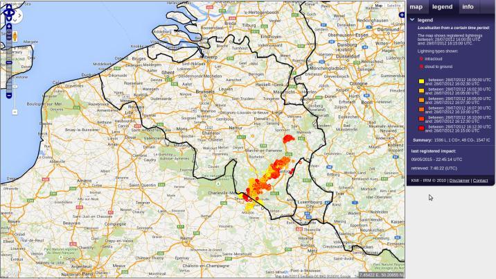
38 38 16:15
39 39 16:30
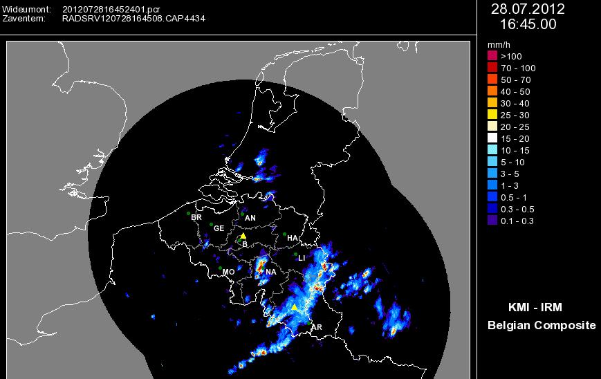
40 40 16:45
41 41 17:00
42 42 17:15
43 43 17:30
44 44 17:45
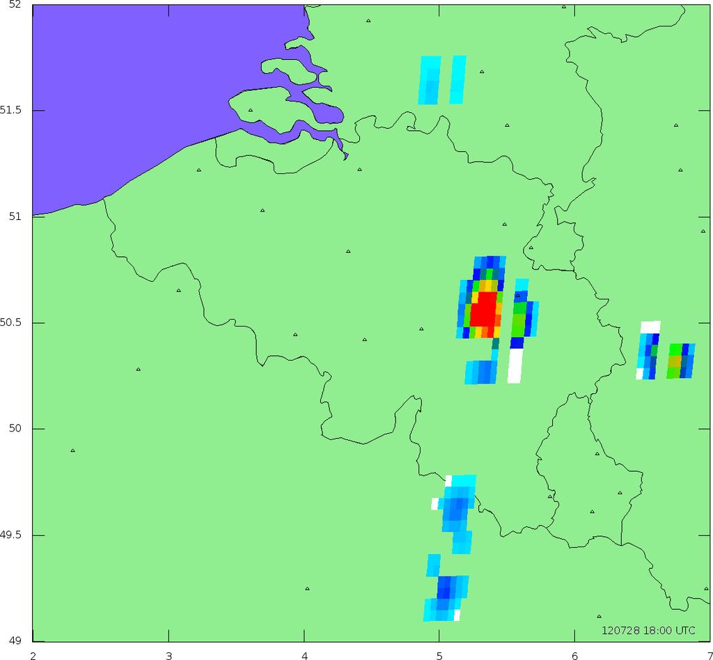
45 45 18:00
46 46 18:15
47 47 18:30
48 48 18:45
49 49 19:00
50 50 19:15
51 51 19:30
52 Topics Putting Meteosat Third Generation (MTG) into context Lightning monitoring from space how does the concept work MTG Lightning Imager Design and characteristics User products Proxy data development Summary 52
53 Summary The Lightning Imager is a new mission on Meteosat Third Generation, with no heritage in Europe (first GEO mission will be on GOES-R in 2016) (almost) Full disk coverage with 4 different detectors Homogeneous and continuous observations of lightning flashes with a timeliness of 30 seconds To be launched in 2019 User products consist of Initial processing data (groups and flashes) Accumulated product data Proxy data for LI available from 2015 onwards (continuous development) 53
EUMETSAT Satellite Programmes Use of McIDAS at EUMETSAT
 EUMETSAT Satellite Programmes Use of McIDAS at EUMETSAT Marianne König Peter Miu McIDAS Users' Group Meeting, 07-10 May 2012 Slide 1 EUMETSAT Headquarters Darmstadt McIDAS Users' Group Meeting, 07-10 May
EUMETSAT products and services for monitoring storms - New missions, more data and more meteorological products
 EUMETSAT products and services for monitoring storms - New missions, more data and more meteorological products Jochen Grandell 1 EUM/RSP/VWG/17/921460 Outline Overview of EUMETSAT missions Current...and
Status of EUMETSAT Current and Future Programmes
 Status of EUMETSAT Current and Future Programmes Ernst Koenemann Director Programme Development Spanish Industry Day 15 th Slide: 1 Brief Status of MSG and EPS All operational Missions are performing as
MSG system over view
 MSG system over view 1 Introduction METEOSAT SECOND GENERATION Overview 2 MSG Missions and Services 3 The SEVIRI Instrument 4 The MSG Ground Segment 5 SAF Network 6 Conclusions METEOSAT SECOND GENERATION
EUMETSAT Satellite Programmes Use of McIDAS at EUMETSAT
 EUMETSAT Satellite Programmes Use of McIDAS at EUMETSAT Sauli Joro Remote Sensing Expert Peter Miu Data Services Operations Engineer Slide: 1 EUMETSAT Headquarters Darmstadt Slide: 2 Location of EUMETSAT
Meteosat Third Generation. The Future European Geostationary Meteorological Satellite
 Meteosat Third Generation The Future European Geostationary Meteorological Satellite Meteosat Third Generation Jean-Loup Bézy, Donny Aminou & Paolo Bensi Future Programmes Department, ESA Directorate of
GENERATION OF HIMAWARI-8 AMVs USING THE FUTURE MTG AMV PROCESSOR
 GENERATION OF HIMAWARI-8 AMVs USING THE FUTURE MTG AMV PROCESSOR Manuel Carranza 1, Régis Borde 2, Masahiro Hayashi 3 1 GMV Aerospace and Defence S.A. at EUMETSAT, Eumetsat Allee 1, D-64295 Darmstadt,
METEOSAT THIRD GENERATION
 METEOSAT THIRD GENERATION FACTS AND FIGURES MONITORING WEATHER AND CLIMATE FROM SPACE A HIGHLY INNOVATIVE GEOSTATIONARY SATELLITE SYSTEM FOR EUROPE AND AFRICA The Meteosat Third Generation (MTG) system
EUMETSAT NEWS. Marianne König.
 EUMETSAT NEWS Marianne König marianne.koenig@eumetsat.int www.eumetsat.int MUG 2010 26 Member States & 5 Cooperating States * Member States AUSTRIA BELGIUM CROATIA CZECH REPUBLIC DENMARK FINLAND FRANCE
EUMETSAT PLANS. K. Dieter Klaes EUMETSAT Darmstadt, Germany
 EUMETSAT PLANS K. Dieter Klaes EUMETSAT Darmstadt, Germany 1. INTRODUCTION The European Organisation for the Exploitation of Meteorological Satellites (EUMETSAT), contributes to the World Weather Watch
Present Status and Future Capabilities of Ground-Based Lightning Networks
 Present Status and Future Capabilities of Ground-Based Lightning Networks Presentation for the MTG Mission Team Jochen Grandell 6 March 2007 Slide: 1 TOPICS OF THE PRESENTATION Background for the study
Improving real time observation and nowcasting RDT. E de Coning, M Gijben, B Maseko and L van Hemert Nowcasting and Very Short Range Forecasting
 Improving real time observation and nowcasting RDT E de Coning, M Gijben, B Maseko and L van Hemert Nowcasting and Very Short Range Forecasting Introduction Satellite Application Facilities (SAFs) are
The Copernicus Sentinel-5 Mission: Daily Global Data for Air Quality, Climate and Stratospheric Ozone Applications
 SENTINEL-5 The Copernicus Sentinel-5 Mission: Daily Global Data for Air Quality, Climate and Stratospheric Ozone Applications Yasjka Meijer RHEA for ESA, Noordwijk, NL 15/04/2016 Co-Authors: Jörg Langen,
EUMETSAT Satellite Status
 EUMETSAT Satellite Status Dr. K. Dieter Klaes EUMETSAT 1 ET-SAT Meeting 4-6 April 2017, WMO, Geneva, Switzerland EUMETSAT is an intergovernmental organisation with 30 Member States and 1 Cooperating State
Lightning Detection Systems
 Lightning Detection Systems Roger Carter, Spectrum Manager, UK Met Office ITU/WMO SEMINAR ON USE OF RADIO SPECTRUM FOR METEOROLOGY. 16 18 September 2009 Lightning Detection Systems Table of Contents Introduction
Status report on current and future satellite systems by EUMETSAT Presented to CGMS-44, Plenary session, agenda item D.1
 Status report on current and future satellite systems by EUMETSAT Presented to CGMS-44, Plenary session, agenda item D.1 CGMS-44-EUMETSAT-WP-19.ppt, version 1 (# 859110), 8 June 2016 MISSION PLANNING YEAR...
EUMETSAT SAF NETWORK. Lothar Schüller, EUMETSAT SAF Network Manager
 1 EUMETSAT SAF NETWORK Lothar Schüller, EUMETSAT SAF Network Manager EUMETSAT ground segment overview METEOSAT JASON-2 INITIAL JOINT POLAR SYSTEM METOP NOAA SATELLITES CONTROL AND DATA ACQUISITION FLIGHT
Visualizing Geostationary Lightning Mapper Data
 Visualizing Geostationary Lightning Mapper Data Scott D. Rudlosky NOAA/NEDIS/STAR University of Maryland College Park, MD, USA scott.rudlosky@noaa.gov Michael J. Peterson Earth System Science Interdisciplinary
THE ATMOSPHERIC MOTION VECTOR RETRIEVAL SCHEME FOR METEOSAT SECOND GENERATION. Kenneth Holmlund. EUMETSAT Am Kavalleriesand Darmstadt Germany
 THE ATMOSPHERIC MOTION VECTOR RETRIEVAL SCHEME FOR METEOSAT SECOND GENERATION Kenneth Holmlund EUMETSAT Am Kavalleriesand 31 64293 Darmstadt Germany ABSTRACT The advent of the Meteosat Second Generation
The Sentinel-4 Mission and its Atmospheric Composition Products
 This image cannot currently be displayed. The Sentinel-4 Mission and its Atmospheric Composition Products Ben Veihelmann, Yasjka Meijer, Jörg Langen, Paul Ingmann, Rob Koopman, Norrie Wright, Grégory Bazalgette
Remote Sensing in Meteorology: Satellites and Radar. AT 351 Lab 10 April 2, Remote Sensing
 Remote Sensing in Meteorology: Satellites and Radar AT 351 Lab 10 April 2, 2008 Remote Sensing Remote sensing is gathering information about something without being in physical contact with it typically
MTG-IRS processing overview and performances. Dorothee Coppens and Bertrand Theodore
 MTG-IRS processing overview and performances Dorothee Coppens and Bertrand Theodore 1 ITSC-XXI conference, Darmstadt, 29 Nov 5 Dec 2017 Outlines 1) Overview of MTG mission and IRS instrument 2) Overview
OPERATIONAL USE OF METEOSAT-8 SEVIRI DATA AND DERIVED NOWCASTING PRODUCTS. Nataša Strelec Mahović
 OPERATIONAL USE OF METEOSAT-8 SEVIRI DATA AND DERIVED NOWCASTING PRODUCTS Nataša Strelec Mahović Meteorological and Hydrological Service Grič 3, 10 000 Zagreb, Croatia strelec@cirus.dhz.hr ABSTRACT Meteosat-8
SATELLITE MONITORING OF THE CONVECTIVE STORMS
 SATELLITE MONITORING OF THE CONVECTIVE STORMS FORECASTERS POINT OF VIEW Michaela Valachová, EUMETSAT Workshop at ECMWF User Meeting Reading, 13 June 2017 Central Forecasting Office, Prague michaela.valachova@chmi.cz
MSG Indian Ocean Data Coverage (IODC) Jochen Grandell & Sauli Joro
 Jochen Grandell & Sauli Joro") MSG Indian Ocean Data Coverage (IODC) Jochen Grandell & Sauli Joro 1 EUM/STG-SWG/42/17/VWG/03 v1, 7 8 Mach 2017 Topics Introduction MSG-IODC Overall Project Schedule Status Product validation Products
MSG Indian Ocean Data Coverage (IODC) Jochen Grandell & Sauli Joro 1 EUM/STG-SWG/42/17/VWG/03 v1, 7 8 Mach 2017 Topics Introduction MSG-IODC Overall Project Schedule Status Product validation Products
Satellite observation of atmospheric dust
 Satellite observation of atmospheric dust Taichu Y. Tanaka Meteorological Research Institute, Japan Meteorological Agency 11 April 2017, SDS WAS: Dust observation and modeling @WMO, Geneva Dust observations
MSGVIEW: AN OPERATIONAL AND TRAINING TOOL TO PROCESS, ANALYZE AND VISUALIZATION OF MSG SEVIRI DATA
 MSGVIEW: AN OPERATIONAL AND TRAINING TOOL TO PROCESS, ANALYZE AND VISUALIZATION OF MSG SEVIRI DATA Aydın Gürol Ertürk Turkish State Meteorological Service, Remote Sensing Division, CC 401, Kalaba Ankara,
THE EUMETSAT SATELLITE PROGRAMMES AN OVERVIEW FROM NOW TO THE FUTURE
 THE EUMETSAT SATELLITE PROGRAMMES AN OVERVIEW FROM NOW TO THE FUTURE Kenneth Holmlund EUMETSAT And many other contributors from EUMETSAT and its partners Current EUMETSAT satellite fleet METOP -A and -B
The ESA Earth observation programmes overview and outlook
 The ESA Earth observation programmes overview and outlook Dr. Volker Liebig Director, ESA EO Programmes ILA 2008, Berlin ENVISAT mission: 6 years! Bam earthquake Tectonic uplift (Andaman) Arctic 2007 First
PRECONVECTIVE SOUNDING ANALYSIS USING IASI AND MSG- SEVIRI
 PRECONVECTIVE SOUNDING ANALYSIS USING IASI AND MSG- SEVIRI Marianne König, Dieter Klaes EUMETSAT, Eumetsat-Allee 1, 64295 Darmstadt, Germany Abstract EUMETSAT operationally generates the Global Instability
EARS-ATMS, EARS-CrIS and EARS-VIIRS: Three New Regional Services
 EARS-, EARS- and EARS-VIIRS: Three New Regional Services Anders Meier Soerensen, Ester Rojo, Thomas Heinemann, Michele Burla, Susanne Dieterle EUMETSAT Monitoring weather and climate from space Meteosat-7
H-SAF future developments on Convective Precipitation Retrieval
 H-SAF future developments on Convective Precipitation Retrieval Francesco Zauli 1, Daniele Biron 1, Davide Melfi 1, Antonio Vocino 1, Massimiliano Sist 2, Michele De Rosa 2, Matteo Picchiani 2, De Leonibus
Promising results for lightning predictions
 from Newsletter Number 155 Spring 2018 METEOROLOGY Promising results for lightning predictions Cover image: mishoo/istock/thinkstock doi:10.21957/plz731tyg2 This article appeared in the Meteorology section
EUMETSAT AGENCY REPORT 2014/15 INSTRUMENT CAL/VAL ACTIVITIES
 1 WGCV Plenary #39, Berlin, May 2015 EUMETSAT AGENCY REPORT 2014/15 INSTRUMENT CAL/VAL ACTIVITIES J. Ackermann, S. Elliott, T. Hewison, K. Holmlund, V. John, R. Munro, P. Miu, A. O Carroll, R. Roebeling,
EUMETSAT s activities in support of precipitation remote sensing
 EUMETSAT s activities in support of precipitation remote sensing Thomas Heinemann Slide: 1 Overview Precipitation remote sensing: linking science and operations Transfer of algorithms to the operational
Cloud analysis from METEOSAT data using image segmentation for climate model verification
 Cloud analysis from METEOSAT data using image segmentation for climate model verification R. Huckle 1, F. Olesen 2 Institut für Meteorologie und Klimaforschung, 1 University of Karlsruhe, 2 Forschungszentrum
An Update on EUMETSAT Programmes and Plans. Dieter Klaes on behalf of EUMETSAT teams
 An Update on EUMETSAT Programmes and Plans Dieter Klaes on behalf of EUMETSAT teams 1 21 st International TOVS Study Conference (ITSC), Darmstadt, Germany, 29 November 2017 5 December 2017 Current EUMETSAT
Judit Kerényi. OMSZ - Hungarian Meteorological Service, Budapest, Hungary. H-1525 Budapest, P.O.Box 38, Hungary.
 SATELLITE-DERIVED PRECIPITATION ESTIMATIONS DEVELOPED BY THE HYDROLOGY SAF PROJECT CASE STUDIES FOR THE INVESTIGATION OF THEIR ACCURACY AND FEATURES IN HUNGARY Judit Kerényi OMSZ - Hungarian Meteorological
Judit Kerényi. OMSZ-Hungarian Meteorological Service P.O.Box 38, H-1525, Budapest Hungary Abstract
 Comparison of the precipitation products of Hydrology SAF with the Convective Rainfall Rate of Nowcasting-SAF and the Multisensor Precipitation Estimate of EUMETSAT Judit Kerényi OMSZ-Hungarian Meteorological
VWG.01 EUMETSAT Corporate Slide Collection (EUM/CIS/VWG/14/743878) Version 1, January 2014 MONITORING WEATHER AND CLIMATE FROM SPACE
 Version 1, January 2014 MONITORING WEATHER AND CLIMATE FROM SPACE") 1 VWG.01 EUMETSAT Corporate Slide Collection (EUM/CIS/VWG/14/743878) Version 1, January 2014 MONITORING WEATHER AND CLIMATE FROM SPACE Royal charter: 25/26 October 1859 From observation to decision making:
1 VWG.01 EUMETSAT Corporate Slide Collection (EUM/CIS/VWG/14/743878) Version 1, January 2014 MONITORING WEATHER AND CLIMATE FROM SPACE Royal charter: 25/26 October 1859 From observation to decision making:
Lightning Imaging Sensor (LIS) on ISS and Plans for Sustained Ground Measurements in Support of GLM Cal/Val
 on ISS and Plans for Sustained Ground Measurements in Support of GLM Cal/Val") Lightning Imaging Sensor (LIS) on ISS and Plans for Sustained Ground Measurements in Support of GLM Cal/Val Presented by Richard Blakeslee NASA/Marshall Space Flight Center Joint MTG LI Mission Advisory
Lightning Imaging Sensor (LIS) on ISS and Plans for Sustained Ground Measurements in Support of GLM Cal/Val Presented by Richard Blakeslee NASA/Marshall Space Flight Center Joint MTG LI Mission Advisory
Arctic Weather Every 10 Minutes: Design & Operation of ABI for PCW
 Arctic Weather Every 10 Minutes: Design and Operation of ABI for PCW Dr. Paul C. Griffith and Sue Wirth 31st Space Symposium, Technical Track, Colorado Springs, Colorado This document is not subject to
EUMETSAT Plans. K. Dieter Klaes EUMETSAT Am Kavalleriesand 31 D Darmstadt Germany. Abstract. Introduction. Programmatic Aspects
 EUMETSAT Plans K. Dieter Klaes EUMETSAT Am Kavalleriesand 31 D-64295 Darmstadt Germany Abstract This paper provides a summary on EUMETSAT current and planned programmes. EUMETSAT is currently developing,
Saviz Sehatkashani Atmospheric Science and Meteorological Research Center(ASMERC)
") Saviz Sehatkashani Atmospheric Science and Meteorological Research Center(ASMERC) Sehat.s@asmerc.ac.ir Ahwaz,2011 1 Background Chad-2004 by Jahi-Chikwendiu World Press Prize 2004 (de Graaf, 2006) 2 Background
Saviz Sehatkashani Atmospheric Science and Meteorological Research Center(ASMERC) Sehat.s@asmerc.ac.ir Ahwaz,2011 1 Background Chad-2004 by Jahi-Chikwendiu World Press Prize 2004 (de Graaf, 2006) 2 Background
RDT-CW: TOWARD A MULTIDIMENSIONAL DESCRIPTION OF CONVECTION
 RDT-CW: TOWARD A MULTIDIMENSIONAL DESCRIPTION OF CONVECTION Jean-Marc Moisselin, Frederic Autonès Météo-France, DPREVI/PI, 42 avenue G. Coriolis 31057 Toulouse, France Abstract RDT-CW (Rapid Development
EUMETSAT SAF NETWORK. Lothar Schüller, EUMETSAT SAF Network Manager
 1 EUMETSAT SAF NETWORK Lothar Schüller, EUMETSAT SAF Network Manager EUMETSAT ground segment overview METEOSAT JASON-2 INITIAL JOINT POLAR SYSTEM METOP NOAA SATELLITES CONTROL AND DATA ACQUISITION FLIGHT
The In-Orbit Commissioning of MSG-1
 Earth Observation The In-Orbit Commissioning of MSG-1 MSG Project Team, Earth Observation Projects Department, ESA Directorate of Earth Observation, ESTEC, Noordwijk, The Netherlands 80 esa bulletin 114
Atmospheric Motion Vectors: Product Guide
 Atmospheric Motion Vectors: Product Guide Doc.No. Issue : : EUM/TSS/MAN/14/786435 v1a EUMETSAT Eumetsat-Allee 1, D-64295 Darmstadt, Germany Tel: +49 6151 807-7 Fax: +49 6151 807 555 Date : 9 April 2015
THE EUMETSAT MULTI-SENSOR PRECIPITATION ESTIMATE (MPE)
") THE EUMETSAT MULTI-SENSOR PRECIPITATION ESTIMATE (MPE) Thomas Heinemann, Alessio Lattanzio and Fausto Roveda EUMETSAT Am Kavalleriesand 31, 64295 Darmstadt, Germany ABSTRACT The combination of measurements
THE EUMETSAT MULTI-SENSOR PRECIPITATION ESTIMATE (MPE) Thomas Heinemann, Alessio Lattanzio and Fausto Roveda EUMETSAT Am Kavalleriesand 31, 64295 Darmstadt, Germany ABSTRACT The combination of measurements
Nowcasting thunderstorms for aeronautical end-users
 Nowcasting thunderstorms for aeronautical end-users Jean-Marc Moisselin Météo-France, Nowcasting Department co-authors: Céline Jauffret (Météo-France) Overview Introduction SAT RADAR NWP image crédit:
A HIGH RESOLUTION EUROPEAN CLOUD CLIMATOLOGY FROM 15 YEARS OF NOAA/AVHRR DATA
 A HIGH RESOLUTION EUROPEAN CLOUD CLIMATOLOGY FROM 15 YEARS OF NOAA/AVHRR DATA R. Meerkötter 1, G. Gesell 2, V. Grewe 1, C. König 1, S. Lohmann 1, H. Mannstein 1 Deutsches Zentrum für Luft- und Raumfahrt
Cross-calibration of Geostationary Satellite Visible-channel Imagers Using the Moon as a Common Reference
 Cross-calibration of Geostationary Satellite Visible-channel Imagers Using the Moon as a Common Reference Thomas C. Stone U.S. Geological Survey, Flagstaff AZ, USA 27 30 August, 2012 Motivation The archives
CHARACTERISATION OF STORM SEVERITY BY USE OF SELECTED CONVECTIVE CELL PARAMETERS DERIVED FROM SATELLITE DATA
 CHARACTERISATION OF STORM SEVERITY BY USE OF SELECTED CONVECTIVE CELL PARAMETERS DERIVED FROM SATELLITE DATA Piotr Struzik Institute of Meteorology and Water Management, Satellite Remote Sensing Centre
Meteorological Missions
 Meteorological Missions Guido Levrini ESA GSC Space Segment Programme Manager Page 1 Introduction ESA initiated Europe s entry into satellite meteorology with the development and launch of the first Meteosat
Satellite-based thunderstorm tracking, monitoring and nowcasting over South Africa
 Satellite-based thunderstorm tracking, monitoring and nowcasting over South Africa Caroline Forster 1, Estelle de Coning 2, Sebastian Diebel 1, Tobias Zinner 3 EUMETSAT Meteorological Satellite Conference
Updates on Chinese Meteorological Satellite Programs
 6 th Asia/Oceania Meteorological Satellite Users Conference Updates on Chinese Meteorological Satellite Programs Caiying Wei Deputy director-general of NSMC National Satellite Meteorological Center (NSMC)
Status of the Sentinel-5 Precursor Presented by C. Zehner S5p, S4, and S5 Missions Manager - ESA
 Status of the Sentinel-5 Precursor Presented by C. Zehner S5p, S4, and S5 Missions Manager - ESA European response to global needs: to manage the environment, to mitigate the effects of climate change
ATMOSPHERIC MOTION VECTORS DERIVED FROM MSG RAPID SCANNING SERVICE DATA AT EUMETSAT
 ATMOSPHERIC MOTION VECTORS DERIVED FROM MSG RAPID SCANNING SERVICE DATA AT EUMETSAT Manuel Carranza 1, Arthur de Smet 2, Jörgen Gustafsson 2 1 GMV Aerospace and Defence S.A. at EUMETSAT, Eumetsat-Allee
Land Surface Temperature in the EUMETSAT LSA SAF: Current Service and Perspectives. Isabel Trigo
 Land Surface Temperature in the EUMETSAT LSA SAF: Current Service and Perspectives Isabel Trigo Outline EUMETSAT Land-SAF: Land Surface Temperature Geostationary Service SEVIRI Polar-Orbiter AVHRR/Metop
Current Status of EUMETSAT satellite missions
 Current Status of EUMETSAT satellite missions Ken Holmlund Meteorological Operations Division Kenneth.holmlund@eumetsat.int PSTG-2 12 14 June, Geneva, Switzerland Content of talk: EUMETSAT Polar System
Satellite-based Convection Nowcasting and Aviation Turbulence Applications
 Satellite-based Convection Nowcasting and Aviation Turbulence Applications Kristopher Bedka Cooperative Institute for Meteorological Satellite Studies (CIMSS), University of Wisconsin-Madison In collaboration
RGB Experts and Developers Workshop - Introduction Tokyo, Japan 7-9 Nov 2017
 RGB Experts and Developers Workshop - Introduction Tokyo, Japan 7-9 Nov 2017 Workshop Objectives Review of existing RGB standards Reconfirm and extend existing standards (new multi-spectral imagers) Stimulate
THE EUMETSAT SATELLITE PROGRAMMES. Kenneth Holmlund EUMETSAT. R. Stuhlmann, P. Schlüssel, AN OVERVIEW FROM NOW TO THE FUTURE
 THE EUMETSAT SATELLITE PROGRAMMES AN OVERVIEW FROM NOW TO THE FUTURE Kenneth Holmlund EUMETSAT R. Stuhlmann, P. Schlüssel, D. Klaes, R. Munro, F. Montagner, J. Grandell, C. Hanson S. Rota, M. Cohen And
REPORT ON THE ACTIVITIES OF THE EUMETSAT-ESSL CONVECTION WORKING GROUP
 REPORT ON THE ACTIVITIES OF THE EUMETSAT-ESSL CONVECTION WORKING GROUP Marianne König EUMETSAT, Eumetsat Allee 1, 64295 Darmstadt, Germany Abstract The focus of the Convection Working Group is to have
FUTURE PLAN AND RECENT ACTIVITIES FOR THE JAPANESE FOLLOW-ON GEOSTATIONARY METEOROLOGICAL SATELLITE HIMAWARI-8/9
 FUTURE PLAN AND RECENT ACTIVITIES FOR THE JAPANESE FOLLOW-ON GEOSTATIONARY METEOROLOGICAL SATELLITE HIMAWARI-8/9 Toshiyuki Kurino Japan Meteorological Agency, 1-3-4 Otemachi Chiyodaku, Tokyo 100-8122,
Rapidly Developing Thunderstorm (RDT)
") Rapidly Developing Thunderstorm (RDT) Jean-Marc Moisselin, Frédéric Autones Météo-France Nowcasting Department 42, av. Gaspard Coriolis 31057 Toulouse France jean-marc.moisselin@meteo.fr EUMETRAIN Convection
Rapidly Developing Thunderstorm (RDT) Jean-Marc Moisselin, Frédéric Autones Météo-France Nowcasting Department 42, av. Gaspard Coriolis 31057 Toulouse France jean-marc.moisselin@meteo.fr EUMETRAIN Convection
Simulated MSG SEVIRI Imagery from HARMONIE-AROME
 Simulated MSG SEVIRI Imagery from HARMONIE-AROME Angeles Hernandez, AEMET Joint 28th ALADIN Workshop & HIRLAM All-Staff Meeting 2018 - Toulouse, 16-20 Apr 2018 Outline 1. Simulated Satellite Images (SSI)
A statistical approach for rainfall confidence estimation using MSG-SEVIRI observations
 A statistical approach for rainfall confidence estimation using MSG-SEVIRI observations Elisabetta Ricciardelli*, Filomena Romano*, Nico Cimini*, Frank Silvio Marzano, Vincenzo Cuomo* *Institute of Methodologies
Climate & Earth System Science. Introduction to Meteorology & Climate. Chapter 05 SOME OBSERVING INSTRUMENTS. Instrument Enclosure.
 Climate & Earth System Science Introduction to Meteorology & Climate MAPH 10050 Peter Lynch Peter Lynch Meteorology & Climate Centre School of Mathematical Sciences University College Dublin Meteorology
Hail nowcast exploiting radar and satellite observations
 Federal Department of Home Affairs FDHA Federal Office of Meteorology and Climatology MeteoSwiss Hail nowcast exploiting radar and satellite observations Ulrich Hamann, Elena Leonarduzzi, Kristopher Bedka,
Global Instability Index: Product Guide
 Doc.No. Issue : : EUM/TSS/MAN/15/802106 v1c e-signed EUMETSAT Eumetsat-Allee 1, D-64295 Darmstadt, Germany Tel: +49 6151 807-7 Fax: +49 6151 807 555 Date : 2 September 2015 http://www.eumetsat.int WBS/DBS
The GOES-R Rainfall Rate, Rainfall Potential, and Probability of Rainfall Algorithms
 The GOES-R Rainfall Rate, Rainfall Potential, and Probability of Rainfall Algorithms Bob Kuligowski, NOAA/NESDIS/STAR Yaping Li, Zhihua Zhang, Richard Barnhill, I. M. Systems Group 5 th International Precipitation
Nowcasting of Severe Weather from Satellite Images (for Southern
 Nowcasting of Severe Weather from Satellite Images (for Southern Europe) Petra Mikuš Jurković Forecasting/ nowcasting of convective storms NWP models cannot well predict the exact location and intesity
GEOMETRIC CLOUD HEIGHTS FROM METEOSAT AND AVHRR. G. Garrett Campbell 1 and Kenneth Holmlund 2
 GEOMETRIC CLOUD HEIGHTS FROM METEOSAT AND AVHRR G. Garrett Campbell 1 and Kenneth Holmlund 2 1 Cooperative Institute for Research in the Atmosphere Colorado State University 2 EUMETSAT ABSTRACT Geometric
Lecture 4b: Meteorological Satellites and Instruments. Acknowledgement: Dr. S. Kidder at Colorado State Univ.
 Lecture 4b: Meteorological Satellites and Instruments Acknowledgement: Dr. S. Kidder at Colorado State Univ. US Geostationary satellites - GOES (Geostationary Operational Environmental Satellites) US
An illustration of the practical use in aviation of operational real-time geostationary satellite data
 An illustration of the practical use in aviation of operational real-time geostationary satellite data Jos de Laat # and Jan-Fokke Meirink Royal Netherlands Meteorological Institute operational use of
Preparation for FY-4A. (Submitted by Xiang Fang, CMA)
") WORLD METEOROLOGICAL ORGANIZATION COMMISSION FOR BASIC SYSTEMS OPEN PROGRAMME AREA GROUP ON INTEGRATED OBSERVING SYSTEMS EXPERT TEAM ON SATELLITE UTILIZATION AND PRODUCTS ET-SUP-8/Doc. 10.3 (2.IV.2014)
WORLD METEOROLOGICAL ORGANIZATION COMMISSION FOR BASIC SYSTEMS OPEN PROGRAMME AREA GROUP ON INTEGRATED OBSERVING SYSTEMS EXPERT TEAM ON SATELLITE UTILIZATION AND PRODUCTS ET-SUP-8/Doc. 10.3 (2.IV.2014)
GLM INR and Instrument Performance Evaluation
 GLM INR and Instrument Performance Evaluation Presented by Dennis Buechler University of Alabama in Huntsville Joint MTG LI Mission Advisory Group & GOES-R GLM Science Team Workshop, Rome Italy 27-29 May
Future mission : IASI-new generation
 Future mission : IASI-new generation Signal/noise Spectral resolution Pixel size IASI IASI-NG Cathy Clerbaux What s next? IASI-NG (IASI-New Generation) IASI and IASI-NG spectrum Averaged over the
A Guide to Satellite Data Appropriate for Solar Energy Applications in Ireland
 University College Dublin Satellite Data A Guide to Satellite Data Appropriate for Solar Energy Applications in Ireland Eadaoin Doddy eadaoin.doddy@ucdconnect.ie 13 January 2017 Contents 1 Satellites 1
EUMETSAT Data and Services for Climate Services and Research. Jörg Schulz
 EUMETSAT Data and Services for Climate Services and Research Jörg Schulz 1 WMO Workshop on Operational Space-based Weather and Climate Extremes Monitoring, WMO HQ, Geneva, Switzerland, 15-17 February 2017
Instrument Calibration Issues: Geostationary Platforms
 Instrument Calibration Issues: Geostationary Platforms Ken Holmlund EUMETSAT kenneth.holmlund@eumetsat.int Abstract The main products derived from geostationary satellite data and used in Numerical Weather
Applications of multi-spectral satellite data
 Applications of multi-spectral satellite data Jochen Kerkmann EUMETSAT, Satellite Meteorologist, Training Officer Adjusted by E de Coning South African Weather Service Content 1. Why should we use RGBs?
Interpretation of Polar-orbiting Satellite Observations. Atmospheric Instrumentation
 Interpretation of Polar-orbiting Satellite Observations Outline Polar-Orbiting Observations: Review of Polar-Orbiting Satellite Systems Overview of Currently Active Satellites / Sensors Overview of Sensor
Vaisala Blitzdetektion. Michael Kalkum
 Vaisala Blitzdetektion Michael Kalkum 12.11.2013 What Is Lightning? Lightning is a transient, high-current electrical discharge Lightning stroke is typically 30.000 C Lightning takes the path of least
The importance of satellite data for nowcasting in the WWRP strategy
 The importance of satellite data for nowcasting in the WWRP strategy Estelle de Coning and Paolo Ruti World Weather Research Division Steve Goodman Chief Program Scientist, NOAA WMO definition Nowcasting
Back to basics: From Sputnik to Envisat, and beyond: The use of satellite measurements in weather forecasting and research: Part 1 A history
 Back to basics: From Sputnik to Envisat, and beyond: The use of satellite measurements in weather forecasting and research: Part 1 A history Roger Brugge 1 and Matthew Stuttard 2 1 NERC Data Assimilation
An Eye in the Sky EUMETSAT. Monitoring Weather, Climate and the Environment
 An Eye in the Sky EUMETSAT Monitoring Weather, Climate and the Environment Slide: 1 Hazardous Weather Slide: 2 Hazardous Weather Slide: 3 Natural Disasters set off by severe weather Slide: 4 EUMETSAT Objectives...
The LSA-SAF Albedo products
 The LSA-SAF Albedo products G. Jacob, D. Carrer & J.-L. Roujean CNRM-GAME, Météo France, Toulouse 2 Outline Method for retrieval Theoretical Framework Available Input BRDF Inversion Algorithm overview
Operational systems for SST products. Prof. Chris Merchant University of Reading UK
 Operational systems for SST products Prof. Chris Merchant University of Reading UK Classic Images from ATSR The Gulf Stream ATSR-2 Image, ƛ = 3.7µm Review the steps to get SST using a physical retrieval
Instrumentation planned for MetOp-SG
 Instrumentation planned for MetOp-SG Bill Bell Satellite Radiance Assimilation Group Met Office Crown copyright Met Office Outline Background - the MetOp-SG programme The MetOp-SG instruments Summary Acknowledgements:
VALIDATION RESULTS OF THE OPERATIONAL LSA-SAF SNOW COVER MAPPING
 VALIDATION RESULTS OF THE OPERATIONAL LSA-SAF SNOW COVER MAPPING Niilo Siljamo, Otto Hyvärinen Finnish Meteorological Institute, Erik Palménin aukio 1, P.O.Box 503, FI-00101 HELSINKI Abstract Hydrological
STATUS OF JAPANESE METEOROLOGICAL SATELLITES AND RECENT ACTIVITIES OF MSC
 STATUS OF JAPANESE METEOROLOGICAL SATELLITES AND RECENT ACTIVITIES OF MSC Daisaku Uesawa Meteorological Satellite Center, Japan Meteorological Agency Abstract MTSAT-1R is the current operational Japanese
STATUS AND DEVELOPMENT OF OPERATIONAL METEOSAT WIND PRODUCTS. Mikael Rattenborg. EUMETSAT, Am Kavalleriesand 31, D Darmstadt, Germany ABSTRACT
 STATUS AND DEVELOPMENT OF OPERATIONAL METEOSAT WIND PRODUCTS Mikael Rattenborg EUMETSAT, Am Kavalleriesand 31, D-64295 Darmstadt, Germany ABSTRACT The Operational Meteosat Meteorological Products are produced
Study of the Influence of Thin Cirrus Clouds on Satellite Radiances Using Raman Lidar and GOES Data
 Study of the Influence of Thin Cirrus Clouds on Satellite Radiances Using Raman Lidar and GOES Data D. N. Whiteman, D. O C. Starr, and G. Schwemmer National Aeronautics and Space Administration Goddard
Global Space-based Inter-Calibration System (GSICS) Infrared Reference Sensor Traceability and Uncertainty
 Infrared Reference Sensor Traceability and Uncertainty") Global Space-based Inter-Calibration System (GSICS) Infrared Reference Sensor Traceability and Uncertainty Tim Hewison (EUMETSAT) Thomas Pagano (NASA/JPL) Dave Tobin (NOAA/CIMSS) Masaya Takahashi (JMA)
Global Space-based Inter-Calibration System (GSICS) Infrared Reference Sensor Traceability and Uncertainty Tim Hewison (EUMETSAT) Thomas Pagano (NASA/JPL) Dave Tobin (NOAA/CIMSS) Masaya Takahashi (JMA)
Retrieval of precipitation from Meteosat-SEVIRI geostationary satellite observations
 Retrieval of precipitation from Meteosat-SEVIRI geostationary satellite observations Jan Fokke Meirink, Hidde Leijnse (KNMI) Rob Roebeling (EUMETSAT) Overview Introduction Algorithm description Validation
Derivation of AMVs from single-level retrieved MTG-IRS moisture fields
 Derivation of AMVs from single-level retrieved MTG-IRS moisture fields Laura Stewart MetOffice Reading, Meteorology Building, University of Reading, Reading, RG6 6BB Abstract The potential to derive AMVs
A unified, global aerosol dataset from MERIS, (A)ATSR and SEVIRI
ATSR and SEVIRI") A unified, global aerosol dataset from MERIS, and SEVIRI Gareth Thomas gthomas@atm.ox.ac.uk Introduction GlobAEROSOL is part of the ESA Data User Element programme. It aims to provide a global aerosol
A unified, global aerosol dataset from MERIS, and SEVIRI Gareth Thomas gthomas@atm.ox.ac.uk Introduction GlobAEROSOL is part of the ESA Data User Element programme. It aims to provide a global aerosol
Outgoing Longwave Radiation Product: Product Guide
 Outgoing Longwave Radiation Product: Product Guide Doc.No. : EUM/OPS/DOC/09/5176 EUMETSAT Eumetsat-Allee 1, D-64295 Darmstadt, Germany Tel: +49 6151 807-7 Issue : v1e Fax: +49 6151 807 555 Date : 6 May