Hail nowcast exploiting radar and satellite observations
|
|
|
- Juliana Bates
- 5 years ago
- Views:
Transcription
1 Federal Department of Home Affairs FDHA Federal Office of Meteorology and Climatology MeteoSwiss Hail nowcast exploiting radar and satellite observations Ulrich Hamann, Elena Leonarduzzi, Kristopher Bedka, Nikola Besic, Lorenzo Clementi, Jordi Figueras i Ventura, Marco Gabella, Alessandro M. Hering, Andreas Leuenberger, Luca Nisi, Marco Sassi, Urs Germann
 COALITION-2 algorithm")
 MeteoSwiss radar network Lightning")
2 Outline of the talk A hail event study with different sensors Thunderstorm Radar Tracking TRT (Hering, 2015) COALITION-2 algorithm based on MSG/SEVIRI (Hamann, 2016) Overshooting Top detection based on MSG/SEVIRI (Bedka, 2010, 2016) MeteoSwiss radar network Lightning observations (Meteorage) 2

 Extrapolation of the position Tracking of various radar, satellite, lightning parameters")
3 Thunderstorm Radar Tracking TRT Primarily based on Swiss radar network 5 dual-pole Doppler radars Temporal resolution 5min Spatial resolution 1 km automated detection, tracking of radar cells Severity ranking with VIL, Echo Top Altitude(45 dbz), max. reflectivity, area (57 dbz) Extrapolation of the position Tracking of various radar, satellite, lightning parameters Hering et al, ECSS 2015, Austria Fully automated thunderstorm warnings and operational nowcasting at MeteoSwiss 3

4 COALITION-2 Primarily based on MeteoSat SEVIRI Based on 8 IR channels Temporal resolution 5min Spatial resolution 3x5 km automated detection, tracking of satellite cells Classification in early, developing and mature cells Extrapolation of the position Hamann et al, 2016 Nowcasting of thunderstorms and severe convection in Switzerland Eumetsat Conference 2016, Darmstadt, Germany 4
 optical thick clouds b) ice clouds c) updraft d) small ice crystals Inspired by Mecikalski et al, 2010, Cloud-Top Properties of Growing Cumulus prior to Convective")
5 Thunderstorm detection from MSG COALITION-2 uses brightness temperature, their spectral and temporal differences of SEVIRI channels (onboard of Meteosat Second Generation MSG) Four categories of threshold tests detect a) optical thick clouds b) ice clouds c) updraft d) small ice crystals Inspired by Mecikalski et al, 2010, Cloud-Top Properties of Growing Cumulus prior to Convective Initiation as Measured by Meteosat Second Generation. Part I: Infrared Fields 5
")
")
 c) ice clouds")
 The colours have")

6 COALITION-2 RGB product COALITION-2 RGB optical thickness (red) COALITION-2 uses the number of passed indicator tests as a) optical thick clouds (red) b) updraft (green) c) ice clouds (blue) to create a false colour composite (RGB) The colours have following meaning thick ice cloud strong updraft developing ice cloud updraft (green) glaciation (blue) 6
7 7

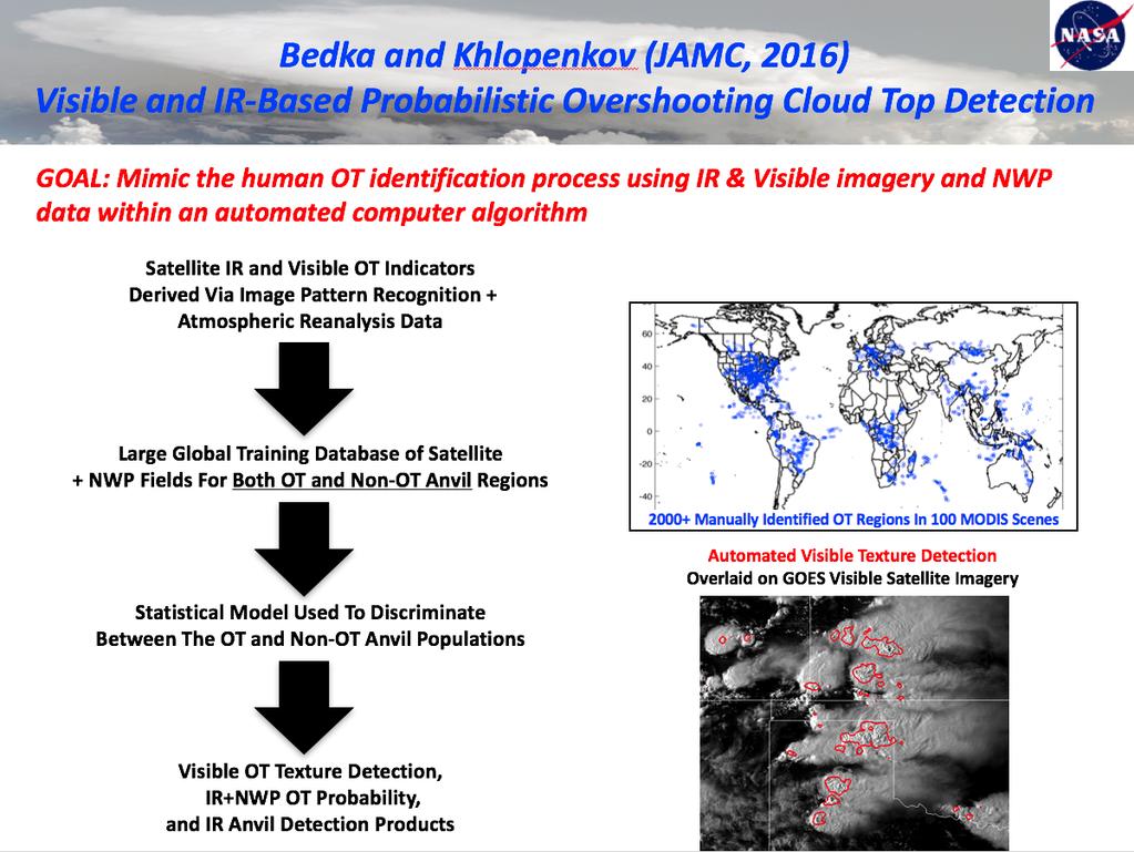
8 Badka and Khlopenkov, JAMC,


 and 0-3km")

9 Case Study 07 July 2015 Frontal systems 0-500m water mixing ratio 18UTC ML CAPE (color) and 0-3km wind shear 18UTC Estofex thunderstorm analysis + IR 18UTC 9

10 Synoptic situation COALITION2 overview RGB convection RGB Odyssey Radar precipitation The three panels show a typical example of a convective situation ( :00 18:30 UTC). The forecaster has access to information about convective activity for whole Europe. Satellite data is available each 5min. Odyssey radar composite is available each 15min. 10
11 Hail in Switzerland Maximum Expected Severe Hail Size (Treloar, 1998) Probability Of Hail (Waldvogel1979, Foote 2005 ) 11

12 Local observation in Switzerland High Resolution overview Satellite image Instantaneous Radar Rain Rate 12

13 Local observation in Switzerland High Resolution overview Satellite image Thunderstorm Radar Tracking (and Radar Rain Rate) Instantaneous Radar Rain Rate 13

14 Local observation in Switzerland High Resolution overview Satellite image COALITION-2 Instantaneous Radar Rain Rate 14

15 Local observation in Switzerland High Resolution overview MSG/SEVIRI Overshooting Top detection Bedka based on MSG/SEVIRI Instantaneous Radar Rain Rate Anvils Overshooting Tops dt(ot)>5k, p(ot)>0.7 15


>5k & p(ot)>0.")
16 Daily distribution of severe weather Overshooting Top detection Bedka dt(ot)>5k & p(ot)>0.7 Radar POH>0.0 16

17 Local observation in Switzerland COALITION-2 Satellite algorithm Overshooting Top detection Bedka dt(ot)>5k & p(ot)>0.7 High Resolution Overview Satellite image Thunderstrom Radar Tracking Instantaneous Radar Rain Rate Lightning Density / (10min 314km 2 ) 17

18 Future work Usage of hydrometeor classifications and polarimetric radar observations Besic, Nikola, et al. "Hydrometeor classification through statistical clustering of polarimetric radar measurements: a semi-supervised approach." Atmospheric Measurement Techniques 9.9 (2016):

19 Future outlook Usage of hydrometeor classifications and polarimetric radar observations 19
20 Summary Three algorithms were investigated Thunderstorm Radar Tracking (Hering, 2015) COALITION-2 (Hamann, 2016) Overshooting Top (Bedka, 2010, 2016) TRT based on radar is most direct measurement of hail COALITION-2 detects convection very early, for mature stage the detection of the anivl is not precise enough to locate hail Overshooting Tops captures severe weather very well and indicates a hail production accurately Future work Usage of polarimetric radar observation and hydrometeor classification Development of a radar-satellite algorithm combining the strengths of all three algorithms for Switzerland 20


21 21
22 22
23 Flowchart COALITION-2 Wind data NWC-SAF HRW NWP model wind MSG/SEVIRI IR 3.9 µm WV 6.2 µm WV 7.3 µm IR 8.7 µm IR 9.7 µm IR 10.8 µm IR 12.0 µm IR 13.4 µm Brightness Temperature Forecast t+15 t+30 Glaciation gi1 gi2 gi3 Cloud Depth cd1 cd5 Updraft Strength us1 us7 Convection IR3.9 IR 10.8 Part1: detection Mature Cells sum(cd) >= 4 & sum(gi) >= 2 & convective Developing Cells sum(cd) >= 4 & sum(us) >=2 & convective Post-processing Cirrus cloud removal Fill holes Remove small clouds gridded thunderstorm detection product 23
Early detection of thunderstorms using satellite, radar and
 Federal Department of Home of Home Affairs Affairs FDHA FDHA Federal Office of of Meteorology and and Climatology MeteoSwiss Early detection of thunderstorms using satellite, radar and Observing convection
A new era of hail monitoring, forecasting and climatology in Switzerland
 Federal Department of Home Affairs FDHA Federal Office of Meteorology and Climatology MeteoSwiss A new era of hail monitoring, forecasting and climatology in Switzerland Urs Germann, MeteoSwiss, Locarno-Monti
SATELLITE MONITORING OF THE CONVECTIVE STORMS
 SATELLITE MONITORING OF THE CONVECTIVE STORMS FORECASTERS POINT OF VIEW Michaela Valachová, EUMETSAT Workshop at ECMWF User Meeting Reading, 13 June 2017 Central Forecasting Office, Prague michaela.valachova@chmi.cz
REPORT ON THE ACTIVITIES OF THE EUMETSAT-ESSL CONVECTION WORKING GROUP
 REPORT ON THE ACTIVITIES OF THE EUMETSAT-ESSL CONVECTION WORKING GROUP Marianne König EUMETSAT, Eumetsat Allee 1, 64295 Darmstadt, Germany Abstract The focus of the Convection Working Group is to have
Nowcasting of Severe Weather from Satellite Images (for Southern
 Nowcasting of Severe Weather from Satellite Images (for Southern Europe) Petra Mikuš Jurković Forecasting/ nowcasting of convective storms NWP models cannot well predict the exact location and intesity
Seamless nowcasting. Open issues
 Federal Department of Home Affairs FDHA Federal Office of Meteorology and Climatology MeteoSwiss Seamless nowcasting INCA Open issues Pierre Eckert Matteo Buzzi, Marco Sassi, Guido della Bruna, Marco Gaia
Rapidly Developing Thunderstorm (RDT)
") Rapidly Developing Thunderstorm (RDT) Jean-Marc Moisselin, Frédéric Autones Météo-France Nowcasting Department 42, av. Gaspard Coriolis 31057 Toulouse France jean-marc.moisselin@meteo.fr EUMETRAIN Convection
Rapidly Developing Thunderstorm (RDT) Jean-Marc Moisselin, Frédéric Autones Météo-France Nowcasting Department 42, av. Gaspard Coriolis 31057 Toulouse France jean-marc.moisselin@meteo.fr EUMETRAIN Convection
METEOSAT CONVECTIVE INITIATION PRODUCT WITH AND WITHOUT CLOUD TRACKING - EXPERIENCES
 METEOSAT CONVECTIVE INITIATION PRODUCT WITH AND WITHOUT CLOUD TRACKING - EXPERIENCES Mária Putsay 1, Zsófia Kocsis 1, Marianne König 2, Ildikó Szenyán 1, Márta Diószeghy 1, André Simon 1 and Márk Rajnai
Warning procedures for extreme events in the Emilia-Romagna Region
 Warning procedures for extreme events in the Emilia-Romagna Region Anna Fornasiero, Miria Celano, Roberta Amorati, Virginia Poli and Pier Paolo Alberoni Arpa Emilia-Romagna Hydro-Meteo-Climate Service,
CHARACTERISATION OF STORM SEVERITY BY USE OF SELECTED CONVECTIVE CELL PARAMETERS DERIVED FROM SATELLITE DATA
 CHARACTERISATION OF STORM SEVERITY BY USE OF SELECTED CONVECTIVE CELL PARAMETERS DERIVED FROM SATELLITE DATA Piotr Struzik Institute of Meteorology and Water Management, Satellite Remote Sensing Centre
Improving real time observation and nowcasting RDT. E de Coning, M Gijben, B Maseko and L van Hemert Nowcasting and Very Short Range Forecasting
 Improving real time observation and nowcasting RDT E de Coning, M Gijben, B Maseko and L van Hemert Nowcasting and Very Short Range Forecasting Introduction Satellite Application Facilities (SAFs) are
Satellite-based Convection Nowcasting and Aviation Turbulence Applications
 Satellite-based Convection Nowcasting and Aviation Turbulence Applications Kristopher Bedka Cooperative Institute for Meteorological Satellite Studies (CIMSS), University of Wisconsin-Madison In collaboration
2.14 NOWCASTING THUNDERSTORMS IN COMPLEX CASES USING RADAR DATA
 2.14 NOWCASTING THUNDERSTORMS IN COMPLEX CASES USING RADAR DATA Alessandro M. Hering* 1, Stéphane Sénési 2, Paolo Ambrosetti 1, and Isabelle Bernard-Bouissières 2 1 MeteoSwiss, ML, Locarno-Monti, Switzerland
MSG FOR NOWCASTING - EXPERIENCES OVER SOUTHERN AFRICA
 MSG FOR NOWCASTING - EXPERIENCES OVER SOUTHERN AFRICA Estelle de Coning and Marianne König South African Weather Service, Private Bag X097, Pretoria 0001, South Africa EUMETSAT, Am Kavalleriesand 31, D-64295
Detection of convective overshooting tops using Himawari-8 AHI, CloudSat CPR, and CALIPSO data
 Detection of convective overshooting tops using Himawari-8 AHI, CloudSat CPR, and CALIPSO data Miae Kim¹, Jungho Im¹, Seonyoung Park¹ ¹Ulsan National Institute of Science and Technology (UNIST), South
Nowcasting thunderstorms for aeronautical end-users
 Nowcasting thunderstorms for aeronautical end-users Jean-Marc Moisselin Météo-France, Nowcasting Department co-authors: Céline Jauffret (Météo-France) Overview Introduction SAT RADAR NWP image crédit:
DATA FUSION NOWCASTING AND NWP
 DATA FUSION NOWCASTING AND NWP Brovelli Pascal 1, Ludovic Auger 2, Olivier Dupont 1, Jean-Marc Moisselin 1, Isabelle Bernard-Bouissières 1, Philippe Cau 1, Adrien Anquez 1 1 Météo-France Forecasting Department
SATELLITE SIGNATURES ASSOCIATED WITH SIGNIFICANT CONVECTIVELY-INDUCED TURBULENCE EVENTS
 SATELLITE SIGNATURES ASSOCIATED WITH SIGNIFICANT CONVECTIVELY-INDUCED TURBULENCE EVENTS Kristopher Bedka 1, Wayne Feltz 1, John Mecikalski 2, Robert Sharman 3, Annelise Lenz 1, and Jordan Gerth 1 1 Cooperative
Satellite-based thunderstorm tracking, monitoring and nowcasting over South Africa
 Satellite-based thunderstorm tracking, monitoring and nowcasting over South Africa Caroline Forster 1, Estelle de Coning 2, Sebastian Diebel 1, Tobias Zinner 3 EUMETSAT Meteorological Satellite Conference
RGB Experts and Developers Workshop - Introduction Tokyo, Japan 7-9 Nov 2017
 RGB Experts and Developers Workshop - Introduction Tokyo, Japan 7-9 Nov 2017 Workshop Objectives Review of existing RGB standards Reconfirm and extend existing standards (new multi-spectral imagers) Stimulate
Judit Kerényi. OMSZ - Hungarian Meteorological Service, Budapest, Hungary. H-1525 Budapest, P.O.Box 38, Hungary.
 SATELLITE-DERIVED PRECIPITATION ESTIMATIONS DEVELOPED BY THE HYDROLOGY SAF PROJECT CASE STUDIES FOR THE INVESTIGATION OF THEIR ACCURACY AND FEATURES IN HUNGARY Judit Kerényi OMSZ - Hungarian Meteorological
SUPER-RAPID SCAN SATELLITE IMAGERY ANALYSIS OF TWO HAILSTORMS SAMPLED BY HAILSTONE
 SUPER-RAPID SCAN SATELLITE IMAGERY ANALYSIS OF TWO HAILSTORMS SAMPLED BY HAILSTONE Jennifer M. Laflin* and Scott F. Blair NOAA/NWS Kansas City/Pleasant Hill, Missouri Chad Gravelle NOAA/NWS Operations
Detailed flow, hydrometeor and lightning characteristics of an isolated, hail producing thunderstorm during COPS
 Detailed flow, hydrometeor and lightning characteristics of an isolated, hail producing thunderstorm during COPS, Martin Hagen, Hartmut Höller, Hans Volkert Institut für Physik der Atmosphäre, DLR Oberpfaffenhofen
RDT-CW: TOWARD A MULTIDIMENSIONAL DESCRIPTION OF CONVECTION
 RDT-CW: TOWARD A MULTIDIMENSIONAL DESCRIPTION OF CONVECTION Jean-Marc Moisselin, Frederic Autonès Météo-France, DPREVI/PI, 42 avenue G. Coriolis 31057 Toulouse, France Abstract RDT-CW (Rapid Development
A satellite-based long-term Land Surface Temperature Climate Data Record
 Federal Department of Home Affairs FDHA Federal Office of Meteorology and Climatology MeteoSwiss A satellite-based long-term Land Surface Temperature Climate Data Record, Virgílio A. Bento, Frank M. Göttsche,
Hailstorms evidence from smart-phone users:
 Hailstorms evidence from smart-phone users: Crowd-sourced hail size data over Switzerland Noti Pascal A. Martynov, A. Hering, and O. Martius Bern 21.04.2017 Motivation & Objectives > Is crowd-sourcing
Near Real-time Cloud Classification, Mesoscale Winds, and Convective Initiation Fields from MSG Data
 Near Real-time Cloud Classification, Mesoscale Winds, and Convective Initiation Fields from MSG Data Wayne Feltz *, J. Mecikalski, and K. Bedka * Cooperative Institute of Meteorological Satellite Studies
PRECONVECTIVE SOUNDING ANALYSIS USING IASI AND MSG- SEVIRI
 PRECONVECTIVE SOUNDING ANALYSIS USING IASI AND MSG- SEVIRI Marianne König, Dieter Klaes EUMETSAT, Eumetsat-Allee 1, 64295 Darmstadt, Germany Abstract EUMETSAT operationally generates the Global Instability
P5.7 THE ADVANCED SATELLITE AVIATION WEATHER PRODUCTS (ASAP) INITIATIVE: PHASE I EFFORTS AT THE UNIVERSITY OF ALABAMA IN HUNTSVILLE
 INITIATIVE: PHASE I EFFORTS AT THE UNIVERSITY OF ALABAMA IN HUNTSVILLE") P5.7 THE ADVANCED SATELLITE AVIATION WEATHER PRODUCTS (ASAP) INITIATIVE: PHASE I EFFORTS AT THE UNIVERSITY OF ALABAMA IN HUNTSVILLE John R. Mecikalski #1, Todd A. Berendes #, U. S. Nair #, Wayne F. Feltz*,
P5.7 THE ADVANCED SATELLITE AVIATION WEATHER PRODUCTS (ASAP) INITIATIVE: PHASE I EFFORTS AT THE UNIVERSITY OF ALABAMA IN HUNTSVILLE John R. Mecikalski #1, Todd A. Berendes #, U. S. Nair #, Wayne F. Feltz*,
CASE STUDY OF THE 20 MAY 2008 TORNADIC STORM IN HUNGARY
 CASE STUDY OF THE 20 MAY 2008 TORNADIC STORM IN HUNGARY Mária Putsay 1, Jochen Kerkmann 2 and Ildikó Szenyán 1 1 Hungarian Meteorological Service, H-1525 Budapest, P. O. Box 38, Hungary 2 EUMETSAT, am
INTERPRETATION OF MSG IMAGES, PRODUCTS AND SAFNWC OUTPUTS FOR DUTY FORECASTERS
 INTERPRETATION OF MSG IMAGES, PRODUCTS AND SAFNWC OUTPUTS FOR DUTY FORECASTERS M. Putsay, M. Rajnai, M. Diószeghy, J. Kerényi, I.G. Szenyán and S. Kertész Hungarian Meteorological Service, H-1525 Budapest,
T-re Plots Generated from MSG Data in Severe Storms Forecasting Testing in Central Europe
 WDS'11 Proceedings of Contributed Papers, Part III, 88 92, 2011. ISBN 978-80-7378-186-6 MATFYZPRESS T-re Plots Generated from MSG Data in Severe Storms Forecasting Testing in Central Europe M. Pokorný
Figure 1: Tephigram for radiosonde launched from Bath at 1100 UTC on 15 June 2005 (IOP 1). The CAPE and CIN are shaded dark and light gray,
. The CAPE and CIN are shaded dark and light gray,") Figure 1: Tephigram for radiosonde launched from Bath at 1100 UTC on 1 June 200 (IOP 1). The CAPE and CIN are shaded dark and light gray, respectively; the thin solid line partially bounding these areas
Figure 1: Tephigram for radiosonde launched from Bath at 1100 UTC on 1 June 200 (IOP 1). The CAPE and CIN are shaded dark and light gray, respectively; the thin solid line partially bounding these areas
MSG system over view
 MSG system over view 1 Introduction METEOSAT SECOND GENERATION Overview 2 MSG Missions and Services 3 The SEVIRI Instrument 4 The MSG Ground Segment 5 SAF Network 6 Conclusions METEOSAT SECOND GENERATION
Application of automated CB/TCU detection based on radar and satellite data
 Application of automated CB/TCU detection based on radar and satellite data Paul de Valk, and Rudolf van Westhrenen Royal Netherlands Meteorological Institute, Ministry of Infrastruture and Environment
Judit Kerényi. OMSZ-Hungarian Meteorological Service P.O.Box 38, H-1525, Budapest Hungary Abstract
 Comparison of the precipitation products of Hydrology SAF with the Convective Rainfall Rate of Nowcasting-SAF and the Multisensor Precipitation Estimate of EUMETSAT Judit Kerényi OMSZ-Hungarian Meteorological
USE OF SATELLITE INFORMATION IN THE HUNGARIAN NOWCASTING SYSTEM
 USE OF SATELLITE INFORMATION IN THE HUNGARIAN NOWCASTING SYSTEM Mária Putsay, Zsófia Kocsis and Ildikó Szenyán Hungarian Meteorological Service, Kitaibel Pál u. 1, H-1024, Budapest, Hungary Abstract The
WG4: interpretation and applications
 Federal Department of Home Affairs FDHA Federal Office of Meteorology and Climatology MeteoSwiss WG4: interpretation and applications Pierre Eckert MeteoSwiss, Geneva Topics FIELDEXTRA presentation by
OPERATIONAL USE OF METEOSAT-8 SEVIRI DATA AND DERIVED NOWCASTING PRODUCTS. Nataša Strelec Mahović
 OPERATIONAL USE OF METEOSAT-8 SEVIRI DATA AND DERIVED NOWCASTING PRODUCTS Nataša Strelec Mahović Meteorological and Hydrological Service Grič 3, 10 000 Zagreb, Croatia strelec@cirus.dhz.hr ABSTRACT Meteosat-8
STATISTICAL ANALYSIS ON SEVERE CONVECTIVE WEATHER COMBINING SATELLITE, CONVENTIONAL OBSERVATION AND NCEP DATA
 12.12 STATISTICAL ANALYSIS ON SEVERE CONVECTIVE WEATHER COMBINING SATELLITE, CONVENTIONAL OBSERVATION AND NCEP DATA Zhu Yaping, Cheng Zhoujie, Liu Jianwen, Li Yaodong Institute of Aviation Meteorology
1.29 LIFE CYCLE OF CONVECTIVE CELLS WITH RAPID SCAN SATELLITE AND RADAR DATA IN THE EASTERN ALPINE REGION
 1.29 LIFE CYCLE OF CONVECTIVE CELLS WITH RAPID SCAN SATELLITE AND RADAR DATA IN THE EASTERN ALPINE REGION Friedrich Wölfelmaier 1, Veronika Zwatz-Meise 2 1 ZAMG, Regional center Styria, Graz, Austria,
Combining Meteosat data and weather radar products to improve the meteorological surveillance and nowcasting
 Combining Meteosat data and weather radar products to improve the meteorological surveillance and nowcasting R. Hernandez (1)(2), S. Gaztelumendi (1)(2), K. Otxoa de Alda (1)(2), I. R. Gelpi (1)(2), J.
NOWCASTING PRODUCTS BASED ON MTSAT-1R RAPID SCAN OBSERVATION. In response to CGMS Action 38.33
 CGMS-39, JMA-WP-08 Prepared by JMA Agenda Item: G.II/8 Discussed in WG II NOWCASTING PRODUCTS BASED ON MTSAT-1R RAPID SCAN OBSERVATION In response to CGMS Action 38.33 This document reports on JMA s MTSAT-1R
Rapidly Developing Cumulus Area RDCA detection using Himawari-8 data
 AOMSUC-7@Incheon Rapidly Developing Cumulus Area RDCA detection using Himawari-8 data Hiroshi SUZUE and Yasuhiko SUMIDA Meteorological Satellite Center Japan Meteorological Agency Contents Ø Outline of
EUMETSAT products and services for monitoring storms - New missions, more data and more meteorological products
 EUMETSAT products and services for monitoring storms - New missions, more data and more meteorological products Jochen Grandell 1 EUM/RSP/VWG/17/921460 Outline Overview of EUMETSAT missions Current...and
Global Instability Index: Product Guide
 Doc.No. Issue : : EUM/TSS/MAN/15/802106 v1c e-signed EUMETSAT Eumetsat-Allee 1, D-64295 Darmstadt, Germany Tel: +49 6151 807-7 Fax: +49 6151 807 555 Date : 2 September 2015 http://www.eumetsat.int WBS/DBS
Using a novel Hail Sensor to Optimize Weather Radar
 Using a novel Hail Sensor to Optimize Weather Radar By: Christian Ruckstuhl, Justin D Atri, Serge Mattli, Martin Loeffler-Mang, Dominik Schoen, Edgar Wetzel, and Urs Germann 2 World s first online network
MSGVIEW: AN OPERATIONAL AND TRAINING TOOL TO PROCESS, ANALYZE AND VISUALIZATION OF MSG SEVIRI DATA
 MSGVIEW: AN OPERATIONAL AND TRAINING TOOL TO PROCESS, ANALYZE AND VISUALIZATION OF MSG SEVIRI DATA Aydın Gürol Ertürk Turkish State Meteorological Service, Remote Sensing Division, CC 401, Kalaba Ankara,
MESO-NH cloud forecast verification with satellite observation
 MESO-NH cloud forecast verification with satellite observation Jean-Pierre CHABOUREAU Laboratoire d Aérologie, University of Toulouse and CNRS, France http://mesonh.aero.obs-mip.fr/chaboureau/ DTC Verification
Update on CoSPA Storm Forecasts
 Update on CoSPA Storm Forecasts Haig August 2, 2011 This work was sponsored by the Federal Aviation Administration under Air Force Contract No. FA8721-05-C-0002. Opinions, interpretations, conclusions,
Figure 5: Comparison between SAFIR warning and radar-based hail detection for the hail event of June 8, 2003.
 SAFIR WARNING : Expected risk Radar-based Probability of Hail 0915 0930 0945 1000 Figure 5: Comparison between SAFIR warning and radar-based hail detection for the hail event of June 8, 2003. Lightning
Satellite-based Convective Initiation Nowcasting System Improvements Expected from the MTG FCI Meteosat Third Generation Capability.
 Satellite-based Convective Initiation Nowcasting System Improvements Expected from the MTG FCI Meteosat Third Generation Capability Final Report EUM/CO/07/4600000405/JKG Technical Report John R. Mecikalski
Validation Report for Precipitation products from Cloud Physical Properties (PPh-PGE14: PCPh v1.0 & CRPh v1.0)
") Page: 1/26 Validation Report for Precipitation SAF/NWC/CDOP2/INM/SCI/VR/15, Issue 1, Rev. 0 15 July 2013 Applicable to SAFNWC/MSG version 2013 Prepared by AEMET Page: 2/26 REPORT SIGNATURE TABLE Function
Page: 1/26 Validation Report for Precipitation SAF/NWC/CDOP2/INM/SCI/VR/15, Issue 1, Rev. 0 15 July 2013 Applicable to SAFNWC/MSG version 2013 Prepared by AEMET Page: 2/26 REPORT SIGNATURE TABLE Function
Observations needed for verification of additional forecast products
 Observations needed for verification of additional forecast products Clive Wilson ( & Marion Mittermaier) 12th Workshop on Meteorological Operational Systems, ECMWF, 2-6 November 2009 Additional forecast
Utilising Radar and Satellite Based Nowcasting Tools for Aviation Purposes in South Africa. Erik Becker
 Utilising Radar and Satellite Based Nowcasting Tools for Aviation Purposes in South Africa Erik Becker Morné Gijben, Mary-Jane Bopape, Stephanie Landman South African Weather Service: Nowcasting and Very
A statistical approach for rainfall confidence estimation using MSG-SEVIRI observations
 A statistical approach for rainfall confidence estimation using MSG-SEVIRI observations Elisabetta Ricciardelli*, Filomena Romano*, Nico Cimini*, Frank Silvio Marzano, Vincenzo Cuomo* *Institute of Methodologies
Meteosat Third Generation (MTG): Lightning Imager and its products Jochen Grandell
: Lightning Imager and its products Jochen Grandell") 1 Go to View menu and click on Slide Master to update this footer. Include DM reference, version number and date Meteosat Third Generation (MTG): Lightning Imager and its products Jochen Grandell Topics
1 Go to View menu and click on Slide Master to update this footer. Include DM reference, version number and date Meteosat Third Generation (MTG): Lightning Imager and its products Jochen Grandell Topics
Convective Structures in Clear-Air Echoes seen by a Weather Radar
 Convective Structures in Clear-Air Echoes seen by a Weather Radar Martin Hagen Deutsches Zentrum für Luft- und Raumfahrt Oberpfaffenhofen, Germany Weather Radar Weather radar are normally used to locate
Large hail in Estonia on 12th August 2015
 Large hail in Estonia on 12th August 2015 Taimi Paljak, Velle Toll, Tanel Voormansik, Estonian Weather Service Introduction Hail is not as common in Northern Europe as in the rest of Europe due to the
MAIN ATTRIBUTES OF THE PRECIPITATION PRODUCTS DEVELOPED BY THE HYDROLOGY SAF PROJECT RESULTS OF THE VALIDATION IN HUNGARY
 MAIN ATTRIBUTES OF THE PRECIPITATION PRODUCTS DEVELOPED BY THE HYDROLOGY SAF PROJECT RESULTS OF THE VALIDATION IN HUNGARY Eszter Lábó OMSZ-Hungarian Meteorological Service, Budapest, Hungary labo.e@met.hu
Air Mass Thunderstorms. Air Mass Thunderstorms. Air Mass Thunderstorms. Lecture 26 Air Mass Thunderstorms and Lightning
 Lecture 26 and Lightning Life Cycle Environment Climatology Lightning 1 2 Short-lived, isolated thunderstorms that are not severe are often called air-mass thunderstorms. There are three stages describing
The use of Direct Broadcast Processing System in Poland
 The use of Direct Broadcast Processing System in Poland B.Łapeta, P.Struzik Satellite Remote Sensing Department, Institute of Meteortology and Water Management National Reasearch Institute About IMWM-NRI
ERAD Nowcasting thunderstorms in the Alpine region using a radar based adaptive thresholding scheme
 Proceedings of ERAD (2004): 206 211 c Copernicus GmbH 2004 ERAD 2004 Nowcasting thunderstorms in the Alpine region using a radar based adaptive thresholding scheme A. M. Hering 1, C. Morel 2, G. Galli
SAFNWC/MSG SEVIRI CLOUD PRODUCTS
 SAFNWC/MSG SEVIRI CLOUD PRODUCTS M. Derrien and H. Le Gléau Météo-France / DP / Centre de Météorologie Spatiale BP 147 22302 Lannion. France ABSTRACT Within the SAF in support to Nowcasting and Very Short
VWG.01 EUMETSAT Corporate Slide Collection (EUM/CIS/VWG/14/743878) Version 1, January 2014 MONITORING WEATHER AND CLIMATE FROM SPACE
 Version 1, January 2014 MONITORING WEATHER AND CLIMATE FROM SPACE") 1 VWG.01 EUMETSAT Corporate Slide Collection (EUM/CIS/VWG/14/743878) Version 1, January 2014 MONITORING WEATHER AND CLIMATE FROM SPACE Royal charter: 25/26 October 1859 From observation to decision making:
1 VWG.01 EUMETSAT Corporate Slide Collection (EUM/CIS/VWG/14/743878) Version 1, January 2014 MONITORING WEATHER AND CLIMATE FROM SPACE Royal charter: 25/26 October 1859 From observation to decision making:
U. S. Contributions to COPS: Satellite-estimated Convective Initiation
 U. S. Contributions to COPS: Satellite-estimated Convective Initiation John R. Mecikalski 1, Kristopher M. Bedka 2 Simon J. Paech 1, Todd A. Berendes 1, Wayne M. Mackenzie 1 1 Atmospheric Science Department
OVERSHOOTING TOPS CHARACTERISTICS AND PROPERTIES
 OVERSHOOTING TOPS CHARACTERISTICS AND PROPERTIES Michaela Valachová 1,2, Martin Setvák 2, Jindřich Šťástka 1,2 1 Charles University in Prague, Faculty of Mathematics and Physics, Department of Meteorology
Aviation Hazards: Thunderstorms and Deep Convection
 Aviation Hazards: Thunderstorms and Deep Convection TREND Diagnosis of thunderstorm hazards using imagery Contents Satellite imagery Visible, infrared, water vapour Basic cloud identification Identifying
THE EUMETSAT MULTI-SENSOR PRECIPITATION ESTIMATE (MPE)
") THE EUMETSAT MULTI-SENSOR PRECIPITATION ESTIMATE (MPE) Thomas Heinemann, Alessio Lattanzio and Fausto Roveda EUMETSAT Am Kavalleriesand 31, 64295 Darmstadt, Germany ABSTRACT The combination of measurements
THE EUMETSAT MULTI-SENSOR PRECIPITATION ESTIMATE (MPE) Thomas Heinemann, Alessio Lattanzio and Fausto Roveda EUMETSAT Am Kavalleriesand 31, 64295 Darmstadt, Germany ABSTRACT The combination of measurements
QualiMET 2.0. The new Quality Control System of Deutscher Wetterdienst
 QualiMET 2.0 The new Quality Control System of Deutscher Wetterdienst Reinhard Spengler Deutscher Wetterdienst Department Observing Networks and Data Quality Assurance of Meteorological Data Michendorfer
EUMETSAT Satellite Programmes Use of McIDAS at EUMETSAT
 EUMETSAT Satellite Programmes Use of McIDAS at EUMETSAT Marianne König Peter Miu McIDAS Users' Group Meeting, 07-10 May 2012 Slide 1 EUMETSAT Headquarters Darmstadt McIDAS Users' Group Meeting, 07-10 May
Introduction to the NWC SAF
 Introduction to the NWC SAF NWC SAF Event Week EUMeTrain course 18-22 November, online P. Fernández 1 Where are you listening from? Contents SAF Network scope NWC SAF Overview Products Next versions 2014
H-SAF future developments on Convective Precipitation Retrieval
 H-SAF future developments on Convective Precipitation Retrieval Francesco Zauli 1, Daniele Biron 1, Davide Melfi 1, Antonio Vocino 1, Massimiliano Sist 2, Michele De Rosa 2, Matteo Picchiani 2, De Leonibus
Performance of TANC (Taiwan Auto- Nowcaster) for 2014 Warm-Season Afternoon Thunderstorm
 for 2014 Warm-Season Afternoon Thunderstorm") Performance of TANC (Taiwan Auto- Nowcaster) for 2014 Warm-Season Afternoon Thunderstorm Wei-Peng Huang, Hui-Ling Chang, Yu-Shuang Tang, Chia-Jung Wu, Chia-Rong Chen Meteorological Satellite Center, Central
Performance of TANC (Taiwan Auto- Nowcaster) for 2014 Warm-Season Afternoon Thunderstorm Wei-Peng Huang, Hui-Ling Chang, Yu-Shuang Tang, Chia-Jung Wu, Chia-Rong Chen Meteorological Satellite Center, Central
VALIDATION RESULTS OF THE OPERATIONAL LSA-SAF SNOW COVER MAPPING
 VALIDATION RESULTS OF THE OPERATIONAL LSA-SAF SNOW COVER MAPPING Niilo Siljamo, Otto Hyvärinen Finnish Meteorological Institute, Erik Palménin aukio 1, P.O.Box 503, FI-00101 HELSINKI Abstract Hydrological
Cloud-Top Properties of Growing Cumulus prior to Convective Initiation as Measured by Meteosat Second Generation. Part I: Infrared Fields
 MARCH 2010 M E C I K A L S K I E T A L. 521 Cloud-Top Properties of Growing Cumulus prior to Convective Initiation as Measured by Meteosat Second Generation. Part I: Infrared Fields JOHN R. MECIKALSKI
Remote Sensing in Meteorology: Satellites and Radar. AT 351 Lab 10 April 2, Remote Sensing
 Remote Sensing in Meteorology: Satellites and Radar AT 351 Lab 10 April 2, 2008 Remote Sensing Remote sensing is gathering information about something without being in physical contact with it typically
H-SAF VSA Programme HSAF_ CDOP2_VS14_03
 H-SAF VSA Programme HSAF_ CDOP2_VS14_03 Improvements on the PR-OBS-6 H-SAF precipitation product using multispectral markers from geostationary satellite data Final report Index 1. SCOPE OF THE DOCUMENT...
"Experiences with use of EUMETSAT MPEF GII product for convection/storm nowcasting"
 "Experiences with use of EUMETSAT MPEF GII product for convection/storm nowcasting" Marianne König 1, Monika Pajek 2, Piotr Struzik 2 1) EUMETSAT 2) Institute of Meteorology and Water Management, Kraków,
Cloud analysis from METEOSAT data using image segmentation for climate model verification
 Cloud analysis from METEOSAT data using image segmentation for climate model verification R. Huckle 1, F. Olesen 2 Institut für Meteorologie und Klimaforschung, 1 University of Karlsruhe, 2 Forschungszentrum
SNOW COVER MAPPING USING METOP/AVHRR DATA
 SNOW COVER MAPPING USING METOP/AVHRR DATA Niilo Siljamo, Markku Suomalainen, Otto Hyvärinen Finnish Meteorological Institute, Erik Palménin Aukio 1, FI-00101 Helsinki, Finland Abstract LSA SAF snow cover
Detection and Monitoring Convective Storms by. Using MSG SEVIRI Image. Aydın Gürol ERTÜRK. Contents
 Detection and Monitoring Convective Storms by 1 Using MSG SEVIRI Image Contents MSGView Software Cold U/V and Ring Shape Storm Tops Case Study, 2nd April 2011 Antalya, Türkiye Conclusion Aydın Gürol ERTÜRK
CHARACTERISTICS OF EMBEDDED WARM AREAS AND SURROUNDING COLD RINGS AND COLD-US
 CHARACTERISTICS OF EMBEDDED WARM AREAS AND SURROUNDING COLD RINGS AND COLD-US Michaela Radová 1,2, Jindřich Šťástka 1,2, Jakub Seidl 3 (1) Department of Meteorology and Environment Protection, Faculty
YELLOW SPOT IN THE CONVECTIVE STORMS RGB IMAGE CAUSED BY A PILEUS CLOUD
 YELLOW SPOT IN THE CONVECTIVE STORMS RGB IMAGE CAUSED BY A PILEUS CLOUD André Simon, Mária Putsay, Ildikó Szenyán and Ákos Horváth Hungarian Meteorological Service, Kitaibel Pál u. 1, H-1024 Budapest,
Using McIDAS-V for Satellite-Based Thunderstorm Research and Product Development
 Using McIDAS-V for Satellite-Based Thunderstorm Research and Product Development Kristopher Bedka UW-Madison, SSEC/CIMSS In Collaboration With: Tom Rink, Jessica Staude, Tom Whittaker, Wayne Feltz, and
Preliminary results. Leonardo Calvetti, Rafael Toshio, Flávio Deppe and Cesar Beneti. Technological Institute SIMEPAR, Curitiba, Paraná, Brazil
 HIGH RESOLUTION WRF SIMULATIONS FOR WIND GUST EVENTS Preliminary results Leonardo Calvetti, Rafael Toshio, Flávio Deppe and Cesar Beneti Technological Institute SIMEPAR, Curitiba, Paraná, Brazil 3 rd WMO/WWRP
Fundamentals of Radar Display. Atmospheric Instrumentation
 Fundamentals of Radar Display Outline Fundamentals of Radar Display Scanning Strategies Basic Geometric Varieties WSR-88D Volume Coverage Patterns Classic Radar Displays and Signatures Precipitation Non-weather
Interpretation of Polar-orbiting Satellite Observations. Atmospheric Instrumentation
 Interpretation of Polar-orbiting Satellite Observations Outline Polar-Orbiting Observations: Review of Polar-Orbiting Satellite Systems Overview of Currently Active Satellites / Sensors Overview of Sensor
NWP in aviation: CAT diagnostics
 Federal Department of Home Affairs FDHA Federal Office of Meteorology and Climatology MeteoSwiss NWP in aviation: CAT diagnostics Pierre Eckert MeteoSwiss, Geneva Topics Motivation and backgroud Use of
Tool for Storm Analysis Using Multiple Data Sets
 Tool for Storm Analysis Using Multiple Data Sets Robert M. Rabin 1,2 and Tom Whittaker 2 1 NOAA/National Severe Storms Laboratory, Norman OK 73069, USA 2 Cooperative Institute for Meteorological Satellite
The Nowcasting Demonstration Project for London 2012
 The Nowcasting Demonstration Project for London 2012 Susan Ballard, Zhihong Li, David Simonin, Jean-Francois Caron, Brian Golding, Met Office, UK Introduction The success of convective-scale NWP is largely
For the operational forecaster one important precondition for the diagnosis and prediction of
 Initiation of Deep Moist Convection at WV-Boundaries Vienna, Austria For the operational forecaster one important precondition for the diagnosis and prediction of convective activity is the availability
Strategic Radar Enhancement Project (SREP) Forecast Demonstration Project (FDP) The future is here and now
 Forecast Demonstration Project (FDP) The future is here and now") Strategic Radar Enhancement Project (SREP) Forecast Demonstration Project (FDP) The future is here and now Michael Berechree National Manager Aviation Weather Services Australian Bureau of Meteorology
Strategic Radar Enhancement Project (SREP) Forecast Demonstration Project (FDP) The future is here and now Michael Berechree National Manager Aviation Weather Services Australian Bureau of Meteorology
Vertically Integrated Ice A New Lightning Nowcasting Tool. Matt Mosier. NOAA/NWS Fort Worth, TX
 P686 Vertically Integrated Ice A New Lightning Nowcasting Tool Matt Mosier NOAA/NWS Fort Worth, TX 1. BACKGROUND AND METHODOLOGY Lightning is a frequent and dangerous phenomenon, especially in the summer
PRECIPITATION ESTIMATION FROM INFRARED SATELLITE IMAGERY
 PRECIPITATION ESTIMATION FROM INFRARED SATELLITE IMAGERY A.M. BRASJEN AUGUST 2014 1 2 PRECIPITATION ESTIMATION FROM INFRARED SATELLITE IMAGERY MASTER S THESIS AUGUST 2014 A.M. BRASJEN Department of Geoscience
Cb-TRAM: Tracking and monitoring severe convection from onset over rapid development to mature phase using multi-channel Meteosat-8 SEVIRI data
 Meteorol Atmos Phys (2008) DOI 10.1007/s00703-008-0290-y Printed in The Netherlands Institut f ur Physik der Atmosph are, Deutsches Zentrum f ur Luft- und Raumfahrt, DLR Oberpfaffenhofen, Germany Cb-TRAM:
Satellite-Based Detection of Fog and Very Low Stratus
 Satellite-Based Detection of Fog and Very Low Stratus A High-Latitude Case Study Centred on the Helsinki Testbed Experiment J. Cermak 1, J. Kotro 2, O. Hyvärinen 2, V. Nietosvaara 2, J. Bendix 1 1: Laboratory
Climatologies of ultra-low clouds over the southern West African monsoon region
 Climatologies of ultra-low clouds over the southern West African monsoon region Andreas H. Fink 1, R. Schuster 1, R. van der Linden 1, J. M. Schrage 2, C. K. Akpanya 2, and C. Yorke 3 1 Institute of Geophysics
DESCRIPTION AND VALIDATION RESULTS OF THE HIGH RESOLUTION WIND PRODUCT FROM HRVIS MSG CHANNEL, AT EUMETSAT NOWCASTING SAF (SAFNWC)
") DESCRIPTION AND VALIDATION RESULTS OF THE HIGH RESOLUTION WIND PRODUCT FROM HRVIS MSG CHANNEL, AT EUMETSAT NOWCASTING SAF (SAFNWC) Javier García Pereda, José Miguel Fernández Serdán Servicio de Teledetección,
DESCRIPTION AND VALIDATION RESULTS OF THE HIGH RESOLUTION WIND PRODUCT FROM HRVIS MSG CHANNEL, AT EUMETSAT NOWCASTING SAF (SAFNWC) Javier García Pereda, José Miguel Fernández Serdán Servicio de Teledetección,
Thunderstorm Downburst Prediction: An Integrated Remote Sensing Approach. Ken Pryor Center for Satellite Applications and Research (NOAA/NESDIS)
") Thunderstorm Downburst Prediction: An Integrated Remote Sensing Approach Ken Pryor Center for Satellite Applications and Research (NOAA/NESDIS) Topics of Discussion Thunderstorm Life Cycle Thunderstorm
Thunderstorm Downburst Prediction: An Integrated Remote Sensing Approach Ken Pryor Center for Satellite Applications and Research (NOAA/NESDIS) Topics of Discussion Thunderstorm Life Cycle Thunderstorm