A statistical approach for rainfall confidence estimation using MSG-SEVIRI observations
|
|
|
- Hannah Garrison
- 6 years ago
- Views:
Transcription
1 A statistical approach for rainfall confidence estimation using MSG-SEVIRI observations Elisabetta Ricciardelli*, Filomena Romano*, Nico Cimini*, Frank Silvio Marzano, Vincenzo Cuomo* *Institute of Methodologies for Environmental Analysis - National Research Council (IMAA-CNR), Italy CETEMPS, DIESAP, University of Rome La Sapienza, Italy Abstract The knowledge of the rain rate and other meteorological parameters such as the cloud cover, the instability indices and the atmospheric motion wind vectors are essential for nowcasting applications. The high temporal and spatial resolution of the Meteosat Second Generation Spinning Enhanced Visible and Infrared Imager (MSG-SEVIRI) observations are very useful in order to study precipitation events characterized by short duration and high temporal variability as well as the temporal evolution of long duration events. This work proposes a supervised classification algorithm to detect rainy clouds and estimate rainfall confidence. The spectral and textural features of infrared and visible MSG-SEVIRI images are conveniently selected and used as inputs in a supervised classification algorithm that classifies the rainfall confidence in three classes: non-rainy, low/moderate rain, heavy to very heavy rain. The algorithm is applied to the MSG-SEVIRI pixels previously classified as cloudy through a classification algorithm using physical, statistical and temporal approaches. The rainfall rates used in the training set are derived from an algorithm based on AMSU-B measurements, the Precipitation Estimation at MicroWave frequencies (PEMW). The rainfall confidence results, obtained for some case studies analysed in the Mediterranean area, were compared with the Eumetsat Multisensor Precipitation Estimate as well as with active instrument rainfall estimates. INTRODUCTION Over the past decades several rain rate retrieval methods based on passive imager observations have been developed. Low Earth Orbiting (LEO) satellite MicroWave (MW) observations provide more direct and performing techniques for the retrieval of precipitation when compared with the IR/VIS techniques. The geostationary satellite IR/VIS techniques perform better over areas where rainfall is governed by deep convection than in areas where precipitation originates from the stratiform systems. However, the low spatial and temporal resolutions of MW observations make them unsuitable for monitoring extreme events and small-scale events characterized by a high temporal variability. Operational network of weather radars provides rain rate measurements characterized by a high temporal and spatial resolution, but leaves large areas uncovered where information on the occurrence and intensity of rainfall are missing. Rain rate estimates from passive imagers on geostationary satellite may bridge LEO satellite MW and weather radar gaps. This study suggests the statistical algorithm RACIV, RAinfall Confidence estimation from Infrared and Visible observations, that uses the Meteosat Second Generation Spinning Enhanced Visible and InfraRed Imager (MSG- SEVIRI) Infrared/Visible observations to obtain rain rate confidences. The advantage of using MSG- SEVIRI VIS/IR radiation comes from the possibility to get measurements with a high spatial and temporal resolution. These characteristics are very important both for the continuous monitoring of extreme events and the study of events characterized by short duration, high temporal variability, and size slightly larger than the MSG-SEVIRI spatial resolution. RACIV operates in the Mediterranean area and approximately between 35 and 45 degrees of latitude north, and 10 and 20 degrees of longitude east, but it could operate in principle in any area. The first section of this paper provides a description of the RACIV algorithm, the second presents the comparisons for some study cases between the estimates by RACIV, the Eumetsat Multisensor Precipitation Estimation (Heinemann et al., Eumetsat proceeding), and radar rain rate measurements.
2 THE RAIN RATE CONFIDENCE ESTIMATION FROM INFRARED AND VISIBLE OBSERVATION TECHNIQUE The classification algorithm used in this study is the non-parametric classifier, K-Nearest Neighbour (K-NN). Non-parametric classifiers do not assume any a priori known parametric form to determine the probabilities, but they estimate these directly from the design samples. They implement the decision rule locally and the probabilities need to be estimated for each sample offered to the classifier. The K- NN classifier is very simple to understand and easy to implement. It assumes that the pixels close to each other in the feature space are likely to belong to the same class. For this reason the K-NN can be very effective if an analysis of the neighbour is useful as an explanation. To assign the MSG- SEVIRI pixel to a rainy/non-rainy class our K-NN classifier uses textural and spectral features estimated in boxes 3 3. Textural and spectral features characterizing each pixel are extracted from infrared and visible MSG-SEVIRI image data at 3.9 µm, 6.3 µm, 7.2 µm, 8.7 µm, 10.8 µm, 12 µm, 0.6 µm, 0.8 µm, 1.6 µm. The spectral and textural features used by the classification algorithm are listed in Table 1. Mean grey level Standard deviation of grey level Maximum grey level Minimum grey level Maximum/Minimum grey level ratio Features Radiance Texture Edge strength per unit area RG maximum within 4 directions of Mean, Contrast, Angular Second Moment, Entropy Mean of 4 directions of Mean, Contrast, Angular Second Moment, Entropy Edge strength per unit area of RG Maximum within 4 directions Mean, Contrast, Angular Second Moment, Entropy Mean of 4 directions Mean, Contrast, Angular Second Moment, Entropy Table 1: Spectral and Textural features used as inputs in the K-NN classifier The initial feature vector has 23x9 during day-time (23x6 during nigh-time) components, but not all of these components contribute to the rainfall classification. The features are chosen by the Fisher criterion selection for each training dataset. The training dataset to be used is chosen on the basis of solar zenith angle and land cover type as well as brightness temperature range and contrast range calculated at 10.8 µm and 6.2 µm wavelengths. RACIV is applied to the pixels previously classified as cloudy by the MACSP (cloud MAsk Coupling of Statistical and Physical methods) algorithm (Ricciardelli et al., 2008), and precisely to those pixels classified as low/middle level and high thick clouds. Figures 1 and 2 show the RACIV scheme and the RACIV statistical algorithm scheme, respectively. Figure 1: RACIV scheme
3 Figure 2: RACIV Statistical Algorithm scheme Training procedure The classifier has been trained on a set of MSG-SEVIRI images collected during day- and night-time with colocated rain rate values inferred from the AMSU-B algorithm for Precipitation Estimation at MicroWave frequencies (PEMW) (Di Tomaso et al., 2009), both over land and sea. PEMW exploits the observations made in both window and water vapour channels. PEMW estimates show a very good agreement with ground-based observations in the detection of rainfall and a reasonably good estimation of rain rate values. The probability of detection of precipitation is 75% and 90% for rain rates greater than 1mm/h and 5mm/h,respectively (Di Tomaso et al., 2009). During the training phase the MSG-SEVIRI pixel closest to the AMSU-B FOV classified as rainy/nonrainy by the PEMW algorithm is assigned to one of the following classes: 1) non-rainy (rain rate=0) 2) light to moderate rain (0<rain rate<4mm/h) 3) heavy to very heavy rain (rain rate>4mm/h). These classes are chosen so as to have a sufficient number of pixels for each class to perform a significant statistical analysis. The AMSU-B observations used for building the training database are collected during the NOAA satellite passes over the Mediterranean area on the dates listed in Table 2. The training-set accuracy, bias, probability of detection (POD), the Heidke Skill Score (HSS), and the False Alarm Ratio (FAR) (Erbert, 2008) were calculated for each sample included in the training set comparing against the Italian operational weather radar network rainfall values. Only the samples whose accuracy, POD, HSS, FAR and bias satisfied a relationship with threshold values predefined for each class are selected for the training.
4 Training phase Dates for NOAA satellite overpasses 2009 September 29 th, 2009 October 01 th, 2009 October 02 th,2010 March 04 th, 2010 March 05 th, 2010 March 09 th, 2010 March 10 th, 2010 April 26 th, 2010 April 28 th, 2010 May 05 th, 2010 June 20 th, 2010 June 21 th, 2010 June 22 th, 2010 June 23 th, 2010 July 03 th, 2010 August 04 th Table 2 List of the NOAA satellite overpasses for the AMSU-B PEMW rain rate results considered in the training phase VALIDATION AND COMPARISON RESULTS RACIV has been validated on the basis of rain rate values measured by the weather radar network operated by the Italian Civil Potection Department (DPC). Comparisons with the Eumetsat-MPE products and radar rain rate values estimated from satellite have also been considered. Only pixels completely clear or fully covered by radar rain pixels are considered in the validation stage. The Eumetsat-MPE algorithm uses the high temporal and spatial resolution MSG/SEVIRI data in order to obtain instantaneous rain rates every 15 minutes. The Eumetsat-MPE algorithm retrieves rain rates from MSG-SEVIRI brightness temperatures on the basis of look-up tables derived from a statistical matching between MSG-SEVIRI brightness temperatures and rain rates from SSM/I passive microwave data. When considering the MPE vs. radar rain rate and the RACIV vs. radar rain rate comparisons, it must be taken into account that the MPE algorithm is limited to convective rain (Heinemann et al., Eumetsat proceeding). The RACIV results have been verified in a number of case studies over the Mediterranean area and are listed in Table 3. The validation method is based on a dichotomous statistical assessment. Radar Measurement Satellite overpass time (GMT) Case Date time (GMT) September 29 th 13:00 13: September 29 th 17:00 17: July 06 th 11:30 11: August 04 th 14:15 14:15 Table 3: List of the case studies Statistical score Case 1 Case 1 (MPE ) Case 2 Case 2 Case 3 Case 3 Case 4 Case 4 Accuracy Bias score POD HSS FAR Table 4: Dichotomous Statistical results (RACIV/Radar and MPE/Radar) for the case studies listed in Table 3. Figures 3, 4, 5 and 6 show examples of RACIV results and corresponding MPE and radar rain rate results for the case studies listed in Table 3. For the rainfall events corresponding to cases 1, 2 and 4 (Figures 3, 4 and 6, statistical scores are shown in Table 6) RACIV algorithm overestimates rain rates in these areas (bias > 1). On the contrary, for the same cases, the MPE algorithm underestimates rain rates (bias is 0.00 for cases 1 and 2 and 0.73 for case 4). Figure 5 shows case 3 in which RACIV and MPE agree in identifying rainfall areas as confirmed by the statistics in Table 6. The contingency values for RACIV and MPE dichotomous statistical assessment are reported in tables 5 and 6, respectively. Table 7 shows the dichotomous statistics for all the pixels considered for validation, both for RACIV and MPE rain rate results. The accuracy score shows that a large fraction (97%) of the pixels are correctly identified as rainy or non-rainy by RACIV and MPE algorithms.
5 However, it is recognized that this result is heavily influenced by the high occurrence of non-rainy pixels. The bias score (1.50 for RACIV and 1.29 for MPE) indicates that both RACIV and MPE have a general tendency to overestimate rainy pixels. POD shows that 71% of the rainy area is correctly detected by RACIV, while MPE detect 56% of the rainy area correctly. FAR reports that 52% and 56% of the pixels detected as rainy by RACIV and MPE, respectively, are false alarms. The statistical scores for light to moderate and heavy to very heavy classes are calculated both for RACIV and MPE algorithms. The RACIV/Radar and MPE/Radar accuracy score is the same for all classes. The bias score for light to moderate and heavy to very heavy classes indicates that both RACIV and MPE have a general tendency to overestimate rainy pixels in the two classes, and this tendency is higher for RACIV. POD shows that 87% and 50% of rainy pixels are correctly detected by RACIV and MPE in the light to moderate class, respectively. RACIV and MPE correctly detects 76% and 24% of rainy pixels in the heavy to very heavy class, respectively. FAR is about 80% both for RACIV and MPE in the heavy to very heavy class, while it is 71% for MPE and 59% for RACIV in the light to moderate class. RaCIV rain detection Weather Radar rain detection yes no marginal total yes 6,078 6,802 12,880 no 2, , ,463 marginal total 8, , ,343 Table 5: Contingency table for the dichotomous statistical assessment of the RACIV algorithm for all the pixels used for validation. MPE rain detection Weather Radar rain detection yes no marginal total yes 3,688 4,838 8,526 no 2, , ,817 marginal total 6, , ,343 Table 6: Contingency table for the dichotomous statistical assessment of the MPE algorithm for all the pixels used for validation. Statistical All pixels All pixels Light to Light to Heavy to Very Heavy to Very scores moderate moderate Heavy Heavy Accuracy Bias POD HSS FAR Table 7 Dichotomous Statistics results (RACIV/Radar and MPE/Radar) for all the pixels used for validation.
 RACIV rain rate results; (d) MPE rain rate")
 MACSP results; (b) rain rate radar")
6 Figure 3: 2009 September 29 th at 13:00GMT (a) MACSP results; (b) rain rate radar results collocated in MSG-SEVIRI grid; (c) RACIV rain rate results; (d) MPE rain rate results. Figure 4: 2009 September 29 th at 17:00GMT (a) MACSP results; (b) rain rate radar results collocated in MSG-SEVIRI grid; (c) RACIV rain rate results; (d) MPE rain rate results
 RACIV rain rate results; (d) MPE rain rate results.")
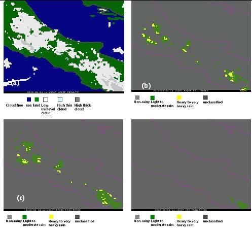
7 Figure 5: 2010 July 06 th at 11:30GMT (a) MACSP results; (b) rain rate radar results collocated in MSG-SEVIRI grid; (c) RACIV rain rate results; (d) MPE rain rate results. Figure 6: 2010 August 04 th at 14:15GMT (a) MACSP results; (b) rain rate radar results collocated in MSG-SEVIRI grid; (c) RACIV rain rate results; (d) MPE rain rate results.
8 CONCLUSIONS This study proposes the statistical algorithm, RAinfall Confidence estimation from Infrared and Visible observations, which uses the MSG-SEVIRI Infrared/Visible measurements to obtain rain rate confidences. The advantage of using MSG-SEVIRI VIS/IR observations comes from high spatial and temporal resolution. These characteristics are very important for both the continuous monitoring of extreme events and the study of events characterized by short duration, high temporal variability, and small size (of the order of the MSG-SEVIRI spatial resolution). RACIV detects rainy clouds and it classifies the rainy pixels as light to moderate or heavy to very heavy rainy. It has been trained on the AMSU-B PEMW rain rates and validated on the basis of the rain rates observation from the Italian DPC operational weather radar network. Currently RACIV works in the Mediterranean area, approximately between 35 and 45 degrees of latitude north, and 10 and 20 degrees of longitude east, but in principle it could operate in any area. The accuracy score shows that large fractions (97%) of the pixels are correctly identified as rainy or non-rainy by RACIV. However, it is recognized that this result is heavily influenced by the high occurrence of non-rainy pixels. The bias score (1.50 for RACIV and 1.29 for MPE) indicates that both RACIV and MPE have a general tendency to overestimate rainy pixels. POD shows that 71% of the rainy area is correctly detected by RACIV, while MPE detect 56% of the rainy area correctly. FAR reports that 52% and 56% of the pixels detected as rainy by RACIV and MPE, respectively, are false alarms. The bias score for light to moderate and heavy to very heavy classes indicates that both RACIV and MPE have a general tendency to overestimate rainy pixels in the two classes, and this tendency is higher for RACIV. POD shows that 87% and 50% of rainy pixels are correctly detected by RACIV and MPE in the light to moderate class, respectively. RACIV and MPE correctly detect 76% and 24% of rainy pixels in the heavy to very heavy class, respectively. FAR is about 80% both for RACIV and MPE in the heavy to very heavy class, while it is 71% and 59% in the light to moderate class for RACIV and MPE, respectively. ACKNOWLEDGEMENTS The authors acknowledge the Italian Department of Civil Protection (DPC) for providing data from the national radar network in the framework of the CETEMPS-DPC IDRA project. The staff of HIMET s.r.l is also acknowledged for greatly facilitating the access to the data archive. The MPE rain rate products have been taken from the Eumetsat Archive. REFERENCES Heineman, T., Lattanzio, A., Roveda, F., The Eumetsat Multi-sensor precipitation estimate, Eumetsat Proceeding Di Tomaso, E., Romano, F., Cuomo, V., 2009:Rainfall estimation from satellite passive microwave observations in the range 89GHz to 190GHz, Journal of Geophysical Research, 114, D18203, doi: /2009jd Ebert, E, 2008: Forecast verification Issues, Methods and FAQ, 5 Dec. (Available at Ricciardelli, E., Romano, F., Cuomo, V., 2008: Physical and statistical approaches for cloud identification using Meteosat Second Generation Spinning Enhanced Visibile and Infrared Imager, Remote Sensing of Environment, 112,
MAIN ATTRIBUTES OF THE PRECIPITATION PRODUCTS DEVELOPED BY THE HYDROLOGY SAF PROJECT RESULTS OF THE VALIDATION IN HUNGARY
 MAIN ATTRIBUTES OF THE PRECIPITATION PRODUCTS DEVELOPED BY THE HYDROLOGY SAF PROJECT RESULTS OF THE VALIDATION IN HUNGARY Eszter Lábó OMSZ-Hungarian Meteorological Service, Budapest, Hungary labo.e@met.hu
Judit Kerényi. OMSZ-Hungarian Meteorological Service P.O.Box 38, H-1525, Budapest Hungary Abstract
 Comparison of the precipitation products of Hydrology SAF with the Convective Rainfall Rate of Nowcasting-SAF and the Multisensor Precipitation Estimate of EUMETSAT Judit Kerényi OMSZ-Hungarian Meteorological
THE EUMETSAT MULTI-SENSOR PRECIPITATION ESTIMATE (MPE)
") THE EUMETSAT MULTI-SENSOR PRECIPITATION ESTIMATE (MPE) Thomas Heinemann, Alessio Lattanzio and Fausto Roveda EUMETSAT Am Kavalleriesand 31, 64295 Darmstadt, Germany ABSTRACT The combination of measurements
THE EUMETSAT MULTI-SENSOR PRECIPITATION ESTIMATE (MPE) Thomas Heinemann, Alessio Lattanzio and Fausto Roveda EUMETSAT Am Kavalleriesand 31, 64295 Darmstadt, Germany ABSTRACT The combination of measurements
H-SAF future developments on Convective Precipitation Retrieval
 H-SAF future developments on Convective Precipitation Retrieval Francesco Zauli 1, Daniele Biron 1, Davide Melfi 1, Antonio Vocino 1, Massimiliano Sist 2, Michele De Rosa 2, Matteo Picchiani 2, De Leonibus
Satellite-Based Detection of Fog and Very Low Stratus
 Satellite-Based Detection of Fog and Very Low Stratus A High-Latitude Case Study Centred on the Helsinki Testbed Experiment J. Cermak 1, J. Kotro 2, O. Hyvärinen 2, V. Nietosvaara 2, J. Bendix 1 1: Laboratory
Description of the case study
 Description of the case study During the night and early morning of the 14 th of July 011 the significant cloud layer expanding in the West of the country and slowly moving East produced precipitation
Judit Kerényi. OMSZ - Hungarian Meteorological Service, Budapest, Hungary. H-1525 Budapest, P.O.Box 38, Hungary.
 SATELLITE-DERIVED PRECIPITATION ESTIMATIONS DEVELOPED BY THE HYDROLOGY SAF PROJECT CASE STUDIES FOR THE INVESTIGATION OF THEIR ACCURACY AND FEATURES IN HUNGARY Judit Kerényi OMSZ - Hungarian Meteorological
Validation Report for Precipitation products from Cloud Physical Properties (PPh-PGE14: PCPh v1.0 & CRPh v1.0)
") Page: 1/26 Validation Report for Precipitation SAF/NWC/CDOP2/INM/SCI/VR/15, Issue 1, Rev. 0 15 July 2013 Applicable to SAFNWC/MSG version 2013 Prepared by AEMET Page: 2/26 REPORT SIGNATURE TABLE Function
Page: 1/26 Validation Report for Precipitation SAF/NWC/CDOP2/INM/SCI/VR/15, Issue 1, Rev. 0 15 July 2013 Applicable to SAFNWC/MSG version 2013 Prepared by AEMET Page: 2/26 REPORT SIGNATURE TABLE Function
RAIN-RATE ESTIMATION FROM SEVIRI/MSG AND AMSR-E/AQUA. VALIDATION AND COMPARISON BY USING U.K. WEATHER RADARS
 RAIN-RATE ESTIMATION FROM SEVIRI/MSG AND AMSR-E/AQUA. VALIDATION AND COMPARISON BY USING U.K. WEATHER RADARS Capacci Davide 1, Federico Porcù 1 and Franco Prodi 1,2 1. University of Ferrara, Department
Rain rate retrieval using the 183-WSL algorithm
 Rain rate retrieval using the 183-WSL algorithm S. Laviola, and V. Levizzani Institute of Atmospheric Sciences and Climate, National Research Council Bologna, Italy (s.laviola@isac.cnr.it) ABSTRACT High
Status of the GeoKompsat-2A AMI rainfall rate algorithm
 Status of the GeoKompsat-2A AMI rainfall rate algorithm Dong-Bin Shin, Damwon So, Hyo-Jin Park Department of Atmospheric Sciences, Yonsei University Algorithm Strategy Well-known assumption in IR-based
VALIDATION RESULTS OF THE OPERATIONAL LSA-SAF SNOW COVER MAPPING
 VALIDATION RESULTS OF THE OPERATIONAL LSA-SAF SNOW COVER MAPPING Niilo Siljamo, Otto Hyvärinen Finnish Meteorological Institute, Erik Palménin aukio 1, P.O.Box 503, FI-00101 HELSINKI Abstract Hydrological
Two Prototype Hail Detection Algorithms Using the Advanced Microwave Sounding Unit (AMSU)
") Two Prototype Hail Detection Algorithms Using the Advanced Microwave Sounding Unit (AMSU) 2 James Beauchamp (vajim@essic.umd.edu) 2 1 Ralph Ferraro, 3 Sante Laviola 1 Satellite Climate Studies Branch,
Two Prototype Hail Detection Algorithms Using the Advanced Microwave Sounding Unit (AMSU) 2 James Beauchamp (vajim@essic.umd.edu) 2 1 Ralph Ferraro, 3 Sante Laviola 1 Satellite Climate Studies Branch,
SNOW COVER MAPPING USING METOP/AVHRR AND MSG/SEVIRI
 SNOW COVER MAPPING USING METOP/AVHRR AND MSG/SEVIRI Niilo Siljamo, Markku Suomalainen, Otto Hyvärinen Finnish Meteorological Institute, P.O.Box 503, FI-00101 Helsinki, Finland Abstract Weather and meteorological
NEW SCHEME TO IMPROVE THE DETECTION OF RAINY CLOUDS IN PUERTO RICO
 NEW SCHEME TO IMPROVE THE DETECTION OF RAINY CLOUDS IN PUERTO RICO Joan Manuel Castro Sánchez Advisor Dr. Nazario Ramirez UPRM NOAA CREST PRYSIG 2016 October 7, 2016 Introduction A cloud rainfall event
Precipitation process and rainfall intensity differentiation using Meteosat Second Generation Spinning Enhanced Visible and Infrared Imager data
 JOURNAL OF GEOPHYSICAL RESEARCH, VOL. 113,, doi:10.1029/2008jd010464, 2008 Precipitation process and rainfall intensity differentiation using Meteosat Second Generation Spinning Enhanced Visible and Infrared
WMO Aeronautical Meteorology Scientific Conference 2017
 Session 1 Science underpinning meteorological observations, forecasts, advisories and warnings 1.6 Observation, nowcast and forecast of future needs 1.6.1 Advances in observing methods and use of observations
SAFNWC/MSG SEVIRI CLOUD PRODUCTS
 SAFNWC/MSG SEVIRI CLOUD PRODUCTS M. Derrien and H. Le Gléau Météo-France / DP / Centre de Météorologie Spatiale BP 147 22302 Lannion. France ABSTRACT Within the SAF in support to Nowcasting and Very Short
EUMETSAT Hydrological SAF H05 product development at CNMCA
 EUMETSAT Conference 2013 Session 3 - Quantitative applications for nowcasting Poster Presentation EUMETSAT Hydrological SAF H05 product development at CNMCA Antonio Vocino, Valentina Scappiti, Daniele
Severe storms over the Mediterranean Sea: A satellite and model analysis
 National Research Council of Italy Severe storms over the Mediterranean Sea: A satellite and model analysis V. Levizzani, S. Laviola, A. Malvaldi, M. M. Miglietta, and E. Cattani 6 th International Precipitation
PRECONVECTIVE SOUNDING ANALYSIS USING IASI AND MSG- SEVIRI
 PRECONVECTIVE SOUNDING ANALYSIS USING IASI AND MSG- SEVIRI Marianne König, Dieter Klaes EUMETSAT, Eumetsat-Allee 1, 64295 Darmstadt, Germany Abstract EUMETSAT operationally generates the Global Instability
A HIGH RESOLUTION EUROPEAN CLOUD CLIMATOLOGY FROM 15 YEARS OF NOAA/AVHRR DATA
 A HIGH RESOLUTION EUROPEAN CLOUD CLIMATOLOGY FROM 15 YEARS OF NOAA/AVHRR DATA R. Meerkötter 1, G. Gesell 2, V. Grewe 1, C. König 1, S. Lohmann 1, H. Mannstein 1 Deutsches Zentrum für Luft- und Raumfahrt
Assessment of Precipitation Characters between Ocean and Coast area during Winter Monsoon in Taiwan
 Assessment of Precipitation Characters between Ocean and Coast area during Winter Monsoon in Taiwan Peter K.H. Wang Central Weather Bureau Abstract SSM/I has been applied in derivation of liquid water
"Experiences with use of EUMETSAT MPEF GII product for convection/storm nowcasting"
 "Experiences with use of EUMETSAT MPEF GII product for convection/storm nowcasting" Marianne König 1, Monika Pajek 2, Piotr Struzik 2 1) EUMETSAT 2) Institute of Meteorology and Water Management, Kraków,
Lecture 19: Operational Remote Sensing in Visible, IR, and Microwave Channels
 MET 4994 Remote Sensing: Radar and Satellite Meteorology MET 5994 Remote Sensing in Meteorology Lecture 19: Operational Remote Sensing in Visible, IR, and Microwave Channels Before you use data from any
USE OF SATELLITE INFORMATION IN THE HUNGARIAN NOWCASTING SYSTEM
 USE OF SATELLITE INFORMATION IN THE HUNGARIAN NOWCASTING SYSTEM Mária Putsay, Zsófia Kocsis and Ildikó Szenyán Hungarian Meteorological Service, Kitaibel Pál u. 1, H-1024, Budapest, Hungary Abstract The
NWP SAF. Quantitative precipitation estimation from satellite data. Satellite Application Facility for Numerical Weather Prediction
 NWP SAF Satellite Application Facility for Numerical Weather Prediction Document NWPSAF-MO-VS-011 Version 1.0 15 April 2006 Quantitative precipitation estimation from satellite data Sante Laviola University
D. Cimini*, V. Cuomo*, S. Laviola*, T. Maestri, P. Mazzetti*, S. Nativi*, J. M. Palmer*, R. Rizzi and F. Romano*
 D. Cimini*, V. Cuomo*, S. Laviola*, T. Maestri, P. Mazzetti*, S. Nativi*, J. M. Palmer*, R. Rizzi and F. Romano* * Istituto di Metodologie per l Analisi Ambientale, IMAA/CNR, Potenza, Italy ADGB - Dip.
Rainfall estimation from satellite passive microwave observations in the range 89 GHz to 190 GHz
 JOURNAL OF GEOPHYSICAL RESEARCH, VOL. 114,, doi:10.1029/2009jd011746, 2009 Rainfall estimation from satellite passive microwave observations in the range 89 GHz to 190 GHz E. Di Tomaso, 1 F. Romano, 1
Improving real time observation and nowcasting RDT. E de Coning, M Gijben, B Maseko and L van Hemert Nowcasting and Very Short Range Forecasting
 Improving real time observation and nowcasting RDT E de Coning, M Gijben, B Maseko and L van Hemert Nowcasting and Very Short Range Forecasting Introduction Satellite Application Facilities (SAFs) are
Retrieval of precipitation from Meteosat-SEVIRI geostationary satellite observations
 Retrieval of precipitation from Meteosat-SEVIRI geostationary satellite observations Jan Fokke Meirink, Hidde Leijnse (KNMI) Rob Roebeling (EUMETSAT) Overview Introduction Algorithm description Validation
Comparison of cloud statistics from Meteosat with regional climate model data
 Comparison of cloud statistics from Meteosat with regional climate model data R. Huckle, F. Olesen, G. Schädler Institut für Meteorologie und Klimaforschung, Forschungszentrum Karlsruhe, Germany (roger.huckle@imk.fzk.de
The retrieval of the atmospheric humidity parameters from NOAA/AMSU data for winter season.
 The retrieval of the atmospheric humidity parameters from NOAA/AMSU data for winter season. Izabela Dyras, Bożena Łapeta, Danuta Serafin-Rek Satellite Research Department, Institute of Meteorology and
Climatologies of ultra-low clouds over the southern West African monsoon region
 Climatologies of ultra-low clouds over the southern West African monsoon region Andreas H. Fink 1, R. Schuster 1, R. van der Linden 1, J. M. Schrage 2, C. K. Akpanya 2, and C. Yorke 3 1 Institute of Geophysics
Remote Sensing of Precipitation
 Lecture Notes Prepared by Prof. J. Francis Spring 2003 Remote Sensing of Precipitation Primary reference: Chapter 9 of KVH I. Motivation -- why do we need to measure precipitation with remote sensing instruments?
H SAF SATELLITE APPLICATION FACILITY ON SUPPORT TO OPERATIONAL HYDROLOGY AND WATER MANAGEMENT EUMETSAT NETWORK OF SATELLITE APPLICATION FACILITIES
 H SAF SATELLITE APPLICATION FACILITY ON SUPPORT TO OPERATIONAL HYDROLOGY AND WATER MANAGEMENT EUMETSAT NETWORK OF SATELLITE APPLICATION FACILITIES H-SAF: SATELLITE PRODUCTS FOR OPERATIONAL HYDROLOGY H-SAF
MSGVIEW: AN OPERATIONAL AND TRAINING TOOL TO PROCESS, ANALYZE AND VISUALIZATION OF MSG SEVIRI DATA
 MSGVIEW: AN OPERATIONAL AND TRAINING TOOL TO PROCESS, ANALYZE AND VISUALIZATION OF MSG SEVIRI DATA Aydın Gürol Ertürk Turkish State Meteorological Service, Remote Sensing Division, CC 401, Kalaba Ankara,
Remote Sensing in Meteorology: Satellites and Radar. AT 351 Lab 10 April 2, Remote Sensing
 Remote Sensing in Meteorology: Satellites and Radar AT 351 Lab 10 April 2, 2008 Remote Sensing Remote sensing is gathering information about something without being in physical contact with it typically
Extending the use of surface-sensitive microwave channels in the ECMWF system
 Extending the use of surface-sensitive microwave channels in the ECMWF system Enza Di Tomaso and Niels Bormann European Centre for Medium-range Weather Forecasts Shinfield Park, Reading, RG2 9AX, United
MSG system over view
 MSG system over view 1 Introduction METEOSAT SECOND GENERATION Overview 2 MSG Missions and Services 3 The SEVIRI Instrument 4 The MSG Ground Segment 5 SAF Network 6 Conclusions METEOSAT SECOND GENERATION
PRECIPITATION ESTIMATION FROM INFRARED SATELLITE IMAGERY
 PRECIPITATION ESTIMATION FROM INFRARED SATELLITE IMAGERY A.M. BRASJEN AUGUST 2014 1 2 PRECIPITATION ESTIMATION FROM INFRARED SATELLITE IMAGERY MASTER S THESIS AUGUST 2014 A.M. BRASJEN Department of Geoscience
FUNDAMENTALS OF REMOTE SENSING FOR RISKS ASSESSMENT. 1. Introduction
 FUNDAMENTALS OF REMOTE SENSING FOR RISKS ASSESSMENT FRANÇOIS BECKER International Space University and University Louis Pasteur, Strasbourg, France; E-mail: becker@isu.isunet.edu Abstract. Remote sensing
A Time Lag Model to Estimate Rainfall Rate Based on GOES Data
 A Time Lag Model to Estimate Rainfall Rate Based on GOES Data Nazario D. Ramirez, Robert J. Kuligowski, and Joan M. Castro Octava Reunión Nacional de Percepción Remota y Sistemas Geográficos de Información
Assimilation of precipitation-related observations into global NWP models
 Assimilation of precipitation-related observations into global NWP models Alan Geer, Katrin Lonitz, Philippe Lopez, Fabrizio Baordo, Niels Bormann, Peter Lean, Stephen English Slide 1 H-SAF workshop 4
Remote Sensing Seminar 8 June 2007 Benevento, Italy. Lab 5 SEVIRI and MODIS Clouds and Fires
 Remote Sensing Seminar 8 June 2007 Benevento, Italy Lab 5 SEVIRI and MODIS Clouds and Fires Table: SEVIRI Channel Number, Wavelength (µm), and Primary Application Reflective Bands 1,2 0.635, 0.81 land/cld
Current verification practices with a particular focus on dust
 Current verification practices with a particular focus on dust Marion Mittermaier and Ric Crocker Outline 1. Guide to developing verification studies 2. Observations at the root of it all 3. Grid-to-point,
MESO-NH cloud forecast verification with satellite observation
 MESO-NH cloud forecast verification with satellite observation Jean-Pierre CHABOUREAU Laboratoire d Aérologie, University of Toulouse and CNRS, France http://mesonh.aero.obs-mip.fr/chaboureau/ DTC Verification
CHARACTERISATION OF STORM SEVERITY BY USE OF SELECTED CONVECTIVE CELL PARAMETERS DERIVED FROM SATELLITE DATA
 CHARACTERISATION OF STORM SEVERITY BY USE OF SELECTED CONVECTIVE CELL PARAMETERS DERIVED FROM SATELLITE DATA Piotr Struzik Institute of Meteorology and Water Management, Satellite Remote Sensing Centre
Assimilation of MSG visible and near-infrared reflectivity in KENDA/COSMO
 Assimilation of MSG visible and near-infrared reflectivity in KENDA/COSMO Leonhard Scheck1,2, Tobias Necker1,2, Pascal Frerebeau2, Bernhard Mayer2, Martin Weissmann1,2 1) Hans-Ertl-Center for Weather Research,
Cloud analysis from METEOSAT data using image segmentation for climate model verification
 Cloud analysis from METEOSAT data using image segmentation for climate model verification R. Huckle 1, F. Olesen 2 Institut für Meteorologie und Klimaforschung, 1 University of Karlsruhe, 2 Forschungszentrum
SNOW COVER MAPPING USING METOP/AVHRR DATA
 SNOW COVER MAPPING USING METOP/AVHRR DATA Niilo Siljamo, Markku Suomalainen, Otto Hyvärinen Finnish Meteorological Institute, Erik Palménin Aukio 1, FI-00101 Helsinki, Finland Abstract LSA SAF snow cover
LANDSAF SNOW COVER MAPPING USING MSG/SEVIRI DATA
 LANDSAF SNOW COVER MAPPING USING MSG/SEVIRI DATA Niilo Siljamo and Otto Hyvärinen Finnish Meteorological Institute, Erik Palménin aukio 1, P.O.Box 503, FI-00101 Helsinki, Finland Abstract Land Surface
22B.5 LONG-TERM ASSESSMENT OF THE DPR RAINFALL PRODUCTS IN THE MEDITERRANEAN AREA ACCORDING TO THE H-SAF VALIDATION PROTOCOL
 22B.5 LONG-TERM ASSESSMENT OF THE RAINFALL PRODUCTS IN THE MEDITERRANEAN AREA ACCORDING TO THE H-SAF VALIDATION PROTOCOL Marco Petracca *, Silvia Puca, Stefano Sebastianelli, Gianfranco Vulpiani Department
THE IMPACT OF NEFODINA CONVECTIVE CLOUDS IDENTIFICATION IN THE RAIN RATE RETRIEVAL OF H-SAF
 THE IMPACT OF NEFODINA CONVECTIVE CLOUDS IDENTIFICATION IN THE RAIN RATE RETRIEVAL OF H-SAF Davide Melfi, Francesco Zauli, Daniele Biron, Antonio Vocino, Massimiliano Sist C.N.M.C.A. Centro Nazionale di
Towards a better use of AMSU over land at ECMWF
 Towards a better use of AMSU over land at ECMWF Blazej Krzeminski 1), Niels Bormann 1), Fatima Karbou 2) and Peter Bauer 1) 1) European Centre for Medium-range Weather Forecasts (ECMWF), Shinfield Park,
Bias correction of satellite data at Météo-France
 Bias correction of satellite data at Météo-France É. Gérard, F. Rabier, D. Lacroix, P. Moll, T. Montmerle, P. Poli CNRM/GMAP 42 Avenue Coriolis, 31057 Toulouse, France 1. Introduction Bias correction at
THE ATMOSPHERIC MOTION VECTOR RETRIEVAL SCHEME FOR METEOSAT SECOND GENERATION. Kenneth Holmlund. EUMETSAT Am Kavalleriesand Darmstadt Germany
 THE ATMOSPHERIC MOTION VECTOR RETRIEVAL SCHEME FOR METEOSAT SECOND GENERATION Kenneth Holmlund EUMETSAT Am Kavalleriesand 31 64293 Darmstadt Germany ABSTRACT The advent of the Meteosat Second Generation
Retrieving Snowfall Rate with Satellite Passive Microwave Measurements
 Retrieving Snowfall Rate with Satellite Passive Microwave Measurements Huan Meng 1, Ralph Ferraro 1, Banghua Yan 1, Cezar Kongoli 2, Nai-Yu Wang 2, Jun Dong 2, Limin Zhao 1 1 NOAA/NESDIS, USA 2 Earth System
URSI-F Microwave Signatures Meeting 2010, Florence, Italy, October 4 8, Thomas Meissner Lucrezia Ricciardulli Frank Wentz
 URSI-F Microwave Signatures Meeting 2010, Florence, Italy, October 4 8, 2010 Wind Measurements from Active and Passive Microwave Sensors High Winds and Winds in Rain Thomas Meissner Lucrezia Ricciardulli
Satellite Radiance Data Assimilation at the Met Office
 Satellite Radiance Data Assimilation at the Met Office Ed Pavelin, Stephen English, Brett Candy, Fiona Hilton Outline Summary of satellite data used in the Met Office NWP system Processing and quality
LIST OF TABLES Table 1. Table 2. Table 3. Table 4.
 LIST OF TABLES Table. Dataset names, their versions, and variables used in this study. The algorithm names (GPROF, GPROF7, and GSMaP) are added in the parenthesis after each TMI rainfall dataset. This
THE LAND-SAF SURFACE ALBEDO AND DOWNWELLING SHORTWAVE RADIATION FLUX PRODUCTS
 THE LAND-SAF SURFACE ALBEDO AND DOWNWELLING SHORTWAVE RADIATION FLUX PRODUCTS Bernhard Geiger, Dulce Lajas, Laurent Franchistéguy, Dominique Carrer, Jean-Louis Roujean, Siham Lanjeri, and Catherine Meurey
TROPICAL-LIKE MEDITERRANEAN STORMS: AN ANALYSIS FROM SATELLITE
 TROPICAL-LIKE MEDITERRANEAN STORMS: AN ANALYSIS FROM SATELLITE Angel Luque, Lluis Fita, Romualdo Romero, Sergio Alonso Meteorology Group, Balearic Islands University, Spain Abstract Tropical-like storms
HOMOGENEOUS VALIDATION SCHEME OF THE OSI SAF SEA SURFACE TEMPERATURE PRODUCTS
 HOMOGENEOUS VALIDATION SCHEME OF THE OSI SAF SEA SURFACE TEMPERATURE PRODUCTS Pierre Le Borgne, Gérard Legendre, Anne Marsouin, Sonia Péré Météo-France/DP/Centre de Météorologie Spatiale BP 50747, 22307
Satellite-based thunderstorm tracking, monitoring and nowcasting over South Africa
 Satellite-based thunderstorm tracking, monitoring and nowcasting over South Africa Caroline Forster 1, Estelle de Coning 2, Sebastian Diebel 1, Tobias Zinner 3 EUMETSAT Meteorological Satellite Conference
P4.4 THE COMBINATION OF A PASSIVE MICROWAVE BASED SATELLITE RAINFALL ESTIMATION ALGORITHM WITH AN IR BASED ALGORITHM
 P4.4 THE COMBINATION OF A PASSIVE MICROWAVE BASED SATELLITE RAINFALL ESTIMATION ALGORITHM WITH AN IR BASED ALGORITHM Robert Joyce 1), John E. Janowiak 2), and Phillip A. Arkin 3, Pingping Xie 2) 1) RS
Satellite data assimilation for Numerical Weather Prediction II
 Satellite data assimilation for Numerical Weather Prediction II Niels Bormann European Centre for Medium-range Weather Forecasts (ECMWF) (with contributions from Tony McNally, Jean-Noël Thépaut, Slide
Stability in SeaWinds Quality Control
 Ocean and Sea Ice SAF Technical Note Stability in SeaWinds Quality Control Anton Verhoef, Marcos Portabella and Ad Stoffelen Version 1.0 April 2008 DOCUMENTATION CHANGE RECORD Reference: Issue / Revision:
Recent improvements in the all-sky assimilation of microwave radiances at the ECMWF
 Recent improvements in the all-sky assimilation of microwave radiances at the ECMWF Katrin Lonitz, Alan Geer and many more katrin.lonitz@ecmwf.int ECMWF January 30, 2018 clear sky assimilation all-sky
Rainfall estimation over the Taiwan Island from TRMM/TMI data
 P1.19 Rainfall estimation over the Taiwan Island from TRMM/TMI data Wann-Jin Chen 1, Ming-Da Tsai 1, Gin-Rong Liu 2, Jen-Chi Hu 1 and Mau-Hsing Chang 1 1 Dept. of Applied Physics, Chung Cheng Institute
Application of automated CB/TCU detection based on radar and satellite data
 Application of automated CB/TCU detection based on radar and satellite data Paul de Valk, and Rudolf van Westhrenen Royal Netherlands Meteorological Institute, Ministry of Infrastruture and Environment
SATELLITE MONITORING OF THE CONVECTIVE STORMS
 SATELLITE MONITORING OF THE CONVECTIVE STORMS FORECASTERS POINT OF VIEW Michaela Valachová, EUMETSAT Workshop at ECMWF User Meeting Reading, 13 June 2017 Central Forecasting Office, Prague michaela.valachova@chmi.cz
Scientific and Validation Report for the Extrapolated Imagery Processor of the NWC/GEO
 Page: 1/95 the Extrapolated Imagery Processor of the NWC/GEO NWC/CDOP2/GEO/ZAMG/SCI/VR/EXIM, Issue 1.0 22 May 2017 Applicable to GEO-EXIM-v1.0 (NWC-043) Prepared by ZAMG Page: 2/95 REPORT SIGNATURE TABLE
Nowcasting of Severe Weather from Satellite Images (for Southern
 Nowcasting of Severe Weather from Satellite Images (for Southern Europe) Petra Mikuš Jurković Forecasting/ nowcasting of convective storms NWP models cannot well predict the exact location and intesity
OSI SAF SST Products and Services
 OSI SAF SST Products and Services Pierre Le Borgne Météo-France/DP/CMS (With G. Legendre, A. Marsouin, S. Péré, S. Philippe, H. Roquet) 2 Outline Satellite IR radiometric measurements From Brightness Temperatures
A Projection Algorithm for Satellite Rainfall Detection
 A Projection Algorithm for Satellite Rainfall Detection NAZARIO D. RAMIREZ-BELTRAN 1, ROBERT J. KULIGOWSKI 2, JOAN M. CASTRO 3, MELVIN J. CARDONA 3 and RAMON VASQUEZ 3. 1 Department of Industrial Engineering,
INTERPRETATION OF MSG IMAGES, PRODUCTS AND SAFNWC OUTPUTS FOR DUTY FORECASTERS
 INTERPRETATION OF MSG IMAGES, PRODUCTS AND SAFNWC OUTPUTS FOR DUTY FORECASTERS M. Putsay, M. Rajnai, M. Diószeghy, J. Kerényi, I.G. Szenyán and S. Kertész Hungarian Meteorological Service, H-1525 Budapest,
Results from the ARM Mobile Facility
 AMMA Workshop, Toulouse, November 2006 Results from the ARM Mobile Facility Background Anthony Slingo Environmental Systems Science Centre University of Reading, UK Selected results, including a major
Rosemary Munro*, Graeme Kelly, Michael Rohn* and Roger Saunders
 ASSIMILATION OF METEOSAT RADIANCE DATA WITHIN THE 4DVAR SYSTEM AT ECMWF Rosemary Munro*, Graeme Kelly, Michael Rohn* and Roger Saunders European Centre for Medium Range Weather Forecasts Shinfield Park,
ASSIMILATION OF CLOUDY AMSU-A MICROWAVE RADIANCES IN 4D-VAR 1. Stephen English, Una O Keeffe and Martin Sharpe
 ASSIMILATION OF CLOUDY AMSU-A MICROWAVE RADIANCES IN 4D-VAR 1 Stephen English, Una O Keeffe and Martin Sharpe Met Office, FitzRoy Road, Exeter, EX1 3PB Abstract The assimilation of cloud-affected satellite
Model errors in tropical cloud and precipitation revealed by the assimilation of MW imagery
 Model errors in tropical cloud and precipitation revealed by the assimilation of MW imagery Katrin Lonitz, Alan Geer, Philippe Lopez + many other colleagues 20 November 2014 Katrin Lonitz ( ) Tropical
Meteorological Satellite Image Interpretations, Part III. Acknowledgement: Dr. S. Kidder at Colorado State Univ.
 Meteorological Satellite Image Interpretations, Part III Acknowledgement: Dr. S. Kidder at Colorado State Univ. Dates EAS417 Topics Jan 30 Introduction & Matlab tutorial Feb 1 Satellite orbits & navigation
A Microwave Snow Emissivity Model
 A Microwave Snow Emissivity Model Fuzhong Weng Joint Center for Satellite Data Assimilation NOAA/NESDIS/Office of Research and Applications, Camp Springs, Maryland and Banghua Yan Decision Systems Technologies
Hail nowcast exploiting radar and satellite observations
 Federal Department of Home Affairs FDHA Federal Office of Meteorology and Climatology MeteoSwiss Hail nowcast exploiting radar and satellite observations Ulrich Hamann, Elena Leonarduzzi, Kristopher Bedka,
The assimilation of AMSU and SSM/I brightness temperatures in clear skies at the Meteorological Service of Canada
 The assimilation of AMSU and SSM/I brightness temperatures in clear skies at the Meteorological Service of Canada Abstract David Anselmo and Godelieve Deblonde Meteorological Service of Canada, Dorval,
Nowcasting thunderstorms for aeronautical end-users
 Nowcasting thunderstorms for aeronautical end-users Jean-Marc Moisselin Météo-France, Nowcasting Department co-authors: Céline Jauffret (Météo-France) Overview Introduction SAT RADAR NWP image crédit:
Meteosat Third Generation (MTG): Lightning Imager and its products Jochen Grandell
: Lightning Imager and its products Jochen Grandell") 1 Go to View menu and click on Slide Master to update this footer. Include DM reference, version number and date Meteosat Third Generation (MTG): Lightning Imager and its products Jochen Grandell Topics
1 Go to View menu and click on Slide Master to update this footer. Include DM reference, version number and date Meteosat Third Generation (MTG): Lightning Imager and its products Jochen Grandell Topics
Remote Sensing of Precipitation on the Tibetan Plateau Using the TRMM Microwave Imager
 AUGUST 2001 YAO ET AL. 1381 Remote Sensing of Precipitation on the Tibetan Plateau Using the TRMM Microwave Imager ZHANYU YAO Laboratory for Severe Storm Research, Department of Geophysics, Peking University,
On the Satellite Determination of Multilayered Multiphase Cloud Properties. Science Systems and Applications, Inc., Hampton, Virginia 2
 JP1.10 On the Satellite Determination of Multilayered Multiphase Cloud Properties Fu-Lung Chang 1 *, Patrick Minnis 2, Sunny Sun-Mack 1, Louis Nguyen 1, Yan Chen 2 1 Science Systems and Applications, Inc.,
VALIDATION OF INSAT-3D DERIVED RAINFALL. (Submitted by Suman Goyal, IMD) Summary and Purpose of Document
 Summary and Purpose of Document") WORLD METEOROLOGICAL ORGANIZATION COMMISSION FOR BASIC SYSTEMS OPEN PROGRAMME AREA GROUP ON INTEGRATED OBSERVING SYSTEMS INTER-PROGRAMME EXPERT TEAM ON SATELLITE UTILIZATION AND PRODUCTS SECOND SESSION
WORLD METEOROLOGICAL ORGANIZATION COMMISSION FOR BASIC SYSTEMS OPEN PROGRAMME AREA GROUP ON INTEGRATED OBSERVING SYSTEMS INTER-PROGRAMME EXPERT TEAM ON SATELLITE UTILIZATION AND PRODUCTS SECOND SESSION
Observations needed for verification of additional forecast products
 Observations needed for verification of additional forecast products Clive Wilson ( & Marion Mittermaier) 12th Workshop on Meteorological Operational Systems, ECMWF, 2-6 November 2009 Additional forecast
All-sky assimilation of MHS and HIRS sounder radiances
 All-sky assimilation of MHS and HIRS sounder radiances Alan Geer 1, Fabrizio Baordo 2, Niels Bormann 1, Stephen English 1 1 ECMWF 2 Now at Bureau of Meteorology, Australia All-sky assimilation at ECMWF
Satellite-based Convection Nowcasting and Aviation Turbulence Applications
 Satellite-based Convection Nowcasting and Aviation Turbulence Applications Kristopher Bedka Cooperative Institute for Meteorological Satellite Studies (CIMSS), University of Wisconsin-Madison In collaboration
Refinement and operational implementation of a rain rate algorithm based AMSU/MHS, and SEVIRI data within the Hydrological-SAF
 Refinement and operational implementation of a rain rate algorithm based AMSU/MHS, and SEVIRI data within the Hydrological-SAF 1 Puca S., 2 Antonelli P., 2 Bennartz R., 1 Corina A., 3 De Leonibus L., 1
Carmine Serio, Guido Masiello. DIFA, University of Basilicata, Italy
 Carmine Serio, Guido Masiello DIFA, University of Basilicata, Italy Stephen Tjemkes, Poster in this conference hs-test Surface temperature test IASI stand-alone cloud detection scheme The baseline Test
Direct assimilation of all-sky microwave radiances at ECMWF
 Direct assimilation of all-sky microwave radiances at ECMWF Peter Bauer, Alan Geer, Philippe Lopez, Deborah Salmond European Centre for Medium-Range Weather Forecasts Reading, Berkshire, UK Slide 1 17
Cloud detection using SEVIRI IR channels
 Cloud detection using SEVIRI IR channels Alessandro.Ipe@oma.be & Luis Gonzalez Sotelino Royal Meteorological Institute of Belgium GERB Science Team Meeting @ London September 9 10 2009 1 / 19 Overview
Data assimilation of IASI radiances over land.
 Data assimilation of IASI radiances over land. PhD supervised by Nadia Fourrié, Florence Rabier and Vincent Guidard. 18th International TOVS Study Conference 21-27 March 2012, Toulouse Contents 1. IASI
Supplementary Figure 1. Summer mesoscale convective systems rainfall climatology and trends. Mesoscale convective system (MCS) (a) mean total
 (a) mean total") Supplementary Figure 1. Summer mesoscale convective systems rainfall climatology and trends. Mesoscale convective system (MCS) (a) mean total rainfall and (b) total rainfall trend from 1979-2014. Total
Supplementary Figure 1. Summer mesoscale convective systems rainfall climatology and trends. Mesoscale convective system (MCS) (a) mean total rainfall and (b) total rainfall trend from 1979-2014. Total
APPENDIX 2 OVERVIEW OF THE GLOBAL PRECIPITATION MEASUREMENT (GPM) AND THE TROPICAL RAINFALL MEASURING MISSION (TRMM) 2-1
 AND THE TROPICAL RAINFALL MEASURING MISSION (TRMM) 2-1") APPENDIX 2 OVERVIEW OF THE GLOBAL PRECIPITATION MEASUREMENT (GPM) AND THE TROPICAL RAINFALL MEASURING MISSION (TRMM) 2-1 1. Introduction Precipitation is one of most important environmental parameters.
APPENDIX 2 OVERVIEW OF THE GLOBAL PRECIPITATION MEASUREMENT (GPM) AND THE TROPICAL RAINFALL MEASURING MISSION (TRMM) 2-1 1. Introduction Precipitation is one of most important environmental parameters.