A Time Lag Model to Estimate Rainfall Rate Based on GOES Data
|
|
|
- James Stokes
- 5 years ago
- Views:
Transcription


1 A Time Lag Model to Estimate Rainfall Rate Based on GOES Data Nazario D. Ramirez, Robert J. Kuligowski, and Joan M. Castro Octava Reunión Nacional de Percepción Remota y Sistemas Geográficos de Información (PRYSIG). Mayaguez, PR, Nov
2 Outline Motivation Description of data Projection algorithm Relation between radar and satellite variables Lag time model Results Conclusions 2
 Microwave Humidity Sounder (MHS) Observations every 12 hours Geostationary")
3 NEXRAD Motivation Operates in S-band with 10 cm wavelength. Observations at every 6 minutes. The maximum horizontal range is 462 km, Polar satellite Altitude: 870 km Advanced Microwave Sounding Unit-A (AMSU-A) Microwave Humidity Sounder (MHS) Observations every 12 hours Geostationary satellite 35,800 km GOES W longitude and the equator Visible and infrared channels Observations every 15 min 3
4 Motivation The challenge of this work is to infer the presence of rainfall pixels and estimate the rainfall rate by looking the visible reflectance and the brightness temperatures from GOES channels. Infrared channels provide indirect measurements of rainfall. It is known that the presence of heavy rainfall is associated with cold clouds. However, there are cold clouds with no rain, and also there are heavy rains from warm clouds. 4
5 Radar Data NEXRAD data over Puerto Rico come from a WSR- 88D unit located in Cayey (18.12 N, W, m elevation). The radar frequency is 2.7 GHz and the maximum horizontal range is 462 km, and the radar scans the entire island every 6 minutes. The study area covers 121x121 radar pixels with a grid size of 2.6x2.8km. Reflectivity is used to identify rain/no rain pixel Reflectivity is also used for calibrating rainfall rate 5
6 Satellite data for rainfall detection Four bands of the GOES imager are used: Channel 1: visible (0.65 µm), Channel 2: near infrared (3.9 µm), Channel 3: water vapor (6.7 µm), and Channel 4: thermal IR (10.7 µm). Albedo of Channel 2 Two band differences were also calculated: Difference for Ch 2 Ch 4 Difference for Ch 3 Ch 4. 6

7 Satellite data for rainfall estimation The evolution of the cloud microphysical process start by drop condensation, continues with drop grow, and finished with drop precipitation. 7

8 Albedo (3.9μm) Albedo is defined by: Albedo from October 27, 2008 (18:35 UTC) where: α is the albedo at 3.9 microns R 3.9 is the observed radiance from band 2 R e3.9 is the equivalent black body emitted thermal radiation at 3.9 microns for cloud at temperature T S is the solar irradiance of GOES 12 effective radius (microns) scattering angle = solar zenith angle = albedo (%) 8
9 Projection algorithm Based on the angle formed by two vectors in the n-dimensional space. Projection principle: when two vectors are collinear the radiative variables of clouds may exhibit similar properties, and when the vectors are orthogonal the radiative variables may have no elements in common. Radar data are used to identify rain/no rain pixels. The central tendency of each population is used to generate rain and no rain calibration vectors. A pixel from an independent data set is used to create a third vector and classify the third vector into a rain or no rain population. 9


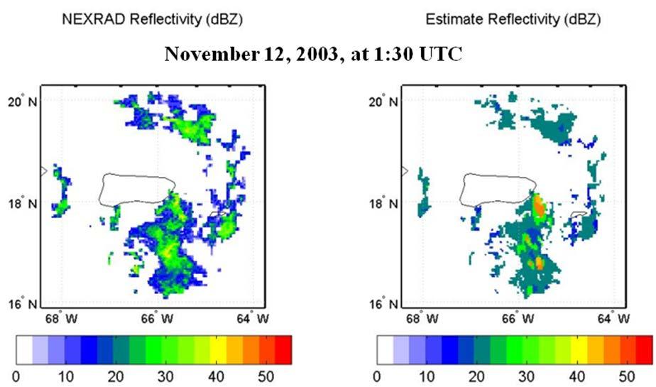
10 The first observation on radar and satellite data (Visible Reflectance) 10
 55 50 45 scattering angle = 100.")
 40 35 30 25 20 15 10")
11 The second observation on radar and satellite data (Albedo) scattering angle = solar zenith angle = effective radius (microns) albedo (%) 11


12 The third observation on radar and satellite data 12
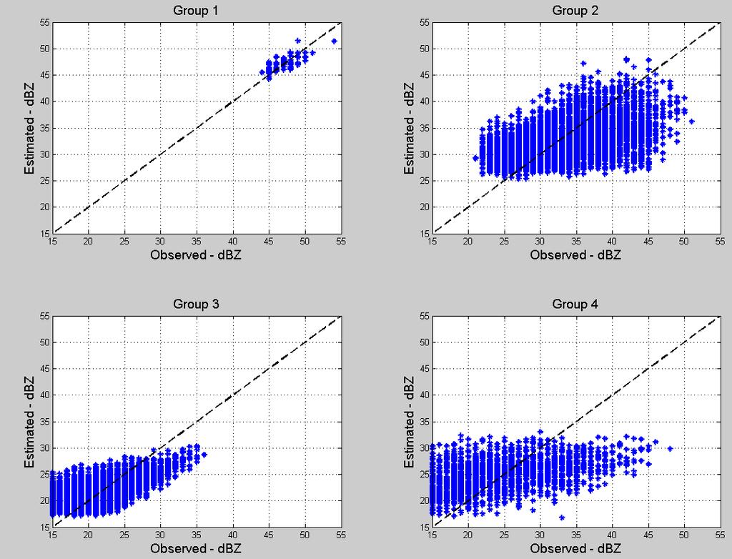
13 Four groups of data BT4 (K) class number 13
14 Time Lag Model The sequence of consecutive images of cloud radiative variables will provide the opportunity of deriving proxy variables for estimating both the evolution of the cloud microphysics and the wind components with visible and IR GOES channels. The rain rate can be estimated by measuring the evolution of the cloud microphysical processes and by using a sequence of images. It is assumed that variations of the cloud radiative properties will be associated to variations of rain rate 14
15 Time Lag Model Z t = m 0 + m 1 X 1,t d1 + m 2 X 2,t d2 + + m k X k,t dk + ε t, d i = 0, 1, 2, 3 where Z t = υ 1 B B d 1X 1,t + υ 2 B B d 2X 2,t + + υ J B B d JX J,t +ε t υ j B = ω j(b) δ j (B) = ω j,0 + ω j,1 B + ω j,2 B ω j,s B s 1 δ j,1 B δ j,2 B 2 δ j,r B r j = 1,2,, J ε t = Θ(B) Φ(B) a t Θ B = 1 + θ 1 B + θ 2 B θ q B q Φ B = 1 φ 1 B φ 2 B 2 φ q B q 15

16 Nighttime scatterplot 16
17 Daytime scatterplot 17
18 18
19 Conclusions and future work The Projection Algorithm is a potential tool to identify raining pixels. The time lag model shows some capabilities to estimate rainfall rate. The next task consists on integrating the PA and the TL model to develop a new rainfall rate algorithm. 19
A Projection Algorithm for Satellite Rainfall Detection
 A Projection Algorithm for Satellite Rainfall Detection NAZARIO D. RAMIREZ-BELTRAN 1, ROBERT J. KULIGOWSKI 2, JOAN M. CASTRO 3, MELVIN J. CARDONA 3 and RAMON VASQUEZ 3. 1 Department of Industrial Engineering,
NEW SCHEME TO IMPROVE THE DETECTION OF RAINY CLOUDS IN PUERTO RICO
 NEW SCHEME TO IMPROVE THE DETECTION OF RAINY CLOUDS IN PUERTO RICO Joan Manuel Castro Sánchez Advisor Dr. Nazario Ramirez UPRM NOAA CREST PRYSIG 2016 October 7, 2016 Introduction A cloud rainfall event
A MODEL IN SPATIAL AND TEMPORAL DOMAIN TO PREDICT RADAR RAINFALL DATA
 A MODEL IN SPATIAL AND TEMPORAL DOMAIN TO PREDICT RADAR RAINFALL DATA Nazario D. Ramirez-Beltran, Luz Torres Molina, Joan M. Castro, Sandra Cruz-Pol, José G. Colom-Ustáriz and Nathan Hosanna PRYSIG 2014
Nazario D. Ramírez-Beltrán*, E. J. Suarez-Vázquez and S. Cruz-Pol University of Puerto Rico, Mayagüez, Puerto Rico
 P1.22 EFFECTS OF DROP SIZE DISTRIBUTION ON NEXRAD RAIN RATE ESTIMATION Nazario D. Ramírez-Beltrán*, E. J. Suarez-Vázquez and S. Cruz-Pol University of Puerto Rico, Mayagüez, Puerto Rico 1. Introduction
Remote Sensing in Meteorology: Satellites and Radar. AT 351 Lab 10 April 2, Remote Sensing
 Remote Sensing in Meteorology: Satellites and Radar AT 351 Lab 10 April 2, 2008 Remote Sensing Remote sensing is gathering information about something without being in physical contact with it typically
Interpretation of Polar-orbiting Satellite Observations. Atmospheric Instrumentation
 Interpretation of Polar-orbiting Satellite Observations Outline Polar-Orbiting Observations: Review of Polar-Orbiting Satellite Systems Overview of Currently Active Satellites / Sensors Overview of Sensor
Lecture 19: Operational Remote Sensing in Visible, IR, and Microwave Channels
 MET 4994 Remote Sensing: Radar and Satellite Meteorology MET 5994 Remote Sensing in Meteorology Lecture 19: Operational Remote Sensing in Visible, IR, and Microwave Channels Before you use data from any
Meteorological Satellite Image Interpretations, Part III. Acknowledgement: Dr. S. Kidder at Colorado State Univ.
 Meteorological Satellite Image Interpretations, Part III Acknowledgement: Dr. S. Kidder at Colorado State Univ. Dates EAS417 Topics Jan 30 Introduction & Matlab tutorial Feb 1 Satellite orbits & navigation
Lecture 13. Applications of passive remote sensing: Remote sensing of precipitation and clouds.
 Lecture 13. Applications of passive remote sensing: Remote sensing of precipitation and clouds. 1. Classification of remote sensing techniques to measure precipitation. 2. Visible and infrared remote sensing
Remote Sensing of Precipitation
 Lecture Notes Prepared by Prof. J. Francis Spring 2003 Remote Sensing of Precipitation Primary reference: Chapter 9 of KVH I. Motivation -- why do we need to measure precipitation with remote sensing instruments?
Application of Himawari-8 AHI Data to the GOES-R Rainfall Rate Algorithm
 Application of Himawari-8 AHI Data to the GOES-R Rainfall Rate Algorithm Yaping Li 1, Robert Kuligowski 2 and Yan Hao 1 1. IMSG at NOAA/NESDIS/STAR 2. NOAA/NESDIS/STAR, College Park, MD 1 GOES-R Baseline
Assimilation of precipitation-related observations into global NWP models
 Assimilation of precipitation-related observations into global NWP models Alan Geer, Katrin Lonitz, Philippe Lopez, Fabrizio Baordo, Niels Bormann, Peter Lean, Stephen English Slide 1 H-SAF workshop 4
Severe storms over the Mediterranean Sea: A satellite and model analysis
 National Research Council of Italy Severe storms over the Mediterranean Sea: A satellite and model analysis V. Levizzani, S. Laviola, A. Malvaldi, M. M. Miglietta, and E. Cattani 6 th International Precipitation
D. Cimini*, V. Cuomo*, S. Laviola*, T. Maestri, P. Mazzetti*, S. Nativi*, J. M. Palmer*, R. Rizzi and F. Romano*
 D. Cimini*, V. Cuomo*, S. Laviola*, T. Maestri, P. Mazzetti*, S. Nativi*, J. M. Palmer*, R. Rizzi and F. Romano* * Istituto di Metodologie per l Analisi Ambientale, IMAA/CNR, Potenza, Italy ADGB - Dip.
A statistical approach for rainfall confidence estimation using MSG-SEVIRI observations
 A statistical approach for rainfall confidence estimation using MSG-SEVIRI observations Elisabetta Ricciardelli*, Filomena Romano*, Nico Cimini*, Frank Silvio Marzano, Vincenzo Cuomo* *Institute of Methodologies
P8.4 VALIDATION OF HYDRO-ESTIMATOR AND NEXRAD OVER PUERTO RICO
 P8.4 VALIDATION OF HYDRO-ESTIMATOR AND NEXRAD OVER PUERTO RICO Nazario D. Ramirez-Beltran 1*,Robert J. Kuligowski 2, Eric Harmsen 1, Sandra Cruz-Pol 1, Joan M. Castro 1, and Israel Matos 3 University of
Lecture 4b: Meteorological Satellites and Instruments. Acknowledgement: Dr. S. Kidder at Colorado State Univ.
 Lecture 4b: Meteorological Satellites and Instruments Acknowledgement: Dr. S. Kidder at Colorado State Univ. US Geostationary satellites - GOES (Geostationary Operational Environmental Satellites) US
Measurements from Geostationary Satellite
 The Fifth Asia/Oceania Meteorological Satellite Users' Conference (2014) Characteristics of Multi-spectral Measurements from Geostationary Satellite during Convections over North China Lin Yinjing Severe
Introduction to Electromagnetic Radiation and Radiative Transfer
 Introduction to Electromagnetic Radiation and Radiative Transfer Temperature Dice Results Visible light, infrared (IR), ultraviolet (UV), X-rays, γ-rays, microwaves, and radio are all forms of electromagnetic
Day Microphysics RGB Nephanalysis in daytime. Meteorological Satellite Center, JMA
 Day Microphysics RGB Nephanalysis in daytime Meteorological Satellite Center, JMA What s Day Microphysics RGB? R : B04 (N1 0.86) Range : 0~100 [%] Gamma : 1.0 G : B07(I4 3.9) (Solar component) Range :
F O U N D A T I O N A L C O U R S E
 F O U N D A T I O N A L C O U R S E December 6, 2018 Satellite Foundational Course for JPSS (SatFC-J) F O U N D A T I O N A L C O U R S E Introduction to Microwave Remote Sensing (with a focus on passive
NOWCASTING PRODUCTS BASED ON MTSAT-1R RAPID SCAN OBSERVATION. In response to CGMS Action 38.33
 CGMS-39, JMA-WP-08 Prepared by JMA Agenda Item: G.II/8 Discussed in WG II NOWCASTING PRODUCTS BASED ON MTSAT-1R RAPID SCAN OBSERVATION In response to CGMS Action 38.33 This document reports on JMA s MTSAT-1R
Hampton University 2. University of Wisconsin-Madison 3. NASA Langley Research Center
 Ultra High Spectral Resolution Satellite Remote Sounding - Results from Aircraft and Satellite Measurements W. L. Smith Sr. 1,2, D.K. Zhou 3, A. M. Larar 3, and H. E. Revercomb 2 1 Hampton University 2
Outline. December 14, Applications Scattering. Chemical components. Forward model Radiometry Data retrieval. Applications in remote sensing
 in in December 4, 27 Outline in 2 : RTE Consider plane parallel Propagation of a signal with intensity (radiance) I ν from the top of the to a receiver on Earth Take a layer of thickness dz Layer will
SNOWFALL RATE RETRIEVAL USING AMSU/MHS PASSIVE MICROWAVE DATA
 SNOWFALL RATE RETRIEVAL USING AMSU/MHS PASSIVE MICROWAVE DATA Huan Meng 1, Ralph Ferraro 1, Banghua Yan 2 1 NOAA/NESDIS/STAR, 5200 Auth Road Room 701, Camp Spring, MD, USA 20746 2 Perot Systems Government
GLM INR and Instrument Performance Evaluation
 GLM INR and Instrument Performance Evaluation Presented by Dennis Buechler University of Alabama in Huntsville Joint MTG LI Mission Advisory Group & GOES-R GLM Science Team Workshop, Rome Italy 27-29 May
Assessment of AHI Level-1 Data for HWRF Assimilation
 Assessment of AHI Level-1 Data for HWRF Assimilation Xiaolei Zou 1 and Fuzhong Weng 2 1 Earth System Science Interdisciplinary Center, University of Maryland, College Park, Maryland 2 Satellite Meteorology
THE FEASIBILITY OF EXTRACTING LOWLEVEL WIND BY TRACING LOW LEVEL MOISTURE OBSERVED IN IR IMAGERY OVER CLOUD FREE OCEAN AREA IN THE TROPICS
 THE FEASIBILITY OF EXTRACTING LOWLEVEL WIND BY TRACING LOW LEVEL MOISTURE OBSERVED IN IR IMAGERY OVER CLOUD FREE OCEAN AREA IN THE TROPICS Toshiro Ihoue and Tetsuo Nakazawa Meteorological Research Institute
APPLICATIONS WITH METEOROLOGICAL SATELLITES. W. Paul Menzel. Office of Research and Applications NOAA/NESDIS University of Wisconsin Madison, WI
 APPLICATIONS WITH METEOROLOGICAL SATELLITES by W. Paul Menzel Office of Research and Applications NOAA/NESDIS University of Wisconsin Madison, WI July 2004 Unpublished Work Copyright Pending TABLE OF CONTENTS
Clouds, Precipitation and their Remote Sensing
 Clouds, Precipitation and their Remote Sensing Prof. Susanne Crewell AG Integrated Remote Sensing Institute for Geophysics and Meteorology University of Cologne Susanne Crewell, Kompaktkurs, Jülich 24.
Eric. W. Harmsen 1, John Mecikalski 2, Vanessa Acaron 3 and Jayson Maldonado 3
 Estimating Ground-Level Solar Radiation and Evapotranspiration In Puerto Rico Using Satellite Remote Sensing Eric. W. Harmsen 1, John Mecikalski 2, Vanessa Acaron 3 and Jayson Maldonado 3 1 Department
Validation of the BRAMS high resolution simulations by satellite radiance comparison
 Validation of the BRAMS high resolution simulations by satellite radiance comparison Renato Galante Negri Luiz Augusto Toledo Machado Divisão de Satélites e Sistemas Ambientais, Centro de Previsão de Tempo
6A.4 REFLECTIVE STORM TOPS: A SATELLITE METHOD FOR INFERRING THUNDERSTORM TOP MICROPHYSICAL STRUCTURE. Fort Collins, Colorado. Fort Collins, Colorado
 6A.4 REFLECTIVE STORM TOPS: A SATELLITE METHOD FOR INFERRING THUNDERSTORM TOP MICROPHYSICAL STRUCTURE Daniel T. Lindsey 1* and Louie Grasso 2 1 NOAA/NESDIS/ORA/RAMMB Fort Collins, Colorado 2 Cooperative
Summary Remote Sensing Seminar
 Summary Remote Sensing Seminar Lectures at CREST Paul Menzel NOAA/NESDIS/ORA March 2006 Satellite remote sensing of the Earth-atmosphere Observations depend on telescope characteristics (resolving power,
INTERPRETATION OF MSG IMAGES, PRODUCTS AND SAFNWC OUTPUTS FOR DUTY FORECASTERS
 INTERPRETATION OF MSG IMAGES, PRODUCTS AND SAFNWC OUTPUTS FOR DUTY FORECASTERS M. Putsay, M. Rajnai, M. Diószeghy, J. Kerényi, I.G. Szenyán and S. Kertész Hungarian Meteorological Service, H-1525 Budapest,
Model errors in tropical cloud and precipitation revealed by the assimilation of MW imagery
 Model errors in tropical cloud and precipitation revealed by the assimilation of MW imagery Katrin Lonitz, Alan Geer, Philippe Lopez + many other colleagues 20 November 2014 Katrin Lonitz ( ) Tropical
LAND SURFACE TEMPERATURE VALIDATION WITH IN SITU MEASUREMENTS
 LAND SURFACE TEMPERATURE VALIDATION WITH IN SITU MEASUREMENTS Group 7 Juan Manuel González Cantero Irene Grimaret Rincón Alex Webb Advisor: Darren Ghent Research problem The project task is to design an
VERIFICATION OF MERIS LEVEL 2 PRODUCTS: CLOUD TOP PRESSURE AND CLOUD OPTICAL THICKNESS
 VERIFICATION OF MERIS LEVEL 2 PRODUCTS: CLOUD TOP PRESSURE AND CLOUD OPTICAL THICKNESS Rene Preusker, Peter Albert and Juergen Fischer 17th December 2002 Freie Universitaet Berlin Institut fuer Weltraumwissenschaften
Arctic Clouds and Radiation Part 2
 Arctic Clouds and Radiation Part 2 Glen Lesins Department of Physics and Atmospheric Science Dalhousie University Create Summer School, Alliston, July 2013 No sun Arctic Winter Energy Balance 160 W m -2
Study of the Influence of Thin Cirrus Clouds on Satellite Radiances Using Raman Lidar and GOES Data
 Study of the Influence of Thin Cirrus Clouds on Satellite Radiances Using Raman Lidar and GOES Data D. N. Whiteman, D. O C. Starr, and G. Schwemmer National Aeronautics and Space Administration Goddard
Principles of Radiative Transfer Principles of Remote Sensing. Marianne König EUMETSAT
 - Principles of Radiative Transfer Principles of Remote Sensing Marianne König EUMETSAT marianne.koenig@eumetsat.int Remote Sensing All measurement processes which perform observations/measurements of
School on Modelling Tools and Capacity Building in Climate and Public Health April Remote Sensing
 2453-5 School on Modelling Tools and Capacity Building in Climate and Public Health 15-26 April 2013 Remote Sensing CECCATO Pietro International Research Institute for Climate and Society, IRI The Earth
Radiative Transfer Model based Bias Correction in INSAT-3D/3DR Thermal Observations to Improve Sea Surface Temperature Retrieval
 Radiative Transfer Model based Bias Correction in INSAT-3D/3DR Thermal Observations to Improve Sea Surface Temperature Retrieval Rishi K Gangwar, Buddhi P Jangid, and Pradeep K Thapliyal Space Applications
Lecture Notes Prepared by Mike Foster Spring 2007
 Lecture Notes Prepared by Mike Foster Spring 2007 Solar Radiation Sources: K. N. Liou (2002) An Introduction to Atmospheric Radiation, Chapter 1, 2 S. Q. Kidder & T. H. Vander Haar (1995) Satellite Meteorology:
FUTURE PLAN AND RECENT ACTIVITIES FOR THE JAPANESE FOLLOW-ON GEOSTATIONARY METEOROLOGICAL SATELLITE HIMAWARI-8/9
 FUTURE PLAN AND RECENT ACTIVITIES FOR THE JAPANESE FOLLOW-ON GEOSTATIONARY METEOROLOGICAL SATELLITE HIMAWARI-8/9 Toshiyuki Kurino Japan Meteorological Agency, 1-3-4 Otemachi Chiyodaku, Tokyo 100-8122,
Observations of Mediterranean Precipitating Systems using AMSU
 Observations of Mediterranean Precipitating Systems using AMSU Beatriz FUNATSU 1, Chantal CLAUD 1 and Jean-Pierre CHABOUREAU 2 1 Laboratoire de Meteorologie Dynamique/IPSL, Palaiseau 2 Laboratoire d Aerologie/CNRS-UPS,
Rainfall Estimation from Convective Storms Using the Hydro-Estimator and NEXRAD
 Rainfall Estimation from Convective Storms Using the Hydro-Estimator and NEXRAD NAZARIO D. RAMIREZ-BELTRAN 1, ROBERT J. KULIGOWSKI 2, ERIC W. HARMSEN 3, JOAN M. CASTRO 4, SANDRA CRUZ-POL 4, and MELVIN
Applications of the SEVIRI window channels in the infrared.
 Applications of the SEVIRI window channels in the infrared jose.prieto@eumetsat.int SEVIRI CHANNELS Properties Channel Cloud Gases Application HRV 0.7 Absorption Scattering
Radiative Transfer in the Atmosphere
 Radiative Transfer in the Atmosphere Lectures in Brienza 19 Sep 2011 Paul Menzel UW/CIMSS/AOS Outline Radiation Definitions Planck Function Emission, Absorption, Scattering Radiative Transfer Equation
Cloud optical thickness and effective particle radius derived from transmitted solar radiation measurements: Comparison with cloud radar observations
 P-1 Cloud optical thickness and effective particle radius derived from transmitted solar radiation measurements: Comparison with cloud radar observations Nobuhiro Kikuchi, Hiroshi Kumagai and Hiroshi Kuroiwa
VALIDATION OF INSAT-3D DERIVED RAINFALL. (Submitted by Suman Goyal, IMD) Summary and Purpose of Document
 Summary and Purpose of Document") WORLD METEOROLOGICAL ORGANIZATION COMMISSION FOR BASIC SYSTEMS OPEN PROGRAMME AREA GROUP ON INTEGRATED OBSERVING SYSTEMS INTER-PROGRAMME EXPERT TEAM ON SATELLITE UTILIZATION AND PRODUCTS SECOND SESSION
WORLD METEOROLOGICAL ORGANIZATION COMMISSION FOR BASIC SYSTEMS OPEN PROGRAMME AREA GROUP ON INTEGRATED OBSERVING SYSTEMS INTER-PROGRAMME EXPERT TEAM ON SATELLITE UTILIZATION AND PRODUCTS SECOND SESSION
Direct assimilation of all-sky microwave radiances at ECMWF
 Direct assimilation of all-sky microwave radiances at ECMWF Peter Bauer, Alan Geer, Philippe Lopez, Deborah Salmond European Centre for Medium-Range Weather Forecasts Reading, Berkshire, UK Slide 1 17
Monday, Oct. 2: Clear-sky radiation; solar attenuation, Thermal. nomenclature
 Monday, Oct. 2: Clear-sky radiation; solar attenuation, Thermal nomenclature Sun Earth Y-axis: Spectral radiance, aka monochromatic intensity units: watts/(m^2*ster*wavelength) Blackbody curves provide
Journal of the Meteorological Society of Japan, Vol. 75, No. 1, pp , Day-to-Night Cloudiness Change of Cloud Types Inferred from
 Journal of the Meteorological Society of Japan, Vol. 75, No. 1, pp. 59-66, 1997 59 Day-to-Night Cloudiness Change of Cloud Types Inferred from Split Window Measurements aboard NOAA Polar-Orbiting Satellites
Topics: Visible & Infrared Measurement Principal Radiation and the Planck Function Infrared Radiative Transfer Equation
 Review of Remote Sensing Fundamentals Allen Huang Cooperative Institute for Meteorological Satellite Studies Space Science & Engineering Center University of Wisconsin-Madison, USA Topics: Visible & Infrared
Satellite data assimilation for Numerical Weather Prediction II
 Satellite data assimilation for Numerical Weather Prediction II Niels Bormann European Centre for Medium-range Weather Forecasts (ECMWF) (with contributions from Tony McNally, Jean-Noël Thépaut, Slide
MAIN ATTRIBUTES OF THE PRECIPITATION PRODUCTS DEVELOPED BY THE HYDROLOGY SAF PROJECT RESULTS OF THE VALIDATION IN HUNGARY
 MAIN ATTRIBUTES OF THE PRECIPITATION PRODUCTS DEVELOPED BY THE HYDROLOGY SAF PROJECT RESULTS OF THE VALIDATION IN HUNGARY Eszter Lábó OMSZ-Hungarian Meteorological Service, Budapest, Hungary labo.e@met.hu
Generating Multi-Sensor Precipitation Estimates over Radar Gap Areas
 Generating Multi-Sensor Precipitation Estimates over Radar Gap Areas SHAYESTEH E. MAHANI and REZA KHANBILVARDI Civil Engineering Department City University of New York (CUNY) & Cooperative Remote Sensing
Rain rate retrieval using the 183-WSL algorithm
 Rain rate retrieval using the 183-WSL algorithm S. Laviola, and V. Levizzani Institute of Atmospheric Sciences and Climate, National Research Council Bologna, Italy (s.laviola@isac.cnr.it) ABSTRACT High
Retrieval of precipitation from Meteosat-SEVIRI geostationary satellite observations
 Retrieval of precipitation from Meteosat-SEVIRI geostationary satellite observations Jan Fokke Meirink, Hidde Leijnse (KNMI) Rob Roebeling (EUMETSAT) Overview Introduction Algorithm description Validation
Recent improvements in the all-sky assimilation of microwave radiances at the ECMWF
 Recent improvements in the all-sky assimilation of microwave radiances at the ECMWF Katrin Lonitz, Alan Geer and many more katrin.lonitz@ecmwf.int ECMWF January 30, 2018 clear sky assimilation all-sky
NOAA/NESDIS Tropical Web Page with LEO Satellite Products and Applications for Forecasters
 NOAA/NESDIS Tropical Web Page with LEO Satellite Products and Applications for Forecasters Sheldon Kusselson National Oceanic and Atmospheric Administration (NOAA) National Environmental Satellite Data
Ice fog: T~<-10C RHi>100%
 SATELLITE AND RADIOMETER BASED NOWCASTING APPLICATIONS FOR ARCTIC REGIONS Ismail Gultepe 1, Mike Pavolonis 2, Victor Chung 3, Corey Calvert 4, James Gurka 5, Randolf Ware 6, Louis Garand 7 G. Toth Aug
TC intensity estimation using Satellite data at JMA
 SECOND INTERNATIONAL WORKSHOP ON SATELLITE ANALYSIS OF TROPICAL CYCLONES (IWSATC-II) TC intensity estimation using Satellite data at JMA Topics: 1) Estimation of TC central pressure using Microwave Sounder
Remote Sensing of Episodic Rainfall Events Affecting Coral Reefs in Southwestern Puerto Rico
 Remote Sensing of Episodic Rainfall Events Affecting Coral Reefs in Southwestern Puerto Rico Y. Detrés, R. Armstrong, E. Otero and R. García yasmin@cacique.uprm.edu University of Puerto Rico, Mayaguez
Snowfall Detection and Retrieval from Passive Microwave Satellite Observations. Guosheng Liu Florida State University
 Snowfall Detection and Retrieval from Passive Microwave Satellite Observations Guosheng Liu Florida State University Collaborators: Eun Kyoung Seo, Yalei You Snowfall Retrieval: Active vs. Passive CloudSat
Global and Regional OSEs at JMA
 Global and Regional OSEs at JMA Yoshiaki SATO and colleagues Japan Meteorological Agency / Numerical Prediction Division 1 JMA NWP SYSTEM Global OSEs Contents AMSU A over coast, MHS over land, (related
Energy Balance and Temperature. Ch. 3: Energy Balance. Ch. 3: Temperature. Controls of Temperature
 Energy Balance and Temperature 1 Ch. 3: Energy Balance Propagation of Radiation Transmission, Absorption, Reflection, Scattering Incoming Sunlight Outgoing Terrestrial Radiation and Energy Balance Net
Energy Balance and Temperature
 Energy Balance and Temperature 1 Ch. 3: Energy Balance Propagation of Radiation Transmission, Absorption, Reflection, Scattering Incoming Sunlight Outgoing Terrestrial Radiation and Energy Balance Net
Title Slide: AWIPS screengrab of AVHRR data fog product, cloud products, and POES sounding locations.
 Title Slide: AWIPS screengrab of AVHRR data fog product, cloud products, and POES sounding locations. Slide 2: 3 frames: Global tracks for NOAA19 (frame 1); NOAA-19 tracks over CONUS (frame 2); NOAA-19
Masahiro Kazumori, Takashi Kadowaki Numerical Prediction Division Japan Meteorological Agency
 Development of an all-sky assimilation of microwave imager and sounder radiances for the Japan Meteorological Agency global numerical weather prediction system Masahiro Kazumori, Takashi Kadowaki Numerical
McIDAS support of Suomi-NPP /JPSS and GOES-R L2
 McIDAS support of Suomi-NPP /JPSS and GOES-R L2 William Straka III 1 Tommy Jasmin 1, Bob Carp 1 1 Cooperative Institute for Meteorological Satellite Studies, Space Science and Engineering Center, University
Ground-based Validation of spaceborne lidar measurements
 Ground-based Validation of spaceborne lidar measurements Ground-based Validation of spaceborne lidar measurements to make something officially acceptable or approved, to prove that something is correct
The assimilation of AMSU-A radiances in the NWP model ALADIN. The Czech Hydrometeorological Institute Patrik Benáček 2011
 The assimilation of AMSU-A radiances in the NWP model ALADIN The Czech Hydrometeorological Institute Patrik Benáček 2011 Outline Introduction Sensor AMSU-A Set-up of model ALADIN Set-up of experiments
All-sky assimilation of MHS and HIRS sounder radiances
 All-sky assimilation of MHS and HIRS sounder radiances Alan Geer 1, Fabrizio Baordo 2, Niels Bormann 1, Stephen English 1 1 ECMWF 2 Now at Bureau of Meteorology, Australia All-sky assimilation at ECMWF
A NEW METHOD OF RETRIEVAL OF WIND VELOCITY OVER THE SEA SURFACE IN TROPICAL CYCLONES OVER THE DATA OF MICROWAVE MEASUREMENTS. A.F.
 A NEW METHOD OF RETRIEVAL OF WIND VELOCITY OVER THE SEA SURFACE IN TROPICAL CYCLONES OVER THE DATA OF MICROWAVE MEASUREMENTS A.F. Nerushev Institute of Experimental Meteorology. 82 Lenin Ave., Obninsk,
Climate & Earth System Science. Introduction to Meteorology & Climate. Chapter 05 SOME OBSERVING INSTRUMENTS. Instrument Enclosure.
 Climate & Earth System Science Introduction to Meteorology & Climate MAPH 10050 Peter Lynch Peter Lynch Meteorology & Climate Centre School of Mathematical Sciences University College Dublin Meteorology
Lecture 4: Meteorological Satellites and Instruments. Acknowledgement: Dr. S. Kidder at Colorado State Univ.
 Lecture 4: Meteorological Satellites and Instruments Acknowledgement: Dr. S. Kidder at Colorado State Univ. Homework for the Spring Break: get some tangible, preliminary results for your final project.
Radiation in the atmosphere
 Radiation in the atmosphere Flux and intensity Blackbody radiation in a nutshell Solar constant Interaction of radiation with matter Absorption of solar radiation Scattering Radiative transfer Irradiance
Global Soundings of the Atmosphere from ATOVS Measurements: The Algorithm and Validation
 1248 JOURNAL OF APPLIED METEOROLOGY Global Soundings of the Atmosphere from ATOVS Measurements: The Algorithm and Validation JUN LI ANDWALTER W. WOLF Cooperative Institute for Meteorological Satellite
Microwave-TC intensity estimation. Ryo Oyama Meteorological Research Institute Japan Meteorological Agency
 Microwave-TC intensity estimation Ryo Oyama Meteorological Research Institute Japan Meteorological Agency Contents 1. Introduction 2. Estimation of TC Maximum Sustained Wind (MSW) using TRMM Microwave
H-SAF future developments on Convective Precipitation Retrieval
 H-SAF future developments on Convective Precipitation Retrieval Francesco Zauli 1, Daniele Biron 1, Davide Melfi 1, Antonio Vocino 1, Massimiliano Sist 2, Michele De Rosa 2, Matteo Picchiani 2, De Leonibus
ATMOS 5140 Lecture 7 Chapter 6
 ATMOS 5140 Lecture 7 Chapter 6 Thermal Emission Blackbody Radiation Planck s Function Wien s Displacement Law Stefan-Bolzmann Law Emissivity Greybody Approximation Kirchhoff s Law Brightness Temperature
FUNDAMENTALS OF REMOTE SENSING FOR RISKS ASSESSMENT. 1. Introduction
 FUNDAMENTALS OF REMOTE SENSING FOR RISKS ASSESSMENT FRANÇOIS BECKER International Space University and University Louis Pasteur, Strasbourg, France; E-mail: becker@isu.isunet.edu Abstract. Remote sensing
S and Ka-band reflectivity comparison
 S and Ka-band reflectivity comparison For Rayleigh scattering and in the absence of propagation effects, the true S and Kaband reflectivity values are equivalent Measured S and Ka-band radar reflectivity
Figure 1: Tephigram for radiosonde launched from Bath at 1100 UTC on 15 June 2005 (IOP 1). The CAPE and CIN are shaded dark and light gray,
. The CAPE and CIN are shaded dark and light gray,") Figure 1: Tephigram for radiosonde launched from Bath at 1100 UTC on 1 June 200 (IOP 1). The CAPE and CIN are shaded dark and light gray, respectively; the thin solid line partially bounding these areas
Figure 1: Tephigram for radiosonde launched from Bath at 1100 UTC on 1 June 200 (IOP 1). The CAPE and CIN are shaded dark and light gray, respectively; the thin solid line partially bounding these areas
Fundamentals of Atmospheric Radiation and its Parameterization
 Source Materials Fundamentals of Atmospheric Radiation and its Parameterization The following notes draw extensively from Fundamentals of Atmospheric Physics by Murry Salby and Chapter 8 of Parameterization
Future Opportunities of Using Microwave Data from Small Satellites for Monitoring and Predicting Severe Storms
 Future Opportunities of Using Microwave Data from Small Satellites for Monitoring and Predicting Severe Storms Fuzhong Weng Environmental Model and Data Optima Inc., Laurel, MD 21 st International TOV
REVISION OF THE STATEMENT OF GUIDANCE FOR GLOBAL NUMERICAL WEATHER PREDICTION. (Submitted by Dr. J. Eyre)
") WORLD METEOROLOGICAL ORGANIZATION Distr.: RESTRICTED CBS/OPAG-IOS (ODRRGOS-5)/Doc.5, Add.5 (11.VI.2002) COMMISSION FOR BASIC SYSTEMS OPEN PROGRAMME AREA GROUP ON INTEGRATED OBSERVING SYSTEMS ITEM: 4 EXPERT
WORLD METEOROLOGICAL ORGANIZATION Distr.: RESTRICTED CBS/OPAG-IOS (ODRRGOS-5)/Doc.5, Add.5 (11.VI.2002) COMMISSION FOR BASIC SYSTEMS OPEN PROGRAMME AREA GROUP ON INTEGRATED OBSERVING SYSTEMS ITEM: 4 EXPERT
Towards a better use of AMSU over land at ECMWF
 Towards a better use of AMSU over land at ECMWF Blazej Krzeminski 1), Niels Bormann 1), Fatima Karbou 2) and Peter Bauer 1) 1) European Centre for Medium-range Weather Forecasts (ECMWF), Shinfield Park,
Hyperspectral Microwave Atmospheric Sounding
 Hyperspectral Microwave Atmospheric Sounding W. J. Blackwell, L. J. Bickmeier, R. V. Leslie, M. L. Pieper, J. E. Samra, and C. Surussavadee 1 April 14, 2010 ITSC-17 This work is sponsored by the Department
The Sun and Planets Lecture Notes 6.
 The Sun and Planets Lecture Notes 6. Lecture 6 Venus 1 Spring Semester 2017 Prof Dr Ravit Helled Cover photo: Venus in true color (Courtesy of NASA) Venus Properties Venus is the second brightest natural
MESO-NH cloud forecast verification with satellite observation
 MESO-NH cloud forecast verification with satellite observation Jean-Pierre CHABOUREAU Laboratoire d Aérologie, University of Toulouse and CNRS, France http://mesonh.aero.obs-mip.fr/chaboureau/ DTC Verification
Outgoing long wave radiation (OLR) a proxy of convection
 a proxy of convection") Outgoing long wave radiation (OLR) a proxy of convection Vijay Garg M.M.College, Modinagar, Ghaziabad Abstract: Outgoing long wave radiation (OLR) is a proxy indicator of convection. It is measured through
Outgoing long wave radiation (OLR) a proxy of convection Vijay Garg M.M.College, Modinagar, Ghaziabad Abstract: Outgoing long wave radiation (OLR) is a proxy indicator of convection. It is measured through
Monday 9 September, :30-11:30 Class#03
 Monday 9 September, 2013 10:30-11:30 Class#03 Topics for the hour Solar zenith angle & relationship to albedo Blackbody spectra Stefan-Boltzman Relationship Layer model of atmosphere OLR, Outgoing longwave
Outline. Planetary Atmospheres. General Comments about the Atmospheres of Terrestrial Planets. General Comments, continued
 Outline Planetary Atmospheres Chapter 10 General comments about terrestrial planet atmospheres Atmospheric structure & the generic atmosphere Greenhouse effect Magnetosphere & the aurora Weather & climate
Two Prototype Hail Detection Algorithms Using the Advanced Microwave Sounding Unit (AMSU)
") Two Prototype Hail Detection Algorithms Using the Advanced Microwave Sounding Unit (AMSU) 2 James Beauchamp (vajim@essic.umd.edu) 2 1 Ralph Ferraro, 3 Sante Laviola 1 Satellite Climate Studies Branch,
Two Prototype Hail Detection Algorithms Using the Advanced Microwave Sounding Unit (AMSU) 2 James Beauchamp (vajim@essic.umd.edu) 2 1 Ralph Ferraro, 3 Sante Laviola 1 Satellite Climate Studies Branch,
Assimilation of Cloud-Affected Infrared Radiances at Environment-Canada
 Assimilation of Cloud-Affected Infrared Radiances at Environment-Canada ECMWF-JCSDA Workshop on Assimilating Satellite Observations of Clouds and Precipitation into NWP models ECMWF, Reading (UK) Sylvain
8.2 Numerical Study of Relationships between Convective Vertical Velocity, Radar Reflectivity Profiles, and Passive Microwave Brightness Temperatures
 8.2 Numerical Study of Relationships between Convective Vertical Velocity, Radar Reflectivity Profiles, and Passive Microwave Brightness Temperatures Yaping Li, Edward J. Zipser, Steven K. Krueger, and
Reprint 850. Within the Eye of Typhoon Nuri in Hong Kong in C.P. Wong & P.W. Chan
 Reprint 850 Remote Sensing Observations of the Subsidence Zone Within the Eye of Typhoon Nuri in Hong Kong in 2008 C.P. Wong & P.W. Chan 8 th International Symposium on Tropospheric Profiling: Integration