Meteorological Satellite Image Interpretations, Part III. Acknowledgement: Dr. S. Kidder at Colorado State Univ.
|
|
|
- Dana Arnold
- 5 years ago
- Views:
Transcription

1 Meteorological Satellite Image Interpretations, Part III Acknowledgement: Dr. S. Kidder at Colorado State Univ.
2 Dates EAS417 Topics Jan 30 Introduction & Matlab tutorial Feb 1 Satellite orbits & navigation I Feb 6 Satellite orbits & navigation II Feb 8 Satellite orbits & navigation III Feb 13 No class (Lincoln s Birthday) Feb 15 Satellite orbits & navigation IV Feb 20 No class (President s Day) Feb 22 In-class Lab 1: calculate and plot satellite orbits Feb 27 Atmospheric radiation I: BB radiation, & gaseous absorption Mar 1 Test 1 Mar 6 Atmospheric radiation II: Gaseous absorption & dielectric materials Mar 8 Atmospheric radiation III: Particle scattering Mar 13 Atmospheric RS I: absorption-scattering Mar 15 In-class Lab 2: access and analyze satellite data I (MODIS) Mar 20 Atmospheric RS II: absorption-emission Mar 22 Atmospheric RS III: radar & lidar Mar 27 In-class Lab 3: access and analyze satellites data, II (CloudSat) Mar 29 Test 2 Apr 3 Atmospheric RS IV: radar & lidar Apr 5 Meteorological satellites & instrumentation I Apr 10 No class (Spring Break) Apr 12 No class (Spring Break) Apr 17 No class (Spring Break) Apr 19 Meteorological Satellites & instrumentation II Apr 20 In-class Lab 4: cloud image analysis Apr 24 Satellite image interpretation I Apr 26 Satellite image Interpretation II May 1 Satellite image interpretation III May 3 Satellite data in weather forecasting & climate prediction May 8 Preparation for presentation May 10 Student presentation I May 15 Student presentation II May 17 Student presentation III
 visible (~ 0.")
3 The three most common channels on meteorological satellites are: 1) visible (~ 0.6 µm) 2) infrared (~ 11 µm) 3) water vapor (~ 6.7 µm) channels. Nov
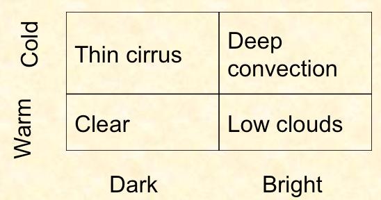
4 Visible & IR for cloud detection and classification IR Warm Cold Thin cirrus Clear Deep convection Low clouds Dark Bright visible
5
6 High cloud (make the image colder) Schematic for Water vapor Wet condition (cold) Dry condition (warm) Low cloud ( invisible ) Surface is not visible in the water vapor channel Temperature
7
 while clouds reflect NIR.")
8 0.5 µm, visible (solar only): both clouds and snow are bright. 3.7 µm, NIR More example on multi-spectral analysis: low clouds over bright background Snow strongly absorbs NIR (from the Sun) while clouds reflect NIR. Darker colors mean higher energy received by satellite (higher brightness temperature). 11 µm, IR (terrestrial only): similar emission temperatures for low clouds and snow
9 The three most common channels on meteorological satellites are: 1) visible (~ 0.6 µm) 2) infrared (~ 11 µm) 3) water vapor (~ 6.7 µm) visible water vapor Infrared (window)


10 MODIS 1.38-µm channel for detecting thin cirrus Cirrus cloud obvious in new 1.38 micron channel, previously undetected Probably from airplane contrail MAS image by Paul Menzel, CIMMS
11 1.38 micron is a both scattering and absorption channel High clouds Water vapor absorbs at 1.38 micron Low clouds
12 Outline 1. Traditional satellite images: visible, IR and water vapor 2. Microwave images for retrieving precipitation
13 The Microwave Spectrum Precipitation is measured in atmospheric windows (so that gaseous absorption won t get mixed into the problem) SSM/I, AMSR-E
14 A Few Facts Scattering coefficient Absorption coefficient Ice essentially does not absorb MW radiation; it only scatters Liquid drops both absorb and scatter, but absorption dominates Scattering and absorption both increase with frequency and with rain rate. Scattering by ice increases much more rapidly. 19, 37, 85 GHz
15 Two Conclusions Below 22 GHz, absorption is the primary mechanism affecting MW radiative transfer in precipitation Above 60 GHz, scattering dominates absorption; At different frequencies, MW radiometers observe different parts of the rain structure: Below 22 GHz, it responds directly to the rain layer; Above 60 GHz, it senses the ice aloft.
16 Absorption-based scheme (ignore scattering for now) T s ε Tr T c (1-Tr) Low frequency T c (1-Tr)(1-ε)Tr c.f. IR radiative transfer. ε is 1 so there is no reflected portion. Absorb or transmit Absorb or reflect T c Tr T s ε Tr: cloud transmittance; (1-Tr) emissivity ε: surface emissivity; (1- ε): surface reflectance
![T sat = T s εtr + T c (1 Tr) + T c (1 Tr)(1 ε)tr Low frequency = T c [1+ ε( T s T c 1)Tr (1 ε)tr 2 ] T c [1 (1 ε)tr 2 ] Important diff.](/docs-images/90/101993961/images/17-0.jpg "b/w land & ocean Ocean: ε ~ 0.")
17 T sat = T s εtr + T c (1 Tr) + T c (1 Tr)(1 ε)tr Low frequency = T c [1+ ε( T s T c 1)Tr (1 ε)tr 2 ] T c [1 (1 ε)tr 2 ] Important diff. b/w land & ocean Ocean: ε ~ 0.5 Land: ε ~ 1 T s T c = 300 K No rain (Tr=1) T sat Lots of rain (Tr=0) Ocean 150 K 300 K Land 300 K 300 K Ocean presents a cold background; rain appears warm
18 This half is IR image Low frequency Ocean: cold Rain: warm T sat T c [1 (1 ε)tr 2 ] Tr is related to rainfall
19 High frequency scattering Ice Large ice particles will decrease the brightness temperature (depression). Absorb or transmit Water T c Tr This is a major difference from IR radiative transfer, where scattering is negligible. Absorb or reflect Tr: cloud emissivity; (1-Tr) transmittance T s ε ε: surface emissivity; (1- ε): surface reflectance
20 High frequency Cold due to ice scattering (related to rainfall, albeit indirectly). Large amount of ice is indicative of deep convection.

21 High frequency Low emissivity of the ocean and scattering by ice cloud can both cause cold temperature. How to solve the ambiguity? Ocean Ice scattering
22 High frequency Polarization Corrected Temperature (PCT): PCT = at v -bt H, where a-b=1 Emissivity of surface water body (e.g. ocean or lake) is a function of polarization (hor. & ver. components of the electric field). Scattering by ice has very little polarization effect Spencer et al. 1989
23 High frequency Emissivity of surface water body (e.g. ocean or lake) is a function of polarization (hor. & ver. components of the electric field). Scattering by ice has very little polarization effect


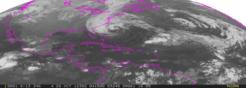
24 Red is ambiguous High frequency Hurricane Bonnie (1998) PCT
; appears")
25 37 GHz, sensitive to rain (lower level); appears warm compared to cold ocean 89 GHz, sensitive to ice (upper level); appears cold; ambiguous with cold ocean Putting MW images together 89 GHz PCT, sensitive to ice (upper level); appears cold

26
27
28 For visible/ir/water images,
29
30
31
Lecture 19: Operational Remote Sensing in Visible, IR, and Microwave Channels
 MET 4994 Remote Sensing: Radar and Satellite Meteorology MET 5994 Remote Sensing in Meteorology Lecture 19: Operational Remote Sensing in Visible, IR, and Microwave Channels Before you use data from any
Remote Sensing of Precipitation
 Lecture Notes Prepared by Prof. J. Francis Spring 2003 Remote Sensing of Precipitation Primary reference: Chapter 9 of KVH I. Motivation -- why do we need to measure precipitation with remote sensing instruments?
Lecture 4b: Meteorological Satellites and Instruments. Acknowledgement: Dr. S. Kidder at Colorado State Univ.
 Lecture 4b: Meteorological Satellites and Instruments Acknowledgement: Dr. S. Kidder at Colorado State Univ. US Geostationary satellites - GOES (Geostationary Operational Environmental Satellites) US
Interpretation of Polar-orbiting Satellite Observations. Atmospheric Instrumentation
 Interpretation of Polar-orbiting Satellite Observations Outline Polar-Orbiting Observations: Review of Polar-Orbiting Satellite Systems Overview of Currently Active Satellites / Sensors Overview of Sensor
Lecture 4: Radiation Transfer
 Lecture 4: Radiation Transfer Spectrum of radiation Stefan-Boltzmann law Selective absorption and emission Reflection and scattering Remote sensing Importance of Radiation Transfer Virtually all the exchange
REMOTE SENSING OF THE ATMOSPHERE AND OCEANS
 EAS 6145 SPRING 2007 REMOTE SENSING OF THE ATMOSPHERE AND OCEANS Instructor: Prof. Irina N. Sokolik office 2258, phone 404-894-6180 isokolik@eas.gatech.edu Meeting Time: Mondays: 3:05-4:25 PM Wednesdays:
F O U N D A T I O N A L C O U R S E
 F O U N D A T I O N A L C O U R S E December 6, 2018 Satellite Foundational Course for JPSS (SatFC-J) F O U N D A T I O N A L C O U R S E Introduction to Microwave Remote Sensing (with a focus on passive
Topics: Visible & Infrared Measurement Principal Radiation and the Planck Function Infrared Radiative Transfer Equation
 Review of Remote Sensing Fundamentals Allen Huang Cooperative Institute for Meteorological Satellite Studies Space Science & Engineering Center University of Wisconsin-Madison, USA Topics: Visible & Infrared
Climate Dynamics (PCC 587): Feedbacks & Clouds
: Feedbacks & Clouds") Climate Dynamics (PCC 587): Feedbacks & Clouds DARGAN M. W. FRIERSON UNIVERSITY OF WASHINGTON, DEPARTMENT OF ATMOSPHERIC SCIENCES DAY 6: 10-14-13 Feedbacks Climate forcings change global temperatures directly
Climate Dynamics (PCC 587): Feedbacks & Clouds DARGAN M. W. FRIERSON UNIVERSITY OF WASHINGTON, DEPARTMENT OF ATMOSPHERIC SCIENCES DAY 6: 10-14-13 Feedbacks Climate forcings change global temperatures directly
Introduction to Electromagnetic Radiation and Radiative Transfer
 Introduction to Electromagnetic Radiation and Radiative Transfer Temperature Dice Results Visible light, infrared (IR), ultraviolet (UV), X-rays, γ-rays, microwaves, and radio are all forms of electromagnetic
Monitoring Climate Change from Space
 Monitoring Climate Change from Space Richard Allan (email: r.p.allan@reading.ac.uk twitter: @rpallanuk) Department of Meteorology, University of Reading Why Monitor Earth s Climate from Space? Global Spectrum
D. Cimini*, V. Cuomo*, S. Laviola*, T. Maestri, P. Mazzetti*, S. Nativi*, J. M. Palmer*, R. Rizzi and F. Romano*
 D. Cimini*, V. Cuomo*, S. Laviola*, T. Maestri, P. Mazzetti*, S. Nativi*, J. M. Palmer*, R. Rizzi and F. Romano* * Istituto di Metodologie per l Analisi Ambientale, IMAA/CNR, Potenza, Italy ADGB - Dip.
New capabilities with high resolution cloud micro-structure facilitated by MTG 2.3 um channel
 Slide 19 November 2016, V1.0 New capabilities with high resolution cloud micro-structure facilitated by MTG 2.3 um channel Author: Daniel Rosenfeld The Hebrew University of Jerusalem (HUJ) daniel.rosenfeld@huji.ac.il
Day Microphysics RGB Nephanalysis in daytime. Meteorological Satellite Center, JMA
 Day Microphysics RGB Nephanalysis in daytime Meteorological Satellite Center, JMA What s Day Microphysics RGB? R : B04 (N1 0.86) Range : 0~100 [%] Gamma : 1.0 G : B07(I4 3.9) (Solar component) Range :
Study of the Influence of Thin Cirrus Clouds on Satellite Radiances Using Raman Lidar and GOES Data
 Study of the Influence of Thin Cirrus Clouds on Satellite Radiances Using Raman Lidar and GOES Data D. N. Whiteman, D. O C. Starr, and G. Schwemmer National Aeronautics and Space Administration Goddard
,Solar Energy, Greenhouse effect, Convection.notebook October 31, 2016
 Essential Question: How is weather created? What is Solar Energy? The driving source of energy for Earth. 1. Heats Earth's land, water, and air. 2. Causes movement in the atmosphere. Key Topics: The sun
Energy and the Earth AOSC 200 Tim Canty
 Energy and the Earth AOSC 200 Tim Canty Class Web Site: http://www.atmos.umd.edu/~tcanty/aosc200 Topics for today: Energy absorption Radiative Equilibirum Lecture 08 Feb 21 2019 1 Today s Weather Map http://www.wpc.ncep.noaa.gov/sfc/namussfcwbg.gif
Advanced Satellite Remote Sensing: Microwave Remote Sensing. August 11, 2011
 Advanced Satellite Remote Sensing: Microwave Remote Sensing FIU HRSSERP Internship August 11, 2011 What can Microwave Satellites Measure? Ocean Surface Wind Speed SeaIce Concentration, Edge, and age Precipitation
Climate & Earth System Science. Introduction to Meteorology & Climate. Chapter 05 SOME OBSERVING INSTRUMENTS. Instrument Enclosure.
 Climate & Earth System Science Introduction to Meteorology & Climate MAPH 10050 Peter Lynch Peter Lynch Meteorology & Climate Centre School of Mathematical Sciences University College Dublin Meteorology
Remote Sensing in Meteorology: Satellites and Radar. AT 351 Lab 10 April 2, Remote Sensing
 Remote Sensing in Meteorology: Satellites and Radar AT 351 Lab 10 April 2, 2008 Remote Sensing Remote sensing is gathering information about something without being in physical contact with it typically
Principles of Radiative Transfer Principles of Remote Sensing. Marianne König EUMETSAT
 - Principles of Radiative Transfer Principles of Remote Sensing Marianne König EUMETSAT marianne.koenig@eumetsat.int Remote Sensing All measurement processes which perform observations/measurements of
Description of Precipitation Retrieval Algorithm For ADEOS II AMSR
 Description of Precipitation Retrieval Algorithm For ADEOS II Guosheng Liu Florida State University 1. Basic Concepts of the Algorithm This algorithm is based on Liu and Curry (1992, 1996), in which the
Lecture 4: Meteorological Satellites and Instruments. Acknowledgement: Dr. S. Kidder at Colorado State Univ.
 Lecture 4: Meteorological Satellites and Instruments Acknowledgement: Dr. S. Kidder at Colorado State Univ. Homework for the Spring Break: get some tangible, preliminary results for your final project.
Comparison of NASA AIRS and MODIS Land Surface Temperature and Infrared Emissivity Measurements from the EOS AQUA platform
 Comparison of NASA AIRS and MODIS Land Surface Temperature and Infrared Emissivity Measurements from the EOS AQUA platform Robert Knuteson, Steve Ackerman, Hank Revercomb, Dave Tobin University of Wisconsin-Madison
NOAA/NESDIS Tropical Web Page with LEO Satellite Products and Applications for Forecasters
 NOAA/NESDIS Tropical Web Page with LEO Satellite Products and Applications for Forecasters Sheldon Kusselson National Oceanic and Atmospheric Administration (NOAA) National Environmental Satellite Data
Physical Basics of Remote-Sensing with Satellites
 - Physical Basics of Remote-Sensing with Satellites Dr. K. Dieter Klaes EUMETSAT Meteorological Division Am Kavalleriesand 31 D-64295 Darmstadt dieter.klaes@eumetsat.int Slide: 1 EUM/MET/VWG/09/0162 MET/DK
Microwave Remote Sensing of Sea Ice
 Microwave Remote Sensing of Sea Ice What is Sea Ice? Passive Microwave Remote Sensing of Sea Ice Basics Sea Ice Concentration Active Microwave Remote Sensing of Sea Ice Basics Sea Ice Type Sea Ice Motion
Temperature (T) degrees Celsius ( o C) arbitrary scale from 0 o C at melting point of ice to 100 o C at boiling point of water Also (Kelvin, K) = o C
 degrees Celsius ( o C) arbitrary scale from 0 o C at melting point of ice to 100 o C at boiling point of water Also (Kelvin, K) = o C") 1 2 3 4 Temperature (T) degrees Celsius ( o C) arbitrary scale from 0 o C at melting point of ice to 100 o C at boiling point of water Also (Kelvin, K) = o C plus 273.15 0 K is absolute zero, the minimum
1 2 3 4 Temperature (T) degrees Celsius ( o C) arbitrary scale from 0 o C at melting point of ice to 100 o C at boiling point of water Also (Kelvin, K) = o C plus 273.15 0 K is absolute zero, the minimum
Snowfall Detection and Retrieval from Passive Microwave Satellite Observations. Guosheng Liu Florida State University
 Snowfall Detection and Retrieval from Passive Microwave Satellite Observations Guosheng Liu Florida State University Collaborators: Eun Kyoung Seo, Yalei You Snowfall Retrieval: Active vs. Passive CloudSat
APPLICATIONS WITH METEOROLOGICAL SATELLITES. W. Paul Menzel. Office of Research and Applications NOAA/NESDIS University of Wisconsin Madison, WI
 APPLICATIONS WITH METEOROLOGICAL SATELLITES by W. Paul Menzel Office of Research and Applications NOAA/NESDIS University of Wisconsin Madison, WI July 2004 Unpublished Work Copyright Pending TABLE OF CONTENTS
Lecture 13. Applications of passive remote sensing: Remote sensing of precipitation and clouds.
 Lecture 13. Applications of passive remote sensing: Remote sensing of precipitation and clouds. 1. Classification of remote sensing techniques to measure precipitation. 2. Visible and infrared remote sensing
Fluid Circulation Review. Vocabulary. - Dark colored surfaces absorb more energy.
 Fluid Circulation Review Vocabulary Absorption - taking in energy as in radiation. For example, the ground will absorb the sun s radiation faster than the ocean water. Air pressure Albedo - Dark colored
Climate 1: The Climate System
 Climate 1: The Climate System Prof. Franco Prodi Institute of Atmospheric Sciences and Climate National Research Council Via P. Gobetti, 101 40129 BOLOGNA SIF, School of Energy, Varenna, July 2014 CLIMATE
How to display RGB imagery by SATAID
 How to display RGB imagery by SATAID Akihiro SHIMIZU Meteorological Satellite Center (MSC), Japan Meteorological Agency (JMA) Ver. 2015110500 RGB imagery on SATAID SATAID software has a function of overlapping
A Time Lag Model to Estimate Rainfall Rate Based on GOES Data
 A Time Lag Model to Estimate Rainfall Rate Based on GOES Data Nazario D. Ramirez, Robert J. Kuligowski, and Joan M. Castro Octava Reunión Nacional de Percepción Remota y Sistemas Geográficos de Información
Applications of the SEVIRI window channels in the infrared.
 Applications of the SEVIRI window channels in the infrared jose.prieto@eumetsat.int SEVIRI CHANNELS Properties Channel Cloud Gases Application HRV 0.7 Absorption Scattering
Radiation and the atmosphere
 Radiation and the atmosphere Of great importance is the difference between how the atmosphere transmits, absorbs, and scatters solar and terrestrial radiation streams. The most important statement that
Earth: the Goldilocks Planet
 Earth: the Goldilocks Planet Not too hot (460 C) Fig. 3-1 Not too cold (-55 C) Wave properties: Wavelength, velocity, and? Fig. 3-2 Reviewing units: Wavelength = distance (meters or nanometers, etc.) Velocity
Sensitivity Study of the MODIS Cloud Top Property
 Sensitivity Study of the MODIS Cloud Top Property Algorithm to CO 2 Spectral Response Functions Hong Zhang a*, Richard Frey a and Paul Menzel b a Cooperative Institute for Meteorological Satellite Studies,
P1.23 HISTOGRAM MATCHING OF ASMR-E AND TMI BRIGHTNESS TEMPERATURES
 P1.23 HISTOGRAM MATCHING OF ASMR-E AND TMI BRIGHTNESS TEMPERATURES Thomas A. Jones* and Daniel J. Cecil Department of Atmospheric Science University of Alabama in Huntsville Huntsville, AL 1. Introduction
MAIN ATTRIBUTES OF THE PRECIPITATION PRODUCTS DEVELOPED BY THE HYDROLOGY SAF PROJECT RESULTS OF THE VALIDATION IN HUNGARY
 MAIN ATTRIBUTES OF THE PRECIPITATION PRODUCTS DEVELOPED BY THE HYDROLOGY SAF PROJECT RESULTS OF THE VALIDATION IN HUNGARY Eszter Lábó OMSZ-Hungarian Meteorological Service, Budapest, Hungary labo.e@met.hu
ATMOS 5140 Lecture 1 Chapter 1
 ATMOS 5140 Lecture 1 Chapter 1 Atmospheric Radiation Relevance for Weather and Climate Solar Radiation Thermal Infrared Radiation Global Heat Engine Components of the Earth s Energy Budget Relevance for
MESO-NH cloud forecast verification with satellite observation
 MESO-NH cloud forecast verification with satellite observation Jean-Pierre CHABOUREAU Laboratoire d Aérologie, University of Toulouse and CNRS, France http://mesonh.aero.obs-mip.fr/chaboureau/ DTC Verification
Atmospheric Measurements from Space
 Atmospheric Measurements from Space MPI Mainz Germany Thomas Wagner Satellite Group MPI Mainz Part 1: Basics Break Part 2: Applications Part 1: Basics of satellite remote sensing Why atmospheric satellite
Weather. Chapter Test A. Multiple Choice. Write the letter of the correct answer on the line at the left.
 Weather Chapter Test A Multiple Choice Write the letter of the correct answer on the line at the left. 1. The most dangerous aspect of a snowstorm is often the a. high winds. b. depth of snow. c. brightness.
Polar regions Temperate Regions Tropics High ( cirro ) 3-8 km 5-13 km 6-18 km Middle ( alto ) 2-4 km 2-7 km 2-8 km Low ( strato ) 0-2 km 0-2 km 0-2 km
 3-8 km 5-13 km 6-18 km Middle ( alto ) 2-4 km 2-7 km 2-8 km Low ( strato ) 0-2 km 0-2 km 0-2 km") Clouds and Climate Clouds (along with rain, snow, fog, haze, etc.) are wet atmospheric aerosols. They are made up of tiny spheres of water from 2-100 m which fall with terminal velocities of a few cm/sec.
Clouds and Climate Clouds (along with rain, snow, fog, haze, etc.) are wet atmospheric aerosols. They are made up of tiny spheres of water from 2-100 m which fall with terminal velocities of a few cm/sec.
Electromagnetic Radiation. Radiation and the Planetary Energy Balance. Electromagnetic Spectrum of the Sun
 Radiation and the Planetary Energy Balance Electromagnetic Radiation Solar radiation warms the planet Conversion of solar energy at the surface Absorption and emission by the atmosphere The greenhouse
Day Snow-Fog RGB Detection of low-level clouds and snow/ice covered area
 JMA Day Snow-Fog RGB Detection of low-level clouds and snow/ice covered area Meteorological Satellite Center, JMA What s Day Snow-Fog RGB? R : B04 (N1 0.86) Range : 0~100 [%] Gamma : 1.7 G : B05 (N2 1.6)
THE FEASIBILITY OF EXTRACTING LOWLEVEL WIND BY TRACING LOW LEVEL MOISTURE OBSERVED IN IR IMAGERY OVER CLOUD FREE OCEAN AREA IN THE TROPICS
 THE FEASIBILITY OF EXTRACTING LOWLEVEL WIND BY TRACING LOW LEVEL MOISTURE OBSERVED IN IR IMAGERY OVER CLOUD FREE OCEAN AREA IN THE TROPICS Toshiro Ihoue and Tetsuo Nakazawa Meteorological Research Institute
School on Modelling Tools and Capacity Building in Climate and Public Health April Remote Sensing
 2453-5 School on Modelling Tools and Capacity Building in Climate and Public Health 15-26 April 2013 Remote Sensing CECCATO Pietro International Research Institute for Climate and Society, IRI The Earth
Condensation: Dew, Fog and Clouds AT350
 Condensation: Dew, Fog and Clouds AT350 T=30 C Water vapor pressure=12mb What is Td? What is the sat. water vapor T=30 C Water vapor pressure=12mb What is Td? What is the sat. water vapor ~12/42~29% POLAR
Moisture, Clouds, and Precipitation: Clouds and Precipitation. Dr. Michael J Passow
 Moisture, Clouds, and Precipitation: Clouds and Precipitation Dr. Michael J Passow What Processes Lift Air? Clouds require three things: water vapor, a condensation nucleus, and cooling Cooling usually
Lecture 5: Greenhouse Effect
 Lecture 5: Greenhouse Effect S/4 * (1-A) T A 4 T S 4 T A 4 Wien s Law Shortwave and Longwave Radiation Selected Absorption Greenhouse Effect Global Energy Balance terrestrial radiation cooling Solar radiation
Blackbody radiation. Main Laws. Brightness temperature. 1. Concepts of a blackbody and thermodynamical equilibrium.
 Lecture 4 lackbody radiation. Main Laws. rightness temperature. Objectives: 1. Concepts of a blackbody, thermodynamical equilibrium, and local thermodynamical equilibrium.. Main laws: lackbody emission:
SNOWFALL RATE RETRIEVAL USING AMSU/MHS PASSIVE MICROWAVE DATA
 SNOWFALL RATE RETRIEVAL USING AMSU/MHS PASSIVE MICROWAVE DATA Huan Meng 1, Ralph Ferraro 1, Banghua Yan 2 1 NOAA/NESDIS/STAR, 5200 Auth Road Room 701, Camp Spring, MD, USA 20746 2 Perot Systems Government
A Microwave Snow Emissivity Model
 A Microwave Snow Emissivity Model Fuzhong Weng Joint Center for Satellite Data Assimilation NOAA/NESDIS/Office of Research and Applications, Camp Springs, Maryland and Banghua Yan Decision Systems Technologies
Lectures 7 and 8: 14, 16 Oct Sea Surface Temperature
 Lectures 7 and 8: 14, 16 Oct 2008 Sea Surface Temperature References: Martin, S., 2004, An Introduction to Ocean Remote Sensing, Cambridge University Press, 454 pp. Chapter 7. Robinson, I. S., 2004, Measuring
General Aspects I: What is a cloud?
 Cloud Detection General Aspects I: What is a cloud? I can tell you, if I see... A visible aggregate of minute water droplets and/or ice particles in the atmosphere above the earth s surface Global total
Course outline, objectives, workload, projects, expectations
 Course outline, objectives, workload, projects, expectations Introductions Remote Sensing Overview Elements of a remote sensing observing system 1. platform (satellite, surface, etc) 2. experimental design
8. Clouds and Climate
 8. Clouds and Climate 1. Clouds (along with rain, snow, fog, haze, etc.) are wet atmospheric aerosols. They are made up of tiny spheres of water from 2-100 m which fall with terminal velocities of a few
URSI-F Microwave Signatures Meeting 2010, Florence, Italy, October 4 8, Thomas Meissner Lucrezia Ricciardulli Frank Wentz
 URSI-F Microwave Signatures Meeting 2010, Florence, Italy, October 4 8, 2010 Wind Measurements from Active and Passive Microwave Sensors High Winds and Winds in Rain Thomas Meissner Lucrezia Ricciardulli
Satellite remote sensing of aerosols & clouds: An introduction
 Satellite remote sensing of aerosols & clouds: An introduction Jun Wang & Kelly Chance April 27, 2006 junwang@fas.harvard.edu Outline Principals in retrieval of aerosols Principals in retrieval of water
Weather & Climate. Sanjay S. Limaye Space Science & Engineering Center University of Wisconsin-Madison
 Weather & Climate Sanjay S. Limaye Space Science & Engineering Center University of Wisconsin-Madison 1 What is Weather? Webster s New Collegiate Dictionary: state of the atmosphere with respect to heat
A NEW METHOD OF RETRIEVAL OF WIND VELOCITY OVER THE SEA SURFACE IN TROPICAL CYCLONES OVER THE DATA OF MICROWAVE MEASUREMENTS. A.F.
 A NEW METHOD OF RETRIEVAL OF WIND VELOCITY OVER THE SEA SURFACE IN TROPICAL CYCLONES OVER THE DATA OF MICROWAVE MEASUREMENTS A.F. Nerushev Institute of Experimental Meteorology. 82 Lenin Ave., Obninsk,
Combining Satellite & Model Information for Snowfall Retrieval
 Combining Satellite & Model Information for Snowfall Retrieval Yoo-Jeong Noh Cooperative Institute for Research in the Atmosphere Colorado State University CIRA/Colorado State University 5th Annual CoRP
Weather is the of the Earth s atmosphere at a place and time. It is the movement of through the atmosphere o Energy comes from the
 Weather Notes Weather Weather is the of the Earth s atmosphere at a place and time It is the movement of through the atmosphere o Energy comes from the The sun is the force that weather The sun s energy
Maps and Remote Sensing AOSC 200 Tim Canty
 Maps and Remote Sensing AOSC 200 Tim Canty Class Web Site: http://www.atmos.umd.edu/~tcanty/aosc200 Topics for today: Weather Maps Radar Satellite Observations Lecture 04 Feb 7 2019 1 Today s Weather Map
Arctic Clouds and Radiation Part 2
 Arctic Clouds and Radiation Part 2 Glen Lesins Department of Physics and Atmospheric Science Dalhousie University Create Summer School, Alliston, July 2013 No sun Arctic Winter Energy Balance 160 W m -2
Judit Kerényi. OMSZ-Hungarian Meteorological Service P.O.Box 38, H-1525, Budapest Hungary Abstract
 Comparison of the precipitation products of Hydrology SAF with the Convective Rainfall Rate of Nowcasting-SAF and the Multisensor Precipitation Estimate of EUMETSAT Judit Kerényi OMSZ-Hungarian Meteorological
Microphysical Properties of Single and Mixed-Phase Arctic Clouds Derived From Ground-Based AERI Observations
 Microphysical Properties of Single and Mixed-Phase Arctic Clouds Derived From Ground-Based AERI Observations Dave Turner University of Wisconsin-Madison Pacific Northwest National Laboratory 8 May 2003
Unit 5 Lesson 3 How is Weather Predicted? Copyright Houghton Mifflin Harcourt Publishing Company
 Tracking the Weather Warm up 1 Why is it important to watch the weather forecast before traveling to another country? Tracking the Weather A meteorologist is a scientist who studies weather. Meteorologists
1. CLIMATOLOGY: 2. ATMOSPHERIC CHEMISTRY:
 What is meteorology? A. METEOROLOGY: an atmospheric science that studies the day to day changes in the atmosphere 1. ATMOSPHERE: the blanket of gas that surrounds the surface of Earth; the air 2. WEATHER:
The EarthCARE mission: An active view on aerosols, clouds and radiation
 The EarthCARE mission: An active view on aerosols, clouds and radiation T. Wehr, P. Ingmann, T. Fehr Heraklion, Crete, Greece 08/06/2015 EarthCARE is ESA s sixths Earth Explorer Mission and will be implemented
State of the art of satellite rainfall estimation
 State of the art of satellite rainfall estimation 3-year comparison over South America using gauge data, and estimates from IR, TRMM radar and passive microwave Edward J. Zipser University of Utah, USA
A) usually less B) dark colored and rough D) light colored with a smooth surface A) transparency of the atmosphere D) rough, black surface
 usually less B) dark colored and rough D) light colored with a smooth surface A) transparency of the atmosphere D) rough, black surface") 1. Base your answer to the following question on the diagram below which shows two identical houses, A and B, in a city in North Carolina. One house was built on the east side of a factory, and the other
1. Base your answer to the following question on the diagram below which shows two identical houses, A and B, in a city in North Carolina. One house was built on the east side of a factory, and the other
"Cloud and Rainfall Observations using Microwave Radiometer Data and A-priori Constraints" Christian Kummerow and Fang Wang Colorado State University
 "Cloud and Rainfall Observations using Microwave Radiometer Data and A-priori Constraints" Christian Kummerow and Fang Wang Colorado State University ECMWF-JCSDA Workshop Reading, England June 16-18, 2010
Christian Sutton. Microwave Water Radiometer measurements of tropospheric moisture. ATOC 5235 Remote Sensing Spring 2003
 Christian Sutton Microwave Water Radiometer measurements of tropospheric moisture ATOC 5235 Remote Sensing Spring 23 ABSTRACT The Microwave Water Radiometer (MWR) is a two channel microwave receiver used
Florida Content Standards Grade 6
 Florida Content Standards Grade 6 : Earth Systems and Patterns The scientific theory of the evolution of Earth states that changes in our planet are driven by the flow of energy and the cycling of matter
On the Satellite Determination of Multilayered Multiphase Cloud Properties. Science Systems and Applications, Inc., Hampton, Virginia 2
 JP1.10 On the Satellite Determination of Multilayered Multiphase Cloud Properties Fu-Lung Chang 1 *, Patrick Minnis 2, Sunny Sun-Mack 1, Louis Nguyen 1, Yan Chen 2 1 Science Systems and Applications, Inc.,
Inaugural University of Michigan Science Olympiad Tournament
 Inaugural University of Michigan Science Olympiad Tournament The test may be taken apart. Ties will be broken based on predetermined questions and quality of response. Remote Sensing Test length: 50 Minutes
Chapter 5 Light and Matter: Reading Messages from the Cosmos. 5.1 Light in Everyday Life. How do we experience light?
 Chapter 5 Light and Matter: Reading Messages from the Cosmos 5.1 Light in Everyday Life Our goals for learning: How do we experience light? How do light and matter interact? How do we experience light?
Lecture 5: Greenhouse Effect
 /30/2018 Lecture 5: Greenhouse Effect Global Energy Balance S/ * (1-A) terrestrial radiation cooling Solar radiation warming T S Global Temperature atmosphere Wien s Law Shortwave and Longwave Radiation
Unit: Weather Study Guide
 Name: Period: Unit: Weather Study Guide Define each vocabulary word on a separate piece of paper or index card. Weather Climate Temperature Wind chill Heat index Sky conditions UV index Visibility Wind
Comparison of cloud statistics from Meteosat with regional climate model data
 Comparison of cloud statistics from Meteosat with regional climate model data R. Huckle, F. Olesen, G. Schädler Institut für Meteorologie und Klimaforschung, Forschungszentrum Karlsruhe, Germany (roger.huckle@imk.fzk.de
Glaciology HEAT BUDGET AND RADIATION
 HEAT BUDGET AND RADIATION A Heat Budget 1 Black body radiation Definition. A perfect black body is defined as a body that absorbs all radiation that falls on it. The intensity of radiation emitted by a
Earth s Energy Budget: How Is the Temperature of Earth Controlled?
 1 NAME Investigation 2 Earth s Energy Budget: How Is the Temperature of Earth Controlled? Introduction As you learned from the reading, the balance between incoming energy from the sun and outgoing energy
Preface to the Second Edition. Preface to the First Edition
 Contents Preface to the Second Edition Preface to the First Edition iii v 1 Introduction 1 1.1 Relevance for Climate and Weather........... 1 1.1.1 Solar Radiation.................. 2 1.1.2 Thermal Infrared
Name(s) Period Date. Earth s Energy Budget: How Is the Temperature of Earth Controlled?
 Period Date. Earth s Energy Budget: How Is the Temperature of Earth Controlled?") Name(s) Period Date 1 Introduction Earth s Energy Budget: How Is the Temperature of Earth Controlled? As you learned from the reading, the balance between incoming energy from the sun and outgoing energy
Name(s) Period Date 1 Introduction Earth s Energy Budget: How Is the Temperature of Earth Controlled? As you learned from the reading, the balance between incoming energy from the sun and outgoing energy
Radiative Transfer in the Atmosphere
 Radiative Transfer in the Atmosphere Lectures in Brienza 19 Sep 2011 Paul Menzel UW/CIMSS/AOS Outline Radiation Definitions Planck Function Emission, Absorption, Scattering Radiative Transfer Equation
Classification of hydrometeors using microwave brightness. temperature data from AMSU-B over Iran
 Iranian Journal of Geophysics, Vol. 9, No. 5, 2016, Page 24-39 Classification of hydrometeors using microwave brightness temperature data from AMSU-B over Iran Abolhasan Gheiby 1* and Majid Azadi 2 1 Assistant
REMOTE SENSING KEY!!
 REMOTE SENSING KEY!! This is a really ugly cover page I m sorry. Name Key. Score / 100 Directions: You have 50 minutes to take this test. You may use a cheatsheet (2 pages), a non-graphing calculator,
Climate Dynamics (PCC 587): Clouds and Feedbacks
: Clouds and Feedbacks") Climate Dynamics (PCC 587): Clouds and Feedbacks D A R G A N M. W. F R I E R S O N U N I V E R S I T Y O F W A S H I N G T O N, D E P A R T M E N T O F A T M O S P H E R I C S C I E N C E S D A Y 7 : 1
Climate Dynamics (PCC 587): Clouds and Feedbacks D A R G A N M. W. F R I E R S O N U N I V E R S I T Y O F W A S H I N G T O N, D E P A R T M E N T O F A T M O S P H E R I C S C I E N C E S D A Y 7 : 1
Clouds, Precipitation and their Remote Sensing
 Clouds, Precipitation and their Remote Sensing Prof. Susanne Crewell AG Integrated Remote Sensing Institute for Geophysics and Meteorology University of Cologne Susanne Crewell, Kompaktkurs, Jülich 24.
Introduction. Sunny Partly Cloudy Cloudy. Flurries Snow Ice. Showers Thunderstorms Rain. High Pressure Low Pressure FRONTS. Cold Warm Stationary
 Introduction Weather can change from minute to minute, hour to hour, day to day, or season to season. Meteorologists are scientists who study Earth s atmosphere in order to predict these changes. Meteorologists
Satellite and Aircraft Observations of Snowfall Signature at Microwave Frequencies. Yoo-Jeong Noh and Guosheng Liu
 Satellite and Aircraft Observations of Snowfall Signature at Microwave Frequencies Yoo-Jeong Noh and Guosheng Liu Department of Meteorology, Florida State University Tallahassee, Florida, USA Corresponding
Energy, Temperature, & Heat. Energy, Temperature, & Heat. Temperature Scales 1/17/11
 Energy, Temperature, & Heat Energy is the ability to do work (push, pull, lift) on some form of matter. Chapter 2 Potential energy is the potential for work (mass x gravity x height) Kinetic energy is
Unit 4 Lesson 2 Clouds and Cloud Formation. Copyright Houghton Mifflin Harcourt Publishing Company
 Head in the Clouds What are clouds? A cloud is a collection of small water droplets or ice crystals that are suspended in the air. Clouds are visible because water droplets and ice crystals reflect light.
Spectral reflectance: When the solar radiation is incident upon the earth s surface, it is either
 Spectral reflectance: When the solar radiation is incident upon the earth s surface, it is either reflected by the surface, transmitted into the surface or absorbed and emitted by the surface. Remote sensing
Chapter 5 Light and Matter: Reading Messages from the Cosmos. How do we experience light? Colors of Light. How do light and matter interact?
 Chapter 5 Light and Matter: Reading Messages from the Cosmos How do we experience light? The warmth of sunlight tells us that light is a form of energy We can measure the amount of energy emitted by a
Solar Radiation and Environmental Biophysics Geo 827, MSU Jiquan Chen Oct. 6, 2015
 Solar Radiation and Environmental Biophysics Geo 827, MSU Jiquan Chen Oct. 6, 2015 1) Solar radiation basics 2) Energy balance 3) Other relevant biophysics 4) A few selected applications of RS in ecosystem