Ice fog: T~<-10C RHi>100%
|
|
|
- Martina Payne
- 5 years ago
- Views:
Transcription


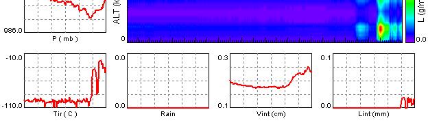
1 SATELLITE AND RADIOMETER BASED NOWCASTING APPLICATIONS FOR ARCTIC REGIONS Ismail Gultepe 1, Mike Pavolonis 2, Victor Chung 3, Corey Calvert 4, James Gurka 5, Randolf Ware 6, Louis Garand 7 G. Toth Aug Location Larsen Sound (south of Prince of Wales Island, west of the Boothia Peninsula, north of King William Island and east of Gateshead Island). FOG DEFINITIONS T>0C RHw>100% Warm fog Freez. fog: T~>-10C RHw~100% Cold fog Ice fog: T~<-10C RHi>100% 1
 [ice fog] USE GE")
, IR (10.")

2 FOG AND ICING ALGORITHMS USING GOES/MODIS OBSERVATIONS FRAM-YK (Yellowknife, Nov-2010/May-2011) [ice fog] USE GEM MODEL SIMULATIONS (E.G. SURFACE T, RH) USE GOES VIS, SW-IR (3.9 micron), IR (10.3 micron) CHANNELS, INCLUDING IR T APPLY DAY/NIGHT ALGORITHM (BECAUSE OF SW EFFECTS ON 3.9 MICRON CHANNEL) INTEGRATE ALL ABOVE FOR FINAL PRODUCTS SURFACE OBSERVATIONS AT THE SUPERSITE Yellowknife, NWT, Canada FRAM-YK (Yellowknife, Nov-2010/May-2011) [ice fog] 2


3 NOV 30 FREEZING FOG/DZ CASE DURING FRAM-ICE JAN 18 ICE FOG CASE DURING FRAM-ICE IF 3


4 ICE FOG CLOUD CEILING<3000 FT 4
5 SATELLITE APPLICATIONS GOES MODIS AVHRR VIIRS PCW (Future applications) GOES-R (Future applications) GOES-R ABI Bands Future GOES Imager (ABI) Band Wavelength Range (μm) Central Wavelength (μm) Sample Objective(s) Daytime aerosol-over-land, Color imagery Daytime clouds fog, insolation, winds Daytime vegetation & aerosol-over-water, winds Daytime cirrus cloud Daytime cloud water, snow Day land/cloud properties, particle size, vegetation Sfc. & cloud/fog at night, fire High-level atmospheric water vapor, winds, rainfall Mid-level atmospheric water vapor, winds, rainfall Lower-level water vapor, winds & SO Total water for stability, cloud phase, dust, SO Total ozone, turbulence, winds Surface properties, p low-level moisture & cloud Total water for SST, clouds, rainfall Total water & ash, SST Air temp & cloud heights and amounts 5
 MVFR - Marginal visual flight rules 1000 ft (305 m) < ceiling < 3000 ft (914 m) IFR - Instrument")
6 What Is FLS? Aviation-based fog/low stratus cloud definition VFR - Visual flight rules ceiling > 3000 ft (914 m) MVFR - Marginal visual flight rules 1000 ft (305 m) < ceiling < 3000 ft (914 m) IFR - Instrument flight rules 500 ft (152 m) < ceiling < 1000 ft (305 m) LIFR - Low instrument flight rules ceiling < 500 ft (152 m) The aviation flight rules above also include a visibility requirement, however, surface visibility is difficult to infer from satellites. Therefore, cloud ceiling is solely used to define fog and low stratus clouds. Impact of Satellite/NWP Fusion Gultepe et al (Mont.Weat.Rev.) With NWP RH as predictor (0.52) Without NWP as predictor (0.46) Traditional BTD technique (0.43) When boundary layer relative humidity information from the GFS is used as a predictor in the Bayes classifier, the maximum achievable skill score (Peirces s skill score) increases significantly 12 6

 for both Barrow,")


7 Barrow Notice how the traditional BTD FLS product would show the same signal (color) for both Barrow, Deadhorse, and Kaktovik Deadhorse Kaktovik MVFR Probability Barrow The GOES-R MVFR probability product indicates a < 50% probability of MVFR at Barrow and a > 50% probability of MVFR at Deadhorse and Kaktovik. In general, the GOES-R product is more sensitive than the BTD to localized changes in ceiling. Deadhorse Kaktovik 7


8 Yellowknife Yellowknife Yellowknife Yellowknife ABI channels 2, 7,14 Cloud Mask Cloud Phase Solar zenith angle Fused Fog/Low Cloud Detection Approach (future development) ABI VIIRS MVFR and IFR Probability Clear Sky RTM Output Data Fusion Using Naïve Bayesian Model -NWP Data (add additional fields -DEM -SST Data -Surface Emissivity Data 8

 and mesoscale NWP models. 3.")

9 CONCLUSIONS 1. Quantitatively compare GOES-R products to FRAM field experiment measurements (these measurements are critical) 2. Incorporate additional NWP fields (e.g. wind) and mesoscale NWP models. 3. Work towards an all weather MVFR and IFR probability capability 4. Elevated temperature inversions can cause false alarms 5. For opaque clouds, the cloud phase information only pertains to the top most portion of the cloud 6. Use Bayesian fused satellite/model approach to develop a shortterm prognostic product (short-term predictions on fog formation and dissipation) 9
Operational Uses of Bands on the GOES-R Advanced Baseline Imager (ABI) Presented by: Kaba Bah
 Presented by: Kaba Bah") Operational Uses of Bands on the GOES-R Advanced Baseline Imager (ABI) Presented by: Kaba Bah Topics: Introduction to GOES-R & ABI ABI individual bands Use of band differences ABI derived products Conclusions
Operational Uses of Bands on the GOES-R Advanced Baseline Imager (ABI) Presented by: Kaba Bah Topics: Introduction to GOES-R & ABI ABI individual bands Use of band differences ABI derived products Conclusions
Polar winds from highly elliptical orbiting satellites: a new perspective
 Polar winds from highly elliptical orbiting satellites: a new perspective 10 th International Winds Workshop Tokyo, Japan, Feb -6, 010 L. Garand 1, N. Wagneur 1, R. Sarrazin 1, D. Santek, J. Key 1 Environment
Day Microphysics RGB Nephanalysis in daytime. Meteorological Satellite Center, JMA
 Day Microphysics RGB Nephanalysis in daytime Meteorological Satellite Center, JMA What s Day Microphysics RGB? R : B04 (N1 0.86) Range : 0~100 [%] Gamma : 1.0 G : B07(I4 3.9) (Solar component) Range :
Himawari-8 True Color RGB
 Himawari-8 True Color RGB Meteorological Satellite Center, JMA Ver. 20150519 What s True Color RGB? R : B03(VS 0.64) G : B02(V2 0.51) 2015-03-17 00UTC B : B01(V1 0.46) Components of True Color RGB Channel
IDEA. from research to routine
 IDEA. from research to routine A collaboration between NASA, EPA, NOAA and CIMSS Cooperative Institute for Meteorological Satellite Studies Infusing satellite Data in Environmental Applications (IDEA)
How to display RGB imagery by SATAID
 How to display RGB imagery by SATAID Akihiro SHIMIZU Meteorological Satellite Center (MSC), Japan Meteorological Agency (JMA) Ver. 2015110500 RGB imagery on SATAID SATAID software has a function of overlapping
Preparation for Himawari 8
 Preparation for Himawari 8 Japan Meteorological Agency Meteorological Satellite Center Hidehiko MURATA ET SUP 8, WMO HQ, Geneva, 14 17 April 2014 1/18 Introduction Background The Japan Meteorological Agency
CLAVR-x is the Clouds from AVHRR Extended Processing System. Responsible for AVHRR cloud products and other products at various times.
 CLAVR-x in CSPP Andrew Heidinger, NOAA/NESDIS/STAR, Madison WI Nick Bearson, SSEC, Madison, WI Denis Botambekov, CIMSS, Madison, WI Andi Walther, CIMSS, Madison, WI William Straka III, CIMSS, Madison,
Ash RGB Detection of Volcanic Ash
 Copyright, JMA RGB Detection of Volcanic Meteorological Satellite Center, JMA Ver. 20150424 Volcanic Detection by Infrared and Difference Image, and Basis Himawari-8 B15-B13 2015-02-16 06:35 UTC Himawari-8
Usage of McIDAS V with GOES R AWG products
 McIDAS User Group Meeting, October 25-27, 2010, Madison, WI Usage of McIDAS V with GOES R AWG products William Straka III UW/CIMSS Madison, Wisconsin, USA With help from Tom Rink (CIMSS/), Tom Achtor (CIMSS/),
Atmospheric Moisture. Atmospheric Moisture:Clouds. Atmospheric Moisture:Clouds. Atmospheric Moisture:Clouds
 Sec A Atmospheric Moisture I. Measuring Relative Humidity A. A Psychrometer is an instrument for measuring relative humidity B. A common psychrometer uses two thermometers with a wet gauze wrapped over
P3.24 EVALUATION OF MODERATE-RESOLUTION IMAGING SPECTRORADIOMETER (MODIS) SHORTWAVE INFRARED BANDS FOR OPTIMUM NIGHTTIME FOG DETECTION
 SHORTWAVE INFRARED BANDS FOR OPTIMUM NIGHTTIME FOG DETECTION") P3.24 EVALUATION OF MODERATE-RESOLUTION IMAGING SPECTRORADIOMETER (MODIS) SHORTWAVE INFRARED BANDS FOR OPTIMUM NIGHTTIME FOG DETECTION 1. INTRODUCTION Gary P. Ellrod * NOAA/NESDIS/ORA Camp Springs, MD
P3.24 EVALUATION OF MODERATE-RESOLUTION IMAGING SPECTRORADIOMETER (MODIS) SHORTWAVE INFRARED BANDS FOR OPTIMUM NIGHTTIME FOG DETECTION 1. INTRODUCTION Gary P. Ellrod * NOAA/NESDIS/ORA Camp Springs, MD
Preparation for FY-4A. (Submitted by Xiang Fang, CMA)
") WORLD METEOROLOGICAL ORGANIZATION COMMISSION FOR BASIC SYSTEMS OPEN PROGRAMME AREA GROUP ON INTEGRATED OBSERVING SYSTEMS EXPERT TEAM ON SATELLITE UTILIZATION AND PRODUCTS ET-SUP-8/Doc. 10.3 (2.IV.2014)
WORLD METEOROLOGICAL ORGANIZATION COMMISSION FOR BASIC SYSTEMS OPEN PROGRAMME AREA GROUP ON INTEGRATED OBSERVING SYSTEMS EXPERT TEAM ON SATELLITE UTILIZATION AND PRODUCTS ET-SUP-8/Doc. 10.3 (2.IV.2014)
Applications of the SEVIRI window channels in the infrared.
 Applications of the SEVIRI window channels in the infrared jose.prieto@eumetsat.int SEVIRI CHANNELS Properties Channel Cloud Gases Application HRV 0.7 Absorption Scattering
Condensation: Dew, Fog, & Clouds. Chapter 5
 Condensation: Dew, Fog, & Clouds Chapter 5 The Formation of Dew & Frost Dew forms on objects near the ground surface when they cool below the dew point temperature. More likely on clear nights due to increased
McIDAS support of Suomi-NPP /JPSS and GOES-R L2
 McIDAS support of Suomi-NPP /JPSS and GOES-R L2 William Straka III 1 Tommy Jasmin 1, Bob Carp 1 1 Cooperative Institute for Meteorological Satellite Studies, Space Science and Engineering Center, University
Day Snow-Fog RGB Detection of low-level clouds and snow/ice covered area
 JMA Day Snow-Fog RGB Detection of low-level clouds and snow/ice covered area Meteorological Satellite Center, JMA What s Day Snow-Fog RGB? R : B04 (N1 0.86) Range : 0~100 [%] Gamma : 1.7 G : B05 (N2 1.6)
SAFNWC/MSG SEVIRI CLOUD PRODUCTS
 SAFNWC/MSG SEVIRI CLOUD PRODUCTS M. Derrien and H. Le Gléau Météo-France / DP / Centre de Météorologie Spatiale BP 147 22302 Lannion. France ABSTRACT Within the SAF in support to Nowcasting and Very Short
Interpretation of Polar-orbiting Satellite Observations. Atmospheric Instrumentation
 Interpretation of Polar-orbiting Satellite Observations Outline Polar-Orbiting Observations: Review of Polar-Orbiting Satellite Systems Overview of Currently Active Satellites / Sensors Overview of Sensor
MSG system over view
 MSG system over view 1 Introduction METEOSAT SECOND GENERATION Overview 2 MSG Missions and Services 3 The SEVIRI Instrument 4 The MSG Ground Segment 5 SAF Network 6 Conclusions METEOSAT SECOND GENERATION
Satellite-based Convection Nowcasting and Aviation Turbulence Applications
 Satellite-based Convection Nowcasting and Aviation Turbulence Applications Kristopher Bedka Cooperative Institute for Meteorological Satellite Studies (CIMSS), University of Wisconsin-Madison In collaboration
Current status of GK-2A AMV algorithm in NMSC/KMA
 Current status of GK-2A AMV algorithm in NMSC/KMA 23 April 2018 Soo Min Oh, Byung-il Lee, Sung-Rae Chung, Seonkyun Baek NMSC/KMA 국가기상위성센터 National Meteorological Satellite Center Contents Status of COMS
RGB Products: an easy and practical way to display multispectral satellite data (in combination with derived products)
") RGB Products: an easy and practical way to display multispectral satellite data (in combination with derived products) Dr. Jochen Kerkmann Training Officer EUMETSAT Multi-channel GEO satellites today Him-08
RGB Products: an easy and practical way to display multispectral satellite data (in combination with derived products) Dr. Jochen Kerkmann Training Officer EUMETSAT Multi-channel GEO satellites today Him-08
Moisture, Clouds, and Precipitation: Clouds and Precipitation. Dr. Michael J Passow
 Moisture, Clouds, and Precipitation: Clouds and Precipitation Dr. Michael J Passow What Processes Lift Air? Clouds require three things: water vapor, a condensation nucleus, and cooling Cooling usually
NESDIS Polar (Region) Products and Plans. Jeff Key NOAA/NESDIS Madison, Wisconsin USA
 Products and Plans. Jeff Key NOAA/NESDIS Madison, Wisconsin USA") NESDIS Polar (Region) Products and Plans Jeff Key NOAA/NESDIS Madison, Wisconsin USA WMO Polar Space Task Group, 2 nd meeting, Geneva, 12 14 June 2012 Relevant Missions and Products GOES R ABI Fractional
NESDIS Polar (Region) Products and Plans Jeff Key NOAA/NESDIS Madison, Wisconsin USA WMO Polar Space Task Group, 2 nd meeting, Geneva, 12 14 June 2012 Relevant Missions and Products GOES R ABI Fractional
Arctic Weather Every 10 Minutes: Design & Operation of ABI for PCW
 Arctic Weather Every 10 Minutes: Design and Operation of ABI for PCW Dr. Paul C. Griffith and Sue Wirth 31st Space Symposium, Technical Track, Colorado Springs, Colorado This document is not subject to
Meteorological Satellite Image Interpretations, Part III. Acknowledgement: Dr. S. Kidder at Colorado State Univ.
 Meteorological Satellite Image Interpretations, Part III Acknowledgement: Dr. S. Kidder at Colorado State Univ. Dates EAS417 Topics Jan 30 Introduction & Matlab tutorial Feb 1 Satellite orbits & navigation
Jun Park National Meteorological Satellite Center Korea Meteorological Administration
 KMA Implementation Plan for Satellite Climate products Jun Park National Meteorological Satellite Center Korea Meteorological Administration jun.park@kma.go.kr Outline 1. Introduction : Current & Future
WORLD S CHOICE FOR GEO IMAGING. Advanced Baseline Imager (ABI)
") WORLD S CHOICE FOR GEO IMAGING Advanced Baseline Imager (ABI) MARKET-LEADING EXPERTISE DELIVERS BEST-IN-CLASS WEATHER IMAGING In cases of extreme weather such as hurricanes, typhoons, blizzards and tornadoes,
WORLD S CHOICE FOR GEO IMAGING Advanced Baseline Imager (ABI) MARKET-LEADING EXPERTISE DELIVERS BEST-IN-CLASS WEATHER IMAGING In cases of extreme weather such as hurricanes, typhoons, blizzards and tornadoes,
Updated 12 Sep 2002 Talking Points for VISITview Lesson Fog Detection and Analysis With Satellite Data Gary Ellrod (NOAA/NESDIS) 1.
 1.") Updated 12 Sep 2002 Talking Points for VISITview Lesson Fog Detection and Analysis With Satellite Data Gary Ellrod (NOAA/NESDIS) 1. Title 2. Fog has a major impact on air safety and efficiency, and may
Updated 12 Sep 2002 Talking Points for VISITview Lesson Fog Detection and Analysis With Satellite Data Gary Ellrod (NOAA/NESDIS) 1. Title 2. Fog has a major impact on air safety and efficiency, and may
Future GOES (XGOHI, GOES-13/O/P, GOES-R+)
") Future GOES (XGOHI, GOES-13/O/P, GOES-R+) Timothy J. Schmit NOAA/NESDIS/Satellite Applications and Research Advanced Satellite Products Branch (ASPB) Madison, WI And many others MUG Meeting October 16,
Future GOES (XGOHI, GOES-13/O/P, GOES-R+) Timothy J. Schmit NOAA/NESDIS/Satellite Applications and Research Advanced Satellite Products Branch (ASPB) Madison, WI And many others MUG Meeting October 16,
Return periods of prolonged fog events in Canada
 Return periods of prolonged fog events in Canada 43th Annual Congress of the Canadian Meteorological and Oceanographic Society, Halifax, NS, 31 May 4 June 2009 Authors: Bjarne Hansen (Science and Technology
Temp 54 Dew Point 41 Relative Humidity 63%
 Temp 54 Dew Point 41 Relative Humidity 63% Water in the Atmosphere Evaporation Water molecules change from the liquid to gas phase Molecules in liquids move slowly Heat energy makes them move faster When
Satellite-Based Detection of Fog and Very Low Stratus
 Satellite-Based Detection of Fog and Very Low Stratus A High-Latitude Case Study Centred on the Helsinki Testbed Experiment J. Cermak 1, J. Kotro 2, O. Hyvärinen 2, V. Nietosvaara 2, J. Bendix 1 1: Laboratory
Fog Detection(FOG) Algorithm Theoretical Basis Document
 Algorithm Theoretical Basis Document") (FOG) (FOG-v1.0) NMSC/SCI/ATBD/FOG, Issue 1, rev.0 2012.12.12 National Meteorological Satellite Center REPORT SIGNATURE TABLE National Meteorological Satellite Center DOCUMENT CHANGE RECORD National Meteorological
(FOG) (FOG-v1.0) NMSC/SCI/ATBD/FOG, Issue 1, rev.0 2012.12.12 National Meteorological Satellite Center REPORT SIGNATURE TABLE National Meteorological Satellite Center DOCUMENT CHANGE RECORD National Meteorological
Fog detection product
 Fog detection product derived from RGB recipes Takumi Maruyama, Haruma Ishida and Koetsu Chubachi Meteorological Satellite Center / Japan Meteorological Agency Meteorological Research Institute / Japan
P2.9 Use of the NOAA ARL HYSPLIT Trajectory Model For the Short Range Prediction of Stratus and Fog
 Ellrod, G. P., 2013: Use of the NOAA ARL HYSPLIT Trajectory Model for the Short Range Prediction of Stratus and Fog. Extended Abstract, 38 th National Weather Association Annual Meeting, Charleston, SC,
Recent Update on MODIS C6 and VIIRS Deep Blue Aerosol Products
 Recent Update on MODIS C6 and VIIRS Deep Blue Aerosol Products N. Christina Hsu, Photo taken from Space Shuttle: Fierce dust front over Libya Corey Bettenhausen, Andrew M. Sayer, and Rick Hansell Laboratory
ECNU WORKSHOP LAB ONE 2011/05/25)
") ECNU WORKSHOP LAB ONE (Liam.Gumley@ssec.wisc.edu 2011/05/25) The objective of this laboratory exercise is to become familiar with the characteristics of MODIS Level 1B 1000 meter resolution data. After
ECNU WORKSHOP LAB ONE (Liam.Gumley@ssec.wisc.edu 2011/05/25) The objective of this laboratory exercise is to become familiar with the characteristics of MODIS Level 1B 1000 meter resolution data. After
Condensation Nuclei. Condensation Nuclei 2/10/11. Hydrophobic Water-repelling Oils, gasoline, paraffin Resist condensation, even above 100% RH
 Chapter 5 The Formation of Dew & Frost Dew forms on objects near the ground surface when they cool below the dew point temperature. More likely on clear nights due to increased radiative cooling White
Condensation: Dew, Fog and Clouds AT350
 Condensation: Dew, Fog and Clouds AT350 T=30 C Water vapor pressure=12mb What is Td? What is the sat. water vapor T=30 C Water vapor pressure=12mb What is Td? What is the sat. water vapor ~12/42~29% POLAR
A Time Lag Model to Estimate Rainfall Rate Based on GOES Data
 A Time Lag Model to Estimate Rainfall Rate Based on GOES Data Nazario D. Ramirez, Robert J. Kuligowski, and Joan M. Castro Octava Reunión Nacional de Percepción Remota y Sistemas Geográficos de Información
Once a specific data set is selected, NEO will list related data sets in the panel titled Matching Datasets, which is to the right of the image.
 NASA Earth Observations (NEO): A Brief Introduction NEO is a data visualization tool that allows users to explore a wealth of environmental data collected by NASA satellites. The satellites use an array
ASSIMILATION OF METAR CLOUD AND VISIBILITY OBSERVATIONS IN THE RUC
 9.13 ASSIMILATION OF METAR CLOUD AND VISIBILITY OBSERVATIONS IN THE RUC Stanley G. Benjamin, Stephen S. Weygandt, John M. Brown, Tracy Lorraine Smith 1, Tanya Smirnova 2, William R. Moninger, Barry Schwartz,
WATER IN THE ATMOSPHERE
 WATER IN THE ATMOSPHERE I. Humidity A. Defined as water vapor or moisture in the air (from evaporation and condensation). B. The atmosphere gains moisture from the evaporation of water from oceans, lakes,
Title Slide: AWIPS screengrab of AVHRR data fog product, cloud products, and POES sounding locations.
 Title Slide: AWIPS screengrab of AVHRR data fog product, cloud products, and POES sounding locations. Slide 2: 3 frames: Global tracks for NOAA19 (frame 1); NOAA-19 tracks over CONUS (frame 2); NOAA-19
Remote sensing with FAAM to evaluate model performance
 Remote sensing with FAAM to evaluate model performance YOPP-UK Workshop Chawn Harlow, Exeter 10 November 2015 Contents This presentation covers the following areas Introduce myself Focus of radiation research
Pilots watch the clouds, because clouds can indicate the kind of weather in store for a flight.
 Low stratus Cumulonimbus Pilots watch the clouds, because clouds can indicate the kind of weather in store for a flight. FILL IN THE BLANKS OR CIRCLE ONE: A. Stratus means flat or on one level. Low stratus
PHEOS - Weather, Climate, Air Quality
 Aerosol & cloud remote sensing over the Arctic : perspectives for the PHEMOS and meteorological imager payloads on the PCW mission Norm O Neill, Auromeet Saha, U. de Sherbrooke Chris E. Sioris, Jack McConnell,
General Aspects I: What is a cloud?
 Cloud Detection General Aspects I: What is a cloud? I can tell you, if I see... A visible aggregate of minute water droplets and/or ice particles in the atmosphere above the earth s surface Global total
Near Real-time Cloud Classification, Mesoscale Winds, and Convective Initiation Fields from MSG Data
 Near Real-time Cloud Classification, Mesoscale Winds, and Convective Initiation Fields from MSG Data Wayne Feltz *, J. Mecikalski, and K. Bedka * Cooperative Institute of Meteorological Satellite Studies
RGB Experts and Developers Workshop - Introduction Tokyo, Japan 7-9 Nov 2017
 RGB Experts and Developers Workshop - Introduction Tokyo, Japan 7-9 Nov 2017 Workshop Objectives Review of existing RGB standards Reconfirm and extend existing standards (new multi-spectral imagers) Stimulate
Lecture 4b: Meteorological Satellites and Instruments. Acknowledgement: Dr. S. Kidder at Colorado State Univ.
 Lecture 4b: Meteorological Satellites and Instruments Acknowledgement: Dr. S. Kidder at Colorado State Univ. US Geostationary satellites - GOES (Geostationary Operational Environmental Satellites) US
Comparison of NASA AIRS and MODIS Land Surface Temperature and Infrared Emissivity Measurements from the EOS AQUA platform
 Comparison of NASA AIRS and MODIS Land Surface Temperature and Infrared Emissivity Measurements from the EOS AQUA platform Robert Knuteson, Steve Ackerman, Hank Revercomb, Dave Tobin University of Wisconsin-Madison
Application of Himawari-8 AHI Data to the GOES-R Rainfall Rate Algorithm
 Application of Himawari-8 AHI Data to the GOES-R Rainfall Rate Algorithm Yaping Li 1, Robert Kuligowski 2 and Yan Hao 1 1. IMSG at NOAA/NESDIS/STAR 2. NOAA/NESDIS/STAR, College Park, MD 1 GOES-R Baseline
SATELLITE SIGNATURES ASSOCIATED WITH SIGNIFICANT CONVECTIVELY-INDUCED TURBULENCE EVENTS
 SATELLITE SIGNATURES ASSOCIATED WITH SIGNIFICANT CONVECTIVELY-INDUCED TURBULENCE EVENTS Kristopher Bedka 1, Wayne Feltz 1, John Mecikalski 2, Robert Sharman 3, Annelise Lenz 1, and Jordan Gerth 1 1 Cooperative
Name Class Date. 3. In what part of the water cycle do clouds form? a. precipitation b. evaporation c. condensation d. runoff
 Skills Worksheet Directed Reading B Section: Water in the Air 1. What do we call the condition of the atmosphere at a certain time and place? a. the water cycle b. weather c. climate d. precipitation THE
WEATHER. rain. thunder. The explosive sound of air as it is heated by lightning.
 WEATHER rain thunder The explosive sound of air as it is heated by lightning. rainbow lightning hurricane They are intense storms with swirling winds up to 150 miles per hour. tornado cold front warm front
CSPP Geo. CSPP/IMAPP Users Group Meeting 2015 Darmstadt, Germany 15 April 2015
 CSPP Geo Graeme Martin, Liam Gumley, Nick Bearson, Jessica Braun, Geoff Cureton, Ray Garcia, Tommy Jasmin, Scott Mindock, Kathy Strabala University of Wisconsin Madison, Space Science & Engineering Center
Basic cloud Interpretation using Satellite Imagery
 Basic cloud Interpretation using Satellite Imagery Introduction Recall that images from weather satellites are actually measurements of energy from specified bands within the Electromagnetic (EM) spectrum.
Weather Legends in FOREFLIGHT MOBILE
 Weather Legends in FOREFLIGHT MOBILE 14th Edition Covers ForeFlight Mobile v9.4 on ipad Radar Legends (when from Internet) Snowy/Icy Precipitation Mixed Precipitation Rain Echo top (in 100 s of feet) ex:
4.1 New Generation Satellite Data and Nowcasting Products: Himawari
 4.1 New Generation Satellite Data and Nowcasting Products: Himawari SCOPE-Nowcasting-EP 18-20 September 2017 Koji Yamashita kobo.yamashita@met.kishou.go.jp Meteorological Satellite Center (MSC) Japan Meteorological
ISSUED BY KENDRIYA VIDYALAYA - DOWNLOADED FROM
 CHAPTER -11 WATER IN THE ATMOSPHERE This chapter deals with Humidity, types of humidity, relative humidity, absolute humidity, specific humidity, dew point, condensation, saturated air, types of precipitation
Land Surface Temperature Measurements From the Split Window Channels of the NOAA 7 Advanced Very High Resolution Radiometer John C.
 Land Surface Temperature Measurements From the Split Window Channels of the NOAA 7 Advanced Very High Resolution Radiometer John C. Price Published in the Journal of Geophysical Research, 1984 Presented
Advancing Environmental Intelligence via Next-Generation Satellite Observations
 Advancing Environmental Intelligence via Next-Generation Satellite Observations Steven D. Miller Cooperative Institute for Research in the Atmosphere 11 th NOAA/NESDIS CoRP Science Symposium 16 September
Lectures 7 and 8: 14, 16 Oct Sea Surface Temperature
 Lectures 7 and 8: 14, 16 Oct 2008 Sea Surface Temperature References: Martin, S., 2004, An Introduction to Ocean Remote Sensing, Cambridge University Press, 454 pp. Chapter 7. Robinson, I. S., 2004, Measuring
THE FEASIBILITY OF EXTRACTING LOWLEVEL WIND BY TRACING LOW LEVEL MOISTURE OBSERVED IN IR IMAGERY OVER CLOUD FREE OCEAN AREA IN THE TROPICS
 THE FEASIBILITY OF EXTRACTING LOWLEVEL WIND BY TRACING LOW LEVEL MOISTURE OBSERVED IN IR IMAGERY OVER CLOUD FREE OCEAN AREA IN THE TROPICS Toshiro Ihoue and Tetsuo Nakazawa Meteorological Research Institute
Remote Sensing Seminar 8 June 2007 Benevento, Italy. Lab 5 SEVIRI and MODIS Clouds and Fires
 Remote Sensing Seminar 8 June 2007 Benevento, Italy Lab 5 SEVIRI and MODIS Clouds and Fires Table: SEVIRI Channel Number, Wavelength (µm), and Primary Application Reflective Bands 1,2 0.635, 0.81 land/cld
Dual-Regression Surface and Atmospheric Sounding Algorithm for Initializing Physical Retrievals and Direct Radiance Assimilation
 SPACE SCIENCE AND ENGINEERING CENTER Dual-Regression Surface and Atmospheric Sounding Algorithm for Initializing Physical Retrievals and Direct Radiance Assimilation W. L. Smith Sr. 1,2,3, E. Weisz 1,
Himawari-8/9 and GCOM-C Non-Meteorological Application Opportunities
 Himawari-8/9 and GCOM-C Non-Meteorological Application Opportunities Alex Held Centre for Australian Weather and Climate Research CAWCR December 2013 Selected materials from C. Down BoM) Non-Meteorological
Climates of NYS. Definitions. Climate Regions of NYS. Storm Tracks. Climate Controls 10/13/2011. Characteristics of NYS s Climates
 Definitions Climates of NYS Prof. Anthony Grande 2011 Weather and Climate Weather the state of the atmosphere at one point in time. The elements of weather are temperature, air pressure, wind and moisture.
Inferring Low Cloud Base Heights at Night for Aviation Using Satellite Infrared and Surface Temperature Data
 Pure appl. geophys. 164 (2007) 1193 1205 0033 4553/07/071193 13 DOI 10.1007/s00024-007-0214-7 Ó Birkhäuser Verlag, Basel, 2007 Pure and Applied Geophysics Inferring Low Cloud Base Heights at Night for
Warming Earth and its Atmosphere The Diurnal and Seasonal Cycles
 Warming Earth and its Atmosphere The Diurnal and Seasonal Cycles Or, what happens to the energy received from the sun? First We Need to Understand The Ways in Which Heat Can be Transferred in the Atmosphere
Added four (4) 8GB memory sticks. Wxnport1.db.erau.edu Added four (4) 4GB memory sticks o System memory increased to 24 gigabytes
 8GB memory sticks. Wxnport1.db.erau.edu Added four (4) 4GB memory sticks o System memory increased to 24 gigabytes") Infrastructure Enhancements to Support Educational Use of GOES-16 Christopher G. Herbster Robert E. Haley Meteorology Program Applied Aviation Sciences Embry-Riddle Aeronautical University Daytona Beach,
Infrastructure Enhancements to Support Educational Use of GOES-16 Christopher G. Herbster Robert E. Haley Meteorology Program Applied Aviation Sciences Embry-Riddle Aeronautical University Daytona Beach,
Satellite observation of atmospheric dust
 Satellite observation of atmospheric dust Taichu Y. Tanaka Meteorological Research Institute, Japan Meteorological Agency 11 April 2017, SDS WAS: Dust observation and modeling @WMO, Geneva Dust observations
Atmospheric Moisture. Relative humidity Clouds Rain/Snow. Relates to atmosphere, hydrosphere, biosphere, exosphere, geosphere
 Atmospheric Moisture Relative humidity Clouds Rain/Snow Relates to atmosphere, hydrosphere, biosphere, exosphere, geosphere Atmospheric moisture Water in the atmosphere Requires - vapor pressure- the amount
SATELLITE MONITORING OF THE CONVECTIVE STORMS
 SATELLITE MONITORING OF THE CONVECTIVE STORMS FORECASTERS POINT OF VIEW Michaela Valachová, EUMETSAT Workshop at ECMWF User Meeting Reading, 13 June 2017 Central Forecasting Office, Prague michaela.valachova@chmi.cz
GOES-R. Getting ready for the next generation earth observing system. Yuguang He AER April 10, 2015
 GOES-R Getting ready for the next generation earth observing system Yuguang He AER April 10, 2015 Outline! AER in research and applica0ons! AER on GOES- R! GOES- R: the next genera0on! Ge:ng ready for
Weather Legends in FOREFLIGHT MOBILE
 Weather Legends in FOREFLIGHT MOBILE 15th Edition Covers ForeFlight Mobile v9.6 on ipad Radar Legends (when from Internet) Snowy/Icy Precipitation Mixed Precipitation Rain Echo top (in 100 s of feet) ex:
Methodology for the creation of meteorological datasets for Local Air Quality modelling at airports
 Methodology for the creation of meteorological datasets for Local Air Quality modelling at airports Nicolas DUCHENE, James SMITH (ENVISA) Ian FULLER (EUROCONTROL Experimental Centre) About ENVISA Noise
ESCI 344 Tropical Meteorology Lesson 7 Temperature, Clouds, and Rain
 ESCI 344 Tropical Meteorology Lesson 7 Temperature, Clouds, and Rain References: Forecaster s Guide to Tropical Meteorology (updated), Ramage Tropical Climatology, McGregor and Nieuwolt Climate and Weather
Comparison of cloud statistics from Meteosat with regional climate model data
 Comparison of cloud statistics from Meteosat with regional climate model data R. Huckle, F. Olesen, G. Schädler Institut für Meteorologie und Klimaforschung, Forschungszentrum Karlsruhe, Germany (roger.huckle@imk.fzk.de
Steve Ackerman, R. Holz, R Frey, S. Platnick, A. Heidinger, and a bunch of others.
 Steve Ackerman, R. Holz, R Frey, S. Platnick, A. Heidinger, and a bunch of others. Outline Using CALIOP to Validate MODIS Cloud Detection, Cloud Height Assignment, Optical Properties Clouds and Surface
Joint Polar Satellite System. 3 rd Post-EPS User Consultation Workshop Mike Haas
 3 rd Post-EPS User Consultation Workshop Mike Haas Overview Introduction - Policy Drivers - Management System Description - Space Segment - Ground Segment Partnerships Status Benefits 2 Introduction (Policy
Weather. Describing Weather
 Weather Describing Weather What is weather? Weather is the atmospheric conditions, along with short-term changes, of a certain place at a certain time. Have you ever been caught in a rainstorm on what
Introduction of the Hyperspectral Environmental Suite (HES) on GOES-R and beyond
 on GOES-R and beyond") Introduction of the Hyperspectral Environmental Suite (HES) on GOES-R and beyond Timothy J. Schmit SaTellite Applications and Research (STAR) Advanced Satellite Products Team (ASPT) Presented by Jun Li
Introduction of the Hyperspectral Environmental Suite (HES) on GOES-R and beyond Timothy J. Schmit SaTellite Applications and Research (STAR) Advanced Satellite Products Team (ASPT) Presented by Jun Li
MSGVIEW: AN OPERATIONAL AND TRAINING TOOL TO PROCESS, ANALYZE AND VISUALIZATION OF MSG SEVIRI DATA
 MSGVIEW: AN OPERATIONAL AND TRAINING TOOL TO PROCESS, ANALYZE AND VISUALIZATION OF MSG SEVIRI DATA Aydın Gürol Ertürk Turkish State Meteorological Service, Remote Sensing Division, CC 401, Kalaba Ankara,
Introduction of JMA VLab Support Site on RGB Composite Imagery and tentative RGBs
 The Sixth Asia/Oceania Meteorological Satellite Users' Conference 9 13 November 2015, Tokyo/Japan J M A Introduction of JMA VLab Support Site on RGB Composite Imagery and tentative RGBs Akihiro SHIMIZU
a. Air is more dense b. Associated with cold air (more dense than warm air) c. Associated with sinking air
 c. Associated with sinking air") Meteorology 1. Air pressure the weight of air pressing down on Earth 2. Temperature and altitude determine air pressure 3. The more air particles are present, the more air density or pressure exists 4.
Meteorology 1. Air pressure the weight of air pressing down on Earth 2. Temperature and altitude determine air pressure 3. The more air particles are present, the more air density or pressure exists 4.
An Investigation of Reforecasting Applications for NGGPS Aviation Weather Prediction: An Initial Study of Ceiling and Visibility Prediction
 An Investigation of Reforecasting Applications for NGGPS Aviation Weather Prediction: An Initial Study of Ceiling and Visibility Prediction Kathryn L. Verlinden, Oregon State University David Bright, WFO
Answers to Clicker Questions
 Answers to Clicker Questions Chapter 1 What component of the atmosphere is most important to weather? A. Nitrogen B. Oxygen C. Carbon dioxide D. Ozone E. Water What location would have the lowest surface
Radiative Transfer Model based Bias Correction in INSAT-3D/3DR Thermal Observations to Improve Sea Surface Temperature Retrieval
 Radiative Transfer Model based Bias Correction in INSAT-3D/3DR Thermal Observations to Improve Sea Surface Temperature Retrieval Rishi K Gangwar, Buddhi P Jangid, and Pradeep K Thapliyal Space Applications
Observations of Integrated Water Vapor and Cloud Liquid Water at SHEBA. James Liljegren
 Observations of Integrated Water Vapor and Cloud Liquid Water at SHEBA James Liljegren Ames Laboratory Ames, IA 515.294.8428 liljegren@ameslab.gov Introduction In the Arctic water vapor and clouds influence
Surface temperature what does this data tell us about micro-meteorological processes?
 Surface temperature what does this data tell us about micro-meteorological processes? Prof. Dr. Eberhard Parlow Meteorology, Climatology and Remote Sensing (MCR Lab) Department of Environmental Sciences
EOS Direct Broadcast Real-Time Products for the US National Weather Service
 EOS Direct Broadcast Real-Time Products for the US National Weather Service Liam E. Gumley,, K. Strabala, J. Gerth,, S. Bachmeier, R. Dengel,, S. Dutcher, and J. Robaidek Liam.Gumley@ssec.wisc.edu University
Definitions Weather and Climate Climates of NYS Weather Climate 2012 Characteristics of Climate Regions of NYS NYS s Climates 1.
 Definitions Climates of NYS Prof. Anthony Grande 2012 Weather and Climate Weather the state of the atmosphere at one point in time. The elements of weather are temperature, t air pressure, wind and moisture.
Meteorology Today. 1 Aug st Lt Libby Haynes Capt Kim Mevers
 Meteorology 1950 - Today 1 Aug 2018 1 st Lt Libby Haynes Capt Kim Mevers What is meteorology? Is it important to you? Meteorology is the science of the atmosphere embracing both weather and climate. It
Weather and the Atmosphere. RAP Short Course
 Weather and the Atmosphere RAP Short Course Syllabus 1) Vertical structure and composition of the atmosphere, basic weather variables 2) Warming Earth and its atmosphere the diurnal and seasonal cycles
P3.13 GLOBAL COMPOSITE OF VOLCANIC ASH SPLIT ` WINDOW GEOSTATIONARY SATELLITE IMAGES
 P3.13 GLOBAL COMPOSITE OF VOLCANIC ASH SPLIT ` WINDOW GEOSTATIONARY SATELLITE IMAGES Frederick R. Mosher * Embry-Riddle Aeronautical University Daytona Beach, FL 1.0 Introduction Volcanic ash is exceptionally
VALIDATION OF INSAT-3D DERIVED RAINFALL. (Submitted by Suman Goyal, IMD) Summary and Purpose of Document
 Summary and Purpose of Document") WORLD METEOROLOGICAL ORGANIZATION COMMISSION FOR BASIC SYSTEMS OPEN PROGRAMME AREA GROUP ON INTEGRATED OBSERVING SYSTEMS INTER-PROGRAMME EXPERT TEAM ON SATELLITE UTILIZATION AND PRODUCTS SECOND SESSION
WORLD METEOROLOGICAL ORGANIZATION COMMISSION FOR BASIC SYSTEMS OPEN PROGRAMME AREA GROUP ON INTEGRATED OBSERVING SYSTEMS INTER-PROGRAMME EXPERT TEAM ON SATELLITE UTILIZATION AND PRODUCTS SECOND SESSION