Usage of McIDAS V with GOES R AWG products
|
|
|
- Maurice Robertson
- 5 years ago
- Views:
Transcription
1 McIDAS User Group Meeting, October 25-27, 2010, Madison, WI Usage of McIDAS V with GOES R AWG products William Straka III UW/CIMSS Madison, Wisconsin, USA With help from Tom Rink (CIMSS/), Tom Achtor (CIMSS/), and Tim Schmit (NOAA/NESDIS) 1
2 Acknowledgements We would like to acknowledge the efforts of several people in providing the data from the GOES R AIT framework for testing Walter Wolf 1, Shanna Sampson 2, Qingzhao Guo 2, Gang Fu 2, Aiwu Li 2, Meizhu Fan 2, Shuang Qiu 2, Zhaohui Cheng 2 1 NOAA/NESDIS/STAR 2 IMSG/Dell In addition, we would like to acknowledge the GOES R AWG teams who created these algorithms, EUMETSAT for the SEVIRI data and NASA EOS for the MODIS data. Further thanks goes to the GOES R Imagery AWG for providing the simulated AWG data and to Tom Rink for implementing the GOES R Fixed Grid Format in to McIDAS V 2
3 Status of GOES-R product Visualization in McIDAS-V Currently all of the 80% code delivery ABI Baseline Products are able to be visualized in McIDAS V As files from the 100% code delivery become available for the Baseline products, the output is being tested and visualized in McIDAS V. The Option 2 products, which are at their 80% code delivery are also being tested as they become available. Comments on any issues are then sent back to the GOES R AIT McIDAS V can visualize simulated ABI data in the GOES R Fixed Grid Format 3
4 Status of GOES-R product Visualization in McIDAS-V A request was sent in December 2010 to the GOES R AWG teams to gather enhancements for the various products. As they become available, the enhancements are tested and passed along to the McIDAS V team for integration into McIDAS V. The status of what enhancements have been integrated in available online to both the AIT as well as McIDAS V teams 4
5 ABI/GLM GOES-R product List Advanced Baseline Imager (ABI) BASELINE Products Clouds and Moisture Imagery (KPP) Clear Sky Mask Cloud Top Pressure and Height Cloud Top Phase Cloud Top Temperature Cloud Particle Size Distribution Cloud Optical Path Temperature and Moisture Profiles Total Precipitable Water Stability Parameters (Lifted Index) Aerosol Detection Aerosols Optical Depth Derived Motion Winds Hurricane Intensity Fire/Hot Spot Characterization Land and Sea Surface Temperature Volcanic Ash Rainfall Rate Snow Cover Downward Solar Insolation: Surface Reflected Solar Insolation: TOA Advanced Baseline Imager (ABI) OPTION 2 Products Cloud Layer/Heights Cloud Ice Water Path Cloud Liquid Water Cloud Type Convective Initiation Turbulence Low Cloud and Fog Enhanced V /Overshooting Top Aircraft Icing Threat SO 2 Detections (Volcanoes) Visibility Upward Longwave Radiation (TOA) Downward Longwave Radiation (SFC) Upward Longwave Radiation (SFC) Total Ozone Aerosol Particle Size Surface Emissivity Surface Albedo Vegetation Index Vegetation Fraction Flood Standing Water Rainfall probability and potential Snow Depth Ice Cover Sea & Lake Ice Concentration, Age, Extent, Motion Ocean Currents, Currents: Offshore GLM Lightning Detection 5

6 0.47 μm 0.64 μm 0.86 μm 1.38 μm 1.61 μm 2.26 μm 3.9 μm 6.19 μm 6.95 μm 7.34 μm 8.5 μm 9.61 μm μm 11.2 μm 12.3 μm 13.3 μm 6 NOAA/NESDIS STAR and GOES-R Imagery Team

7 GOES-R East (Simulated), FGF w/ lats included 75 W 7

8 GOES-R West (Simulated), FGF w/ lats included 137 W 8
")
9 Simulated GOES-R Displayed in Google Earth Image courtesy of NOAA/NESDIS STAR and GOES-R Imagery Team, Kaba Bah (CIMSS/) 9
10 GOES-R product images Most of the GOES R products have been using SEVIRI as a proxy dataset. Others have used MODIS or simulated data as a proxy data The following images show products either from the Framework runs of from PG efforts in order to demonstrate the enhancements and abilities of McIDAS V Unless otherwise noted, all images use data from the 80% code delivery 10

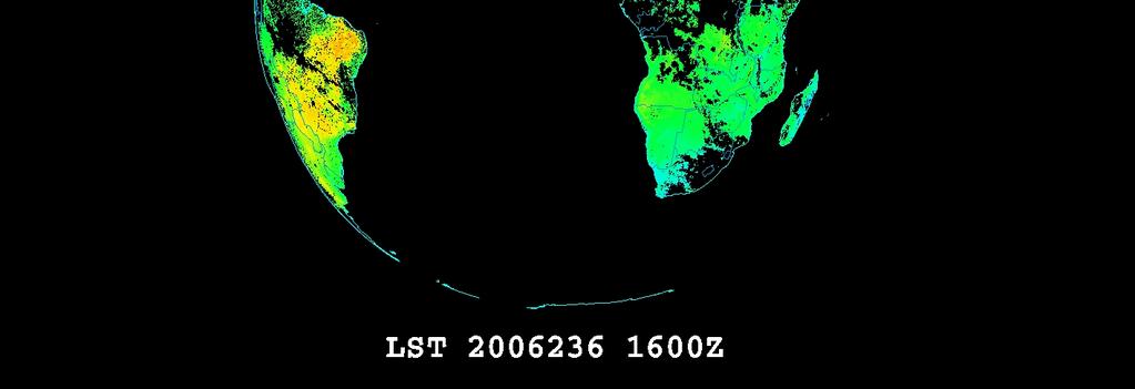
11 GOES-R LST K 11

12 GOES-R NDVI Clouds masked using ACM 12

13 GOES-R SST using regression technique Clouds masked using ACM 6/5/2008, 1200Z 13


14 GOES-R Rain Rate Algorithm mm/hr 14

15 GOES-R Ozone Clouds masked using ACM DU 15
16 GOES-R Upward Longwave Flux 16


17 GOES-R AMV Overlaid on 0.64 μm animation DU 17

18 GOES-R Snow Fraction Terra, 3/1/2009, 1740Z 18


19 GOES-R Shortwave Radiation Budget Terra, 8/24/2006, 1020Z 19

20 GOES-R Overshooting Tops Enhanced-V 4/7/2006, 1845Z Blue Overshooting Top Red Thermal Couplet 20

21 GOES-R Overshooting Tops Enhanced-V Proving Ground efforts Blue Overshooting Top Red Thermal Couplet 21

22 GOES-R Ice Concentration 2/5/2007, 0740Z 22

23 GOES-R 100% ACM 23

 EUMETSAT Ash Enhancement")
24 GOES-R Volcanic Ash Product 5/5/10 Eyjafjallajökull, Iceland Vol Ash Data provided by Michael Pavolonis (NOAA/NESDIS/STAR) EUMETSAT Ash Enhancement provided by Hans Peter, EUMETSAT 24
25 Other Simulated datasets McIDAS V has not only been used to visualize the GOES R AWG product, but has also been used to demonstrate the improved resolution capability of GOES R The usages of side by side panels is useful in demonstrating the resolution differences in the ABI resolution as compared to current GOES 25


26 Side by side analysis animation 4km vs 2km HRIT for MTSAT-1R Thanks to JMA for providing the 2km HRIT data /CIMSS/JMA 26

27 Side by side analysis 4km vs 2km HRIT for MTSAT-1R Thanks to JMA for providing the 2km HRIT data /CIMSS/JMA 27

28 Simulated ABI: Katrina GOES Imager GOES R ABI 28

29 Summary of ABI products in McIDAS-V All of the ABI Baseline Products are able to be visualized in McIDAS V We are currently working towards visualizing the GLM products as well. 29
30 Summary of ABI products in McIDAS-V As they become available, Option 2 products are being tested in McIDAS V We are making a concerted effort to gather the enhancements that are used by the various AWG teams. 30
31 Questions? 31
Operational Uses of Bands on the GOES-R Advanced Baseline Imager (ABI) Presented by: Kaba Bah
 Presented by: Kaba Bah") Operational Uses of Bands on the GOES-R Advanced Baseline Imager (ABI) Presented by: Kaba Bah Topics: Introduction to GOES-R & ABI ABI individual bands Use of band differences ABI derived products Conclusions
Operational Uses of Bands on the GOES-R Advanced Baseline Imager (ABI) Presented by: Kaba Bah Topics: Introduction to GOES-R & ABI ABI individual bands Use of band differences ABI derived products Conclusions
McIDAS support of Suomi-NPP /JPSS and GOES-R L2
 McIDAS support of Suomi-NPP /JPSS and GOES-R L2 William Straka III 1 Tommy Jasmin 1, Bob Carp 1 1 Cooperative Institute for Meteorological Satellite Studies, Space Science and Engineering Center, University
Future GOES (XGOHI, GOES-13/O/P, GOES-R+)
") Future GOES (XGOHI, GOES-13/O/P, GOES-R+) Timothy J. Schmit NOAA/NESDIS/Satellite Applications and Research Advanced Satellite Products Branch (ASPB) Madison, WI And many others MUG Meeting October 16,
Future GOES (XGOHI, GOES-13/O/P, GOES-R+) Timothy J. Schmit NOAA/NESDIS/Satellite Applications and Research Advanced Satellite Products Branch (ASPB) Madison, WI And many others MUG Meeting October 16,
CLAVR-x is the Clouds from AVHRR Extended Processing System. Responsible for AVHRR cloud products and other products at various times.
 CLAVR-x in CSPP Andrew Heidinger, NOAA/NESDIS/STAR, Madison WI Nick Bearson, SSEC, Madison, WI Denis Botambekov, CIMSS, Madison, WI Andi Walther, CIMSS, Madison, WI William Straka III, CIMSS, Madison,
Jun Park National Meteorological Satellite Center Korea Meteorological Administration
 KMA Implementation Plan for Satellite Climate products Jun Park National Meteorological Satellite Center Korea Meteorological Administration jun.park@kma.go.kr Outline 1. Introduction : Current & Future
Himawari-8/9 and GCOM-C Non-Meteorological Application Opportunities
 Himawari-8/9 and GCOM-C Non-Meteorological Application Opportunities Alex Held Centre for Australian Weather and Climate Research CAWCR December 2013 Selected materials from C. Down BoM) Non-Meteorological
Preparation for FY-4A. (Submitted by Xiang Fang, CMA)
") WORLD METEOROLOGICAL ORGANIZATION COMMISSION FOR BASIC SYSTEMS OPEN PROGRAMME AREA GROUP ON INTEGRATED OBSERVING SYSTEMS EXPERT TEAM ON SATELLITE UTILIZATION AND PRODUCTS ET-SUP-8/Doc. 10.3 (2.IV.2014)
WORLD METEOROLOGICAL ORGANIZATION COMMISSION FOR BASIC SYSTEMS OPEN PROGRAMME AREA GROUP ON INTEGRATED OBSERVING SYSTEMS EXPERT TEAM ON SATELLITE UTILIZATION AND PRODUCTS ET-SUP-8/Doc. 10.3 (2.IV.2014)
GOES-R. Getting ready for the next generation earth observing system. Yuguang He AER April 10, 2015
 GOES-R Getting ready for the next generation earth observing system Yuguang He AER April 10, 2015 Outline! AER in research and applica0ons! AER on GOES- R! GOES- R: the next genera0on! Ge:ng ready for
Preparation for Himawari 8
 Preparation for Himawari 8 Japan Meteorological Agency Meteorological Satellite Center Hidehiko MURATA ET SUP 8, WMO HQ, Geneva, 14 17 April 2014 1/18 Introduction Background The Japan Meteorological Agency
ABI and AIRS Retrievals in McIDAS-V
 ABI and AIRS Retrievals in McIDAS-V Kaba Bah Content Introduction to McIDAS V Introduction to GOES R ABI Visualize simulated ABI using McIDAS V Analyze simulated ABI using McIDAS V Introduction to AIRS
Application of Himawari-8 AHI Data to the GOES-R Rainfall Rate Algorithm
 Application of Himawari-8 AHI Data to the GOES-R Rainfall Rate Algorithm Yaping Li 1, Robert Kuligowski 2 and Yan Hao 1 1. IMSG at NOAA/NESDIS/STAR 2. NOAA/NESDIS/STAR, College Park, MD 1 GOES-R Baseline
CSPP Geo. CSPP/IMAPP Users Group Meeting 2015 Darmstadt, Germany 15 April 2015
 CSPP Geo Graeme Martin, Liam Gumley, Nick Bearson, Jessica Braun, Geoff Cureton, Ray Garcia, Tommy Jasmin, Scott Mindock, Kathy Strabala University of Wisconsin Madison, Space Science & Engineering Center
Himawari-8 True Color RGB
 Himawari-8 True Color RGB Meteorological Satellite Center, JMA Ver. 20150519 What s True Color RGB? R : B03(VS 0.64) G : B02(V2 0.51) 2015-03-17 00UTC B : B01(V1 0.46) Components of True Color RGB Channel
Once a specific data set is selected, NEO will list related data sets in the panel titled Matching Datasets, which is to the right of the image.
 NASA Earth Observations (NEO): A Brief Introduction NEO is a data visualization tool that allows users to explore a wealth of environmental data collected by NASA satellites. The satellites use an array
EOS Direct Broadcast Real-Time Products for the US National Weather Service
 EOS Direct Broadcast Real-Time Products for the US National Weather Service Liam E. Gumley,, K. Strabala, J. Gerth,, S. Bachmeier, R. Dengel,, S. Dutcher, and J. Robaidek Liam.Gumley@ssec.wisc.edu University
Ice fog: T~<-10C RHi>100%
 SATELLITE AND RADIOMETER BASED NOWCASTING APPLICATIONS FOR ARCTIC REGIONS Ismail Gultepe 1, Mike Pavolonis 2, Victor Chung 3, Corey Calvert 4, James Gurka 5, Randolf Ware 6, Louis Garand 7 G. Toth Aug
McIDAS Activities Within The NASA Langley Research Center Clouds And Radiation Group
 McIDAS Activities Within The NASA Langley Research Center Clouds And Radiation Group Kristopher Bedka Science Systems and Applications Inc @ NASA LaRC In Collaboration With (in alphabetical order) J. K.
The HIGHTSI ice model and plans in SURFEX
 Air Snow T in Ice with snow cover T sfc x T snow Q si F si h s h s The HIGHTSI ice model and plans in SURFEX Bin Cheng and Laura Rontu Water Ice T ice h i Finnish Meteorological Institute, FI-11 Helsinki,
McIDAS-X Software Development and Demonstration. PDA Animated Weather (PAW) Status by Russ Dengel. Dave Santek and Jay Heinzelman.
 Status by Russ Dengel. Dave Santek and Jay Heinzelman.") McIDAS-X Software Development and Demonstration Dave Santek and Jay Heinzelman 2 June 2009 PDA Animated Weather (PAW) Status by Russ Dengel Overview McIDAS-X 2008, 2009.1 McIDAS-XRD 2008, 2009.1 Software
McIDAS-X Software Development and Demonstration Dave Santek and Jay Heinzelman 2 June 2009 PDA Animated Weather (PAW) Status by Russ Dengel Overview McIDAS-X 2008, 2009.1 McIDAS-XRD 2008, 2009.1 Software
RGB Products: an easy and practical way to display multispectral satellite data (in combination with derived products)
") RGB Products: an easy and practical way to display multispectral satellite data (in combination with derived products) Dr. Jochen Kerkmann Training Officer EUMETSAT Multi-channel GEO satellites today Him-08
RGB Products: an easy and practical way to display multispectral satellite data (in combination with derived products) Dr. Jochen Kerkmann Training Officer EUMETSAT Multi-channel GEO satellites today Him-08
A 2016 CEOS Chair Initiative. Non-meteorological Applications for Next Generation Geostationary Satellites
 A 2016 CEOS Chair Initiative Committee on Earth Observation Satellites Non-meteorological Applications for Next Generation Geostationary Satellites Co-chaired by EUMETSAT (Holmlund), CSIRO (Schroeder),
Derivation of Ice Thickness and Age for Use with GOES-R ABI Data
 GOES-R AWG Cryosphere Team Derivation of Ice Thickness and Age for Use with GOES-R ABI Data Presented by: Xuanji Wang 1 Other team members: Jeff Key 2, Yinghui Liu 1 1 UW-Madison/CIMSS 2 NOAA/NESDIS/STAR
Current status of GK-2A AMV algorithm in NMSC/KMA
 Current status of GK-2A AMV algorithm in NMSC/KMA 23 April 2018 Soo Min Oh, Byung-il Lee, Sung-Rae Chung, Seonkyun Baek NMSC/KMA 국가기상위성센터 National Meteorological Satellite Center Contents Status of COMS
FUTURE PLAN AND RECENT ACTIVITIES FOR THE JAPANESE FOLLOW-ON GEOSTATIONARY METEOROLOGICAL SATELLITE HIMAWARI-8/9
 FUTURE PLAN AND RECENT ACTIVITIES FOR THE JAPANESE FOLLOW-ON GEOSTATIONARY METEOROLOGICAL SATELLITE HIMAWARI-8/9 Toshiyuki Kurino Japan Meteorological Agency, 1-3-4 Otemachi Chiyodaku, Tokyo 100-8122,
Using McIDAS-V for Satellite-Based Thunderstorm Research and Product Development
 Using McIDAS-V for Satellite-Based Thunderstorm Research and Product Development Kristopher Bedka UW-Madison, SSEC/CIMSS In Collaboration With: Tom Rink, Jessica Staude, Tom Whittaker, Wayne Feltz, and
How to display RGB imagery by SATAID
 How to display RGB imagery by SATAID Akihiro SHIMIZU Meteorological Satellite Center (MSC), Japan Meteorological Agency (JMA) Ver. 2015110500 RGB imagery on SATAID SATAID software has a function of overlapping
APPLICATIONS WITH METEOROLOGICAL SATELLITES. W. Paul Menzel. Office of Research and Applications NOAA/NESDIS University of Wisconsin Madison, WI
 APPLICATIONS WITH METEOROLOGICAL SATELLITES by W. Paul Menzel Office of Research and Applications NOAA/NESDIS University of Wisconsin Madison, WI July 2004 Unpublished Work Copyright Pending TABLE OF CONTENTS
Himawari-8 BUFR Development for Winds Processing and Radiances - Packaging for Algorithm Integration Team (AIT)
") Sandy Supplemental Grant Recipient Quarterly Progress Report Himawari-8 BUFR Development for Winds Processing and Radiances - Packaging for Algorithm Integration Team (AIT) Award Number: NA14NWS4830052
Sandy Supplemental Grant Recipient Quarterly Progress Report Himawari-8 BUFR Development for Winds Processing and Radiances - Packaging for Algorithm Integration Team (AIT) Award Number: NA14NWS4830052
Overview on GK-2A Data and Products
 SCOPE-Nowcasting EP-1 Overview on GK-2A Data and Products Jae-Dong Jang NMSC Geo-KOMPSAT-2A, AMI Sector Satellite in Orbit Operator Location Launch date Environmental payload and status GEO-KOMPSAT-2A
IDEA. from research to routine
 IDEA. from research to routine A collaboration between NASA, EPA, NOAA and CIMSS Cooperative Institute for Meteorological Satellite Studies Infusing satellite Data in Environmental Applications (IDEA)
An Overview of NOAA s Satellite, Data, and Information Stewardship Program
 An Overview of NOAA s Satellite, Data, and Information Stewardship Program John J. Bates and Mitch Goldberg National Oceanic and Atmospheric Administration National Environmental Satellite Data and Information
Advanced Infrared Sounding System for Future Geostationary Satellites
 Advanced Infrared Sounding System for Future Geostationary Satellites Timothy J. Schmit @, Jun Li # Hal Bloom &, James J. Gurka & Jaime Daniels @, Mitch Goldberg @ Steve Ackerman #, Paul Menzel #, and
Day Microphysics RGB Nephanalysis in daytime. Meteorological Satellite Center, JMA
 Day Microphysics RGB Nephanalysis in daytime Meteorological Satellite Center, JMA What s Day Microphysics RGB? R : B04 (N1 0.86) Range : 0~100 [%] Gamma : 1.0 G : B07(I4 3.9) (Solar component) Range :
Day Snow-Fog RGB Detection of low-level clouds and snow/ice covered area
 JMA Day Snow-Fog RGB Detection of low-level clouds and snow/ice covered area Meteorological Satellite Center, JMA What s Day Snow-Fog RGB? R : B04 (N1 0.86) Range : 0~100 [%] Gamma : 1.7 G : B05 (N2 1.6)
The PRECIS Regional Climate Model
 The PRECIS Regional Climate Model General overview (1) The regional climate model (RCM) within PRECIS is a model of the atmosphere and land surface, of limited area and high resolution and locatable over
Seeking a consistent view of energy and water flows through the climate system
 Seeking a consistent view of energy and water flows through the climate system Robert Pincus University of Colorado and NOAA/Earth System Research Lab Atmospheric Energy Balance [Wm -2 ] 340.1±0.1 97-101
4.1 New Generation Satellite Data and Nowcasting Products: Himawari
 4.1 New Generation Satellite Data and Nowcasting Products: Himawari SCOPE-Nowcasting-EP 18-20 September 2017 Koji Yamashita kobo.yamashita@met.kishou.go.jp Meteorological Satellite Center (MSC) Japan Meteorological
Interpretation of Polar-orbiting Satellite Observations. Atmospheric Instrumentation
 Interpretation of Polar-orbiting Satellite Observations Outline Polar-Orbiting Observations: Review of Polar-Orbiting Satellite Systems Overview of Currently Active Satellites / Sensors Overview of Sensor
WRF Model Simulated Proxy Datasets Used for GOES-R Research Activities
 WRF Model Simulated Proxy Datasets Used for GOES-R Research Activities Jason Otkin Cooperative Institute for Meteorological Satellite Studies Space Science and Engineering Center University of Wisconsin
VALIDATION OF INSAT-3D DERIVED RAINFALL. (Submitted by Suman Goyal, IMD) Summary and Purpose of Document
 Summary and Purpose of Document") WORLD METEOROLOGICAL ORGANIZATION COMMISSION FOR BASIC SYSTEMS OPEN PROGRAMME AREA GROUP ON INTEGRATED OBSERVING SYSTEMS INTER-PROGRAMME EXPERT TEAM ON SATELLITE UTILIZATION AND PRODUCTS SECOND SESSION
WORLD METEOROLOGICAL ORGANIZATION COMMISSION FOR BASIC SYSTEMS OPEN PROGRAMME AREA GROUP ON INTEGRATED OBSERVING SYSTEMS INTER-PROGRAMME EXPERT TEAM ON SATELLITE UTILIZATION AND PRODUCTS SECOND SESSION
GOES-R Overview and Status
 GOES-R Overview and Status Tom Renkevens NOAA s Satellite and Information Service McIDAS Users Group 2005 October 27, 2005 1 Outline Purpose GOES Background Requirements Instrument Summary Notional Architecture
Ash RGB Detection of Volcanic Ash
 Copyright, JMA RGB Detection of Volcanic Meteorological Satellite Center, JMA Ver. 20150424 Volcanic Detection by Infrared and Difference Image, and Basis Himawari-8 B15-B13 2015-02-16 06:35 UTC Himawari-8
Satellite-based Convection Nowcasting and Aviation Turbulence Applications
 Satellite-based Convection Nowcasting and Aviation Turbulence Applications Kristopher Bedka Cooperative Institute for Meteorological Satellite Studies (CIMSS), University of Wisconsin-Madison In collaboration
An update on CMIP(6), obs4mips and the WGCM/WGNE Diagnostics and Metrics Panel
, obs4mips and the WGCM/WGNE Diagnostics and Metrics Panel") An update on CMIP(6), obs4mips and the WGCM/WGNE Diagnostics and Metrics Panel Peter J. Gleckler WGNE 31, Pretoria, South Africa, April 27, 2016 REMOTE PRESENTATION Talk outline 2 CMIP6 status obs4mips
An update on CMIP(6), obs4mips and the WGCM/WGNE Diagnostics and Metrics Panel Peter J. Gleckler WGNE 31, Pretoria, South Africa, April 27, 2016 REMOTE PRESENTATION Talk outline 2 CMIP6 status obs4mips
P1.34 MULTISEASONALVALIDATION OF GOES-BASED INSOLATION ESTIMATES. Jason A. Otkin*, Martha C. Anderson*, and John R. Mecikalski #
 P1.34 MULTISEASONALVALIDATION OF GOES-BASED INSOLATION ESTIMATES Jason A. Otkin*, Martha C. Anderson*, and John R. Mecikalski # *Cooperative Institute for Meteorological Satellite Studies, University of
Lecture 4b: Meteorological Satellites and Instruments. Acknowledgement: Dr. S. Kidder at Colorado State Univ.
 Lecture 4b: Meteorological Satellites and Instruments Acknowledgement: Dr. S. Kidder at Colorado State Univ. US Geostationary satellites - GOES (Geostationary Operational Environmental Satellites) US
Current capabilities and limitations of satellite monitoring and modeling forecasting of volcanic clouds: and example of Eyjafjallaj
 Current capabilities and limitations of satellite monitoring and modeling forecasting of volcanic clouds: and example of Eyjafjallaj fjallajökull eruption (pronounced EYE-a-fyat fyat-la-jo-kotl) N. Krotkov
NESDIS Polar (Region) Products and Plans. Jeff Key NOAA/NESDIS Madison, Wisconsin USA
 Products and Plans. Jeff Key NOAA/NESDIS Madison, Wisconsin USA") NESDIS Polar (Region) Products and Plans Jeff Key NOAA/NESDIS Madison, Wisconsin USA WMO Polar Space Task Group, 2 nd meeting, Geneva, 12 14 June 2012 Relevant Missions and Products GOES R ABI Fractional
NESDIS Polar (Region) Products and Plans Jeff Key NOAA/NESDIS Madison, Wisconsin USA WMO Polar Space Task Group, 2 nd meeting, Geneva, 12 14 June 2012 Relevant Missions and Products GOES R ABI Fractional
5. General Circulation Models
 5. General Circulation Models I. 3-D Climate Models (General Circulation Models) To include the full three-dimensional aspect of climate, including the calculation of the dynamical transports, requires
Introduction of the Hyperspectral Environmental Suite (HES) on GOES-R and beyond
 on GOES-R and beyond") Introduction of the Hyperspectral Environmental Suite (HES) on GOES-R and beyond Timothy J. Schmit SaTellite Applications and Research (STAR) Advanced Satellite Products Team (ASPT) Presented by Jun Li
Introduction of the Hyperspectral Environmental Suite (HES) on GOES-R and beyond Timothy J. Schmit SaTellite Applications and Research (STAR) Advanced Satellite Products Team (ASPT) Presented by Jun Li
The ABI (Advanced Baseline Imager) on the GOES-R series
 on the GOES-R series") The ABI (Advanced Baseline Imager) on the GOES-R series Timothy J. Schmit NOAA/NESDIS/Satellite Applications and Research Advanced Satellite Products Branch (ASPB) Kaba Bah, Mathew M. Gunshor, Jun Li,
The ABI (Advanced Baseline Imager) on the GOES-R series Timothy J. Schmit NOAA/NESDIS/Satellite Applications and Research Advanced Satellite Products Branch (ASPB) Kaba Bah, Mathew M. Gunshor, Jun Li,
Development of a System for Quantitatively Analyzing Volcanic Clouds
 Development of a System for Quantitatively Analyzing Volcanic Clouds Michael Pavolonis (NOAA/NESDIS/STAR) Justin Sieglaff and John Cintineo (UW-CIMSS) Marco Fulle - www.stromboli.net 2 nd IUGG-WMO Workshop
Climate Modeling Dr. Jehangir Ashraf Awan Pakistan Meteorological Department
 Climate Modeling Dr. Jehangir Ashraf Awan Pakistan Meteorological Department Source: Slides partially taken from A. Pier Siebesma, KNMI & TU Delft Key Questions What is a climate model? What types of climate
LARGE-SCALE WRF-SIMULATED PROXY ATMOSPHERIC PROFILE DATASETS USED TO SUPPORT GOES-R RESEARCH ACTIVITIES
 LARGE-SCALE WRF-SIMULATED PROXY ATMOSPHERIC PROFILE DATASETS USED TO SUPPORT GOES-R RESEARCH ACTIVITIES Jason Otkin, Hung-Lung Huang, Tom Greenwald, Erik Olson, and Justin Sieglaff Cooperative Institute
Flux Tower Data Quality Analysis in the North American Monsoon Region
 Flux Tower Data Quality Analysis in the North American Monsoon Region 1. Motivation The area of focus in this study is mainly Arizona, due to data richness and availability. Monsoon rains in Arizona usually
REVISION OF THE STATEMENT OF GUIDANCE FOR GLOBAL NUMERICAL WEATHER PREDICTION. (Submitted by Dr. J. Eyre)
") WORLD METEOROLOGICAL ORGANIZATION Distr.: RESTRICTED CBS/OPAG-IOS (ODRRGOS-5)/Doc.5, Add.5 (11.VI.2002) COMMISSION FOR BASIC SYSTEMS OPEN PROGRAMME AREA GROUP ON INTEGRATED OBSERVING SYSTEMS ITEM: 4 EXPERT
WORLD METEOROLOGICAL ORGANIZATION Distr.: RESTRICTED CBS/OPAG-IOS (ODRRGOS-5)/Doc.5, Add.5 (11.VI.2002) COMMISSION FOR BASIC SYSTEMS OPEN PROGRAMME AREA GROUP ON INTEGRATED OBSERVING SYSTEMS ITEM: 4 EXPERT
Development of volcanic ash product for the next-generation Japanese Geostationary Meteorological Satellite Himawari-8
 Development of volcanic ash product for the next-generation Japanese Geostationary Meteorological Satellite Himawari-8 Hiroaki Tsuchiyama 1, Yukio Kurihara 1, Kazuhiko Masuda 2 (1) Japan Meteorological
Interannual variability of top-ofatmosphere. CERES instruments
 Interannual variability of top-ofatmosphere albedo observed by CERES instruments Seiji Kato NASA Langley Research Center Hampton, VA SORCE Science team meeting, Sedona, Arizona, Sep. 13-16, 2011 TOA irradiance
CLOUD CLASSIFICATION AND CLOUD PROPERTY RETRIEVAL FROM MODIS AND AIRS
 6.4 CLOUD CLASSIFICATION AND CLOUD PROPERTY RETRIEVAL FROM MODIS AND AIRS Jun Li *, W. Paul Menzel @, Timothy, J. Schmit @, Zhenglong Li *, and James Gurka # *Cooperative Institute for Meteorological Satellite
Status and Plans of Next Generation Japanese Geostationary Meteorological Satellites Himawari 8/9
 Status and Plans of Next Generation Japanese Geostationary Meteorological Satellites Himawari 8/9 Masahiro Hayashi 1, Kotaro Bessho 1, and Tomoo Ohno 2 1: JMA/Meteorological Satellite Center (MSC) 2: JMA/Satellite
Himawari-8 BUFR Development for Winds Processing and Radiances Cloud Mask, Cloud Phase, Cloud Height
 Sandy Supplemental Grant Recipient Quarterly Progress Report Himawari-8 BUFR Development for Winds Processing and Radiances Award Number: NA14NES4830006 The National Oceanic and Atmospheric Administration
The GOES-R Rainfall Rate, Rainfall Potential, and Probability of Rainfall Algorithms
 The GOES-R Rainfall Rate, Rainfall Potential, and Probability of Rainfall Algorithms Bob Kuligowski, NOAA/NESDIS/STAR Yaping Li, Zhihua Zhang, Richard Barnhill, I. M. Systems Group 5 th International Precipitation
MSG system over view
 MSG system over view 1 Introduction METEOSAT SECOND GENERATION Overview 2 MSG Missions and Services 3 The SEVIRI Instrument 4 The MSG Ground Segment 5 SAF Network 6 Conclusions METEOSAT SECOND GENERATION
Non-meteorological Applications for Next Generation Geostationary Meteorological Satellites
 Non-meteorological Applications for Next Generation Geostationary Meteorological Satellites Toshiyuki KURINO Satellite Program Division Japan Meteorological Agency Topics Advanced GEO for Earth Observation
Status report on the current and future satellite systems by CMA. Presented to CGMS46-CMA-WP-01, Plenary session, agenda item D.1
 Status report on the current and future satellite systems by CMA Presented to CGMS46-CMA-WP-01, Plenary session, agenda item D.1 Overview - Planning of CMA satellite systems FengYun Meteorological Satellites
Climate Dynamics (PCC 587): Clouds and Feedbacks
: Clouds and Feedbacks") Climate Dynamics (PCC 587): Clouds and Feedbacks D A R G A N M. W. F R I E R S O N U N I V E R S I T Y O F W A S H I N G T O N, D E P A R T M E N T O F A T M O S P H E R I C S C I E N C E S D A Y 7 : 1
Climate Dynamics (PCC 587): Clouds and Feedbacks D A R G A N M. W. F R I E R S O N U N I V E R S I T Y O F W A S H I N G T O N, D E P A R T M E N T O F A T M O S P H E R I C S C I E N C E S D A Y 7 : 1
Some NOAA Products that Address PSTG Satellite Observing Requirements. Jeff Key NOAA/NESDIS Madison, Wisconsin USA
 Some NOAA Products that Address PSTG Satellite Observing Requirements Jeff Key NOAA/NESDIS Madison, Wisconsin USA WMO Polar Space Task Group, 4 th meeting, Greenbelt, 30 September 2014 Relevant Missions
NOWCASTING PRODUCTS BASED ON MTSAT-1R RAPID SCAN OBSERVATION. In response to CGMS Action 38.33
 CGMS-39, JMA-WP-08 Prepared by JMA Agenda Item: G.II/8 Discussed in WG II NOWCASTING PRODUCTS BASED ON MTSAT-1R RAPID SCAN OBSERVATION In response to CGMS Action 38.33 This document reports on JMA s MTSAT-1R
Near Real-time Cloud Classification, Mesoscale Winds, and Convective Initiation Fields from MSG Data
 Near Real-time Cloud Classification, Mesoscale Winds, and Convective Initiation Fields from MSG Data Wayne Feltz *, J. Mecikalski, and K. Bedka * Cooperative Institute of Meteorological Satellite Studies
9.4. The newly released 5-year Terra-based monthly CERES radiative flux and cloud product. David R. Doelling, D. F. Keyes AS&M, Inc.
 9.4 The newly released 5-year Terra-based monthly CERES radiative flux and cloud product David R. Doelling, D. F. Keyes AS&M, Inc., Hampton, VA D. F. Young, B. A. Wielicki, T. Wong NASA Langley Research
Monitoring Sand and Dust Storms from Space
 Monitoring Sand and Dust Storms from Space for Expert Consultation on Disaster Information and Knowledge, Session 2 ICC 21 for ESCAP s RESAP and CDRR 5 9 12 October, 2017 Toshiyuki KURINO WMO Space Programme
Original (2010) Revised (2018)
 Revised (2018)") Section 1: Why does Climate Matter? Section 1: Why does Climate Matter? y Global Warming: A Hot Topic y Data from diverse biological systems demonstrate the importance of temperature on performance across
Section 1: Why does Climate Matter? Section 1: Why does Climate Matter? y Global Warming: A Hot Topic y Data from diverse biological systems demonstrate the importance of temperature on performance across
Joint Polar Satellite System. 3 rd Post-EPS User Consultation Workshop Mike Haas
 3 rd Post-EPS User Consultation Workshop Mike Haas Overview Introduction - Policy Drivers - Management System Description - Space Segment - Ground Segment Partnerships Status Benefits 2 Introduction (Policy
MSG Indian Ocean Data Coverage (IODC) Jochen Grandell & Sauli Joro
 Jochen Grandell & Sauli Joro") MSG Indian Ocean Data Coverage (IODC) Jochen Grandell & Sauli Joro 1 EUM/STG-SWG/42/17/VWG/03 v1, 7 8 Mach 2017 Topics Introduction MSG-IODC Overall Project Schedule Status Product validation Products
MSG Indian Ocean Data Coverage (IODC) Jochen Grandell & Sauli Joro 1 EUM/STG-SWG/42/17/VWG/03 v1, 7 8 Mach 2017 Topics Introduction MSG-IODC Overall Project Schedule Status Product validation Products
GIFTS SOUNDING RETRIEVAL ALGORITHM DEVELOPMENT
 P2.32 GIFTS SOUNDING RETRIEVAL ALGORITHM DEVELOPMENT Jun Li, Fengying Sun, Suzanne Seemann, Elisabeth Weisz, and Hung-Lung Huang Cooperative Institute for Meteorological Satellite Studies (CIMSS) University
Parameterization for Atmospheric Radiation: Some New Perspectives
 Parameterization for Atmospheric Radiation: Some New Perspectives Kuo-Nan Liou Joint Institute for Regional Earth System Science and Engineering (JIFRESSE) and Atmospheric and Oceanic Sciences Department
NOAA Operational Satellites -Program Update-
 NOAA Operational Satellites -Program Update- (GOES-R Series, JPSS & COSMIC-2) Briefing to the Expert Team on Satellite Systems (ET-SAT-11) Geneva, 4-6 April 2017 Sid Ahmed Boukabara NOAA/NESDIS Center
GOES-R R AWG Land Team: Green Vegetation Fraction (GVF)
") GOES-R R AWG Land Team: Green Vegetation Fraction (GVF) Presented by Peter Romanov Task Lead CICS University of Maryland, College Park 1 Land-GVF Team Peter Romanov, CICS/UMD (Product lead) Felix Kogan,
GOES-R R AWG Land Team: Green Vegetation Fraction (GVF) Presented by Peter Romanov Task Lead CICS University of Maryland, College Park 1 Land-GVF Team Peter Romanov, CICS/UMD (Product lead) Felix Kogan,
PUBLICATIONS. Journal of Geophysical Research: Atmospheres
 PUBLICATIONS Journal of Geophysical Research: Atmospheres RESEARCH ARTICLE Key Points: The CERES-MODIS retrieved cloud microphysical properties agree well with ARM retrievals under both snow-free and snow
Sensitivity Study of the MODIS Cloud Top Property
 Sensitivity Study of the MODIS Cloud Top Property Algorithm to CO 2 Spectral Response Functions Hong Zhang a*, Richard Frey a and Paul Menzel b a Cooperative Institute for Meteorological Satellite Studies,
Changes in Earth s Albedo Measured by satellite
 Changes in Earth s Albedo Measured by satellite Bruce A. Wielicki, Takmeng Wong, Norman Loeb, Patrick Minnis, Kory Priestley, Robert Kandel Presented by Yunsoo Choi Earth s albedo Earth s albedo The climate
P4.23 INTRODUCING THE GOES IMAGER CLEAR-SKY BRIGHTNESS TEMPERATURE (CSBT) PRODUCT
 PRODUCT") P4.23 INTRODUCING THE GOES IMAGER CLEAR-SKY BRIGHTNESS TEMPERATURE (CSBT) PRODUCT Anthony J. Schreiner Cooperative Institute for Meteorological Satellite Studies (CIMSS) University of Wisconsin-Madison
P4.23 INTRODUCING THE GOES IMAGER CLEAR-SKY BRIGHTNESS TEMPERATURE (CSBT) PRODUCT Anthony J. Schreiner Cooperative Institute for Meteorological Satellite Studies (CIMSS) University of Wisconsin-Madison
Satellite observation of atmospheric dust
 Satellite observation of atmospheric dust Taichu Y. Tanaka Meteorological Research Institute, Japan Meteorological Agency 11 April 2017, SDS WAS: Dust observation and modeling @WMO, Geneva Dust observations
ECNU WORKSHOP LAB ONE 2011/05/25)
") ECNU WORKSHOP LAB ONE (Liam.Gumley@ssec.wisc.edu 2011/05/25) The objective of this laboratory exercise is to become familiar with the characteristics of MODIS Level 1B 1000 meter resolution data. After
ECNU WORKSHOP LAB ONE (Liam.Gumley@ssec.wisc.edu 2011/05/25) The objective of this laboratory exercise is to become familiar with the characteristics of MODIS Level 1B 1000 meter resolution data. After
Influence of Clouds and Aerosols on the Earth s Radiation Budget Using Clouds and the Earth s Radiant Energy System (CERES) Measurements
 Measurements") Influence of Clouds and Aerosols on the Earth s Radiation Budget Using Clouds and the Earth s Radiant Energy System (CERES) Measurements Norman G. Loeb Hampton University/NASA Langley Research Center Bruce
Influence of Clouds and Aerosols on the Earth s Radiation Budget Using Clouds and the Earth s Radiant Energy System (CERES) Measurements Norman G. Loeb Hampton University/NASA Langley Research Center Bruce
Detection and Monitoring Convective Storms by. Using MSG SEVIRI Image. Aydın Gürol ERTÜRK. Contents
 Detection and Monitoring Convective Storms by 1 Using MSG SEVIRI Image Contents MSGView Software Cold U/V and Ring Shape Storm Tops Case Study, 2nd April 2011 Antalya, Türkiye Conclusion Aydın Gürol ERTÜRK
Arctic Climate Change. Glen Lesins Department of Physics and Atmospheric Science Dalhousie University Create Summer School, Alliston, July 2013
 Arctic Climate Change Glen Lesins Department of Physics and Atmospheric Science Dalhousie University Create Summer School, Alliston, July 2013 When was this published? Observational Evidence for Arctic
ABI Ice Thickness and Age
 NOAA NESDIS CENTER for SATELLITE APPLICATIONS and RESEARCH ALGORITHM THEORETICAL BASIS DOCUMENT ABI Ice Thickness and Age Xuanji Wang, UW/CIMSS Jeffrey R. Key, NOAA/NESDIS/STAR Version 2.2 September 26,
- satellite orbits. Further Reading: Chapter 04 of the text book. Outline. - satellite sensor measurements
 (1 of 12) Further Reading: Chapter 04 of the text book Outline - satellite orbits - satellite sensor measurements - remote sensing of land, atmosphere and oceans (2 of 12) Introduction Remote Sensing:
P2.7 A GLOBAL INFRARED LAND SURFACE EMISSIVITY DATABASE AND ITS VALIDATION
 P2.7 A GLOBAL INFRARED LAND SURFACE EMISSIVITY DATABASE AND ITS VALIDATION Eva E. Borbas*, Leslie Moy, Suzanne W. Seemann, Robert O. Knuteson, Paolo Antonelli, Jun Li, Hung-Lung Huang, Space Science and
Saharan Dust Induced Radiation-Cloud-Precipitation-Dynamics Interactions
 Saharan Dust Induced Radiation-Cloud-Precipitation-Dynamics Interactions William K. M. Lau NASA/GSFC Co-authors: K. M. Kim, M. Chin, P. Colarco, A. DaSilva Atmospheric loading of Saharan dust Annual emission
History of Aerosol Remote Sensing. Mark Smithgall Maria Zatko 597K Spring 2009
 History of Aerosol Remote Sensing Mark Smithgall Maria Zatko 597K Spring 2009 Aerosol Sources Anthropogenic Biological decomposition from fertilizer and sewage treatment (ex. ammonium) Combustion of fossil
6 th ET SAT meeting, April 12 15, Geneva, Switzerland Satellite Programme of KMA
 6 th ET SAT meeting, April 12 15, Geneva, Switzerland Satellite Programme of KMA Korea Meteorological Administration National Meteorological Satellite Center Status of COMS COMS Heritage COM Design & Review
JPSS GEONETCAST REQUIREMENTS DISCUSSION
 Joint Polar Satellite System (JPSS) JPSS GEONETCAST REQUIREMENTS DISCUSSION Mitch Goldberg Program Scientist Joint Polar Satellite System National Environmental Satellite, Data, and Information Service
Development of physical retrieval algorithm for clear sky atmospheric profiles from SEVIRI, GOES Sounder and ABI infrared radiances
 Development of physical retrieval algorithm for clear sky atmospheric profiles from SEVIRI, GOES Sounder and ABI infrared radiances Jun Li Cooperative Institute for Meteorological Satellite Studies University
RAIDEG7 and GFCS needs. Mariane Diop Kane Chair of RAIDEG Director of Meteorology, ANACIM
 RAIDEG7 and GFCS needs Mariane Diop Kane Chair of RAIDEG Director of Meteorology, ANACIM RA-I Dissemination Expert Group (RAIDEG) Established in 2010 by WMO, in cooperation with EUMETSAT Endorsed by WMO
Satellite-derived Wind, Cloud, and Surface Products at Direct Broadcast Sites in the Antarctic and Arctic
 Satellite-derived Wind, Cloud, and Surface Products at Direct Broadcast Sites in the Antarctic and Arctic William Straka III +, Jeff Key*, Dave Santek +, Matthew Lazzara #, Liam Gumley +, Kathy Strabala
Climate Dynamics (PCC 587): Feedbacks & Clouds
: Feedbacks & Clouds") Climate Dynamics (PCC 587): Feedbacks & Clouds DARGAN M. W. FRIERSON UNIVERSITY OF WASHINGTON, DEPARTMENT OF ATMOSPHERIC SCIENCES DAY 6: 10-14-13 Feedbacks Climate forcings change global temperatures directly
Climate Dynamics (PCC 587): Feedbacks & Clouds DARGAN M. W. FRIERSON UNIVERSITY OF WASHINGTON, DEPARTMENT OF ATMOSPHERIC SCIENCES DAY 6: 10-14-13 Feedbacks Climate forcings change global temperatures directly
Applications of the SEVIRI window channels in the infrared.
 Applications of the SEVIRI window channels in the infrared jose.prieto@eumetsat.int SEVIRI CHANNELS Properties Channel Cloud Gases Application HRV 0.7 Absorption Scattering
Polar winds from highly elliptical orbiting satellites: a new perspective
 Polar winds from highly elliptical orbiting satellites: a new perspective 10 th International Winds Workshop Tokyo, Japan, Feb -6, 010 L. Garand 1, N. Wagneur 1, R. Sarrazin 1, D. Santek, J. Key 1 Environment