6 th ET SAT meeting, April 12 15, Geneva, Switzerland Satellite Programme of KMA
|
|
|
- Leon Dean
- 6 years ago
- Views:
Transcription

1 6 th ET SAT meeting, April 12 15, Geneva, Switzerland Satellite Programme of KMA Korea Meteorological Administration National Meteorological Satellite Center
2 Status of COMS


 SDR PDR")
3 COMS Heritage COM Design & Review Module Integration Payload Integration Launch/IOT System Requirement System Design PDR Payload Test Deliever Launch /IOT Satellite Operation CDR Platform AIT System Test Current 2011 COMS Program Kick off COMS Main Contractor select (Astrium) SDR PDR CDR IRR TRR Launch End Operation of IOT 3


4 COMS Overview Orbital Location Lifetime S/C Stabilization Station keeping Accuracy Multiple Payloads Data Distribution E 7 Years 3 axis ± 0.05 in lon/lat MI(5 channel imager), GOCI, Communication HRIT/LRIT within 15 min. after image acquisition Ka Band Antenna Solar Panel MI(Meteorological Imager) GOCI 4
5 Meteorological Payload(Imager) of COMS Specification of COMS MI Channels Scan Rate 5 (Visible 1, IR 4) < 27min for Earth Disk Scanning Channel Central Wave length( μm ) Application Visible SWIR 3.75 WV 6.75 Atmospheric Motion Vector, Daytime Cloud Images, Asian Dust, Fog & Haze Night Fog and Low Cloud, Fire detection, Land Surface Temperature Middle and Upper Atmospheric Water Vapor & Atmospheric Motion Vector IR Cloud Information, Sea Surface Temperature, Asian Dust IR Cloud Information, Sea Surface Temperature, Asian Dust 5


6 Launch Campaign of COMS Launched on 26 th June 2010 at Kourou, French Guiana Launcher : Ariane 5 ECA rocket In Orbit Test : July 2010 ~ Jan 2011 COMS MI data service : April 2011 French Guiana Equator COMS South America 6


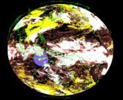
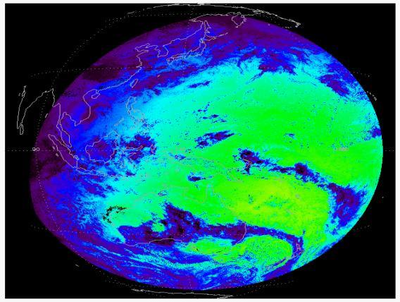
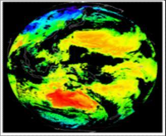
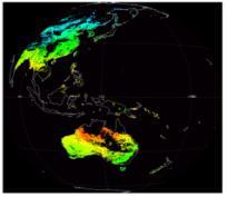
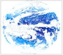
7 COMS First Images Visible Image ( :15 KST) IR Images ( :14 KST)

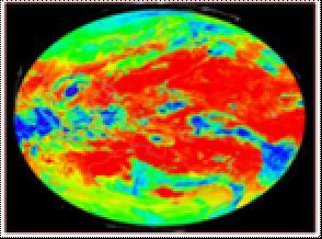
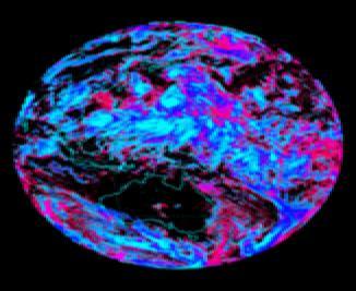
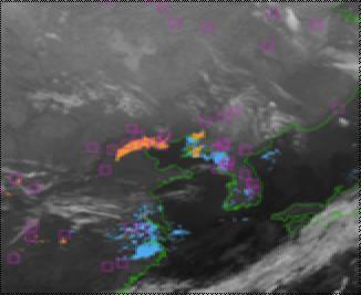
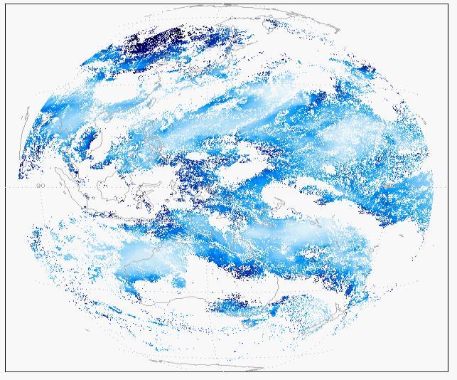
8 COMS Special typhoon Images

9 Operation of COMS KMA release COMS MI Images started on April 1,


10 COMS MI Observation Schedule ENH FD Possible Scan Mode APNH LA LSH Full Disk every 3 hours ENH every 15 min. East Asia every 15 min. Korean Peninsular 8 times an hour 10


11 COMS Meteorological Data Processing System CMDPS : 16 Level 2 baseline products Development : KMA(NIMR), 8 Universities 10 Professors Period : ~ NMSC Level 1B Image Data Generation Pre Processing Auxiliary data Data Processing Image Processing Validation Distribution Archive CMDPS Cloud Detection Cloudy confidently cloudy cloudy probably cloudy probably clear confident clear SSI AI/AOD OLR INS Clear AMV CLD Info FOG LST TPW CSR CTTH RI SST UTH 11


12 COMS Baseline Products Image Service Cloud Detection Atmospheric motion vector Land Surface Temperature Sea Surface Temperature Snow/Sea Ice Detection Tropospheric Precipitable Water Fog Cloud Top Temperature COMS Upper Tropospheric Humidity Cloud Analysis Clear Sky Radiation Aerosol Optical Depth Aerosol Index Outgoing Longwave Radiation Rainfall Intensity Insolation Validation 12


13 13 Ground Segment for COMS regional NMSC(KMA) KARI:Korea Aerospace Research Institute KORDI : Korea Ocean Research and development Institute ETRI : Electronics and Telecommunications Research Institute
 Night time: 3 ch (Shortwave IR, IR, WV) Pixel data range: 0 255(8 bit) Resolution : VIS 5km / IR 5km Mapping : Satellite View")
14 COMS xrit Image Data Detail (I) HRIT Daytime : 5 ch ( VIS, Shortwave IR, WV, IR1, IR2) Night time : 4 ch (Shortwave IR, WV, IR1, IR2) Pixel data range: (10 bit) Resolution : VIS 1km, IR 4km Mapping : Satellite View LRIT Daytime: 3 ch (VIS, IR, WV) Night time: 3 ch (Shortwave IR, IR, WV) Pixel data range: 0 255(8 bit) Resolution : VIS 5km / IR 5km Mapping : Satellite View 14

15 COMS xrit Image Data Detail (II) Encryption of HRIT/LRIT : HRIT/LRIT encryption function should be operator selectable Baseline for HRIT : Image data dissemination should be completed within 15 minutes from the end of observation Image data of all 5 channels will be disseminated in full resolution, for the area of FD and ENH Baseline for data service through Internet Continue current level of satellite data service Image/products for Area of Interest in image format Baseline data service for authorized users MI Level 1B format 15
 data Distribution of GOCI data with size of up to 3MB, with a frequency of 8 times a day can be")
16 COMS xrit Image Data Detail (III) Baseline for LRIT : (Continue) Auxiliary information Conversion table LRIT Dissemination schedule Encryption key information GOCI(Geostationary Ocean Color Imager) data Distribution of GOCI data with size of up to 3MB, with a frequency of 8 times a day can be available 16


17 Satellite Data Service Intranet Service System for Combined Meteorological Information Satellite Data Service System Web based Satellite Image Analysis System Service system for Disaster Prevention KMA Homepage Satellite Information Service System 17
18 Status of COMS follow on


19 Missions of COMS follow on Continuing the COMS Meteorological Mission ü Planning to be launched in 2017 Improving the Severe Weather Monitoring ü Higher frequency of observation ü Retrieving the atmospheric structure (pseudo sounding) Improving the support of the NWP model ü Efficient data assimilation system Intensifying the environment & climate monitoring ü Various surface information retrieval ü Air pollution monitoring ü Establishing long term observation data 19

, and the other for the Ocean and")
 COMS follow")
20 Development of COMS follow on A conceptual design for twin satellites is proposed in 2009 based on Korea National Plan for Space Development One for the Meteorological Imager follow on(2017), and the other for the Ocean and Atmospheric Trace Gas monitoring(2018) The program will be started in middle of 2011 COMS follow on (2A) COMS follow on (2B) 20
21 COMS follow on payload (I) Meteorological payload COMS COMS Follow on Channels 5 16 Spatial Resolution(km) 1/4(VIS/IR) 0.5,1/2(VIS/IR) Temporal Resolution(min) 25(Full Disk) 15(Full Disk) Level 2 Products 16 ~58 Data Rate(Mbps) 2.6 ~70 Life time(years) 7 10 Main Purpose of use Weather Forecasting + NWP + CM 21
22 COMS follow on payload (II) Sensor for space weather Mass/Power budgets are limited due to the size of satellite (using same size as COMS) Possible to on board : Particle detector, Magnetometer and so on HEPD : (m), 5 (kg) LEPD : (m), 5 (kg) Magnetometer : (m), 10 (kg), 3m(after boom deploy) On going preliminary study for Space weather payload (2011) 22


23 International Cooperation International Meeting / Cooperation International Meeting in Korea CGMS CGMS // GSICS GSICS // RARS RARS // WMO CM WMO CM ü ü ITWG, ITWG, IWWG, IWWG, IPWG IPWG WMO WMO RA RA Ⅱ Ⅱ Pilot Pilot Project Project APSDEU APSDEU Bilateral Bilateral Meeting Meeting GRWG/GDWG GRWG/GDWG 3.22~25, 3.22~25, // Daejeon Daejeon CGMS 37 CGMS ~30, 10.26~30, // Jeju Jeju ü NOAA, EUMETSAT, BOM, Japan NOAA, EUMETSAT, BOM, Japan Text inühere NASA/ NOAA Support Support of of developing developing country country in in E. E. Asia Asia ü ü COMS COMS receiving receiving system system EUMETSAT JMA Training International International Training Training over over Asia Asia ü ü 2008~ ~2010 WMO WMO Vlab Vlab Operation Operation of of CoE CoE
24 Thank you 고맙습니다
KOREA GEOSTATIONARY SATELLITE PROGRAM : COMMUNICATION, OCEAN, AND METEOROLOGICAL SATELLITE(COMS)
") KOREA GEOSTATIONARY SATELLITE PROGRAM : COMMUNICATION, OCEAN, AND METEOROLOGICAL SATELLITE(COMS) Mi-Lim Ou, Jae-Gwang-Won, Sung-Rae Chung, Hye-Sook Lee, and Ae-Sook Suh Korea Meteorological Administration
KOREA GEOSTATIONARY SATELLITE PROGRAM : COMMUNICATION, OCEAN, AND METEOROLOGICAL SATELLITE(COMS) Mi-Lim Ou, Jae-Gwang-Won, Sung-Rae Chung, Hye-Sook Lee, and Ae-Sook Suh Korea Meteorological Administration
Jun Park National Meteorological Satellite Center Korea Meteorological Administration
 KMA Implementation Plan for Satellite Climate products Jun Park National Meteorological Satellite Center Korea Meteorological Administration jun.park@kma.go.kr Outline 1. Introduction : Current & Future
MSG system over view
 MSG system over view 1 Introduction METEOSAT SECOND GENERATION Overview 2 MSG Missions and Services 3 The SEVIRI Instrument 4 The MSG Ground Segment 5 SAF Network 6 Conclusions METEOSAT SECOND GENERATION
FUTURE PLAN AND RECENT ACTIVITIES FOR THE JAPANESE FOLLOW-ON GEOSTATIONARY METEOROLOGICAL SATELLITE HIMAWARI-8/9
 FUTURE PLAN AND RECENT ACTIVITIES FOR THE JAPANESE FOLLOW-ON GEOSTATIONARY METEOROLOGICAL SATELLITE HIMAWARI-8/9 Toshiyuki Kurino Japan Meteorological Agency, 1-3-4 Otemachi Chiyodaku, Tokyo 100-8122,
STATUS OF JAPANESE METEOROLOGICAL SATELLITES AND RECENT ACTIVITIES OF MSC
 STATUS OF JAPANESE METEOROLOGICAL SATELLITES AND RECENT ACTIVITIES OF MSC Daisaku Uesawa Meteorological Satellite Center, Japan Meteorological Agency Abstract MTSAT-1R is the current operational Japanese
Benefits of the new-generation Himawari-8 geostationary satellite for the Asia-Pacific region. Toshihiko HASHIDA Japan Meteorological Agency (JMA)
") Benefits of the new-generation Himawari-8 geostationary satellite for the Asia-Pacific region Toshihiko HASHIDA Japan Meteorological Agency (JMA) Side Event Ensuring User Readiness to New-Generation Meteorological
Benefits of the new-generation Himawari-8 geostationary satellite for the Asia-Pacific region Toshihiko HASHIDA Japan Meteorological Agency (JMA) Side Event Ensuring User Readiness to New-Generation Meteorological
Preparation for Himawari 8
 Preparation for Himawari 8 Japan Meteorological Agency Meteorological Satellite Center Hidehiko MURATA ET SUP 8, WMO HQ, Geneva, 14 17 April 2014 1/18 Introduction Background The Japan Meteorological Agency
GEO New Mission and Synergy Joo-Hyung Ryu
 GEO New Mission and Synergy Joo-Hyung Ryu Korea Ocean Satellite Center Korea Institute Ocean Sciences & Technology GEMS GOCI-II GOCI Development : KARI & KIOST Cooperation Development Payload system -
Himawari 8/9 data distribution/dissemination plan
 Himawari 8/9 data distribution/dissemination plan Japan Meteorological Agency (JMA) Hidehiko MURATA Himawari is the name of this flower in Japanese ET SUP 8, WMO HQ, Geneva, 14 17 April 2014 1 Outline
RA II Pilot Project Newsletter
 Vol. 2 No. 2, May 2011 RA II Pilot Project Newsletter DEVELOPING SUPPORT FOR NATIONAL METEOROLOGICAL AND HYDROLOGICAL SERVICES IN SATELLITE DATA, PRODUCTS AND TRAINING Contents of this issue Page ² First
1. History and Current Status
 Contents 1. History and Current Status History and Mission Image acquisition and Dissemination Products 2. Future Plan Schedule Mission of Himawari 8/9 Development of Products Data Dissemination 0 1. History
Current status of GK-2A AMV algorithm in NMSC/KMA
 Current status of GK-2A AMV algorithm in NMSC/KMA 23 April 2018 Soo Min Oh, Byung-il Lee, Sung-Rae Chung, Seonkyun Baek NMSC/KMA 국가기상위성센터 National Meteorological Satellite Center Contents Status of COMS
VALIDATION OF INSAT-3D DERIVED RAINFALL. (Submitted by Suman Goyal, IMD) Summary and Purpose of Document
 Summary and Purpose of Document") WORLD METEOROLOGICAL ORGANIZATION COMMISSION FOR BASIC SYSTEMS OPEN PROGRAMME AREA GROUP ON INTEGRATED OBSERVING SYSTEMS INTER-PROGRAMME EXPERT TEAM ON SATELLITE UTILIZATION AND PRODUCTS SECOND SESSION
WORLD METEOROLOGICAL ORGANIZATION COMMISSION FOR BASIC SYSTEMS OPEN PROGRAMME AREA GROUP ON INTEGRATED OBSERVING SYSTEMS INTER-PROGRAMME EXPERT TEAM ON SATELLITE UTILIZATION AND PRODUCTS SECOND SESSION
Status and Plans of Next Generation Japanese Geostationary Meteorological Satellites Himawari 8/9
 Status and Plans of Next Generation Japanese Geostationary Meteorological Satellites Himawari 8/9 Masahiro Hayashi 1, Kotaro Bessho 1, and Tomoo Ohno 2 1: JMA/Meteorological Satellite Center (MSC) 2: JMA/Satellite
Status report on the. systems by KMA. Presented to CGMS-43 plenary session, agenda item [E.1]
![Status report on the. systems by KMA. Presented to CGMS-43 plenary session, agenda item [E.1]](/thumbs/89/97785525.jpg "Status report on the. systems by KMA. Presented to CGMS-43 plenary session, agenda item [E.1]") Status report on the current and future satellite systems by KMA Presented to CGMS-43 plenary session, agenda item [E.1] Current Geo-Satellites : COMS COMS(Communication, Ocean, and Meteorological Satellite)
Status report on the current and future satellite systems by KMA Presented to CGMS-43 plenary session, agenda item [E.1] Current Geo-Satellites : COMS COMS(Communication, Ocean, and Meteorological Satellite)
Current Status and Future Plan of KMA Satellite Program
 The 5th Asia-Oceania Meteorological Satellite Users Conference(2014. 11. 19) Current Status and Future Plan of KMA Satellite Program Sang Jin LYU National Meteorological Satellite Center Korea Meteorological
NEW CGMS BASELINE FOR THE SPACE-BASED GOS. (Submitted by the WMO Secretariat) Summary and Purpose of Document
 Summary and Purpose of Document") WORLD METEOROLOGICAL ORGANIZATION COMMISSION FOR BASIC SYSTEMS OPEN PROGRAMME AREA GROUP ON INTEGRATED OBSERVING SYSTEMS EXPERT TEAM ON SATELLITE SYSTEMS ET-SAT-7/Inf. 2 (12.III.2012) ITEM: 8.1 SEVENTH
WORLD METEOROLOGICAL ORGANIZATION COMMISSION FOR BASIC SYSTEMS OPEN PROGRAMME AREA GROUP ON INTEGRATED OBSERVING SYSTEMS EXPERT TEAM ON SATELLITE SYSTEMS ET-SAT-7/Inf. 2 (12.III.2012) ITEM: 8.1 SEVENTH
Preparation for FY-4A. (Submitted by Xiang Fang, CMA)
") WORLD METEOROLOGICAL ORGANIZATION COMMISSION FOR BASIC SYSTEMS OPEN PROGRAMME AREA GROUP ON INTEGRATED OBSERVING SYSTEMS EXPERT TEAM ON SATELLITE UTILIZATION AND PRODUCTS ET-SUP-8/Doc. 10.3 (2.IV.2014)
WORLD METEOROLOGICAL ORGANIZATION COMMISSION FOR BASIC SYSTEMS OPEN PROGRAMME AREA GROUP ON INTEGRATED OBSERVING SYSTEMS EXPERT TEAM ON SATELLITE UTILIZATION AND PRODUCTS ET-SUP-8/Doc. 10.3 (2.IV.2014)
A 2016 CEOS Chair Initiative. Non-meteorological Applications for Next Generation Geostationary Satellites
 A 2016 CEOS Chair Initiative Committee on Earth Observation Satellites Non-meteorological Applications for Next Generation Geostationary Satellites Co-chaired by EUMETSAT (Holmlund), CSIRO (Schroeder),
Status of Indian Satellite Meteorological Programme
 Status of Indian Satellite Meteorological Programme Pradeep K Thapliyal Space Applications Centre (SAC) Indian Space research Organisation (ISRO) Ahmedabad (INDIA) Email: pkthapliyal@sac.isro.gov.in International
Monitoring Sand and Dust Storms from Space
 Monitoring Sand and Dust Storms from Space for Expert Consultation on Disaster Information and Knowledge, Session 2 ICC 21 for ESCAP s RESAP and CDRR 5 9 12 October, 2017 Toshiyuki KURINO WMO Space Programme
Updates on Chinese Meteorological Satellite Programs
 6 th Asia/Oceania Meteorological Satellite Users Conference Updates on Chinese Meteorological Satellite Programs Caiying Wei Deputy director-general of NSMC National Satellite Meteorological Center (NSMC)
4.1 New Generation Satellite Data and Nowcasting Products: Himawari
 4.1 New Generation Satellite Data and Nowcasting Products: Himawari SCOPE-Nowcasting-EP 18-20 September 2017 Koji Yamashita kobo.yamashita@met.kishou.go.jp Meteorological Satellite Center (MSC) Japan Meteorological
Lecture 4b: Meteorological Satellites and Instruments. Acknowledgement: Dr. S. Kidder at Colorado State Univ.
 Lecture 4b: Meteorological Satellites and Instruments Acknowledgement: Dr. S. Kidder at Colorado State Univ. US Geostationary satellites - GOES (Geostationary Operational Environmental Satellites) US
EUMETSAT products and services for monitoring storms - New missions, more data and more meteorological products
 EUMETSAT products and services for monitoring storms - New missions, more data and more meteorological products Jochen Grandell 1 EUM/RSP/VWG/17/921460 Outline Overview of EUMETSAT missions Current...and
The Status Report of FY-2F
 Seventh Session of the Expert Team on Satellite Utilization and Products The Status Report of FY-2F Presented by Xiang Fang National Satellite Meteorological Center (NSMC) China Meteorological Administration
The current status of FY-3D
 The current status of FY-3D Xiang Fang National Satellite Meteorological Center, China Meteorological Administration (NSMC/CMA) OUTLINE Overview Key instruments onboard FY-3D Products and data service
METEOSAT THIRD GENERATION
 METEOSAT THIRD GENERATION FACTS AND FIGURES MONITORING WEATHER AND CLIMATE FROM SPACE A HIGHLY INNOVATIVE GEOSTATIONARY SATELLITE SYSTEM FOR EUROPE AND AFRICA The Meteosat Third Generation (MTG) system
McIDAS support of Suomi-NPP /JPSS and GOES-R L2
 McIDAS support of Suomi-NPP /JPSS and GOES-R L2 William Straka III 1 Tommy Jasmin 1, Bob Carp 1 1 Cooperative Institute for Meteorological Satellite Studies, Space Science and Engineering Center, University
Satellite P rogram s & Applications of K M A : Current & Future
 Satellite P rogram s & Applications of K M A : Current & Future Sang Jin LYU National Meteorological Satellite Center Korea Meteorological Administration sjlyu@korea.kr 1 2 Observation Schedule of COMS
JMA s atmospheric motion vectors
 Prepared by JMA Agenda Item: WG II/6 Discussed in WG II JMA s atmospheric motion vectors This paper reports on the recent status of JMA's Atmospheric Motion Vectors (AMVs) from MTSAT-2 and MTSAT-1R, and
Update on SCOPE-Nowcasting Pilot Project Real Time Ocean Products Suman Goyal Scientist-E
 Update on SCOPE-Nowcasting Pilot Project Real Time Ocean Products Suman Goyal Scientist-E 19-22 Nov 2013 SCOPE-Nowcasting-1 Agenda Item 5 Pilot Projects Overview Users /Clients User requirements Product
Status report on the current and future satellite systems by CMA. Presented to CGMS46-CMA-WP-01, Plenary session, agenda item D.1
 Status report on the current and future satellite systems by CMA Presented to CGMS46-CMA-WP-01, Plenary session, agenda item D.1 Overview - Planning of CMA satellite systems FengYun Meteorological Satellites
Satellite observation of atmospheric dust
 Satellite observation of atmospheric dust Taichu Y. Tanaka Meteorological Research Institute, Japan Meteorological Agency 11 April 2017, SDS WAS: Dust observation and modeling @WMO, Geneva Dust observations
RA II Pilot Project Newsletter
 Vol. 1 No. 4, July 2010 RA II Pilot Project Newsletter DEVELOPING SUPPORT FOR NATIONAL METEOROLOGICAL AND HYDROLOGICAL SERVICES IN SATELLITE DATA, PRODUCTS AND TRAINING Contents of this issue Page 5 th
A New Era: Three-Dimensional Observation and Service with Fully High Resolutions on FY-4 Platform are Coming Next Year
 6 th Asia/Oceania Meteorological Satellite Users Conference A New Era: Three-Dimensional Observation and Service with Fully High Resolutions on FY-4 Platform are Coming Next Year Presented by Qiang Guo
CGMS Baseline In response to CGMS action/recommendation A45.01 HLPP reference: 1.1.8
 Prepared by WGIII Agenda Item: 7.1 Discussed in WGIII CGMS Baseline In response to CGMS action/recommendation A45.01 HLPP reference: 1.1.8 In CGMS-45, Working Group III agreed to hold a review of the CGMS
Operational Uses of Bands on the GOES-R Advanced Baseline Imager (ABI) Presented by: Kaba Bah
 Presented by: Kaba Bah") Operational Uses of Bands on the GOES-R Advanced Baseline Imager (ABI) Presented by: Kaba Bah Topics: Introduction to GOES-R & ABI ABI individual bands Use of band differences ABI derived products Conclusions
Operational Uses of Bands on the GOES-R Advanced Baseline Imager (ABI) Presented by: Kaba Bah Topics: Introduction to GOES-R & ABI ABI individual bands Use of band differences ABI derived products Conclusions
GENERATION OF HIMAWARI-8 AMVs USING THE FUTURE MTG AMV PROCESSOR
 GENERATION OF HIMAWARI-8 AMVs USING THE FUTURE MTG AMV PROCESSOR Manuel Carranza 1, Régis Borde 2, Masahiro Hayashi 3 1 GMV Aerospace and Defence S.A. at EUMETSAT, Eumetsat Allee 1, D-64295 Darmstadt,
The In-Orbit Commissioning of MSG-1
 Earth Observation The In-Orbit Commissioning of MSG-1 MSG Project Team, Earth Observation Projects Department, ESA Directorate of Earth Observation, ESTEC, Noordwijk, The Netherlands 80 esa bulletin 114
Sand and Dust Monitoring in RA II
 Sand and Dust Monitoring in RA II Xiang Fang National Satellite Meteorological Center,CMA Outline Dust products in RA II Validation of multi-satellite products Action Proposed Dust products in RA II Operational
Himawari 8: Experiences and Lessons Learned. Daisaku Uesawa Meteorological Satellite Center (MSC) Japan Meteorological Agency (JMA)
 Japan Meteorological Agency (JMA)") Himawari 8: Experiences and Lessons Learned Daisaku Uesawa Meteorological Satellite Center (MSC) Japan Meteorological Agency (JMA) IPET SUP 2, GENEVA, SWITZERLAND, 23 26 FEBRUARY 2016 1 Himawari-8 operation
Himawari 8: Experiences and Lessons Learned Daisaku Uesawa Meteorological Satellite Center (MSC) Japan Meteorological Agency (JMA) IPET SUP 2, GENEVA, SWITZERLAND, 23 26 FEBRUARY 2016 1 Himawari-8 operation
APPENDIX 2 OVERVIEW OF THE GLOBAL PRECIPITATION MEASUREMENT (GPM) AND THE TROPICAL RAINFALL MEASURING MISSION (TRMM) 2-1
 AND THE TROPICAL RAINFALL MEASURING MISSION (TRMM) 2-1") APPENDIX 2 OVERVIEW OF THE GLOBAL PRECIPITATION MEASUREMENT (GPM) AND THE TROPICAL RAINFALL MEASURING MISSION (TRMM) 2-1 1. Introduction Precipitation is one of most important environmental parameters.
APPENDIX 2 OVERVIEW OF THE GLOBAL PRECIPITATION MEASUREMENT (GPM) AND THE TROPICAL RAINFALL MEASURING MISSION (TRMM) 2-1 1. Introduction Precipitation is one of most important environmental parameters.
The current status of FY-3D. (Submitted by Xiang Fang, CMA) Summary and Purpose of Document
 Summary and Purpose of Document") WORLD METEOROLOGICAL ORGANIZATION COMMISSION FOR BASIC SYSTEMS OPEN PROGRAMME AREA GROUP ON INTEGRATED OBSERVING SYSTEMS INTER-PROGRAMME EXPERT TEAM ON SATELLITE UTILIZATION AND PRODUCTS FOURTH SESSION
WORLD METEOROLOGICAL ORGANIZATION COMMISSION FOR BASIC SYSTEMS OPEN PROGRAMME AREA GROUP ON INTEGRATED OBSERVING SYSTEMS INTER-PROGRAMME EXPERT TEAM ON SATELLITE UTILIZATION AND PRODUCTS FOURTH SESSION
Latest status and developments at IMD since CGMS-45
 Latest status and developments at IMD since CGMS-45 CGMS-46, Plenary session, agenda item IMD-ISRO-WP-01 Presenter: S K Peshin Report Prepared By: S K Peshin, Virendra Singh, A.K.Mitra Overview - Planning
Interpretation of Polar-orbiting Satellite Observations. Atmospheric Instrumentation
 Interpretation of Polar-orbiting Satellite Observations Outline Polar-Orbiting Observations: Review of Polar-Orbiting Satellite Systems Overview of Currently Active Satellites / Sensors Overview of Sensor
EUMETSAT PLANS. Dr. K. Dieter Klaes EUMETSAT Am Kavalleriesand 31 D Darmstadt Germany
 EUMETSAT PLANS Dr. K. Dieter Klaes EUMETSAT Am Kavalleriesand 31 D-64295 Darmstadt Germany Page 1 EUMETSAT SATELLITE PROGRAMMES 96 97 98 99 00 01 02 03 04 05 06 07 08 09 10 11 12 13 14 15 16 17 18 METEOSAT
Overview on GK-2A Data and Products
 SCOPE-Nowcasting EP-1 Overview on GK-2A Data and Products Jae-Dong Jang NMSC Geo-KOMPSAT-2A, AMI Sector Satellite in Orbit Operator Location Launch date Environmental payload and status GEO-KOMPSAT-2A
Country Report - Singapore
 Country Report - Singapore The 5th Meeting of the Coordinating Group Vladivostok city, Russky Island, Russia Far Eastern Federal University of the RA II WIGOS Satellite Project 21 October 2017 Outline
CMA Consideration on early-morning orbit satellite
 CMA Consideration on early-morning orbit satellite National Satellite Meteorological Center,CMA Yang Jun CGMS 40 in Lugano, 5-9 Nov., 2012 Outline Background Gap analysis on the sounding data coverage
CLAVR-x is the Clouds from AVHRR Extended Processing System. Responsible for AVHRR cloud products and other products at various times.
 CLAVR-x in CSPP Andrew Heidinger, NOAA/NESDIS/STAR, Madison WI Nick Bearson, SSEC, Madison, WI Denis Botambekov, CIMSS, Madison, WI Andi Walther, CIMSS, Madison, WI William Straka III, CIMSS, Madison,
Introduction of JMA VLab Support Site on RGB Composite Imagery and tentative RGBs
 The Sixth Asia/Oceania Meteorological Satellite Users' Conference 9 13 November 2015, Tokyo/Japan J M A Introduction of JMA VLab Support Site on RGB Composite Imagery and tentative RGBs Akihiro SHIMIZU
Preparing for NOAA s Next Generation GOES-R & JPSS
 Preparing for NOAA s Next Generation GOES-R & JPSS Mark Paese Deputy Assistant Administrator NOAA Environmental Satellite & Information Service (NESDIS) WMO Cg-17: Ensuring User Readiness for New Generation
file://c:\documents and Settings\Best J\Local Settings\Temp\XPgrpwise\4B950198WM...
 file://c:\documents and Settings\Best J\Local Settings\Temp\XPgrpwise\4B950198WM... Page 1 of 1 3/9/2010 Jennifer Best - Updates to WMO Publication No.9 Volume C2 From: To:
Brief introduction to. National Satellite Meteorological Center, CMA. Jinsong Wang Deputy Director-General NSMC/CMA
 Brief introduction to National Satellite Meteorological Center, CMA Jinsong Wang Deputy Director-General NSMC/CMA Rio de Janerio, Oct. 12-15, 10 Beijing Guangzhou Urumuqi Jiamusi 2 NSMC DPC@NSMC KIRUNA
EUMETSAT SAF NETWORK. Lothar Schüller, EUMETSAT SAF Network Manager
 1 EUMETSAT SAF NETWORK Lothar Schüller, EUMETSAT SAF Network Manager EUMETSAT ground segment overview METEOSAT JASON-2 INITIAL JOINT POLAR SYSTEM METOP NOAA SATELLITES CONTROL AND DATA ACQUISITION FLIGHT
Icing detection from geostationary satellite data over Korea and Japan using machine learning approaches
 Icing detection from geostationary satellite data over Korea and Japan using machine learning approaches Seongmun Sim 1 Seonghyeon Ha 1 Junghee Lee 1 Jungho Im1 1 School of Urban and Environmental Engineering,
DRARS Coordination Meeting Contribution from IMD
 DRARS Coordination Meeting Contribution from IMD Dr. Ashim Kumar Mitra Ministry of Earth Sciences India Meteorological Department New Delhi-INDIA 11-13 March 2015 The Processing System of NOAA/METOP/MODIS
Instrumentation planned for MetOp-SG
 Instrumentation planned for MetOp-SG Bill Bell Satellite Radiance Assimilation Group Met Office Crown copyright Met Office Outline Background - the MetOp-SG programme The MetOp-SG instruments Summary Acknowledgements:
Back to basics: From Sputnik to Envisat, and beyond: The use of satellite measurements in weather forecasting and research: Part 1 A history
 Back to basics: From Sputnik to Envisat, and beyond: The use of satellite measurements in weather forecasting and research: Part 1 A history Roger Brugge 1 and Matthew Stuttard 2 1 NERC Data Assimilation
Radiative Transfer Model based Bias Correction in INSAT-3D/3DR Thermal Observations to Improve Sea Surface Temperature Retrieval
 Radiative Transfer Model based Bias Correction in INSAT-3D/3DR Thermal Observations to Improve Sea Surface Temperature Retrieval Rishi K Gangwar, Buddhi P Jangid, and Pradeep K Thapliyal Space Applications
RGB Experts and Developers Workshop - Introduction Tokyo, Japan 7-9 Nov 2017
 RGB Experts and Developers Workshop - Introduction Tokyo, Japan 7-9 Nov 2017 Workshop Objectives Review of existing RGB standards Reconfirm and extend existing standards (new multi-spectral imagers) Stimulate
EPS-SG Candidate Observation Missions
 EPS-SG Candidate Observation Missions 3 rd Post-EPS User Consultation Workshop Peter Schlüssel Slide: 1 EPS-SG benefits to activities of NMSs Main Payload High-Resolution Infrared Sounding Microwave Sounding
WMO OSCAR. Observing Systems Capability Analysis and Review Tool A building block of Rolling Requirements Review
 WMO OSCAR Observing Systems Capability Analysis and Review Tool A building block of Rolling Requirements Review Quantitative user-defined requirements for observation of physical variables in application
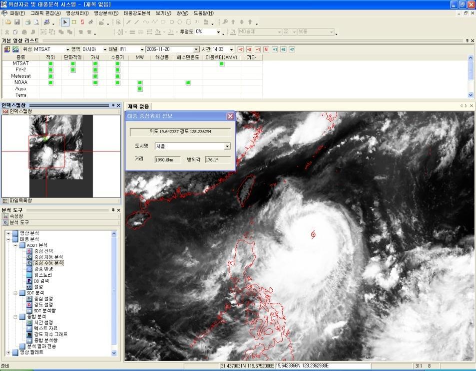
Current Status of COMS AMV in NMSC/KMA
 Current Status of COMS AMV in NMSC/KMA Eunha Sohn, Sung-Rae Chung, Jong-Seo Park Satellite Analysis Division, NMSC/KMA soneh0431@korea.kr COMS AMV of KMA/NMSC has been produced hourly since April 1, 2011.
Follow-up to WMO 2012 Survey on the Use of Satellite Data: Feedback by RA I Members
 WMO Follow-up to WMO 2012 Survey on the Use of Satellite Data: Feedback by RA I Members Gillie Cheelo-Intern WMO Space Programme World Meteorological Organization (WMO) WMO; Observation and Information
IMPACTS OF SPATIAL OBSERVATION ERROR CORRELATION IN ATMOSPHERIC MOTION VECTORS ON DATA ASSIMILATION
 Proceedings for the 13 th International Winds Workshop 27 June - 1 July 2016, Monterey, California, USA IMPACTS OF SPATIAL OBSERVATION ERROR CORRELATION IN ATMOSPHERIC MOTION VECTORS ON DATA ASSIMILATION
Introduction to Himawari-8
 Introduction to Himawari-8 Training on meteorological satellite data usage Kotaro BESSHO Meteorological Satellite Center (MSC) Japan Meteorological Agency (JMA) The Sixth Asia/Oceania Meteorological Satellite
Advanced Geostationary Observations for the OzEWEX Community. Leon Majewski Bureau of Meteorology
 Advanced Geostationary Observations for the OzEWEX Community Leon Majewski Bureau of Meteorology Overview Geostationary satellite missions & sensors Meteorological applications Access for OzEWEX researchers
Recent Improvement of Integrated Observation Systems in JMA
 Recent Improvement of Integrated Observation Systems in JMA Mr Osamu Suzuki and Mr Yoshihiko Tahara Japan Meteorological Agency 1-3-4 Otemachi, Chiyoda-ku, Tokyo 100-8122, Japan Tel: +81-3-3212-8341, Fax:
COORDINATION GROUP FOR METEOROLOGICAL SATELLITES AND GOFC-GOLD
 Coordination Group for Meteorological Satellites - CGMS COORDINATION GROUP FOR METEOROLOGICAL SATELLITES AND GOFC-GOLD Mitch Goldberg, CGMS co-liaison to CGMS Working group 2 satellite data and products
JMA s ATMOSPHERIC MOTION VECTORS In response to Action 40.22
 5 July 2013 Prepared by JMA Agenda Item: II/6 Discussed in WG II JMA s ATMOSPHERIC MOTION VECTORS In response to Action 40.22 This paper reports on the recent status of JMA's AMVs from MTSAT-2 and MTSAT-1R,
EUMETSAT Training activities. Vesa Nietosvaara Mark Higgins
 EUMETSAT Training activities Vesa Nietosvaara Mark Higgins EUMETSAT Partnerships Europe: SAFs and regional networks EUMeTrain training recourses and tools Eumetcal coordination and infrastructure Africa:
Future GOES (XGOHI, GOES-13/O/P, GOES-R+)
") Future GOES (XGOHI, GOES-13/O/P, GOES-R+) Timothy J. Schmit NOAA/NESDIS/Satellite Applications and Research Advanced Satellite Products Branch (ASPB) Madison, WI And many others MUG Meeting October 16,
Future GOES (XGOHI, GOES-13/O/P, GOES-R+) Timothy J. Schmit NOAA/NESDIS/Satellite Applications and Research Advanced Satellite Products Branch (ASPB) Madison, WI And many others MUG Meeting October 16,
Usage of McIDAS V with GOES R AWG products
 McIDAS User Group Meeting, October 25-27, 2010, Madison, WI Usage of McIDAS V with GOES R AWG products William Straka III UW/CIMSS Madison, Wisconsin, USA With help from Tom Rink (CIMSS/), Tom Achtor (CIMSS/),
Joint Polar Satellite System. 3 rd Post-EPS User Consultation Workshop Mike Haas
 3 rd Post-EPS User Consultation Workshop Mike Haas Overview Introduction - Policy Drivers - Management System Description - Space Segment - Ground Segment Partnerships Status Benefits 2 Introduction (Policy
EUMETSAT SAF NETWORK. Lothar Schüller, EUMETSAT SAF Network Manager
 1 EUMETSAT SAF NETWORK Lothar Schüller, EUMETSAT SAF Network Manager EUMETSAT ground segment overview METEOSAT JASON-2 INITIAL JOINT POLAR SYSTEM METOP NOAA SATELLITES CONTROL AND DATA ACQUISITION FLIGHT
Introduction of the in-orbit test and its performance for the first meteorological imager of the Communication, Ocean, and Meteorological Satellite
 Atmos. Meas. Tech., 7, 2471 2485, 2014 doi:10.5194/amt-7-2471-2014 Author(s) 2014. CC Attribution 3.0 License. Introduction of the in-orbit test and its performance for the first meteorological imager
Meteosat Third Generation. The Future European Geostationary Meteorological Satellite
 Meteosat Third Generation The Future European Geostationary Meteorological Satellite Meteosat Third Generation Jean-Loup Bézy, Donny Aminou & Paolo Bensi Future Programmes Department, ESA Directorate of
Polar winds from highly elliptical orbiting satellites: a new perspective
 Polar winds from highly elliptical orbiting satellites: a new perspective 10 th International Winds Workshop Tokyo, Japan, Feb -6, 010 L. Garand 1, N. Wagneur 1, R. Sarrazin 1, D. Santek, J. Key 1 Environment
EUMETSAT Activities Related to Climate
 EUMETSAT Activities Related to Climate Jörg Schulz joerg.schulz@eumetsat.int Slide: 1 What we do USER REQUIREMENTS European National Meteorological Services Operating Agency! European Space Industry Private
INDIAN OCEAN DATA COVERAGE (IODC) - CGMS ROADMAP
 - CGMS ROADMAP") Prepared by EUMETSAT Agenda Item: 2.3 WGIII/2.3 and Plenary G.4.2 Discussed in WGIII and Plenary INDIAN OCEAN DATA COVERAGE (IODC) - CGMS ROADMAP In response to CGMS actions/recommendations: EUM WGIII/2.2
Prepared by EUMETSAT Agenda Item: 2.3 WGIII/2.3 and Plenary G.4.2 Discussed in WGIII and Plenary INDIAN OCEAN DATA COVERAGE (IODC) - CGMS ROADMAP In response to CGMS actions/recommendations: EUM WGIII/2.2
Once a specific data set is selected, NEO will list related data sets in the panel titled Matching Datasets, which is to the right of the image.
 NASA Earth Observations (NEO): A Brief Introduction NEO is a data visualization tool that allows users to explore a wealth of environmental data collected by NASA satellites. The satellites use an array
CGMS Baseline. Sustained contributions to the Global Observing System. Endorsed by CGMS-46 in Bengaluru, June 2018
 CGMS Baseline Sustained contributions to the Global Observing System Best Practices for Achieving User Readiness for New Meteorological Satellites Endorsed by CGMS-46 in Bengaluru, June 2018 CGMS/DOC/18/1028862,
How to display RGB imagery by SATAID
 How to display RGB imagery by SATAID Akihiro SHIMIZU Meteorological Satellite Center (MSC), Japan Meteorological Agency (JMA) Ver. 2015110500 RGB imagery on SATAID SATAID software has a function of overlapping
ATMOS 5140 Lecture 1 Chapter 1
 ATMOS 5140 Lecture 1 Chapter 1 Atmospheric Radiation Relevance for Weather and Climate Solar Radiation Thermal Infrared Radiation Global Heat Engine Components of the Earth s Energy Budget Relevance for
Next generation of EUMETSAT microwave imagers and sounders: new opportunities for cloud and precipitation retrieval
 Next generation of EUMETSAT microwave imagers and sounders: new opportunities for cloud and precipitation retrieval Christophe Accadia, Sabatino Di Michele, Vinia Mattioli, Jörg Ackermann, Sreerekha Thonipparambil,
EUMETSAT STATUS AND PLANS
 1 EUM/TSS/VWG/15/826793 07/10/2015 EUMETSAT STATUS AND PLANS François Montagner, Marine Applications Manager, EUMETSAT WMO Polar Space Task Group 5 5-7 October 2015, DLR, Oberpfaffenhofen PSTG Strategic
ABB Remote Sensing Atmospheric Emitted Radiance Interferometer AERI system overview. Applications
 The ABB Atmospheric Emitted Radiance Interferometer AERI provides thermodynamic profiling, trace gas detection, atmospheric cloud aerosol study, air quality monitoring, and more. AERI high level overview
Meteorological Service of Canada Perspectives. WMO Coordination Group on Satellite Data Requirements for RAIII/IV
 Meteorological Service of Canada Perspectives presented to the WMO Coordination Group on Satellite Data Requirements for RAIII/IV David Bradley Meteorological Service of Canada Environment Canada April
Introducing Atmospheric Motion Vectors Derived from the GOES-16 Advanced Baseline Imager (ABI)
") Introducing Atmospheric Motion Vectors Derived from the GOES-16 Advanced Baseline Imager (ABI) Jaime Daniels NOAA/NESDIS, Center for Satellite Applications and Research Wayne Bresky, Andrew Bailey, Americo
Introducing Atmospheric Motion Vectors Derived from the GOES-16 Advanced Baseline Imager (ABI) Jaime Daniels NOAA/NESDIS, Center for Satellite Applications and Research Wayne Bresky, Andrew Bailey, Americo
Long-term Water Cycle Observation by the Advanced Microwave Scanning Radiometer (AMSR) Series: AMSR-E, AMSR2 and Follow-on
 Series: AMSR-E, AMSR2 and Follow-on") Long-term Water Cycle Observation by the Advanced Microwave Scanning Radiometer (AMSR) Series: AMSR-E, AMSR2 and Follow-on M. Kachi 1), H. Fujii 1), T. Kubota 1), T. Maeda 1), N. Ono 1), M. Kasahara 1),
Long-term Water Cycle Observation by the Advanced Microwave Scanning Radiometer (AMSR) Series: AMSR-E, AMSR2 and Follow-on M. Kachi 1), H. Fujii 1), T. Kubota 1), T. Maeda 1), N. Ono 1), M. Kasahara 1),
WMO Coordination Group on Satellite Data Requirements for Region III and IV Sept 5-8, 2016 Willemstad, Curaçao
 WMO Coordination Group on Satellite Data Requirements for Region III and IV Sept 5-8, 2016 Willemstad, Curaçao 1. Current Satellite Reception 2. Preparation for Next-Gen GOES-R JPSS 3. Satellite Data Applications
Atmospheric circulation analysis for seasonal forecasting
 Training Seminar on Application of Seasonal Forecast GPV Data to Seasonal Forecast Products 18 21 January 2011 Tokyo, Japan Atmospheric circulation analysis for seasonal forecasting Shotaro Tanaka Climate
WMO SPACE PROGRAMME ONLINE RESOURCES (Product Access Guide, Data Access Page, Tools Page) (Submitted by the Secretariat)
 (Submitted by the Secretariat)") WORLD METEOROLOGICAL ORGANIZATION COMMISSION FOR BASIC SYSTEMS OPEN PROGRAMME AREA GROUP ON INTEGRATED OBSERVING SYSTEMS INTER-PROGRAMME EXPERT TEAM ON SATELLITE UTILIZATION AND PRODUCTS SECOND SESSION
WORLD METEOROLOGICAL ORGANIZATION COMMISSION FOR BASIC SYSTEMS OPEN PROGRAMME AREA GROUP ON INTEGRATED OBSERVING SYSTEMS INTER-PROGRAMME EXPERT TEAM ON SATELLITE UTILIZATION AND PRODUCTS SECOND SESSION
Status of the Sentinel-5 Precursor Presented by C. Zehner S5p, S4, and S5 Missions Manager - ESA
 Status of the Sentinel-5 Precursor Presented by C. Zehner S5p, S4, and S5 Missions Manager - ESA European response to global needs: to manage the environment, to mitigate the effects of climate change
Contribution to global Earth observation from satellites
 Contribution to global Earth observation from satellites - JAXA s Earth Observation strategy - April 16, 2008 Makoto Kajii Japan Aerospace Exploration Agency Earth Observation Summits and GEOSS 1 st EO
Overview of Himawari-8/9
 Overview of Himawari-8/9 Toshiyuki SAKURAI Meteorological Satellite Center (MSC) Japan Meteorological Agency (JMA) EUMeTrain Event Week on MTG-I Satellite 2016 Session2 - Himawari-8 and Data Applications
Planning for next generation geostationary satellites (GK-2A) of Korea Meteorological Administration (KMA)
 of Korea Meteorological Administration (KMA)") Planning for next generation geostationary satellites (GK-2A) of Korea Meteorological Administration (KMA) Yunbok Lee & Geun-Hyeok Ryu 1 NMSC Goal To operate timely COMS, to gather reliable satellite data
Planning for next generation geostationary satellites (GK-2A) of Korea Meteorological Administration (KMA) Yunbok Lee & Geun-Hyeok Ryu 1 NMSC Goal To operate timely COMS, to gather reliable satellite data
Atmospheric Motion Vectors: Product Guide
 Atmospheric Motion Vectors: Product Guide Doc.No. Issue : : EUM/TSS/MAN/14/786435 v1a EUMETSAT Eumetsat-Allee 1, D-64295 Darmstadt, Germany Tel: +49 6151 807-7 Fax: +49 6151 807 555 Date : 9 April 2015