Status of Indian Satellite Meteorological Programme
|
|
|
- Kimberly Nelson
- 5 years ago
- Views:
Transcription
1 Status of Indian Satellite Meteorological Programme Pradeep K Thapliyal Space Applications Centre (SAC) Indian Space research Organisation (ISRO) Ahmedabad (INDIA) pkthapliyal@sac.isro.gov.in International TOVS Study Conference (ITSC-17), Monterey, CA (USA) April 2010


 Applications with Users Operational R & D ( National")
2 Indian Meteorological Satellite Missions Payload and Satellite: Design & Fabrication Geostationary : Optical Polar Orbiting: Thrust on Microwave ( Passive/Active) Launch : Polar : Operational Geostationary : Operational Signal and Data Processing, Retrievals, Validation Data Archival and Dissemination Meteorological & Oceanographic Satellite Data Archival Center (MOSDAC) PSLV Calibration & Validation (CALVAL) Applications with Users Operational R & D ( National Institutions and Academia) GSLV
3 Indian Missions for Weather & Climate Studies : Current & Future G E O Kalpana VHRR CMV, OLR, UTH,Rain INSAT-3A (2003) CMV, OLR, UTH, Rain, Aerosol VHRR, CCD INSAT-3D (2010) 6-Ch VHRR 19-Ch Sounder SST, CMV, OLR, UTH, Rain, T-q Profile, O 3 ƒinsat-3d R ƒgeo-hr ( ~2012) ƒfollow-up (~2015) L E O OCEANSAT 1/2 (1999/2009) Vector Winds, Aerosol, T&h Profile MSMR, OCM, Scatterometer ROSA (GPS) SARAL (2011) Altimeter SSH, Waves, Winds MEGHA-TROPIQUES (2011) MW Imager, WV Sounder, ScaRaB ROSA SS Wind, TWV, Rainfall T, h Profile, Radiation Budget
4 INSAT-3A & Kalpana-1 Location Payload : INSAT 3A : 93.5ºE Kalpana-1 : 74ºE : (i) VHRR & CCD camera in INSAT 3A (ii) VHRR in Kalpana-1 VHRR Bands (µm) Visible : Water vapour : Thermal Infra Red : Resolution (km) : 2 X 2 for Visible 8 X 8 for TIR and WV CCD Camera Bands (µm) Visible : Near Infra Red : Short Wave Infra Red : Resolution (km) : 1 X 1 for all bands

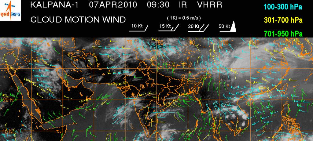

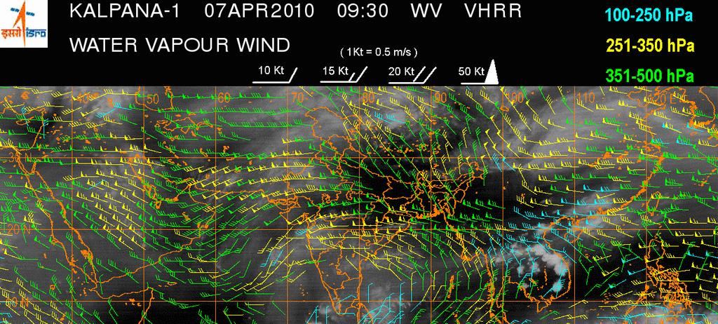
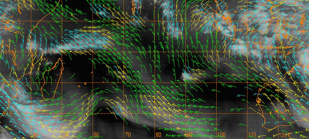
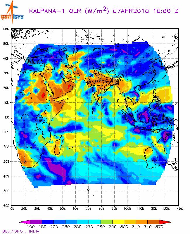
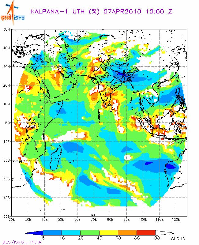

5 Kalpana-1 Products (IMDPS)
6 INSAT - 3D 6 Channel IMAGER 19 Channel SOUNDER Spectral Bands (µm) Visible : Short Wave IR : Mid Wave IR : Water Vapour : Thermal IR 1 : Thermal IR 2 : Resolution : 1 km for VIS, SWIR 4 km for MIR, TIR 8 km for WV Spectral Bands (µm) Short Wave IR : Six bands Mid Wave IR : Five Bands Long Wave IR Bands Visible : Seven : One Band Resolution (km) : 10 X 10 for all bands No of simultaneous : Four sounding per band
7 Oceansat -II Instruments: Scatterometer Ku band ( GHz) Ocean Colour Monitor (8 bands µm) Radio Occultation ROSA Launched - 23 September 2009 Applications: Sea State Forecast: Waves, Circulation and MLD Monsoon and Cyclone Forecast Antarctic Sea Ice Fisheries and Primary productivity estimation Detection and monitoring of Phytoplankton blooms Sediment dynamics

8 For studying water cycle and energy exchanges in the tropical belt Low inclination (20º) for frequent simultaneous observations of tropics Water vapour Clouds Cloud condensed water Precipitation evaporation Megha Tropiques SAPHIR SCARAB MADRAS ROSA 183 GHz WV Sounder Six atmospheric layers upto 12 km height 10 km Horizontal Resolution Outgoing fluxes at TOA 40 km Horizontal Resolution Precipitation and cloud properties 89 &157 GHz : ice particles in cloud tops 18 & 37 GHz: cloud liquid water and precipitation 23 GHz : Integrated water vapour T & q profile Contributing to GPM and GEWEX
 radar altimeter ¾ A dual-frequency MW radiometer (23.")
9 SARAL-AltiKa AltiKa (ISRO-CNES) AltiKa Mission: Global altimetry system for the precise and accurate observations of ocean topography, circulation and sea surface monitoring launch Date: 2011 AltiKa Payload : ¾ A Ka-band (35.75 GHz, BW 500 MHz) radar altimeter ¾ A dual-frequency MW radiometer (23.8 and 37 GHz), for tropospheric range correction ¾ DORIS: For achieving adequate orbitography performances ¾ LRA: For Orbitography and system calibration AltiKa/SARAL central objective : Ocean meso-scale variability: Sea state Monitoring & Now Casting Data assimilation: Sea state forecasting Coastal altimetry: Bathymetry, coastal upwelling, Circulations etc. Satellite Description : Sun-synchronous, polar orbiting inclination: Deg. Altitude: ~800 km, Repeat cycle: 35 days
10 Future Geostationary Satellites INSAT 3D Repeat (~ 2012) Follow-up of INSAT-3D (~2015) Geo HR ( ~2012) [name yet to be frozen] Visible 50 m 3 Channel IR 1.5 Km Visible and SWIR Hyper-spectral 500 m channels in VIS channels in SWIR - For general remote sensing, can also be used for meteorological purpose Microwave Temperature Sounder (Definition stage)
Indian Earth Observation Programme
 Indian Earth Observation Programme Dr. Jai Singh Parihar Dy. Director Remote Sensing Applications Area (RESA) Space Applications Centre (ISRO) Ahmedabad 380 015 India jsparihar@sac.isro.gov.in Presentation
ISRO Report on the Status of Current and future satellites. Presented to CGMS-44 WP-01 Plenary Session
 ISRO Report on the Status of Current and future satellites Presented to CGMS-44 WP-01 Plenary Session CGMS-44-ISRO 05-10 June 2016 Indian Satellite System for weather parameters Satellite Oceansat-1/ MSMR
Radiative Transfer Model based Bias Correction in INSAT-3D/3DR Thermal Observations to Improve Sea Surface Temperature Retrieval
 Radiative Transfer Model based Bias Correction in INSAT-3D/3DR Thermal Observations to Improve Sea Surface Temperature Retrieval Rishi K Gangwar, Buddhi P Jangid, and Pradeep K Thapliyal Space Applications
Megha-Tropiques Presentation by Indian Delegation at the 55th Session of UNCOPUOS Vienna 12 June 2012
 Megha-Tropiques Presentation by Indian Delegation at the 55 th Session of UNCOPUOS Vienna 12 June 2012 Megha-Tropiques Mission Indo-French Joint Satellite for studying tropical atmosphere Megha in Sanskrit
Update on SCOPE-Nowcasting Pilot Project Real Time Ocean Products Suman Goyal Scientist-E
 Update on SCOPE-Nowcasting Pilot Project Real Time Ocean Products Suman Goyal Scientist-E 19-22 Nov 2013 SCOPE-Nowcasting-1 Agenda Item 5 Pilot Projects Overview Users /Clients User requirements Product
RETRIEVAL AND APPLICATIONS OF ATMOSPHERIC MOTION VECTORS USING INSAT-3D/3DR DATA : ISRO STATUS
 RETRIEVAL AND APPLICATIONS OF ATMOSPHERIC MOTION VECTORS USING INSAT-3D/3DR DATA : ISRO STATUS Sanjib K Deb, D K Sankhala, C M Kishtawal Atmospheric and Oceanic Sciences Group Space Applications Centre
Atmospheric Motion Vectors from Kalpana-1: An ISRO status
 Atmospheric Motion Vectors from Kalpana-1: An ISRO status Sanjib Kr. Deb, Inderpreet Kaur, C. M. Kishtawal and P. K. Pal Atmospheric and Oceanic Sciences Group Space Applications Centre Indian Space Research
OCEAN COLOUR MONITOR ON-BOARD OCEANSAT-2
 OCEAN COLOUR MONITOR ON-BOARD OCEANSAT-2 Rangnath R Navalgund Space Applications Centre Indian Space Research Organisation Ahmedabad-380015, INDIA OCEANSAT-2 2 MISSION OCEANSAT-2 2 is a global mission
The Megha-Tropiques Mission
 The Megha-Tropiques Mission May 8,, 2010 0600Z courtesy www.satmos.meteo.fr Rémy Roca and the French MT science team Overview Indo-french mission realized by The Indian Space Research Organisation et the
Satellite Position Determination of LEO Spacecraft
 Satellite Position Determination of LEO Spacecraft S.C.Rathnakara ISRO Satellite Centre 5 th September, 2007 International Committee on Global Navigation Satellite Systems(ICG) Things to follow Brief background
VALIDATION OF INSAT-3D DERIVED RAINFALL. (Submitted by Suman Goyal, IMD) Summary and Purpose of Document
 Summary and Purpose of Document") WORLD METEOROLOGICAL ORGANIZATION COMMISSION FOR BASIC SYSTEMS OPEN PROGRAMME AREA GROUP ON INTEGRATED OBSERVING SYSTEMS INTER-PROGRAMME EXPERT TEAM ON SATELLITE UTILIZATION AND PRODUCTS SECOND SESSION
WORLD METEOROLOGICAL ORGANIZATION COMMISSION FOR BASIC SYSTEMS OPEN PROGRAMME AREA GROUP ON INTEGRATED OBSERVING SYSTEMS INTER-PROGRAMME EXPERT TEAM ON SATELLITE UTILIZATION AND PRODUCTS SECOND SESSION
Recent Indian Space Missions : Update Feb 2014
 Recent Indian Space Missions : Update Feb 2014 51 S&T Committee of UNCOPUOS 10-21 Feb, 2014, Vienna V. K. DADHWAL, ISRO, INDIA Mission Summary: 2013/2 2014/2 MISSION THEME (prev. Missions) REALIZED (Under
Earth Observation Satellite Program updates
 Earth Observation Satellite Program updates Presentation to ETSAT-7 meeting April 17-19, 2012, Geneva Prepared by: Indian Space Research Organisation Presented by Kashyap N. Mankad Space Applications Centre
HY-2A Satellite User s Guide
 National Satellite Ocean Application Service 2013-5-16 Document Change Record Revision Date Changed Pages/Paragraphs Edit Description i Contents 1 Introduction to HY-2 Satellite... 1 2 HY-2 satellite data
EUMETSAT STATUS AND PLANS
 1 EUM/TSS/VWG/15/826793 07/10/2015 EUMETSAT STATUS AND PLANS François Montagner, Marine Applications Manager, EUMETSAT WMO Polar Space Task Group 5 5-7 October 2015, DLR, Oberpfaffenhofen PSTG Strategic
Indian National (Weather) SATellites for Agrometeorological Applications
 SATellites for Agrometeorological Applications") Indian National (Weather) SATellites for Agrometeorological Applications Bimal K. Bhattacharya Agriculture-Terrestrial Biosphere- Hydrology Group Space Applications Centre (ISRO) Ahmedabad 380015, India
Indian National (Weather) SATellites for Agrometeorological Applications Bimal K. Bhattacharya Agriculture-Terrestrial Biosphere- Hydrology Group Space Applications Centre (ISRO) Ahmedabad 380015, India
APPENDIX 2 OVERVIEW OF THE GLOBAL PRECIPITATION MEASUREMENT (GPM) AND THE TROPICAL RAINFALL MEASURING MISSION (TRMM) 2-1
 AND THE TROPICAL RAINFALL MEASURING MISSION (TRMM) 2-1") APPENDIX 2 OVERVIEW OF THE GLOBAL PRECIPITATION MEASUREMENT (GPM) AND THE TROPICAL RAINFALL MEASURING MISSION (TRMM) 2-1 1. Introduction Precipitation is one of most important environmental parameters.
APPENDIX 2 OVERVIEW OF THE GLOBAL PRECIPITATION MEASUREMENT (GPM) AND THE TROPICAL RAINFALL MEASURING MISSION (TRMM) 2-1 1. Introduction Precipitation is one of most important environmental parameters.
REVISION OF THE STATEMENT OF GUIDANCE FOR GLOBAL NUMERICAL WEATHER PREDICTION. (Submitted by Dr. J. Eyre)
") WORLD METEOROLOGICAL ORGANIZATION Distr.: RESTRICTED CBS/OPAG-IOS (ODRRGOS-5)/Doc.5, Add.5 (11.VI.2002) COMMISSION FOR BASIC SYSTEMS OPEN PROGRAMME AREA GROUP ON INTEGRATED OBSERVING SYSTEMS ITEM: 4 EXPERT
WORLD METEOROLOGICAL ORGANIZATION Distr.: RESTRICTED CBS/OPAG-IOS (ODRRGOS-5)/Doc.5, Add.5 (11.VI.2002) COMMISSION FOR BASIC SYSTEMS OPEN PROGRAMME AREA GROUP ON INTEGRATED OBSERVING SYSTEMS ITEM: 4 EXPERT
Report on the Status of Current and future satellites by ISRO. Presented to CGMS-46 Plenary, agenda item D.7
 Report on the Status of Current and future satellites by ISRO Presented to CGMS-46 Plenary, agenda item D.7 Current Satellites LAND & WATER HIGH RESOLUTION OCEAN WEATHER; CLIMATE RESOURCESAT-2 LISS-3,
Radio Frequency Earth Science
 Radio Frequency Earth Science Overview for Committee On Radio Frequency (CORF) National Academy of Science National Research Council April 27, 2005 Bill.Watson@NASA.Gov Program Executive for Ground Networks
CGMS Baseline. Sustained contributions to the Global Observing System. Endorsed by CGMS-46 in Bengaluru, June 2018
 CGMS Baseline Sustained contributions to the Global Observing System Best Practices for Achieving User Readiness for New Meteorological Satellites Endorsed by CGMS-46 in Bengaluru, June 2018 CGMS/DOC/18/1028862,
Instrumentation planned for MetOp-SG
 Instrumentation planned for MetOp-SG Bill Bell Satellite Radiance Assimilation Group Met Office Crown copyright Met Office Outline Background - the MetOp-SG programme The MetOp-SG instruments Summary Acknowledgements:
NEW CGMS BASELINE FOR THE SPACE-BASED GOS. (Submitted by the WMO Secretariat) Summary and Purpose of Document
 Summary and Purpose of Document") WORLD METEOROLOGICAL ORGANIZATION COMMISSION FOR BASIC SYSTEMS OPEN PROGRAMME AREA GROUP ON INTEGRATED OBSERVING SYSTEMS EXPERT TEAM ON SATELLITE SYSTEMS ET-SAT-7/Inf. 2 (12.III.2012) ITEM: 8.1 SEVENTH
WORLD METEOROLOGICAL ORGANIZATION COMMISSION FOR BASIC SYSTEMS OPEN PROGRAMME AREA GROUP ON INTEGRATED OBSERVING SYSTEMS EXPERT TEAM ON SATELLITE SYSTEMS ET-SAT-7/Inf. 2 (12.III.2012) ITEM: 8.1 SEVENTH
Next generation of EUMETSAT microwave imagers and sounders: new opportunities for cloud and precipitation retrieval
 Next generation of EUMETSAT microwave imagers and sounders: new opportunities for cloud and precipitation retrieval Christophe Accadia, Sabatino Di Michele, Vinia Mattioli, Jörg Ackermann, Sreerekha Thonipparambil,
CNES Activity Report. Patrice Henry - CNES WGCV Plenary # 41 Tokyo Sept. 5-7, Working Group on Calibration and Validation
 Activity Report Patrice Henry - Tokyo Sept. 5-7, 2016 Working Group on Calibration and Validation SUMMARY Calibration Monitoring of in-flight Missions Preparation of future Missions Involvement in CEOS/WGCV
Interpretation of Polar-orbiting Satellite Observations. Atmospheric Instrumentation
 Interpretation of Polar-orbiting Satellite Observations Outline Polar-Orbiting Observations: Review of Polar-Orbiting Satellite Systems Overview of Currently Active Satellites / Sensors Overview of Sensor
CGMS Baseline In response to CGMS action/recommendation A45.01 HLPP reference: 1.1.8
 Prepared by WGIII Agenda Item: 7.1 Discussed in WGIII CGMS Baseline In response to CGMS action/recommendation A45.01 HLPP reference: 1.1.8 In CGMS-45, Working Group III agreed to hold a review of the CGMS
EUMETSAT PLANS. K. Dieter Klaes EUMETSAT Darmstadt, Germany
 EUMETSAT PLANS K. Dieter Klaes EUMETSAT Darmstadt, Germany 1. INTRODUCTION The European Organisation for the Exploitation of Meteorological Satellites (EUMETSAT), contributes to the World Weather Watch
PREDICTION AND MONITORING OF OCEANIC DISASTERS USING MICROWAVE REMOTE SENSING TECHNIQUES
 PREDICTION AND MONITORING OF OCEANIC DISASTERS USING MICROWAVE REMOTE SENSING TECHNIQUES O P N Calla International Centre for Radio Science, OM NIWAS A-23, Shastri Nagar, Jodhpur-342 003 Abstract The disasters
Ranganath R. Navalgund AND Raghavendra P. Singh
 REVIEWS The evolution of the earth observation system in India Ranganath R. Navalgund AND Raghavendra P. Singh Abstract The Indian Earth Observations Programme has been applications- driven and national
Impact of Megha-Tropique's SAPHIR humidity profiles in the Unified Model Analysis and Forecast System
 Impact of Megha-Tropique's SAPHIR humidity profiles in the Unified Model Analysis and Forecast System S. Indira Rani 1, Amy Doherty 2, Nigel Atkinson 2, William Bell 2, Stuart Newman 2, Richard Renshaw
Latest status and developments at IMD since CGMS-45
 Latest status and developments at IMD since CGMS-45 CGMS-46, Plenary session, agenda item IMD-ISRO-WP-01 Presenter: S K Peshin Report Prepared By: S K Peshin, Virendra Singh, A.K.Mitra Overview - Planning
Future Opportunities of Using Microwave Data from Small Satellites for Monitoring and Predicting Severe Storms
 Future Opportunities of Using Microwave Data from Small Satellites for Monitoring and Predicting Severe Storms Fuzhong Weng Environmental Model and Data Optima Inc., Laurel, MD 21 st International TOV
Towards eenvironment Prague, March GMES Space Component. Josef Aschbacher Head, ESA GMES Space Office
 Towards eenvironment Prague, 25-27 March 2009 GMES Space Component Josef Aschbacher Head, ESA GMES Space Office Prague from Space Segment 2 05 Nov 2003 CNES 2003 GISAT 2007 ESA GSELAND GMES is an EU led
Lecture 4b: Meteorological Satellites and Instruments. Acknowledgement: Dr. S. Kidder at Colorado State Univ.
 Lecture 4b: Meteorological Satellites and Instruments Acknowledgement: Dr. S. Kidder at Colorado State Univ. US Geostationary satellites - GOES (Geostationary Operational Environmental Satellites) US
VISION FOR THE GOS IN 2025 ( Approved by CBS-XIV and Adopted by EC LXI in June 2009)
") WORLD METEOROLOGICAL ORGANIZATION Weather Climate Water VISION FOR THE GOS IN 2025 ( Approved by CBS-XIV and Adopted by EC LXI in June 2009) PREAMBLE This Vision provides high-level goals to guide the
WORLD METEOROLOGICAL ORGANIZATION Weather Climate Water VISION FOR THE GOS IN 2025 ( Approved by CBS-XIV and Adopted by EC LXI in June 2009) PREAMBLE This Vision provides high-level goals to guide the
Status report on current and future satellite systems by EUMETSAT Presented to CGMS-44, Plenary session, agenda item D.1
 Status report on current and future satellite systems by EUMETSAT Presented to CGMS-44, Plenary session, agenda item D.1 CGMS-44-EUMETSAT-WP-19.ppt, version 1 (# 859110), 8 June 2016 MISSION PLANNING YEAR...
IMPORTANCE OF SATELLITE DATA (FOR REANALYSIS AND BEYOND) Jörg Schulz EUMETSAT
 Jörg Schulz EUMETSAT") IMPORTANCE OF SATELLITE DATA (FOR REANALYSIS AND BEYOND) Jörg Schulz EUMETSAT Why satellite data for climate monitoring? Global coverage Global consistency, sometimes also temporal consistency High spatial
IMPORTANCE OF SATELLITE DATA (FOR REANALYSIS AND BEYOND) Jörg Schulz EUMETSAT Why satellite data for climate monitoring? Global coverage Global consistency, sometimes also temporal consistency High spatial
A two-season impact study of the Navy s WindSat surface wind retrievals in the NCEP global data assimilation system
 A two-season impact study of the Navy s WindSat surface wind retrievals in the NCEP global data assimilation system Li Bi James Jung John Le Marshall 16 April 2008 Outline WindSat overview and working
Study of the cloud cover variability over Indian region using Geo- Stationary Satellitedata
 International Archive of Applied Sciences and Technology Int. Arch. App. Sci. Technol; Vol 9 [3] September 2018 : 29-34 2018 Society of Education, India [ISO9001: 2008 Certified Organization] www.soeagra.com/iaast.html
Humidity profile retrieval from SAPHIR on-board the Megha-Tropiques
 Humidity profile retrieval from SAPHIR on-board the Megha-Tropiques A. K. Mathur, R. K. Gangwar, B. S. Gohil*, Sanjib K. Deb, Prashant Kumar, Munn V. Shukla, B. Simon and P. K. Pal Atmosphere and Oceanic
Preparation for FY-4A. (Submitted by Xiang Fang, CMA)
") WORLD METEOROLOGICAL ORGANIZATION COMMISSION FOR BASIC SYSTEMS OPEN PROGRAMME AREA GROUP ON INTEGRATED OBSERVING SYSTEMS EXPERT TEAM ON SATELLITE UTILIZATION AND PRODUCTS ET-SUP-8/Doc. 10.3 (2.IV.2014)
WORLD METEOROLOGICAL ORGANIZATION COMMISSION FOR BASIC SYSTEMS OPEN PROGRAMME AREA GROUP ON INTEGRATED OBSERVING SYSTEMS EXPERT TEAM ON SATELLITE UTILIZATION AND PRODUCTS ET-SUP-8/Doc. 10.3 (2.IV.2014)
Atmospheric Lidar The Atmospheric Lidar (ATLID) is a high-spectral resolution lidar and will be the first of its type to be flown in space.
 is a high-spectral resolution lidar and will be the first of its type to be flown in space.") www.esa.int EarthCARE mission instruments ESA s EarthCARE satellite payload comprises four instruments: the Atmospheric Lidar, the Cloud Profiling Radar, the Multi-Spectral Imager and the Broad-Band Radiometer.
www.esa.int EarthCARE mission instruments ESA s EarthCARE satellite payload comprises four instruments: the Atmospheric Lidar, the Cloud Profiling Radar, the Multi-Spectral Imager and the Broad-Band Radiometer.
F O U N D A T I O N A L C O U R S E
 F O U N D A T I O N A L C O U R S E December 6, 2018 Satellite Foundational Course for JPSS (SatFC-J) F O U N D A T I O N A L C O U R S E Introduction to Microwave Remote Sensing (with a focus on passive
Sea Ice Advisories for Indian Research & Supply Vessels
 Sea Ice Advisories for Indian Research & Supply Vessels D. Ram Rajak, R. K. Kamaljit Singh, Jayaprasad P., Sandip R. Oza, M. Javed Beg* Space Applications Centre, ISRO, Ahmedabad, India. *National Centre
NEW APPROACH FOR HEIGHT ASSIGNMENT AND STRINGENT QUALITY CONTROL TESTS FOR INSAT DERIVED CLOUD MOTION VECTORS. P. N. Khanna, S.
 NEW APPROACH FOR HEIGHT ASSIGNMENT AND STRINGENT QUALITY CONTROL TESTS FOR INSAT DERIVED CLOUD MOTION VECTORS P. N. Khanna, S. Prasad India Meteorological Department, Lodhi Road, New Delhi 110003. ABSTRACT
WMO OSCAR. Observing Systems Capability Analysis and Review Tool A building block of Rolling Requirements Review
 WMO OSCAR Observing Systems Capability Analysis and Review Tool A building block of Rolling Requirements Review Quantitative user-defined requirements for observation of physical variables in application
Japanese Programs on Space and Water Applications
 Japanese Programs on Space and Water Applications Tamotsu IGARASHI Remote Sensing Technology Center of Japan June 2006 COPUOS 2006 Vienna International Centre Water-related hazards/disasters may occur
EUMETSAT products and services for monitoring storms - New missions, more data and more meteorological products
 EUMETSAT products and services for monitoring storms - New missions, more data and more meteorological products Jochen Grandell 1 EUM/RSP/VWG/17/921460 Outline Overview of EUMETSAT missions Current...and
ISRO Indian Satellites List - Study Notes for SSC & Bank Exams in PDF
 ISRO Indian Satellites List - Study Notes for SSC & Bank Exams in PDF ISRO (Indian Space Research Oragnisation) has successfully launched GSAT 11 into space today i.e., on 5 th December 2018. This satellite
Inventory & Evaluation of Space-based Instruments: Using OSCAR for space weather
 WMO OMM World Meteorological Organization Working together in weather, climate and water Inventory & Evaluation of Space-based Instruments: Using OSCAR for space weather Jérôme Lafeuille (WMO) Alain Hilgers
The Earth Explorer Missions - Current Status
 EOQ N 66 July 2000 meteorology earthnet remote sensing solid earth future programmes Earth Observation Quarterly The Earth Explorer Missions - Current Status G. Mégie (1) and C.J. Readings (2) (1) Institut
GAP ANALYSIS FOR SATELLITE MISSIONS SUPPORTING THE GOS
 WMO OMM World Meteorological Organization Working together in weather, climate and water GAP ANALYSIS FOR SATELLITE MISSIONS SUPPORTING THE GOS CGMS-39 WMO-WP-31, Agenda item III.5 Dr B. Bizzarri, Consultant
EUMETSAT SAF NETWORK. Lothar Schüller, EUMETSAT SAF Network Manager
 1 EUMETSAT SAF NETWORK Lothar Schüller, EUMETSAT SAF Network Manager EUMETSAT ground segment overview METEOSAT JASON-2 INITIAL JOINT POLAR SYSTEM METOP NOAA SATELLITES CONTROL AND DATA ACQUISITION FLIGHT
EUMETSAT Plans. K. Dieter Klaes EUMETSAT Am Kavalleriesand 31 D Darmstadt Germany. Abstract. Introduction. Programmatic Aspects
 EUMETSAT Plans K. Dieter Klaes EUMETSAT Am Kavalleriesand 31 D-64295 Darmstadt Germany Abstract This paper provides a summary on EUMETSAT current and planned programmes. EUMETSAT is currently developing,
MSG system over view
 MSG system over view 1 Introduction METEOSAT SECOND GENERATION Overview 2 MSG Missions and Services 3 The SEVIRI Instrument 4 The MSG Ground Segment 5 SAF Network 6 Conclusions METEOSAT SECOND GENERATION
The use and impacts of sea surface temperature from passive microwave measurements
 The use and impacts of sea surface temperature from passive microwave measurements Anne O Carroll 6/12/2017 ECMWF workshop on using low frequency passive microwave measurements in research and operational
Global Precipitation Data Sets
 Global Precipitation Data Sets Rick Lawford (with thanks to Phil Arkin, Scott Curtis, Kit Szeto, Ron Stewart, etc) April 30, 2009 Toronto Roles of global precipitation products in drought studies: 1.Understanding
GCOM-W1 now on the A-Train
 GCOM-W1 now on the A-Train GCOM-W1 Global Change Observation Mission-Water Taikan Oki, K. Imaoka, and M. Kachi JAXA/EORC (& IIS/The University of Tokyo) Mini-Workshop on A-Train Science, March 8 th, 2013
EUMETSAT Beitrag zu CAMS und C3S. Jörg Schulz. Credits to many EUMETSAT Staff
 ETSAT Beitrag zu CAMS und C3S Jörg Schulz Credits to many ETSAT Staff The Copernicus Programme at ETSAT ETSAT is entrusted by the European Commission; ETSAT s Delegation Agreement is organised in 3 major
Atmospheric Motion Vectors (AMVs) and their forecasting significance
 and their forecasting significance") Atmospheric Motion Vectors (AMVs) and their forecasting significance Vijay Garg M.M. College, Modi Nagar, Ghaziabad, Uttar Pradesh R.K. Giri Meteorological Center India Meteorological Department, Patna-14
Atmospheric Motion Vectors (AMVs) and their forecasting significance Vijay Garg M.M. College, Modi Nagar, Ghaziabad, Uttar Pradesh R.K. Giri Meteorological Center India Meteorological Department, Patna-14
GEOSC/METEO 597K Kevin Bowley Kaitlin Walsh
 GEOSC/METEO 597K Kevin Bowley Kaitlin Walsh Timeline of Satellites ERS-1 (1991-2000) NSCAT (1996) Envisat (2002) RADARSAT (2007) Seasat (1978) TOPEX/Poseidon (1992-2005) QuikSCAT (1999) Jason-2 (2008)
Data Format and Visualization Agenda
 Data Format and Visualization Agenda- 7.2.2 ET-SUP-8 (14.04.2014) Suman Goyal, Satellite Meteorology Division, India Meteorological Department, Suman_goyal61@yahoo.co.in Visualization Methods The satellite
Climate & Earth System Science. Introduction to Meteorology & Climate. Chapter 05 SOME OBSERVING INSTRUMENTS. Instrument Enclosure.
 Climate & Earth System Science Introduction to Meteorology & Climate MAPH 10050 Peter Lynch Peter Lynch Meteorology & Climate Centre School of Mathematical Sciences University College Dublin Meteorology
P. Cipollini, H. Snaith - A short course on Altimetry. Altimetry 2 - Data processing (from satellite height to sea surface height)
") P. Cipollini, H. Snaith - A short course on Altimetry Altimetry 2 - Data processing (from satellite height to sea surface height) 1 2 Satellite height to sea surface height The altimeter measures the altitude
P. Cipollini, H. Snaith - A short course on Altimetry Altimetry 2 - Data processing (from satellite height to sea surface height) 1 2 Satellite height to sea surface height The altimeter measures the altitude
Impact of ATOVS data in a mesoscale assimilationforecast system over the Indian region
 Impact of ATOVS data in a mesoscale assimilationforecast system over the Indian region John P. George and Munmun Das Gupta National Centre for Medium Range Weather Forecasting, Department of Science &
Assimilation of Direct Satellite Radiance Data at NCMRWF. V.S. Prasad NCMRWF
 Assimilation of Direct Satellite Radiance Data at NCMRWF V.S. Prasad NCMRWF Building of data assimilation system Observing system Data handling system Forecast model Computational resources understanding
GLOBAL PRECIPITATION MEASUREMENT UPDATE
 GLOBAL PRECIPITATION MEASUREMENT UPDATE Gilbert Mark Flaming National Aeronautics and Space Administration Goddard Space Flight Center Code 420.2 Greenbelt, Maryland 20771 USA Email: gilbert.m.flaming@nasa.gov
EUMETSAT Satellite Status
 EUMETSAT Satellite Status Dr. K. Dieter Klaes EUMETSAT 1 ET-SAT Meeting 4-6 April 2017, WMO, Geneva, Switzerland EUMETSAT is an intergovernmental organisation with 30 Member States and 1 Cooperating State
CMA Consideration on early-morning orbit satellite
 CMA Consideration on early-morning orbit satellite National Satellite Meteorological Center,CMA Yang Jun CGMS 40 in Lugano, 5-9 Nov., 2012 Outline Background Gap analysis on the sounding data coverage
Julia Figa-Saldaña & Klaus Scipal
 Julia Figa-Saldaña & Klaus Scipal julia.figa@eumetsat.int klaus.scipal@esa.int Meeting, Outline MetOp/EPS status MetOp/EPS Second Generation status 2016 scatterometer conference Other European ocean programme
INSAT-3D PRODUCTS FOR THE MONSOON MONITORING and APPLICATIONS
 INSAT-3D PRODUCTS FOR THE MONSOON MONITORING and APPLICATIONS Ashim Kumar Mitra 23-24 February 2016 National Satellite Meteorological Center, India Meteorological Department, New Delhi-110003 Current Indian
Remote Sensing I: Basics
 Remote Sensing I: Basics Kelly M. Brunt Earth System Science Interdisciplinary Center, University of Maryland Cryospheric Science Laboratory, Goddard Space Flight Center kelly.m.brunt@nasa.gov (Based on
EUMETSAT Activities Related to Climate
 EUMETSAT Activities Related to Climate Jörg Schulz joerg.schulz@eumetsat.int Slide: 1 What we do USER REQUIREMENTS European National Meteorological Services Operating Agency! European Space Industry Private
Recent developments in the CMVs derived from KALPANA-1 AND INSAT-3A Satellites and their impacts on NWP Model.
 Recent developments in the CMVs derived from KALPANA-1 AND INSAT-3A Satellites and their impacts on NWP Model. By Devendra Singh, R.K.Giri and R.C.Bhatia India Meteorological Department New Delhi-110 003,
GOVERNMENT OF INDIA DEPARTMENT OF SPACE RAJYA SABHA UNSTARRED QUESTION NO. 922 TO BE ANSWERED ON THURSDAY, MARCH 3, 2016
 922. SHRI VIVEK GUPTA: (a) (b) (c) (d) (e) GOVERNMENT OF INDIA DEPARTMENT OF SPACE RAJYA SABHA UNSTARRED QUESTION NO. 922 TO BE ANSWERED ON THURSDAY, MARCH 3, 2016 LAUNCHING OF SATELLITES IN THE COUNTRY
Brief introduction to. National Satellite Meteorological Center, CMA. Jinsong Wang Deputy Director-General NSMC/CMA
 Brief introduction to National Satellite Meteorological Center, CMA Jinsong Wang Deputy Director-General NSMC/CMA Rio de Janerio, Oct. 12-15, 10 Beijing Guangzhou Urumuqi Jiamusi 2 NSMC DPC@NSMC KIRUNA
6 th ET SAT meeting, April 12 15, Geneva, Switzerland Satellite Programme of KMA
 6 th ET SAT meeting, April 12 15, Geneva, Switzerland Satellite Programme of KMA Korea Meteorological Administration National Meteorological Satellite Center Status of COMS COMS Heritage COM Design & Review
Question 1: Do you have any comments on our approach to this review?:
 Question 1: Do you have any comments on our approach to this review?: No. Question 2: Do you have any comments on our broad overview of the satellite sector set out in this section? In particular, do you
METEOSAT THIRD GENERATION
 METEOSAT THIRD GENERATION FACTS AND FIGURES MONITORING WEATHER AND CLIMATE FROM SPACE A HIGHLY INNOVATIVE GEOSTATIONARY SATELLITE SYSTEM FOR EUROPE AND AFRICA The Meteosat Third Generation (MTG) system
Meteorological Missions
 Meteorological Missions Guido Levrini ESA GSC Space Segment Programme Manager Page 1 Introduction ESA initiated Europe s entry into satellite meteorology with the development and launch of the first Meteosat
Aerosols from Sentinel 3 and EarthCARE missions
 Aerosols from Sentinel 3 and EarthCARE missions Michael Eisinger, Tobias Wehr, Dulce Lajas, Alain Lefebvre European Space Agency Aerosol Observability Workshop 27-29 April 2010 Monterey, CA Page 1 Outline
Simulation and Validation of INSAT-3D sounder data at NCMRWF
 Simulation and Validation of INSAT-3D sounder data at NCMRWF S. Indira Rani and V. S. Prasad National Centre for Medium Range Weather Forecasting (NCMRWF) Earth System Science Organization (ESSO) Ministry
THE EUMETSAT SATELLITE PROGRAMMES AN OVERVIEW FROM NOW TO THE FUTURE
 THE EUMETSAT SATELLITE PROGRAMMES AN OVERVIEW FROM NOW TO THE FUTURE Kenneth Holmlund EUMETSAT And many other contributors from EUMETSAT and its partners Current EUMETSAT satellite fleet METOP -A and -B
Status of the Sentinel-5 Precursor Presented by C. Zehner S5p, S4, and S5 Missions Manager - ESA
 Status of the Sentinel-5 Precursor Presented by C. Zehner S5p, S4, and S5 Missions Manager - ESA European response to global needs: to manage the environment, to mitigate the effects of climate change
Remote Sensing of Precipitation
 Lecture Notes Prepared by Prof. J. Francis Spring 2003 Remote Sensing of Precipitation Primary reference: Chapter 9 of KVH I. Motivation -- why do we need to measure precipitation with remote sensing instruments?
Course outline, objectives, workload, projects, expectations
 Course outline, objectives, workload, projects, expectations Introductions Remote Sensing Overview Elements of a remote sensing observing system 1. platform (satellite, surface, etc) 2. experimental design
EUMETSAT Data and Services for Climate Services and Research. Jörg Schulz
 EUMETSAT Data and Services for Climate Services and Research Jörg Schulz 1 WMO Workshop on Operational Space-based Weather and Climate Extremes Monitoring, WMO HQ, Geneva, Switzerland, 15-17 February 2017
Related missions and programs for Snowfall and Snow Hydrology of JAXA
 Related missions and programs for Snowfall and Snow Hydrology of JAXA ALOS AVNIR-2 2006/11/05 Shuji Shimizu Japan Aerospace Exploration Agency (JAXA) Earth Observation Research Center (EORC) JAXA Earth
Megha-Tropiques Mission Status. N. Viltard and the MT science team
 Megha-Tropiques Mission Status N. Viltard and the MT science team The Megha-Tropiques mission SCARAB BROADBAND VIRS MADRAS PMR IMAGER SAPHIR 183 GHz WV Sounder + GPS-ROSA Courtesy CNES Mission status update
FUTURE PROGRAMS OF ISRO
 FUTURE PROGRAMS OF ISRO FORTHCOMING SATELLITES Page 1 INSAT - 3D SARAL INSAT-3D, an exclusive meteorological satellite, is configured with advanced meteorological payloads - a 6 Channel Imager, 19 Channel
sentinel-3 A BIGGER PICTURE FOR COPERNICUS
 sentinel-3 A BIGGER PICTURE FOR COPERNICUS SATELLITES TO SERVE By providing a set of key information services for a wide range of practical applications, Europe s Copernicus programme has been put in place
Meteorological Satellite Image Interpretations, Part III. Acknowledgement: Dr. S. Kidder at Colorado State Univ.
 Meteorological Satellite Image Interpretations, Part III Acknowledgement: Dr. S. Kidder at Colorado State Univ. Dates EAS417 Topics Jan 30 Introduction & Matlab tutorial Feb 1 Satellite orbits & navigation
Report from CNSA 16th GSICS Executive Panel, Boulder, May 2015
 Report from CNSA 16th GSICS Executive Panel, Boulder, 15-16 May 2015 Peng Zhang, Jun Gao Satellite Introdution GF-1 satellite mission GF-1 satellite is the first CHEOS constellation satellite launched
EPS-SG Candidate Observation Missions
 EPS-SG Candidate Observation Missions 3 rd Post-EPS User Consultation Workshop Peter Schlüssel Slide: 1 EPS-SG benefits to activities of NMSs Main Payload High-Resolution Infrared Sounding Microwave Sounding
Remote Sensing in Meteorology: Satellites and Radar. AT 351 Lab 10 April 2, Remote Sensing
 Remote Sensing in Meteorology: Satellites and Radar AT 351 Lab 10 April 2, 2008 Remote Sensing Remote sensing is gathering information about something without being in physical contact with it typically
The current status of FY-3D
 The current status of FY-3D Xiang Fang National Satellite Meteorological Center, China Meteorological Administration (NSMC/CMA) OUTLINE Overview Key instruments onboard FY-3D Products and data service
TIROS-1. 1) National Aeronautics and Space Administration 2) National Oceanic and Atmospheric Administration
 National Aeronautics and Space Administration 2) National Oceanic and Atmospheric Administration") NOAA TIROS-1 NASA 1) National Aeronautics and Space Administration 2) National Oceanic and Atmospheric Administration Sputnik Sputlink Aerobee Aerobee TIROS-1 TIROS-1 1) Spiral swirl SeaWIFS Orb View2
NOAA TIROS-1 NASA 1) National Aeronautics and Space Administration 2) National Oceanic and Atmospheric Administration Sputnik Sputlink Aerobee Aerobee TIROS-1 TIROS-1 1) Spiral swirl SeaWIFS Orb View2
Observations Team: Satellite Observation Update. John Knaff NOAA/NESDIS Regional and Mesoscale Meteorology Branch
 Observations Team: Satellite Observation Update John Knaff NOAA/NESDIS Regional and Mesoscale Meteorology Branch 1 FY12 Satellite Milestones: i. CIRA/RAMMB continue maintaining and populating real-time
Remote sensing with FAAM to evaluate model performance
 Remote sensing with FAAM to evaluate model performance YOPP-UK Workshop Chawn Harlow, Exeter 10 November 2015 Contents This presentation covers the following areas Introduce myself Focus of radiation research