Course outline, objectives, workload, projects, expectations
|
|
|
- Erica Melton
- 5 years ago
- Views:
Transcription
1 Course outline, objectives, workload, projects, expectations Introductions Remote Sensing Overview Elements of a remote sensing observing system 1. platform (satellite, surface, etc) 2. experimental design - forward problem 3.retrieval components - inversion/estimation

2 Why remote sensing? Much of the atmosphere is inaccessible to routine in situ measurements à Only way to provide large enough sample to provide a large-scale view of the Earth system is from space AVHRR SST anomalies Nov 96,97
3
4 Related Classes AT721 Advanced Techniques in Radiative Transfer Spring 2014, O Dell Will focus on RT techniques in various parts of the spectrum, with application primarily to remote sensing but also energy budget. Bulk of the class is a single large application-based project of the student s choice. AT752 Inverse methods in the atmoospheric sciences (Fall 2014, O Dell) Fall 2014, O Dell Provides an introduction to inverse modeling, with application to modern retrieval theory, flux inversions, and data assimilation. AT737 Satellite Observations Spring 2015?, VonderHaar Satellite measurements; basic orbits and observing systems; applications of remote sensing and imaging to investigations of atmospheric processes.

5 UCAR Comet Lectures We will occasionally draw on lecture material from the UCAR Comet MetEd series, either in place of class or out of class.
6 What is remote sensing? The observation of radiation* that interacted with a remote object or collection of objects Does not mean satellites specifically! (surface, ballonborne, etc can also count) Usually it is the amount of radiation that matters, but sometimes timing is also used (e.g. radar & lidar) * Some don t use radiation (e.g. GRACE uses gravity field)
7 Properties of the earth system that are subject to remote sensing Temperature: land surface, ocean surface, atmospheric profile (troposphere & stratosphere) Gases: water vapor, ozone, CO 2, methane, oxygen, NO 2, CO, BrO, D 2 O,... (integrated & profile info) Clouds: Optical depth, cloud profile, particle sizes, ice vs. liquid (phase), cloud fraction Aerosols: Types (sulfates, sea salt, dust, smoke, organics, black carbon), optical depth, height Surface features: surface height, ocean winds, vegetation properties, ocean color, sea ice, snow cover.
8 Applications?
9 Applications? Weather prediction (data assimilation) Climate state observations (e.g. clouds, sea ice loss) Climate Model validation/comparisons Air quality state / forecasts Solar power forecasts Carbon cycle Hydrology/water cycle Biogeochemical modeling
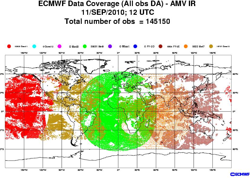
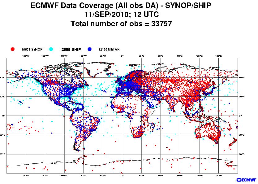
10 Example: Data assimilation for NWP ECMWF assimilated data breakdown

11 Golden Age of Remote Sensing NASA s A-Train 11
 at")
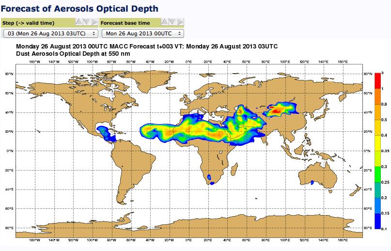
12 Example: Monitoring of Atmospheric Composition & Climate (MACC) at ECMWF
13

14 Carbon Monoxide Forecast
15

16 Cloud Streets over near Greenland from MODIS

17 Monitoring Climate Change: Stratospheric cooling & tropospheric warming with microwave O 2 17
18 A puzzle?
19 There are multiple aspects to remote sensing: Platform (aircraft, satellite, balloon, groundbased) this dictates the time/space sampling characteristics & errors Source of EM Radiation Radiation interaction mechanism Forward and inverse models - this defines the physical and system errors (user in principle has more control over this facet of the system)
20 Observing Platforms Ground-based: Radiometers, sunphotometers, lidar, radar, doppler wind arrays. Local but good time coverage. Aircraft: local-to-regional spatial, limited time coverage (measurement campaigns) Satellite (orbit determines spatial & temporal coverage)

21 Substantial influence on sampling - e.g. synoptic like versus asynoptic
22
23
 suite of imaging spectrometers Weather Climate and Air quality (WCA) option is now entering")
24 HEO Example: PCW-PHEMOS from Environment Canada Polar Communications and Weather (PCW) mission (2017): 2 operational met satellites in Highly Elliptical Orbit (HEO) for quasi-geostationary observations along with a communications package Polar Highly Elliptical Molniya Orbit Science (PHEMOS) suite of imaging spectrometers Weather Climate and Air quality (WCA) option is now entering phase-a study (see talk by J.C. McConnell on Thursday) Quasi-continuous coverage of GHGs over the high latitudes (~40-90 N) using TIR+NIR would help constrain GHG sources/sinks at fine temporal scales Trischenko & Garand (2011) Courtesy Ray Nassar
25 Source of Radiation PASSIVE Sunlight (UV, Vis, Near IR): May be scattered (by atmospheric constituents or surface) or absorbed. Thermal Emission (Thermal IR, microwave, radio) ACTIVE Radar (radio & microwave), GPS (radio) Lidar (visible and near-infrared)
26 Radiation Interactions Extinction Radiation removed from some background source (typically the sun or a laser) Can be removed because of scattering, absorption, or both Emission Adds radiation to a beam because of THERMAL EMISSION (thermal IR & microwave only) Scattering Adds radiation to a beam From clouds, aerosols, or surface. Affects solar & thermal Passive or active
27 Experimental Design Based on some sort of relation defined by a physical process: (a) extinction aerosol OD, TCCON CO2, occultation (b) emission - atmospheric sounding, precipitation,.. (c) scattering - passive, cloud aerosol, ozone,.. - active, radar & lidar
28 The Observing System Transfer Function Physical Variables (T, q, etc) Radiation Signal Key parameters & steps : Measurement, y(t) and error ε y Model f & its error ε f Model parameters b and errors Constraint parameters c Inferred Physical Variables + UNCERTAINTIES!
29 The Retrieval Problem Forward Problem (real) y=f(x) +ε y y = measurement F = Nature s forward model x = parameter desired ε y = error in measurement (noise, calibration error, ) Often the relation between the measurement y and the parameter of interest x is not entirely understood xˆ y=f(,b) + ε y + ε f Inverse Problem x ˆ = I( y, b) b = model parameters that facilitate evaluation of f ε f = error of model
30 PROBLEM: The performance of the system is affected by the performance of the individual parts. Examples of issues: (i) Properly formed forward models [e.g. Z-R relationships, poorly formed forward model without an understanding of what establishes the links between the observable y(z) and the retrieved parameter X(R) ] (ii) Need for prior constraints temperature inversion problem (iii) Poorly formed inverse model: simple regressions or neural network systems might not produce useful errors
31 Inversion versus estimation - radar/rainfall example Stephens, 1994 Radar -rainfall relationship Z= AR b Inversion R= (Z/A) 1/b but A and b are not-unique and vary from rain-type to rain-type implicitly involving some sort of cloud model
32 Non-uniqueness and Instability Cost Function: Φ = M [y-f(x)] measurement Estimation metric of length (e.g. least squares) Prediction of measurement Unconstrained Constrained Φ = M [y-f(x)] + C(x) M M x 1 x 1 C x 2 Solution space non-unique x 2 C(x)= initial or a priori constraint
33 Non-uniqueness and instability: example from emission Physically: z 1 2 Weighting functions that substantially overlap I(0) = B(z )W(0,z )dz Will generally not yield unique solution in the presence of instrument noise & finite # of channels
34 Weighting Functions from a theoretical instrument Results from temperature retrieval project Noiseless Retrieval Realistic noise, proper noise model Realistic noise, assumed noiseless

35 Information Content: The example of IR-based retrieval of water vapor Metric of how much a priori constraint contribute to the retrieval A 0, all a priori, no measurement A 1, no a priori, all measurement
36 Change Calibration (i.e. measurement error by 100%) error Largest impact where measurements contribute most
37 Forward Problem (applied) y = f( f xˆ, b ˆ xˆ, b ˆ ) + ε y + ε f = our depiction of the forward model = estimates of x,y xˆ, b ˆ f / b( b ˆ b) ε f = F(x,b) - f ( ) +, = error in forward model Radiative transfer model (most common) Radiation + physical model Radiation model + NWP (radiance assimilation) For the most challenging problems we encounter, it is generally true that the largest uncertainty arise from forward model errors. If you see error estimates on products that exclude these errors then you ought to be suspicious really suspicious

38 Geostationary allows us to see cloud mov
REVISION OF THE STATEMENT OF GUIDANCE FOR GLOBAL NUMERICAL WEATHER PREDICTION. (Submitted by Dr. J. Eyre)
") WORLD METEOROLOGICAL ORGANIZATION Distr.: RESTRICTED CBS/OPAG-IOS (ODRRGOS-5)/Doc.5, Add.5 (11.VI.2002) COMMISSION FOR BASIC SYSTEMS OPEN PROGRAMME AREA GROUP ON INTEGRATED OBSERVING SYSTEMS ITEM: 4 EXPERT
WORLD METEOROLOGICAL ORGANIZATION Distr.: RESTRICTED CBS/OPAG-IOS (ODRRGOS-5)/Doc.5, Add.5 (11.VI.2002) COMMISSION FOR BASIC SYSTEMS OPEN PROGRAMME AREA GROUP ON INTEGRATED OBSERVING SYSTEMS ITEM: 4 EXPERT
Meteorological Satellite Image Interpretations, Part III. Acknowledgement: Dr. S. Kidder at Colorado State Univ.
 Meteorological Satellite Image Interpretations, Part III Acknowledgement: Dr. S. Kidder at Colorado State Univ. Dates EAS417 Topics Jan 30 Introduction & Matlab tutorial Feb 1 Satellite orbits & navigation
APPLICATIONS WITH METEOROLOGICAL SATELLITES. W. Paul Menzel. Office of Research and Applications NOAA/NESDIS University of Wisconsin Madison, WI
 APPLICATIONS WITH METEOROLOGICAL SATELLITES by W. Paul Menzel Office of Research and Applications NOAA/NESDIS University of Wisconsin Madison, WI July 2004 Unpublished Work Copyright Pending TABLE OF CONTENTS
What are Aerosols? Suspension of very small solid particles or liquid droplets Radii typically in the range of 10nm to
 What are Aerosols? Suspension of very small solid particles or liquid droplets Radii typically in the range of 10nm to 10µm Concentrations decrease exponentially with height N(z) = N(0)exp(-z/H) Long-lived
REMOTE SENSING OF THE ATMOSPHERE AND OCEANS
 EAS 6145 SPRING 2007 REMOTE SENSING OF THE ATMOSPHERE AND OCEANS Instructor: Prof. Irina N. Sokolik office 2258, phone 404-894-6180 isokolik@eas.gatech.edu Meeting Time: Mondays: 3:05-4:25 PM Wednesdays:
Interpretation of Polar-orbiting Satellite Observations. Atmospheric Instrumentation
 Interpretation of Polar-orbiting Satellite Observations Outline Polar-Orbiting Observations: Review of Polar-Orbiting Satellite Systems Overview of Currently Active Satellites / Sensors Overview of Sensor
ATMOS 5140 Lecture 1 Chapter 1
 ATMOS 5140 Lecture 1 Chapter 1 Atmospheric Radiation Relevance for Weather and Climate Solar Radiation Thermal Infrared Radiation Global Heat Engine Components of the Earth s Energy Budget Relevance for
CGMS Baseline. Sustained contributions to the Global Observing System. Endorsed by CGMS-46 in Bengaluru, June 2018
 CGMS Baseline Sustained contributions to the Global Observing System Best Practices for Achieving User Readiness for New Meteorological Satellites Endorsed by CGMS-46 in Bengaluru, June 2018 CGMS/DOC/18/1028862,
Atmospheric Measurements from Space
 Atmospheric Measurements from Space MPI Mainz Germany Thomas Wagner Satellite Group MPI Mainz Part 1: Basics Break Part 2: Applications Part 1: Basics of satellite remote sensing Why atmospheric satellite
Instrumentation planned for MetOp-SG
 Instrumentation planned for MetOp-SG Bill Bell Satellite Radiance Assimilation Group Met Office Crown copyright Met Office Outline Background - the MetOp-SG programme The MetOp-SG instruments Summary Acknowledgements:
Remote Sensing of Precipitation
 Lecture Notes Prepared by Prof. J. Francis Spring 2003 Remote Sensing of Precipitation Primary reference: Chapter 9 of KVH I. Motivation -- why do we need to measure precipitation with remote sensing instruments?
Observing CO 2 from a highly elliptical orbit for studies of the carbon cycle in the Arctic and boreal regions
 Observing CO 2 from a highly elliptical orbit for studies of the carbon cycle in the Arctic and boreal regions Ray Nassar 1, Chris Sioris 2, Dylan B.A. Jones 3, Kaley A. Walker 3, Chris McLinden 4, C.
ATMOSPHERIC SCIENCE-ATS (ATS)
") Atmospheric Science-ATS (ATS) 1 ATMOSPHERIC SCIENCE-ATS (ATS) Courses ATS 150 Science of Global Climate Change Credits: 3 (3-0-0) Physical basis of climate change. Energy budget of the earth, the greenhouse
Atmospheric Science-ATS (ATS) 1 ATMOSPHERIC SCIENCE-ATS (ATS) Courses ATS 150 Science of Global Climate Change Credits: 3 (3-0-0) Physical basis of climate change. Energy budget of the earth, the greenhouse
Chapter 4 Nadir looking UV measurement. Part-I: Theory and algorithm
 Chapter 4 Nadir looking UV measurement. Part-I: Theory and algorithm -Aerosol and tropospheric ozone retrieval method using continuous UV spectra- Atmospheric composition measurements from satellites are
History of Aerosol Remote Sensing. Mark Smithgall Maria Zatko 597K Spring 2009
 History of Aerosol Remote Sensing Mark Smithgall Maria Zatko 597K Spring 2009 Aerosol Sources Anthropogenic Biological decomposition from fertilizer and sewage treatment (ex. ammonium) Combustion of fossil
Numerical Weather Prediction in 2040
 Numerical Weather Prediction in 2040 10.8 µm GEO imagery (simulated!) Peter Bauer, ECMWF Acks.: N. Bormann, C. Cardinali, A. Geer, C. Kuehnlein, C. Lupu, T. McNally, S. English, N. Wedi will not discuss
Lecture 4b: Meteorological Satellites and Instruments. Acknowledgement: Dr. S. Kidder at Colorado State Univ.
 Lecture 4b: Meteorological Satellites and Instruments Acknowledgement: Dr. S. Kidder at Colorado State Univ. US Geostationary satellites - GOES (Geostationary Operational Environmental Satellites) US
Remote Sensing I: Basics
 Remote Sensing I: Basics Kelly M. Brunt Earth System Science Interdisciplinary Center, University of Maryland Cryospheric Science Laboratory, Goddard Space Flight Center kelly.m.brunt@nasa.gov (Based on
Radio Frequency Earth Science
 Radio Frequency Earth Science Overview for Committee On Radio Frequency (CORF) National Academy of Science National Research Council April 27, 2005 Bill.Watson@NASA.Gov Program Executive for Ground Networks
An Air Quality and Greenhouse Gas Mission focused on Northern Regions
 An Air Quality and Greenhouse Gas Mission focused on Northern Regions Ray Nassar * and Chris McLinden Environment and Climate Change Canada *ray.nassar@canada.ca CEOS ACC-12, Yonsei University, Korea,
Remote sensing with FAAM to evaluate model performance
 Remote sensing with FAAM to evaluate model performance YOPP-UK Workshop Chawn Harlow, Exeter 10 November 2015 Contents This presentation covers the following areas Introduce myself Focus of radiation research
Inaugural University of Michigan Science Olympiad Tournament
 Inaugural University of Michigan Science Olympiad Tournament The test may be taken apart. Ties will be broken based on predetermined questions and quality of response. Remote Sensing Test length: 50 Minutes
Remote Sensing in Meteorology: Satellites and Radar. AT 351 Lab 10 April 2, Remote Sensing
 Remote Sensing in Meteorology: Satellites and Radar AT 351 Lab 10 April 2, 2008 Remote Sensing Remote sensing is gathering information about something without being in physical contact with it typically
Remote sensing of ice clouds
 Remote sensing of ice clouds Carlos Jimenez LERMA, Observatoire de Paris, France GDR microondes, Paris, 09/09/2008 Outline : ice clouds and the climate system : VIS-NIR, IR, mm/sub-mm, active 3. Observing
The current status of FY-3D. (Submitted by Xiang Fang, CMA) Summary and Purpose of Document
 Summary and Purpose of Document") WORLD METEOROLOGICAL ORGANIZATION COMMISSION FOR BASIC SYSTEMS OPEN PROGRAMME AREA GROUP ON INTEGRATED OBSERVING SYSTEMS INTER-PROGRAMME EXPERT TEAM ON SATELLITE UTILIZATION AND PRODUCTS FOURTH SESSION
WORLD METEOROLOGICAL ORGANIZATION COMMISSION FOR BASIC SYSTEMS OPEN PROGRAMME AREA GROUP ON INTEGRATED OBSERVING SYSTEMS INTER-PROGRAMME EXPERT TEAM ON SATELLITE UTILIZATION AND PRODUCTS FOURTH SESSION
F O U N D A T I O N A L C O U R S E
 F O U N D A T I O N A L C O U R S E December 6, 2018 Satellite Foundational Course for JPSS (SatFC-J) F O U N D A T I O N A L C O U R S E Introduction to Microwave Remote Sensing (with a focus on passive
The current status of FY-3D
 The current status of FY-3D Xiang Fang National Satellite Meteorological Center, China Meteorological Administration (NSMC/CMA) OUTLINE Overview Key instruments onboard FY-3D Products and data service
ECE 583. xˆ, x ˆ. b ˆ. Lecture 11 Aerosol size distribution retrieval, Gaseous absorber retrieval. Atmospheric Remote Sensing Retrievals
 11-1 ECE 583 Lecture 11 Aerosol size distribution retrieval, Gaseous absorber retrieval The Remote Sensing Retrieval Problem Atmospheric Remote Sensing Retrievals Based on some sort of relation defined
Reminder: All answers MUST GO ON ANSWER SHEET! Answers recorded in the exam booklet will not count.
 Reminder: All answers MUST GO ON ANSWER SHEET! Answers recorded in the exam booklet will not count. 1. Identify the following acronyms; compare these platform types; provide situations where one platform
EUMETSAT STATUS AND PLANS
 1 EUM/TSS/VWG/15/826793 07/10/2015 EUMETSAT STATUS AND PLANS François Montagner, Marine Applications Manager, EUMETSAT WMO Polar Space Task Group 5 5-7 October 2015, DLR, Oberpfaffenhofen PSTG Strategic
Satellite Observations of Greenhouse Gases
 Satellite Observations of Greenhouse Gases Richard Engelen European Centre for Medium-Range Weather Forecasts Outline Introduction Data assimilation vs. retrievals 4D-Var data assimilation Observations
1. The frequency of an electromagnetic wave is proportional to its wavelength. a. directly *b. inversely
 CHAPTER 3 SOLAR AND TERRESTRIAL RADIATION MULTIPLE CHOICE QUESTIONS 1. The frequency of an electromagnetic wave is proportional to its wavelength. a. directly *b. inversely 2. is the distance between successive
Assimilation of Cloud-Affected Infrared Radiances at Environment-Canada
 Assimilation of Cloud-Affected Infrared Radiances at Environment-Canada ECMWF-JCSDA Workshop on Assimilating Satellite Observations of Clouds and Precipitation into NWP models ECMWF, Reading (UK) Sylvain
Christian Sutton. Microwave Water Radiometer measurements of tropospheric moisture. ATOC 5235 Remote Sensing Spring 2003
 Christian Sutton Microwave Water Radiometer measurements of tropospheric moisture ATOC 5235 Remote Sensing Spring 23 ABSTRACT The Microwave Water Radiometer (MWR) is a two channel microwave receiver used
Fundamentals of Atmospheric Radiation and its Parameterization
 Source Materials Fundamentals of Atmospheric Radiation and its Parameterization The following notes draw extensively from Fundamentals of Atmospheric Physics by Murry Salby and Chapter 8 of Parameterization
McIDAS support of Suomi-NPP /JPSS and GOES-R L2
 McIDAS support of Suomi-NPP /JPSS and GOES-R L2 William Straka III 1 Tommy Jasmin 1, Bob Carp 1 1 Cooperative Institute for Meteorological Satellite Studies, Space Science and Engineering Center, University
GCOM-W1 now on the A-Train
 GCOM-W1 now on the A-Train GCOM-W1 Global Change Observation Mission-Water Taikan Oki, K. Imaoka, and M. Kachi JAXA/EORC (& IIS/The University of Tokyo) Mini-Workshop on A-Train Science, March 8 th, 2013
Operational Uses of Bands on the GOES-R Advanced Baseline Imager (ABI) Presented by: Kaba Bah
 Presented by: Kaba Bah") Operational Uses of Bands on the GOES-R Advanced Baseline Imager (ABI) Presented by: Kaba Bah Topics: Introduction to GOES-R & ABI ABI individual bands Use of band differences ABI derived products Conclusions
Operational Uses of Bands on the GOES-R Advanced Baseline Imager (ABI) Presented by: Kaba Bah Topics: Introduction to GOES-R & ABI ABI individual bands Use of band differences ABI derived products Conclusions
EUMETSAT SAF NETWORK. Lothar Schüller, EUMETSAT SAF Network Manager
 1 EUMETSAT SAF NETWORK Lothar Schüller, EUMETSAT SAF Network Manager EUMETSAT ground segment overview METEOSAT JASON-2 INITIAL JOINT POLAR SYSTEM METOP NOAA SATELLITES CONTROL AND DATA ACQUISITION FLIGHT
Lecture 19: Operational Remote Sensing in Visible, IR, and Microwave Channels
 MET 4994 Remote Sensing: Radar and Satellite Meteorology MET 5994 Remote Sensing in Meteorology Lecture 19: Operational Remote Sensing in Visible, IR, and Microwave Channels Before you use data from any
I T A T I O N H B I T B T V A O C J K M R S A T M O S P H E R E
 Word Search Directions: Below are definitions of vocabulary terms. Figure out each term and then find and circle it in the puzzle. Words may appear horizontally, vertically, or diagonally. K E M I S S
Spaceborne Wind Lidar Observations by Aeolus Data Products and Pre-Launch Validation with an Airborne Instrument
 DRAGON 3 Project ID 10532 Cal/Val Spaceborne Wind Lidar Observations by Aeolus Data Products and Pre-Launch Validation with an Airborne Instrument Reitebuch Oliver, Lemmerz Christian, Marksteiner Uwe,
REMOTE SENSING KEY!!
 REMOTE SENSING KEY!! This is a really ugly cover page I m sorry. Name Key. Score / 100 Directions: You have 50 minutes to take this test. You may use a cheatsheet (2 pages), a non-graphing calculator,
Atmospheric Lidar The Atmospheric Lidar (ATLID) is a high-spectral resolution lidar and will be the first of its type to be flown in space.
 is a high-spectral resolution lidar and will be the first of its type to be flown in space.") www.esa.int EarthCARE mission instruments ESA s EarthCARE satellite payload comprises four instruments: the Atmospheric Lidar, the Cloud Profiling Radar, the Multi-Spectral Imager and the Broad-Band Radiometer.
www.esa.int EarthCARE mission instruments ESA s EarthCARE satellite payload comprises four instruments: the Atmospheric Lidar, the Cloud Profiling Radar, the Multi-Spectral Imager and the Broad-Band Radiometer.
HY-2A Satellite User s Guide
 National Satellite Ocean Application Service 2013-5-16 Document Change Record Revision Date Changed Pages/Paragraphs Edit Description i Contents 1 Introduction to HY-2 Satellite... 1 2 HY-2 satellite data
Aerosol Monitoring and Modeling
 Aerosol Monitoring and Modeling Olivier Boucher Presentation to ECMWF seminar on Global Earth-System Monitoring 5-9 September 2005 Page 1 Aerosols are integral part of the Earth s system. CCN f(wind,convection)
Preface to the Second Edition. Preface to the First Edition
 Contents Preface to the Second Edition Preface to the First Edition iii v 1 Introduction 1 1.1 Relevance for Climate and Weather........... 1 1.1.1 Solar Radiation.................. 2 1.1.2 Thermal Infrared
CLIMATE CHANGE Albedo Forcing ALBEDO FORCING
 ALBEDO FORCING Albedo forcing is the hypothesis that variations in the Earth s reflectance of solar radiation can bring about global climate change. This hypothesis is undeniable in principle; since virtually
Atmospheric Basics AOSC 200 Tim Canty
 Atmospheric Basics AOSC 200 Tim Canty Class Web Site: http://www.atmos.umd.edu/~tcanty/aosc200 Topics for today: Structure of the Atmosphere Temperature vs height Atmospheric pressure Atmospheric composition
1. CLIMATOLOGY: 2. ATMOSPHERIC CHEMISTRY:
 What is meteorology? A. METEOROLOGY: an atmospheric science that studies the day to day changes in the atmosphere 1. ATMOSPHERE: the blanket of gas that surrounds the surface of Earth; the air 2. WEATHER:
GIFTS SOUNDING RETRIEVAL ALGORITHM DEVELOPMENT
 P2.32 GIFTS SOUNDING RETRIEVAL ALGORITHM DEVELOPMENT Jun Li, Fengying Sun, Suzanne Seemann, Elisabeth Weisz, and Hung-Lung Huang Cooperative Institute for Meteorological Satellite Studies (CIMSS) University
OSSE to infer the impact of Arctic AMVs extracted from highly elliptical orbit imagery
 OSSE to infer the impact of Arctic AMVs extracted from highly elliptical orbit imagery L. Garand 1 Y. Rochon 1, S. Heilliette 1, J. Feng 1, A.P. Trishchenko 2 1 Environment Canada, 2 Canada Center for
Spectrum of Radiation. Importance of Radiation Transfer. Radiation Intensity and Wavelength. Lecture 3: Atmospheric Radiative Transfer and Climate
 Lecture 3: Atmospheric Radiative Transfer and Climate Radiation Intensity and Wavelength frequency Planck s constant Solar and infrared radiation selective absorption and emission Selective absorption
Assimilation of Satellite Cloud and Precipitation Observations in NWP Models: Report of a Workshop
 Assimilation of Satellite Cloud and Precipitation Observations in NWP Models: Report of a Workshop George Ohring and Fuzhong Weng Joint Center for Satellite Data Assimilation Ron Errico NASA/GSFC Global
Once a specific data set is selected, NEO will list related data sets in the panel titled Matching Datasets, which is to the right of the image.
 NASA Earth Observations (NEO): A Brief Introduction NEO is a data visualization tool that allows users to explore a wealth of environmental data collected by NASA satellites. The satellites use an array
Lecture 3: Atmospheric Radiative Transfer and Climate
 Lecture 3: Atmospheric Radiative Transfer and Climate Solar and infrared radiation selective absorption and emission Selective absorption and emission Cloud and radiation Radiative-convective equilibrium
Geodetics measurements within the scope of current and future perspectives of GNSS-Reflectometry and GNSS-Radio Occultation
 Geodetics measurements within the scope of current and future perspectives of GNSS-Reflectometry and GNSS-Radio Occultation Introduction The aim of this presentation is to provide an overview of the GNSS-R
Satellite Imagery and Virtual Global Cloud Layer Simulation from NWP Model Fields
 Satellite Imagery and Virtual Global Cloud Layer Simulation from NWP Model Fields John F. Galantowicz John J. Holdzkom Thomas Nehrkorn Robert P. D Entremont Steve Lowe AER Atmospheric and Environmental
CMA Consideration on early-morning orbit satellite
 CMA Consideration on early-morning orbit satellite National Satellite Meteorological Center,CMA Yang Jun CGMS 40 in Lugano, 5-9 Nov., 2012 Outline Background Gap analysis on the sounding data coverage
IMPORTANCE OF SATELLITE DATA (FOR REANALYSIS AND BEYOND) Jörg Schulz EUMETSAT
 Jörg Schulz EUMETSAT") IMPORTANCE OF SATELLITE DATA (FOR REANALYSIS AND BEYOND) Jörg Schulz EUMETSAT Why satellite data for climate monitoring? Global coverage Global consistency, sometimes also temporal consistency High spatial
IMPORTANCE OF SATELLITE DATA (FOR REANALYSIS AND BEYOND) Jörg Schulz EUMETSAT Why satellite data for climate monitoring? Global coverage Global consistency, sometimes also temporal consistency High spatial
PHEOS - Weather, Climate, Air Quality
 Aerosol & cloud remote sensing over the Arctic : perspectives for the PHEMOS and meteorological imager payloads on the PCW mission Norm O Neill, Auromeet Saha, U. de Sherbrooke Chris E. Sioris, Jack McConnell,
Monitoring Climate Change from Space
 Monitoring Climate Change from Space Richard Allan (email: r.p.allan@reading.ac.uk twitter: @rpallanuk) Department of Meteorology, University of Reading Why Monitor Earth s Climate from Space? Global Spectrum
Lecture Outlines PowerPoint. Chapter 16 Earth Science 11e Tarbuck/Lutgens
 Lecture Outlines PowerPoint Chapter 16 Earth Science 11e Tarbuck/Lutgens 2006 Pearson Prentice Hall This work is protected by United States copyright laws and is provided solely for the use of instructors
Ocean-Atmosphere Fluxes & Marine Meteorology
 Ocean-Atmosphere Fluxes & Marine Meteorology Breakout Group Questions How can the CND be enhanced to better address this science theme? What other approaches could be combined with the observatory elements
MSG system over view
 MSG system over view 1 Introduction METEOSAT SECOND GENERATION Overview 2 MSG Missions and Services 3 The SEVIRI Instrument 4 The MSG Ground Segment 5 SAF Network 6 Conclusions METEOSAT SECOND GENERATION
Status of Indian Satellite Meteorological Programme
 Status of Indian Satellite Meteorological Programme Pradeep K Thapliyal Space Applications Centre (SAC) Indian Space research Organisation (ISRO) Ahmedabad (INDIA) Email: pkthapliyal@sac.isro.gov.in International
WMO OSCAR. Observing Systems Capability Analysis and Review Tool A building block of Rolling Requirements Review
 WMO OSCAR Observing Systems Capability Analysis and Review Tool A building block of Rolling Requirements Review Quantitative user-defined requirements for observation of physical variables in application
The Atmosphere and Atmospheric Energy Chapter 3 and 4
 The Atmosphere and Atmospheric Energy Chapter 3 and 4 Size of the Earth s Atmosphere Atmosphere produced over 4.6 billion years of development Protects us from radiation Completely surrounds the earth
Projects in the Remote Sensing of Aerosols with focus on Air Quality
 Projects in the Remote Sensing of Aerosols with focus on Air Quality Faculty Leads Barry Gross (Satellite Remote Sensing), Fred Moshary (Lidar) Direct Supervision Post-Doc Yonghua Wu (Lidar) PhD Student
Polar Mesospheric Clouds and Cosmic Dust: Three years of SOFIE Measurements
 Polar Mesospheric Clouds and Cosmic Dust: Three years of SOFIE Measurements SOFIE = the Solar Occultation For Ice Experiment, aboard AIM, NASA s Aeronomy of Ice in the Mesosphere mission Marty McHugh,
EPS-SG Candidate Observation Missions
 EPS-SG Candidate Observation Missions 3 rd Post-EPS User Consultation Workshop Peter Schlüssel Slide: 1 EPS-SG benefits to activities of NMSs Main Payload High-Resolution Infrared Sounding Microwave Sounding
Future Opportunities of Using Microwave Data from Small Satellites for Monitoring and Predicting Severe Storms
 Future Opportunities of Using Microwave Data from Small Satellites for Monitoring and Predicting Severe Storms Fuzhong Weng Environmental Model and Data Optima Inc., Laurel, MD 21 st International TOV
Satellite data assimilation for Numerical Weather Prediction II
 Satellite data assimilation for Numerical Weather Prediction II Niels Bormann European Centre for Medium-range Weather Forecasts (ECMWF) (with contributions from Tony McNally, Jean-Noël Thépaut, Slide
Spatial Variability of Aerosol - Cloud Interactions over Indo - Gangetic Basin (IGB)
") Spatial Variability of Aerosol - Cloud Interactions over Indo - Gangetic Basin (IGB) Shani Tiwari Graduate School of Environmental Studies Nagoya University, Nagoya, Japan Email: pshanitiwari@gmail.com
Spatial Variability of Aerosol - Cloud Interactions over Indo - Gangetic Basin (IGB) Shani Tiwari Graduate School of Environmental Studies Nagoya University, Nagoya, Japan Email: pshanitiwari@gmail.com
Polar winds from highly elliptical orbiting satellites: a new perspective
 Polar winds from highly elliptical orbiting satellites: a new perspective 10 th International Winds Workshop Tokyo, Japan, Feb -6, 010 L. Garand 1, N. Wagneur 1, R. Sarrazin 1, D. Santek, J. Key 1 Environment
Observational Needs for Polar Atmospheric Science
 Observational Needs for Polar Atmospheric Science John J. Cassano University of Colorado with contributions from: Ed Eloranta, Matthew Lazzara, Julien Nicolas, Ola Persson, Matthew Shupe, and Von Walden
The Structure and Motion of the Atmosphere OCEA 101
 The Structure and Motion of the Atmosphere OCEA 101 Why should you care? - the atmosphere is the primary driving force for the ocean circulation. - the atmosphere controls geographical variations in ocean
This presentation was assembled as part of the outreach initiative for the Canadian Network for the Detection of Atmospheric Change.
 This will be a lesson for students in grades 9-12. The subject matter is climate change - the greenhouse effect, greenhouse gases, how greenhouse gases are measured and studied, and the impacts of climate
The EarthCARE mission: An active view on aerosols, clouds and radiation
 The EarthCARE mission: An active view on aerosols, clouds and radiation T. Wehr, P. Ingmann, T. Fehr Heraklion, Crete, Greece 08/06/2015 EarthCARE is ESA s sixths Earth Explorer Mission and will be implemented
PRINCIPLES OF REMOTE SENSING. Electromagnetic Energy and Spectral Signatures
 PRINCIPLES OF REMOTE SENSING Electromagnetic Energy and Spectral Signatures Remote sensing is the science and art of acquiring and analyzing information about objects or phenomena from a distance. As humans,
CGMS Baseline In response to CGMS action/recommendation A45.01 HLPP reference: 1.1.8
 Prepared by WGIII Agenda Item: 7.1 Discussed in WGIII CGMS Baseline In response to CGMS action/recommendation A45.01 HLPP reference: 1.1.8 In CGMS-45, Working Group III agreed to hold a review of the CGMS
Chapter 10 Planetary Atmospheres Earth and the Other Terrestrial Worlds. What is an atmosphere? Planetary Atmospheres
 Chapter 10 Planetary Atmospheres Earth and the Other Terrestrial Worlds What is an atmosphere? Planetary Atmospheres Pressure Composition Greenhouse effect Atmospheric structure Color of the sky 1 Atmospheres
Lecture 4: Radiation Transfer
 Lecture 4: Radiation Transfer Spectrum of radiation Stefan-Boltzmann law Selective absorption and emission Reflection and scattering Remote sensing Importance of Radiation Transfer Virtually all the exchange
Lectures 7 and 8: 14, 16 Oct Sea Surface Temperature
 Lectures 7 and 8: 14, 16 Oct 2008 Sea Surface Temperature References: Martin, S., 2004, An Introduction to Ocean Remote Sensing, Cambridge University Press, 454 pp. Chapter 7. Robinson, I. S., 2004, Measuring
Lecture 6: Radiation Transfer. Global Energy Balance. Reflection and Scattering. Atmospheric Influences on Insolation
 Lecture 6: Radiation Transfer Global Energy Balance terrestrial radiation cooling Solar radiation warming Global Temperature atmosphere Vertical and latitudinal energy distributions Absorption, Reflection,
Lecture 6: Radiation Transfer
 Lecture 6: Radiation Transfer Vertical and latitudinal energy distributions Absorption, Reflection, and Transmission Global Energy Balance terrestrial radiation cooling Solar radiation warming Global Temperature
Retrieval Algorithm Using Super channels
 Retrieval Algorithm Using Super channels Xu Liu NASA Langley Research Center, Hampton VA 23662 D. K. Zhou, A. M. Larar (NASA LaRC) W. L. Smith (HU and UW) P. Schluessel (EUMETSAT) Hank Revercomb (UW) Jonathan
Satellite observation of atmospheric dust
 Satellite observation of atmospheric dust Taichu Y. Tanaka Meteorological Research Institute, Japan Meteorological Agency 11 April 2017, SDS WAS: Dust observation and modeling @WMO, Geneva Dust observations
EUMETSAT Beitrag zu CAMS und C3S. Jörg Schulz. Credits to many EUMETSAT Staff
 ETSAT Beitrag zu CAMS und C3S Jörg Schulz Credits to many ETSAT Staff The Copernicus Programme at ETSAT ETSAT is entrusted by the European Commission; ETSAT s Delegation Agreement is organised in 3 major
The Retrieval of Infrared Cooling Rate Profiles from Thermal Infrared Remote Sounder Radiance Measurements
 The Retrieval of Infrared Cooling Rate Profiles from Thermal Infrared Remote Sounder Radiance Measurements Daniel Feldman Candidacy Presentation May 13, 2005 Outline 1. Background 2. Motivation 3. Cooling
Data Short description Parameters to be used for analysis SYNOP. Surface observations by ships, oil rigs and moored buoys
 3.2 Observational Data 3.2.1 Data used in the analysis Data Short description Parameters to be used for analysis SYNOP Surface observations at fixed stations over land P,, T, Rh SHIP BUOY TEMP PILOT Aircraft
Applications of the SEVIRI window channels in the infrared.
 Applications of the SEVIRI window channels in the infrared jose.prieto@eumetsat.int SEVIRI CHANNELS Properties Channel Cloud Gases Application HRV 0.7 Absorption Scattering
Mon Oct 20. Today: radiation and temperature (cont) sun-earth geometry energy balance >> conceptual model of climate change Tues:
 sun-earth geometry energy balance >> conceptual model of climate change Tues:") Mon Oct 20 Announcements: bring calculator to class from now on > in-class activities > midterm and final Today: radiation and temperature (cont) sun-earth geometry energy balance >> conceptual model of
Mon Oct 20 Announcements: bring calculator to class from now on > in-class activities > midterm and final Today: radiation and temperature (cont) sun-earth geometry energy balance >> conceptual model of
Next generation of EUMETSAT microwave imagers and sounders: new opportunities for cloud and precipitation retrieval
 Next generation of EUMETSAT microwave imagers and sounders: new opportunities for cloud and precipitation retrieval Christophe Accadia, Sabatino Di Michele, Vinia Mattioli, Jörg Ackermann, Sreerekha Thonipparambil,
GEMS/MACC Assimilation of IASI
 GEMS/MACC Assimilation of IASI Richard Engelen Many thanks to the GEMS team. Outline The GEMS and MACC projects Assimilation of IASI CO retrievals Why do we prefer radiance assimilation? IASI CH 4 : bias
The last 2 million years.
 Lecture 5: Earth Climate History - Continued Ice core records from both Greenland and Antarctica have produced a remarkable record of climate during the last 450,000 years. Trapped air bubbles provide
Effects of Black Carbon on Temperature Lapse Rates
 Effects of Black Carbon on Temperature Lapse Rates Joyce E. Penner 1 Minghuai Wang 1, Akshay Kumar 1, Leon Rotstayn 2, Ben Santer 1 University of Michigan, 2 CSIRO, 3 LLNL Thanks to Warren Washington and
Earth: the Goldilocks Planet
 Earth: the Goldilocks Planet Not too hot (460 C) Fig. 3-1 Not too cold (-55 C) Wave properties: Wavelength, velocity, and? Fig. 3-2 Reviewing units: Wavelength = distance (meters or nanometers, etc.) Velocity
Climate Change: Global Warming Claims
 Climate Change: Global Warming Claims Background information (from Intergovernmental Panel on Climate Change): The climate system is a complex, interactive system consisting of the atmosphere, land surface,
Unit 3 Review Guide: Atmosphere
 Unit 3 Review Guide: Atmosphere Atmosphere: A thin layer of gases that forms a protective covering around the Earth. Photosynthesis: Process where plants take in carbon dioxide and release oxygen. Trace