Satellite Imagery and Virtual Global Cloud Layer Simulation from NWP Model Fields
|
|
|
- David Sutton
- 5 years ago
- Views:
Transcription
1 Satellite Imagery and Virtual Global Cloud Layer Simulation from NWP Model Fields John F. Galantowicz John J. Holdzkom Thomas Nehrkorn Robert P. D Entremont Steve Lowe AER Atmospheric and Environmental Research, Inc. Lexington, MA johng@aer.com 1
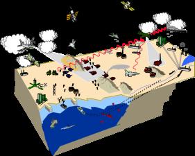
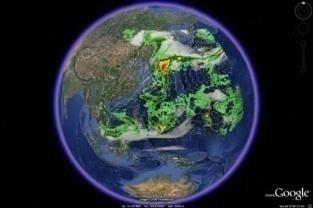
2 Overview Purpose Use NWP imbedded in global reanalyses to create detailed environment representations for: Simulation-based training exercises (e.g., DoD, FEMA) Sensor performance studies (e.g., remote sensing, tactical) Products 1. Simulated operational imagery including: GEO satellite: Visible, thermal infrared, and water vapor bands Precipitation radar 2. Cloud layer visualizations for virtual globes Google Earth examples are presented here 2
3 Requirements EDCSS Environmental Data Cube Support System (DoD) Consistent environment representations for simulation community See Holdzkom et al., 26IIPS 5A.1 Satellite imagery common weather product for situational awareness Goal is to match look and formats of operational imagery Virtual globes integrated situational awareness tools Initial goal is to include realistic cloud representations Imagery generated from NWP model fields Must be consistent with other EDCSS products e.g., METAR, charts, grib, graphics up to 5000 per exercise Must be self-consistent e.g., between imagery types and temporally, spatially, spectrally Must be convincingly real to end-users AND completely consistent with underlying model representation e.g., allow cloud top height to be interpreted from temperature 3


")

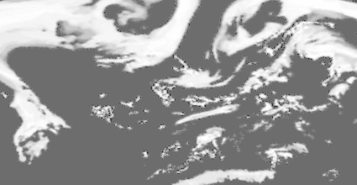
4 Simulated operational imagery (from hourly WRF model fields) visible window IR water vapor IR RADAR 4
5 Interpretation of NWP fields Source models used (to date) WRF, COAMPS, MASS in NCEP & ERA-40 reanalyses Typical parameter set (input or derived) 2D: Skin temperature, precipitable water column, wind vector, convective and total precipitation, 2 m dew point, 2 m air temperature 3D: Temperature, water vapor, geopotential height, hydrometeors (total of liquid, ice, snow, & grauple) Consistency check WRF example Problem: Subgrid convective processes in WRF can produce precipitation where cloud water fields are zero Solution: 1. Compute an ad hoc alternative cloud water profile based on temperature, pressure, and convective precipitation rate 2. Compute a second ad hoc alternative cloud water profile for areas where RH is very high (i.e., cloud margins) 3. Use maximum of WRF cloud water fields and ad hoc alternatives 5


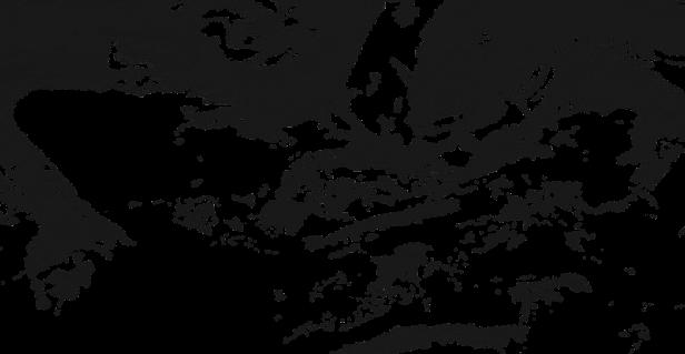
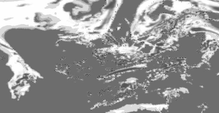
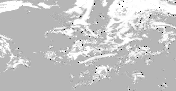
6 WRF clouds vs. ad hoc solution WRF clouds only WRF clouds + ad hoc clouds Closer to operational imagery from the same time period 6


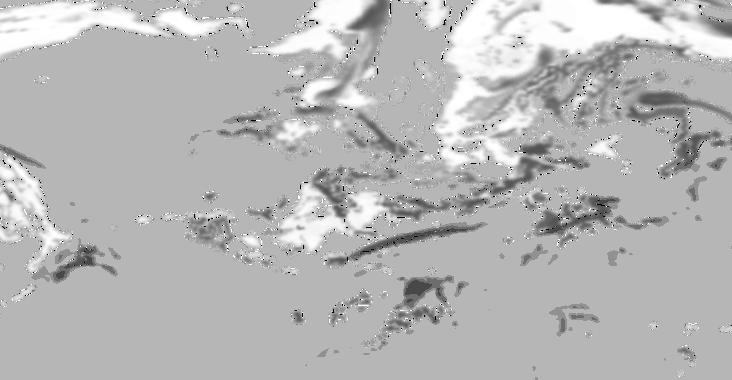
7 Clouds vs. total precipitation WRF clouds only WRF clouds + ad hoc clouds More consistent with rain extent 7
8 Radiative transfer methods Visible Solar-illuminated window band OSS/Charts: 4-streams, Weinreb & Hill WV model, molecular scattering Uses cloud scattering/absorption profile Water: Cox & Munk wind-dependent sun glint Land: MODIS land surface reflectance Window IR Thermal emission window band (no sun) OSS/Charts: 4-streams, Weinreb & Hill WV model Uses cloud absorption/emission profile (scattering neglected) Simple ocean/land LUT emissivities Water Vapor IR Thermal emission absorption band (no sun) Optical thickness profile LUT tabulated offline for 3 atmospheres Subarctic, mid-latitude, tropic Interpolate on LUT by precipitable water inputs Add cloud absorption/emission profile (scattering neglected) Simple 2-stream radiative transfer Simple ocean/land LUT emissivities 8
9 Satellite imagery vs. virtual global visualization Satellite VG VG Visualization Approach Constant viewing geometry (top-ofatmosphere only) Omni-directional viewing possible within & above atmosphere 2-sided cloud layers (separate up & down views) High clouds shadow low clouds Parallax gives quasi-3d effect Sensor response: image brightness scale is known Earth background can be modeled from remote sensing data Eye-response: brightness scale is relative* VG base imagery background is variable Constant solar zenith angle except near terminator Add twilight illumination Scale images relative to top-ofatmosphere brightness RT uses constant earth reflectivity Terrain overlay shadow is included with cloud layers in VG * Google Earth sun affects overlay image appearance near terminator and at night 9
10 VG visualization approach WRF: 36 levels 3-level VG visualization 100 mb Pre-selected VG layer levels (MSL) Overview image visible only from high-altitude view (KML-controlled) cloud 8 km Top-side image Bottom-side image 6 km Viewer cloud cloud 2 km z = 0 4 km 1 km Top-side image Bottom-side image Top-side image Bottom-side image Terrain overlay shadow 8 images, 1 KML file 10
11 VG visualization approach Image brightness Illumination attenuated by layers above Image transparency Layer transmittance/extinction controls image transparency For transparent layers (e.g., cloudfree) image brightness is moot 6 km Top-side image: up-welling brightness at top of layer 6 km 2 km Compute layer extinction (loss factor) 4 km-level images For a two-image VG layer: 2 km Constant earth surface reflectivity Bottom-side image: down-welling brightness at bottom of layer Image extinction = sqrt(layer extinction) Image transparency = 1 (image extinction) 11
12 3-level VG visualization images Bottom side views Top side views 8 km 4 km Terrain overlay shadow 1 km 12
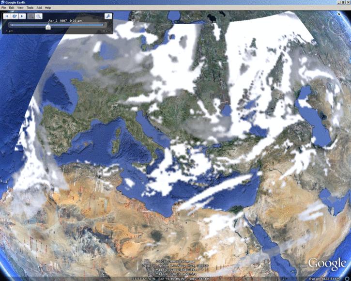
13 Top-of-atmosphere view 13

14 Oblique view facing W, 6 km altitude 14

15 Oblique view facing W, 2.5 km altitude 15


16 Oblique view facing W, 900 m altitude With terrain shadow Without terrain shadow Spathades, Greece 16
17 Potential areas for VG cloud visualization improvement Calibrate image brightness to virtual globe base imagery Use objective eye-response function More than 3 visualization layers Impact on VG refresh performance Include fog in terrain overlay (i.e., obscure base imagery) Higher resolution NWP model grid e.g., at ~3 km convective processes can be resolved (subgrid convective parameterizations turned off) Use alternative WRF physics packages (in implementation) WRF double-moment bulk microphysics scheme Grell-Devenyi convective scheme (vs. Kain-Fritsch) 17
18 Summary It is feasible to place quasi-3d cloud visualizations in virtual globe applications that are both physically consistent with NWP model fields and visually realistic Adaptations are required for non-physical aspects of the VG environment For the future: Cloud visualizations within the Google Earth platform that are closer to true 3D while meeting physicalconsistency requirements 18

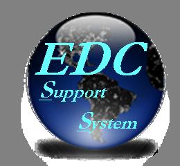


19 1. Build an Integrated Environment Representation The EDCSS program is sponsored by Air Force Weather and the DoD Modeling and Simulation Coordinating Office (MSCO) Environmental Data Cube Support System (EDCSS) 2. Produce a full suite of support products IER 3. Distribute during event execution 19
Lecture 4: Radiation Transfer
 Lecture 4: Radiation Transfer Spectrum of radiation Stefan-Boltzmann law Selective absorption and emission Reflection and scattering Remote sensing Importance of Radiation Transfer Virtually all the exchange
Remote Sensing in Meteorology: Satellites and Radar. AT 351 Lab 10 April 2, Remote Sensing
 Remote Sensing in Meteorology: Satellites and Radar AT 351 Lab 10 April 2, 2008 Remote Sensing Remote sensing is gathering information about something without being in physical contact with it typically
Lecture 19: Operational Remote Sensing in Visible, IR, and Microwave Channels
 MET 4994 Remote Sensing: Radar and Satellite Meteorology MET 5994 Remote Sensing in Meteorology Lecture 19: Operational Remote Sensing in Visible, IR, and Microwave Channels Before you use data from any
Course outline, objectives, workload, projects, expectations
 Course outline, objectives, workload, projects, expectations Introductions Remote Sensing Overview Elements of a remote sensing observing system 1. platform (satellite, surface, etc) 2. experimental design
Moisture, Clouds, and Precipitation: Clouds and Precipitation. Dr. Michael J Passow
 Moisture, Clouds, and Precipitation: Clouds and Precipitation Dr. Michael J Passow What Processes Lift Air? Clouds require three things: water vapor, a condensation nucleus, and cooling Cooling usually
APPLICATIONS WITH METEOROLOGICAL SATELLITES. W. Paul Menzel. Office of Research and Applications NOAA/NESDIS University of Wisconsin Madison, WI
 APPLICATIONS WITH METEOROLOGICAL SATELLITES by W. Paul Menzel Office of Research and Applications NOAA/NESDIS University of Wisconsin Madison, WI July 2004 Unpublished Work Copyright Pending TABLE OF CONTENTS
F O U N D A T I O N A L C O U R S E
 F O U N D A T I O N A L C O U R S E December 6, 2018 Satellite Foundational Course for JPSS (SatFC-J) F O U N D A T I O N A L C O U R S E Introduction to Microwave Remote Sensing (with a focus on passive
Preface to the Second Edition. Preface to the First Edition
 Contents Preface to the Second Edition Preface to the First Edition iii v 1 Introduction 1 1.1 Relevance for Climate and Weather........... 1 1.1.1 Solar Radiation.................. 2 1.1.2 Thermal Infrared
Weather Forecasting: Lecture 2
 Weather Forecasting: Lecture 2 Dr. Jeremy A. Gibbs Department of Atmospheric Sciences University of Utah Spring 2017 1 / 40 Overview 1 Forecasting Techniques 2 Forecast Tools 2 / 40 Forecasting Techniques
LARGE-SCALE WRF-SIMULATED PROXY ATMOSPHERIC PROFILE DATASETS USED TO SUPPORT GOES-R RESEARCH ACTIVITIES
 LARGE-SCALE WRF-SIMULATED PROXY ATMOSPHERIC PROFILE DATASETS USED TO SUPPORT GOES-R RESEARCH ACTIVITIES Jason Otkin, Hung-Lung Huang, Tom Greenwald, Erik Olson, and Justin Sieglaff Cooperative Institute
Future Opportunities of Using Microwave Data from Small Satellites for Monitoring and Predicting Severe Storms
 Future Opportunities of Using Microwave Data from Small Satellites for Monitoring and Predicting Severe Storms Fuzhong Weng Environmental Model and Data Optima Inc., Laurel, MD 21 st International TOV
McIDAS Activities Within The NASA Langley Research Center Clouds And Radiation Group
 McIDAS Activities Within The NASA Langley Research Center Clouds And Radiation Group Kristopher Bedka Science Systems and Applications Inc @ NASA LaRC In Collaboration With (in alphabetical order) J. K.
Meteorological Satellite Image Interpretations, Part III. Acknowledgement: Dr. S. Kidder at Colorado State Univ.
 Meteorological Satellite Image Interpretations, Part III Acknowledgement: Dr. S. Kidder at Colorado State Univ. Dates EAS417 Topics Jan 30 Introduction & Matlab tutorial Feb 1 Satellite orbits & navigation
APPENDIX 2 OVERVIEW OF THE GLOBAL PRECIPITATION MEASUREMENT (GPM) AND THE TROPICAL RAINFALL MEASURING MISSION (TRMM) 2-1
 AND THE TROPICAL RAINFALL MEASURING MISSION (TRMM) 2-1") APPENDIX 2 OVERVIEW OF THE GLOBAL PRECIPITATION MEASUREMENT (GPM) AND THE TROPICAL RAINFALL MEASURING MISSION (TRMM) 2-1 1. Introduction Precipitation is one of most important environmental parameters.
APPENDIX 2 OVERVIEW OF THE GLOBAL PRECIPITATION MEASUREMENT (GPM) AND THE TROPICAL RAINFALL MEASURING MISSION (TRMM) 2-1 1. Introduction Precipitation is one of most important environmental parameters.
Probability of Cloud-Free-Line-of-Sight (PCFLOS) Derived From CloudSat and CALIPSO Cloud Observations
 Derived From CloudSat and CALIPSO Cloud Observations") Probability of Cloud-Free-Line-of-Sight (PCFLOS) Derived From CloudSat and CALIPSO Cloud Observations Donald L. Reinke, Thomas H. Vonder Haar Cooperative Institute for Research in the Atmosphere Colorado
Probability of Cloud-Free-Line-of-Sight (PCFLOS) Derived From CloudSat and CALIPSO Cloud Observations Donald L. Reinke, Thomas H. Vonder Haar Cooperative Institute for Research in the Atmosphere Colorado
How to display RGB imagery by SATAID
 How to display RGB imagery by SATAID Akihiro SHIMIZU Meteorological Satellite Center (MSC), Japan Meteorological Agency (JMA) Ver. 2015110500 RGB imagery on SATAID SATAID software has a function of overlapping
Menzel/Matarrese/Puca/Cimini/De Pasquale/Antonelli Lab 2 Ocean Properties inferred from MODIS data June 2006
 Menzel/Matarrese/Puca/Cimini/De Pasquale/Antonelli Lab 2 Ocean Properties inferred from MODIS data June 2006 Table: MODIS Channel Number, Wavelength (µm), and Primary Application Reflective Bands Emissive
Climate & Earth System Science. Introduction to Meteorology & Climate. Chapter 05 SOME OBSERVING INSTRUMENTS. Instrument Enclosure.
 Climate & Earth System Science Introduction to Meteorology & Climate MAPH 10050 Peter Lynch Peter Lynch Meteorology & Climate Centre School of Mathematical Sciences University College Dublin Meteorology
Remote Sensing of Precipitation
 Lecture Notes Prepared by Prof. J. Francis Spring 2003 Remote Sensing of Precipitation Primary reference: Chapter 9 of KVH I. Motivation -- why do we need to measure precipitation with remote sensing instruments?
Aviation Hazards: Thunderstorms and Deep Convection
 Aviation Hazards: Thunderstorms and Deep Convection TREND Diagnosis of thunderstorm hazards using imagery Contents Satellite imagery Visible, infrared, water vapour Basic cloud identification Identifying
The WMO Aviation Research & Demonstration Project (AvRDP) at Paris-CDG airport. Pauline Jaunet Météo-France
 at Paris-CDG airport. Pauline Jaunet Météo-France") The WMO Aviation Research & Demonstration Project (AvRDP) at Paris-CDG airport Pauline Jaunet Météo-France AvRDP focus points Aviation Research Demonstration Project Joint effort between CAS/WWRP and CaeM
The WMO Aviation Research & Demonstration Project (AvRDP) at Paris-CDG airport Pauline Jaunet Météo-France AvRDP focus points Aviation Research Demonstration Project Joint effort between CAS/WWRP and CaeM
On the Satellite Determination of Multilayered Multiphase Cloud Properties. Science Systems and Applications, Inc., Hampton, Virginia 2
 JP1.10 On the Satellite Determination of Multilayered Multiphase Cloud Properties Fu-Lung Chang 1 *, Patrick Minnis 2, Sunny Sun-Mack 1, Louis Nguyen 1, Yan Chen 2 1 Science Systems and Applications, Inc.,
Using the CRTM and GOES Observations to Improve Model Microphysics
 Using the CRTM and GOES Observations to Improve Model Microphysics Dan Lindsey NOAA Center for Satellite Applications and Research, CIRA, Ft. Collins, CO Louie Grasso, Yoo-Jeong Noh, Steve Miller, Curtis
Incorporation of 3D Shortwave Radiative Effects within the Weather Research and Forecasting Model
 Incorporation of 3D Shortwave Radiative Effects within the Weather Research and Forecasting Model W. O Hirok and P. Ricchiazzi Institute for Computational Earth System Science University of California
Applications of the SEVIRI window channels in the infrared.
 Applications of the SEVIRI window channels in the infrared jose.prieto@eumetsat.int SEVIRI CHANNELS Properties Channel Cloud Gases Application HRV 0.7 Absorption Scattering
Assimilation of Satellite Cloud and Precipitation Observations in NWP Models: Report of a Workshop
 Assimilation of Satellite Cloud and Precipitation Observations in NWP Models: Report of a Workshop George Ohring and Fuzhong Weng Joint Center for Satellite Data Assimilation Ron Errico NASA/GSFC Global
Table 1-2. TMY3 data header (line 2) 1-68 Data field name and units (abbreviation or mnemonic)
 1-68 Data field name and units (abbreviation or mnemonic)") 1.4 TMY3 Data Format The format for the TMY3 data is radically different from the TMY and TMY2 data.. The older TMY data sets used columnar or positional formats, presumably as a method of optimizing data
1.4 TMY3 Data Format The format for the TMY3 data is radically different from the TMY and TMY2 data.. The older TMY data sets used columnar or positional formats, presumably as a method of optimizing data
INTERPRETATION OF MSG IMAGES, PRODUCTS AND SAFNWC OUTPUTS FOR DUTY FORECASTERS
 INTERPRETATION OF MSG IMAGES, PRODUCTS AND SAFNWC OUTPUTS FOR DUTY FORECASTERS M. Putsay, M. Rajnai, M. Diószeghy, J. Kerényi, I.G. Szenyán and S. Kertész Hungarian Meteorological Service, H-1525 Budapest,
Weather Forecasting. March 26, 2009
 Weather Forecasting Chapter 13 March 26, 2009 Forecasting The process of inferring weather from a blend of data, understanding, climatology, and solutions of the governing equations Requires an analysis
RTTOV 10 Theory & Exercise
 RTTOV 10 Theory & Exercise Ø Overview of RTTOVS Radiative Transfer Model q Gases Absorption (water Vapor & other trace gases) q Aerosol/Clouds Scattering and Absorption q Surface Emissivity/Reflectivity
Variational data assimilation of lightning with WRFDA system using nonlinear observation operators
 Variational data assimilation of lightning with WRFDA system using nonlinear observation operators Virginia Tech, Blacksburg, Virginia Florida State University, Tallahassee, Florida rstefane@vt.edu, inavon@fsu.edu
Simulated MSG SEVIRI Imagery from HARMONIE-AROME
 Simulated MSG SEVIRI Imagery from HARMONIE-AROME Angeles Hernandez, AEMET Joint 28th ALADIN Workshop & HIRLAM All-Staff Meeting 2018 - Toulouse, 16-20 Apr 2018 Outline 1. Simulated Satellite Images (SSI)
REVISION OF THE STATEMENT OF GUIDANCE FOR GLOBAL NUMERICAL WEATHER PREDICTION. (Submitted by Dr. J. Eyre)
") WORLD METEOROLOGICAL ORGANIZATION Distr.: RESTRICTED CBS/OPAG-IOS (ODRRGOS-5)/Doc.5, Add.5 (11.VI.2002) COMMISSION FOR BASIC SYSTEMS OPEN PROGRAMME AREA GROUP ON INTEGRATED OBSERVING SYSTEMS ITEM: 4 EXPERT
WORLD METEOROLOGICAL ORGANIZATION Distr.: RESTRICTED CBS/OPAG-IOS (ODRRGOS-5)/Doc.5, Add.5 (11.VI.2002) COMMISSION FOR BASIC SYSTEMS OPEN PROGRAMME AREA GROUP ON INTEGRATED OBSERVING SYSTEMS ITEM: 4 EXPERT
The Purdue Lin Microphysics Scheme in WRF. Russ Schumacher AT 730 Final Project 26 April 2006
 The Purdue Lin Microphysics Scheme in WRF Russ Schumacher AT 730 Final Project 26 April 2006 Overview Introduction to microphysics schemes Introduction to the Purdue Lin scheme Tunable coefficients, inputs
Atmospheric Motion Vectors (AMVs) and their forecasting significance
 and their forecasting significance") Atmospheric Motion Vectors (AMVs) and their forecasting significance Vijay Garg M.M. College, Modi Nagar, Ghaziabad, Uttar Pradesh R.K. Giri Meteorological Center India Meteorological Department, Patna-14
Atmospheric Motion Vectors (AMVs) and their forecasting significance Vijay Garg M.M. College, Modi Nagar, Ghaziabad, Uttar Pradesh R.K. Giri Meteorological Center India Meteorological Department, Patna-14
VALIDATION OF INSAT-3D DERIVED RAINFALL. (Submitted by Suman Goyal, IMD) Summary and Purpose of Document
 Summary and Purpose of Document") WORLD METEOROLOGICAL ORGANIZATION COMMISSION FOR BASIC SYSTEMS OPEN PROGRAMME AREA GROUP ON INTEGRATED OBSERVING SYSTEMS INTER-PROGRAMME EXPERT TEAM ON SATELLITE UTILIZATION AND PRODUCTS SECOND SESSION
WORLD METEOROLOGICAL ORGANIZATION COMMISSION FOR BASIC SYSTEMS OPEN PROGRAMME AREA GROUP ON INTEGRATED OBSERVING SYSTEMS INTER-PROGRAMME EXPERT TEAM ON SATELLITE UTILIZATION AND PRODUCTS SECOND SESSION
COMPARISON OF SIMULATED RADIANCE FIELDS USING RTTOV AND CRTM AT MICROWAVE FREQUENCIES IN KOPS FRAMEWORK
 COMPARISON OF SIMULATED RADIANCE FIELDS USING RTTOV AND CRTM AT MICROWAVE FREQUENCIES IN KOPS FRAMEWORK Ju-Hye Kim 1, Jeon-Ho Kang 1, Hyoung-Wook Chun 1, and Sihye Lee 1 (1) Korea Institute of Atmospheric
GIFTS SOUNDING RETRIEVAL ALGORITHM DEVELOPMENT
 P2.32 GIFTS SOUNDING RETRIEVAL ALGORITHM DEVELOPMENT Jun Li, Fengying Sun, Suzanne Seemann, Elisabeth Weisz, and Hung-Lung Huang Cooperative Institute for Meteorological Satellite Studies (CIMSS) University
ECNU WORKSHOP LAB ONE 2011/05/25)
") ECNU WORKSHOP LAB ONE (Liam.Gumley@ssec.wisc.edu 2011/05/25) The objective of this laboratory exercise is to become familiar with the characteristics of MODIS Level 1B 1000 meter resolution data. After
ECNU WORKSHOP LAB ONE (Liam.Gumley@ssec.wisc.edu 2011/05/25) The objective of this laboratory exercise is to become familiar with the characteristics of MODIS Level 1B 1000 meter resolution data. After
Operational Uses of Bands on the GOES-R Advanced Baseline Imager (ABI) Presented by: Kaba Bah
 Presented by: Kaba Bah") Operational Uses of Bands on the GOES-R Advanced Baseline Imager (ABI) Presented by: Kaba Bah Topics: Introduction to GOES-R & ABI ABI individual bands Use of band differences ABI derived products Conclusions
Operational Uses of Bands on the GOES-R Advanced Baseline Imager (ABI) Presented by: Kaba Bah Topics: Introduction to GOES-R & ABI ABI individual bands Use of band differences ABI derived products Conclusions
Data Short description Parameters to be used for analysis SYNOP. Surface observations by ships, oil rigs and moored buoys
 3.2 Observational Data 3.2.1 Data used in the analysis Data Short description Parameters to be used for analysis SYNOP Surface observations at fixed stations over land P,, T, Rh SHIP BUOY TEMP PILOT Aircraft
Large-Scale Cloud Properties and Radiative Fluxes over Darwin during Tropical Warm Pool International Cloud Experiment
 Large-Scale Cloud Properties and Radiative Fluxes over Darwin during Tropical Warm Pool International Cloud Experiment P. Minnis, L. Nguyen, and W.L. Smith, Jr. National Aeronautics and Space Administration/Langley
A New Numerical Weather Prediction Approach to the NDFD's Sky Cover Grid
 A New Numerical Weather Prediction Approach to the NDFD's Sky Cover Grid Jordan Gerth Graduate Research Assistant Cooperative Institute for Meteorological Satellite Studies (CIMSS) and Department of Atmospheric
Land Surface Temperature Measurements From the Split Window Channels of the NOAA 7 Advanced Very High Resolution Radiometer John C.
 Land Surface Temperature Measurements From the Split Window Channels of the NOAA 7 Advanced Very High Resolution Radiometer John C. Price Published in the Journal of Geophysical Research, 1984 Presented
Christian Sutton. Microwave Water Radiometer measurements of tropospheric moisture. ATOC 5235 Remote Sensing Spring 2003
 Christian Sutton Microwave Water Radiometer measurements of tropospheric moisture ATOC 5235 Remote Sensing Spring 23 ABSTRACT The Microwave Water Radiometer (MWR) is a two channel microwave receiver used
Goddard Space Flight Center
 Goddard Space Flight Center Mesoscale Dynamics and Modeling Group Goddard Longwave and Shortwave Radiation Schemes in WRF v3.3 and the Current Works Roger Shi, Toshi Matsui, Wei-Kuo Tao, and Christa Peters-Lidard
Spectrum of Radiation. Importance of Radiation Transfer. Radiation Intensity and Wavelength. Lecture 3: Atmospheric Radiative Transfer and Climate
 Lecture 3: Atmospheric Radiative Transfer and Climate Radiation Intensity and Wavelength frequency Planck s constant Solar and infrared radiation selective absorption and emission Selective absorption
Weather is the of the Earth s atmosphere at a place and time. It is the movement of through the atmosphere o Energy comes from the
 Weather Notes Weather Weather is the of the Earth s atmosphere at a place and time It is the movement of through the atmosphere o Energy comes from the The sun is the force that weather The sun s energy
Clouds, Precipitation and their Remote Sensing
 Clouds, Precipitation and their Remote Sensing Prof. Susanne Crewell AG Integrated Remote Sensing Institute for Geophysics and Meteorology University of Cologne Susanne Crewell, Kompaktkurs, Jülich 24.
URSI-F Microwave Signatures Meeting 2010, Florence, Italy, October 4 8, Thomas Meissner Lucrezia Ricciardulli Frank Wentz
 URSI-F Microwave Signatures Meeting 2010, Florence, Italy, October 4 8, 2010 Wind Measurements from Active and Passive Microwave Sensors High Winds and Winds in Rain Thomas Meissner Lucrezia Ricciardulli
Applications of multi-spectral satellite data
 Applications of multi-spectral satellite data Jochen Kerkmann EUMETSAT, Satellite Meteorologist, Training Officer Adjusted by E de Coning South African Weather Service Content 1. Why should we use RGBs?
Lecture 3: Atmospheric Radiative Transfer and Climate
 Lecture 3: Atmospheric Radiative Transfer and Climate Solar and infrared radiation selective absorption and emission Selective absorption and emission Cloud and radiation Radiative-convective equilibrium
Interpretation of Polar-orbiting Satellite Observations. Atmospheric Instrumentation
 Interpretation of Polar-orbiting Satellite Observations Outline Polar-Orbiting Observations: Review of Polar-Orbiting Satellite Systems Overview of Currently Active Satellites / Sensors Overview of Sensor
Next generation of EUMETSAT microwave imagers and sounders: new opportunities for cloud and precipitation retrieval
 Next generation of EUMETSAT microwave imagers and sounders: new opportunities for cloud and precipitation retrieval Christophe Accadia, Sabatino Di Michele, Vinia Mattioli, Jörg Ackermann, Sreerekha Thonipparambil,
Weather Notes. Chapter 16, 17, & 18
 Weather Notes Chapter 16, 17, & 18 Weather Weather is the condition of the Earth s atmosphere at a particular place and time Weather It is the movement of energy through the atmosphere Energy comes from
Day Microphysics RGB Nephanalysis in daytime. Meteorological Satellite Center, JMA
 Day Microphysics RGB Nephanalysis in daytime Meteorological Satellite Center, JMA What s Day Microphysics RGB? R : B04 (N1 0.86) Range : 0~100 [%] Gamma : 1.0 G : B07(I4 3.9) (Solar component) Range :
Radiation and the atmosphere
 Radiation and the atmosphere Of great importance is the difference between how the atmosphere transmits, absorbs, and scatters solar and terrestrial radiation streams. The most important statement that
Remote Sensing Seminar 8 June 2007 Benevento, Italy. Lab 5 SEVIRI and MODIS Clouds and Fires
 Remote Sensing Seminar 8 June 2007 Benevento, Italy Lab 5 SEVIRI and MODIS Clouds and Fires Table: SEVIRI Channel Number, Wavelength (µm), and Primary Application Reflective Bands 1,2 0.635, 0.81 land/cld
SAFNWC/MSG SEVIRI CLOUD PRODUCTS
 SAFNWC/MSG SEVIRI CLOUD PRODUCTS M. Derrien and H. Le Gléau Météo-France / DP / Centre de Météorologie Spatiale BP 147 22302 Lannion. France ABSTRACT Within the SAF in support to Nowcasting and Very Short
ATMOS 5140 Lecture 1 Chapter 1
 ATMOS 5140 Lecture 1 Chapter 1 Atmospheric Radiation Relevance for Weather and Climate Solar Radiation Thermal Infrared Radiation Global Heat Engine Components of the Earth s Energy Budget Relevance for
Data Format and Visualization Agenda
 Data Format and Visualization Agenda- 7.2.2 ET-SUP-8 (14.04.2014) Suman Goyal, Satellite Meteorology Division, India Meteorological Department, Suman_goyal61@yahoo.co.in Visualization Methods The satellite
Your Source for Global Aviation Forecasts
 Your Source for Global Aviation Forecasts (831) 238-5054 100 Sky Park Drive Monterey, CA 93940 Weather4Cast.com Live Weather Data Feeds Weather4Cast.com provides Live Aviation Weather Data Feeds formatted
Inter-comparison of CRTM and RTTOV in NCEP Global Model
 Inter-comparison of CRTM and RTTOV in NCEP Global Model Emily H. C. Liu 1, Andrew Collard 2, Ruiyu Sun 2, Yanqiu Zhu 2 Paul van Delst 2, Dave Groff 2, John Derber 3 1 SRG@NOAA/NCEP/EMC 2 IMSG@NOAA/NCEP/EMC
Evaluation of Regressive Analysis Based Sea Surface Temperature Estimation Accuracy with NCEP/GDAS Data
 Evaluation of Regressive Analysis Based Sea Surface Temperature Estimation Accuracy with NCEP/GDAS Data Kohei Arai 1 Graduate School of Science and Engineering Saga University Saga City, Japan Abstract
IMPACT EXPERIMENTS ON GMAO DATA ASSIMILATION AND FORECAST SYSTEMS WITH MODIS WINDS DURING MOWSAP. Lars Peter Riishojgaard and Yanqiu Zhu
 IMPACT EXPERIMENTS ON GMAO DATA ASSIMILATION AND FORECAST SYSTEMS WITH MODIS WINDS DURING MOWSAP Lars Peter Riishojgaard and Yanqiu Zhu Global Modeling and Assimilation Office, NASA/GSFC, Greenbelt, Maryland
Introduction to NCEP's time lagged North American Rapid Refresh Ensemble Forecast System (NARRE-TL)
") Introduction to NCEP's time lagged North American Rapid Refresh Ensemble Forecast System (NARRE-TL) Binbin Zhou 1,2, Jun Du 2, Geoff Manikin 2 & Geoff DiMego 2 1. I.M. System Group 2. EMC/NCEP/NWS/NOAA
Introduction to NCEP's time lagged North American Rapid Refresh Ensemble Forecast System (NARRE-TL) Binbin Zhou 1,2, Jun Du 2, Geoff Manikin 2 & Geoff DiMego 2 1. I.M. System Group 2. EMC/NCEP/NWS/NOAA
GLM INR and Instrument Performance Evaluation
 GLM INR and Instrument Performance Evaluation Presented by Dennis Buechler University of Alabama in Huntsville Joint MTG LI Mission Advisory Group & GOES-R GLM Science Team Workshop, Rome Italy 27-29 May
New NASA Ocean Observations and Coastal Applications
 New NASA Ocean Observations and Coastal Applications Duane Armstrong Chief, Applied Science & Technology Project Office August 20, 2014 1 Outline NASA s new Earth Science Ocean Science Missions for 2014
ATMOSPHERIC RADIATIVE TRANSFER Fall 2009 EAS 8803
 ATMOSPHERIC RADIATIVE TRANSFER Fall 2009 EAS 8803 Instructor: Prof. Irina N. Sokolik Office 3104, phone 404-894-6180 isokolik@eas.gatech.edu Meeting Time: Tuesdays/Thursday: 1:35-2:55 PM Meeting place:
Remote sensing of ice clouds
 Remote sensing of ice clouds Carlos Jimenez LERMA, Observatoire de Paris, France GDR microondes, Paris, 09/09/2008 Outline : ice clouds and the climate system : VIS-NIR, IR, mm/sub-mm, active 3. Observing
Evaluation of Satellite and Reanalysis Products of Downward Surface Solar Radiation over East Asia
 International Workshop on Land Use/Cover Changes and Air Pollution in Asia August 4-7th, 2015, Bogor, Indonesia Evaluation of Satellite and Reanalysis Products of Downward Surface Solar Radiation over
Preparation for FY-4A. (Submitted by Xiang Fang, CMA)
") WORLD METEOROLOGICAL ORGANIZATION COMMISSION FOR BASIC SYSTEMS OPEN PROGRAMME AREA GROUP ON INTEGRATED OBSERVING SYSTEMS EXPERT TEAM ON SATELLITE UTILIZATION AND PRODUCTS ET-SUP-8/Doc. 10.3 (2.IV.2014)
WORLD METEOROLOGICAL ORGANIZATION COMMISSION FOR BASIC SYSTEMS OPEN PROGRAMME AREA GROUP ON INTEGRATED OBSERVING SYSTEMS EXPERT TEAM ON SATELLITE UTILIZATION AND PRODUCTS ET-SUP-8/Doc. 10.3 (2.IV.2014)
Observational Needs for Polar Atmospheric Science
 Observational Needs for Polar Atmospheric Science John J. Cassano University of Colorado with contributions from: Ed Eloranta, Matthew Lazzara, Julien Nicolas, Ola Persson, Matthew Shupe, and Von Walden
PARCWAPT Passive Radiometry Cloud Water Profiling Technique
 PARCWAPT Passive Radiometry Cloud Water Profiling Technique By: H. Czekala, T. Rose, Radiometer Physics GmbH, Germany A new cloud liquid water profiling technique by Radiometer Physics GmbH (patent pending)
Remote Sensing I: Basics
 Remote Sensing I: Basics Kelly M. Brunt Earth System Science Interdisciplinary Center, University of Maryland Cryospheric Science Laboratory, Goddard Space Flight Center kelly.m.brunt@nasa.gov (Based on
Satellite-Based Detection of Fog and Very Low Stratus
 Satellite-Based Detection of Fog and Very Low Stratus A High-Latitude Case Study Centred on the Helsinki Testbed Experiment J. Cermak 1, J. Kotro 2, O. Hyvärinen 2, V. Nietosvaara 2, J. Bendix 1 1: Laboratory
EUMETSAT STATUS AND PLANS
 1 EUM/TSS/VWG/15/826793 07/10/2015 EUMETSAT STATUS AND PLANS François Montagner, Marine Applications Manager, EUMETSAT WMO Polar Space Task Group 5 5-7 October 2015, DLR, Oberpfaffenhofen PSTG Strategic
ANALYSIS OF THE MPAS CONVECTIVE-PERMITTING PHYSICS SUITE IN THE TROPICS WITH DIFFERENT PARAMETERIZATIONS OF CONVECTION REMARKS AND MOTIVATIONS
 ANALYSIS OF THE MPAS CONVECTIVE-PERMITTING PHYSICS SUITE IN THE TROPICS WITH DIFFERENT PARAMETERIZATIONS OF CONVECTION Laura D. Fowler 1, Mary C. Barth 1, K. Alapaty 2, M. Branson 3, and D. Dazlich 3 1
WRF MODEL STUDY OF TROPICAL INERTIA GRAVITY WAVES WITH COMPARISONS TO OBSERVATIONS. Stephanie Evan, Joan Alexander and Jimy Dudhia.
 WRF MODEL STUDY OF TROPICAL INERTIA GRAVITY WAVES WITH COMPARISONS TO OBSERVATIONS. Stephanie Evan, Joan Alexander and Jimy Dudhia. Background Small-scale Gravity wave Inertia Gravity wave Mixed RossbyGravity
The Impacts of GPSRO Data Assimilation and Four Ices Microphysics Scheme on Simulation of heavy rainfall Events over Taiwan during June 2012
 The Impacts of GPSRO Data Assimilation and Four Ices Microphysics Scheme on Simulation of heavy rainfall Events over Taiwan during 10-12 June 2012 Pay-Liam LIN, Y.-J. Chen, B.-Y. Lu, C.-K. WANG, C.-S.
Sensitivity Study of the MODIS Cloud Top Property
 Sensitivity Study of the MODIS Cloud Top Property Algorithm to CO 2 Spectral Response Functions Hong Zhang a*, Richard Frey a and Paul Menzel b a Cooperative Institute for Meteorological Satellite Studies,
Remote Sensing Observations AOSC 200 Tim Canty
 Remote Sensing Observations AOSC 200 Tim Canty Class Web Site: http://www.atmos.umd.edu/~tcanty/aosc200 Topics for today: Maps Radar Satellite Observations Lecture 04 Feb 7 2019 1 Today s Weather Map http://www.wpc.ncep.noaa.gov/sfc/namussfcwbg.gif
School on Modelling Tools and Capacity Building in Climate and Public Health April Remote Sensing
 2453-5 School on Modelling Tools and Capacity Building in Climate and Public Health 15-26 April 2013 Remote Sensing CECCATO Pietro International Research Institute for Climate and Society, IRI The Earth
REMOTE SENSING OF THE ATMOSPHERE AND OCEANS
 EAS 6145 SPRING 2007 REMOTE SENSING OF THE ATMOSPHERE AND OCEANS Instructor: Prof. Irina N. Sokolik office 2258, phone 404-894-6180 isokolik@eas.gatech.edu Meeting Time: Mondays: 3:05-4:25 PM Wednesdays:
A new perspective on aerosol direct radiative effects in South Atlantic and Southern Africa
 A new perspective on aerosol direct radiative effects in South Atlantic and Southern Africa Ian Chang and Sundar A. Christopher Department of Atmospheric Science University of Alabama in Huntsville, U.S.A.
ASSIMILATION OF METAR CLOUD AND VISIBILITY OBSERVATIONS IN THE RUC
 9.13 ASSIMILATION OF METAR CLOUD AND VISIBILITY OBSERVATIONS IN THE RUC Stanley G. Benjamin, Stephen S. Weygandt, John M. Brown, Tracy Lorraine Smith 1, Tanya Smirnova 2, William R. Moninger, Barry Schwartz,
From L1 to L2 for sea ice concentration. Rasmus Tonboe Danish Meteorological Institute EUMETSAT OSISAF
 From L1 to L2 for sea ice concentration Rasmus Tonboe Danish Meteorological Institute EUMETSAT OSISAF Sea-ice concentration = sea-ice surface fraction Water Ice e.g. Kern et al. 2016, The Cryosphere
Principles of Radiative Transfer Principles of Remote Sensing. Marianne König EUMETSAT
 - Principles of Radiative Transfer Principles of Remote Sensing Marianne König EUMETSAT marianne.koenig@eumetsat.int Remote Sensing All measurement processes which perform observations/measurements of
THE FEASIBILITY OF EXTRACTING LOWLEVEL WIND BY TRACING LOW LEVEL MOISTURE OBSERVED IN IR IMAGERY OVER CLOUD FREE OCEAN AREA IN THE TROPICS
 THE FEASIBILITY OF EXTRACTING LOWLEVEL WIND BY TRACING LOW LEVEL MOISTURE OBSERVED IN IR IMAGERY OVER CLOUD FREE OCEAN AREA IN THE TROPICS Toshiro Ihoue and Tetsuo Nakazawa Meteorological Research Institute
Planetary Atmospheres: Earth and the Other Terrestrial Worlds Pearson Education, Inc.
 Planetary Atmospheres: Earth and the Other Terrestrial Worlds 10.1 Atmospheric Basics Our goals for learning: What is an atmosphere? How does the greenhouse effect warm a planet? Why do atmospheric properties
Prospects for radar and lidar cloud assimilation
 Prospects for radar and lidar cloud assimilation Marta Janisková, ECMWF Thanks to: S. Di Michele, E. Martins, A. Beljaars, S. English, P. Lopez, P. Bauer ECMWF Seminar on the Use of Satellite Observations
Cloud properties & bulk microphysical properties of semi-transparent cirrus from AIRS & IASI
 Cloud properties & bulk microphysical properties of semi-transparent cirrus from AIRS & Claudia Stubenrauch A. Feofilov, R. Armante, A. Guignard* ABC(t) ARA team Laboratoire de Météorologie Dynamique /
WATER VAPOUR RETRIEVAL FROM GOME DATA INCLUDING CLOUDY SCENES
 WATER VAPOUR RETRIEVAL FROM GOME DATA INCLUDING CLOUDY SCENES S. Noël, H. Bovensmann, J. P. Burrows Institute of Environmental Physics, University of Bremen, FB 1, P. O. Box 33 4 4, D 28334 Bremen, Germany
Sentinel-3 Sea and Land Surface Temperature Radiometer (SLSTR) Mireya Etxaluze (STFC RAL Space)
 Mireya Etxaluze (STFC RAL Space)") Sentinel-3 Sea and Land Surface Temperature Radiometer (SLSTR) Mireya Etxaluze (STFC RAL Space) RAL Space Radiometry Group Dave Smith Mireya Etxaluze, Ed Polehampton, Caroline Cox, Tim Nightingale, Dan
Sentinel-3 Sea and Land Surface Temperature Radiometer (SLSTR) Mireya Etxaluze (STFC RAL Space) RAL Space Radiometry Group Dave Smith Mireya Etxaluze, Ed Polehampton, Caroline Cox, Tim Nightingale, Dan
The EarthCARE mission: An active view on aerosols, clouds and radiation
 The EarthCARE mission: An active view on aerosols, clouds and radiation T. Wehr, P. Ingmann, T. Fehr Heraklion, Crete, Greece 08/06/2015 EarthCARE is ESA s sixths Earth Explorer Mission and will be implemented
Global Precipitation Data Sets
 Global Precipitation Data Sets Rick Lawford (with thanks to Phil Arkin, Scott Curtis, Kit Szeto, Ron Stewart, etc) April 30, 2009 Toronto Roles of global precipitation products in drought studies: 1.Understanding
13.2 USING VIRTUAL GLOBES TO IMPROVE SITUATIONAL AWARENESS IN THE NATIONAL WEATHER SERVICE
 13.2 USING VIRTUAL GLOBES TO IMPROVE SITUATIONAL AWARENESS IN THE NATIONAL WEATHER SERVICE Andy Foster* National Weather Service Springfield, Missouri* Keith Stellman National Weather Service Shreveport,
CLOUD CLASSIFICATION AND CLOUD PROPERTY RETRIEVAL FROM MODIS AND AIRS
 6.4 CLOUD CLASSIFICATION AND CLOUD PROPERTY RETRIEVAL FROM MODIS AND AIRS Jun Li *, W. Paul Menzel @, Timothy, J. Schmit @, Zhenglong Li *, and James Gurka # *Cooperative Institute for Meteorological Satellite
Aerosol-Cloud-Climate Interaction: A Case Study from the Indian Ocean. Sagnik Dey
 Aerosol-Cloud-Climate Interaction: A Case Study from the Indian Ocean Sagnik Dey Centre for Atmospheric Sciences Indian Institute of Technology Delhi sagnik@cas.iitd.ac.in Content Background and Motivation
WRF Model Simulated Proxy Datasets Used for GOES-R Research Activities
 WRF Model Simulated Proxy Datasets Used for GOES-R Research Activities Jason Otkin Cooperative Institute for Meteorological Satellite Studies Space Science and Engineering Center University of Wisconsin