MSG system over view
|
|
|
- Lesley Kelley
- 6 years ago
- Views:
Transcription

1 MSG system over view
2 1 Introduction METEOSAT SECOND GENERATION Overview 2 MSG Missions and Services 3 The SEVIRI Instrument 4 The MSG Ground Segment 5 SAF Network 6 Conclusions

3 METEOSAT SECOND GENERATION - MSG
4 MSG Solutions Temporal resolution: 15 minutes instead of 30 minutes Spatial sampling at sub-satellite point: 3 km (1 km HR VIS) instead of 5 km (2.5 km VIS) More channels: 1 HR VIS, 2 VIS, 1 near IR, 4 IR windows, 2 WV, 1 Ozone and 1 CO 2 Exploitation of data separated into general processing centrally by EUMETSAT and specialised processing by specific centres (SAF)
5 MSG Services HRIT/LRIT Data Dissemination Image data Meteorological products MDD type data DCP data Foreign satellite data Data distribution via GTS Data and information retrieval service Raw image data retrieval Processed image data retrieval Meteorological products retrieval Information services
6 MSG Missions Multispectral Imagery Airmass Analysis Hi-Resolution Imagery Product Extraction Data Dissemination Data Collection Science Payload Geo Earth Radiation Budget Instrument (GERB) Search and Rescue Data Archive and Retrieval
7 THE MSG MISSIONS : ADVANTAGES Improved data for Nowcasting and severe weather (more accurate and more frequent) Higher resolution and more frequent data for the determination of winds and their height in the atmosphere Detection of low clouds and fog Measurement of Sea Surface Temperature Enhanced capacity of Data Collection System for climate monitoring and research Significant increase in the quality of data distributed to the users. Additional scientific GERB instrument for climate studies S&R package to monitor distress messages.
 12-channel Enhanced Imaging Radiometer 100 RPM Spinstabilised Body 7 years Station Keeping 2000 kg in GTO orbit Design compatibility with Ariane 4 and")
8 MOP/MTP - MSG Comparison METEOSAT First Generation (MOP/MTP) 3-channel Imaging Radiometer 100 RPM Spin-stabilised Body 5 years Station Keeping 720 kg in GTO orbit Flight qualified with Delta 2914, Ariane METEOSAT Second Generation (MSG) 12-channel Enhanced Imaging Radiometer 100 RPM Spinstabilised Body 7 years Station Keeping 2000 kg in GTO orbit Design compatibility with Ariane 4 and 5
9 COMPARISON MOP/MTP - MSG Old Meteosat (MTP) New Meteosat (MSG) Visible channels HRV Water Vapour 1 2 IR window (+absorption) 1 (+0) 6 (+2) Sampling distance VIS: 2.5 km VIS: 3 km / HRV: 1 km IR: 5 km IR: 3 km Radiometric Resolution 0.4 K 0.25 K Image Repeat Cycle 30 min 15 min Raw Data Rate 333 kbps 3200 kbps Data Collection System 33 regional 0.1 kbps 224 regional 0.1 kbps 33 international 33 international Primary Dissemination HRI: 166 kbps HRIT: 1000 kbps Secondary Dissemination WEFAX: analogue LRIT: 128 kbps MDD MDD: up to 4x2kbps (data in LRIT) DCP DRS: 12.5 kbps (data in LRIT)
10 METEOSAT SECOND GENERATION Overview 3 The SEVIRI * Instrument * SEVIRI = Spinning Enhanced Visible and InfraRed Imager

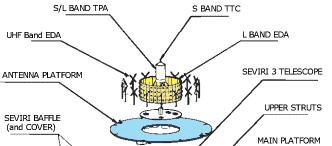
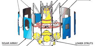
11 The MSG Satellite
12 MSG Scanning Concept


13 Possible MSG HRV Scan Patterns 1 December - 31 May 1 June - 30 November
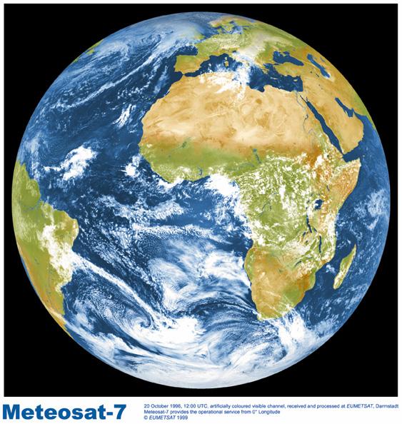
14 MSG IMAGE
15 IMAGE DATA: LEVEL 1.5 IMAGE DATA Definition: Image is geometrically corrected for all perturbations introduced by the satellite (e.g. orbit, spin, attitude, s/c manoeuvres, eclipse, etc.). The image is radiometrically corrected for all irregularities (e.g. differences between detectors, non-linearity, etc.). The HEADER and TRAILER information in the image data contains all relevant information. Absolute calibration is applied. Pixels represented by 10 bits. Size: Nominal level 1.5 image size is 3712 x 3712 pixels For HRV this becomes 5568 x Coverage: Full earth disk For HRV: Part coverage in East-West (see previous slide) Access: Via the U-MARF and in near real-time via HRIT/LRIT broadcasts
16 MSG SEVIRI Channels Basic + Airmass + Hi Res Vis Missions Basic Band (µm) Airmass Band (µm) VIS WV VIS WV IR IR O IR CO IR High Res VIS 1km Sampling IR HRV km data sampling intervals at SSP, except HRV (1 km) Images each 15 minutes
17 SEVIRI IR-Channel Bands
18 SEVIRI Channels Weighting Functions
19 IMAGE DATA: UTILISATION ASPECTS (1) Channel 0.6 and 0.8 µm 1.6 µm USE Cloud detection, scene identification, cloud tracking, aerosol observation, vegetation monitoring. Heritage from AVHRR Discriminates between snow and cloud, ice and water clouds. Aerosol information. Heritage from ATSR 3.9 µm 6.2 and 7.3 µm Low cloud and fog detection, Measurement of land and sea surface temperature at night. Spectral band broadened towards higher wavelength to improve signal-to-noise ratio. Heritage from AVHRR Upper- and mid-tropospheric water vapour, Cloud and water vapour tracking, Height allocation of semitransparent clouds 8.7 µm Quantitative information of thin cirrus clouds, Discriminates between ice and water clouds. Heritage from HIRS
20 IMAGE DATA: UTILISATION ASPECTS (2) Channel 9.7 µm USE Ozone radiances as input to NWP. Experimental channel used for tracking ozone patterns representative of wind motion in the lower stratosphere. Monitoring of evolution of total ozone field 10.8 and 12.0 µm 13.4 µm Measurement of earth surface and cloud top temperatures, Detection of cirrus and inference of total precipitable WV over sea. Split window channels from AVHRR Improvement of height determination of transmissive cirrus clouds, Temperature information from lower troposphere (cloud free areas) for instability assessment. Known from GOES VAS instrument.
21 METEOSAT SECOND GENERATION Overview 4 The MSG Ground Segment
22 MSG Ground Segment Networked configuration from the year 2002: Primary Ground Station under EUMETSAT control (Usingen, Germany) Back-up and Ranging Ground Station (Canary Islands, Spain) Acquisition of foreign satellite data Mission Control Centre at the EUMETSAT HQ (Darmstadt, Germany) Satellite Applications Facilities


23 The MSG Ground Station Located at Usingen, Germany
24 MSG MPEF MPEF is part of the Application Ground Segment (AGS) and constitutes, with the Satellite Application Facilities (SAF), the source of the Meteorological Products provided by the MSG system List of products to be extracted from Level 1.5 image data in the AGS has been agreed by EUMETSAT Member States As general principle, MPEF will generate products on a synoptic scale (better than 100 km) Important driver for the MPEF design and development Evolution of the MPEF algorithms and products Flexibility to add new algorithms and products ("plug-in approach")
25 MSG MPEF Products Baseline Atmospheric Motion Vectors (AMV) (IR 10.8, WV 6.2, WV 7.3, VIS 0.6) Calibration Monitoring (CAL-MON) Clear Sky Radiance (CSR) Climate Data Set (CDS) Cloud Analysis (CLA) Cloud Top Height (CTH) Global Instability (GI)* ISCCP Data Set (IDS) GPCP Precipitation Index (PI) Total Ozone (TOZ)* Tropospheric Humidity (THU) * GI + TOZ: product development by SAF and extraction by MPEF Meteorological Products proposed as baseline for the MSG MPEF development
26 The Satellite Application Facilities (SAF) In addition to the centralised Meteorological Product Extraction Facility in the EUMETSAT Headquarter in Darmstadt a Network of seven Satellite Application Facilities is under Development with the Objective to: Derive additional Products and Services Meet EUMETSAT requirements Located at National Meteorological Services User oriented network nodes
27 MSG Overview Conclusions Objectives MSG provides continuity of key observations of the Earth/Atmosphere system from the geostationary orbit Nominal MSG operations period of at least 12 years Spin stabilised satellite with 12 channel radiometer for operational meteorology climatology Application ground segment composed of MSG MPEF and the SAF network is a significant contribution for an optimal exploitation of MSG data More research and development effort required to optimise the use of MSG data
Meteorological product extraction: Making use of MSG imagery
 Meteorological product extraction: Making use of MSG imagery Kenneth Holmlund, Simon Elliott, Leo van de Berg, Stephen Tjemkes* Meteorological Operations Division *Meteorological Division EUMETSAT Am Kavalleriesand
EUMETSAT PLANS. Dr. K. Dieter Klaes EUMETSAT Am Kavalleriesand 31 D Darmstadt Germany
 EUMETSAT PLANS Dr. K. Dieter Klaes EUMETSAT Am Kavalleriesand 31 D-64295 Darmstadt Germany Page 1 EUMETSAT SATELLITE PROGRAMMES 96 97 98 99 00 01 02 03 04 05 06 07 08 09 10 11 12 13 14 15 16 17 18 METEOSAT
THE ATMOSPHERIC MOTION VECTOR RETRIEVAL SCHEME FOR METEOSAT SECOND GENERATION. Kenneth Holmlund. EUMETSAT Am Kavalleriesand Darmstadt Germany
 THE ATMOSPHERIC MOTION VECTOR RETRIEVAL SCHEME FOR METEOSAT SECOND GENERATION Kenneth Holmlund EUMETSAT Am Kavalleriesand 31 64293 Darmstadt Germany ABSTRACT The advent of the Meteosat Second Generation
EUMETSAT PLANS. K. Dieter Klaes EUMETSAT Darmstadt, Germany
 EUMETSAT PLANS K. Dieter Klaes EUMETSAT Darmstadt, Germany 1. INTRODUCTION The European Organisation for the Exploitation of Meteorological Satellites (EUMETSAT), contributes to the World Weather Watch
EUMETSAT current and future plans on product generation and dissemination
 EUMETSAT current and future plans on product generation and dissemination Ken Holmlund holmlund@eumetsat.de EUMETSAT SATELLITE PROGRAMMES METEOSAT 0 Service IODC Rapid Scan MSG MSG-1 MSG-2 MSG-3 MSG-4
AN INTRODUCTION TO METEOSAT SECOND GENERATION (MSG)
") AN INTRODUCTION TO METEOSAT SECOND GENERATION (MSG) BY JOHANNES SCHMETZ, PAOLO PILI, STEPHEN TJEMKES, DIETER JUST, JOCHEN KERKMANN, SERGIO ROTA, AND ALAIN RATIER Meteosat Second Generation (MSG), the new
AN INTRODUCTION TO METEOSAT SECOND GENERATION (MSG) BY JOHANNES SCHMETZ, PAOLO PILI, STEPHEN TJEMKES, DIETER JUST, JOCHEN KERKMANN, SERGIO ROTA, AND ALAIN RATIER Meteosat Second Generation (MSG), the new
Meteosat Second Generation. System Overview EUM TD 07
 Meteosat Second Generation EUM TD 07 METEOSAT SECOND GENERATION MSG EUM TD 07 Issue 1.1 EUM TD 07 Issue 1.1, 25 May 2001 Document Change Record Issue Date Change Issue 1.0 18 April 2001 Initial Issue
The In-Orbit Commissioning of MSG-1
 Earth Observation The In-Orbit Commissioning of MSG-1 MSG Project Team, Earth Observation Projects Department, ESA Directorate of Earth Observation, ESTEC, Noordwijk, The Netherlands 80 esa bulletin 114
METEOSAT THIRD GENERATION
 METEOSAT THIRD GENERATION FACTS AND FIGURES MONITORING WEATHER AND CLIMATE FROM SPACE A HIGHLY INNOVATIVE GEOSTATIONARY SATELLITE SYSTEM FOR EUROPE AND AFRICA The Meteosat Third Generation (MTG) system
6.3 METEOSAT SECOND GENERATION (MSG): CAPABILITIES AND APPLICATIONS
: CAPABILITIES AND APPLICATIONS") 6.3 METEOSAT SECOND GENERATION (MSG): CAPABILITIES AND APPLICATIONS Johannes Schmetz, Paolo Pili, Alain Ratier, Sergio Rota and Stephen Tjemkes EUMETSAT, Am Kavalleriesand 31, D-64295 Darmstadt, Germany
6.3 METEOSAT SECOND GENERATION (MSG): CAPABILITIES AND APPLICATIONS Johannes Schmetz, Paolo Pili, Alain Ratier, Sergio Rota and Stephen Tjemkes EUMETSAT, Am Kavalleriesand 31, D-64295 Darmstadt, Germany
MSG Indian Ocean Data Coverage (IODC) Jochen Grandell & Sauli Joro
 Jochen Grandell & Sauli Joro") MSG Indian Ocean Data Coverage (IODC) Jochen Grandell & Sauli Joro 1 EUM/STG-SWG/42/17/VWG/03 v1, 7 8 Mach 2017 Topics Introduction MSG-IODC Overall Project Schedule Status Product validation Products
MSG Indian Ocean Data Coverage (IODC) Jochen Grandell & Sauli Joro 1 EUM/STG-SWG/42/17/VWG/03 v1, 7 8 Mach 2017 Topics Introduction MSG-IODC Overall Project Schedule Status Product validation Products
Meteosat Third Generation (MTG): Lightning Imager and its products Jochen Grandell
: Lightning Imager and its products Jochen Grandell") 1 Go to View menu and click on Slide Master to update this footer. Include DM reference, version number and date Meteosat Third Generation (MTG): Lightning Imager and its products Jochen Grandell Topics
1 Go to View menu and click on Slide Master to update this footer. Include DM reference, version number and date Meteosat Third Generation (MTG): Lightning Imager and its products Jochen Grandell Topics
EUMETSAT SAF NETWORK. Lothar Schüller, EUMETSAT SAF Network Manager
 1 EUMETSAT SAF NETWORK Lothar Schüller, EUMETSAT SAF Network Manager EUMETSAT ground segment overview METEOSAT JASON-2 INITIAL JOINT POLAR SYSTEM METOP NOAA SATELLITES CONTROL AND DATA ACQUISITION FLIGHT
Atmospheric Motion Vectors: Product Guide
 Atmospheric Motion Vectors: Product Guide Doc.No. Issue : : EUM/TSS/MAN/14/786435 v1a EUMETSAT Eumetsat-Allee 1, D-64295 Darmstadt, Germany Tel: +49 6151 807-7 Fax: +49 6151 807 555 Date : 9 April 2015
STATUS OF JAPANESE METEOROLOGICAL SATELLITES AND RECENT ACTIVITIES OF MSC
 STATUS OF JAPANESE METEOROLOGICAL SATELLITES AND RECENT ACTIVITIES OF MSC Daisaku Uesawa Meteorological Satellite Center, Japan Meteorological Agency Abstract MTSAT-1R is the current operational Japanese
1.3 THE EUMETSAT GEOSTATIONARY AND POLAR SATELLITE SYSTEMS AND PRODUCTS. Kenneth Holmlund and Marianne König EUMETSAT
 1.3 THE EUMETSAT GEOSTATIONARY AND POLAR SATELLITE SYSTEMS AND PRODUCTS Kenneth Holmlund and Marianne König EUMETSAT 1. INTRODUCTION Satellite data are the main source of information in Numerical Weather
EUMETSAT SAF NETWORK. Lothar Schüller, EUMETSAT SAF Network Manager
 1 EUMETSAT SAF NETWORK Lothar Schüller, EUMETSAT SAF Network Manager EUMETSAT ground segment overview METEOSAT JASON-2 INITIAL JOINT POLAR SYSTEM METOP NOAA SATELLITES CONTROL AND DATA ACQUISITION FLIGHT
EUMETSAT Plans. K. Dieter Klaes EUMETSAT Am Kavalleriesand 31 D Darmstadt Germany. Abstract. Introduction. Programmatic Aspects
 EUMETSAT Plans K. Dieter Klaes EUMETSAT Am Kavalleriesand 31 D-64295 Darmstadt Germany Abstract This paper provides a summary on EUMETSAT current and planned programmes. EUMETSAT is currently developing,
Preparation for Himawari 8
 Preparation for Himawari 8 Japan Meteorological Agency Meteorological Satellite Center Hidehiko MURATA ET SUP 8, WMO HQ, Geneva, 14 17 April 2014 1/18 Introduction Background The Japan Meteorological Agency
FUTURE PLAN AND RECENT ACTIVITIES FOR THE JAPANESE FOLLOW-ON GEOSTATIONARY METEOROLOGICAL SATELLITE HIMAWARI-8/9
 FUTURE PLAN AND RECENT ACTIVITIES FOR THE JAPANESE FOLLOW-ON GEOSTATIONARY METEOROLOGICAL SATELLITE HIMAWARI-8/9 Toshiyuki Kurino Japan Meteorological Agency, 1-3-4 Otemachi Chiyodaku, Tokyo 100-8122,
STATUS AND DEVELOPMENT OF OPERATIONAL METEOSAT WIND PRODUCTS. Mikael Rattenborg. EUMETSAT, Am Kavalleriesand 31, D Darmstadt, Germany ABSTRACT
 STATUS AND DEVELOPMENT OF OPERATIONAL METEOSAT WIND PRODUCTS Mikael Rattenborg EUMETSAT, Am Kavalleriesand 31, D-64295 Darmstadt, Germany ABSTRACT The Operational Meteosat Meteorological Products are produced
EUMETSAT products and services for monitoring storms - New missions, more data and more meteorological products
 EUMETSAT products and services for monitoring storms - New missions, more data and more meteorological products Jochen Grandell 1 EUM/RSP/VWG/17/921460 Outline Overview of EUMETSAT missions Current...and
ATMOSPHERIC MOTION VECTORS DERIVED FROM MSG RAPID SCANNING SERVICE DATA AT EUMETSAT
 ATMOSPHERIC MOTION VECTORS DERIVED FROM MSG RAPID SCANNING SERVICE DATA AT EUMETSAT Manuel Carranza 1, Arthur de Smet 2, Jörgen Gustafsson 2 1 GMV Aerospace and Defence S.A. at EUMETSAT, Eumetsat-Allee
Instrument Calibration Issues: Geostationary Platforms
 Instrument Calibration Issues: Geostationary Platforms Ken Holmlund EUMETSAT kenneth.holmlund@eumetsat.int Abstract The main products derived from geostationary satellite data and used in Numerical Weather
SAFNWC/MSG SEVIRI CLOUD PRODUCTS
 SAFNWC/MSG SEVIRI CLOUD PRODUCTS M. Derrien and H. Le Gléau Météo-France / DP / Centre de Météorologie Spatiale BP 147 22302 Lannion. France ABSTRACT Within the SAF in support to Nowcasting and Very Short
An Eye in the Sky EUMETSAT. Monitoring Weather, Climate and the Environment
 An Eye in the Sky EUMETSAT Monitoring Weather, Climate and the Environment Slide: 1 Hazardous Weather Slide: 2 Hazardous Weather Slide: 3 Natural Disasters set off by severe weather Slide: 4 EUMETSAT Objectives...
Applications of the SEVIRI window channels in the infrared.
 Applications of the SEVIRI window channels in the infrared jose.prieto@eumetsat.int SEVIRI CHANNELS Properties Channel Cloud Gases Application HRV 0.7 Absorption Scattering
Meteosat Second Generation A comparison of on-ground and on-flight Imaging and Radiometric Performances of SEVIRI on MSG-1
 Meteosat Second Generation A comparison of on-ground and on-flight Imaging and Radiometric Performances of SEVIRI on MSG-1 Donny M. A. Aminou, H. J. Luhmann ESA/ESTEC, Keplerlaan 1, P.O. Box 299 2200 AG
THE LAND-SAF SURFACE ALBEDO AND DOWNWELLING SHORTWAVE RADIATION FLUX PRODUCTS
 THE LAND-SAF SURFACE ALBEDO AND DOWNWELLING SHORTWAVE RADIATION FLUX PRODUCTS Bernhard Geiger, Dulce Lajas, Laurent Franchistéguy, Dominique Carrer, Jean-Louis Roujean, Siham Lanjeri, and Catherine Meurey
6 th ET SAT meeting, April 12 15, Geneva, Switzerland Satellite Programme of KMA
 6 th ET SAT meeting, April 12 15, Geneva, Switzerland Satellite Programme of KMA Korea Meteorological Administration National Meteorological Satellite Center Status of COMS COMS Heritage COM Design & Review
Cloud Top Height Product: Product Guide
 Cloud Top Height Product: Product Guide Doc.No. Issue : : EUM/TSS/MAN/14/786420 v1a EUMETSAT Eumetsat-Allee 1, D-64295 Darmstadt, Germany Tel: +49 6151 807-7 Fax: +49 6151 807 555 Date : 21 August 2015
PRECONVECTIVE SOUNDING ANALYSIS USING IASI AND MSG- SEVIRI
 PRECONVECTIVE SOUNDING ANALYSIS USING IASI AND MSG- SEVIRI Marianne König, Dieter Klaes EUMETSAT, Eumetsat-Allee 1, 64295 Darmstadt, Germany Abstract EUMETSAT operationally generates the Global Instability
EUMETSAT Satellite Programmes Use of McIDAS at EUMETSAT
 EUMETSAT Satellite Programmes Use of McIDAS at EUMETSAT Marianne König Peter Miu McIDAS Users' Group Meeting, 07-10 May 2012 Slide 1 EUMETSAT Headquarters Darmstadt McIDAS Users' Group Meeting, 07-10 May
Arctic Weather Every 10 Minutes: Design & Operation of ABI for PCW
 Arctic Weather Every 10 Minutes: Design and Operation of ABI for PCW Dr. Paul C. Griffith and Sue Wirth 31st Space Symposium, Technical Track, Colorado Springs, Colorado This document is not subject to
Meteosat Third Generation. The Future European Geostationary Meteorological Satellite
 Meteosat Third Generation The Future European Geostationary Meteorological Satellite Meteosat Third Generation Jean-Loup Bézy, Donny Aminou & Paolo Bensi Future Programmes Department, ESA Directorate of
Comparison of cloud statistics from Meteosat with regional climate model data
 Comparison of cloud statistics from Meteosat with regional climate model data R. Huckle, F. Olesen, G. Schädler Institut für Meteorologie und Klimaforschung, Forschungszentrum Karlsruhe, Germany (roger.huckle@imk.fzk.de
GENERATION OF HIMAWARI-8 AMVs USING THE FUTURE MTG AMV PROCESSOR
 GENERATION OF HIMAWARI-8 AMVs USING THE FUTURE MTG AMV PROCESSOR Manuel Carranza 1, Régis Borde 2, Masahiro Hayashi 3 1 GMV Aerospace and Defence S.A. at EUMETSAT, Eumetsat Allee 1, D-64295 Darmstadt,
NWC-SAF Satellite Application Facility in Support to Nowcasting and Very Short Range Forecasting
 NWC-SAF Satellite Application Facility in Support to Nowcasting and Very Short Range Forecasting Marianne König Slide 1 Satellite Application Facilities (SAFs) in Europe Member State Cooperating State
Himawari 8/9 data distribution/dissemination plan
 Himawari 8/9 data distribution/dissemination plan Japan Meteorological Agency (JMA) Hidehiko MURATA Himawari is the name of this flower in Japanese ET SUP 8, WMO HQ, Geneva, 14 17 April 2014 1 Outline
VWG.01 EUMETSAT Corporate Slide Collection (EUM/CIS/VWG/14/743878) Version 1, January 2014 MONITORING WEATHER AND CLIMATE FROM SPACE
 Version 1, January 2014 MONITORING WEATHER AND CLIMATE FROM SPACE") 1 VWG.01 EUMETSAT Corporate Slide Collection (EUM/CIS/VWG/14/743878) Version 1, January 2014 MONITORING WEATHER AND CLIMATE FROM SPACE Royal charter: 25/26 October 1859 From observation to decision making:
1 VWG.01 EUMETSAT Corporate Slide Collection (EUM/CIS/VWG/14/743878) Version 1, January 2014 MONITORING WEATHER AND CLIMATE FROM SPACE Royal charter: 25/26 October 1859 From observation to decision making:
APPLICATIONS WITH METEOROLOGICAL SATELLITES. W. Paul Menzel. Office of Research and Applications NOAA/NESDIS University of Wisconsin Madison, WI
 APPLICATIONS WITH METEOROLOGICAL SATELLITES by W. Paul Menzel Office of Research and Applications NOAA/NESDIS University of Wisconsin Madison, WI July 2004 Unpublished Work Copyright Pending TABLE OF CONTENTS
CGMS Baseline. Sustained contributions to the Global Observing System. Endorsed by CGMS-46 in Bengaluru, June 2018
 CGMS Baseline Sustained contributions to the Global Observing System Best Practices for Achieving User Readiness for New Meteorological Satellites Endorsed by CGMS-46 in Bengaluru, June 2018 CGMS/DOC/18/1028862,
REVISION OF THE STATEMENT OF GUIDANCE FOR GLOBAL NUMERICAL WEATHER PREDICTION. (Submitted by Dr. J. Eyre)
") WORLD METEOROLOGICAL ORGANIZATION Distr.: RESTRICTED CBS/OPAG-IOS (ODRRGOS-5)/Doc.5, Add.5 (11.VI.2002) COMMISSION FOR BASIC SYSTEMS OPEN PROGRAMME AREA GROUP ON INTEGRATED OBSERVING SYSTEMS ITEM: 4 EXPERT
WORLD METEOROLOGICAL ORGANIZATION Distr.: RESTRICTED CBS/OPAG-IOS (ODRRGOS-5)/Doc.5, Add.5 (11.VI.2002) COMMISSION FOR BASIC SYSTEMS OPEN PROGRAMME AREA GROUP ON INTEGRATED OBSERVING SYSTEMS ITEM: 4 EXPERT
OPERATIONAL USE OF METEOSAT-8 SEVIRI DATA AND DERIVED NOWCASTING PRODUCTS. Nataša Strelec Mahović
 OPERATIONAL USE OF METEOSAT-8 SEVIRI DATA AND DERIVED NOWCASTING PRODUCTS Nataša Strelec Mahović Meteorological and Hydrological Service Grič 3, 10 000 Zagreb, Croatia strelec@cirus.dhz.hr ABSTRACT Meteosat-8
REPORT ON EUMETCAST INCLUDING GEONETCAST
 Prepared by EUMETSAT Agenda Item: F.2 Discussed in Plenary REPORT ON EUMETCAST INCLUDING GEONETCAST This paper presents the actual status of the system architecture, data services supported, and registration
Saharan Dust Longwave Radiative Forcing using GERB and SEVIRI
 Imperial College London Saharan Dust Longwave Radiative Forcing using GERB and SEVIRI Vincent Gimbert 1, H.E. Brindley 1, Nicolas Clerbaux 2, J.E. Harries 1 1. Blackett Laboratory, Imperial College, London
Satellite observation of atmospheric dust
 Satellite observation of atmospheric dust Taichu Y. Tanaka Meteorological Research Institute, Japan Meteorological Agency 11 April 2017, SDS WAS: Dust observation and modeling @WMO, Geneva Dust observations
Next generation of EUMETSAT microwave imagers and sounders: new opportunities for cloud and precipitation retrieval
 Next generation of EUMETSAT microwave imagers and sounders: new opportunities for cloud and precipitation retrieval Christophe Accadia, Sabatino Di Michele, Vinia Mattioli, Jörg Ackermann, Sreerekha Thonipparambil,
Dissemination of global products from Metop
 Dissemination of global products from Metop Simon S. Elliott EUMETSAT Operations Department, Darmstadt, Germany Introduction From an early stage in the commissioning of Metop, EUMETSAT will distribute
Dissemination of Global Products from EUMETSAT
 Dissemination of Global Products from EUMETSAT Simon Elliott EUMETSAT simon.elliott@eumetsat.int Beijing, 23 May - 1 June 2005 Slide 1 Overview NRT Replaced by EUMETCast What is EUMETCast? Which data sets
Lecture 4b: Meteorological Satellites and Instruments. Acknowledgement: Dr. S. Kidder at Colorado State Univ.
 Lecture 4b: Meteorological Satellites and Instruments Acknowledgement: Dr. S. Kidder at Colorado State Univ. US Geostationary satellites - GOES (Geostationary Operational Environmental Satellites) US
SATELLITE MONITORING OF THE CONVECTIVE STORMS
 SATELLITE MONITORING OF THE CONVECTIVE STORMS FORECASTERS POINT OF VIEW Michaela Valachová, EUMETSAT Workshop at ECMWF User Meeting Reading, 13 June 2017 Central Forecasting Office, Prague michaela.valachova@chmi.cz
INDIAN OCEAN DATA COVERAGE (IODC) - CGMS ROADMAP
 - CGMS ROADMAP") Prepared by EUMETSAT Agenda Item: 2.3 WGIII/2.3 and Plenary G.4.2 Discussed in WGIII and Plenary INDIAN OCEAN DATA COVERAGE (IODC) - CGMS ROADMAP In response to CGMS actions/recommendations: EUM WGIII/2.2
Prepared by EUMETSAT Agenda Item: 2.3 WGIII/2.3 and Plenary G.4.2 Discussed in WGIII and Plenary INDIAN OCEAN DATA COVERAGE (IODC) - CGMS ROADMAP In response to CGMS actions/recommendations: EUM WGIII/2.2
Programmatic Aspects. Low Earth Observation Systems. EUMETSAT Polar System (EPS)
") geostationary meteorological satellite system (Meteosat first generation under the Meteosat Transition Programme (MTP), and the Meteosat Second Generation (MSG)). The EUMETSAT Polar System (EPS) is EUMETSAT
geostationary meteorological satellite system (Meteosat first generation under the Meteosat Transition Programme (MTP), and the Meteosat Second Generation (MSG)). The EUMETSAT Polar System (EPS) is EUMETSAT
Cloud Top Height Product: Product Guide
 Cloud Top Height Product: Product Guide Doc.No. : Issue : v1c e-signed Date : 26 April 2017 WBS : EUM/TSS/MAN/14/786420 EUMETSAT Eumetsat-Allee 1, D-64295 Darmstadt, Germany Tel: +49 6151 807-7 Fax: +49
Results from the ARM Mobile Facility
 AMMA Workshop, Toulouse, November 2006 Results from the ARM Mobile Facility Background Anthony Slingo Environmental Systems Science Centre University of Reading, UK Selected results, including a major
Reprocessed Satellite Data Products for Assimilation and Validation
 Reprocessed Satellite Data Products for Assimilation and Validation Leo van de Berg, Bertrand Theodore EUMETSAT Page 1 Historical Presentation Contents Results of Eumetsat ERA-40 Activities Lessons Learned
KOREA GEOSTATIONARY SATELLITE PROGRAM : COMMUNICATION, OCEAN, AND METEOROLOGICAL SATELLITE(COMS)
") KOREA GEOSTATIONARY SATELLITE PROGRAM : COMMUNICATION, OCEAN, AND METEOROLOGICAL SATELLITE(COMS) Mi-Lim Ou, Jae-Gwang-Won, Sung-Rae Chung, Hye-Sook Lee, and Ae-Sook Suh Korea Meteorological Administration
KOREA GEOSTATIONARY SATELLITE PROGRAM : COMMUNICATION, OCEAN, AND METEOROLOGICAL SATELLITE(COMS) Mi-Lim Ou, Jae-Gwang-Won, Sung-Rae Chung, Hye-Sook Lee, and Ae-Sook Suh Korea Meteorological Administration
PRECIPITATION ESTIMATION FROM INFRARED SATELLITE IMAGERY
 PRECIPITATION ESTIMATION FROM INFRARED SATELLITE IMAGERY A.M. BRASJEN AUGUST 2014 1 2 PRECIPITATION ESTIMATION FROM INFRARED SATELLITE IMAGERY MASTER S THESIS AUGUST 2014 A.M. BRASJEN Department of Geoscience
OSI SAF SST Products and Services
 OSI SAF SST Products and Services Pierre Le Borgne Météo-France/DP/CMS (With G. Legendre, A. Marsouin, S. Péré, S. Philippe, H. Roquet) 2 Outline Satellite IR radiometric measurements From Brightness Temperatures
MONITORING WEATHER AND CLIMATE FROM SPACE
 MONITORING WEATHER AND CLIMATE FROM SPACE EUMETSAT Report on New Services Anders Meier Soerensen New X/L-band antenna, Greenland Athens: New 3.0 m L/X-band antenna New 2.4 m L/Xband antenna Installations
Introduction of the Hyperspectral Environmental Suite (HES) on GOES-R and beyond
 on GOES-R and beyond") Introduction of the Hyperspectral Environmental Suite (HES) on GOES-R and beyond Timothy J. Schmit SaTellite Applications and Research (STAR) Advanced Satellite Products Team (ASPT) Presented by Jun Li
Introduction of the Hyperspectral Environmental Suite (HES) on GOES-R and beyond Timothy J. Schmit SaTellite Applications and Research (STAR) Advanced Satellite Products Team (ASPT) Presented by Jun Li
THE EUMETSAT SATELLITE PROGRAMMES AN OVERVIEW FROM NOW TO THE FUTURE
 THE EUMETSAT SATELLITE PROGRAMMES AN OVERVIEW FROM NOW TO THE FUTURE Kenneth Holmlund EUMETSAT And many other contributors from EUMETSAT and its partners Current EUMETSAT satellite fleet METOP -A and -B
EUMETSAT Satellite Programmes Use of McIDAS at EUMETSAT
 EUMETSAT Satellite Programmes Use of McIDAS at EUMETSAT Sauli Joro Remote Sensing Expert Peter Miu Data Services Operations Engineer Slide: 1 EUMETSAT Headquarters Darmstadt Slide: 2 Location of EUMETSAT
A HIGH RESOLUTION EUROPEAN CLOUD CLIMATOLOGY FROM 15 YEARS OF NOAA/AVHRR DATA
 A HIGH RESOLUTION EUROPEAN CLOUD CLIMATOLOGY FROM 15 YEARS OF NOAA/AVHRR DATA R. Meerkötter 1, G. Gesell 2, V. Grewe 1, C. König 1, S. Lohmann 1, H. Mannstein 1 Deutsches Zentrum für Luft- und Raumfahrt
Status of EUMETSAT Current and Future Programmes
 Status of EUMETSAT Current and Future Programmes Ernst Koenemann Director Programme Development Spanish Industry Day 15 th Slide: 1 Brief Status of MSG and EPS All operational Missions are performing as
Polar winds from highly elliptical orbiting satellites: a new perspective
 Polar winds from highly elliptical orbiting satellites: a new perspective 10 th International Winds Workshop Tokyo, Japan, Feb -6, 010 L. Garand 1, N. Wagneur 1, R. Sarrazin 1, D. Santek, J. Key 1 Environment
Preparation for FY-4A. (Submitted by Xiang Fang, CMA)
") WORLD METEOROLOGICAL ORGANIZATION COMMISSION FOR BASIC SYSTEMS OPEN PROGRAMME AREA GROUP ON INTEGRATED OBSERVING SYSTEMS EXPERT TEAM ON SATELLITE UTILIZATION AND PRODUCTS ET-SUP-8/Doc. 10.3 (2.IV.2014)
WORLD METEOROLOGICAL ORGANIZATION COMMISSION FOR BASIC SYSTEMS OPEN PROGRAMME AREA GROUP ON INTEGRATED OBSERVING SYSTEMS EXPERT TEAM ON SATELLITE UTILIZATION AND PRODUCTS ET-SUP-8/Doc. 10.3 (2.IV.2014)
MSGVIEW: AN OPERATIONAL AND TRAINING TOOL TO PROCESS, ANALYZE AND VISUALIZATION OF MSG SEVIRI DATA
 MSGVIEW: AN OPERATIONAL AND TRAINING TOOL TO PROCESS, ANALYZE AND VISUALIZATION OF MSG SEVIRI DATA Aydın Gürol Ertürk Turkish State Meteorological Service, Remote Sensing Division, CC 401, Kalaba Ankara,
A satellite-based long-term Land Surface Temperature Climate Data Record
 Federal Department of Home Affairs FDHA Federal Office of Meteorology and Climatology MeteoSwiss A satellite-based long-term Land Surface Temperature Climate Data Record, Virgílio A. Bento, Frank M. Göttsche,
EARS-ATMS, EARS-CrIS and EARS-VIIRS: Three New Regional Services
 EARS-, EARS- and EARS-VIIRS: Three New Regional Services Anders Meier Soerensen, Ester Rojo, Thomas Heinemann, Michele Burla, Susanne Dieterle EUMETSAT Monitoring weather and climate from space Meteosat-7
IMPORTANCE OF SATELLITE DATA (FOR REANALYSIS AND BEYOND) Jörg Schulz EUMETSAT
 Jörg Schulz EUMETSAT") IMPORTANCE OF SATELLITE DATA (FOR REANALYSIS AND BEYOND) Jörg Schulz EUMETSAT Why satellite data for climate monitoring? Global coverage Global consistency, sometimes also temporal consistency High spatial
IMPORTANCE OF SATELLITE DATA (FOR REANALYSIS AND BEYOND) Jörg Schulz EUMETSAT Why satellite data for climate monitoring? Global coverage Global consistency, sometimes also temporal consistency High spatial
CURRENT STATUS OF OPERATIONAL WIND PRODUCT IN JMA/MSC
 Proceedings for the 13 th International Winds Workshop 27 June - 1 July 2016, Monterey, California, USA CURRENT STATUS OF OPERATIONAL WIND PRODUCT IN JMA/MSC Kazuki Shimoji and Kenichi Nonaka JMA/MSC,
EUMETSAT Data and Services for Climate Services and Research. Jörg Schulz
 EUMETSAT Data and Services for Climate Services and Research Jörg Schulz 1 WMO Workshop on Operational Space-based Weather and Climate Extremes Monitoring, WMO HQ, Geneva, Switzerland, 15-17 February 2017
The Eumetsat Polar System
 The Eumetsat Polar System A Major Step for Operational Meteorology MetOp Marc Cohen, Graeme Mason, Yves Buhler, Dany Provost, Dieter Klaes & Xavier Calbet Eumetsat Programme Development Department, Darmstadt,
ERA-CLIM2-WP3: Satellite data reprocessing and inter-calibration
 ERA-CLIM2-WP3: Satellite data reprocessing and inter-calibration Rob Roebeling, Jörg Schulz, Marie Doutriaux- Boucher, Alessio Lattanzio, Viju John, and Andrey Bogdanov Thanks to: Christian Marquardt and
EUMETSAT Satellite Status
 EUMETSAT Satellite Status Dr. K. Dieter Klaes EUMETSAT 1 ET-SAT Meeting 4-6 April 2017, WMO, Geneva, Switzerland EUMETSAT is an intergovernmental organisation with 30 Member States and 1 Cooperating State
The current status of FY-3D
 The current status of FY-3D Xiang Fang National Satellite Meteorological Center, China Meteorological Administration (NSMC/CMA) OUTLINE Overview Key instruments onboard FY-3D Products and data service
Overview of Himawari-8/9
 Overview of Himawari-8/9 Toshiyuki SAKURAI Meteorological Satellite Center (MSC) Japan Meteorological Agency (JMA) EUMeTrain Event Week on MTG-I Satellite 2016 Session2 - Himawari-8 and Data Applications
EUMETSAT Polar System (EPS)
") EUMETSAT Polar System (EPS) Synergetic Operational Earth Observations with the EPS/MetOp System Dieter Klaes EPS Programme Scientist Outline 1. Introduction 2. EPS System and Observations 3. Outlook 1.
EUMETSAT Polar System (EPS) Synergetic Operational Earth Observations with the EPS/MetOp System Dieter Klaes EPS Programme Scientist Outline 1. Introduction 2. EPS System and Observations 3. Outlook 1.
QUALITY OF MPEF DIVERGENCE PRODUCT AS A TOOL FOR VERY SHORT RANGE FORECASTING OF CONVECTION
 QUALITY OF MPEF DIVERGENCE PRODUCT AS A TOOL FOR VERY SHORT RANGE FORECASTING OF CONVECTION C.G. Georgiev 1, P. Santurette 2 1 National Institute of Meteorology and Hydrology, Bulgarian Academy of Sciences
RGB Experts and Developers Workshop - Introduction Tokyo, Japan 7-9 Nov 2017
 RGB Experts and Developers Workshop - Introduction Tokyo, Japan 7-9 Nov 2017 Workshop Objectives Review of existing RGB standards Reconfirm and extend existing standards (new multi-spectral imagers) Stimulate
Bias correction of satellite data at Météo-France
 Bias correction of satellite data at Météo-France É. Gérard, F. Rabier, D. Lacroix, P. Moll, T. Montmerle, P. Poli CNRM/GMAP 42 Avenue Coriolis, 31057 Toulouse, France 1. Introduction Bias correction at
Status report on current and future satellite systems by EUMETSAT Presented to CGMS-44, Plenary session, agenda item D.1
 Status report on current and future satellite systems by EUMETSAT Presented to CGMS-44, Plenary session, agenda item D.1 CGMS-44-EUMETSAT-WP-19.ppt, version 1 (# 859110), 8 June 2016 MISSION PLANNING YEAR...
Operational systems for SST products. Prof. Chris Merchant University of Reading UK
 Operational systems for SST products Prof. Chris Merchant University of Reading UK Classic Images from ATSR The Gulf Stream ATSR-2 Image, ƛ = 3.7µm Review the steps to get SST using a physical retrieval
Advanced Geostationary Observations for the OzEWEX Community. Leon Majewski Bureau of Meteorology
 Advanced Geostationary Observations for the OzEWEX Community Leon Majewski Bureau of Meteorology Overview Geostationary satellite missions & sensors Meteorological applications Access for OzEWEX researchers
4.1 New Generation Satellite Data and Nowcasting Products: Himawari
 4.1 New Generation Satellite Data and Nowcasting Products: Himawari SCOPE-Nowcasting-EP 18-20 September 2017 Koji Yamashita kobo.yamashita@met.kishou.go.jp Meteorological Satellite Center (MSC) Japan Meteorological
MTG imaging channels in the solar domain and 3.7 microns for retrieval of cloud and aerosol microphysical properties
 MTG imaging channels in the solar domain and 3.7 microns for retrieval of cloud and aerosol microphysical properties Bizzarro BIZZARRI, Elisa CARBONI, Francesco DI PAOLA and Gian Luigi LIBERTI Consiglio
GSCB Workshop 2009: EUMETSAT Missions
 GSCB Workshop 2009: EUMETSAT Missions Dr. Harald Rothfuss, EUMETSAT. GSCB Workshop 2007, ESRIN, Frascati, 18-19 June 2009. Slide: 1 Introduction To EUMETSAT The European Organisation for the Exploitation
eport Nataša Strelec Mahović Meteorological and Hydrological Service, Grič 3, Zagreb, Croatia EUMeTrain project Abstract
 eport Nataša Strelec Mahović Meteorological and Hydrological Service, Grič 3, Zagreb, Croatia EUMeTrain project Abstract The paper presents the concept of eport, an interface enabling the combined analysis
Applications of multi-spectral satellite data
 Applications of multi-spectral satellite data Jochen Kerkmann EUMETSAT, Satellite Meteorologist, Training Officer Adjusted by E de Coning South African Weather Service Content 1. Why should we use RGBs?
Operational Uses of Bands on the GOES-R Advanced Baseline Imager (ABI) Presented by: Kaba Bah
 Presented by: Kaba Bah") Operational Uses of Bands on the GOES-R Advanced Baseline Imager (ABI) Presented by: Kaba Bah Topics: Introduction to GOES-R & ABI ABI individual bands Use of band differences ABI derived products Conclusions
Operational Uses of Bands on the GOES-R Advanced Baseline Imager (ABI) Presented by: Kaba Bah Topics: Introduction to GOES-R & ABI ABI individual bands Use of band differences ABI derived products Conclusions
UPDATES IN THE ASSIMILATION OF GEOSTATIONARY RADIANCES AT ECMWF
 UPDATES IN THE ASSIMILATION OF GEOSTATIONARY RADIANCES AT ECMWF Carole Peubey, Tony McNally, Jean-Noël Thépaut, Sakari Uppala and Dick Dee ECMWF, UK Abstract Currently, ECMWF assimilates clear sky radiances
Evapotranspiration monitoring with Meteosat Second Generation satellites: method, products and utility in drought detection.
 Evapotranspiration monitoring with Meteosat Second Generation satellites: method, products and utility in drought detection. Nicolas Ghilain Royal Meteorological Institute Belgium EUMeTrain Event week
Recent Changes in the Derivation of Geostationary AMVs at EUMETSAT. Manuel Carranza Régis Borde Marie Doutriaux-Boucher
 Recent Changes in the Derivation of Geostationary AMVs at EUMETSAT Manuel Carranza Régis Borde Marie Doutriaux-Boucher Summary Introduction to EUMETSAT s geostationary AMVs Recent changes: Cross-Correlation
Updates on CMA FENGYUN Meteorological Satellite Programs
 Updates on CMA FENGYUN Meteorological Satellite Programs Peng ZHANG National Satellite Meteorological Center, China Meteorological Administration (NSMC/CMA) 29 Nov. - 5 Dec. 2017, Darmstadt, Germany 1.
CGMS Baseline In response to CGMS action/recommendation A45.01 HLPP reference: 1.1.8
 Prepared by WGIII Agenda Item: 7.1 Discussed in WGIII CGMS Baseline In response to CGMS action/recommendation A45.01 HLPP reference: 1.1.8 In CGMS-45, Working Group III agreed to hold a review of the CGMS
Future mission : IASI-new generation
 Future mission : IASI-new generation Signal/noise Spectral resolution Pixel size IASI IASI-NG Cathy Clerbaux What s next? IASI-NG (IASI-New Generation) IASI and IASI-NG spectrum Averaged over the
A Guide to Satellite Data Appropriate for Solar Energy Applications in Ireland
 University College Dublin Satellite Data A Guide to Satellite Data Appropriate for Solar Energy Applications in Ireland Eadaoin Doddy eadaoin.doddy@ucdconnect.ie 13 January 2017 Contents 1 Satellites 1
Back to basics: From Sputnik to Envisat, and beyond: The use of satellite measurements in weather forecasting and research: Part 1 A history
 Back to basics: From Sputnik to Envisat, and beyond: The use of satellite measurements in weather forecasting and research: Part 1 A history Roger Brugge 1 and Matthew Stuttard 2 1 NERC Data Assimilation