Lecture 19: Operational Remote Sensing in Visible, IR, and Microwave Channels
|
|
|
- Dayna Townsend
- 5 years ago
- Views:
Transcription
1 MET 4994 Remote Sensing: Radar and Satellite Meteorology MET 5994 Remote Sensing in Meteorology Lecture 19: Operational Remote Sensing in Visible, IR, and Microwave Channels
2 Before you use data from any remote sensing instrument, you should know Frequencies/Channels: visible, IR, microwave, or other Footprints on each channel: spatial resolution 3. Scanning geometry: conical or cross-track or along track 4. Measured/retrieved physical parameters 5. Data dimensions
3 When Does Scattering Matter? In general, particles that are far smaller than the wavelength will scatter only very weakly. Size Parameter: x 2 r
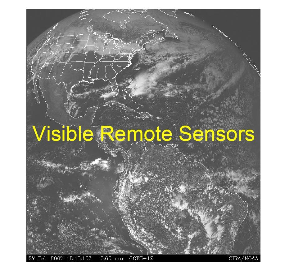
4 Spectrum: wavelengths around 0.5 µm Rain or cloud droplets are geometric or Mie scatters (r>>λ), so we use reflection/refraction to replace scattering. A cloud only a few of tens meters thick is sufficient to scatter all of the visible radiation incident on it. Absorption is negligible. Visible Channels So visible channels detect sunlight reflected by clouds and the earth's surface -- REFLECTANCE.
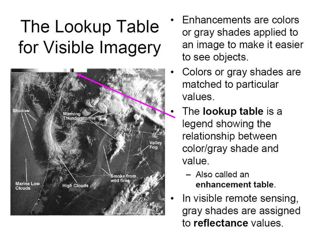
 are often semi-transparent and low clouds (Yellow) can be seen through them.")
5 Visible Image Interpretation Thick clouds (White) are bright in the visible imagery because thicker clouds generally have higher reflectance. High clouds (White) are often semi-transparent and low clouds (Yellow) can be seen through them. The land surface (Yellow) reflects sunlight less than clouds but more than the sea surface (Blue).
6 IR Channels Spectrum: usually referred as the µm window, in which the atmosphere is relatively transparent to the long-wave radiation from the Earth. IR sensors from space measure the thermal IR emission (radiation) from the Earth surface & clouds. The measured radiation can be converted to brightness temperature (T B ) using Planck s function. In IR channel, both clouds and Earth surface act as blackbody. So T B is equal to actual physical temperature. The higher the temperature of clouds or earth surface is, the stronger the measured infrared radiation. High clouds are very cold, while low clouds are much warmer. Thus, both the temperature and the height of the cloud top can be derived from the intensity of the infrared radiation.

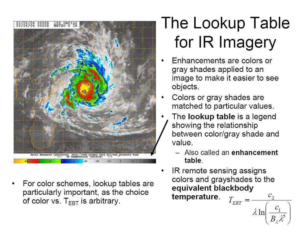
7 Absorptivity of the Atmosphere

8 Thick clouds, such as those associated with the typhoon, look white (lowest temperature). High clouds, which look semitransparent in the visible imagery, are also shown white or yellow. Low clouds are displayed as red. They may have temperatures close to that of the underlying ocean and are more difficult to identify in the infrared than in the visible imagery. The desert in Australia is much hotter (black) than any cloud and shows up clearly. IR Image Interpretation
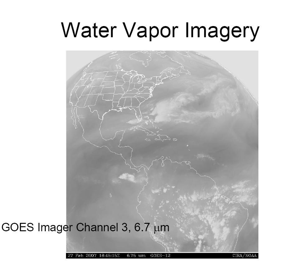
9 IR Water Vapor Channels Spectrum: water vapor absorption band around 6.7 µm. As absorption by water vapor is strong in this band, radiation from the low clouds and the earth's surface do not normally reach the satellite. The intensity of the radiation received at these channels depends on the amount of water vapor in the upper and mid-troposphere as well as the temperature of the radiation source. Water vapor image does not only represent moisture, it is proportional to the mean temperature where roughly the top 3 mm of precipitable water exists. Both moisture and temperature are important factors. The temporal changes of the humidity patterns can identify air movement and vortices even in the absence of clouds.

10 Water Vapor Image Interpretation The brighter parts show the moister parts of the upper and midtroposphere. Thick clouds and high clouds are seen white (similar to IR and visible images). The earth's surface and low clouds are undetectable. Grey shades corresponding to water vapor amounts are seen where there are no high and middle clouds. In the southern hemisphere, dark areas can be seen, associated with dry upper air. Many vortices of grey shades are also seen, associated with upper tropospheric lows.
11
12
13
14
15
16
17
18
19

20
21
22
23
24

25 TPW Skin Temperature Lifted Index CAPE
26
27


28
29
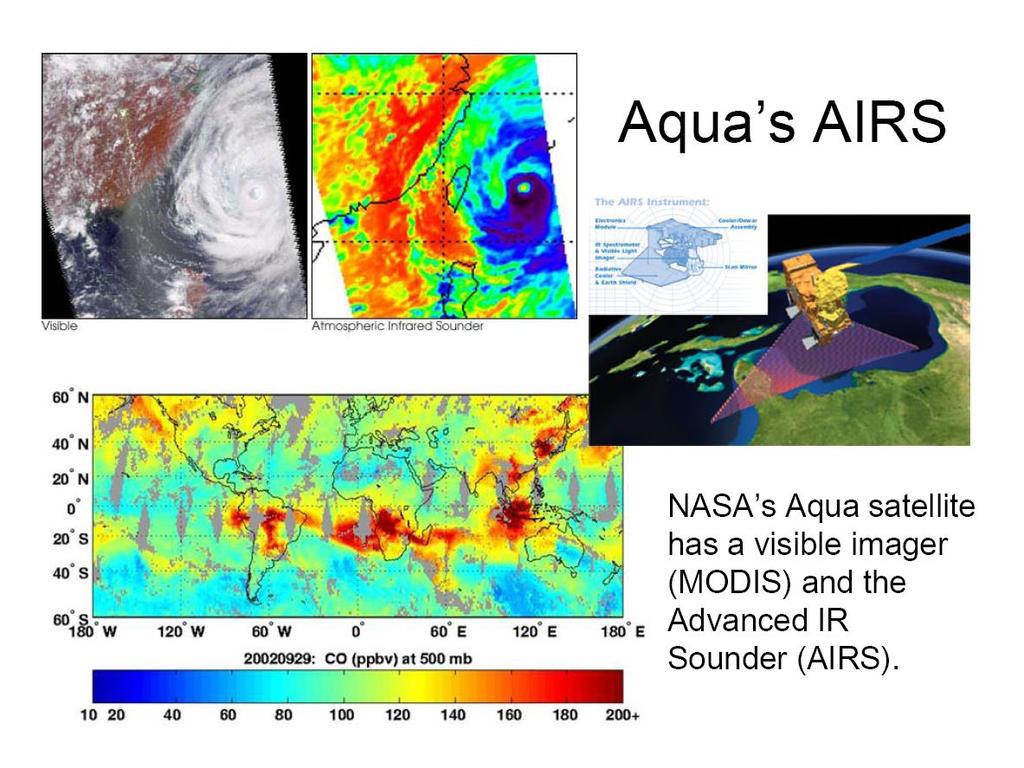
30 Satellite Imagers and Sounders Imagers: measure the horizontal field of meteorological parameter(s); no vertical information Sounders: are able to measure temperature and moisture changes with height. Sounders from the past two decades used about 20 spectral bands, while current sounders are hyperspectral, i.e., they use an order of magnitude more bands. For example, the polar-orbiting NASA Atmospheric Infrared Sounder (AIRS) uses 65 spectral radiances for temperature, 42 for water vapor, 26 for ozone, and 23 for surface temperature. Hyperspectral sounders provide profiles of about 1K/1-2km depth.
31
32 Precipitation and Convection Detection by Microwave Channels Non-raining clouds are nearly transparent (no absorption, no scattering) in microwave band, but raining clouds are not. Thus microwave is very useful to detect convection and precipitation. Passive microwave sensors detect the microwave scattering and emission signatures of liquid water or ice particles. In 10 GHz channel, ice scattering can be neglected. Only emission from rain and liquid water and background (ocean or land) is significant. The 19 and 37 GHz channels are sensitive to both emission from rain particles and scattering from ice particles. The 85 GHz and above channels are mainly sensitive to scattering from ice particles.
33 37 and 85 GHz Polarization Corrected Temperature (PCT) Unlike the infrared where convection appears cold, and the sea surface warm, in the microwave both deep convection and the sea surface can be cold. PCT (Spencer et al ) is defined by a combination of V & H brightness temperatures to remove the cold sea surface effect. In Navy Research Lab (NRL) s Tropical Cyclone satellite webpage, the 37color product is generated from the combination of 37 PCT, horizontally and vertically polarized brightness temperatures. The sea surface appears dark green, warm rain and low-level clouds appears as cyan, and deep convection appears as pink.

34 37 GHz Image Interpretation Typhoon Damrey (2000) by TRMM At 37 GHz: 1. Water clouds and precipitating clouds appear warm against a relatively cold ocean 2. Imagery resolves details missed by GHz, for example, lowlevel clouds and rain
")
 V37 (K) PR")
35 TRMM 37 GHz & 85 GHz Images for Hurricane Danielle (2004) 37 GHz Color PCT37 (K) H37 (K) PCT85 (K) V37 (K) PR Reflectivity
36 and ice water path..

37 85 GHz Image Interpretation Hurricane Gustav (2008) by AMSRE At GHz: 1. Deep convection appear relatively cold 2. Imagery can penetrate thin cirrus canopies and reveal internal storm structure 3. Imagery is able to distinguish deep convection, but can not always see low-level circulations when associated primarily with low-level water clouds 4. Spatial resolution is higher than for imagery at lower microwave frequencies
38


39 TRMM 10, 19, 37, 85 GHz: Hurricane Isabel (2003)
40
41
42
43
44

45
46
47
48 Summary of Characteristics of some Passive Microwave Instruments Spectral bands Horizontal Resolution (at nadir) Swath Width SSM/I AMSU-B TRMM TMI 19, 22, 37, 85 GHz km 89, 150, and three at ~ 183 GHz 10.7, 19, 22, 37, 85 GHz 16.3km 4.6 x 6.95 km at 85.5 GHz to 45 km at 10.7 GHz AMSR-E 6.9, 10.7, 18.7, 23.8, 36.5, 89 GHz 6 x 4km at 89GHz to 74 x 43 km at 6.9GHz 1400km 2343 km 780 km 1440 km
49 Precipitation Retrieval from Satellite Observations

50 Rainfall Retrieval from IR IR cloud top temperatures are averaged over various areas and times. Those averages are then compared with rain-gauge precipitation measurements to arrive at an operational temperature-precipitation correlation. One example of this is the GOES Precipitation Index (GPI). Advantage: High temporal resolution Disadvantage: Clouds with high cloud top temperature is not necessarily clouds producing heavy rainfall.
51 Rainfall Retrieval from Passive Microwave: Emission-based Emission-based algorthms are based on 10 & 19-GHz or lower channels. Advantage: Nearly linear relationship up to 50 mm/h without saturation at 10 GHz McGaughey et al Disadvantages: 1.Low spatial resolution: 72x43 km^2 at 10GHz; 35x21 km^2 at 19 GHz; Beamfilling problem. 2. Doesn t work for over land
52 Rainfall Retrieval from Passive Microwave: Scattering-based Scattering-based algorithms use microwave observations at high frequencies (greater than 37 GHz). Advantages: 1. Higher spatial resolution; 2. works for both over land and over ocean. Disadvantage: The direct relationship is actually between Tb and total ice water instead of rain rate. Spencer et al. 1989

53 Rainfall Retrieval from TRMM Satellite Precipitation Radar TRMM PR 2A25 rain algorithm: Assuming different particle size distributions for different rain types to get Z-R relationships. Advantages: 1. Higher spatial resolution: 4~5 km; 2. 3D structure; 3. works for both over land and over ocean; 4. Generally, it s more accurate than passive microwave retrievals. Disadvantage: PR s swath is narrow: 217 km
54
55 Satellite Microwave Instrument Scan Strategies and Viewing Geometry NCAR COMET Video lecture (you need to register, it s free!): sources/navmenu.htm
NOAA/NESDIS Tropical Web Page with LEO Satellite Products and Applications for Forecasters
 NOAA/NESDIS Tropical Web Page with LEO Satellite Products and Applications for Forecasters Sheldon Kusselson National Oceanic and Atmospheric Administration (NOAA) National Environmental Satellite Data
Meteorological Satellite Image Interpretations, Part III. Acknowledgement: Dr. S. Kidder at Colorado State Univ.
 Meteorological Satellite Image Interpretations, Part III Acknowledgement: Dr. S. Kidder at Colorado State Univ. Dates EAS417 Topics Jan 30 Introduction & Matlab tutorial Feb 1 Satellite orbits & navigation
Remote Sensing in Meteorology: Satellites and Radar. AT 351 Lab 10 April 2, Remote Sensing
 Remote Sensing in Meteorology: Satellites and Radar AT 351 Lab 10 April 2, 2008 Remote Sensing Remote sensing is gathering information about something without being in physical contact with it typically
Remote Sensing of Precipitation
 Lecture Notes Prepared by Prof. J. Francis Spring 2003 Remote Sensing of Precipitation Primary reference: Chapter 9 of KVH I. Motivation -- why do we need to measure precipitation with remote sensing instruments?
Advanced Satellite Remote Sensing: Microwave Remote Sensing. August 11, 2011
 Advanced Satellite Remote Sensing: Microwave Remote Sensing FIU HRSSERP Internship August 11, 2011 What can Microwave Satellites Measure? Ocean Surface Wind Speed SeaIce Concentration, Edge, and age Precipitation
F O U N D A T I O N A L C O U R S E
 F O U N D A T I O N A L C O U R S E December 6, 2018 Satellite Foundational Course for JPSS (SatFC-J) F O U N D A T I O N A L C O U R S E Introduction to Microwave Remote Sensing (with a focus on passive
Interpretation of Polar-orbiting Satellite Observations. Atmospheric Instrumentation
 Interpretation of Polar-orbiting Satellite Observations Outline Polar-Orbiting Observations: Review of Polar-Orbiting Satellite Systems Overview of Currently Active Satellites / Sensors Overview of Sensor
Lecture 4b: Meteorological Satellites and Instruments. Acknowledgement: Dr. S. Kidder at Colorado State Univ.
 Lecture 4b: Meteorological Satellites and Instruments Acknowledgement: Dr. S. Kidder at Colorado State Univ. US Geostationary satellites - GOES (Geostationary Operational Environmental Satellites) US
P1.23 HISTOGRAM MATCHING OF ASMR-E AND TMI BRIGHTNESS TEMPERATURES
 P1.23 HISTOGRAM MATCHING OF ASMR-E AND TMI BRIGHTNESS TEMPERATURES Thomas A. Jones* and Daniel J. Cecil Department of Atmospheric Science University of Alabama in Huntsville Huntsville, AL 1. Introduction
Lecture 4: Meteorological Satellites and Instruments. Acknowledgement: Dr. S. Kidder at Colorado State Univ.
 Lecture 4: Meteorological Satellites and Instruments Acknowledgement: Dr. S. Kidder at Colorado State Univ. Homework for the Spring Break: get some tangible, preliminary results for your final project.
Day Microphysics RGB Nephanalysis in daytime. Meteorological Satellite Center, JMA
 Day Microphysics RGB Nephanalysis in daytime Meteorological Satellite Center, JMA What s Day Microphysics RGB? R : B04 (N1 0.86) Range : 0~100 [%] Gamma : 1.0 G : B07(I4 3.9) (Solar component) Range :
REVISION OF THE STATEMENT OF GUIDANCE FOR GLOBAL NUMERICAL WEATHER PREDICTION. (Submitted by Dr. J. Eyre)
") WORLD METEOROLOGICAL ORGANIZATION Distr.: RESTRICTED CBS/OPAG-IOS (ODRRGOS-5)/Doc.5, Add.5 (11.VI.2002) COMMISSION FOR BASIC SYSTEMS OPEN PROGRAMME AREA GROUP ON INTEGRATED OBSERVING SYSTEMS ITEM: 4 EXPERT
WORLD METEOROLOGICAL ORGANIZATION Distr.: RESTRICTED CBS/OPAG-IOS (ODRRGOS-5)/Doc.5, Add.5 (11.VI.2002) COMMISSION FOR BASIC SYSTEMS OPEN PROGRAMME AREA GROUP ON INTEGRATED OBSERVING SYSTEMS ITEM: 4 EXPERT
Microwave-TC intensity estimation. Ryo Oyama Meteorological Research Institute Japan Meteorological Agency
 Microwave-TC intensity estimation Ryo Oyama Meteorological Research Institute Japan Meteorological Agency Contents 1. Introduction 2. Estimation of TC Maximum Sustained Wind (MSW) using TRMM Microwave
Applications of the SEVIRI window channels in the infrared.
 Applications of the SEVIRI window channels in the infrared jose.prieto@eumetsat.int SEVIRI CHANNELS Properties Channel Cloud Gases Application HRV 0.7 Absorption Scattering
For those 5 x5 boxes that are primarily land, AE_RnGd is simply an average of AE_Rain_L2B; the ensuing discussion pertains entirely to oceanic boxes.
 AMSR-E Monthly Level-3 Rainfall Accumulations Algorithm Theoretical Basis Document Thomas T. Wilheit Department of Atmospheric Science Texas A&M University 2007 For those 5 x5 boxes that are primarily
Introduction to Electromagnetic Radiation and Radiative Transfer
 Introduction to Electromagnetic Radiation and Radiative Transfer Temperature Dice Results Visible light, infrared (IR), ultraviolet (UV), X-rays, γ-rays, microwaves, and radio are all forms of electromagnetic
Atmospheric Lidar The Atmospheric Lidar (ATLID) is a high-spectral resolution lidar and will be the first of its type to be flown in space.
 is a high-spectral resolution lidar and will be the first of its type to be flown in space.") www.esa.int EarthCARE mission instruments ESA s EarthCARE satellite payload comprises four instruments: the Atmospheric Lidar, the Cloud Profiling Radar, the Multi-Spectral Imager and the Broad-Band Radiometer.
www.esa.int EarthCARE mission instruments ESA s EarthCARE satellite payload comprises four instruments: the Atmospheric Lidar, the Cloud Profiling Radar, the Multi-Spectral Imager and the Broad-Band Radiometer.
Moisture, Clouds, and Precipitation: Clouds and Precipitation. Dr. Michael J Passow
 Moisture, Clouds, and Precipitation: Clouds and Precipitation Dr. Michael J Passow What Processes Lift Air? Clouds require three things: water vapor, a condensation nucleus, and cooling Cooling usually
Principles of Radiative Transfer Principles of Remote Sensing. Marianne König EUMETSAT
 - Principles of Radiative Transfer Principles of Remote Sensing Marianne König EUMETSAT marianne.koenig@eumetsat.int Remote Sensing All measurement processes which perform observations/measurements of
Remote sensing of ice clouds
 Remote sensing of ice clouds Carlos Jimenez LERMA, Observatoire de Paris, France GDR microondes, Paris, 09/09/2008 Outline : ice clouds and the climate system : VIS-NIR, IR, mm/sub-mm, active 3. Observing
School on Modelling Tools and Capacity Building in Climate and Public Health April Remote Sensing
 2453-5 School on Modelling Tools and Capacity Building in Climate and Public Health 15-26 April 2013 Remote Sensing CECCATO Pietro International Research Institute for Climate and Society, IRI The Earth
Satellite and Aircraft Observations of Snowfall Signature at Microwave Frequencies. Yoo-Jeong Noh and Guosheng Liu
 Satellite and Aircraft Observations of Snowfall Signature at Microwave Frequencies Yoo-Jeong Noh and Guosheng Liu Department of Meteorology, Florida State University Tallahassee, Florida, USA Corresponding
Lecture 4: Radiation Transfer
 Lecture 4: Radiation Transfer Spectrum of radiation Stefan-Boltzmann law Selective absorption and emission Reflection and scattering Remote sensing Importance of Radiation Transfer Virtually all the exchange
Temperature (T) degrees Celsius ( o C) arbitrary scale from 0 o C at melting point of ice to 100 o C at boiling point of water Also (Kelvin, K) = o C
 degrees Celsius ( o C) arbitrary scale from 0 o C at melting point of ice to 100 o C at boiling point of water Also (Kelvin, K) = o C") 1 2 3 4 Temperature (T) degrees Celsius ( o C) arbitrary scale from 0 o C at melting point of ice to 100 o C at boiling point of water Also (Kelvin, K) = o C plus 273.15 0 K is absolute zero, the minimum
1 2 3 4 Temperature (T) degrees Celsius ( o C) arbitrary scale from 0 o C at melting point of ice to 100 o C at boiling point of water Also (Kelvin, K) = o C plus 273.15 0 K is absolute zero, the minimum
URSI-F Microwave Signatures Meeting 2010, Florence, Italy, October 4 8, Thomas Meissner Lucrezia Ricciardulli Frank Wentz
 URSI-F Microwave Signatures Meeting 2010, Florence, Italy, October 4 8, 2010 Wind Measurements from Active and Passive Microwave Sensors High Winds and Winds in Rain Thomas Meissner Lucrezia Ricciardulli
Observations of Mediterranean Precipitating Systems using AMSU
 Observations of Mediterranean Precipitating Systems using AMSU Beatriz FUNATSU 1, Chantal CLAUD 1 and Jean-Pierre CHABOUREAU 2 1 Laboratoire de Meteorologie Dynamique/IPSL, Palaiseau 2 Laboratoire d Aerologie/CNRS-UPS,
Satellite data assimilation for Numerical Weather Prediction II
 Satellite data assimilation for Numerical Weather Prediction II Niels Bormann European Centre for Medium-range Weather Forecasts (ECMWF) (with contributions from Tony McNally, Jean-Noël Thépaut, Slide
PRECIPITATION ESTIMATION FROM INFRARED SATELLITE IMAGERY
 PRECIPITATION ESTIMATION FROM INFRARED SATELLITE IMAGERY A.M. BRASJEN AUGUST 2014 1 2 PRECIPITATION ESTIMATION FROM INFRARED SATELLITE IMAGERY MASTER S THESIS AUGUST 2014 A.M. BRASJEN Department of Geoscience
Severe storms over the Mediterranean Sea: A satellite and model analysis
 National Research Council of Italy Severe storms over the Mediterranean Sea: A satellite and model analysis V. Levizzani, S. Laviola, A. Malvaldi, M. M. Miglietta, and E. Cattani 6 th International Precipitation
A two-season impact study of the Navy s WindSat surface wind retrievals in the NCEP global data assimilation system
 A two-season impact study of the Navy s WindSat surface wind retrievals in the NCEP global data assimilation system Li Bi James Jung John Le Marshall 16 April 2008 Outline WindSat overview and working
THE FEASIBILITY OF EXTRACTING LOWLEVEL WIND BY TRACING LOW LEVEL MOISTURE OBSERVED IN IR IMAGERY OVER CLOUD FREE OCEAN AREA IN THE TROPICS
 THE FEASIBILITY OF EXTRACTING LOWLEVEL WIND BY TRACING LOW LEVEL MOISTURE OBSERVED IN IR IMAGERY OVER CLOUD FREE OCEAN AREA IN THE TROPICS Toshiro Ihoue and Tetsuo Nakazawa Meteorological Research Institute
On the Satellite Determination of Multilayered Multiphase Cloud Properties. Science Systems and Applications, Inc., Hampton, Virginia 2
 JP1.10 On the Satellite Determination of Multilayered Multiphase Cloud Properties Fu-Lung Chang 1 *, Patrick Minnis 2, Sunny Sun-Mack 1, Louis Nguyen 1, Yan Chen 2 1 Science Systems and Applications, Inc.,
APPENDIX 2 OVERVIEW OF THE GLOBAL PRECIPITATION MEASUREMENT (GPM) AND THE TROPICAL RAINFALL MEASURING MISSION (TRMM) 2-1
 AND THE TROPICAL RAINFALL MEASURING MISSION (TRMM) 2-1") APPENDIX 2 OVERVIEW OF THE GLOBAL PRECIPITATION MEASUREMENT (GPM) AND THE TROPICAL RAINFALL MEASURING MISSION (TRMM) 2-1 1. Introduction Precipitation is one of most important environmental parameters.
APPENDIX 2 OVERVIEW OF THE GLOBAL PRECIPITATION MEASUREMENT (GPM) AND THE TROPICAL RAINFALL MEASURING MISSION (TRMM) 2-1 1. Introduction Precipitation is one of most important environmental parameters.
Microwave Remote Sensing of Sea Ice
 Microwave Remote Sensing of Sea Ice What is Sea Ice? Passive Microwave Remote Sensing of Sea Ice Basics Sea Ice Concentration Active Microwave Remote Sensing of Sea Ice Basics Sea Ice Type Sea Ice Motion
"Cloud and Rainfall Observations using Microwave Radiometer Data and A-priori Constraints" Christian Kummerow and Fang Wang Colorado State University
 "Cloud and Rainfall Observations using Microwave Radiometer Data and A-priori Constraints" Christian Kummerow and Fang Wang Colorado State University ECMWF-JCSDA Workshop Reading, England June 16-18, 2010
Daniel J. Cecil 1 Mariana O. Felix 1 Clay B. Blankenship 2. University of Alabama - Huntsville. University Space Research Alliance
 12A.4 SEVERE STORM ENVIRONMENTS ON DIFFERENT CONTINENTS Daniel J. Cecil 1 Mariana O. Felix 1 Clay B. Blankenship 2 1 University of Alabama - Huntsville 2 University Space Research Alliance 1. INTRODUCTION
PICTURE OF THE MONTH. Satellite Imagery of Sea Surface Temperature Cooling in the Wake of Hurricane Edouard (1996)
") 2716 MONTHLY WEATHER REVIEW VOLUME 125 PICTURE OF THE MONTH Satellite Imagery of Sea Surface Temperature Cooling in the Wake of Hurricane Edouard (1996) FRANK M. MONALDO Applied Physics Laboratory, The
2716 MONTHLY WEATHER REVIEW VOLUME 125 PICTURE OF THE MONTH Satellite Imagery of Sea Surface Temperature Cooling in the Wake of Hurricane Edouard (1996) FRANK M. MONALDO Applied Physics Laboratory, The
Lecture 13. Applications of passive remote sensing: Remote sensing of precipitation and clouds.
 Lecture 13. Applications of passive remote sensing: Remote sensing of precipitation and clouds. 1. Classification of remote sensing techniques to measure precipitation. 2. Visible and infrared remote sensing
A New Microwave Snow Emissivity Model
 A New Microwave Snow Emissivity Model Fuzhong Weng 1,2 1. Joint Center for Satellite Data Assimilation 2. NOAA/NESDIS/Office of Research and Applications Banghua Yan DSTI. Inc The 13 th International TOVS
The Transition of Atmospheric Infrared Sounder Total Ozone Products to Operations
 The Transition of Atmospheric Infrared Sounder Total Ozone Products to Operations Emily Berndt 1, Bradley Zavodsky 2, Gary Jedlovec 2 1 NASA Postdoctoral Program Marshall Space Flight Center, Huntsville,
WEATHER. Review Note Cards
 WEATHER Review Note Cards Thermometer Weather instrument that measures air temperature Units include F, C, and K ESRT 13 Sling Psychrometer Weather instrument that measures relative humidity and dewpoint
Study of the Influence of Thin Cirrus Clouds on Satellite Radiances Using Raman Lidar and GOES Data
 Study of the Influence of Thin Cirrus Clouds on Satellite Radiances Using Raman Lidar and GOES Data D. N. Whiteman, D. O C. Starr, and G. Schwemmer National Aeronautics and Space Administration Goddard
All-sky assimilation of MHS and HIRS sounder radiances
 All-sky assimilation of MHS and HIRS sounder radiances Alan Geer 1, Fabrizio Baordo 2, Niels Bormann 1, Stephen English 1 1 ECMWF 2 Now at Bureau of Meteorology, Australia All-sky assimilation at ECMWF
H-SAF future developments on Convective Precipitation Retrieval
 H-SAF future developments on Convective Precipitation Retrieval Francesco Zauli 1, Daniele Biron 1, Davide Melfi 1, Antonio Vocino 1, Massimiliano Sist 2, Michele De Rosa 2, Matteo Picchiani 2, De Leonibus
Radiation and the atmosphere
 Radiation and the atmosphere Of great importance is the difference between how the atmosphere transmits, absorbs, and scatters solar and terrestrial radiation streams. The most important statement that
Module 11: Meteorology Topic 5 Content: Weather Maps Notes
 Introduction A variety of weather maps are produced by the National Weather Service and National Oceanographic Atmospheric Administration. These maps are used to help meteorologists accurately predict
ASSIMILATION OF CLOUDY AMSU-A MICROWAVE RADIANCES IN 4D-VAR 1. Stephen English, Una O Keeffe and Martin Sharpe
 ASSIMILATION OF CLOUDY AMSU-A MICROWAVE RADIANCES IN 4D-VAR 1 Stephen English, Una O Keeffe and Martin Sharpe Met Office, FitzRoy Road, Exeter, EX1 3PB Abstract The assimilation of cloud-affected satellite
1. INTRODUCTION. investigating the differences in actual cloud microphysics.
 MICROPHYSICAL PROPERTIES OF DEVELOPING VERSUS NON-DEVELOPING CLOUD CLUSTERS DURING TROPICAL CYCLOGENESIS 4B.5 Nathan D. Johnson,* William C. Conant, and Elizabeth A. Ritchie Department of Atmospheric Sciences,
Crux of AGW s Flawed Science (Wrong water-vapor feedback and missing ocean influence)
") 1 Crux of AGW s Flawed Science (Wrong water-vapor feedback and missing ocean influence) William M. Gray Professor Emeritus Colorado State University There are many flaws in the global climate models. But
1 Crux of AGW s Flawed Science (Wrong water-vapor feedback and missing ocean influence) William M. Gray Professor Emeritus Colorado State University There are many flaws in the global climate models. But
Land Surface Temperature Measurements From the Split Window Channels of the NOAA 7 Advanced Very High Resolution Radiometer John C.
 Land Surface Temperature Measurements From the Split Window Channels of the NOAA 7 Advanced Very High Resolution Radiometer John C. Price Published in the Journal of Geophysical Research, 1984 Presented
Masahiro Kazumori, Takashi Kadowaki Numerical Prediction Division Japan Meteorological Agency
 Development of an all-sky assimilation of microwave imager and sounder radiances for the Japan Meteorological Agency global numerical weather prediction system Masahiro Kazumori, Takashi Kadowaki Numerical
Go With the Flow From High to Low Investigating Isobars
 Go With the Flow From High to Low Investigating Isobars Science 10 Mrs. Purba Air Masses The air over a warm surface can be heated, causing it to rise above more dense air. The result is the formation
How to display RGB imagery by SATAID
 How to display RGB imagery by SATAID Akihiro SHIMIZU Meteorological Satellite Center (MSC), Japan Meteorological Agency (JMA) Ver. 2015110500 RGB imagery on SATAID SATAID software has a function of overlapping
Fluid Circulation Review. Vocabulary. - Dark colored surfaces absorb more energy.
 Fluid Circulation Review Vocabulary Absorption - taking in energy as in radiation. For example, the ground will absorb the sun s radiation faster than the ocean water. Air pressure Albedo - Dark colored
C. Jimenez, C. Prigent, F. Aires, S. Ermida. Estellus, Paris, France Observatoire de Paris, France IPMA, Lisbon, Portugal
 All-weather land surface temperature estimates from microwave satellite observations, over several decades and real time: methodology and comparison with infrared estimates C. Jimenez, C. Prigent, F. Aires,
A NEW METHOD OF RETRIEVAL OF WIND VELOCITY OVER THE SEA SURFACE IN TROPICAL CYCLONES OVER THE DATA OF MICROWAVE MEASUREMENTS. A.F.
 A NEW METHOD OF RETRIEVAL OF WIND VELOCITY OVER THE SEA SURFACE IN TROPICAL CYCLONES OVER THE DATA OF MICROWAVE MEASUREMENTS A.F. Nerushev Institute of Experimental Meteorology. 82 Lenin Ave., Obninsk,
Assimilation of precipitation-related observations into global NWP models
 Assimilation of precipitation-related observations into global NWP models Alan Geer, Katrin Lonitz, Philippe Lopez, Fabrizio Baordo, Niels Bormann, Peter Lean, Stephen English Slide 1 H-SAF workshop 4
Snowfall Detection and Retrieval from Passive Microwave Satellite Observations. Guosheng Liu Florida State University
 Snowfall Detection and Retrieval from Passive Microwave Satellite Observations Guosheng Liu Florida State University Collaborators: Eun Kyoung Seo, Yalei You Snowfall Retrieval: Active vs. Passive CloudSat
Day Snow-Fog RGB Detection of low-level clouds and snow/ice covered area
 JMA Day Snow-Fog RGB Detection of low-level clouds and snow/ice covered area Meteorological Satellite Center, JMA What s Day Snow-Fog RGB? R : B04 (N1 0.86) Range : 0~100 [%] Gamma : 1.7 G : B05 (N2 1.6)
Recent improvements in the all-sky assimilation of microwave radiances at the ECMWF
 Recent improvements in the all-sky assimilation of microwave radiances at the ECMWF Katrin Lonitz, Alan Geer and many more katrin.lonitz@ecmwf.int ECMWF January 30, 2018 clear sky assimilation all-sky
Myung-Sook Park, Russell L. Elsberry and Michael M. Bell. Department of Meteorology, Naval Postgraduate School, Monterey, California, USA
 Latent heating rate profiles at different tropical cyclone stages during 2008 Tropical Cyclone Structure experiment: Comparison of ELDORA and TRMM PR retrievals Myung-Sook Park, Russell L. Elsberry and
NWP SAF. Quantitative precipitation estimation from satellite data. Satellite Application Facility for Numerical Weather Prediction
 NWP SAF Satellite Application Facility for Numerical Weather Prediction Document NWPSAF-MO-VS-011 Version 1.0 15 April 2006 Quantitative precipitation estimation from satellite data Sante Laviola University
Differences between East and West Pacific Rainfall Systems
 15 DECEMBER 2002 BERG ET AL. 3659 Differences between East and West Pacific Rainfall Systems WESLEY BERG, CHRISTIAN KUMMEROW, AND CARLOS A. MORALES Department of Atmospheric Science, Colorado State University,
Significant cyclone activity occurs in the Mediterranean
 TRMM and Lightning Observations of a Low-Pressure System over the Eastern Mediterranean BY K. LAGOUVARDOS AND V. KOTRONI Significant cyclone activity occurs in the Mediterranean area, mainly during the
THE STATUS OF THE NOAA/NESDIS OPERATIONAL AMSU PRECIPITATION ALGORITHM
 THE STATUS OF THE NOAA/NESDIS OPERATIONAL AMSU PRECIPITATION ALGORITHM R.R. Ferraro NOAA/NESDIS Cooperative Institute for Climate Studies (CICS)/ESSIC 2207 Computer and Space Sciences Building Univerisity
Model errors in tropical cloud and precipitation revealed by the assimilation of MW imagery
 Model errors in tropical cloud and precipitation revealed by the assimilation of MW imagery Katrin Lonitz, Alan Geer, Philippe Lopez + many other colleagues 20 November 2014 Katrin Lonitz ( ) Tropical
Introduction of the Hyperspectral Environmental Suite (HES) on GOES-R and beyond
 on GOES-R and beyond") Introduction of the Hyperspectral Environmental Suite (HES) on GOES-R and beyond Timothy J. Schmit SaTellite Applications and Research (STAR) Advanced Satellite Products Team (ASPT) Presented by Jun Li
Introduction of the Hyperspectral Environmental Suite (HES) on GOES-R and beyond Timothy J. Schmit SaTellite Applications and Research (STAR) Advanced Satellite Products Team (ASPT) Presented by Jun Li
State of the art of satellite rainfall estimation
 State of the art of satellite rainfall estimation 3-year comparison over South America using gauge data, and estimates from IR, TRMM radar and passive microwave Edward J. Zipser University of Utah, USA
Satellite Radiance Data Assimilation at the Met Office
 Satellite Radiance Data Assimilation at the Met Office Ed Pavelin, Stephen English, Brett Candy, Fiona Hilton Outline Summary of satellite data used in the Met Office NWP system Processing and quality
JTWC's Use of TRMM in Typhoon Forecast Operations
 Use of TRMM in Typhoon Forecast Operations JTWC's Use of TRMM in Typhoon Forecast Operations Slide 1/24 Use of TRMM in Typhoon Forecast Operations Slide 2/24 Opening Comments The current microwave satellite
ASSIMILATION EXPERIMENTS WITH DATA FROM THREE CONICALLY SCANNING MICROWAVE INSTRUMENTS (SSMIS, AMSR-E, TMI) IN THE ECMWF SYSTEM
 IN THE ECMWF SYSTEM") ASSIMILATION EXPERIMENTS WITH DATA FROM THREE CONICALLY SCANNING MICROWAVE INSTRUMENTS (SSMIS, AMSR-E, TMI) IN THE ECMWF SYSTEM Niels Bormann 1, Graeme Kelly 1, Peter Bauer 1, and Bill Bell 2 1 ECMWF,
ASSIMILATION EXPERIMENTS WITH DATA FROM THREE CONICALLY SCANNING MICROWAVE INSTRUMENTS (SSMIS, AMSR-E, TMI) IN THE ECMWF SYSTEM Niels Bormann 1, Graeme Kelly 1, Peter Bauer 1, and Bill Bell 2 1 ECMWF,
Feel free to ask for help also, we will try our best to answer your question or at least direct you to where you can find the answer.
 Page 1 Objectives: Become familiar with online resources and image searching tools Interpret different types of satellite imagery Learn about the variety of different types of TCs Part 1: Browse available
REMOTE SENSING OF THE ATMOSPHERE AND OCEANS
 EAS 6145 SPRING 2007 REMOTE SENSING OF THE ATMOSPHERE AND OCEANS Instructor: Prof. Irina N. Sokolik office 2258, phone 404-894-6180 isokolik@eas.gatech.edu Meeting Time: Mondays: 3:05-4:25 PM Wednesdays:
A Time Lag Model to Estimate Rainfall Rate Based on GOES Data
 A Time Lag Model to Estimate Rainfall Rate Based on GOES Data Nazario D. Ramirez, Robert J. Kuligowski, and Joan M. Castro Octava Reunión Nacional de Percepción Remota y Sistemas Geográficos de Información
9A.2 Tropical Cyclone Satellite Tutorial Online Through The COMET Program
 9A.2 Tropical Cyclone Satellite Tutorial Online Through The COMET Program Thomas F. Lee Steven D. Miller F. Joseph Turk Jeffrey D. Hawkins Naval Research Laboratory, Monterey CA Patrick Dills Sherwood
Spectrum of Radiation. Importance of Radiation Transfer. Radiation Intensity and Wavelength. Lecture 3: Atmospheric Radiative Transfer and Climate
 Lecture 3: Atmospheric Radiative Transfer and Climate Radiation Intensity and Wavelength frequency Planck s constant Solar and infrared radiation selective absorption and emission Selective absorption
Remote Sensing. RAHS C Division Invitational
 Remote Sensing RAHS C Division Invitational 2017-18 Instructions: Answer all questions on this answer sheet. Sheets may be double sided, check both sides! If you separate the sheets of the test be sure
Outline of 4 Lectures
 Outline of 4 Lectures 1. Sept. 17, 2008: TC best track definition and datasets, global distribution of TCs; Review of history of meteorological satellites, introducing different orbits, scanning patterns,
Rain rate retrieval using the 183-WSL algorithm
 Rain rate retrieval using the 183-WSL algorithm S. Laviola, and V. Levizzani Institute of Atmospheric Sciences and Climate, National Research Council Bologna, Italy (s.laviola@isac.cnr.it) ABSTRACT High
Sensitivity Study of the MODIS Cloud Top Property
 Sensitivity Study of the MODIS Cloud Top Property Algorithm to CO 2 Spectral Response Functions Hong Zhang a*, Richard Frey a and Paul Menzel b a Cooperative Institute for Meteorological Satellite Studies,
Characteristics of Global Precipitable Water Revealed by COSMIC Measurements
 Characteristics of Global Precipitable Water Revealed by COSMIC Measurements Ching-Yuang Huang 1,2, Wen-Hsin Teng 1, Shu-Peng Ho 3, Ying-Hwa Kuo 3, and Xin-Jia Zhou 3 1 Department of Atmospheric Sciences,
Lecture 3: Atmospheric Radiative Transfer and Climate
 Lecture 3: Atmospheric Radiative Transfer and Climate Solar and infrared radiation selective absorption and emission Selective absorption and emission Cloud and radiation Radiative-convective equilibrium
Topics: Visible & Infrared Measurement Principal Radiation and the Planck Function Infrared Radiative Transfer Equation
 Review of Remote Sensing Fundamentals Allen Huang Cooperative Institute for Meteorological Satellite Studies Space Science & Engineering Center University of Wisconsin-Madison, USA Topics: Visible & Infrared
PRECONVECTIVE SOUNDING ANALYSIS USING IASI AND MSG- SEVIRI
 PRECONVECTIVE SOUNDING ANALYSIS USING IASI AND MSG- SEVIRI Marianne König, Dieter Klaes EUMETSAT, Eumetsat-Allee 1, 64295 Darmstadt, Germany Abstract EUMETSAT operationally generates the Global Instability
Operational Uses of Bands on the GOES-R Advanced Baseline Imager (ABI) Presented by: Kaba Bah
 Presented by: Kaba Bah") Operational Uses of Bands on the GOES-R Advanced Baseline Imager (ABI) Presented by: Kaba Bah Topics: Introduction to GOES-R & ABI ABI individual bands Use of band differences ABI derived products Conclusions
Operational Uses of Bands on the GOES-R Advanced Baseline Imager (ABI) Presented by: Kaba Bah Topics: Introduction to GOES-R & ABI ABI individual bands Use of band differences ABI derived products Conclusions
Meteorology. I. The Atmosphere - the thin envelope of gas that surrounds the earth.
 Meteorology I. The Atmosphere - the thin envelope of gas that surrounds the earth. A. Atmospheric Structure - the atmosphere is divided into five distinct layers that are based on their unique characteristics.
Lecture 3: Global Energy Cycle
 Lecture 3: Global Energy Cycle Planetary energy balance Greenhouse Effect Vertical energy balance Latitudinal energy balance Seasonal and diurnal cycles Solar Flux and Flux Density Solar Luminosity (L)
Observations of Indian Ocean tropical cyclones by 85 GHz channel of TRMM Microwave Imager (TMI)
") Observations of Indian Ocean tropical cyclones by 85 GHz channel of TRMM Microwave Imager (TMI) C.M.KISHTAWAL, FALGUNI PATADIA, and P.C.JOSHI Atmospheric Sciences Division, Meteorology and Oceanography
Observations of Indian Ocean tropical cyclones by 85 GHz channel of TRMM Microwave Imager (TMI) C.M.KISHTAWAL, FALGUNI PATADIA, and P.C.JOSHI Atmospheric Sciences Division, Meteorology and Oceanography
8.2 Numerical Study of Relationships between Convective Vertical Velocity, Radar Reflectivity Profiles, and Passive Microwave Brightness Temperatures
 8.2 Numerical Study of Relationships between Convective Vertical Velocity, Radar Reflectivity Profiles, and Passive Microwave Brightness Temperatures Yaping Li, Edward J. Zipser, Steven K. Krueger, and
SNOWFALL RATE RETRIEVAL USING AMSU/MHS PASSIVE MICROWAVE DATA
 SNOWFALL RATE RETRIEVAL USING AMSU/MHS PASSIVE MICROWAVE DATA Huan Meng 1, Ralph Ferraro 1, Banghua Yan 2 1 NOAA/NESDIS/STAR, 5200 Auth Road Room 701, Camp Spring, MD, USA 20746 2 Perot Systems Government
For the operational forecaster one important precondition for the diagnosis and prediction of
 Initiation of Deep Moist Convection at WV-Boundaries Vienna, Austria For the operational forecaster one important precondition for the diagnosis and prediction of convective activity is the availability
PARCWAPT Passive Radiometry Cloud Water Profiling Technique
 PARCWAPT Passive Radiometry Cloud Water Profiling Technique By: H. Czekala, T. Rose, Radiometer Physics GmbH, Germany A new cloud liquid water profiling technique by Radiometer Physics GmbH (patent pending)
Hyperspectral Microwave Atmospheric Sounding
 Hyperspectral Microwave Atmospheric Sounding W. J. Blackwell, L. J. Bickmeier, R. V. Leslie, M. L. Pieper, J. E. Samra, and C. Surussavadee 1 April 14, 2010 ITSC-17 This work is sponsored by the Department
McIDAS support of Suomi-NPP /JPSS and GOES-R L2
 McIDAS support of Suomi-NPP /JPSS and GOES-R L2 William Straka III 1 Tommy Jasmin 1, Bob Carp 1 1 Cooperative Institute for Meteorological Satellite Studies, Space Science and Engineering Center, University
Assimilation of satellite derived soil moisture for weather forecasting
 Assimilation of satellite derived soil moisture for weather forecasting www.cawcr.gov.au Imtiaz Dharssi and Peter Steinle February 2011 SMOS/SMAP workshop, Monash University Summary In preparation of the
Eight Years of TRMM Data: Understanding Regional Mechanisms Behind the Diurnal Cycle
 Eight Years of TRMM Data: Understanding Regional Mechanisms Behind the Diurnal Cycle Steve Nesbitt, Rob Cifelli, Steve Rutledge Colorado State University Chuntao Liu, Ed Zipser University of Utah Funding
ECNU WORKSHOP LAB ONE 2011/05/25)
") ECNU WORKSHOP LAB ONE (Liam.Gumley@ssec.wisc.edu 2011/05/25) The objective of this laboratory exercise is to become familiar with the characteristics of MODIS Level 1B 1000 meter resolution data. After
ECNU WORKSHOP LAB ONE (Liam.Gumley@ssec.wisc.edu 2011/05/25) The objective of this laboratory exercise is to become familiar with the characteristics of MODIS Level 1B 1000 meter resolution data. After
Blackbody radiation. Main Laws. Brightness temperature. 1. Concepts of a blackbody and thermodynamical equilibrium.
 Lecture 4 lackbody radiation. Main Laws. rightness temperature. Objectives: 1. Concepts of a blackbody, thermodynamical equilibrium, and local thermodynamical equilibrium.. Main laws: lackbody emission:
Reminder: All answers MUST GO ON ANSWER SHEET! Answers recorded in the exam booklet will not count.
 Reminder: All answers MUST GO ON ANSWER SHEET! Answers recorded in the exam booklet will not count. 1. Identify the following acronyms; compare these platform types; provide situations where one platform
APPLICATIONS WITH METEOROLOGICAL SATELLITES. W. Paul Menzel. Office of Research and Applications NOAA/NESDIS University of Wisconsin Madison, WI
 APPLICATIONS WITH METEOROLOGICAL SATELLITES by W. Paul Menzel Office of Research and Applications NOAA/NESDIS University of Wisconsin Madison, WI July 2004 Unpublished Work Copyright Pending TABLE OF CONTENTS