Outline of 4 Lectures
|
|
|
- Adelia Reeves
- 5 years ago
- Views:
Transcription
1 Outline of 4 Lectures 1. Sept. 17, 2008: TC best track definition and datasets, global distribution of TCs; Review of history of meteorological satellites, introducing different orbits, scanning patterns, and space-time samplings. Also introduce the differences between the satellites and the instruments. 2. Sept. 19, 2008: Introduction of space borne instruments including visible, IR and microwave. Will briefly talk about radiative transfer theories in different channels and rainfall retrieval algorithms from IR and microwave. Problem set: Due on the 3rd lecture day 3. Oct. or Nov.?: Current status of TC intensity and rainfall forecasts. Introduction of satellite-based TC intensity and rainfall prediction techniques, including DVORAK, SHIPs, and R-CLIPER. 4. Oct. or Nov.?: Convective properties of tropical cyclones. An introduction of TRMM-based TCPF database. Climatology of tropical cyclone rainfall and its contribution to global precipitation.
2 Outline for Today (Sept. 17, 2008) 1. Best Track 2. Global Distribution of TCs 3. History of meteorological satellites 4. Different orbits, scanning patterns, and space-time samplings. 5. Differences between the satellites and the instruments.
3 What is best track? Best Track: A subjectively-smoothed representation of a tropical cyclone's location and intensity over its lifetime. The best track contains the cyclone's latitude, longitude, maximum sustained surface winds, and minimum sea-level pressure at 6-hourly intervals. Best track positions and intensities, which are based on a post-storm assessment of all available data, may differ from values contained in storm advisories. ID Name YYYYMMDDHH lat Lon MaxV MinP BOB * HR BOB * HR BOB * HR BOB * HR BOB * HR BOB * HR BOB * HR BOB * HR BOB * HR BOB * HR BOB * HR BOB * HR BOB E HR
4
5 NHC and JTWC Best Tracks --Hurricane Best Track Files (HURDAT) North Atlantic ( ) East pacific ( ) --Images of Past Tracks -- Southern Hemisphere ( ) -- Northern Indian Ocean ( ) -- Western North Pacific Ocean ( ) -- Data only -- Sorted by year and 6 basins -- Include advisory tracks as well as best track for recent years -- Include both images and data

6 Global Distribution of Tropical Cyclones TCs do not form very close to the equator and do not ever cross the equator; Northern Hemisphere: The western North Pacific is the most active tropical cyclone region. It is also the region with the largest number of intense TCs; TCs in the western North Pacific and the North Atlantic can have tracks that extend to very high latitudes. Storms following these long tracks generally undergo extratropical transition; The North Indian Ocean (Bay of Bengal and Arabian Sea) is bounded by land to the north and the eastern North Pacific is bounded by cold water to the north. These environmental features limit the lifetimes of storms in these regions. The Bay of Bengal has about five times as many TCs as the Arabian Sea. The high mountain ranges and low-lying coastal plains and river deltas of the Bay of Bengal combine to make this region extremely vulnerable to TCs. Indeed, the two most devastating TCs on record occurred in this region. Courtesy of the COMET program online text book Introduction of tropical meteorology Southern Hemisphere: Southern Hemisphere (SH) tropical cyclones are generally weaker than storms in the North Pacific and Atlantic basins; The extension of the subtropical jet into tropical latitudes in the SH acts to constrain the tracks of tropical cyclones. Even so, a few SH tropical cyclones undergo extratropical transition; Although rare, systems resembling tropical cyclones can occur in the South Atlantic Ocean and off the subtropical east coasts of Australia and southern Africa.
. NWP: TC could occur every month, but mainly during Jun. through Nov. SPA & SIO: Nov.")
7 TC season: ATL: 1 Jun 30 Nov EPA: 15 May - 30 Nov NIO: TCs tend to occur in the monsoon transition months of early (MayJune) and late in the wet season (OctoberNovember). NWP: TC could occur every month, but mainly during Jun. through Nov. SPA & SIO: Nov. - Apr.

8 TC/lanfalling TC Numbers in Each Basin NIO 44/34 SIO 150/60 NWP 219/194 SPA 88/32 EPA 133/16 ATL 137/48

9
 Webster et al. (2005): doubling of % of cat 4+5 TCs (1970-2005).")
10 Change in Numbers of Intense TC:Global Warming or Multi-Decadal Variability? Judy Curry---- So for the studies that have actually examined changes in major or cat 4+5 TCs, here is a summary of what we have: 1) Webster et al. (2005): doubling of % of cat 4+5 TCs ( ). 2) Kuleshev et al. (2008): tripling of SH TCs less than 949 mb ( ) 3) Emanuel (personal communication): 50% increase of % Cat 4+5 TCs ( ) 4) Elsner et al. (2008): 31% increase in % cat 3+ TCs per 1oC SST increase Elsber et al. (2008)
11 History of Meteorological Satellites (metsats) 1. The first satellite with a meteorological instrument: Vanguard 2, launched in Feb Supposed to get a visible Earth image. But the data were unusable because the satellite wobbled on its axis. 2. Explorer 6: the satellite with meteorological instruments launched in Aug. 1959, carried an imaging system and a Suomi radiometer. The data were unusable too. 3.The first successful meteorological instrument on an orbiting satellite was the Suomi radiometer, which flew on Explorer 7, launched Oct The Suomi radiometer was developed by Verner Suomi and colleagues at the Univ. of Wisconsin, and designed for measuring solar and infrared radiation. 4. The first satellite completedly dedicated to satellite meteorology was TIROS 1 (Television and Infrared Observational Satellite), launched in April Image-making instrument: a vidicon camera 5. TIROS series: TIROS 1-10 ( ) -- with improved meteorological instruments. 6. Nimbus series: Nimbus 1-7 ( ) An extremely important series of experimental metsats. Nimbus 1 was the first sunsynchronous satellite (passed over any point on Earth at approximately the same local time).

12 Current Global Metsat Observation System 7. Since the mid-1960s, no undetected TCs anywhere on Earth. 8. GOES 1: The first truly operational geo stationary metsat was launched in Oct
13 Different orbits, scanning patterns, and space-time samplings.
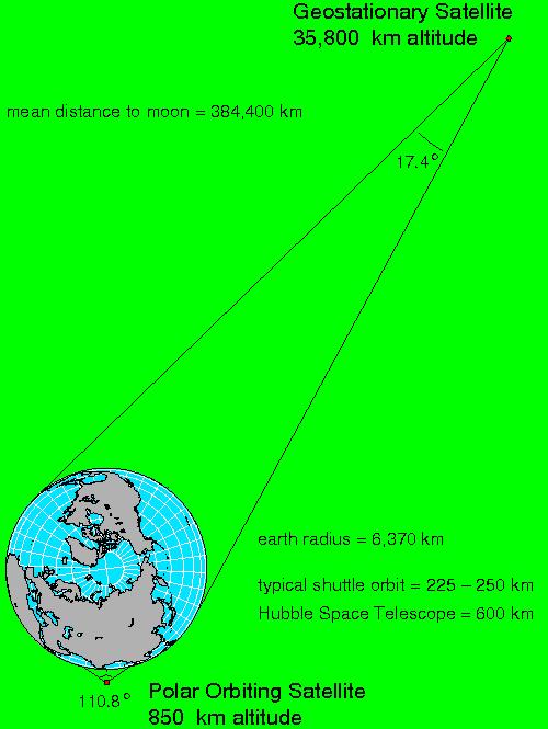
14 Satellite Orbits: 1 1. Geostationary orbits: Geostationary satellites orbit in the earth's equatorial plane at a height of 38,500 km. At this height, the satellite's orbital period matches the rotation of the Earth, so the satellite seems to stay stationary over the same point on the equator. s

15 GOES US coverage
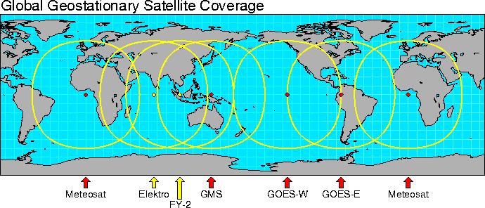

16 Geostationary Satellite Coverages
17 Facts for Geostationary Orbits 1. Continuous observation and high temporal resolution: Since the field of view of a satellite in geostationary orbit is fixed, it always views the same geographical area, day or night. This is ideal for making regular sequential observations of cloud patterns over a region with visible and infrared radiometers. High temporal resolution and constant viewing angles are the defining features of geostationary imagery. Good for diurnal variation studies. 2. Spatial resolution: Geostationary satellites sensors are most useful for tracking atmospheric features over great distances because of their high temporal resolution (15 30 minute intervals) and hemispheric field of view. However, the orbital distance of the satellites means that their spatial resolution is less than optimal for the identification of features smaller than 1km.

18 Satellite Orbits: 2 2. Sun-synchronous near-polar orbits, also referred as polar orbits: On this orbit the Metsat passes over any given point on the Earth s surface at the same local solar time. Polar-orbiting satellites are around the poles at approximately 850 km above the surface. Satellites in this category include the NOAA Polar-orbiting Operational Environmental Satellites (POES), satellites of the Defense Meteorological Satellite Program (DMSP), the European Space Agency s MetOp, National Polarorbiting Environmental Satellite System (NPOESS), A-Train constellation, QuikScat, and Global Precipitation Mission (GPM). -- Inclination angle: the highest latitude reached by the subsatellite point. About 98.7 degree for sun-synchronous orbits. -- Animation: 14 orbital tracks for a sun-synchronous satellite in near-polar orbit.: Daily coverage. ~djohnson/satellite/cover age.html


19 POES coverage of north polar regions in a half day POES coverage of south polar regions in a half day

20
21 Facts for Polar Orbits 1. Due to its shorter distance to the Earth, a polar orbiting satellite provides superior spatial resolution over a small field of view (on the order of 100 to 1000km). 2. Global coverage from a single satellite. 3. Polar orbiting satellites pass the equator at most twice a day at same local times: one is descending, the other is ascending. 4. For studies of diurnal variation, a point must be observed at local times throughout the day. Since polar orbiting satellites view a point at nearly the same two local times everyday, they are not useful for diurnal variation studies.
 -- Example: The TRMM orbit is circular and is at an altitude of")
22 Satellite Orbits: 3 2. Other orbits: research and development which orbit between certain latitudes a few hundred km above the surface (lower Earth orbits) -- Example: The TRMM orbit is circular and is at an altitude of 350 km and an inclination of 35 degrees to the Equator. TRMM flies over each position on the Earth's surface at a different local time each day. So it is good for diurnal variation studies. -- Animation of TRMM orbit
23 Satellite Instruments Instruments are sensors on board satellites. Meteorological observations are taken by instruments. For example, Instrument Satellite PR TMI SSM/I SSM/I CPR MODIS MODIS SeaWinds SeaWinds TRMM TRMM DMSP F14 DMSP F15 CloudSat Terra Aqua QuikSCAT NSCAT
24 Before you use any data from an instrument, you should know Frequencies/Channels: visible, IR, microwave, or other Footprints on each channel: spatial resolution 3. Scanning geometry: conical or cross-track or along track 4. Measured/retrieved physical parameters 5. Data dimensions
25 Satellite Instrument Scanning Geometry Animation of Satellite Instrument Scanning Geometry: 1. Conical (SSM/I, TMI, etc) 2. Cross-track (TRMM PR)
26 How to calculate the altitude of a GEOS satellite Balance between centripital force (mv^2/r) and gravity force (GMm/r^2): Angular velocity of earth: 7.3x10^-5 rad/s (=2xPI/T) Orbital constant: GM=3.986x10^14 m^3/s^2
Outline of 4 Lectures
 Outline of 4 Lectures 1. Sept. 17, 2008: TC best track definition and datasets, global distribution of TCs; Review of history of meteorological satellites, introducing different orbits, scanning patterns,
Interpretation of Polar-orbiting Satellite Observations. Atmospheric Instrumentation
 Interpretation of Polar-orbiting Satellite Observations Outline Polar-Orbiting Observations: Review of Polar-Orbiting Satellite Systems Overview of Currently Active Satellites / Sensors Overview of Sensor
Lecture 4b: Meteorological Satellites and Instruments. Acknowledgement: Dr. S. Kidder at Colorado State Univ.
 Lecture 4b: Meteorological Satellites and Instruments Acknowledgement: Dr. S. Kidder at Colorado State Univ. US Geostationary satellites - GOES (Geostationary Operational Environmental Satellites) US
APPENDIX 2 OVERVIEW OF THE GLOBAL PRECIPITATION MEASUREMENT (GPM) AND THE TROPICAL RAINFALL MEASURING MISSION (TRMM) 2-1
 AND THE TROPICAL RAINFALL MEASURING MISSION (TRMM) 2-1") APPENDIX 2 OVERVIEW OF THE GLOBAL PRECIPITATION MEASUREMENT (GPM) AND THE TROPICAL RAINFALL MEASURING MISSION (TRMM) 2-1 1. Introduction Precipitation is one of most important environmental parameters.
APPENDIX 2 OVERVIEW OF THE GLOBAL PRECIPITATION MEASUREMENT (GPM) AND THE TROPICAL RAINFALL MEASURING MISSION (TRMM) 2-1 1. Introduction Precipitation is one of most important environmental parameters.
Lecture 19: Operational Remote Sensing in Visible, IR, and Microwave Channels
 MET 4994 Remote Sensing: Radar and Satellite Meteorology MET 5994 Remote Sensing in Meteorology Lecture 19: Operational Remote Sensing in Visible, IR, and Microwave Channels Before you use data from any
Welcome and Introduction
 Welcome and Introduction Riko Oki Earth Observation Research Center (EORC) Japan Aerospace Exploration Agency (JAXA) 7th Workshop of International Precipitation Working Group 17 November 2014 Tsukuba International
Daniel J. Cecil 1 Mariana O. Felix 1 Clay B. Blankenship 2. University of Alabama - Huntsville. University Space Research Alliance
 12A.4 SEVERE STORM ENVIRONMENTS ON DIFFERENT CONTINENTS Daniel J. Cecil 1 Mariana O. Felix 1 Clay B. Blankenship 2 1 University of Alabama - Huntsville 2 University Space Research Alliance 1. INTRODUCTION
Back to basics: From Sputnik to Envisat, and beyond: The use of satellite measurements in weather forecasting and research: Part 1 A history
 Back to basics: From Sputnik to Envisat, and beyond: The use of satellite measurements in weather forecasting and research: Part 1 A history Roger Brugge 1 and Matthew Stuttard 2 1 NERC Data Assimilation
QuikSCAT Analysis of Hurricane Force Extratropical Cyclones in the Pacific Ocean
 University of Rhode Island DigitalCommons@URI Senior Honors Projects Honors Program at the University of Rhode Island 2010 QuikSCAT Analysis of Hurricane Force Extratropical Cyclones in the Pacific Ocean
Why There Is Weather?
 Lecture 6: Weather, Music Of Our Sphere Weather and Climate WEATHER The daily fluctuations in atmospheric conditions. The atmosphere on its own can produce weather. (From Understanding Weather & Climate)
Some figures courtesy of: Chris Landsea National Hurricane Center, Miami. Intergovernmental Panel on Climate Change
 Hurricanes and Global Warming Pat Fitzpatrick Mississippi State University, GeoSystems Research Institute Some figures courtesy of: Chris Landsea National Hurricane Center, Miami Intergovernmental Panel
4B.4 HURRICANE SATELLITE (HURSAT) DATA SETS: LOW EARTH ORBIT INFRARED AND MICROWAVE DATA
 DATA SETS: LOW EARTH ORBIT INFRARED AND MICROWAVE DATA") 4B.4 HURRICANE SATELLITE (HURSAT) DATA SETS: LOW EARTH ORBIT INFRARED AND MICROWAVE DATA Kenneth R. Knapp* NOAA - National Climatic Data Center, Asheville, North Carolina 1. INTRODUCTION Given the recent
4B.4 HURRICANE SATELLITE (HURSAT) DATA SETS: LOW EARTH ORBIT INFRARED AND MICROWAVE DATA Kenneth R. Knapp* NOAA - National Climatic Data Center, Asheville, North Carolina 1. INTRODUCTION Given the recent
SAN FRANCISCO STATE UNIVERSITY NAME DEPARTMENT OF GEOSCIENCES Spring 2013
 SAN FRANCISCO STATE UNIVERSITY NAME DEPARTMENT OF GEOSCIENCES Spring 2013 METR 415/715: MONTEVERDI QUIZ 1 Open Book and Open Notes 200 points, 45 minutes 1. Compute the altitude of a geostationary orbit
Lecture 1d: Satellite Orbits
 Lecture 1d: Satellite Orbits Outline 1. Newton s Laws of Motion 2. Newton s Law of Universal Gravitation 3. Kepler s Laws 4. Putting Newton and Kepler s Laws together and applying them to the Earth-satellite
Comparison of Diurnal Variation of Precipitation System Observed by TRMM PR, TMI and VIRS
 Comparison of Diurnal Variation of Precipitation System Observed by TRMM PR, TMI and VIRS Munehisa K. Yamamoto, Fumie A. Furuzawa 2,3 and Kenji Nakamura 3 : Graduate School of Environmental Studies, Nagoya
P6.13 GLOBAL AND MONTHLY DIURNAL PRECIPITATION STATISTICS BASED ON PASSIVE MICROWAVE OBSERVATIONS FROM AMSU
 P6.13 GLOBAL AND MONTHLY DIURNAL PRECIPITATION STATISTICS BASED ON PASSIVE MICROWAVE OBSERVATIONS FROM AMSU Frederick W. Chen*, David H. Staelin, and Chinnawat Surussavadee Massachusetts Institute of Technology,
4. Climatic changes. Past variability Future evolution
 4. Climatic changes Past variability Future evolution TROPICAL CYCLONES and CLIMATE How TCs have varied during recent and distant past? How will TC activity vary in the future? 2 CURRENT CLIMATE : how
International Cooperation in Operational Environmental Satellites: The U.S. Experience
 Committee on the Peaceful Uses of Outer Space Science and Technology Sub committee Forty seventh session February 17, 2010 Vienna, Austria International Cooperation in Operational Environmental Satellites:
JTWC's Use of TRMM in Typhoon Forecast Operations
 Use of TRMM in Typhoon Forecast Operations JTWC's Use of TRMM in Typhoon Forecast Operations Slide 1/24 Use of TRMM in Typhoon Forecast Operations Slide 2/24 Opening Comments The current microwave satellite
Japanese Programs on Space and Water Applications
 Japanese Programs on Space and Water Applications Tamotsu IGARASHI Remote Sensing Technology Center of Japan June 2006 COPUOS 2006 Vienna International Centre Water-related hazards/disasters may occur
A MEDIUM EARTH ORBIT CONTELLATION FOR POLAR WIND MEASUREMENTS
 A MEDIUM EARTH ORBIT CONTELLATION FOR POLAR WIND MEASUREMENTS Gerald J. Dittberner 1, Shyam N. Bajpai 1, Andrew J. Gerber, jr. 2, Richard Baron 2, Francois Rogez 2 1 U.S. National Oceanic and Atmospheric
NOAA/NESDIS Tropical Web Page with LEO Satellite Products and Applications for Forecasters
 NOAA/NESDIS Tropical Web Page with LEO Satellite Products and Applications for Forecasters Sheldon Kusselson National Oceanic and Atmospheric Administration (NOAA) National Environmental Satellite Data
Remote Sensing I: Basics
 Remote Sensing I: Basics Kelly M. Brunt Earth System Science Interdisciplinary Center, University of Maryland Cryospheric Science Laboratory, Goddard Space Flight Center kelly.m.brunt@nasa.gov (Based on
New NASA Ocean Observations and Coastal Applications
 New NASA Ocean Observations and Coastal Applications Duane Armstrong Chief, Applied Science & Technology Project Office August 20, 2014 1 Outline NASA s new Earth Science Ocean Science Missions for 2014
Remote Sensing in Meteorology: Satellites and Radar. AT 351 Lab 10 April 2, Remote Sensing
 Remote Sensing in Meteorology: Satellites and Radar AT 351 Lab 10 April 2, 2008 Remote Sensing Remote sensing is gathering information about something without being in physical contact with it typically
Overview and Access to GPCP, TRMM, and GPM Precipitation Data Products
 National Aeronautics and Space Administration ARSET Applied Remote Sensing Training http://arset.gsfc.nasa.gov @NASAARSET Overview and Access to GPCP, TRMM, and GPM Precipitation Data Products www.nasa.gov
TIROS-1. 1) National Aeronautics and Space Administration 2) National Oceanic and Atmospheric Administration
 National Aeronautics and Space Administration 2) National Oceanic and Atmospheric Administration") NOAA TIROS-1 NASA 1) National Aeronautics and Space Administration 2) National Oceanic and Atmospheric Administration Sputnik Sputlink Aerobee Aerobee TIROS-1 TIROS-1 1) Spiral swirl SeaWIFS Orb View2
NOAA TIROS-1 NASA 1) National Aeronautics and Space Administration 2) National Oceanic and Atmospheric Administration Sputnik Sputlink Aerobee Aerobee TIROS-1 TIROS-1 1) Spiral swirl SeaWIFS Orb View2
Analysis of TRMM Precipitation Radar Measurements over Iraq
 International Journal of Scientific and Research Publications, Volume 6, Issue 12, December 2016 1 Analysis of TRMM Precipitation Radar Measurements over Iraq Munya F. Al-Zuhairi, Kais J. AL-Jumaily, Ali
Project CyMISS Tropical Cyclone Measurements from the ISS
 Project CyMISS Tropical Cyclone Measurements from the ISS A.T. Stair, Paul Joss, Andrew LePage, John DeVore and Paul Pauliukonis And Joe Kristl, SDL/USU Visidyne, Inc (ats@visidyne.com) 1 Acronyms and
El Niño, South American Monsoon, and Atlantic Niño links as detected by a. TOPEX/Jason Observations
 El Niño, South American Monsoon, and Atlantic Niño links as detected by a decade of QuikSCAT, TRMM and TOPEX/Jason Observations Rong Fu 1, Lei Huang 1, Hui Wang 2, Paola Arias 1 1 Jackson School of Geosciences,
Appendix B. A proposition for updating the environmental standards using real Earth Albedo and Earth IR Flux for Spacecraft Thermal Analysis
 19 Appendix B A proposition for updating the environmental standards using real Earth Albedo and Earth IR Romain Peyrou-Lauga (ESA/ESTEC, The Netherlands) 31 st European Space Thermal Analysis Workshop
2016 Hurricane Season Preview
 2016 Hurricane Season Preview Eric Uhlhorn, Ph.D. 1 2 Recap of 2015 Hurricane Season - El Niño played a significant role in activity - Atlantic activity was slightly below normal 11 named storms, 4 hurricanes,
Tropical Cyclones. Objectives
 Tropical Cyclones FIU Undergraduate Hurricane Internship Lecture 2 8/8/2012 Objectives From this lecture you should understand: Global tracks of TCs and the seasons when they are most common General circulation
AnuMS 2018 Atlantic Hurricane Season Forecast
 AnuMS 2018 Atlantic Hurricane Season Forecast Issued: May 10, 2018 by Dale C. S. Destin (follow @anumetservice) Director (Ag), Antigua and Barbuda Meteorological Service (ABMS) The *AnuMS (Antigua Met
Variations of Typhoon Activity in Asia - Global Warming and/or Natural Cycles?
 Variations of Typhoon Activity in Asia - Global Warming and/or Natural Cycles? Johnny Chan Guy Carpenter Asia-Pacific Climate Impact Centre City University of Hong Kong Tropical Cyclones Affecting the
Comments by William M. Gray (Colorado State University) on the recently published paper in Science by Webster, et al
 on the recently published paper in Science by Webster, et al") Comments by William M. Gray (Colorado State University) on the recently published paper in Science by Webster, et al., titled Changes in tropical cyclone number, duration, and intensity in a warming environment
Comments by William M. Gray (Colorado State University) on the recently published paper in Science by Webster, et al., titled Changes in tropical cyclone number, duration, and intensity in a warming environment
7 December 2016 Tokyo Climate Center, Japan Meteorological Agency
 Summary of the 2016 Asian Summer Monsoon 7 December 2016 Tokyo Climate Center, Japan Meteorological Agency This report summarizes the characteristics of the surface climate and atmospheric/oceanographic
Observations Team: Satellite Observation Update. John Knaff NOAA/NESDIS Regional and Mesoscale Meteorology Branch
 Observations Team: Satellite Observation Update John Knaff NOAA/NESDIS Regional and Mesoscale Meteorology Branch 1 FY12 Satellite Milestones: i. CIRA/RAMMB continue maintaining and populating real-time
Remote sensing of precipitation extremes
 The panel is about: Understanding and predicting weather and climate extreme Remote sensing of precipitation extremes Climate extreme : (JSC meeting, June 30 2014) IPCC SREX report (2012): Climate Ali
An Objective Algorithm for the Identification of Convective Tropical Cloud Clusters in Geostationary Infrared Imagery. Why?
 An Objective Algorithm for the Identification of Convective Tropical Cloud Clusters in Geostationary Infrared Imagery By Chip Helms Faculty Advisor: Dr. Chris Hennon Why? Create a database for the tropical
Feel free to ask for help also, we will try our best to answer your question or at least direct you to where you can find the answer.
 Page 1 Objectives: Become familiar with online resources and image searching tools Interpret different types of satellite imagery Learn about the variety of different types of TCs Part 1: Browse available
An Overview of Atmospheric Analyses and Reanalyses for Climate
 An Overview of Atmospheric Analyses and Reanalyses for Climate Kevin E. Trenberth NCAR Boulder CO Analysis Data Assimilation merges observations & model predictions to provide a superior state estimate.
Global Circulation. Local weather doesn t come from all directions equally Everyone s weather is part of the global circulation pattern
 Global Circulation Local weather doesn t come from all directions equally Everyone s weather is part of the global circulation pattern Wind rose shows % frequency of winds around the compass 1 Global Circulation
3D data in climatology
 GIS Laboratory, Institute of Geography and Spatial Management, Jagiellonian University 1 3D applications There are at least three distinct fields of Earth sciences, were 3D data play an important (or fundamental)
WEATHER ON WHEELS Middle School Program
 WEATHER ON WHEELS Middle School Program MAST ACADEMY OUTREACH Post-Site Activities Miami-Dade County Public Schools Miami, Florida MAST ACADEMY OUTREACH WEATHER ON WHEELS POST-SITE PACKAGE TABLE OF CONTENTS
Description of Precipitation Retrieval Algorithm For ADEOS II AMSR
 Description of Precipitation Retrieval Algorithm For ADEOS II Guosheng Liu Florida State University 1. Basic Concepts of the Algorithm This algorithm is based on Liu and Curry (1992, 1996), in which the
Ocean-Atmosphere Interactions and El Niño Lisa Goddard
 Ocean-Atmosphere Interactions and El Niño Lisa Goddard Advanced Training Institute on Climatic Variability and Food Security 2002 July 9, 2002 Coupled Behavior in tropical Pacific SST Winds Upper Ocean
SMAP Winds. Hurricane Irma Sep 5, AMS 33rd Conference on Hurricanes and Tropical Meteorology Ponte Vedra, Florida, 4/16 4/20, 2018
 Intensity and Size of Strong Tropical Cyclones in 2017 from NASA's SMAP L-Band Radiometer Thomas Meissner, Lucrezia Ricciardulli, Frank Wentz, Remote Sensing Systems, Santa Rosa, USA Charles Sampson, Naval
Investigate the influence of the Amazon rainfall on westerly wind anomalies and the 2002 Atlantic Nino using QuikScat, Altimeter and TRMM data
 Investigate the influence of the Amazon rainfall on westerly wind anomalies and the 2002 Atlantic Nino using QuikScat, Altimeter and TRMM data Rong Fu 1, Mike Young 1, Hui Wang 2, Weiqing Han 3 1 School
Global Precipitation Data Sets
 Global Precipitation Data Sets Rick Lawford (with thanks to Phil Arkin, Scott Curtis, Kit Szeto, Ron Stewart, etc) April 30, 2009 Toronto Roles of global precipitation products in drought studies: 1.Understanding
OSSE to infer the impact of Arctic AMVs extracted from highly elliptical orbit imagery
 OSSE to infer the impact of Arctic AMVs extracted from highly elliptical orbit imagery L. Garand 1 Y. Rochon 1, S. Heilliette 1, J. Feng 1, A.P. Trishchenko 2 1 Environment Canada, 2 Canada Center for
Satellites, Weather and Climate Module 1: Introduction to the Electromagnetic Spectrum
 Satellites, Weather and Climate Module 1: Introduction to the Electromagnetic Spectrum What is remote sensing? = science & art of obtaining information through data analysis, such that the device is not
J16.1 PRELIMINARY ASSESSMENT OF ASCAT OCEAN SURFACE VECTOR WIND (OSVW) RETRIEVALS AT NOAA OCEAN PREDICTION CENTER
 RETRIEVALS AT NOAA OCEAN PREDICTION CENTER") J16.1 PRELIMINARY ASSESSMENT OF ASCAT OCEAN SURFACE VECTOR WIND (OSVW) RETRIEVALS AT NOAA OCEAN PREDICTION CENTER Khalil. A. Ahmad* PSGS/NOAA/NESDIS/StAR, Camp Springs, MD Joseph Sienkiewicz NOAA/NWS/NCEP/OPC,
J16.1 PRELIMINARY ASSESSMENT OF ASCAT OCEAN SURFACE VECTOR WIND (OSVW) RETRIEVALS AT NOAA OCEAN PREDICTION CENTER Khalil. A. Ahmad* PSGS/NOAA/NESDIS/StAR, Camp Springs, MD Joseph Sienkiewicz NOAA/NWS/NCEP/OPC,
The Climatology of Clouds using surface observations. S.G. Warren and C.J. Hahn Encyclopedia of Atmospheric Sciences.
 The Climatology of Clouds using surface observations S.G. Warren and C.J. Hahn Encyclopedia of Atmospheric Sciences Gill-Ran Jeong Cloud Climatology The time-averaged geographical distribution of cloud
Lecture 8. Monsoons and the seasonal variation of tropical circulation and rainfall
 Lecture 8 Monsoons and the seasonal variation of tropical circulation and rainfall According to the second hypothesis, the monsoon is a manifestation of the seasonal variation of the tropical circulation
Update on SCOPE-Nowcasting Pilot Project Real Time Ocean Products Suman Goyal Scientist-E
 Update on SCOPE-Nowcasting Pilot Project Real Time Ocean Products Suman Goyal Scientist-E 19-22 Nov 2013 SCOPE-Nowcasting-1 Agenda Item 5 Pilot Projects Overview Users /Clients User requirements Product
A two-season impact study of the Navy s WindSat surface wind retrievals in the NCEP global data assimilation system
 A two-season impact study of the Navy s WindSat surface wind retrievals in the NCEP global data assimilation system Li Bi James Jung John Le Marshall 16 April 2008 Outline WindSat overview and working
The Transition of Atmospheric Infrared Sounder Total Ozone Products to Operations
 The Transition of Atmospheric Infrared Sounder Total Ozone Products to Operations Emily Berndt 1, Bradley Zavodsky 2, Gary Jedlovec 2 1 NASA Postdoctoral Program Marshall Space Flight Center, Huntsville,
Current and Upcoming NASA Hurricane Measurement Missions National Hurricane Conference
 NASA Science Mission Directorate Earth Science Division Applied Sciences Program Current and Upcoming NASA Hurricane Measurement Missions National Hurricane Conference April 18, 2017 Formulation Implementation
VALIDATION OF DUAL-MODE METOP AMVS
 VALIDATION OF DUAL-MODE METOP AMVS Ákos Horváth 1, Régis Borde 2, and Hartwig Deneke 1 1 Leibniz Institute for Tropospheric Research, Permoserstrasse 15, Leipzig, Germany 2 EUMETSAT, Eumetsat Allee 1,
Eight Years of TRMM Data: Understanding Regional Mechanisms Behind the Diurnal Cycle
 Eight Years of TRMM Data: Understanding Regional Mechanisms Behind the Diurnal Cycle Steve Nesbitt, Rob Cifelli, Steve Rutledge Colorado State University Chuntao Liu, Ed Zipser University of Utah Funding
THE FEASIBILITY OF EXTRACTING LOWLEVEL WIND BY TRACING LOW LEVEL MOISTURE OBSERVED IN IR IMAGERY OVER CLOUD FREE OCEAN AREA IN THE TROPICS
 THE FEASIBILITY OF EXTRACTING LOWLEVEL WIND BY TRACING LOW LEVEL MOISTURE OBSERVED IN IR IMAGERY OVER CLOUD FREE OCEAN AREA IN THE TROPICS Toshiro Ihoue and Tetsuo Nakazawa Meteorological Research Institute
Meteorological Satellite Image Interpretations, Part III. Acknowledgement: Dr. S. Kidder at Colorado State Univ.
 Meteorological Satellite Image Interpretations, Part III Acknowledgement: Dr. S. Kidder at Colorado State Univ. Dates EAS417 Topics Jan 30 Introduction & Matlab tutorial Feb 1 Satellite orbits & navigation
MODULE 2 LECTURE NOTES 1 SATELLITES AND ORBITS
 MODULE 2 LECTURE NOTES 1 SATELLITES AND ORBITS 1. Introduction When a satellite is launched into the space, it moves in a well defined path around the Earth, which is called the orbit of the satellite.
Global Flood Alert System based on satellite derived rainfall data -Targeting the era of Global Precipitation Measurement (GPM)-
-") Global Flood Alert System based on satellite derived rainfall data -Targeting the era of Global Precipitation Measurement (GPM)- Riko Oki, Misako Kachi (JAXA/EORC) Kazuhiko Fukami (PWRI) and Kazuo Umeda
Global Flood Alert System based on satellite derived rainfall data -Targeting the era of Global Precipitation Measurement (GPM)- Riko Oki, Misako Kachi (JAXA/EORC) Kazuhiko Fukami (PWRI) and Kazuo Umeda
New Salinity Product in the Tropical Indian Ocean Estimated from OLR
 New Salinity Product in the Tropical Indian Ocean Estimated from OLR Aquarius Bulusu Subrahmanyam and James J. O Brien Center for Ocean-Atmospheric Prediction Studies, Florida State University V.S.N. Murty
Severe storms over the Mediterranean Sea: A satellite and model analysis
 National Research Council of Italy Severe storms over the Mediterranean Sea: A satellite and model analysis V. Levizzani, S. Laviola, A. Malvaldi, M. M. Miglietta, and E. Cattani 6 th International Precipitation
AnuMS 2018 Atlantic Hurricane Season Forecast
 AnuMS 2018 Atlantic Hurricane Season Forecast Issued: April 10, 2018 by Dale C. S. Destin (follow @anumetservice) Director (Ag), Antigua and Barbuda Meteorological Service (ABMS) The *AnuMS (Antigua Met
Lectures 7 and 8: 14, 16 Oct Sea Surface Temperature
 Lectures 7 and 8: 14, 16 Oct 2008 Sea Surface Temperature References: Martin, S., 2004, An Introduction to Ocean Remote Sensing, Cambridge University Press, 454 pp. Chapter 7. Robinson, I. S., 2004, Measuring
Applications of High Frequency Geostationary Satellite Data in Hurricane Surveillance and Research
 Applications of High Frequency Geostationary Satellite Data in Hurricane Surveillance and Research by Nan Walker Director, Earth Scan Laboratory Coastal Studies Institute Associate Professor, Dept. of
AnuMS 2018 Atlantic Hurricane Season Forecast
 AnuMS 2018 Atlantic Hurricane Season Forecast : June 11, 2018 by Dale C. S. Destin (follow @anumetservice) Director (Ag), Antigua and Barbuda Meteorological Service (ABMS) The *AnuMS (Antigua Met Service)
Microwave-TC intensity estimation. Ryo Oyama Meteorological Research Institute Japan Meteorological Agency
 Microwave-TC intensity estimation Ryo Oyama Meteorological Research Institute Japan Meteorological Agency Contents 1. Introduction 2. Estimation of TC Maximum Sustained Wind (MSW) using TRMM Microwave
Fifty Years of Operational Environmental Satellites: The U.S. Experience
 United Nations Committee on the Peaceful Uses of Outer Space Vienna, Austria June 15, 2010 Fifty Years of Operational Environmental Satellites: The U.S. Experience Mr. Charles Baker Deputy Assistant Administrator
Climate & Earth System Science. Introduction to Meteorology & Climate. Chapter 05 SOME OBSERVING INSTRUMENTS. Instrument Enclosure.
 Climate & Earth System Science Introduction to Meteorology & Climate MAPH 10050 Peter Lynch Peter Lynch Meteorology & Climate Centre School of Mathematical Sciences University College Dublin Meteorology
ASSIMILATION EXPERIMENTS WITH DATA FROM THREE CONICALLY SCANNING MICROWAVE INSTRUMENTS (SSMIS, AMSR-E, TMI) IN THE ECMWF SYSTEM
 IN THE ECMWF SYSTEM") ASSIMILATION EXPERIMENTS WITH DATA FROM THREE CONICALLY SCANNING MICROWAVE INSTRUMENTS (SSMIS, AMSR-E, TMI) IN THE ECMWF SYSTEM Niels Bormann 1, Graeme Kelly 1, Peter Bauer 1, and Bill Bell 2 1 ECMWF,
ASSIMILATION EXPERIMENTS WITH DATA FROM THREE CONICALLY SCANNING MICROWAVE INSTRUMENTS (SSMIS, AMSR-E, TMI) IN THE ECMWF SYSTEM Niels Bormann 1, Graeme Kelly 1, Peter Bauer 1, and Bill Bell 2 1 ECMWF,
Chapter 8 Circulation of the Atmosphere
 Chapter 8 Circulation of the Atmosphere The Atmosphere Moves in Response to Uneven Solar Heating and Earth s s Rotation Solar Radiation - initial source of energy to the Earth. It can be absorbed, reflected
REVISION OF THE STATEMENT OF GUIDANCE FOR GLOBAL NUMERICAL WEATHER PREDICTION. (Submitted by Dr. J. Eyre)
") WORLD METEOROLOGICAL ORGANIZATION Distr.: RESTRICTED CBS/OPAG-IOS (ODRRGOS-5)/Doc.5, Add.5 (11.VI.2002) COMMISSION FOR BASIC SYSTEMS OPEN PROGRAMME AREA GROUP ON INTEGRATED OBSERVING SYSTEMS ITEM: 4 EXPERT
WORLD METEOROLOGICAL ORGANIZATION Distr.: RESTRICTED CBS/OPAG-IOS (ODRRGOS-5)/Doc.5, Add.5 (11.VI.2002) COMMISSION FOR BASIC SYSTEMS OPEN PROGRAMME AREA GROUP ON INTEGRATED OBSERVING SYSTEMS ITEM: 4 EXPERT
Introduction of climate monitoring and analysis products for one-month forecast
 Introduction of climate monitoring and analysis products for one-month forecast TCC Training Seminar on One-month Forecast on 13 November 2018 10:30 11:00 1 Typical flow of making one-month forecast Observed
Hurricanes and Tropical Weather Systems:
 Hurricanes and Tropical Weather Systems: An influence on weather in parts of the USA Meteorology 411 Iowa State University Week 2 Bill Gallus Classification/Terminology Tropical Disturbance enhanced convection
Annual Number of Peer Reviewed Articles with Hurricane or Tropical Cyclone in their Titles, according to Meteorological and Geoastrophysical
 Hurricanes and Climate Kerry Emanuel Program in Atmospheres, Oceans, and Climate MIT Program Potential Intensity Role of potential ti li intensity it in storm intensity it Role of potential intensity in
Variations of Typhoon Activity in Asia - Global Warming and/or Natural Cycles?
 Variations of Typhoon Activity in Asia - Global Warming and/or Natural Cycles? Johnny Chan Guy Carpenter Asia-Pacific Climate Impact Centre City University of Hong Kong Outline The common perception and
Weather Studies Introduction to Atmospheric Science
 Weather Studies Introduction to Atmospheric Science American Meteorological Society Chapter 1 Monitoring The Weather Credit: This presentation was prepared for AMS by Michael Leach, Professor of Geography
Title: The Impact of Convection on the Transport and Redistribution of Dust Aerosols
 Authors: Kathryn Sauter, Tristan L'Ecuyer Title: The Impact of Convection on the Transport and Redistribution of Dust Aerosols Type of Presentation: Oral Short Abstract: The distribution of mineral dust
GEOSC/METEO 597K Kevin Bowley Kaitlin Walsh
 GEOSC/METEO 597K Kevin Bowley Kaitlin Walsh Timeline of Satellites ERS-1 (1991-2000) NSCAT (1996) Envisat (2002) RADARSAT (2007) Seasat (1978) TOPEX/Poseidon (1992-2005) QuikSCAT (1999) Jason-2 (2008)
9A.2 Tropical Cyclone Satellite Tutorial Online Through The COMET Program
 9A.2 Tropical Cyclone Satellite Tutorial Online Through The COMET Program Thomas F. Lee Steven D. Miller F. Joseph Turk Jeffrey D. Hawkins Naval Research Laboratory, Monterey CA Patrick Dills Sherwood
Lecture 4: Meteorological Satellites and Instruments. Acknowledgement: Dr. S. Kidder at Colorado State Univ.
 Lecture 4: Meteorological Satellites and Instruments Acknowledgement: Dr. S. Kidder at Colorado State Univ. Homework for the Spring Break: get some tangible, preliminary results for your final project.
Government of Sultanate of Oman Public Authority of Civil Aviation Directorate General of Meteorology. National Report To
 Government of Sultanate of Oman Public Authority of Civil Aviation Directorate General of Meteorology National Report To Panel on Tropical Cyclones in the Bay of Bengal And Arabian Sea 43rd Session, India
Analysis of Fall Transition Season (Sept-Early Dec) Why has the weather been so violent?
 Why has the weather been so violent?") WEATHER TOPICS Analysis of Fall Transition Season (Sept-Early Dec) 2009 Why has the weather been so violent? As can be seen by the following forecast map, the Fall Transition and early Winter Season of
WEATHER TOPICS Analysis of Fall Transition Season (Sept-Early Dec) 2009 Why has the weather been so violent? As can be seen by the following forecast map, the Fall Transition and early Winter Season of
Saharan Dust Induced Radiation-Cloud-Precipitation-Dynamics Interactions
 Saharan Dust Induced Radiation-Cloud-Precipitation-Dynamics Interactions William K. M. Lau NASA/GSFC Co-authors: K. M. Kim, M. Chin, P. Colarco, A. DaSilva Atmospheric loading of Saharan dust Annual emission
Advanced Hydrology. (Web course)
") Advanced Hydrology (Web course) Subhankar Karmakar Assistant Professor Centre for Environmental Science and Engineering (CESE) Indian Institute of Technology Bombay Powai, Mumbai 400 076 Email: skarmakar@iitb.ac.in
Advanced Hydrology (Web course) Subhankar Karmakar Assistant Professor Centre for Environmental Science and Engineering (CESE) Indian Institute of Technology Bombay Powai, Mumbai 400 076 Email: skarmakar@iitb.ac.in
The Status Report of FY-2F
 Seventh Session of the Expert Team on Satellite Utilization and Products The Status Report of FY-2F Presented by Xiang Fang National Satellite Meteorological Center (NSMC) China Meteorological Administration
Ocean in Motion 7: El Nino and Hurricanes!
 Ocean in Motion 7: El Nino and Hurricanes! A. Overview 1. Ocean in Motion -- El Nino and hurricanes We will look at the ocean-atmosphere interactions that cause El Nino and hurricanes. Using vocabulary
CHAPTER 2 DATA AND METHODS. Errors using inadequate data are much less than those using no data at all. Charles Babbage, circa 1850
 CHAPTER 2 DATA AND METHODS Errors using inadequate data are much less than those using no data at all. Charles Babbage, circa 185 2.1 Datasets 2.1.1 OLR The primary data used in this study are the outgoing
2013 ATLANTIC HURRICANE SEASON OUTLOOK. June RMS Cat Response
 2013 ATLANTIC HURRICANE SEASON OUTLOOK June 2013 - RMS Cat Response Season Outlook At the start of the 2013 Atlantic hurricane season, which officially runs from June 1 to November 30, seasonal forecasts
Lecture 3. Background materials. Planetary radiative equilibrium TOA outgoing radiation = TOA incoming radiation Figure 3.1
 Lecture 3. Changes in planetary albedo. Is there a clear signal caused by aerosols and clouds? Outline: 1. Background materials. 2. Papers for class discussion: Palle et al., Changes in Earth s reflectance
Characteristics of Precipitation Systems over Iraq Observed by TRMM Radar
 American Journal of Engineering Research (AJER) e-issn: 2320-0847 p-issn : 2320-0936 Volume-5, Issue-11, pp-76-81 www.ajer.org Research Paper Open Access Characteristics of Precipitation Systems over Iraq
AnuMS 2018 Atlantic Hurricane Season Forecast
 AnuMS 2018 Atlantic Hurricane Season : August 12, 2018 by Dale C. S. Destin (follow @anumetservice) Director (Ag), Antigua and Barbuda Meteorological Service (ABMS) The *AnuMS (Antigua Met Service) is
ATMO 436a. The General Circulation. Redacted version from my NATS lectures because Wallace and Hobbs virtually ignores it
 ATMO 436a The General Circulation Redacted version from my NATS lectures because Wallace and Hobbs virtually ignores it Scales of Atmospheric Motion vs. Lifespan The general circulation Atmospheric oscillations
Global Temperature Report: December 2018
 Jan 2, 2019 Vol. 28, No. 9 For Additional Information: Dr. John Christy, (256) 961-7763 christy@nsstc.uah.edu Dr. Roy Spencer, (256) 961-7960 spencer@nsstc.uah.edu Global Temperature Report: December 2018
- satellite orbits. Further Reading: Chapter 04 of the text book. Outline. - satellite sensor measurements
 (1 of 12) Further Reading: Chapter 04 of the text book Outline - satellite orbits - satellite sensor measurements - remote sensing of land, atmosphere and oceans (2 of 12) Introduction Remote Sensing: