9A.2 Tropical Cyclone Satellite Tutorial Online Through The COMET Program
|
|
|
- Cory Richardson
- 5 years ago
- Views:
Transcription
1 9A.2 Tropical Cyclone Satellite Tutorial Online Through The COMET Program Thomas F. Lee Steven D. Miller F. Joseph Turk Jeffrey D. Hawkins Naval Research Laboratory, Monterey CA Patrick Dills Sherwood Wang Cooperative Program for Operational Meteorology, Education, and Training (UCAR/COMET ) Boulder CO 27 th Conference on Hurricanes and Tropical Meteorology April 2006 Monterey CA 1. Introduction The Cooperative Program for Meteorology, Education and Training (COMET) has produced an online educational module that introduces forecasters to observation and analysis of tropical cyclones. Sponsored by the National Polarorbiting Operational Environmental Satellite System (NPOESS) Integrated Program Office (IPO), this module foresees forecaster applications when the NPOESS Preparatory Project (NPP) and NPOESS satellites are launched starting later this decade. The training, however, can be used now. Even as it previews modernized applications, the module reviews important capabilities from existing polar-orbiting satellite sensors including Defense Meteorological Satellite Program (DMSP) Special Sensor Microwave Imager (SSM/I) (and SSMIS, final S standing for sounder), Tropical Rainfall Measuring Mission (TRMM) Microwave Imager (TMI), NASA Aqua Advanced Microwave Scanning Radiometer (AMSR-E), Coriolis WindSat, and NOAA Advanced Microwave Sounding Unit (AMSU-B). The module is freely available to the public and takes about one hour to complete. While the content is designed for personnel with basic training in meteorology or oceanography, the general public may also find it useful. The module is voice narrated and interactive, ending with a quiz to test comprehension of key concepts. Feedback received from surveys indicates that a wide variety of users worldwide are benefiting. Corresponding author: Thomas F. Lee, 7 Grace Hopper Ave Monterey CA 93943, , thomas.lee@nrlmry.navy.mil 2. The COMET Program The COMET Program has provided distancelearning education to a wide spectrum of users in the atmospheric science community since Distance-learning technologies applied by COMET focus on Web-based training modules, teletraining offerings developed in conjunction with the NOAA/NWS VISIT (Virtual Institute for Satellite Integration Training) program, and course that blend distance-learning with residence attendence. COMET also has the capacity to offer a variety of residence courses and workshops in its classroom facility in Boulder, Colorado. The full exploitation of improved information resulting from rapid advances in global observing systems like NPOESS is contingent upon strong education and training processes. For the NPOESS IPO, the COMET program s focus is on highlighting and demonstrating the future capabilities and applications of the NPOESS system for operational forecasters and other user communities. COMET works closely with these user communities to stimulate greater utilization of both the training materials and current operational and research polar-orbiting satellite data observations and products. To meet these goals, the NPOESS training effort generates web-modules, teletraining sessions, webcasts, workshops, and maintains a Web-based information resource portal, the NPOESS Userport. The Userport Website provides links to polar-orbiting satellite multimedia learning resources and real-time data for forecasters, scientists, and the general public interested in
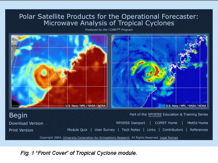
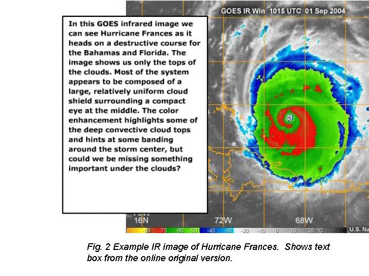
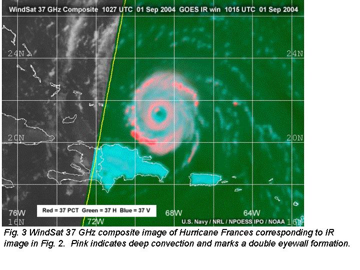
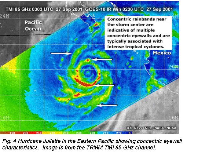
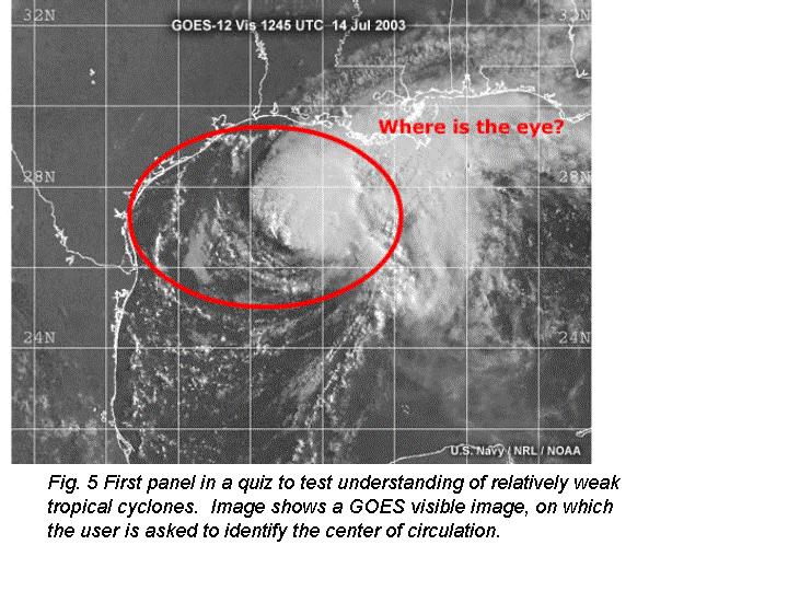
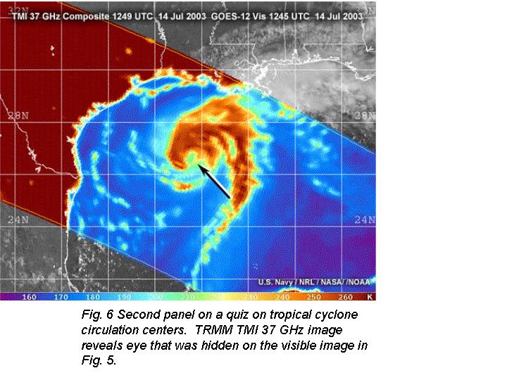
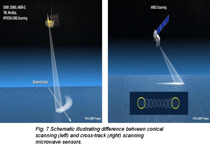
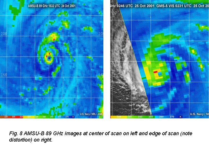
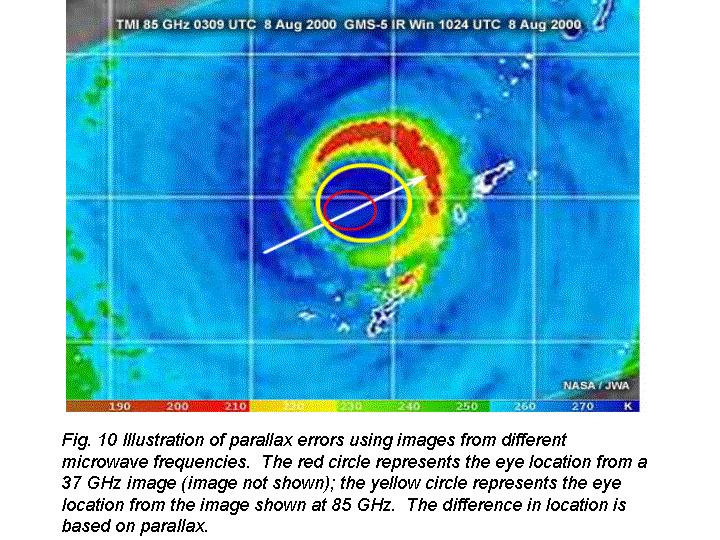
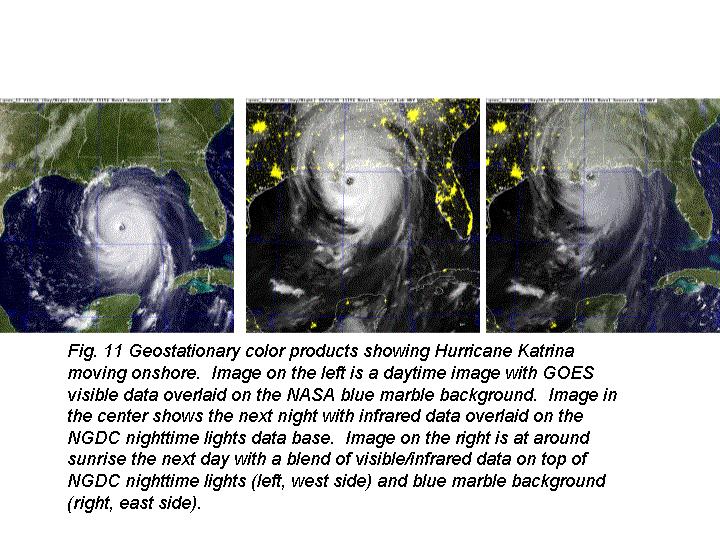
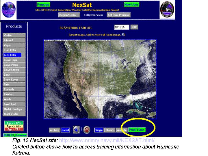
2 learning more about the mission, spacecraft, instrumentation, data processing, products, and applications: 3. Satellite Training on Tropical Cyclones at the Naval Research Laboratory The Naval Research Laboratory (NRL) Monterey is charged with providing appropriate examples and content to COMET developers to demonstrate future NPOESS capabilities. With respect to tropical cyclones, NRL is uniquely positioned for this role because of its web site which shows live satellite images, especially from microwave sensors, for every storm on a global, year-round basis: ( using existing satellite data streams from polar and geostationary satellites (Hawkins et al. 2001; Lee et al. 2002). The Tropical Cyclone Analysis module which focuses on the use of passive microwave images for the analysis and fixing of tropical cyclones (front page shown in Fig. 1) is one of the most popular COMET modules on satellite meteorology: The module is divided into ten sections (Table 1) with illustrations and example products appearing throughout. There are also tables to summarize key information (e.g., Table 2). The module emphasizes the difference between infrared images, the standard used for analyzing tropical cyclones, and passive microwave images that have been increasingly used by forecasters since the launch of the first SSM/I in Fig. 2 shows an example of an infrared image of Hurricane Frances in 2004, showing a cirrus canopy with low temperatures in red near the center. Fig. 3 is the corresponding composite based on observations from the U.S. Navy research and development microwave sensor, WindSat, aboard the Coriolis satellite. The microwave data reveals a double eye wall structure that is hidden beneath the cirrus canopy on Fig. 2. Fig. 4 also demonstrates concentric eyewall characteristics, but this time for Hurricane Juliette in the Eastern Pacific based on TRMM TMI data. Figs. 5 and 6 present a quiz question, the former asking the question and the latter showing the answer. The interspersed questions throughout the module help reinforce key elements of the material and accelerate learning. Fig. 7 shows the difference between cross track and conical scan strategies. Both strategies are used in the passive microwave imaging of tropical cyclones, but there are important ramifications to the use of each. In Fig. 8 we see the distortion arising at the edge of scan with the cross-scanning arising from the AMSU-B sensor. Fig. 9 illustrates how satellite parallax creates displacement of elevated features, such as clouds, with respect to the earth. Fig. 10 illustrates the effect of parallax on microwave images. 4. Other NRL Training NRL also maintains training on its NexSat satellite site (Miller et al 2006): This site is a realtime display of a number of experimental satellite products to illustrate advances in polar satellite capabilities in anticipation of NPOESS. Products which blend geostationary and polar capabilities are also emphasized, for example geostationary color as shown in Fig. 11. This example of Hurricane Katrina shows visible data overlaid upon the NASA blue marble background during the daytime. At night infrared data are overlaid upon a background that incorporates nighttime city lights from the National Geophysical Data Center (NGDC). The NexSat page contains a detailed training tutorial in pdf form (green button shown in Fig. 12). Similar training product tutorials are available for all of the experimental applications listed on the left side ( Products list) of the interface. 5. Acknowledgements The support of the research sponsor, the National Polar-orbiting Operational Environmental Satellite System s (NPOESS) Integrated Program Office (IPO) located in Silver Spring, MD, is gratefully acknowledged. The support of the research sponsors, the Oceanographer of the Navy through the program office at the PEO C4I&Space/PMW- 180, under program element PE N and the Office of Naval Research under program element PE N is gratefully acknowledged. 6. References Hawkins, J.D., T. Lee, J. Turk, C. Sampson, J. Kent, and K. Richardson, 2001: Real-time Internet distribution of satellite products for tropical cyclone reconnaissance. Bull. Amer. Met. Soc., 82, Lee, T.F., F.J. Turk, J.D. Hawkins, and K.A. Richardson, 2002: Interpretation of TRMM TMI images of tropical cyclones. Earth Interactions E- Journal 6:3.
3 Miller, S. D., J. D. Hawkins, J. Kent, F. J. Turk, T. F. Lee, A. P. Kuciauskas, K. Richardson, R. Wade, and C. Hoffman, 2006: NEXSAT: Previewing NPOESS/VIIRS Imagery Capabilities, Bull. Amer. Met. Soc., in press (April issue). Table 1 Table of Contents Using Microwave Observations for Tropical Cyclone Analysis 1.0 Overview 2.0 Tropical Cyclone Examples 3.0 Current Passive Microwave Sensors 4.0 Improvements with NPOESS CMIS 5.0 Characteristics of Microwave Imagery to 91 GHz Imagery -- Interpretation 7.0 Multispectral Examples and Exercises 8.0 Concentric Eyewall Characteristics 9.0 Summary 10.0 Exercises Table 2 Comparing Active and Passive Microwave Sensors
4
5
6
7

8
9
NEAR REAL-TIME CLOUDSAT PROCESSING AT THE NAVAL RESEARCH LABORATORY
 NEAR REAL-TIME CLOUDSAT PROCESSING AT THE NAVAL RESEARCH LABORATORY Cristian Mitrescu 1, Steven Miller 2, Jeffrey Hawkins 1, Tristan L Ecuyer 3, Joseph Turk 1, and Philip Partain 4 1 Naval Research Laboratory,
Lecture 19: Operational Remote Sensing in Visible, IR, and Microwave Channels
 MET 4994 Remote Sensing: Radar and Satellite Meteorology MET 5994 Remote Sensing in Meteorology Lecture 19: Operational Remote Sensing in Visible, IR, and Microwave Channels Before you use data from any
P4.1 CONSENSUS ESTIMATES OF TROPICAL CYCLONE INTENSITY USING MULTISPECTRAL (IR AND MW) SATELLITE OBSERVATIONS
 SATELLITE OBSERVATIONS") P4.1 CONSENSUS ESTIMATES OF TROPICAL CYCLONE INTENSITY USING MULTISPECTRAL (IR AND MW) SATELLITE OBSERVATIONS Christopher Velden* Derrick C. Herndon and James Kossin University of Wisconsin Cooperative
P4.1 CONSENSUS ESTIMATES OF TROPICAL CYCLONE INTENSITY USING MULTISPECTRAL (IR AND MW) SATELLITE OBSERVATIONS Christopher Velden* Derrick C. Herndon and James Kossin University of Wisconsin Cooperative
NOAA/NESDIS Tropical Web Page with LEO Satellite Products and Applications for Forecasters
 NOAA/NESDIS Tropical Web Page with LEO Satellite Products and Applications for Forecasters Sheldon Kusselson National Oceanic and Atmospheric Administration (NOAA) National Environmental Satellite Data
Interpretation of Polar-orbiting Satellite Observations. Atmospheric Instrumentation
 Interpretation of Polar-orbiting Satellite Observations Outline Polar-Orbiting Observations: Review of Polar-Orbiting Satellite Systems Overview of Currently Active Satellites / Sensors Overview of Sensor
Remotely Sensed Tropical Cyclone Structure/Intensity Changes
 Remotely Sensed Tropical Cyclone Structure/Intensity Changes Jeffrey D. Hawkins Naval Research Laboratory Monterey, CA 93943-5502 (831) 656-4833, fax (831) 656-6006, hawkins@nrlmry.navy.mil Award #: N0001400WX20251
Evaluating Icing Nowcasts using CloudSat
 National Weather Association, Electronic Journal of Operational Meteorology, 2010-EJ2 Evaluating Icing Nowcasts using CloudSat Thomas F. Lee*, Cristian Mitrescu, Richard Bankert Naval Research Laboratory,
Before the FEDERAL COMMUNICATIONS COMMISSION Washington, DC 20554
 Before the FEDERAL COMMUNICATIONS COMMISSION Washington, DC 20554 In the Matter of ) ) Recommendations Approved by the ) Advisory Committee for the 2007 World ) IB Docket No. 04-286 Radiocommunication
Satellite User Readiness through Training: VISIT, SHyMet, WMO VLab, and Liaisons
 Satellite User Readiness through Training: VISIT, SHyMet, WMO VLab, and Liaisons Bernadette Connell 1 D. Bikos 1, S. Lindstrom 2, J. Torres 1, E. J. Szoke 1, E. L. Dagg 1, A. B. Schumacher 1, A. S. Bachmeier
P6.13 GLOBAL AND MONTHLY DIURNAL PRECIPITATION STATISTICS BASED ON PASSIVE MICROWAVE OBSERVATIONS FROM AMSU
 P6.13 GLOBAL AND MONTHLY DIURNAL PRECIPITATION STATISTICS BASED ON PASSIVE MICROWAVE OBSERVATIONS FROM AMSU Frederick W. Chen*, David H. Staelin, and Chinnawat Surussavadee Massachusetts Institute of Technology,
P1.21 Estimating TC Intensity Using the SSMIS and ATMS Sounders
 P1.21 Estimating TC Intensity Using the SSMIS and ATMS Sounders Derrick C. Herndon* and Christopher Velden University of Wisconsin Cooperative Institute for Meteorological Satellite Studies (UW-CIMSS)
Pre-Operational Assimilation Testing of the Defense Meteorological Satellite Program (DMSP) Special Sensor Microwave Imager/Sounder (SSMI/S)
 Special Sensor Microwave Imager/Sounder (SSMI/S)") Pre-Operational Assimilation Testing of the Defense Meteorological Satellite Program (DMSP) Special Sensor Microwave Imager/Sounder (SSMI/S) William Campbell 1, Steve Swadley 2, William Bell 3, Clay Blankenship
Pre-Operational Assimilation Testing of the Defense Meteorological Satellite Program (DMSP) Special Sensor Microwave Imager/Sounder (SSMI/S) William Campbell 1, Steve Swadley 2, William Bell 3, Clay Blankenship
The UW-CIMSS Advanced Dvorak Technique (ADT) : An Automated IR Method to Estimate Tropical Cyclone Intensity
 : An Automated IR Method to Estimate Tropical Cyclone Intensity") The UW-CIMSS Advanced (ADT) : An Automated IR Method to Estimate Tropical Cyclone Intensity Timothy Olander and Christopher Velden University of Wisconsin Madison, USA Cooperative Institute for Meteorological
The UW-CIMSS Advanced (ADT) : An Automated IR Method to Estimate Tropical Cyclone Intensity Timothy Olander and Christopher Velden University of Wisconsin Madison, USA Cooperative Institute for Meteorological
ENHANCED TROPICAL CYCLONE MONITORING WITH MODIS AND OLS
 15A.6 ENHANCED TROPICAL CYCLONE MONITORING WITH MODIS AND OLS Steven D. Miller *, Jeffrey D. Hawkins, Kim Richardson, Thomas F. Lee, and F. Joseph Turk Naval Research Laboratory, Monterey, CA 1. INTRODUCTION
Real-Time Internet Distribution of Satellite Products for Tropical Cyclone Reconnaissance
 Real-Time Internet Distribution of Satellite Products for Tropical Cyclone Reconnaissance Jeffrey D. Hawkins,* Thomas F. Lee,* Joseph Turk,* Charles Sampson,* John Kent, + and Kim Richardson* ABSTRACT
"Cloud and Rainfall Observations using Microwave Radiometer Data and A-priori Constraints" Christian Kummerow and Fang Wang Colorado State University
 "Cloud and Rainfall Observations using Microwave Radiometer Data and A-priori Constraints" Christian Kummerow and Fang Wang Colorado State University ECMWF-JCSDA Workshop Reading, England June 16-18, 2010
URSI-F Microwave Signatures Meeting 2010, Florence, Italy, October 4 8, Thomas Meissner Lucrezia Ricciardulli Frank Wentz
 URSI-F Microwave Signatures Meeting 2010, Florence, Italy, October 4 8, 2010 Wind Measurements from Active and Passive Microwave Sensors High Winds and Winds in Rain Thomas Meissner Lucrezia Ricciardulli
Observations Team: Satellite Observation Update. John Knaff NOAA/NESDIS Regional and Mesoscale Meteorology Branch
 Observations Team: Satellite Observation Update John Knaff NOAA/NESDIS Regional and Mesoscale Meteorology Branch 1 FY12 Satellite Milestones: i. CIRA/RAMMB continue maintaining and populating real-time
F O U N D A T I O N A L C O U R S E
 F O U N D A T I O N A L C O U R S E December 6, 2018 Satellite Foundational Course for JPSS (SatFC-J) F O U N D A T I O N A L C O U R S E Introduction to Microwave Remote Sensing (with a focus on passive
Derrick Herndon and Chris Velden University of Wisconsin - Madison Cooperative Institute for Meteorological Satellite Studies
 CIMSS SATellite CONsensus (SATCON) Derrick Herndon and Chris Velden University of Wisconsin - Madison Cooperative Institute for Meteorological Satellite Studies Presented at International Workshop on Satellite
Division, 7 Grace Hopper Ave., Monterey, CA 93943, Tel: (831) ,
 ,") P6.20 PRECIPITATION SIGNATURES IN SSMIS IMAGERY F.J. Turk 1 T.F. Lee 1, S.D. Miller 1, R. Ferraro 2, F. Weng 2 1 Naval Research Laboratory, Marine Meteorology Division, Monterey, CA USA 2 NOAA-NESDIS,
P6.20 PRECIPITATION SIGNATURES IN SSMIS IMAGERY F.J. Turk 1 T.F. Lee 1, S.D. Miller 1, R. Ferraro 2, F. Weng 2 1 Naval Research Laboratory, Marine Meteorology Division, Monterey, CA USA 2 NOAA-NESDIS,
Preparing for NOAA s Next Generation GOES-R & JPSS
 Preparing for NOAA s Next Generation GOES-R & JPSS Mark Paese Deputy Assistant Administrator NOAA Environmental Satellite & Information Service (NESDIS) WMO Cg-17: Ensuring User Readiness for New Generation
P3.24 EVALUATION OF MODERATE-RESOLUTION IMAGING SPECTRORADIOMETER (MODIS) SHORTWAVE INFRARED BANDS FOR OPTIMUM NIGHTTIME FOG DETECTION
 SHORTWAVE INFRARED BANDS FOR OPTIMUM NIGHTTIME FOG DETECTION") P3.24 EVALUATION OF MODERATE-RESOLUTION IMAGING SPECTRORADIOMETER (MODIS) SHORTWAVE INFRARED BANDS FOR OPTIMUM NIGHTTIME FOG DETECTION 1. INTRODUCTION Gary P. Ellrod * NOAA/NESDIS/ORA Camp Springs, MD
P3.24 EVALUATION OF MODERATE-RESOLUTION IMAGING SPECTRORADIOMETER (MODIS) SHORTWAVE INFRARED BANDS FOR OPTIMUM NIGHTTIME FOG DETECTION 1. INTRODUCTION Gary P. Ellrod * NOAA/NESDIS/ORA Camp Springs, MD
APPENDIX 2 OVERVIEW OF THE GLOBAL PRECIPITATION MEASUREMENT (GPM) AND THE TROPICAL RAINFALL MEASURING MISSION (TRMM) 2-1
 AND THE TROPICAL RAINFALL MEASURING MISSION (TRMM) 2-1") APPENDIX 2 OVERVIEW OF THE GLOBAL PRECIPITATION MEASUREMENT (GPM) AND THE TROPICAL RAINFALL MEASURING MISSION (TRMM) 2-1 1. Introduction Precipitation is one of most important environmental parameters.
APPENDIX 2 OVERVIEW OF THE GLOBAL PRECIPITATION MEASUREMENT (GPM) AND THE TROPICAL RAINFALL MEASURING MISSION (TRMM) 2-1 1. Introduction Precipitation is one of most important environmental parameters.
Detailed Cloud Motions from Satellite Imagery Taken at Thirty Second One and Three Minute Intervals
 Detailed Cloud Motions from Satellite Imagery Taken at Thirty Second One and Three Minute Intervals James F.W. Purdom NOAA/NESDIS/RAMM Branch CIRA Colorado State University W. Laporte Avenue Fort Collins,
STATUS AND DEVELOPMENT OF SATELLITE WIND MONITORING BY THE NWP SAF
 STATUS AND DEVELOPMENT OF SATELLITE WIND MONITORING BY THE NWP SAF Mary Forsythe (1), Antonio Garcia-Mendez (2), Howard Berger (1,3), Bryan Conway (4), Sarah Watkin (1) (1) Met Office, Fitzroy Road, Exeter,
Remote Sensing in Meteorology: Satellites and Radar. AT 351 Lab 10 April 2, Remote Sensing
 Remote Sensing in Meteorology: Satellites and Radar AT 351 Lab 10 April 2, 2008 Remote Sensing Remote sensing is gathering information about something without being in physical contact with it typically
HIGH-RESOLUTION SATELLITE-DERIVED WIND FIELDS PE (035-71)
") HIGH-RESOLUTION SATELLITE-DERIVED WIND FIELDS PE 0602435 (035-71) Jeffrey D. Hawkins Naval Research Laboratory Monterey, CA 93943-5502 Ph (408) 656-4833/ Fax (408) 656-4769 hawkins@nrlmry.navy.mil LONG-TERM
HIGH-RESOLUTION SATELLITE-DERIVED WIND FIELDS PE 0602435 (035-71) Jeffrey D. Hawkins Naval Research Laboratory Monterey, CA 93943-5502 Ph (408) 656-4833/ Fax (408) 656-4769 hawkins@nrlmry.navy.mil LONG-TERM
JTWC's Use of TRMM in Typhoon Forecast Operations
 Use of TRMM in Typhoon Forecast Operations JTWC's Use of TRMM in Typhoon Forecast Operations Slide 1/24 Use of TRMM in Typhoon Forecast Operations Slide 2/24 Opening Comments The current microwave satellite
NES: Weather and Climate: Satellite Meteorology
 LIVE INTERACTIVE LEARNING @ YOUR DESKTOP NES: Weather and Climate: Satellite Meteorology Presented by: Rudo Kashiri January 23, 2012 Weather and Climate: Satellite Meteorology Presented by Rudo Kashiri
ARCHIVED REPORT. Defense Meteorological Satellite Program - Archived 11/2005
 Electronic Systems Forecast ARCHIVED REPORT For data and forecasts on current programs please visit www.forecastinternational.com or call +1 203.426.0800 Defense Meteorological Satellite Program - Archived
Weather and Climate: Satellite Meteorology
 LIVE INTERACTIVE LEARNING @ YOUR DESKTOP Weather and Climate: Satellite Meteorology Presented by: Rudo Kashiri April 4, 2013 6:30 p.m. 8:00 p.m. Eastern time 1 2 http://learningcenter.nsta.org NSTA Learning
Outline of 4 Lectures
 Outline of 4 Lectures 1. Sept. 17, 2008: TC best track definition and datasets, global distribution of TCs; Review of history of meteorological satellites, introducing different orbits, scanning patterns,
ASSIMILATION EXPERIMENTS WITH DATA FROM THREE CONICALLY SCANNING MICROWAVE INSTRUMENTS (SSMIS, AMSR-E, TMI) IN THE ECMWF SYSTEM
 IN THE ECMWF SYSTEM") ASSIMILATION EXPERIMENTS WITH DATA FROM THREE CONICALLY SCANNING MICROWAVE INSTRUMENTS (SSMIS, AMSR-E, TMI) IN THE ECMWF SYSTEM Niels Bormann 1, Graeme Kelly 1, Peter Bauer 1, and Bill Bell 2 1 ECMWF,
ASSIMILATION EXPERIMENTS WITH DATA FROM THREE CONICALLY SCANNING MICROWAVE INSTRUMENTS (SSMIS, AMSR-E, TMI) IN THE ECMWF SYSTEM Niels Bormann 1, Graeme Kelly 1, Peter Bauer 1, and Bill Bell 2 1 ECMWF,
Feel free to ask for help also, we will try our best to answer your question or at least direct you to where you can find the answer.
 Page 1 Objectives: Become familiar with online resources and image searching tools Interpret different types of satellite imagery Learn about the variety of different types of TCs Part 1: Browse available
P1.23 HISTOGRAM MATCHING OF ASMR-E AND TMI BRIGHTNESS TEMPERATURES
 P1.23 HISTOGRAM MATCHING OF ASMR-E AND TMI BRIGHTNESS TEMPERATURES Thomas A. Jones* and Daniel J. Cecil Department of Atmospheric Science University of Alabama in Huntsville Huntsville, AL 1. Introduction
Satellite-Derived Tropical Cyclone Structure and Intensity
 DISTRIBUTION STATEMENT A. Approved for public release; distribution is unlimited. Satellite-Derived Tropical Cyclone Structure and Intensity Jeffrey D. Hawkins Naval Research Laboratory 7 Grace Hopper
P1.6 Simulation of the impact of new aircraft and satellite-based ocean surface wind measurements on H*Wind analyses
 P1.6 Simulation of the impact of new aircraft and satellite-based ocean surface wind measurements on H*Wind analyses Timothy L. Miller 1, R. Atlas 2, P. G. Black 3, J. L. Case 4, S. S. Chen 5, R. E. Hood
Hurricane Structure: Theory and Diagnosis
 Hurricane Structure: Theory and Diagnosis 7 March, 2016 World Meteorological Organization Workshop Chris Landsea Chris.Landsea@noaa.gov National Hurricane Center, Miami Outline Structure of Hurricanes
391 FACILITATING TROPICAL CYCLONE ANALYSIS OF HURRICANE SATELLITE (HURSAT) IMAGERY WITH GOOGLE EARTH
 IMAGERY WITH GOOGLE EARTH") 391 FACILITATING TROPICAL CYCLONE ANALYSIS OF HURRICANE SATELLITE (HURSAT) IMAGERY WITH GOOGLE EARTH Philip T. Bergmaier* Millersville University, Millersville, Pennsylvania Kenneth R. Knapp NOAA National
391 FACILITATING TROPICAL CYCLONE ANALYSIS OF HURRICANE SATELLITE (HURSAT) IMAGERY WITH GOOGLE EARTH Philip T. Bergmaier* Millersville University, Millersville, Pennsylvania Kenneth R. Knapp NOAA National
Joint Polar Satellite System. 3 rd Post-EPS User Consultation Workshop Mike Haas
 3 rd Post-EPS User Consultation Workshop Mike Haas Overview Introduction - Policy Drivers - Management System Description - Space Segment - Ground Segment Partnerships Status Benefits 2 Introduction (Policy
16D.3 EYEWALL LIGHTNING OUTBREAKS AND TROPICAL CYCLONE INTENSITY CHANGE
 16D.3 EYEWALL LIGHTNING OUTBREAKS AND TROPICAL CYCLONE INTENSITY CHANGE Nicholas W. S. Demetriades and Ronald L. Holle Vaisala Inc., Tucson, Arizona, USA Steven Businger University of Hawaii Richard D.
4B.4 HURRICANE SATELLITE (HURSAT) DATA SETS: LOW EARTH ORBIT INFRARED AND MICROWAVE DATA
 DATA SETS: LOW EARTH ORBIT INFRARED AND MICROWAVE DATA") 4B.4 HURRICANE SATELLITE (HURSAT) DATA SETS: LOW EARTH ORBIT INFRARED AND MICROWAVE DATA Kenneth R. Knapp* NOAA - National Climatic Data Center, Asheville, North Carolina 1. INTRODUCTION Given the recent
4B.4 HURRICANE SATELLITE (HURSAT) DATA SETS: LOW EARTH ORBIT INFRARED AND MICROWAVE DATA Kenneth R. Knapp* NOAA - National Climatic Data Center, Asheville, North Carolina 1. INTRODUCTION Given the recent
A MEDIUM EARTH ORBIT CONTELLATION FOR POLAR WIND MEASUREMENTS
 A MEDIUM EARTH ORBIT CONTELLATION FOR POLAR WIND MEASUREMENTS Gerald J. Dittberner 1, Shyam N. Bajpai 1, Andrew J. Gerber, jr. 2, Richard Baron 2, Francois Rogez 2 1 U.S. National Oceanic and Atmospheric
Assimilation of Long-Range Lightning Data over the Pacific
 Assimilation of Long-Range Lightning Data over the Pacific Principal Investigator: Professor Steven Businger Meteorology Department University of Hawaii 2525 Correa Road Honolulu, HI 96822 USA Telephone:
Welcome and Introduction
 Welcome and Introduction Riko Oki Earth Observation Research Center (EORC) Japan Aerospace Exploration Agency (JAXA) 7th Workshop of International Precipitation Working Group 17 November 2014 Tsukuba International
Chapter 10 Assessing Hurricane Intensity Using Satellites
 Chapter 10 Assessing Hurricane Intensity Using Satellites Mark DeMaria, John A. Knaff, and Raymond Zehr Abstract Tropical cyclones spend most of their life cycle over the tropical and subtropical oceans.
Microwave-TC intensity estimation. Ryo Oyama Meteorological Research Institute Japan Meteorological Agency
 Microwave-TC intensity estimation Ryo Oyama Meteorological Research Institute Japan Meteorological Agency Contents 1. Introduction 2. Estimation of TC Maximum Sustained Wind (MSW) using TRMM Microwave
TIROS-1. 1) National Aeronautics and Space Administration 2) National Oceanic and Atmospheric Administration
 National Aeronautics and Space Administration 2) National Oceanic and Atmospheric Administration") NOAA TIROS-1 NASA 1) National Aeronautics and Space Administration 2) National Oceanic and Atmospheric Administration Sputnik Sputlink Aerobee Aerobee TIROS-1 TIROS-1 1) Spiral swirl SeaWIFS Orb View2
NOAA TIROS-1 NASA 1) National Aeronautics and Space Administration 2) National Oceanic and Atmospheric Administration Sputnik Sputlink Aerobee Aerobee TIROS-1 TIROS-1 1) Spiral swirl SeaWIFS Orb View2
The Transition of Atmospheric Infrared Sounder Total Ozone Products to Operations
 The Transition of Atmospheric Infrared Sounder Total Ozone Products to Operations Emily Berndt 1, Bradley Zavodsky 2, Gary Jedlovec 2 1 NASA Postdoctoral Program Marshall Space Flight Center, Huntsville,
The Properties of Convective Clouds Over the Western Pacific and Their Relationship to the Environment of Tropical Cyclones
 The Properties of Convective Clouds Over the Western Pacific and Their Relationship to the Environment of Tropical Cyclones Principal Investigator: Dr. Zhaoxia Pu Department of Meteorology, University
Space Based Global Observing System Requirements for Satellite Sounders. Dr. Jian Liu Space Programme World Meteorological Organization
 Space Based Global Observing System Requirements for Satellite Sounders Dr. Jian Liu Space Programme World Meteorological Organization Outline 1. satellite sounders capabilities 2. User requirements 3.
SAN FRANCISCO STATE UNIVERSITY NAME DEPARTMENT OF GEOSCIENCES Spring 2013
 SAN FRANCISCO STATE UNIVERSITY NAME DEPARTMENT OF GEOSCIENCES Spring 2013 METR 415/715: MONTEVERDI QUIZ 1 Open Book and Open Notes 200 points, 45 minutes 1. Compute the altitude of a geostationary orbit
Overview of COMET Training for Ensemble Products
 Overview of COMET Training for Ensemble Products Dr. Gregory Byrd Senior Project Manager UCAR/COMET NUOPC Workshop Boulder, CO 16 August 2010 The COMET Program Founded 1989 Staff of 48, including NWS and
P1.44 DISTANCE LEARNING METHODS FOR NUMERICAL WEATHER PREDICTION (NWP) PROFESSIONAL DEVELOPMENT TRAINING
 PROFESSIONAL DEVELOPMENT TRAINING") P1.44 DISTANCE LEARNING METHODS FOR NUMERICAL WEATHER PREDICTION (NWP) PROFESSIONAL DEVELOPMENT TRAINING Stephen D. Jascourt 1 and William R. Bua 2, UCAR/COMET Silver Spring, MD 1 and Camp Springs, MD
P1.44 DISTANCE LEARNING METHODS FOR NUMERICAL WEATHER PREDICTION (NWP) PROFESSIONAL DEVELOPMENT TRAINING Stephen D. Jascourt 1 and William R. Bua 2, UCAR/COMET Silver Spring, MD 1 and Camp Springs, MD
Derrick Herndon and Chris Velden University of Wisconsin - Madison Cooperative Institute for Meteorological Satellite Studies
 Derrick Herndon and Chris Velden University of Wisconsin - Madison Cooperative Institute for Meteorological Satellite Studies Presented at International Workshop on Satellite Analysis of Tropical Cyclones
THE STATUS OF THE NOAA/NESDIS OPERATIONAL AMSU PRECIPITATION ALGORITHM
 THE STATUS OF THE NOAA/NESDIS OPERATIONAL AMSU PRECIPITATION ALGORITHM R.R. Ferraro NOAA/NESDIS Cooperative Institute for Climate Studies (CICS)/ESSIC 2207 Computer and Space Sciences Building Univerisity
How does NASA study hurricanes? 17 August 2015, by Max Gleber
 How does NASA study hurricanes? 17 August 2015, by Max Gleber Hurricanes are the most powerful weather event on Earth. NASA's expertise in space and scientific exploration contributes to essential services
Data Format and Visualization Agenda
 Data Format and Visualization Agenda- 7.2.2 ET-SUP-8 (14.04.2014) Suman Goyal, Satellite Meteorology Division, India Meteorological Department, Suman_goyal61@yahoo.co.in Visualization Methods The satellite
28th Conference on Hurricanes and Tropical Meteorology, 28 April 2 May 2008, Orlando, Florida.
 P2B. TROPICAL INTENSITY FORECASTING USING A SATELLITE-BASED TOTAL PRECIPITABLE WATER PRODUCT Mark DeMaria* NOAA/NESDIS/StAR, Fort Collins, CO Jeffery D. Hawkins Naval Research Laboratory, Monterey, CA
Atmospheric Motions Derived From Space Based Measurements: A Look To The Near Future. James F.W. Purdom
 Atmospheric Motions Derived From Space Based Measurements: A Look To The Near Future James F.W. Purdom Director, Office of Research and Applications NOAA/NESDIS 1. Introduction This short note addresses
OSE/OSSEs at NOAA. Eric Bayler NOAA/NESDIS/STAR
 OSE/OSSEs at NOAA Eric Bayler NOAA/NESDIS/STAR OSE/OSSEs at NOAA NOAA Leadership view: Relatively inexpensive way to: Assess the impact of potential new observations Refine and redirect current observing
New NASA Ocean Observations and Coastal Applications
 New NASA Ocean Observations and Coastal Applications Duane Armstrong Chief, Applied Science & Technology Project Office August 20, 2014 1 Outline NASA s new Earth Science Ocean Science Missions for 2014
Introduction of the Hyperspectral Environmental Suite (HES) on GOES-R and beyond
 on GOES-R and beyond") Introduction of the Hyperspectral Environmental Suite (HES) on GOES-R and beyond 1 Timothy J. Schmit, 2 Jun Li, 3 James Gurka 1 NOAA/NESDIS, Office of Research and Applications, Advanced Satellite Products
Introduction of the Hyperspectral Environmental Suite (HES) on GOES-R and beyond 1 Timothy J. Schmit, 2 Jun Li, 3 James Gurka 1 NOAA/NESDIS, Office of Research and Applications, Advanced Satellite Products
The NOAA/NESDIS/STAR IASI Near Real-Time Product Processing and Distribution System
 The NOAA/NESDIS/STAR Near Real-Time Product Processing and Distribution System W. Wolf 2, T. King 1, Z. Cheng 1, W. Zhou 1, H. Sun 1, P. Keehn 1, L. Zhou 1, C. Barnet 2, and M. Goldberg 2 1 QSS Group Inc,
Detecting Tropical Cyclone Structural Change with the TRMM Precipitation Radar (PR) and Advanced Microwave Sounding Unit (AMSU)
 and Advanced Microwave Sounding Unit (AMSU)") Detecting Tropical Cyclone Structural Change with the TRMM Precipitation Radar (PR) and Advanced Microwave Sounding Unit (AMSU) Stephen R. Guimond 1 *, F. Joseph Turk 2, Clay B. Blankenship 2 and Jeffrey
Detecting Tropical Cyclone Structural Change with the TRMM Precipitation Radar (PR) and Advanced Microwave Sounding Unit (AMSU) Stephen R. Guimond 1 *, F. Joseph Turk 2, Clay B. Blankenship 2 and Jeffrey
EVALUATION OF GPM-ERA CONSTELLATION PRECIPITATION ESTIMATES FOR LAND SURFACE MODELING APPLICATIONS
 EVALUATION OF GPM-ERA CONSTELLATION PRECIPITATION ESTIMATES FOR LAND SURFACE MODELING APPLICATIONS F.Joseph Turk 1, G. Mostovoy 2, V. Anantharaj 2, P. Houser 3, QiQi Lu 4, Y. Ling 2 1 Naval Research Laboratory,
Lecture 4b: Meteorological Satellites and Instruments. Acknowledgement: Dr. S. Kidder at Colorado State Univ.
 Lecture 4b: Meteorological Satellites and Instruments Acknowledgement: Dr. S. Kidder at Colorado State Univ. US Geostationary satellites - GOES (Geostationary Operational Environmental Satellites) US
3.7 MYWXMAP: A NEW APPRAOCH TO WEB-BASED METEOROLOGICAL AND OCEANOGRAPHIC (METOC) CHART DISPLAY
 CHART DISPLAY") 3.7 MYWXMAP: A NEW APPRAOCH TO WEB-BASED METEOROLOGICAL AND OCEANOGRAPHIC (METOC) CHART DISPLAY Carl D. Thormeyer* and Earl V. Ravid Fleet Numerical Meteorology and Oceanography Center (FNMOC) Monterey,
3.7 MYWXMAP: A NEW APPRAOCH TO WEB-BASED METEOROLOGICAL AND OCEANOGRAPHIC (METOC) CHART DISPLAY Carl D. Thormeyer* and Earl V. Ravid Fleet Numerical Meteorology and Oceanography Center (FNMOC) Monterey,
JPSS GEONETCAST REQUIREMENTS DISCUSSION
 Joint Polar Satellite System (JPSS) JPSS GEONETCAST REQUIREMENTS DISCUSSION Mitch Goldberg Program Scientist Joint Polar Satellite System National Environmental Satellite, Data, and Information Service
EVALUATION OF WINDSAT SURFACE WIND DATA AND ITS IMPACT ON OCEAN SURFACE WIND ANALYSES AND NUMERICAL WEATHER PREDICTION
 5.8 EVALUATION OF WINDSAT SURFACE WIND DATA AND ITS IMPACT ON OCEAN SURFACE WIND ANALYSES AND NUMERICAL WEATHER PREDICTION Robert Atlas* NOAA/Atlantic Oceanographic and Meteorological Laboratory, Miami,
Overview and Access to GPCP, TRMM, and GPM Precipitation Data Products
 National Aeronautics and Space Administration ARSET Applied Remote Sensing Training http://arset.gsfc.nasa.gov @NASAARSET Overview and Access to GPCP, TRMM, and GPM Precipitation Data Products www.nasa.gov
1. INTRODUCTION 2. THE CLOUDSAT OBSERVING SYSTEM: THE 94-GHZ RADAR. 2.1 The Radar Model
 JP2.6 LIGHT RAIN RETRIEVALS USING CLOUDSAT 94-GHZ RADAR DATA - PRELIMINARY RESULTS Cristian Mitrescu 1 John M. Haynes 2 Tristan L Ecuyer 2 Steven D. Miller 1 Joe Turk 1 1 Naval Research Laboratory, Marine
International Cooperation in Operational Environmental Satellites: The U.S. Experience
 Committee on the Peaceful Uses of Outer Space Science and Technology Sub committee Forty seventh session February 17, 2010 Vienna, Austria International Cooperation in Operational Environmental Satellites:
Japanese Programs on Space and Water Applications
 Japanese Programs on Space and Water Applications Tamotsu IGARASHI Remote Sensing Technology Center of Japan June 2006 COPUOS 2006 Vienna International Centre Water-related hazards/disasters may occur
Network of Direct Broadcast Antenna Systems to Provide Real-Time Infrared and Microwave Sounder Data to NOAA for Numerical Weather Prediction
 Sandy Supplemental Grant Recipient Quarterly Progress Report Network of Direct Broadcast Antenna Systems to Provide Real-Time Infrared and Microwave Sounder Data to NOAA for Numerical Award Number: NA13NES4830007
8A.2 PRE-OPERATIONAL ASSIMILATION TESTING OF THE DEFENSE METEOROLOGICAL SATELLITE PROGRAM (DMSP) SPECIAL SENSOR MICROWAVE IMAGER/SOUNDER (SSMI/S)
 SPECIAL SENSOR MICROWAVE IMAGER/SOUNDER (SSMI/S)") 8A.2 PRE-OPERATIONAL ASSIMILATION TESTING OF THE DEFENSE METEOROLOGICAL SATELLITE PROGRAM (DMSP) SPECIAL SENSOR MICROWAVE IMAGER/SOUNDER (SSMI/S) William Campbell*, Nancy Baker, Clay Blankenship, Benjamin
8A.2 PRE-OPERATIONAL ASSIMILATION TESTING OF THE DEFENSE METEOROLOGICAL SATELLITE PROGRAM (DMSP) SPECIAL SENSOR MICROWAVE IMAGER/SOUNDER (SSMI/S) William Campbell*, Nancy Baker, Clay Blankenship, Benjamin
Fifty Years of Operational Environmental Satellites: The U.S. Experience
 United Nations Committee on the Peaceful Uses of Outer Space Vienna, Austria June 15, 2010 Fifty Years of Operational Environmental Satellites: The U.S. Experience Mr. Charles Baker Deputy Assistant Administrator
Daily OI SST Trip Report Richard W. Reynolds National Climatic Data Center (NCDC) Asheville, NC July 29, 2005
 Asheville, NC July 29, 2005") Daily OI SST Trip Report Richard W. Reynolds National Climatic Data Center (NCDC) Asheville, NC July 29, 2005 I spent the month of July 2003 working with Professor Dudley Chelton at the College of Oceanic
Daily OI SST Trip Report Richard W. Reynolds National Climatic Data Center (NCDC) Asheville, NC July 29, 2005 I spent the month of July 2003 working with Professor Dudley Chelton at the College of Oceanic
291. IMPACT OF AIRS THERMODYNAMIC PROFILES ON PRECIPITATION FORECASTS FOR ATMOSPHERIC RIVER CASES AFFECTING THE WESTERN UNITED STATES
 291. IMPACT OF AIRS THERMODYNAMIC PROFILES ON PRECIPITATION FORECASTS FOR ATMOSPHERIC RIVER CASES AFFECTING THE WESTERN UNITED STATES Clay B. Blankenship, USRA, Huntsville, Alabama Bradley T. Zavodsky
Arising from headwaters around Mount Robson in the Rocky Mountains, the Fraser River starts as a fastmoving stream. The river angles northward around
 Arising from headwaters around Mount Robson in the Rocky Mountains, the Fraser River starts as a fastmoving stream. The river angles northward around the Columbia Mountains, picking up so much sediment
Remote Sensing Through Satellite Technology
 1 Remote Sensing Through Satellite Technology REMOTE SENSING The study of something without making actual contact with the object Making measurements of the physical properties of an object from a remote
Current and Upcoming NASA Hurricane Measurement Missions National Hurricane Conference
 NASA Science Mission Directorate Earth Science Division Applied Sciences Program Current and Upcoming NASA Hurricane Measurement Missions National Hurricane Conference April 18, 2017 Formulation Implementation
Himawari-8 BUFR Development for Winds Processing and Radiances Cloud Mask, Cloud Phase, Cloud Height
 Sandy Supplemental Grant Recipient Quarterly Progress Report Himawari-8 BUFR Development for Winds Processing and Radiances Award Number: NA14NES4830006 The National Oceanic and Atmospheric Administration
IMPROVED MICROWAVE REMOTE SENSING OF HURRICANE WIND SPEED AND RAIN RATES USING THE HURRICANE IMAGING RADIOMETER (HIRAD)
") IMPROVED MICROWAVE REMOTE SENSING OF HURRICANE WIND SPEED AND RAIN RATES USING THE HURRICANE IMAGING RADIOMETER (HIRAD) Salem F. El-Nimri*, Suleiman Al-Sweiss, Ruba A Christopher S. Ruf Amarin, W. Linwood
IMPROVED MICROWAVE REMOTE SENSING OF HURRICANE WIND SPEED AND RAIN RATES USING THE HURRICANE IMAGING RADIOMETER (HIRAD) Salem F. El-Nimri*, Suleiman Al-Sweiss, Ruba A Christopher S. Ruf Amarin, W. Linwood
WMO Coordination Group on Satellite Data Requirements for Region III and IV Sept 5-8, 2016 Willemstad, Curaçao
 WMO Coordination Group on Satellite Data Requirements for Region III and IV Sept 5-8, 2016 Willemstad, Curaçao 1. Current Satellite Reception 2. Preparation for Next-Gen GOES-R JPSS 3. Satellite Data Applications
The use and impacts of sea surface temperature from passive microwave measurements
 The use and impacts of sea surface temperature from passive microwave measurements Anne O Carroll 6/12/2017 ECMWF workshop on using low frequency passive microwave measurements in research and operational
Hurricane Structure: Theory and Application. John Cangialosi National Hurricane Center
 Hurricane Structure: Theory and Application John Cangialosi National Hurricane Center World Meteorological Organization Workshop Is this Tropical, Subtropical, or Extratropical? Subtropical Tropical Extratropical
Evaluation of FY-3B data and an assessment of passband shifts in AMSU-A and MSU during the period
 Interim report of Visiting Scientist mission NWP_11_05 Document NWPSAF-EC-VS-023 Version 0.1 28 March 2012 Evaluation of FY-3B data and an assessment of passband Qifeng Lu 1 and William Bell 2 1. China
Once a specific data set is selected, NEO will list related data sets in the panel titled Matching Datasets, which is to the right of the image.
 NASA Earth Observations (NEO): A Brief Introduction NEO is a data visualization tool that allows users to explore a wealth of environmental data collected by NASA satellites. The satellites use an array
CHAPTER 14 THE NEXT GENERATION OF SATELLITE SYSTEMS (OPERATIONAL AND R&D)
") CHAPTER 14 THE NEXT GENERATION OF SATELLITE SYSTEMS (OPERATIONAL AND R&D) 14.1 The Global Observing System In the past forty years, a remote sensing capability on polar and geostationary platforms has
CHAPTER 14 THE NEXT GENERATION OF SATELLITE SYSTEMS (OPERATIONAL AND R&D) 14.1 The Global Observing System In the past forty years, a remote sensing capability on polar and geostationary platforms has
SIXTH INTERNATIONAL WORKSHOP on TROPICAL CYCLONES
 WMO/CAS/WWW SIXTH INTERNATIONAL WORKSHOP on TROPICAL CYCLONES Topic 1a : Special focus session on: "Tutorial on the use of satellite data to define tropical cyclone structure". Rapporteur: C.S. Velden
A NEW METHOD OF RETRIEVAL OF WIND VELOCITY OVER THE SEA SURFACE IN TROPICAL CYCLONES OVER THE DATA OF MICROWAVE MEASUREMENTS. A.F.
 A NEW METHOD OF RETRIEVAL OF WIND VELOCITY OVER THE SEA SURFACE IN TROPICAL CYCLONES OVER THE DATA OF MICROWAVE MEASUREMENTS A.F. Nerushev Institute of Experimental Meteorology. 82 Lenin Ave., Obninsk,
3. Tropical Cyclone Motion
 Chapter Three 3. Tropical Cyclone Motion Todd B. Kimberlain and Micheal J. Breman National Hurricane Center NOAA/NWS/NCEP, Miami, Fl 3.1 Introduction While the prediction of tropical cyclone (TC) track
A New Satellite Wind Climatology from QuikSCAT, WindSat, AMSR-E and SSM/I
 A New Satellite Wind Climatology from QuikSCAT, WindSat, AMSR-E and SSM/I Frank J. Wentz (presenting), Lucrezia Ricciardulli, Thomas Meissner, and Deborah Smith Remote Sensing Systems, Santa Rosa, CA Supported
3D data in climatology
 GIS Laboratory, Institute of Geography and Spatial Management, Jagiellonian University 1 3D applications There are at least three distinct fields of Earth sciences, were 3D data play an important (or fundamental)
OPTIMIZATION OF SUN-SYNCHRONOUS ORBITAL PLANES Report on Studies Conducted in the United States. Submitted by Dr. Lars Peter Riishojgaard, USA
 Prepared by WMO Agenda Item: III/3.2 & IV.1 Discussed in: WG III & Plenary OPTIMIZATION OF SUN-SYNCHRONOUS ORBITAL PLANES Report on Studies Conducted in the United States Submitted by Dr. Lars Peter Riishojgaard,
POLAR WINDS FROM VIIRS
 POLAR WINDS FROM VIIRS Jeff Key 1, Richard Dworak, David Santek, Wayne Bresky 3, Steve Wanzong, Jaime Daniels 4, Andrew Bailey 3, Christopher Velden, Hongming Qi, Pete Keehn 5, and Walter Wolf 4 1 NOAA/National
Earth Science Flight Mission Overview
 Earth Science Flight Mission Overview Nand Topiwala Science Mission Directorate NASA Headquarters April 25, 2007 Earth Science Missions Afternoon Constellation, or A-Train, Multi-Satellite Observatory
NESDIS Polar (Region) Products and Plans. Jeff Key NOAA/NESDIS Madison, Wisconsin USA
 Products and Plans. Jeff Key NOAA/NESDIS Madison, Wisconsin USA") NESDIS Polar (Region) Products and Plans Jeff Key NOAA/NESDIS Madison, Wisconsin USA WMO Polar Space Task Group, 2 nd meeting, Geneva, 12 14 June 2012 Relevant Missions and Products GOES R ABI Fractional
NESDIS Polar (Region) Products and Plans Jeff Key NOAA/NESDIS Madison, Wisconsin USA WMO Polar Space Task Group, 2 nd meeting, Geneva, 12 14 June 2012 Relevant Missions and Products GOES R ABI Fractional