Derrick Herndon and Chris Velden University of Wisconsin - Madison Cooperative Institute for Meteorological Satellite Studies
|
|
|
- Stella Dorothy Freeman
- 6 years ago
- Views:
Transcription


1 CIMSS SATellite CONsensus (SATCON) Derrick Herndon and Chris Velden University of Wisconsin - Madison Cooperative Institute for Meteorological Satellite Studies Presented at International Workshop on Satellite Analysis of Tropical Cyclones February, 2016 Honolulu, HI Microwave Sounders ADT ARCHER


2 IWSATC-II center No single intensity algorithm can perfectly assess the intensity of all these storms

3 In order to account for storms with different structures an all the above approach is needed. Multiple satellite scanning strategies Multiple channels to measure the various TC features that are related to intensity. Geostationary Intensity Position Structure MW Imager Position Structure MW Sounder Intensity Structure


4 The strengths and weaknesses of each method are assessed based on statistical analysis, and that knowledge is used to assign weights to each method in the consensus algorithm based on situational performance to arrive at a single intensity estimate. SATellite CONsensus (SATCON) AMSU/SSMIS/ATMS ADT ARCHER SATCON

5 Cross-algorithm information sharing ADT Estimate of Eye Size Compare to Sounder FOV resolution Adjust sounder-based pressure if needed Example: ADT provides information to MW Sounder algorithms During eye scenes infrared imagery can be used to estimate eye size Sounder algorithm uses eye size information to correct resolution under-sampling
 uses objective analysis of MI and accounts for eyewall slope ARCHER eye = 33 km Information can be input to AMSU/SSMIS and ATMS algorithms SATCON uses ARCHER intensity score and eye")
6 Cross-algorithm information sharing Example: Objective estimates of eye size from CIMSS ARCHER method (using MW imagery) MW imagery (MI) often depicts eyes when IR/ADT cannot ARCHER method (Wimmers and Velden, 2015) uses objective analysis of MI and accounts for eyewall slope ARCHER eye = 33 km Information can be input to AMSU/SSMIS and ATMS algorithms SATCON uses ARCHER intensity score and eye size

 scan geometry/under-sampling bias")

7 Weights are based on situational analysis for each member Weights are RMSE for each member in given scenario Example criteria: scene type (ADT) scan geometry/under-sampling bias (AMSU/SSMIS/ ATMS) Example: ADT Scene type vs. performance CDO EYE SHEAR RMSE 14 knots RMSE 12 knots RMSE 18 knots

8 A B C SSMIS RMSE 9.4 knots AMSU RMSE 10 knots AMSU RMSE 12 knots SSMIS RMSE 14.6 knots AMSU RMSE 15 knots AMSU weights are dependent on: TC position relative to AMSU warm core position TC eye size (AMSU resolution is 50 km at nadir) SSMIS weights are dependent on TC eye size
9 Changes since 2011 Interpolate the MW Sounder estimates then weight the interpolated values. - Result is increased number of members available to match to ADT - Smoother changes from one estimate to the next Add 2 Standard Deviation bounds for Vmax Address sounder too strong bias during early stages Apply correction for SATCON too weak bias for storms > 100 kts TIME SSMIS AMSU ADT


10 TCC-2016 Changes since IWSATC 2011 Use SATCON weighted MSLP to get pressure-wind estimate - make adjustments for TC size, latitude and storm motion - correction for TC eyes that are smaller/larger than climo value of 46 km. Objective eye size value comes from ARCHER or ADT Adjust P-W Vmax to account for storm organization using ARCHER intensity scores. Higher score -> stronger Vmax ARCHER score 85 ARCHER score 15 Same MSLP for these 2 storms but different MSW
11 Changes since 2011 Final Vmax estimate is 0.75*Vmax_SATCON * Vmax_PW SATCON estimate are ed to users, sent to ATCF for JTWC and distributed on CIMSS webpage along with a history file. S-NPP ATMS is currently included on SATCON plots but not part of SATCON yet. Plan to add ATMS from CIRA/CIMSS this year. SATCON weighting equation for three member estimate for both MSLP and Vmax
12 Temporal fluctuations as each polar pass is processed
13 Bias correction increases peak intensity ERC not captured in BT Smoother transitions
14 for Super Typhoon Haiyan 2013 ERC
15
16

")
17 TC Winston 11P (2016)
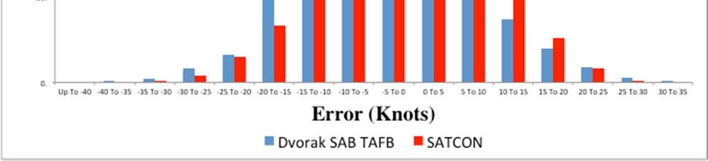
18 MSW (Kts) CIMSS AMSU CIMSS ADT CIRA AMSU CIMSS SSMIS SATCO N Subj. Dvorak (Operational) BIAS AVG ERRO R RMSE Homogenous sample of N=275 matches (except CIRA AMSU=187) with NHC recon-aided Best Track estimates. Subj. Dvorak is the average of subjective operational Dvorak estimates from TAFB and SAB. MSW (Kts) CIMSS AMSU CIMSS ADT CIMSS SSMIS SATCON BIAS AVG ERROR RMSE SATCON Performance compared to individual members N= 1467 (interpolated values)
19 SATCON Performance compared to individual members N= 1467 (interpolated values) MSW (Kts) CIMSS AMSU CIMSS ADT CIMSS SSMIS SATCON BIAS AVG ERROR RMSE
20
21 Future Work Loss of SSMIS F-16 and F-18 increases interpolation errors - use time-weighted weighting scheme that scales to 0 after 3 hours Investigate Bayesian approach Add S-NPP ATMS Potential new members (DAV, NRL MW Imager etc)

22 CIMSS TC Homepage
23 REFERENCES Brueske K. and C. Velden 2003: Satellite-Based Tropical Cyclone Intensity Estimation Using the NOAA-KLM Series Advanced Microwave Sounding Unit (AMSU). Monthly Weather Review Volume 131, Issue 4 (April 2003) pp Demuth J. and M. DeMaria, 2004: Evaluation of Advanced Microwave Sounding Unit Tropical- Cyclone Intensity and Size Estimation Algorithms. Journal of Applied Meteorology Volume 43, Issue 2 (February 2004) pp Herndon D. and C. Velden, 2004: Upgrades to the UW-CIMSS AMSU-based TC intensity algorithm. Preprints, 26th Conference on Hurricanes and Tropical Meteorology, Miami, FL, Amer. Meteor. Soc., Olander T. and C. Velden 2007: The Advanced Dvorak Technique: Continued Development of an Objective Scheme to Estimate Tropical Cyclone Intensity Using Geostationary Infrared Satellite Imagery. Wea. and Forecasting Volume 22, Issue 2 (April 2007) pp Velden C. et al., 2006: The Dvorak Tropical Cyclone Intensity Estimation Technique: A Satellite- Based Method that Has Endured for over 30 Years. Bulletin of the American Meteorological Society Volume 87, Issue 9 (September 2006) pp Wimmers, A., and C. Velden, 2010: Objectively Determining the Rotational Center of Tropical Cyclones in Passive Microwave Satellite Imagery. Submitted to JAMC.
24 REFERENCES Herndon, D., and C. Velden, J. D Hawkins 2012: Update on SATellite-based CONsensus (SATCON) Approach to TC Intensity Estimation. 30th Conference on Hurricanes and Tropical Meteorology. Ponte Vedra Beach, FL Herndon, D., and C. Velden, 2012: Estimating Tropical Cyclone Intensity Using the SSMIS and ATMS Sounders. 30th Conference on Hurricanes and Tropical Meteorology. Ponte Vedra Beach, FL Herndon, D., 2014: An Update on Tropical Cyclone Intensity Estimation from Satellite Microwave Sounders. 31st Conference on Hurricanes and Tropical Meteorology. San Diego, CA

25 Algorithm Western Pacific (WPAC) Validation N = 18 SATCON Vmax Dvorak Vmax BIAS AVG ERROR RMSE N=14 cases from TCS-08 double blind Dvorak experiment. 4 cases from ITOP 2010 Independent sample. Vmax validation in knots vs. BT. MSLP validation in hpa vs. recon. Neg. bias = method was too weak. Dvorak is average of operational centers (ITOP-2010) and five expert Dvorak analysts (TCS-08)
26 Analysis of Sat-Based TC Intensity Estimation in the WPAC 2008 and 2010 Comparison of All Satellite-based Estimates Vmax (Kts) N=14 Dvorak Consensus Oper Dvorak Consensus (w/koba) ADT w/mw CIMSS AMSU SATCON Bias Abs Error RMSE Positive Bias indicates method estimates are too strong
27 Analysis of Sat-Based TC Intensity Estimation in the WNP During TCS-08 Comparison of All Satellite-based Estimates MSLP (mb) N=14 Blind Dvorak Consensus Oper Dvorak Consensus (w/koba) ADT w/mw CIMSS AMSU SATCON Bias Abs Error RMSE Positive Bias indicates method estimates are too strong. 2mem SATCON RMSE= 4.7 Blind and Oper Dvorak conversion is Knaff/Zehr
28
Derrick Herndon and Chris Velden University of Wisconsin - Madison Cooperative Institute for Meteorological Satellite Studies
 Derrick Herndon and Chris Velden University of Wisconsin - Madison Cooperative Institute for Meteorological Satellite Studies Presented at International Workshop on Satellite Analysis of Tropical Cyclones
P4.1 CONSENSUS ESTIMATES OF TROPICAL CYCLONE INTENSITY USING MULTISPECTRAL (IR AND MW) SATELLITE OBSERVATIONS
 SATELLITE OBSERVATIONS") P4.1 CONSENSUS ESTIMATES OF TROPICAL CYCLONE INTENSITY USING MULTISPECTRAL (IR AND MW) SATELLITE OBSERVATIONS Christopher Velden* Derrick C. Herndon and James Kossin University of Wisconsin Cooperative
P4.1 CONSENSUS ESTIMATES OF TROPICAL CYCLONE INTENSITY USING MULTISPECTRAL (IR AND MW) SATELLITE OBSERVATIONS Christopher Velden* Derrick C. Herndon and James Kossin University of Wisconsin Cooperative
P1.21 Estimating TC Intensity Using the SSMIS and ATMS Sounders
 P1.21 Estimating TC Intensity Using the SSMIS and ATMS Sounders Derrick C. Herndon* and Christopher Velden University of Wisconsin Cooperative Institute for Meteorological Satellite Studies (UW-CIMSS)
Topic 2.3 OBJECTIVE TROPICAL CYCLONE INTENSITY ANALYSIS
 Topic 2.3 OBJECTIVE TROPICAL CYCLONE INTENSITY ANALYSIS Topic chairs: Rapporteurs: Elizabeth Ritchie and Chun-Chieh Wu Derrick Herndon and Chris Velden Cooperative Institute for Meteorological Satellite
The UW-CIMSS Advanced Dvorak Technique (ADT) : An Automated IR Method to Estimate Tropical Cyclone Intensity
 : An Automated IR Method to Estimate Tropical Cyclone Intensity") The UW-CIMSS Advanced (ADT) : An Automated IR Method to Estimate Tropical Cyclone Intensity Timothy Olander and Christopher Velden University of Wisconsin Madison, USA Cooperative Institute for Meteorological
The UW-CIMSS Advanced (ADT) : An Automated IR Method to Estimate Tropical Cyclone Intensity Timothy Olander and Christopher Velden University of Wisconsin Madison, USA Cooperative Institute for Meteorological
TC STRUCTURE GUIDANCE UPDATES
 TC STRUCTURE GUIDANCE UPDATES FROM NESDIS (CO)/CIRA Status and update for the multi-platform tropical cyclone wind analysis (MTCSWA) New microwave-sounder-based intensity and structure estimates New method
TROPICAL CYCLONE PROBABILITY PRODUCTS LECTURE 1C: WIND PROBABILITY
 TROPICAL CYCLONE PROBABILITY PRODUCTS LECTURE 1C: WIND PROBABILITY Russell L. Elsberry Materials provided by Mark DeMaria and John Knaff Outline What contributes most uncertainty to wind at a point? CIRA
Satellite-Derived Tropical Cyclone Structure and Intensity
 DISTRIBUTION STATEMENT A. Approved for public release; distribution is unlimited. Satellite-Derived Tropical Cyclone Structure and Intensity Jeffrey D. Hawkins Naval Research Laboratory 7 Grace Hopper
Observations Team: Satellite Observation Update. John Knaff NOAA/NESDIS Regional and Mesoscale Meteorology Branch
 Observations Team: Satellite Observation Update John Knaff NOAA/NESDIS Regional and Mesoscale Meteorology Branch 1 FY12 Satellite Milestones: i. CIRA/RAMMB continue maintaining and populating real-time
International TOVS Study Conference-XIV Proceedings. Liu zhe
 Analysis of typhoon rananim using ATOVS retrieval products Liu zhe Institute of Meteorology, PLA University of Science and Technology, Nanjing, China Han zhigang Zhao zengliang Beijing Institute of Applied
Ryo Oyama Meteorological Research Institute, Japan Meteorological Agency. Abstract
 Algorithm and validation of a tropical cyclone central pressure estimation method based on warm core intensity as observed using the Advanced Microwave Sounding Unit-A (AMSU-A) Ryo Oyama Meteorological
Chapter 10 Assessing Hurricane Intensity Using Satellites
 Chapter 10 Assessing Hurricane Intensity Using Satellites Mark DeMaria, John A. Knaff, and Raymond Zehr Abstract Tropical cyclones spend most of their life cycle over the tropical and subtropical oceans.
AN ANALYSIS OF TROPICAL CYCLONE INTENSITY ESTIMATES OF THE ADVANCED MICROWAVE SOUNDING UNIT (AMSU),
,") AN ANALYSIS OF TROPICAL CYCLONE INTENSITY ESTIMATES OF THE ADVANCED MICROWAVE SOUNDING UNIT (AMSU), 2005-2008 Corey Walton University of Miami, Coral Gables, FL INTRODUCTION Analysis and forecasts of tropical
AN ANALYSIS OF TROPICAL CYCLONE INTENSITY ESTIMATES OF THE ADVANCED MICROWAVE SOUNDING UNIT (AMSU), 2005-2008 Corey Walton University of Miami, Coral Gables, FL INTRODUCTION Analysis and forecasts of tropical
World Meteorological Organization. International Workshop on Satellite Analysis of Tropical Cyclones II (IWSATC-II)
") World Meteorological Organization International Workshop on Satellite Analysis of Tropical Cyclones II (IWSATC-II) Report and Recommendations Prepared by Andrew Burton and Christopher Velden (Co-Chairs)
World Meteorological Organization International Workshop on Satellite Analysis of Tropical Cyclones II (IWSATC-II) Report and Recommendations Prepared by Andrew Burton and Christopher Velden (Co-Chairs)
TC intensity estimation using Satellite data at JMA
 SECOND INTERNATIONAL WORKSHOP ON SATELLITE ANALYSIS OF TROPICAL CYCLONES (IWSATC-II) TC intensity estimation using Satellite data at JMA Topics: 1) Estimation of TC central pressure using Microwave Sounder
Microwave-TC intensity estimation. Ryo Oyama Meteorological Research Institute Japan Meteorological Agency
 Microwave-TC intensity estimation Ryo Oyama Meteorological Research Institute Japan Meteorological Agency Contents 1. Introduction 2. Estimation of TC Maximum Sustained Wind (MSW) using TRMM Microwave
Hurricane Structure: Theory and Application. John Cangialosi National Hurricane Center
 Hurricane Structure: Theory and Application John Cangialosi National Hurricane Center World Meteorological Organization Workshop Is this Tropical, Subtropical, or Extratropical? Subtropical Tropical Extratropical
SH RI Events. Influence From Patterns Of Different Scale
 SH072014 RI Events Influence From Patterns Of Different Scale RI Explanation * Rapid intensification, approximately an increase of 2 Dvorak T-numbers or 30 knots in 24 hours, frequently occurs in JTWC
Augmentation of Early Intensity Forecasting in Tropical Cyclones
 DISTRIBUTION STATEMENT A. Approved for public release; distribution is unlimited. Augmentation of Early Intensity Forecasting in Tropical Cyclones J. Scott Tyo College of Optical Sciences University of
A Pronounced Bias in Tropical Cyclone Minimum Sea Level Pressure Estimation Based on the Dvorak Technique
 15 A Pronounced Bias in Tropical Cyclone Minimum Sea Level Pressure Estimation Based on the Dvorak Technique JAMES P. KOSSIN AND CHRISTOPHER S. VELDEN Cooperative Institute for Meteorological Satellite
Satellite-Derived Tropical Cyclone Intensities and Structure Change (TCS-08 and ITOP)
") DISTRIBUTION STATEMENT A: Approved for public release; distribution is unlimited. Satellite-Derived Tropical Cyclone Intensities and Structure Change (TCS-08 and ITOP) Jeffrey D. Hawkins Naval Research
DISTRIBUTION STATEMENT A: Approved for public release; distribution is unlimited. Satellite-Derived Tropical Cyclone Intensities and Structure Change (TCS-08 and ITOP) Jeffrey D. Hawkins Naval Research
Kotaro Bessho Typhoon Research Department, Meteorological Research Institute, Nagamine 1-1, Tsukuba , Japan
 The Possibility of Determining Whether Organized Cloud Clusters Will Develop into Tropical Storms by Detecting Warm Core Structures from Advanced Microwave Sounding Unit Observations Kotaro Bessho Typhoon
Hurricane Structure: Theory and Diagnosis
 Hurricane Structure: Theory and Diagnosis 7 March, 2016 World Meteorological Organization Workshop Chris Landsea Chris.Landsea@noaa.gov National Hurricane Center, Miami Outline Structure of Hurricanes
4B.4 HURRICANE SATELLITE (HURSAT) DATA SETS: LOW EARTH ORBIT INFRARED AND MICROWAVE DATA
 DATA SETS: LOW EARTH ORBIT INFRARED AND MICROWAVE DATA") 4B.4 HURRICANE SATELLITE (HURSAT) DATA SETS: LOW EARTH ORBIT INFRARED AND MICROWAVE DATA Kenneth R. Knapp* NOAA - National Climatic Data Center, Asheville, North Carolina 1. INTRODUCTION Given the recent
4B.4 HURRICANE SATELLITE (HURSAT) DATA SETS: LOW EARTH ORBIT INFRARED AND MICROWAVE DATA Kenneth R. Knapp* NOAA - National Climatic Data Center, Asheville, North Carolina 1. INTRODUCTION Given the recent
AN UPDATE ON UW-CIMSS SATELLITE-DERIVED WIND DEVELOPMENTS
 AN UPDATE ON UW-CIMSS SATELLITE-DERIVED WIND DEVELOPMENTS Christopher Velden, Steve Wanzong and Paul Menzel University of Wisconsin - Cooperative Institute for Meteorological Satellite Studies 1225 West
Application of Satellite analysis in tropical cyclone of CMA
 2 nd International Workshop On Satellite Analysis of Tropical Cyclones (IWSATC-2) Satellite TC Analysis in Operations: Changes since IWSATC-1 17 February 2016 Honolulu, Hawaii, USA Application of Satellite
Improving Tropical Cyclone Forecasts by Assimilating Microwave Sounder Cloud-Screened Radiances and GPM precipitation measurements
 Improving Tropical Cyclone Forecasts by Assimilating Microwave Sounder Cloud-Screened Radiances and GPM precipitation measurements Hyojin Han a, Jun Li a, Mitch Goldberg b, Pei Wang a,c, Jinlong Li a,
Estimating Tropical Cyclone Intensity from Infrared Image Data
 690 W E A T H E R A N D F O R E C A S T I N G VOLUME 26 Estimating Tropical Cyclone Intensity from Infrared Image Data MIGUEL F. PIÑEROS College of Optical Sciences, The University of Arizona, Tucson,
Hurricane Sandy warm-core structure observed from advanced Technology Microwave Sounder
 GEOPHYSICAL RESEARCH LETTERS, VOL. 40, 3325 3330, doi:10.1002/grl.50626, 2013 Hurricane Sandy warm-core structure observed from advanced Technology Microwave Sounder Tong Zhu 1,2 and Fuzhong Weng 3 Received
Jun Mitch Goldberg %, Pei Timothy J. Schmit &, Jinlong Zhenglong and Agnes
 Progress on the assimilation of advanced IR sounder radiances in cloudy skies Jun Li @, Mitch Goldberg %, Pei Wang @#, Timothy J. Schmit &, Jinlong Li @, Zhenglong Li @, and Agnes Lim @ @CIMSS, University
Using satellite-based remotely-sensed data to determine tropical cyclone size and structure characteristics
 DISTRIBUTION STATEMENT A. Approved for public release; distribution is unlimited. Using satellite-based remotely-sensed data to determine tropical cyclone size and structure characteristics PI: Elizabeth
Remotely Sensed Tropical Cyclone Structure/Intensity Changes
 Remotely Sensed Tropical Cyclone Structure/Intensity Changes Jeffrey D. Hawkins Naval Research Laboratory Monterey, CA 93943-5502 (831) 656-4833, fax (831) 656-6006, hawkins@nrlmry.navy.mil Award #: N0001400WX20251
Comparative Study of Dvorak Analysis in the western North Pacific. Naohisa Koide and Shuji Nishimura Forecast Division, Japan Meteorological Agency
 Comparative Study of Dvorak Analysis in the western North Pacific Naohisa Koide and Shuji Nishimura Forecast Division, Japan Meteorological Agency 1. Introduction The United Nations Economic and Social
28th Conference on Hurricanes and Tropical Meteorology, 28 April 2 May 2008, Orlando, Florida.
 P2B. TROPICAL INTENSITY FORECASTING USING A SATELLITE-BASED TOTAL PRECIPITABLE WATER PRODUCT Mark DeMaria* NOAA/NESDIS/StAR, Fort Collins, CO Jeffery D. Hawkins Naval Research Laboratory, Monterey, CA
Recent Advances in the Processing, Targeting and Data Assimilation Applications of Satellite-Derived Atmospheric Motion Vectors (AMVs)
") Recent Advances in the Processing, Targeting and Data Assimilation Applications of Satellite-Derived Atmospheric Motion Vectors (AMVs) Howard Berger and Chris Velden Cooperative Institute for Meteorological
Recent Advances in the Processing, Targeting and Data Assimilation Applications of Satellite-Derived Atmospheric Motion Vectors (AMVs) Howard Berger and Chris Velden Cooperative Institute for Meteorological
On the assimilation of hyperspectral infrared sounder radiances in cloudy skies
 On the assimilation of hyperspectral infrared sounder radiances in cloudy skies Jun Li 1, Pei Wang 1, Zhenglong Li 1, Jinlong Li 1 and Mitchell D. Goldberg 2 1 Cooperative Institute for Meteorological
11A.1 PREDICTION OF TROPICAL CYCLONE TRACK FORECAST ERROR FOR HURRICANES KATRINA, RITA, AND WILMA
 11A.1 PREDICTION OF TROPICAL CYCLONE TRACK FORECAST ERROR FOR HURRICANES KATRINA, RITA, AND WILMA James S. Goerss* Naval Research Laboratory, Monterey, California 1. INTRODUCTION Consensus tropical cyclone
SIXTH INTERNATIONAL WORKSHOP on TROPICAL CYCLONES
 WMO/CAS/WWW SIXTH INTERNATIONAL WORKSHOP on TROPICAL CYCLONES Topic 1a : Special focus session on: "Tutorial on the use of satellite data to define tropical cyclone structure". Rapporteur: C.S. Velden
Introduction of the Hyperspectral Environmental Suite (HES) on GOES-R and beyond
 on GOES-R and beyond") Introduction of the Hyperspectral Environmental Suite (HES) on GOES-R and beyond 1 Timothy J. Schmit, 2 Jun Li, 3 James Gurka 1 NOAA/NESDIS, Office of Research and Applications, Advanced Satellite Products
Introduction of the Hyperspectral Environmental Suite (HES) on GOES-R and beyond 1 Timothy J. Schmit, 2 Jun Li, 3 James Gurka 1 NOAA/NESDIS, Office of Research and Applications, Advanced Satellite Products
International Best Track Archive for Climate Stewardship
 World Meteorological Organization International Best Track Archive for Climate Stewardship Third Workshop (IBTrACS-III) Report and Recommendations Prepared by Kenneth Knapp (Chair) HONOLULU, HAWAII, USA
NOAA/NESDIS Tropical Web Page with LEO Satellite Products and Applications for Forecasters
 NOAA/NESDIS Tropical Web Page with LEO Satellite Products and Applications for Forecasters Sheldon Kusselson National Oceanic and Atmospheric Administration (NOAA) National Environmental Satellite Data
9A.2 Tropical Cyclone Satellite Tutorial Online Through The COMET Program
 9A.2 Tropical Cyclone Satellite Tutorial Online Through The COMET Program Thomas F. Lee Steven D. Miller F. Joseph Turk Jeffrey D. Hawkins Naval Research Laboratory, Monterey CA Patrick Dills Sherwood
An Evaluation of Dvorak Technique Based Tropical Cyclone Intensity Estimates
 1362 W E A T H E R A N D F O R E C A S T I N G VOLUME 25 An Evaluation of Dvorak Technique Based Tropical Cyclone Intensity Estimates JOHN A. KNAFF NOAA/NESDIS/Regional and Mesoscale Meteorology Branch,
HIGH-RESOLUTION SATELLITE-DERIVED WIND FIELDS PE (035-71)
") HIGH-RESOLUTION SATELLITE-DERIVED WIND FIELDS PE 0602435 (035-71) Jeffrey D. Hawkins Naval Research Laboratory Monterey, CA 93943-5502 Ph (408) 656-4833/ Fax (408) 656-4769 hawkins@nrlmry.navy.mil LONG-TERM
HIGH-RESOLUTION SATELLITE-DERIVED WIND FIELDS PE 0602435 (035-71) Jeffrey D. Hawkins Naval Research Laboratory Monterey, CA 93943-5502 Ph (408) 656-4833/ Fax (408) 656-4769 hawkins@nrlmry.navy.mil LONG-TERM
Special Focus Session SF 1c CROWD SOURCING SCIENCE
 Special Focus Session SF 1c CROWD SOURCING SCIENCE Rapporteur: Chris Hennon University of North Carolina at Asheville 1 University Heights CPO #2450 Asheville, NC 28805 USA Email: chennon@unca.edu Phone:
The Dvorak tropical cyclone (TC) intensity estimation. technique has been the primary method of monitoring
 intensity estimation. technique has been the primary method of monitoring") THE DVORAK TROPICAL CYCLONE INTENSITY ESTIMATION TECHNIQUE A Satellite-Based Method that Has Endured for over 30 Years BY CHRISTOPHER VELDEN, BRUCE HARPER, FRANK WELLS, JOHN L. BEVEN II, RAY ZEHR, TIMOTHY
THE DVORAK TROPICAL CYCLONE INTENSITY ESTIMATION TECHNIQUE A Satellite-Based Method that Has Endured for over 30 Years BY CHRISTOPHER VELDEN, BRUCE HARPER, FRANK WELLS, JOHN L. BEVEN II, RAY ZEHR, TIMOTHY
The impact of assimilation of microwave radiance in HWRF on the forecast over the western Pacific Ocean
 The impact of assimilation of microwave radiance in HWRF on the forecast over the western Pacific Ocean Chun-Chieh Chao, 1 Chien-Ben Chou 2 and Huei-Ping Huang 3 1Meteorological Informatics Business Division,
9C.4 IMPROVING TROPICAL CYCLONE TRACK AND INTENSITY FORECASTING WITH JPSS IMAGER AND SOUNDER DATA
 9C.4 IMPROVING TROPICAL CYCLONE TRACK AND INTENSITY FORECASTING WITH JPSS IMAGER AND SOUNDER DATA Galina Chirokova * CIRA/CSU, Fort Collins, CO, USA Mark DeMaria NOAA/NWS/NCEP/NHC, Miami, FL, USA Robert
Florida State University Libraries
 Florida State University Libraries Electronic Theses, Treatises and Dissertations The Graduate School 2014 Estimate of Tropical Cyclone Parameters Based on Microwave Humidity Sounders Qi Shi Follow this
Topic 2: Cyclogenesis, Intensity and Intensity Change
 EIGHTH INTERNATIONAL WORKSHOP ON TROPICAL CYCLONES Topic 2: Cyclogenesis, Intensity and Intensity Change Topic chairs: Elizabeth A. Ritchie (UA) and Chun-Chieh Wu (NTU) Rapporteurs: Anantha Aiyyar (NCSU),
Forecast of hurricane track and intensity with advanced IR soundings
 Forecast of hurricane track and intensity with advanced IR soundings Jun Li @, Hui Liu #, Jinlong Li @, and Tim Schmit & @CIMSS/SSEC, University of Wisconsin-Madison #National Center for Atmospheric Research
Augmentation of Early Intensity Forecasting in Tropical Cyclones
 DISTRIBUTION STATEMENT A. Approved for public release; distribution is unlimited. Augmentation of Early Intensity Forecasting in Tropical Cyclones J. Scott Tyo College of Optical Sciences University of
Impact of assimilating the VIIRS-based CrIS cloudcleared radiances on hurricane forecasts
 Impact of assimilating the VIIRS-based CrIS cloudcleared radiances on hurricane forecasts Jun Li @, Pei Wang @, Jinlong Li @, Zhenglong Li @, Jung-Rim Lee &, Agnes Lim @, Timothy J. Schmit #, and Mitch
Development of Tropical cyclone objective analysis technique based on FY serial satellite data
 2 nd International Workshop On Satellite Analysis of Tropical Cyclones (IWSATC-2) Update on Objective Satellite-Based TC Analysis Methods 18 February 2016 Honolulu, Hawaii, USA Development of Tropical
P1.23 HISTOGRAM MATCHING OF ASMR-E AND TMI BRIGHTNESS TEMPERATURES
 P1.23 HISTOGRAM MATCHING OF ASMR-E AND TMI BRIGHTNESS TEMPERATURES Thomas A. Jones* and Daniel J. Cecil Department of Atmospheric Science University of Alabama in Huntsville Huntsville, AL 1. Introduction
THE PHYSICAL processes associated with tropical cyclone
 826 IEEE GEOSCIENCE AND REMOTE SENSING LETTERS, VOL. 7, NO. 4, OCTOBER 2010 Detecting Tropical Cyclone Genesis From Remotely Sensed Infrared Image Data Miguel F. Piñeros, Elizabeth A. Ritchie, and J. Scott
7B.1 An Overview of the International Best Track Archive for Climate Stewardship (IBTrACS) Michael C. Kruk* STG Inc., Asheville, North Carolina
 Michael C. Kruk* STG Inc., Asheville, North Carolina") 7B.1 An Overview of the International Best Track Archive for Climate Stewardship (IBTrACS) Michael C. Kruk* STG Inc., Asheville, North Carolina Kenneth R. Knapp, David H. Levinson, Howard J. Diamond NOAA
7B.1 An Overview of the International Best Track Archive for Climate Stewardship (IBTrACS) Michael C. Kruk* STG Inc., Asheville, North Carolina Kenneth R. Knapp, David H. Levinson, Howard J. Diamond NOAA
11A.3 The Impact on Tropical Cyclone Predictions of a Major Upgrade to the Met Office Global Model
 11A.3 The Impact on Tropical Cyclone Predictions of a Major Upgrade to the Met Office Global Model Julian T. Heming * Met Office, Exeter, UK 1. BACKGROUND TO MODEL UPGRADE The last major upgrade to the
Using Flight Level Data to Improve Historical Tropical Cyclone Databases
 Using Flight Level Data to Improve Historical Tropical Cyclone Databases Dr. Jonathan L. Vigh Shanghai Typhoon Institute 12 July 2018 NCAR is sponsored by the National Science Foundation On the Need for
Revisiting the maximum intensity of recurving tropical cyclones
 INTERNATIONAL JOURNAL OF CLIMATOLOGY Int. J. Climatol. 29: 827 837 (2009) Published online 26 August 2008 in Wiley InterScience (www.interscience.wiley.com).1746 Revisiting the maximum intensity of recurving
The warm-core structure of Super Typhoon Rammasun derived by FY-3C microwave temperature sounder measurements
 ATMOSPHERIC SCIENCE LETTERS Atmos. Sci. Let. 17: 432 43 (21) Published online 22 June 21 in Wiley Online Library (wileyonlinelibrary.com) DOI: 1.12/asl.75 The warm-core structure of Super Typhoon Rammasun
Atmospheric Motions Derived From Space Based Measurements: A Look To The Near Future. James F.W. Purdom
 Atmospheric Motions Derived From Space Based Measurements: A Look To The Near Future James F.W. Purdom Director, Office of Research and Applications NOAA/NESDIS 1. Introduction This short note addresses
A Tropical Cyclone with a Very Large Eye
 JANUARY 1999 PICTURES OF THE MONTH 137 A Tropical Cyclone with a Very Large Eye MARK A. LANDER University of Guam, Mangilao, Guam 9 September 1997 and 2 March 1998 1. Introduction The well-defined eye
Feel free to ask for help also, we will try our best to answer your question or at least direct you to where you can find the answer.
 Page 1 Objectives: Become familiar with online resources and image searching tools Interpret different types of satellite imagery Learn about the variety of different types of TCs Part 1: Browse available
Tropical Cyclone Surface Wind Structure and Wind Pressure Relationships. 15 November 2010 IWTC VII, La Reunion, France 1
 Tropical Cyclone Surface Wind Structure and Wind Pressure Relationships 15 November 2010 IWTC VII, La Reunion, France 1 Acknowledgements Dan Brown (NOAA/NHC, Miami), Joe Courtney (BoM, Perth) Derrick Herndon
JTWC's Use of TRMM in Typhoon Forecast Operations
 Use of TRMM in Typhoon Forecast Operations JTWC's Use of TRMM in Typhoon Forecast Operations Slide 1/24 Use of TRMM in Typhoon Forecast Operations Slide 2/24 Opening Comments The current microwave satellite
An Example of Temperature Structure Differences in Two Cyclone Systems Derived from the Advanced Microwave Sounder Unit
 476 WEATHER AND FORECASTING VOLUME 15 An Example of Temperature Structure Differences in Two Cyclone Systems Derived from the Advanced Microwave Sounder Unit JOHN A. KNAFF Cooperative Institute for Research
Cyclone Center. Using Citizen Science to Reconcile Global Tropical Cyclone Intensity. Chris Hennon University of North Carolina at Asheville, USA
 Cyclone Center Using Citizen Science to Reconcile Global Tropical Cyclone Intensity Chris Hennon University of North Carolina at Asheville, USA Ken Knapp, Carl Schreck, Scott Stevens, Jim Kossin, Peter
Operational and Statistical Prediction of Rapid Intensity Change. Mark DeMaria and Eric Blake, NCEP/NHC John Kaplan, AOML/HRD
 Operational and Statistical Prediction of Rapid Intensity Change Mark DeMaria and Eric Blake, NCEP/NHC John Kaplan, AOML/HRD Outline Evaluation of NHC forecasts and deterministic models for rapid intensification
ASSIMILATION OF SATELLITE DERIVED WINDS INTO THE COMMUNITY HURRICANE MODELING SYSTEM (CHUMS) AT PENN STATE. Jenni L. Evans 1
 AT PENN STATE. Jenni L. Evans 1") ASSIMILATION OF SATELLITE DERIVED WINDS INTO THE COMMUNITY HURRICANE MODELING SYSTEM (CHUMS) AT PENN STATE Jenni L. Evans 1 Department of Meteorology, The Pennsylvania State University 503 Walker Building,
ASSIMILATION OF SATELLITE DERIVED WINDS INTO THE COMMUNITY HURRICANE MODELING SYSTEM (CHUMS) AT PENN STATE Jenni L. Evans 1 Department of Meteorology, The Pennsylvania State University 503 Walker Building,
Comparison of Three Tropical Cyclone Intensity Datasets
 NO.1 YU Hui, HU Chunmei and JIANG Leyi 121 Comparison of Three Tropical Cyclone Intensity Datasets YU Hui 1,2 ( ), HU Chunmei 3 ( ), and JIANG Leyi 1,2 ( ) 1 Shanghai Typhoon Institute, CMA, Shanghai 200030
The Dvorak Technique
 Dvorak Technique Title Slide The Dvorak Technique JACK BEVEN NATIONAL HURRICANE CENTER WHERE AMERICA S CLIMATE AND WEATHER SERVICES BEGIN What is the Dvorak Technique? A statistical method for estimating
Tropical Cyclone Mesoscale Data Assimilation
 Tropical Cyclone Mesoscale Data Assimilation Sharan Majumdar (RSMAS / U. Miami) Chris Velden (CIMSS / U. Wisconsin) Acknowledgments: Ryan Torn (SUNY at Albany), Altug Aksoy and Tomislava Vukicevic (NOAA/AOML/HRD)
Future Opportunities of Using Microwave Data from Small Satellites for Monitoring and Predicting Severe Storms
 Future Opportunities of Using Microwave Data from Small Satellites for Monitoring and Predicting Severe Storms Fuzhong Weng Environmental Model and Data Optima Inc., Laurel, MD 21 st International TOV
NWS and Navy Plans for the ATCF and AWIPS2
 NWS and Navy Plans for the ATCF and AWIPS2 Mark DeMaria, Craig A. Mattocks, Christopher Mello, Michael Brennan and Monica Bozeman NOAA/NWS National Hurricane Center, Miami, FL Charles R. Sampson and Michael
Structural and Intensity Changes of Concentric Eyewall Typhoons in the Western North Pacific Basin
 2632 M O N T H L Y W E A T H E R R E V I E W VOLUME 141 Structural and Intensity Changes of Concentric Eyewall Typhoons in the Western North Pacific Basin YI-TING YANG AND HUNG-CHI KUO Department of Atmospheric
Marine Meteorology Division, Naval Research Laboratory, Monterey, CA. Tellus Applied Sciences, Inc.
 Nancy Baker 1, Rolf Langland 1, Pat Pauley 1, Liang Xu 1 Dagmar Merkova 2,3 and Ron Gelaro 2 Chris Velden 4 1 Marine Meteorology Division, Naval Research Laboratory, Monterey, CA 2 Global Modeling and
Report on CIMSS Participation in the Utility of GOES-R Instruments for Hurricane Data Assimilation and Forecasting
 Report on CIMSS Participation in the Utility of GOES-R Instruments for Hurricane Data Assimilation and Forecasting Award Number: NA10NES4400010 Award Period: 06/01/2010-05/31/2014 Program Office: NESDIS
Western North Pacific Typhoons with Concentric Eyewalls
 3758 M O N T H L Y W E A T H E R R E V I E W VOLUME 137 Western North Pacific Typhoons with Concentric Eyewalls HUNG-CHI KUO Department of Atmospheric Sciences, National Taiwan University, Taipei, Taiwan
AMERICAN METEOROLOGICAL SOCIETY
 AMERICAN METEOROLOGICAL SOCIETY Bulletin of the American Meteorological Society EARLY ONLINE RELEASE This is a preliminary PDF of the author-produced manuscript that has been peer-reviewed and accepted
Understanding the Microphysical Properties of Developing Cloud Clusters During TCS-08
 DISTRIBUTION STATEMENT A. Approved for public release; distribution is unlimited. Understanding the Microphysical Properties of Developing Cloud Clusters During TCS-08 PI: Elizabeth A. Ritchie Department
Understanding the Microphysical Properties of Developing Cloud Clusters during TCS-08
 DISTRIBUTION STATEMENT A: Approved for public release; distribution is unlimited. Understanding the Microphysical Properties of Developing Cloud Clusters during TCS-08 PI: Elizabeth A. Ritchie Department
The Development of Hyperspectral Infrared Water Vapor Radiance Assimilation Techniques in the NCEP Global Forecast System
 The Development of Hyperspectral Infrared Water Vapor Radiance Assimilation Techniques in the NCEP Global Forecast System James A. Jung 1, John F. Le Marshall 2, Lars Peter Riishojgaard 3, and John C.
SMAP Winds. Hurricane Irma Sep 5, AMS 33rd Conference on Hurricanes and Tropical Meteorology Ponte Vedra, Florida, 4/16 4/20, 2018
 Intensity and Size of Strong Tropical Cyclones in 2017 from NASA's SMAP L-Band Radiometer Thomas Meissner, Lucrezia Ricciardulli, Frank Wentz, Remote Sensing Systems, Santa Rosa, USA Charles Sampson, Naval
The Impacts on Extended-Range Predictability of Midlatitude Weather Patterns due to Recurving Tropical Cyclones
 The Impacts on Extended-Range Predictability of Midlatitude Weather Patterns due to Recurving Tropical Cyclones Patrick A. Harr and Heather M. Archambault Naval Postgraduate School, Monterey, CA Hurricane
2017 Year in review: JTWC TC Activity, Forecast Challenges, and Developmental Priorities
 2017 Year in review: JTWC TC Activity, Forecast Challenges, and Developmental Priorities Mean Annual TC Activity????????? Hurricane Forecast Improvement Program Annual Review 8-9 NOV 2017 Brian Strahl,
Why There Is Weather?
 Lecture 6: Weather, Music Of Our Sphere Weather and Climate WEATHER The daily fluctuations in atmospheric conditions. The atmosphere on its own can produce weather. (From Understanding Weather & Climate)
The Transition of Atmospheric Infrared Sounder Total Ozone Products to Operations
 The Transition of Atmospheric Infrared Sounder Total Ozone Products to Operations Emily Berndt 1, Bradley Zavodsky 2, Gary Jedlovec 2 1 NASA Postdoctoral Program Marshall Space Flight Center, Huntsville,
KN.3: Tropical Cyclone Surface Wind Structure and Wind-Pressure Relationships
 WWW/CAS/WWW SEVENTH INTERNATIONAL WORKSHOP ON TROPICAL CYCLONES KN.3: Tropical Cyclone Surface Wind Structure and Wind-Pressure Relationships Keynote Co-chairs: John A. Knaff NOAA/NESDIS, Regional and
The Operational Challenges of Forecasting TC Intensity Change in the Presence of Dry Air and Strong Vertical Shear
 The Operational Challenges of Forecasting TC Intensity Change in the Presence of Dry Air and Strong Vertical Shear Jamie R. Rhome,* and Richard D. Knabb NOAA/NWS/NCEP/Tropical Prediction Center/National
Detecting Tropical Cyclone Structural Change with the TRMM Precipitation Radar (PR) and Advanced Microwave Sounding Unit (AMSU)
 and Advanced Microwave Sounding Unit (AMSU)") Detecting Tropical Cyclone Structural Change with the TRMM Precipitation Radar (PR) and Advanced Microwave Sounding Unit (AMSU) Stephen R. Guimond 1 *, F. Joseph Turk 2, Clay B. Blankenship 2 and Jeffrey
Detecting Tropical Cyclone Structural Change with the TRMM Precipitation Radar (PR) and Advanced Microwave Sounding Unit (AMSU) Stephen R. Guimond 1 *, F. Joseph Turk 2, Clay B. Blankenship 2 and Jeffrey
ESTIMATION OF THE SEA SURFACE WIND IN THE VICINITY OF TYPHOON USING HIMAWARI-8 LOW-LEVEL AMVS
 Proceedings for the 13 th International Winds Workshop 27 June - 1 July 2016, Monterey, California, USA ESTIMATION OF THE SEA SURFACE WIND IN THE VICINITY OF TYPHOON USING HIMAWARI-8 LOW-LEVEL AMVS Kenichi
A NEW SAR RETRIEVAL METHOD FOR HURRICANE WIND PARAMETERS
 A NEW SAR RETRIEVAL METHOD FOR HURRICANE WIND PARAMETERS Antonio Reppucci, Susanne lehner, Johannes Schulz-Stellenfleth German Aerospace Center (DLR) Oberpfaffenhofen 82234 Wessling, Germany. Hurricane
Examination of Tropical Cyclogenesis using the High Temporal and Spatial Resolution JRA-25 Dataset
 Examination of Tropical Cyclogenesis using the High Temporal and Spatial Resolution JRA-25 Dataset Masato Sugi Forecast Research Department, Meteorological Research Institute, Japan Correspondence: msugi@mri-jma.go.jp
Lecture 19: Operational Remote Sensing in Visible, IR, and Microwave Channels
 MET 4994 Remote Sensing: Radar and Satellite Meteorology MET 5994 Remote Sensing in Meteorology Lecture 19: Operational Remote Sensing in Visible, IR, and Microwave Channels Before you use data from any
Extratropical transition of tropical cyclones: Operational forecasting challenges. Matthew Kucas Joint Typhoon Warning Center Pearl Harbor, HI, USA
 Extratropical transition of tropical cyclones: Operational forecasting challenges Matthew Kucas Joint Typhoon Warning Center Pearl Harbor, HI, USA Outline Motivation for discussion Brief overview of tropical
NHC Ensemble/Probabilistic Guidance Products
 NHC Ensemble/Probabilistic Guidance Products Michael Brennan NOAA/NWS/NCEP/NHC Mark DeMaria NESDIS/STAR HFIP Ensemble Product Development Workshop 21 April 2010 Boulder, CO 1 Current Ensemble/Probability
ADJONT-BASED ANALYSIS OF OBSERVATION IMPACT ON TROPICAL CYCLONE INTENSITY FORECASTS
 7A.3 ADJONT-BASED ANALYSIS OF OBSERVATION IMPACT ON TROPICAL CYCLONE INTENSITY FORECASTS Brett T. Hoover* and Chris S. Velden Cooperative Institute for Meteorological Satellite Studies, Space Science and
Assessment of AHI Level-1 Data for HWRF Assimilation
 Assessment of AHI Level-1 Data for HWRF Assimilation Xiaolei Zou 1 and Fuzhong Weng 2 1 Earth System Science Interdisciplinary Center, University of Maryland, College Park, Maryland 2 Satellite Meteorology
The Impact of Satellite Atmospheric Motion Vectors in the U.S. Navy Global Data Assimilation System NWP Results
 The Impact of Satellite Atmospheric Motion Vectors in the U.S. Navy Global Data Assimilation System NWP Results Nancy L. Baker 1, Rolf Langland 1, Patricia M. Pauley 1, Liang Xu 1, Dagmar Merkova 2,3,