Operational and Statistical Prediction of Rapid Intensity Change. Mark DeMaria and Eric Blake, NCEP/NHC John Kaplan, AOML/HRD
|
|
|
- William Page
- 5 years ago
- Views:
Transcription


1 Operational and Statistical Prediction of Rapid Intensity Change Mark DeMaria and Eric Blake, NCEP/NHC John Kaplan, AOML/HRD
2 Outline Evaluation of NHC forecasts and deterministic models for rapid intensification cases Operational methods for anticipating rapid intensification The SHIPS Rapid Intensification Index


3 Hurricane Marie 2014 Aug UTC to Aug UTC
4 Distribution of 24 hr Intensity Changes Atlantic From Kaplan et al (2010) WaF
5 RI Verification Procedure Sample Operational Forecasts Tropical/Subtropical cases Land cases removed Four intensity change thresholds 20, 30, 40 and 50 kt Five forecast periods 0-24, 24-48, 48-72, 72-96, hr Forecast Techniques OFCL, DSHP, LGEM, GHMI, HWFI Question 1: Do techniques forecast RI? Question 2: How accurate are RI forecasts? Probability of Detection = % of observed RI cases correctly forecasted False Alarm Ratio = % of RI forecasts that were not RI cases
6 Percentage of AL Cases with RI
7 Percentage of EP Cases with RI
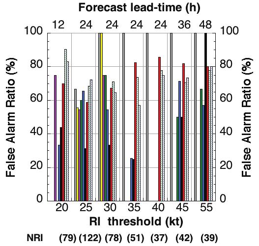
8 POD and FAR for 0-24 hr 30 kt Threshold Atlantic East Pacific
9 Main Tools for RI Forecasting at NHC SHIPS-RI Index 8 predictors used to estimate RI probabilities Global model predictions/fields Favorable characteristic upper-level patterns and/or the models showing sharp intensification. Microwave images Research has shown that a closed ring on the 37 ghz channel with other favorable environment factors greatly increases the chance of RI.
 0 6 12 18 24 36 48 60 72 84 96 108 120 V (KT) NO LAND 70 79 86 92 97 104 108 111 111 107 107 101 93 V (KT) LAND 70 79 86 92 97 104 108 111 111 107 107 101 93 V (KT) LGE")
 : 6.0 Range: 15.2 to 1.6 Scaled/Wgted Val: 0.7/ 0.8 D200 (10**7s-1) : 70.0 Range:-10.0 to 129.0 Scaled/Wgted Val: 0.6/ 0.4 POT = MPI-VMAX (KT) : 96.")
10 RI Guidance Hurricane Rick ( East Pacific) (output below is available in real-time) * EAST PACIFIC SHIPS INTENSITY FORECAST * * GOES DATA AVAILABLE * * OHC DATA AVAILABLE * * RICK EP /16/09 18 UTC * TIME (HR) V (KT) NO LAND V (KT) LAND V (KT) LGE mod ** 2009 E. Pacific RI INDEX EP RICK 10/16/09 18 UTC ** ( 30 KT OR MORE MAX WIND INCREASE IN NEXT 24 HR) 12 HR PERSISTENCE (KT): 20.0 Range:-20.0 to 35.0 Scaled/Wgted Val: 0.7/ MB SHEAR (KT) : 6.0 Range: 15.2 to 1.6 Scaled/Wgted Val: 0.7/ 0.8 D200 (10**7s-1) : 70.0 Range:-10.0 to Scaled/Wgted Val: 0.6/ 0.4 POT = MPI-VMAX (KT) : 96.7 Range: 46.6 to Scaled/Wgted Val: 0.6/ MB REL HUM (%): 79.4 Range: 64.0 to 88.0 Scaled/Wgted Val: 0.6/ 0.2 % area w/pixels <-30 C: 98.0 Range: 26.0 to Scaled/Wgted Val: 1.0/ 0.5 STD DEV OF IR BR TEMP : 8.3 Range: 35.4 to 2.7 Scaled/Wgted Val: 0.8/ 1.3 Heat content (KJ/cm2) : 46.8 Range: 4.0 to 67.0 Scaled/Wgted Val: 0.7/ 0.4 Prob of RI for 25 kt RI threshold= 78% is 6.8 times the sample mean(11.5%) Prob of RI for 30 kt RI threshold= 71% is 9.3 times the sample mean( 7.7%) Prob of RI for 35 kt RI threshold= 66% is 12.6 times the sample mean( 5.2%)


11 Rapid Intensification Hurricane Rick ( East Pacific) NHC FORECAST POSITIONS AND MAX WINDS INITIAL 16/2100Z 13.0N 100.0W 75 KT 12HR VT 17/0600Z 13.2N 101.3W 90 KT 24HR VT 17/1800Z 13.7N 103.3W 105 KT 36HR VT 18/0600Z 14.3N 105.8W 115 KT 48HR VT 18/1800Z 15.0N 108.1W 125 KT 72HR VT 19/1800Z 16.5N 111.5W 120 KT 96HR VT 20/1800Z 18.5N 113.0W 105 KT 120HR VT 21/1800Z 20.5N 113.0W 85 KT 70 kt 135 kt 24 hrs

12 Difficulty with Rapid Intensity Change First round of RI (intensification to Cat 1 hurricane) relatively well anticipated in official NHC forecasts Second more extreme instance of RI was not well forecast Rapid weakening after peak intensity not forecast well either

13 GFS SLP/200 mb winds Marie

14
, John Knaff (NOAA/NESDIS), Jeremy Solbrig (NRL), Jun Zhang (U. Miami/HRD), Jack Dostalek (CIRA), Jeffrey Hawkins (NRL), Evan Kalina (U.")
15 John Kaplan (NOAA/HRD), Mark DeMaria (NOAA/NHC), James Kossin (NOAA/NCDC), Christopher Rozoff (CIMSS), Charles Sampson(NRL), Christopher Velden (CIMSS), Joseph Cione (NOAA/ESRL/HRD), Jason Dunion (U. Miami/HRD), John Knaff (NOAA/NESDIS), Jeremy Solbrig (NRL), Jun Zhang (U. Miami/HRD), Jack Dostalek (CIRA), Jeffrey Hawkins (NRL), Evan Kalina (U. Colorado), Paul Leighton (NOAA/HRD) Acknowledgements: Financial support provided by the NOAA/OAR USWRP Joint Hurricane Testbed and NOAA/NESDIS GOES-R Proving Ground programs.

16 Background Deterministic forecasts of RI have generally been unreliable. Statistically based model for estimating the probability of RI for a 24-h lead time (i.e., t=0 to t=24-h) using SHIPS environmental predictors (SHIPS- RII) was developed and implemented operationally at the NHC in 2004 (Kaplan and DeMaria 2003). Discriminant analysis version of the SHIPS-RII that employed additional environmental and new inner-core GOES-IR predictors was subsequently developed and became operational at the NHC in 2008 (Kaplan et al. 2010). Recent research has been conducted to improve statistical RI prediction by developing enhanced versions of the SHIPS-RII, Logistic regression, Bayesian, and Consensus RI models (Rozoff and Kossin 2011) for lead times of 12-h, 24-h, 36-h and 48-h.
 (-) D200 200-hPA divergence from 0-1000 km radius (time-avg.")
17 Predictors used in new enhanced SHIPS-RII Predictor Definition DV12 Previous 12-h intensity change (+) SHEAR hPA vertical shear from km radius with vortex removed (time-avg.) (-) D hPA divergence from km radius (time-avg.) (+) TPW Percent area with TPW < 45 mm within 500 km radius 90 up-shear (t=0 h) (-) PC2 Second principle component of GOES-IR imagery within 440 km radius (t= 0 h) (-) SDBT Std. dev. of km GOES-IR brightness temperatures (t= 0 h) (-) MPI Potential intensity (Current intensity maximum potential intensity) (time-avg.) (+) OHC Oceanic heat content (time-avg.) (+) ICDA Inner-core dry air predictor (time-avg.) (-) VMX0 Maximum sustained wind (t=0 h) (+)


18 SHIPS-RI Predictor Relative Weights Atlantic E. Pacific
19 Verification Methodology Cross-validated leave one-year out versions of each of the Atlantic and E. Pacific RI models (SHIPS, Bayesian, Logistic regression, Consensus) were derived for all RI thresholds for the 10-year sample. The new independent cross-validated RI models were rerun for all cases from utilizing the operational GFS forecast fields and NHC storm input data archived for that 10-year period. The cross-validated independent forecasts were verified for all tropical and subtropical over-water cases as determined based upon NHC best track data.


20 Skill of the probabilistic independent RI model rerun forecasts Atlantic E. Pacific


21 Reliability of the probabilistic consensus RI model rerun forecasts Atlantic E. Pacific
22 Sample consensus RI model Atlantic basin rerun forecasts Wilma (2005) Michael (2012)
23 Deterministic RI verification All operational model, NHC, and consensus RI model rerun forecasts were verified for a homogenous sample of over-water tropical and subtropical forecast cases for the period RI consensus model forecast probability cutoffs of ~3-3.5 times the climatological probability of RI used to predict RI determined based upon rerun forecasts following the methodology described in Kaplan et al (2010). Operational intensity model and NHC OFCL forecasts determined to predict RI if forecasted intensity > RI threshold for a given case.


24 Atlantic ( ) deterministic RI model forecast skill


25 E. Pacific ( ) deterministic RI forecast skill


26 Improvements in NHC OFCL RI forecast skill
 New HFIP diagnostics Large-scale Aircraft data (Rogers et al.")
27 Future statistical RI model improvements NHC Structural information (Carrasco et al. 2014) Lightning data (DeMaria et al. 2012) Microwave satellite data (Rozoff et al. 2014) New HFIP diagnostics Large-scale Aircraft data (Rogers et al. 2014) Consensus methods ECMWF version of RII Other statistical techniques Logistic regression, Bayesian

28 Extra slides
29 Percentile thresholds associated with the corresponding RI intensity change for the Atlantic/Eastern North Pacific basins RI thresholds ( ). RI threshold N NRI Probability of RI (kt) (%) / / / / / / / / / / / / / / / / / / / / /94.0
30 Sample Consensus RI model E. Pacific basin rerun forecasts Rick (2009) Flossie (2007)
NHC Ensemble/Probabilistic Guidance Products
 NHC Ensemble/Probabilistic Guidance Products Michael Brennan NOAA/NWS/NCEP/NHC Mark DeMaria NESDIS/STAR HFIP Ensemble Product Development Workshop 21 April 2010 Boulder, CO 1 Current Ensemble/Probability
A Revised Tropical Cyclone Rapid Intensification Index for the Atlantic and Eastern North Pacific Basins
 220 W E A T H E R A N D F O R E C A S T I N G VOLUME 25 A Revised Tropical Cyclone Rapid Intensification Index for the Atlantic and Eastern North Pacific Basins JOHN KAPLAN NOAA/AOML/Hurricane Research
Improving Tropical Cyclone Guidance Tools by Accounting for Variations in Size
 Improving Tropical Cyclone Guidance Tools by Accounting for Variations in Size John A. Knaff 1, Mark DeMaria 1, Scott P. Longmore 2 and Robert T. DeMaria 2 1 NOAA Center for Satellite Applications and
Forecast Challenges of the 2017 Hurricane Season and NHC Priorities for 2018
 Forecast Challenges of the 2017 Hurricane Season and NHC Priorities for 2018 Michael J. Brennan, Mark DeMaria, Eric S. Blake, Richard J. Pasch, Andrew Penny Annual HFIP Meeting 8 November 2017 Outline
28th Conference on Hurricanes and Tropical Meteorology, 28 April 2 May 2008, Orlando, Florida.
 P2B. TROPICAL INTENSITY FORECASTING USING A SATELLITE-BASED TOTAL PRECIPITABLE WATER PRODUCT Mark DeMaria* NOAA/NESDIS/StAR, Fort Collins, CO Jeffery D. Hawkins Naval Research Laboratory, Monterey, CA
Satellite Applications to Hurricane Intensity Forecasting
 Satellite Applications to Hurricane Intensity Forecasting Christopher J. Slocum - CSU Kate D. Musgrave, Louie D. Grasso, and Galina Chirokova - CIRA/CSU Mark DeMaria and John Knaff - NOAA/NESDIS Center
A Deterministic Rapid Intensification Aid
 AUGUST 2011 S A M P S O N E T A L. 579 A Deterministic Rapid Intensification Aid CHARLES R. SAMPSON Naval Research Laboratory, Monterey, California JOHN KAPLAN NOAA/AOML/Hurricane Research Division, Miami,
A Reformulation of the Logistic Growth Equation Model (LGEM) for Ensemble and Extended Range Intensity Prediction
 for Ensemble and Extended Range Intensity Prediction") A Reformulation of the Logistic Growth Equation Model (LGEM) for Ensemble and Extended Range Intensity Prediction Mark DeMaria NOAA/NESDIS, Fort Collins, CO Andrea Schumacher and Kate Musgrave CIRA/CSU,
A Reformulation of the Logistic Growth Equation Model (LGEM) for Ensemble and Extended Range Intensity Prediction Mark DeMaria NOAA/NESDIS, Fort Collins, CO Andrea Schumacher and Kate Musgrave CIRA/CSU,
Observations Team: Satellite Observation Update. John Knaff NOAA/NESDIS Regional and Mesoscale Meteorology Branch
 Observations Team: Satellite Observation Update John Knaff NOAA/NESDIS Regional and Mesoscale Meteorology Branch 1 FY12 Satellite Milestones: i. CIRA/RAMMB continue maintaining and populating real-time
Motivation & Goal. We investigate a way to generate PDFs from a single deterministic run
 Motivation & Goal Numerical weather prediction is limited by errors in initial conditions, model imperfections, and nonlinearity. Ensembles of an NWP model provide forecast probability density functions
The Evolution and Use of Objective Forecast Guidance at NHC
 The Evolution and Use of Objective Forecast Guidance at NHC James L. Franklin Branch Chief, Hurricane Specialist Unit National Hurricane Center 2010 EMC/MMM/DTC Workshop 1 Hierarchy of TC Track Models
Topic 2: Cyclogenesis, Intensity and Intensity Change
 EIGHTH INTERNATIONAL WORKSHOP ON TROPICAL CYCLONES Topic 2: Cyclogenesis, Intensity and Intensity Change Topic chairs: Elizabeth A. Ritchie (UA) and Chun-Chieh Wu (NTU) Rapporteurs: Anantha Aiyyar (NCSU),
A Preliminary Exploration of the Upper Bound of Tropical Cyclone Intensification
 A Preliminary Exploration of the Upper Bound of Tropical Cyclone Intensification Jonathan L. Vigh (NCAR/RAL) Kerry Emanuel (MIT) Mrinal K. Biswas (NCAR/RAL) Eric A. Hendricks (Naval Postgraduate School)
GFDL Hurricane Model Ensemble Performance During the 2012 Hurricane Season
 GFDL Hurricane Model Ensemble Performance During the 2012 Hurricane Season Tim Marchok (NOAA / GFDL) Matt Morin (DRC HPTG / GFDL) Morris Bender (NOAA / GFDL) HFIP Team Telecon 12 December 2012 Acknowledgments:
A Simplified Dynamical System for Tropical Cyclone Intensity Prediction
 68 M O N T H L Y W E A T H E R R E V I E W VOLUME 137 A Simplified Dynamical System for Tropical Cyclone Intensity Prediction MARK DEMARIA NOAA/NESDIS, Fort Collins, Colorado (Manuscript received 27 December
P4.1 CONSENSUS ESTIMATES OF TROPICAL CYCLONE INTENSITY USING MULTISPECTRAL (IR AND MW) SATELLITE OBSERVATIONS
 SATELLITE OBSERVATIONS") P4.1 CONSENSUS ESTIMATES OF TROPICAL CYCLONE INTENSITY USING MULTISPECTRAL (IR AND MW) SATELLITE OBSERVATIONS Christopher Velden* Derrick C. Herndon and James Kossin University of Wisconsin Cooperative
P4.1 CONSENSUS ESTIMATES OF TROPICAL CYCLONE INTENSITY USING MULTISPECTRAL (IR AND MW) SATELLITE OBSERVATIONS Christopher Velden* Derrick C. Herndon and James Kossin University of Wisconsin Cooperative
9C.4 IMPROVING TROPICAL CYCLONE TRACK AND INTENSITY FORECASTING WITH JPSS IMAGER AND SOUNDER DATA
 9C.4 IMPROVING TROPICAL CYCLONE TRACK AND INTENSITY FORECASTING WITH JPSS IMAGER AND SOUNDER DATA Galina Chirokova * CIRA/CSU, Fort Collins, CO, USA Mark DeMaria NOAA/NWS/NCEP/NHC, Miami, FL, USA Robert
Transitioning Physics Advancements into the Operational Hurricane WRF Model
 Transitioning Physics Advancements into the Operational Hurricane WRF Model KATHRYN NEWMAN, MRINAL BISWAS, LAURIE CARSON N OA A / ESR L T EA M M E M B E RS: E. K ALINA, J. F RIMEL, E. GRELL, AND L. B ERNARDET
Hurricane Structure: Theory and Application. John Cangialosi National Hurricane Center
 Hurricane Structure: Theory and Application John Cangialosi National Hurricane Center World Meteorological Organization Workshop Is this Tropical, Subtropical, or Extratropical? Subtropical Tropical Extratropical
The Operational Challenges of Forecasting TC Intensity Change in the Presence of Dry Air and Strong Vertical Shear
 The Operational Challenges of Forecasting TC Intensity Change in the Presence of Dry Air and Strong Vertical Shear Jamie R. Rhome,* and Richard D. Knabb NOAA/NWS/NCEP/Tropical Prediction Center/National
16th AMS Conference on Satellite Meteorology and Oceanography, Jan , 2009, Phoenix, AZ 1
 P. APPLICATIONS OF LIGHTNING OBSERVATIONS TO TROPICAL CYCLONE INTENSITY FORECASTING Mark DeMaria* NOAA/NESDIS/StAR, Fort Collins, CO Robert T. DeMaria CIRA/Colorado State University, Fort Collins, CO.
Tropical Cyclone Formation/Structure/Motion Studies
 Tropical Cyclone Formation/Structure/Motion Studies Patrick A. Harr Department of Meteorology Naval Postgraduate School Monterey, CA 93943-5114 phone: (831) 656-3787 fax: (831) 656-3061 email: paharr@nps.edu
Ensemble Prediction Systems
 Ensemble Prediction Systems Eric S. Blake & Michael J. Brennan National Hurricane Center 8 March 2016 Acknowledgements to Rick Knabb and Jessica Schauer 1 Why Aren t Models Perfect? Atmospheric variables
40-115kn and DT 2.5 to 7.0 kn in 24 hours!
 Intensity forecasting TCs can change intensity rapidly TC Ernie 2017 Rapid Intensification 1/27 40-115kn and DT 2.5 to 7.0 kn in 24 hours! TCs can change intensity rapidly 2/27 Gwenda 1999 Rapid Weakening
TC STRUCTURE GUIDANCE UPDATES
 TC STRUCTURE GUIDANCE UPDATES FROM NESDIS (CO)/CIRA Status and update for the multi-platform tropical cyclone wind analysis (MTCSWA) New microwave-sounder-based intensity and structure estimates New method
OPERATIONAL CONSIDERATIONS FOR HURRICANE MODEL DIAGNOSTICS / VERIFICATION
 OPERATIONAL CONSIDERATIONS FOR HURRICANE MODEL DIAGNOSTICS / VERIFICATION Richard J. Pasch National Hurricane Center Hurricane Diagnostics and Verification Workshop Miami, Florida 4 May 2009 NOAA/NESDIS
Statistical Approaches to Hurricane Intensity Prediction: A Historical Overview of the SHIPS Model. Greg Herman
 Statistical Approaches to Hurricane Intensity Prediction: A Historical Overview of the SHIPS Model Greg Herman The Problem Accurate short and medium-range prediction of hurricanes and other high-impact
The relative importance of deep/very deep vs. shallow/moderate convection to rapid intensification: Results from 14 years of TRMM
 The relative importance of deep/very deep vs. shallow/moderate convection to rapid intensification: Results from 14 years of TRMM Haiyan Jiang Florida International University Former & Current Graduate
NHC Activities, Plans, and Needs
 NHC Activities, Plans, and Needs HFIP Diagnostics Workshop August 10, 2012 NHC Team: David Zelinsky, James Franklin, Wallace Hogsett, Ed Rappaport, Richard Pasch NHC Activities Activities where NHC is
The Impact of Oceanic Heat Content on the Rapid Intensification of Atlantic Hurricanes
 Marshall University Marshall Digital Scholar Geography Faculty Research Geography 1-1-2011 The Impact of Oceanic Heat Content on the Rapid Intensification of Atlantic Hurricanes Kevin Law Marshall University,
National Hurricane Center Forecast Accuracy: Past and Present James L. Franklin Branch Chief, Hurricane Specialist Unit National Hurricane Center
 National Hurricane Center Forecast Accuracy: Past and Present James L. Franklin Branch Chief, Hurricane Specialist Unit National Hurricane Center 30 January 2012 1 NHC Forecast Verification NHC verifies
1C.4 TROPICAL CYCLONE TORNADOES: SYNOPTIC SCALE INFLUENCES AND FORECASTING APPLICATIONS
 1C.4 TROPICAL CYCLONE TORNADOES: SYNOPTIC SCALE INFLUENCES AND FORECASTING APPLICATIONS Daniel J. Cecil and Lori A. Schultz University of Alabama in Huntsville, Huntsville, AL, 35805 1. INTRODUCTION Several
Ensemble Prediction Systems
 Ensemble Prediction Systems Eric Blake National Hurricane Center 7 March 2017 Acknowledgements to Michael Brennan 1 Question 1 What are some current advantages of using single-model ensembles? A. Estimates
Advancements in Operations and Research on Hurricane Modeling and Ensemble Prediction System at EMC/NOAA
 Advancements in Operations and Research on Hurricane Modeling and Ensemble Prediction System at EMC/NOAA Zhan Zhang and Vijay Tallapragada EMC/NCEP/NOAA/DOC Acknowledgements: HWRF Team Members at EMC,
Model assessment using a multi-metric ranking technique
 Philosophy Model assessment using a multi-metric ranking technique Pat Fitzpatrick and Yee Lau, Mississippi State University at Stennis Ghassan Alaka and Frank Marks, NOAA AOML Hurricane Research Division
An Updated Statistical Hurricane Intensity Prediction Scheme (SHIPS) for the Atlantic and Eastern North Pacific Basins
 for the Atlantic and Eastern North Pacific Basins") 326 WEATHER AND FORECASTING VOLUME 14 An Updated Statistical Hurricane Intensity Prediction Scheme (SHIPS) for the Atlantic and Eastern North Pacific Basins MARK DEMARIA National Environmental Satellite,
326 WEATHER AND FORECASTING VOLUME 14 An Updated Statistical Hurricane Intensity Prediction Scheme (SHIPS) for the Atlantic and Eastern North Pacific Basins MARK DEMARIA National Environmental Satellite,
Large-Scale Characteristics of Rapidly Intensifying Tropical Cyclones in the North Atlantic Basin
 DECEMBER 23 KAPLAN AND DEMARIA 193 Large-Scale Characteristics of Rapidly Intensifying Tropical Cyclones in the North Atlantic Basin JOHN KAPLAN Hurricane Research Division, NOAA/AOML, Miami, Florida MARK
Using satellite-based remotely-sensed data to determine tropical cyclone size and structure characteristics
 DISTRIBUTION STATEMENT A. Approved for public release; distribution is unlimited. Using satellite-based remotely-sensed data to determine tropical cyclone size and structure characteristics PI: Elizabeth
Tropical Cyclone Report Hurricane Rafael (AL172012) October Lixion A. Avila National Hurricane Center 14 January 2013
 October Lixion A. Avila National Hurricane Center 14 January 2013") Tropical Cyclone Report Hurricane Rafael (AL172012) 12-17 October 2012 Lixion A. Avila National Hurricane Center 14 January 2013 Rafael moved across the northern Leeward Islands as a tropical storm and
Tropical Cyclone Report Hurricane Rafael (AL172012) 12-17 October 2012 Lixion A. Avila National Hurricane Center 14 January 2013 Rafael moved across the northern Leeward Islands as a tropical storm and
FORECAST OF ATLANTIC SEASONAL HURRICANE ACTIVITY AND LANDFALL STRIKE PROBABILITY FOR 2015
 FORECAST OF ATLANTIC SEASONAL HURRICANE ACTIVITY AND LANDFALL STRIKE PROBABILITY FOR 2015 We continue to foresee a below-average 2015 Atlantic hurricane season. A moderate to strong El Niño is underway,
A spatial climatology of North Atlantic hurricane intensity change
 INTERNATIONAL JOURNAL OF CLIMATOLOGY Int. J. Climatol. 34: 2918 2924 (2014) Published online 16 December 2013 in Wiley Online Library (wileyonlinelibrary.com) DOI: 10.1002/joc.3884 A spatial climatology
COLORADO STATE UNIVERSITY FORECAST OF ATLANTIC HURRICANE ACTIVITY FROM SEPTEMBER 15 SEPTEMBER 28, 2015
 COLORADO STATE UNIVERSITY FORECAST OF ATLANTIC HURRICANE ACTIVITY FROM SEPTEMBER 15 SEPTEMBER 28, 2015 We expect that the next two weeks will be characterized by below-average amounts (
Objective Identification of Annular Hurricanes
 FEBRUARY 2008 K N A F F E T A L. 17 Objective Identification of Annular Hurricanes JOHN A. KNAFF NOAA/NESDIS/Center for Satellite Applications and Research, Fort Collins, Colorado THOMAS A. CRAM Department
COLORADO STATE UNIVERSITY FORECAST OF ATLANTIC HURRICANE ACTIVITY FROM AUGUST 4-17, 2015
 COLORADO STATE UNIVERSITY FORECAST OF ATLANTIC HURRICANE ACTIVITY FROM AUGUST 4-17, 2015 We expect that the next two weeks will be characterized by below-average amounts (
Tropical Cyclone Modeling and Data Assimilation. Jason Sippel NOAA AOML/HRD 2018 WMO Workshop at NHC
 Tropical Cyclone Modeling and Data Assimilation Jason Sippel NOAA AOML/HRD 2018 WMO Workshop at NHC Outline History of TC forecast improvements in relation to model development Ongoing modeling/da developments
Predicting Tropical Cyclone Genesis
 DISTRIBUTION STATEMENT A: Approved for public release; distribution is unlimited. Predicting Tropical Cyclone Genesis PI: Melinda S. Peng Naval Research Laboratory Monterey CA 93943-5502 Phone: (831) 656-4704
Derrick Herndon and Chris Velden University of Wisconsin - Madison Cooperative Institute for Meteorological Satellite Studies
 Derrick Herndon and Chris Velden University of Wisconsin - Madison Cooperative Institute for Meteorological Satellite Studies Presented at International Workshop on Satellite Analysis of Tropical Cyclones
IMPROVEMENT IN HURRICANE
 IMPROVEMENT IN HURRICANE INTENSITY FORECAST USING NEURAL NETWORKS Tirthankar Ghosh and TN Krishnamurti Florida State University Tallahassee, FL-32306, USA HFIP Annual Review Meeting, Jan 11-12, 2017 National
Applications Development and Diagnostics (ADD) Team Summary Part 2
 Team Summary Part 2") Applications Development and Diagnostics (ADD) Team Summary Part 2 Mark DeMaria, NOAA/NESDIS HFIP Annual Review Meeting Nov. 8-9, 2011, Miami, FL Input from: Chris Davis, James Doyle, Thomas Galarneau,
Applications Development and Diagnostics (ADD) Team Summary Part 2 Mark DeMaria, NOAA/NESDIS HFIP Annual Review Meeting Nov. 8-9, 2011, Miami, FL Input from: Chris Davis, James Doyle, Thomas Galarneau,
Derrick Herndon and Chris Velden University of Wisconsin - Madison Cooperative Institute for Meteorological Satellite Studies
 CIMSS SATellite CONsensus (SATCON) Derrick Herndon and Chris Velden University of Wisconsin - Madison Cooperative Institute for Meteorological Satellite Studies Presented at International Workshop on Satellite
COLORADO STATE UNIVERSITY FORECAST OF ATLANTIC HURRICANE ACTIVITY FROM AUGUST 2 AUGUST 15, 2013
 COLORADO STATE UNIVERSITY FORECAST OF ATLANTIC HURRICANE ACTIVITY FROM AUGUST 2 AUGUST 15, 2013 We expect that the next two weeks will be characterized by below-average amounts (
Have a better understanding of the Tropical Cyclone Products generated at ECMWF
 Objectives Have a better understanding of the Tropical Cyclone Products generated at ECMWF Learn about the recent developments in the forecast system and its impact on the Tropical Cyclone forecast Learn
Feel free to ask for help also, we will try our best to answer your question or at least direct you to where you can find the answer.
 Page 1 Objectives: Become familiar with online resources and image searching tools Interpret different types of satellite imagery Learn about the variety of different types of TCs Part 1: Browse available
Recent advances in Tropical Cyclone prediction using ensembles
 Recent advances in Tropical Cyclone prediction using ensembles Richard Swinbank, with thanks to Many colleagues in Met Office, GIFS-TIGGE WG & others HC-35 meeting, Curacao, April 2013 Recent advances
Hurricane Intensity: Governing Factors and Forecasting Challenges. EAS 470 Final Paper Allison Wing
 Hurricane Intensity: Governing Factors and Forecasting Challenges EAS 470 Final Paper Allison Wing Tropical cyclones are undoubtedly among the mostly deadly and destructive natural phenomena found on Earth
A High-Quality Tropical Cyclone Reanalysis Dataset Using 4DVAR Data Assimilation Technique
 A High-Quality Tropical Cyclone Reanalysis Dataset Using 4DVAR Data Assimilation Technique Prof. Tim Li IPRC/University of Hawaii and Dr. Fuzhong Weng, Chief Sensor Physics Branch NOAA/NESDIS/Office of
A Multi-Model Ensemble for Western North Pacific Tropical Cyclone Intensity Prediction
 DISTRIBUTION STATEMENT A. Approved for public release; distribution is unlimited. A Multi-Model Ensemble for Western North Pacific Tropical Cyclone Intensity Prediction Jonathan R. Moskaitis Naval Research
The Atlantic Hurricane Database Reanalysis Project
 The Atlantic Hurricane Database Reanalysis Project 9 November, 2015 14 th International Workshop on Wave Hindcasting and Forecasting Chris Landsea, National Hurricane Center, Miami, USA Chris.Landsea@noaa.gov
Tropical Cyclone Formation Guidance Using Pregenesis Dvorak Climatology. Part I: Operational Forecasting and Predictive Potential
 100 W E A T H E R A N D F O R E C A S T I N G VOLUME 28 Tropical Cyclone Formation Guidance Using Pregenesis Dvorak Climatology. Part I: Operational Forecasting and Predictive Potential JOSHUA H. COSSUTH
Christopher C. Hennon * University of North Carolina Asheville, Asheville NC. Charles N. Helms University of North Carolina Asheville, Asheville, NC
 P1.4 TOWARD A GLOBAL CLIMATOLOGY OF TROPICAL CLOUD CLUSTERS Christopher C. Hennon * University of North Carolina Asheville, Asheville NC Charles N. Helms University of North Carolina Asheville, Asheville,
16D.3 EYEWALL LIGHTNING OUTBREAKS AND TROPICAL CYCLONE INTENSITY CHANGE
 16D.3 EYEWALL LIGHTNING OUTBREAKS AND TROPICAL CYCLONE INTENSITY CHANGE Nicholas W. S. Demetriades and Ronald L. Holle Vaisala Inc., Tucson, Arizona, USA Steven Businger University of Hawaii Richard D.
The Use of GPS Radio Occultation Data for Tropical Cyclone Prediction. Bill Kuo and Hui Liu UCAR
 The Use of GPS Radio Occultation Data for Tropical Cyclone Prediction Bill Kuo and Hui Liu UCAR Current capability of the National Hurricane Center Good track forecast improvements. Errors cut in half
Hurricane Structure: Theory and Diagnosis
 Hurricane Structure: Theory and Diagnosis 7 March, 2016 World Meteorological Organization Workshop Chris Landsea Chris.Landsea@noaa.gov National Hurricane Center, Miami Outline Structure of Hurricanes
TROPICAL CYCLONE PROBABILITY PRODUCTS LECTURE 1C: WIND PROBABILITY
 TROPICAL CYCLONE PROBABILITY PRODUCTS LECTURE 1C: WIND PROBABILITY Russell L. Elsberry Materials provided by Mark DeMaria and John Knaff Outline What contributes most uncertainty to wind at a point? CIRA
Ensemble TC Track/Genesis Products in
 Ensemble TC Track/Genesis Products in Parallel @NCO Resolution Members Daily Frequency Forecast Length NCEP ensemble (AEMN-para) GFS T574L64-33km(12/02/15) 20+1_CTL 00, 06, 12, 18 UTC 16 days (384hrs)
Probabilistic Prediction of Tropical Cyclone Intensity from a. Multiple-Linear Regression Model. Adam H. Sobel 2,3
 Generated using version 3.2 of the official AMS L A TEX template 1 Probabilistic Prediction of Tropical Cyclone Intensity from a 2 Multiple-Linear Regression Model 3 Chia-Ying Lee, Michael K. Tippett,
August Forecast Update for Atlantic Hurricane Activity in 2012
 August Forecast Update for Atlantic Hurricane Activity in 2012 Issued: 6 th August 2012 by Professor Mark Saunders and Dr Adam Lea Dept. of Space and Climate Physics, UCL (University College London), UK
Predicting Tropical Cyclone Genesis
 DISTRIBUTION STATEMENT A. Approved for public release; distribution is unlimited. Predicting Tropical Cyclone Genesis PI: Melinda S. Peng Naval Research Laboratory Monterey CA 93943-5502 Phone: (831) 656-4704
Tropical Storm List
 Tropical Storm Email List http://tstorms.org/ tropical-storms@tstorms.org Tropical-Storms is a mailing list only for those who are professionally active in either the research or forecasting of tropical
Evaluation of long-term trends in tropical cyclone intensity forecasts
 Meteorol Atmos Phys 97, 19 28 (2007) DOI 10.1007/s00703-006-0241-4 Printed in The Netherlands 1 NOAA=NESDIS, Fort Collins, CO, USA 2 CIRA=Colorado State University, Fort Collins, CO, USA 3 Naval Research
The UW-CIMSS Advanced Dvorak Technique (ADT) : An Automated IR Method to Estimate Tropical Cyclone Intensity
 : An Automated IR Method to Estimate Tropical Cyclone Intensity") The UW-CIMSS Advanced (ADT) : An Automated IR Method to Estimate Tropical Cyclone Intensity Timothy Olander and Christopher Velden University of Wisconsin Madison, USA Cooperative Institute for Meteorological
The UW-CIMSS Advanced (ADT) : An Automated IR Method to Estimate Tropical Cyclone Intensity Timothy Olander and Christopher Velden University of Wisconsin Madison, USA Cooperative Institute for Meteorological
Impact of the Loss of QuikSCAT on NOAA NWS Marine Warning and
 Impact of the Loss of QuikSCAT on NOAA NWS Marine Warning and Forecast Operations Joseph Sienkiewicz 1 Michael J. Brennan 2, Richard Knabb 3, Paul S. Chang 4, Hugh Cobb 2, Zorana J. Jelenak 5, Khalil A.
Structure & Intensity Change: Future Directions IWTC VI, Topic 1
 Structure & Intensity Change: Future Directions IWTC VI, Topic 1 Chair: Rob Rogers Rapporteurs Environmental Impacts (J. Evans) Inner Core Impacts (E. Ritchie) Oceanic Impacts (N. Shay) Observational Capabilities
A Statistical-Dynamical Seasonal Forecast of US Landfalling TC Activity
 A Statistical-Dynamical Seasonal Forecast of US Landfalling TC Activity Johnny Chan and Samson K S Chiu Guy Carpenter Asia-Pacific Climate Impact Centre City University of Hong Kong Research sponsored
2016 Hurricane Season Preview
 2016 Hurricane Season Preview Eric Uhlhorn, Ph.D. 1 2 Recap of 2015 Hurricane Season - El Niño played a significant role in activity - Atlantic activity was slightly below normal 11 named storms, 4 hurricanes,
The Relationship between Tropical Cyclone Intensity Change and the Strength of Inner-Core Convection
 1164 M O N T H L Y W E A T H E R R E V I E W VOLUME 140 The Relationship between Tropical Cyclone Intensity Change and the Strength of Inner-Core Convection HAIYAN JIANG Department of Earth and Environment,
COLORADO STATE UNIVERSITY FORECAST OF ATLANTIC HURRICANE ACTIVITY FROM AUGUST 14 AUGUST 27, 2014
 COLORADO STATE UNIVERSITY FORECAST OF ATLANTIC HURRICANE ACTIVITY FROM AUGUST 14 AUGUST 27, 2014 We expect that the next two weeks will be characterized by below-average amounts (less than 70 percent)
PRMS WHITE PAPER 2014 NORTH ATLANTIC HURRICANE SEASON OUTLOOK. June RMS Event Response
 PRMS WHITE PAPER 2014 NORTH ATLANTIC HURRICANE SEASON OUTLOOK June 2014 - RMS Event Response 2014 SEASON OUTLOOK The 2013 North Atlantic hurricane season saw the fewest hurricanes in the Atlantic Basin
Tri-Agency Forecast Discussion for August 24, 2010
 Created 1600 UTC August 24, 2010 Tri-Agency Forecast Discussion for August 24, 2010 GRIP Forecast Team: Cerese Inglish, Matt Janiga, Andrew Martin, Dan Halperin, Jon Zawislak, Ellen Ramirez, Amber Reynolds,
SIXTH INTERNATIONAL WORKSHOP on TROPICAL CYCLONES. Working Group: Phillipe Caroff, Jeff Callaghan, James Franklin, Mark DeMaria
 WMO/CAS/WWW Topic 0.1: Track forecasts SIXTH INTERNATIONAL WORKSHOP on TROPICAL CYCLONES Rapporteur: E-mail: Lixion A. Avila NOAA/National Hurricane Center 11691 SW 17th Street Miami, FL 33165-2149, USA
Medium-range Ensemble Forecasts at the Met Office
 Medium-range Ensemble Forecasts at the Met Office Christine Johnson, Richard Swinbank, Helen Titley and Simon Thompson ECMWF workshop on Ensembles Crown copyright 2007 Page 1 Medium-range ensembles at
Fernando Prates. Evaluation Section. Slide 1
 Fernando Prates Evaluation Section Slide 1 Objectives Ø Have a better understanding of the Tropical Cyclone Products generated at ECMWF Ø Learn the recent developments in the forecast system and its impact
Tropical Cyclone Intensity Forecast Error Predictions and Their Applications
 University of Miami Scholarly Repository Open Access Dissertations Electronic Theses and Dissertations 2015-12-02 Tropical Cyclone Intensity Forecast Error Predictions and Their Applications Kieran Bhatia
A Look Back at the 2012 Hurricane Season and a Look Ahead to 2013 & Beyond. Daniel Brown National Hurricane Center Miami, Florida 24 April 2013
 A Look Back at the 2012 Hurricane Season and a Look Ahead to 2013 & Beyond Daniel Brown National Hurricane Center Miami, Florida 24 April 2013 2012 Atlantic Verification Good News- Lots of Accuracy Records
Improving Tropical Cyclone Forecasts by Assimilating Microwave Sounder Cloud-Screened Radiances and GPM precipitation measurements
 Improving Tropical Cyclone Forecasts by Assimilating Microwave Sounder Cloud-Screened Radiances and GPM precipitation measurements Hyojin Han a, Jun Li a, Mitch Goldberg b, Pei Wang a,c, Jinlong Li a,
COLORADO STATE UNIVERSITY FORECAST OF ATLANTIC HURRICANE ACTIVITY FROM AUGUST 17 AUGUST 30, 2012
 COLORADO STATE UNIVERSITY FORECAST OF ATLANTIC HURRICANE ACTIVITY FROM AUGUST 17 AUGUST 30, 2012 We expect that the next two weeks will be characterized by above-average amounts (greater than 130 percent)
August Forecast Update for Atlantic Hurricane Activity in 2016
 August Forecast Update for Atlantic Hurricane Activity in 2016 Issued: 5 th August 2016 by Professor Mark Saunders and Dr Adam Lea Dept. of Space and Climate Physics, UCL (University College London), UK
SH RI Events. Influence From Patterns Of Different Scale
 SH072014 RI Events Influence From Patterns Of Different Scale RI Explanation * Rapid intensification, approximately an increase of 2 Dvorak T-numbers or 30 knots in 24 hours, frequently occurs in JTWC
August Forecast Update for Atlantic Hurricane Activity in 2015
 August Forecast Update for Atlantic Hurricane Activity in 2015 Issued: 5 th August 2015 by Professor Mark Saunders and Dr Adam Lea Dept. of Space and Climate Physics, UCL (University College London), UK
FORECAST OF ATLANTIC SEASONAL HURRICANE ACTIVITY AND LANDFALL STRIKE PROBABILITY FOR 2018
 FORECAST OF ATLANTIC SEASONAL HURRICANE ACTIVITY AND LANDFALL STRIKE PROBABILITY FOR 2018 We have decreased our forecast and now believe that 2018 will have below-average activity. The tropical and subtropical
THE PHYSICAL processes associated with tropical cyclone
 826 IEEE GEOSCIENCE AND REMOTE SENSING LETTERS, VOL. 7, NO. 4, OCTOBER 2010 Detecting Tropical Cyclone Genesis From Remotely Sensed Infrared Image Data Miguel F. Piñeros, Elizabeth A. Ritchie, and J. Scott
SIXTH INTERNATIONAL WORKSHOP on TROPICAL CYCLONES. Topic 1.5 : Operational guidance and skill in forecasting structure change
 WMO/CAS/WWW SIXTH INTERNATIONAL WORKSHOP on TROPICAL CYCLONES Topic 1.5 : Operational guidance and skill in forecasting structure change Rapporteur: John Knaff Research Scientist NOAA Cooperative Institute
July Forecast Update for North Atlantic Hurricane Activity in 2018
 July Forecast Update for North Atlantic Hurricane Activity in 2018 Issued: 5 th July 2018 by Professor Mark Saunders and Dr Adam Lea Dept. of Space and Climate Physics, UCL (University College London),
Methodology for 2013 Stream 1.5 Candidate Evaluation
 Methodology for 2013 Stream 1.5 Candidate Evaluation 20 May 2013 TCMT Stream 1.5 Analysis Team: Louisa Nance, Mrinal Biswas, Barbara Brown, Tressa Fowler, Paul Kucera, Kathryn Newman, Jonathan Vigh, and
ATCF: LESSONS LEARNED ON TC CONSENSUS FORECASTING. John Knaff, NOAA/NESDIS and Buck Sampson, NRL, Monterey
 ATCF: LESSONS LEARNED ON TC CONSENSUS FORECASTING John Knaff, NOAA/NESDIS and Buck Sampson, NRL, Monterey Definitions TC tropical cyclone Aid individual model forecast Guidance any method that provides
Overview of the Tropical Cyclone Guidance Project
 Overview of the Tropical Cyclone Guidance Project Dr. Jonathan L. Vigh With thanks to Mahsa Mirzargar (Univ. of Miami) Shanghai Typhoon Institute 09 July 2018 NCAR is sponsored by the National Science
Intensity of North Indian Ocean Tropical Cyclones
 Chapter 6 Intensity of North Indian Ocean Tropical Cyclones 6.1 Introduction Intensity of tropical cyclones is dependent on several parameters both thermodynamic and dynamic. It includes thermodynamic
T-PARC and TCS08 (Submitted by Pat Harr, Russell Elsberry and Tetsuo Nakazawa)
") WORLD METEOROLOGICAL ORGANIZATION COMMISSION FOR ATMOSPHERIC SCIENCES INTERNATIONAL CORE STEERING COMMITTEE FOR THORPEX Eighth Session DWD, Offenbach (2 4 November 2009) CAS/ICSC-8/DOC4.1 (3 X.2009) Item:
WORLD METEOROLOGICAL ORGANIZATION COMMISSION FOR ATMOSPHERIC SCIENCES INTERNATIONAL CORE STEERING COMMITTEE FOR THORPEX Eighth Session DWD, Offenbach (2 4 November 2009) CAS/ICSC-8/DOC4.1 (3 X.2009) Item:
Forecast of hurricane track and intensity with advanced IR soundings
 Forecast of hurricane track and intensity with advanced IR soundings Jun Li @, Hui Liu #, Jinlong Li @, and Tim Schmit & @CIMSS/SSEC, University of Wisconsin-Madison #National Center for Atmospheric Research
COLORADO STATE UNIVERSITY FORECAST OF ATLANTIC HURRICANE ACTIVITY FROM SEPTEMBER 27-OCTOBER 10, 2018
 COLORADO STATE UNIVERSITY FORECAST OF ATLANTIC HURRICANE ACTIVITY FROM SEPTEMBER 27-OCTOBER 10, 2018 We expect that the next two weeks will be characterized by above-normal amounts of hurricane activity,