NHC Activities, Plans, and Needs
|
|
|
- Berenice Warner
- 6 years ago
- Views:
Transcription
1 NHC Activities, Plans, and Needs HFIP Diagnostics Workshop August 10, 2012 NHC Team: David Zelinsky, James Franklin, Wallace Hogsett, Ed Rappaport, Richard Pasch
2 NHC Activities Activities where NHC is the lead: Provide real-time HWRF model-derived satellite imagery products for NHC forecasters. (completed) Provide real-time high temporal resolution HWRF track/intensity/structure diagnostic products to NHC forecasters. Extend products to other regional models as data is made available. (completed) Develop experimental vertical shear text diagnostic product for various layers within select operational global and regional models. (GFS prototype developed, now extending to other models) Conduct a TC structure verification study comparing regional model simulated satellite/radar with satellite observations. (Ongoing, preliminary results in late August or early September. Full results by the HFIP annual meeting) Developed GrADS scripts for displaying deterministic regional and global model fields on the HFIP products website.


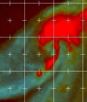
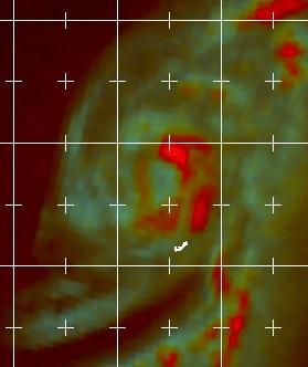
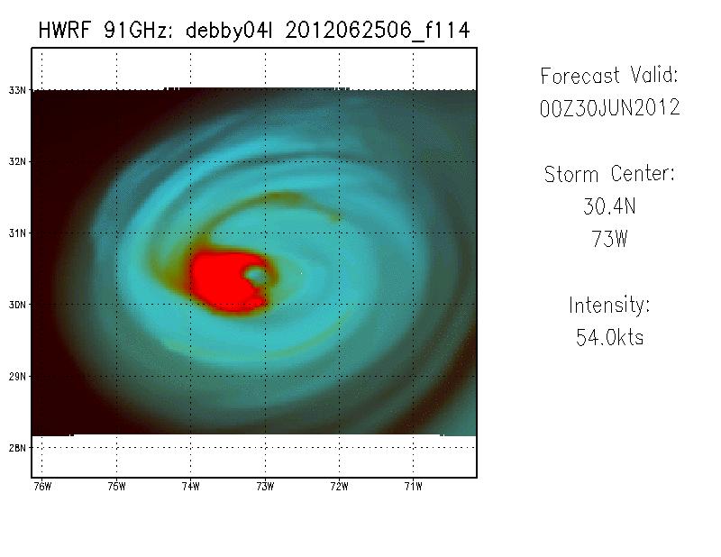
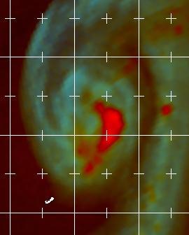
3 6.1.2 Provide real-time HWRF model-derived satellite imagery products for NHC forecasters. TRMM: 1515 UTC TRMM: 1515 UTC GOES-13: 1745 UTC Products were delivered beginning June 1. All products available in real time via NHC s intranet. EMC also producing some imagery, which is available on the EMC-HWRF website Downtime is currently experienced. whenever developmental CCS machine is down for maintenance or parallel testing.
4 6.1.3 Provide real-time high temporal resolution HWRF track/intensity/structure diagnostic products to NHC forecasters. Extend products to other regional models as data is made available. HWRF products were delivered beginning June 1. All products available in real time through NHC s intranet. Products also available on the HFIP website. AHW4 and UWN8 are also providing data; all products are currently available on the NHC intranet, and will be added soon to the HFIP website

5 6.1.4 Develop experimental vertical shear text diagnostic product for various layers within select operational global and regional models. Prototype for the GFS is currently running in real time, and is actively used by forecasters. Accompanying graphics have been developed. Multi-layer streamline analysis Hodograph Product also being developed for the ECMWF, and eventually the HWRF and GFDL.


6 6.1.5 Conduct a TC structure verification study comparing regional model simulated satellite/radar with satellite observations. (Ongoing, preliminary results in late August or early September.) Evaluating operational HWRF structure by verifying synthetic satellite microwave imagery against real satellite observations. Utilizes color composites to minimize the impacts of resolution, assumptions in the BT generation, and instrument differences. Verification done by quantifying the presence of an eyewall (in tenths) and/or a primary band (using a Dvorak log-10 spiral) in 24, 48, and 72 hour forecasts, against the closest available satellite pass.
7
8

9

10
11
12
13

14
15
16
17 NHC Plans Continue to develop and expand the shear diagnostic text product and accompanying graphical products Continue HWRF structure verification using synthetic satellite data and present results at the HFIP annual meeting
18 NHC Needs: HSU Wish List (Part 1) *** Green = Item is being addressed; Red = not addressed *** 1. Shear analysis for forecaster-specified layers (6.1.4) 2. User-selectable vertical cross sections of any field or combination of fields (Addressed internally) 3. Genesis probabilities derived from ensemble forecasts of global ensembles and possibly high resolution pre-tc models (Tim Marchok s HFIP product) 4. a) Magnitude and location of maximum 1-minute sustained 10m wind speed for each minute through integration for operations and diagnostics (6.1.3) b) Full wind field at hourly intervals; radius of 34, 50, 64 kt winds in each quadrant at hourly intervals (some groups produce surface data at hourly intervals, but 3D fields too computationally expensive) 5. Probability distribution of intensity change for ensembles, multi-model or single model, including RI ( or ?) 6. Guidance to NHC operations on the best locations for additional observations, eg supplemental soundings, G-IV dropsondes, C-130 data. (6.1.11) 7. Ensemble-based probabilistic guidance for track, intensity, wind structure, storm surge, rainfall, wind speed probabilities, and new products identified during the HFIP process. (6.1.9 ; Many of these currently, or soon to be available on HFIP website)
19 NHC Needs: HSU Wish List (Part 2) 8. Structural analyses using the mass and motion forecast fields to help diagnose tropical, subtropical, and extratropical stages (e.g. phase space). (Partially addressed by Bob Hart s Phase Space Diagrams for the GFS. HSU requests the expansion of this methodology to other models, and the development of additional products for diagnosing cyclone structure) 9. Capability to make model comparisons (contemporary and sequential runs of any combination of models) (Ability coming in AWIPS2) 10. Global model tropical cyclone formation index/indicator and verification methods. (JHT project to address this) 11. Simulated radar/microwave imagery (6.1.2 and 6.1.5) 12. Center locations at multiple vertical levels and depiction of vertical coherence (Addressed in part by vertical cross sections) 13. Ensemble mean track (6.1.1, 6.1.6, and HFIP website) 14. Surface mapping of accumulated forecast rainfall (already available for operational models internally)
OPERATIONAL CONSIDERATIONS FOR HURRICANE MODEL DIAGNOSTICS / VERIFICATION
 OPERATIONAL CONSIDERATIONS FOR HURRICANE MODEL DIAGNOSTICS / VERIFICATION Richard J. Pasch National Hurricane Center Hurricane Diagnostics and Verification Workshop Miami, Florida 4 May 2009 NOAA/NESDIS
NHC Ensemble/Probabilistic Guidance Products
 NHC Ensemble/Probabilistic Guidance Products Michael Brennan NOAA/NWS/NCEP/NHC Mark DeMaria NESDIS/STAR HFIP Ensemble Product Development Workshop 21 April 2010 Boulder, CO 1 Current Ensemble/Probability
HFIP Diagnostics Workshop Summary and Recommendations
 HFIP Diagnostics Workshop Summary and Recommendations Agenda Summary Operational input from NHC Atmospheric diagnostics EMC, NESDIS, CSU, GFDL, ESRL New verification techniques JNT/NCAR Land surface, ocean,
Hurricane Structure: Theory and Application. John Cangialosi National Hurricane Center
 Hurricane Structure: Theory and Application John Cangialosi National Hurricane Center World Meteorological Organization Workshop Is this Tropical, Subtropical, or Extratropical? Subtropical Tropical Extratropical
Forecast Challenges of the 2017 Hurricane Season and NHC Priorities for 2018
 Forecast Challenges of the 2017 Hurricane Season and NHC Priorities for 2018 Michael J. Brennan, Mark DeMaria, Eric S. Blake, Richard J. Pasch, Andrew Penny Annual HFIP Meeting 8 November 2017 Outline
SIXTH INTERNATIONAL WORKSHOP on TROPICAL CYCLONES. Working Group: Phillipe Caroff, Jeff Callaghan, James Franklin, Mark DeMaria
 WMO/CAS/WWW Topic 0.1: Track forecasts SIXTH INTERNATIONAL WORKSHOP on TROPICAL CYCLONES Rapporteur: E-mail: Lixion A. Avila NOAA/National Hurricane Center 11691 SW 17th Street Miami, FL 33165-2149, USA
GFDL Hurricane Model Ensemble Performance During the 2012 Hurricane Season
 GFDL Hurricane Model Ensemble Performance During the 2012 Hurricane Season Tim Marchok (NOAA / GFDL) Matt Morin (DRC HPTG / GFDL) Morris Bender (NOAA / GFDL) HFIP Team Telecon 12 December 2012 Acknowledgments:
Numerical Weather Prediction: Data assimilation. Steven Cavallo
 Numerical Weather Prediction: Data assimilation Steven Cavallo Data assimilation (DA) is the process estimating the true state of a system given observations of the system and a background estimate. Observations
2017 Year in review: JTWC TC Activity, Forecast Challenges, and Developmental Priorities
 2017 Year in review: JTWC TC Activity, Forecast Challenges, and Developmental Priorities Mean Annual TC Activity????????? Hurricane Forecast Improvement Program Annual Review 8-9 NOV 2017 Brian Strahl,
Ensemble Prediction Systems
 Ensemble Prediction Systems Eric Blake National Hurricane Center 7 March 2017 Acknowledgements to Michael Brennan 1 Question 1 What are some current advantages of using single-model ensembles? A. Estimates
Hurricane Structure: Theory and Diagnosis
 Hurricane Structure: Theory and Diagnosis 7 March, 2016 World Meteorological Organization Workshop Chris Landsea Chris.Landsea@noaa.gov National Hurricane Center, Miami Outline Structure of Hurricanes
ARW/EnKF performance for the 2009 Hurricane Season
 ARW/EnKF performance for the 2009 Hurricane Season Ryan D. Torn, Univ. at Albany, SUNY Chris Davis, Steven Cavallo, Chris Snyder, Wei Wang, James Done, NCAR/MMM 4 th EnKF Workshop 8 April 2010, Rensselaerville,
Ensemble TC Track/Genesis Products in
 Ensemble TC Track/Genesis Products in Parallel @NCO Resolution Members Daily Frequency Forecast Length NCEP ensemble (AEMN-para) GFS T574L64-33km(12/02/15) 20+1_CTL 00, 06, 12, 18 UTC 16 days (384hrs)
TC STRUCTURE GUIDANCE UPDATES
 TC STRUCTURE GUIDANCE UPDATES FROM NESDIS (CO)/CIRA Status and update for the multi-platform tropical cyclone wind analysis (MTCSWA) New microwave-sounder-based intensity and structure estimates New method
Structure & Intensity Change: Future Directions IWTC VI, Topic 1
 Structure & Intensity Change: Future Directions IWTC VI, Topic 1 Chair: Rob Rogers Rapporteurs Environmental Impacts (J. Evans) Inner Core Impacts (E. Ritchie) Oceanic Impacts (N. Shay) Observational Capabilities
Discussion on HFIP RDITT Experiments. Proposal for extending the life of RDITT for one more year: Future Plans from Individual Groups
 Discussion on HFIP RDITT Experiments Proposal for extending the life of RDITT for one more year: Future Plans from Individual Groups 1 EMC: Modifications to one-way hybrid ensemble-variational data assimilation
The Use of GPS Radio Occultation Data for Tropical Cyclone Prediction. Bill Kuo and Hui Liu UCAR
 The Use of GPS Radio Occultation Data for Tropical Cyclone Prediction Bill Kuo and Hui Liu UCAR Current capability of the National Hurricane Center Good track forecast improvements. Errors cut in half
Satellite Applications to Hurricane Intensity Forecasting
 Satellite Applications to Hurricane Intensity Forecasting Christopher J. Slocum - CSU Kate D. Musgrave, Louie D. Grasso, and Galina Chirokova - CIRA/CSU Mark DeMaria and John Knaff - NOAA/NESDIS Center
Expansion of NCEP Operational Hurricane Weather Research and Forecast (HWRF) Model Forecast Guidance to all Global Tropical Cyclones
 Model Forecast Guidance to all Global Tropical Cyclones") Expansion of NCEP Operational Hurricane Weather Research and Forecast (HWRF) Model Forecast Guidance to all Global Tropical Cyclones Dr. Vijay Tallapragada, Hurricane Team Leader & HFIP Development Manager,
Expansion of NCEP Operational Hurricane Weather Research and Forecast (HWRF) Model Forecast Guidance to all Global Tropical Cyclones Dr. Vijay Tallapragada, Hurricane Team Leader & HFIP Development Manager,
Advancements in Operations and Research on Hurricane Modeling and Ensemble Prediction System at EMC/NOAA
 Advancements in Operations and Research on Hurricane Modeling and Ensemble Prediction System at EMC/NOAA Zhan Zhang and Vijay Tallapragada EMC/NCEP/NOAA/DOC Acknowledgements: HWRF Team Members at EMC,
Using satellite-based remotely-sensed data to determine tropical cyclone size and structure characteristics
 DISTRIBUTION STATEMENT A. Approved for public release; distribution is unlimited. Using satellite-based remotely-sensed data to determine tropical cyclone size and structure characteristics PI: Elizabeth
NWS and Navy Plans for the ATCF and AWIPS2
 NWS and Navy Plans for the ATCF and AWIPS2 Mark DeMaria, Craig A. Mattocks, Christopher Mello, Michael Brennan and Monica Bozeman NOAA/NWS National Hurricane Center, Miami, FL Charles R. Sampson and Michael
Scientific Documentation for the Community release of the GFDL Vortex Tracker
 Scientific Documentation for the Community release of the GFDL Vortex Tracker May 2016 Version 3.7b The Developmental Testbed Center Timothy Marchok NOAA/GFDL Please send questions to: hwrf-help@ucar.edu
Applications Development and Diagnostics (ADD) Team Summary Part 2
 Team Summary Part 2") Applications Development and Diagnostics (ADD) Team Summary Part 2 Mark DeMaria, NOAA/NESDIS HFIP Annual Review Meeting Nov. 8-9, 2011, Miami, FL Input from: Chris Davis, James Doyle, Thomas Galarneau,
Applications Development and Diagnostics (ADD) Team Summary Part 2 Mark DeMaria, NOAA/NESDIS HFIP Annual Review Meeting Nov. 8-9, 2011, Miami, FL Input from: Chris Davis, James Doyle, Thomas Galarneau,
WELCOME TO THE 2018 RA-IV WORKSHOP ON HURRICANE FORECASTING AND WARNING
 WELCOME TO THE 2018 RA-IV WORKSHOP ON HURRICANE FORECASTING AND WARNING Richard J. Pasch and Daniel P. Brown Senior Hurricane Specialists National Hurricane Center ORIENTATION Use of PCs NHC Facility Workshop
A Multi-Model Ensemble for Western North Pacific Tropical Cyclone Intensity Prediction
 DISTRIBUTION STATEMENT A. Approved for public release; distribution is unlimited. A Multi-Model Ensemble for Western North Pacific Tropical Cyclone Intensity Prediction Jonathan R. Moskaitis Naval Research
COLORADO STATE UNIVERSITY FORECAST OF ATLANTIC HURRICANE ACTIVITY FROM OCTOBER 13 OCTOBER 26, 2017
 COLORADO STATE UNIVERSITY FORECAST OF ATLANTIC HURRICANE ACTIVITY FROM OCTOBER 13 OCTOBER 26, 2017 We expect that the next two weeks will be characterized by above-normal hurricane activity. (as of 13
Operational and Statistical Prediction of Rapid Intensity Change. Mark DeMaria and Eric Blake, NCEP/NHC John Kaplan, AOML/HRD
 Operational and Statistical Prediction of Rapid Intensity Change Mark DeMaria and Eric Blake, NCEP/NHC John Kaplan, AOML/HRD Outline Evaluation of NHC forecasts and deterministic models for rapid intensification
Objectives for meeting
 Objectives for meeting 1) Summarize planned experiments 2) Discuss resource availability Aircraft Instrumentation Expendables 3) Assign working groups to complete each experiment plan Flight planning and
HFIP Annual Review Meeting November 5-7, 2018 Embassy Suites by Hilton Miami International Airport 3974 NW S River Dr, Miami, FL 33142
 HFIP Annual Review Meeting November 5-7, 2018 Embassy Suites by Hilton Miami International Airport 3974 NW S River Dr, Miami, FL 33142 Overall Objectives The new HFIP Strategic Plan detailing the specific
The Evolution and Use of Objective Forecast Guidance at NHC
 The Evolution and Use of Objective Forecast Guidance at NHC James L. Franklin Branch Chief, Hurricane Specialist Unit National Hurricane Center 2010 EMC/MMM/DTC Workshop 1 Hierarchy of TC Track Models
DA/Initialization/Ensemble Development Team Milestones and Priorities
 DA/Initialization/Ensemble Development Team Milestones and Priorities Presented by Xuguang Wang HFIP annual review meeting Jan. 11-12, 2017, Miami, FL Fully cycled, self-consistent, dual-resolution, GSI
Hurricane Harvey the Name says it all. by Richard H. Grumm and Charles Ross National Weather Service office State College, PA
 Hurricane Harvey the Name says it all by Richard H. Grumm and Charles Ross National Weather Service office State College, PA 16803. 1. Overview Hurricane Harvey crossed the Texas coast (Fig. 1) as a category
Evaluating the Impact of Improved Track and Intensity Forecasts on Hurricane Watches and Warnings
 Evaluating the Impact of Improved Track and Intensity Forecasts on Hurricane Watches and Warnings Mark DeMaria, NOAA/NESDIS/StAR Andrea Schumacher, CIRA/CSU Dan Brown and Ed Rappaport, NHC Generally accepted
EMC multi-model ensemble TC track forecast
 EMC multi-model ensemble TC track forecast Jiayi Peng*, Yuejian Zhu and Richard Wobus* *IMSG at Environmental Modeling Center Environmental Modeling Center /NCEP/NOAA, Camp Springs, MD 2746 Acknowledgements:
Performance and Verification of HWRF/HMON Ensemble Prediction System in 2017 Real time Parallel Experiment. Zhan Zhang, Weiguo Wang
 1 Performance and Verification of HWRF/HMON Ensemble Prediction System in 2017 Real time Parallel Experiment Zhan Zhang, Weiguo Wang and the EMC Hurricane Team Environmental Modeling Center, NOAA/NWS/NCEP,
Hurricane Forecast Improvement Project (HFIP) Bob Gall HFIP Development Manager
 Bob Gall HFIP Development Manager") Hurricane Forecast Improvement Project (HFIP) Bob Gall HFIP Development Manager Boulder, Colorado June 26, 2012 2 The HFIP Project Vision/Goals Vision o Organize the hurricane community to dramatically
Hurricane Forecast Improvement Project (HFIP) Bob Gall HFIP Development Manager Boulder, Colorado June 26, 2012 2 The HFIP Project Vision/Goals Vision o Organize the hurricane community to dramatically
Motivation & Goal. We investigate a way to generate PDFs from a single deterministic run
 Motivation & Goal Numerical weather prediction is limited by errors in initial conditions, model imperfections, and nonlinearity. Ensembles of an NWP model provide forecast probability density functions
A Look Back at the 2012 Hurricane Season and a Look Ahead to 2013 & Beyond. Daniel Brown National Hurricane Center Miami, Florida 24 April 2013
 A Look Back at the 2012 Hurricane Season and a Look Ahead to 2013 & Beyond Daniel Brown National Hurricane Center Miami, Florida 24 April 2013 2012 Atlantic Verification Good News- Lots of Accuracy Records
Wind Speed Probability Products
 Wind Speed Probability Products Daniel Brown National Hurricane Center 2018 WMO Course 6 March 2018 Wind Speed Probabilities A Tool to Deal with Uncertainty Hurricane Irene Advisory Number 12 Issued 5:00
COLORADO STATE UNIVERSITY FORECAST OF ATLANTIC HURRICANE ACTIVITY FROM AUGUST 17 AUGUST 30, 2012
 COLORADO STATE UNIVERSITY FORECAST OF ATLANTIC HURRICANE ACTIVITY FROM AUGUST 17 AUGUST 30, 2012 We expect that the next two weeks will be characterized by above-average amounts (greater than 130 percent)
SH RI Events. Influence From Patterns Of Different Scale
 SH072014 RI Events Influence From Patterns Of Different Scale RI Explanation * Rapid intensification, approximately an increase of 2 Dvorak T-numbers or 30 knots in 24 hours, frequently occurs in JTWC
Ensemble Prediction Systems
 Ensemble Prediction Systems Eric S. Blake & Michael J. Brennan National Hurricane Center 8 March 2016 Acknowledgements to Rick Knabb and Jessica Schauer 1 Why Aren t Models Perfect? Atmospheric variables
NOAA s Hurricane Forecast Improvement Project: Framework for Addressing the Weather Research Forecasting Innovation Act of 2017
 NOAA s Hurricane Forecast Improvement Project: Framework for Addressing the Weather Research Forecasting Innovation Act of 2017 Frank Marks (NOAA/AOML/HRD) November 7, 2018 NOAA Hurricane Forecast Improvement
JTWC use of ensemble products. Matthew Kucas Joint Typhoon Warning Center Pearl Harbor, HI
 Matthew Kucas Joint Typhoon Warning Center Pearl Harbor, HI Overview Tropical cyclone track forecasting Deterministic model consensus and single-model ensembles as track forecasting aids Conveying uncertainty
NOAA Storm Surge Modeling Gaps and Priorities
 NOAA Storm Surge Modeling Gaps and Priorities HFIP Meeting November 9 th, 2017 Laura Paulik Alaka NHC Storm Surge Unit Introduction to Probabilistic Storm Surge P-Surge is based on an ensemble of Sea,
Overview of HFIP FY10 activities and results
 Overview of HFIP FY10 activities and results Bob Gall HFIP Annual Review Meeting Miami Nov 9, 2010 Outline In this presentation I will show a few preliminary results from the summer program. More detail
2012 AHW Stream 1.5 Retrospective Results
 2012 AHW Stream 1.5 Retrospective Results Ryan D. Torn, Univ. Albany, SUNY Chris Davis, Wei Wang, Jimy Dudhia, Tom Galarneau, Chris Snyder, James Done, NCAR/NESL/MMM Overview Since participation in HFIP
Evaluation and Improvement of HWRF PBL Physics using Aircraft Observations
 Evaluation and Improvement of HWRF PBL Physics using Aircraft Observations Jun Zhang NOAA/AOML/HRD with University of Miami/CIMAS HFIP Regional Modeling Team Workshop, 09/18/2012 Many thanks to my collaborators:
HWRF sensitivity to cumulus schemes
 HWRF sensitivity to cumulus schemes Mrinal K Biswas and Ligia R Bernardet HFIP Telecon, 01 February 2012 Motivation HFIP Regional Model Team Physics Workshop (Aug 11): Foci: Scientific issues on PBL and
NWS Operational Marine and Ocean Forecasting. Overview. Ming Ji. Ocean Prediction Center National Weather Service/NCEP. CIOSS/CoRP
 NWS Operational Marine and Ocean Forecasting Overview Ming Ji Ocean Prediction Center National Weather Service/NCEP CIOSS/CoRP CoRP Symposium Corvallis, OR Aug. 12-13, 13, 2008 Titanic Telegram Marine
TC rainfall forecasting
 1/21 TC rainfall forecasting Source: NASA, https://pmm.nasa.gov/trmm/hurricanes-and-typhoons Global TC Rainfall 2/21 Global TC Rainfall % of yearly total 3/21 35 000 0 30 000 0 25 000 0 20 000 0 15 000
Performance of the 2013 Operational HWRF
 Performance of the 2013 Operational HWRF Vijay Tallapragada & HWRF Team Environmental Modeling Center, NCEP/NOAA/NWS, NCWCP, College Park, MD 20740. HFIP Annual Review Meeting, February 19, 2014 1 Outline
COLORADO STATE UNIVERSITY FORECAST OF ATLANTIC HURRICANE ACTIVITY FROM AUGUST 14 AUGUST 27, 2014
 COLORADO STATE UNIVERSITY FORECAST OF ATLANTIC HURRICANE ACTIVITY FROM AUGUST 14 AUGUST 27, 2014 We expect that the next two weeks will be characterized by below-average amounts (less than 70 percent)
Developmental Testbed Center (DTC) Project for the Hurricane Forecast Improvement Program (HFIP)
 Project for the Hurricane Forecast Improvement Program (HFIP)") Developmental Testbed Center (DTC) Project for the Hurricane Forecast Improvement Program (HFIP) Final report documenting: Regional Application of the GSI- Hybrid Data Assimilation for Tropical Storm forecasts
Developmental Testbed Center (DTC) Project for the Hurricane Forecast Improvement Program (HFIP) Final report documenting: Regional Application of the GSI- Hybrid Data Assimilation for Tropical Storm forecasts
Tropical Storm List
 Tropical Storm Email List http://tstorms.org/ tropical-storms@tstorms.org Tropical-Storms is a mailing list only for those who are professionally active in either the research or forecasting of tropical
Wind Speed Probability Products. Daniel Brown and Michael Brennan National Hurricane Center
 Wind Speed Probability Products Daniel Brown and Michael Brennan National Hurricane Center 2017 WMO Course 7 March 2017 Wind Speed Probabilities A Tool to Deal with Uncertainty Hurricane Irene Advisory
Tropical Cyclone Modeling and Data Assimilation. Jason Sippel NOAA AOML/HRD 2018 WMO Workshop at NHC
 Tropical Cyclone Modeling and Data Assimilation Jason Sippel NOAA AOML/HRD 2018 WMO Workshop at NHC Outline History of TC forecast improvements in relation to model development Ongoing modeling/da developments
Use of the GFDL Vortex Tracker
 Use of the GFDL Vortex Tracker Tim Marchok NOAA / Geophysical Fluid Dynamics Laboratory WRF Tutorial for Hurricanes January 24, 2018 Outline History & description of the GFDL vortex tracker Inputs & Outputs
Na#onal Hurricane Center Official Intensity Errors
 Na#onal Hurricane Center Official Intensity Errors Assimilate Airborne Doppler Winds with WRF-EnKF Available for 20+ years but never used in operational models due to the lack of resolution and/or the
JMA Contribution to SWFDDP in RAV. (Submitted by Yuki Honda and Masayuki Kyouda, Japan Meteorological Agency) Summary and purpose of document
 Summary and purpose of document") WORLD METEOROLOGICAL ORGANIZATION COMMISSION FOR BASIC SYSTEMS OPAG on DPFS DPFS/RAV-SWFDDP-RSMT Doc. 7.1(1) (28.X.2010) SEVERE WEATHER FORECASTING AND DISASTER RISK REDUCTION DEMONSTRATION PROJECT (SWFDDP)
WORLD METEOROLOGICAL ORGANIZATION COMMISSION FOR BASIC SYSTEMS OPAG on DPFS DPFS/RAV-SWFDDP-RSMT Doc. 7.1(1) (28.X.2010) SEVERE WEATHER FORECASTING AND DISASTER RISK REDUCTION DEMONSTRATION PROJECT (SWFDDP)
OBJECTIVE CALIBRATED WIND SPEED AND CROSSWIND PROBABILISTIC FORECASTS FOR THE HONG KONG INTERNATIONAL AIRPORT
 P 333 OBJECTIVE CALIBRATED WIND SPEED AND CROSSWIND PROBABILISTIC FORECASTS FOR THE HONG KONG INTERNATIONAL AIRPORT P. Cheung, C. C. Lam* Hong Kong Observatory, Hong Kong, China 1. INTRODUCTION Wind is
Inner core dynamics: Eyewall Replacement and hot towers
 Inner core dynamics: Eyewall Replacement and hot towers FIU Undergraduate Hurricane Internship Lecture 4 8/13/2012 Why inner core dynamics is important? Current TC intensity and structure forecasts contain
HMON (HNMMB): Development of a new Hurricane model for NWS/NCEP operations
: Development of a new Hurricane model for NWS/NCEP operations") 1 HMON (HNMMB): Development of a new Hurricane model for NWS/NCEP operations Avichal Mehra, EMC Hurricane and Mesoscale Teams Environmental Modeling Center NOAA / NWS / NCEP HMON: A New Operational Hurricane
1 HMON (HNMMB): Development of a new Hurricane model for NWS/NCEP operations Avichal Mehra, EMC Hurricane and Mesoscale Teams Environmental Modeling Center NOAA / NWS / NCEP HMON: A New Operational Hurricane
- Introduction - Technical Presentation 49 th Session of the Typhoon Committee. Yokohama, Japan 21 February Munehiko Yamaguchi
 - Introduction - The Latest Model Simulation and Observational Studies related to Tropical Cyclone in Japan Technical Presentation 49 th Session of the Typhoon Committee Yokohama, Japan 21 February 2017
COAMPS-TC 2015 Version, Performance, and Future Plans
 COAMPS-TC 2015 Version, Performance, and Future Plans James D. Doyle, R. Hodur 1, J. Moskaitis, S. Chen, E. Hendricks 2, H. Jin, Y. Jin, A. Reinecke, S. Wang Naval Research Laboratory, Monterey, CA 1 IES/SAIC,
Subtropical and Hybrid Systems IWTC VII Topic 1.6
 Subtropical and Hybrid Systems IWTC VII Topic 1.6 John R. Gyakum Department of Atmospheric and Oceanic Sciences McGill University, Montreal Canada Working group: John L. Beven II, Lance F. Bosart, Fermin
The Properties of Convective Clouds Over the Western Pacific and Their Relationship to the Environment of Tropical Cyclones
 The Properties of Convective Clouds Over the Western Pacific and Their Relationship to the Environment of Tropical Cyclones Principal Investigator: Dr. Zhaoxia Pu Department of Meteorology, University
COLORADO STATE UNIVERSITY FORECAST OF ATLANTIC HURRICANE ACTIVITY FROM AUGUST 4-17, 2015
 COLORADO STATE UNIVERSITY FORECAST OF ATLANTIC HURRICANE ACTIVITY FROM AUGUST 4-17, 2015 We expect that the next two weeks will be characterized by below-average amounts (
COLORADO STATE UNIVERSITY FORECAST OF ATLANTIC HURRICANE ACTIVITY FROM AUGUST 18-31, 2017
 COLORADO STATE UNIVERSITY FORECAST OF ATLANTIC HURRICANE ACTIVITY FROM AUGUST 18-31, 2017 We expect that the next two weeks will be characterized by above-average amounts (>130%) of activity relative to
2014 real-time COAMPS-TC ensemble prediction
 2014 real-time COAMPS-TC ensemble prediction Jon Moskaitis, Alex Reinecke, Jim Doyle and the COAMPS-TC team Naval Research Laboratory, Monterey, CA HFIP annual review meeting, 20 November 2014 Real-time
The EMC Mission.. In response to operational requirements:
 The EMC Mission.. In response to operational requirements: Maintain operational model suite The scientific correctness and integrity of operational forecast modeling systems Modify current operational
COLORADO STATE UNIVERSITY FORECAST OF ATLANTIC HURRICANE ACTIVITY FROM SEPTEMBER 27-OCTOBER 10, 2018
 COLORADO STATE UNIVERSITY FORECAST OF ATLANTIC HURRICANE ACTIVITY FROM SEPTEMBER 27-OCTOBER 10, 2018 We expect that the next two weeks will be characterized by above-normal amounts of hurricane activity,
COLORADO STATE UNIVERSITY FORECAST OF ATLANTIC HURRICANE ACTIVITY FROM AUGUST 2 AUGUST 15, 2013
 COLORADO STATE UNIVERSITY FORECAST OF ATLANTIC HURRICANE ACTIVITY FROM AUGUST 2 AUGUST 15, 2013 We expect that the next two weeks will be characterized by below-average amounts (
Derrick Herndon and Chris Velden University of Wisconsin - Madison Cooperative Institute for Meteorological Satellite Studies
 CIMSS SATellite CONsensus (SATCON) Derrick Herndon and Chris Velden University of Wisconsin - Madison Cooperative Institute for Meteorological Satellite Studies Presented at International Workshop on Satellite
The revised Atlantic hurricane database (HURDAT2) - Chris Landsea, James Franklin, and Jack Beven May 2015
 - Chris Landsea, James Franklin, and Jack Beven May 2015") The revised Atlantic hurricane database (HURDAT2) - Chris Landsea, James Franklin, and Jack Beven May 2015 The National Hurricane Center (NHC) conducts a post-storm analysis of each tropical cyclone in
The revised Atlantic hurricane database (HURDAT2) - Chris Landsea, James Franklin, and Jack Beven May 2015 The National Hurricane Center (NHC) conducts a post-storm analysis of each tropical cyclone in
The Atlantic Hurricane Database Reanalysis Project
 The Atlantic Hurricane Database Reanalysis Project 9 November, 2015 14 th International Workshop on Wave Hindcasting and Forecasting Chris Landsea, National Hurricane Center, Miami, USA Chris.Landsea@noaa.gov
COLORADO STATE UNIVERSITY FORECAST OF ATLANTIC HURRICANE ACTIVITY FROM AUGUST 16 29, 2018
 COLORADO STATE UNIVERSITY FORECAST OF ATLANTIC HURRICANE ACTIVITY FROM AUGUST 16 29, 2018 We expect that the next two weeks will be characterized by below-normal amounts of hurricane activity. (as of 16
COLORADO STATE UNIVERSITY FORECAST OF ATLANTIC HURRICANE ACTIVITY FROM AUGUST 31 SEPTEMBER 13, 2012
 COLORADO STATE UNIVERSITY FORECAST OF ATLANTIC HURRICANE ACTIVITY FROM AUGUST 31 SEPTEMBER 13, 2012 We expect that the next two weeks will be characterized by average amounts (70-130 percent) of activity
Tropical Cyclone Forecast Assessment
 Tropical Cyclone Forecast Assessment Zachary Weller Colorado State University wellerz@stat.colostate.edu Joint work with Dr. Jennifer Hoeting (CSU) and Dr. Ligia Bernardet (NOAA) June 24, 2014 Zachary
COLORADO STATE UNIVERSITY FORECAST OF ATLANTIC HURRICANE ACTIVITY FROM SEPTEMBER 25 OCTOBER 8, 2014
 COLORADO STATE UNIVERSITY FORECAST OF ATLANTIC HURRICANE ACTIVITY FROM SEPTEMBER 25 OCTOBER 8, 2014 We expect that the next two weeks will be characterized by below-average amounts (
The National Weather Service of the Future: Building a Weather-Ready Nation
 The of the Future: Building a Weather-Ready Nation Dr. Louis W. Uccellini Director, NOAA Assistant Administrator for Weather Services NCEP Production Suite Review December 2, 2014 Outline Building a Weather-Ready
The Impacts of GPS Radio Occultation Data on the Analysis and Prediction of Tropical Cyclones. Bill Kuo, Xingqin Fang, and Hui Liu UCAR COSMIC
 The Impacts of GPS Radio Occultation Data on the Analysis and Prediction of Tropical Cyclones Bill Kuo, Xingqin Fang, and Hui Liu UCAR COSMIC GPS Radio Occultation α GPS RO observations advantages for
Advanced diagnostics of tropical cyclone inner-core structure using aircraft observations
 Advanced diagnostics of tropical cyclone inner-core structure using aircraft observations Jun Zhang, David Nolan, Robert Rogers, Paul Reasor and Sylvie Lorsolo HFIP Proposal Review, 5/15/2013 Acknowledgements
Some Thoughts on HFIP. Bob Gall
 Some Thoughts on HFIP Bob Gall Thanks! For putting up with me for the last six years, For helping to create a Hurricane Project that I believe has been very successful I will be mostly retiring at the
COLORADO STATE UNIVERSITY FORECAST OF ATLANTIC HURRICANE ACTIVITY FROM AUGUST 30 SEPTEMBER 12, 2013
 COLORADO STATE UNIVERSITY FORECAST OF ATLANTIC HURRICANE ACTIVITY FROM AUGUST 30 SEPTEMBER 12, 2013 We expect that the next two weeks will be characterized by average amounts (70-130 percent) of activity
A Preliminary Exploration of the Upper Bound of Tropical Cyclone Intensification
 A Preliminary Exploration of the Upper Bound of Tropical Cyclone Intensification Jonathan L. Vigh (NCAR/RAL) Kerry Emanuel (MIT) Mrinal K. Biswas (NCAR/RAL) Eric A. Hendricks (Naval Postgraduate School)
Augmentation of Early Intensity Forecasting in Tropical Cyclones
 DISTRIBUTION STATEMENT A. Approved for public release; distribution is unlimited. Augmentation of Early Intensity Forecasting in Tropical Cyclones J. Scott Tyo College of Optical Sciences University of
COLORADO STATE UNIVERSITY FORECAST OF ATLANTIC HURRICANE ACTIVITY FROM SEPTEMBER 13-SEPTEMBER 26, 2018
 COLORADO STATE UNIVERSITY FORECAST OF ATLANTIC HURRICANE ACTIVITY FROM SEPTEMBER 13-SEPTEMBER 26, 2018 We expect that the next two weeks will be characterized by near-normal amounts of hurricane activity.
Transitioning Physics Advancements into the Operational Hurricane WRF Model
 Transitioning Physics Advancements into the Operational Hurricane WRF Model KATHRYN NEWMAN, MRINAL BISWAS, LAURIE CARSON N OA A / ESR L T EA M M E M B E RS: E. K ALINA, J. F RIMEL, E. GRELL, AND L. B ERNARDET
Storm Summary for Hurricane Joaquin
 Storm Summary for Hurricane Joaquin Wednesday, September 30, 2015 at 5 PM EDT (Output from Hurrevac, based on National Hurricane Center Forecast Advisory #12) Joaquin is currently a Category 1 hurricane
Heavy rains and precipitable water anomalies August 2010 By Richard H. Grumm And Jason Krekeler National Weather Service State College, PA 16803
 Heavy rains and precipitable water anomalies 17-19 August 2010 By Richard H. Grumm And Jason Krekeler National Weather Service State College, PA 16803 1. INTRODUCTION Heavy rain fell over the Gulf States,
A Simplified Dynamical System for Tropical Cyclone Intensity Prediction
 68 M O N T H L Y W E A T H E R R E V I E W VOLUME 137 A Simplified Dynamical System for Tropical Cyclone Intensity Prediction MARK DEMARIA NOAA/NESDIS, Fort Collins, Colorado (Manuscript received 27 December
Observing system experiments of MTSAT-2 Rapid Scan Atmospheric Motion Vector for T-PARC 2008 using the JMA operational NWP system
 Tenth International Winds Workshop 1 Observing system experiments of MTSAT-2 Rapid Scan Atmospheric Motion Vector for T-PARC 2008 using the JMA operational NWP system Koji Yamashita Japan Meteorological
Applications Development and Diagnostics Team FY10 Progress Report
 Applications Development and Diagnostics Team FY10 Progress Report Mark DeMaria NOAA/NESDIS/STAR Wallace Hogsett NOAA/NCEP/NHC HFIP Annual Review Meeting November 9-10, 2010 Miami, FL 1 ADD Team Members
Overview of the Tropical Cyclone Guidance Project
 Overview of the Tropical Cyclone Guidance Project Dr. Jonathan L. Vigh With thanks to Mahsa Mirzargar (Univ. of Miami) Shanghai Typhoon Institute 09 July 2018 NCAR is sponsored by the National Science
Tropical Cyclones. Objectives
 Tropical Cyclones FIU Undergraduate Hurricane Internship Lecture 2 8/8/2012 Objectives From this lecture you should understand: Global tracks of TCs and the seasons when they are most common General circulation
NOAA/NESDIS Tropical Web Page with LEO Satellite Products and Applications for Forecasters
 NOAA/NESDIS Tropical Web Page with LEO Satellite Products and Applications for Forecasters Sheldon Kusselson National Oceanic and Atmospheric Administration (NOAA) National Environmental Satellite Data
The Local Wind Forecast and Its Uncertainty (Completing the Wind Forecast)
") The Local Wind Forecast and Its Uncertainty (Completing the Wind Forecast) Florida Governor Hurricane Conference May 11-16 2014 Pablo Santos Meteorologist In Charge NWS Miami/South Florida Forecast Office
The Local Wind Forecast and Its Uncertainty (Completing the Wind Forecast) Florida Governor Hurricane Conference May 11-16 2014 Pablo Santos Meteorologist In Charge NWS Miami/South Florida Forecast Office
Tri-Agency Forecast Discussion for August 24, 2010
 Created 1600 UTC August 24, 2010 Tri-Agency Forecast Discussion for August 24, 2010 GRIP Forecast Team: Cerese Inglish, Matt Janiga, Andrew Martin, Dan Halperin, Jon Zawislak, Ellen Ramirez, Amber Reynolds,