Impact of the Loss of QuikSCAT on NOAA NWS Marine Warning and
|
|
|
- Griselda Greene
- 6 years ago
- Views:
Transcription
1 Impact of the Loss of QuikSCAT on NOAA NWS Marine Warning and Forecast Operations Joseph Sienkiewicz 1 Michael J. Brennan 2, Richard Knabb 3, Paul S. Chang 4, Hugh Cobb 2, Zorana J. Jelenak 5, Khalil A. Ahmad 4, Seubson Soisuvarn 4, Affiliations 1 NOAA Ocean Prediction Center David Kosier 1, 2 Tropical lprediction i Center George Bancroft 1 3 The Weather Channel 4 NESDIS StAR OVWST, Barcelona Spain 5 UCAR 1


 QuikSCAT May 19,")
2 High resolution Ocean Surface Vector Winds (OSVW) fully integrated into operations Twice daily near complete wind field Increased situational awareness Improved ddetection and warning capability Enhanced understanding of winds over oceans Allowed focus on extreme cyclones (Hurricane Force) QuikSCAT May 19, 2010 OVWST, Barcelona Spain 2
3 Without QuikSCAT Forecasters now soley rely on: Satellite Interpretation Skills NWP Analyses and short-term forecasts ASCAT Ship and buoy observations Situational awareness is reduced Consistency and confidence reduced May 19, 2010 OVWST, Barcelona Spain 3


4 Impact of QuikSCAT Loss Tropical Analysis and Forecast Branch 10 year climatology of Gulf of Tehuantepec gap wind events based on QuikSCAT showed an average of 6 to 8 storm force events per cold season TAFB issued a total of 15 Gale and 5 Storm warnings for the area during the cold season based on improving NWP model output, but could not get confirmation of the Storm warnings from ASCAT Brennan et al. (2010) Wea. Forecasting Typically 1 ASCAT pass per day hits this region, compared to 2 QuikSCAT passes on most days From Jan Mar 2010, TAFB issued 20 Gale warnings in their Atlantic waters, 9 in the Gulf of Mexico, and 4 in the Caribbean May 19, 2010 OVWST, Barcelona Spain 4
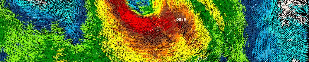
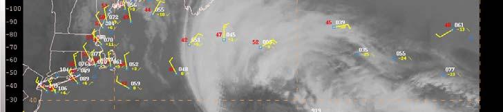
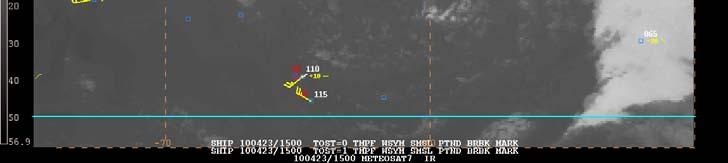
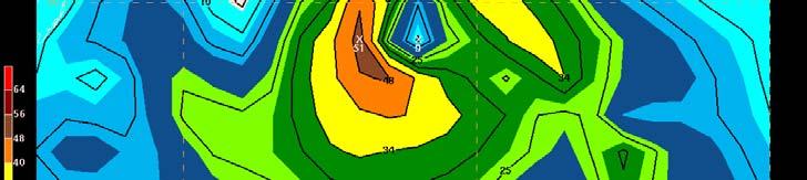
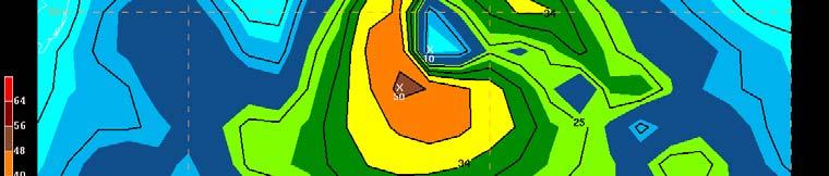
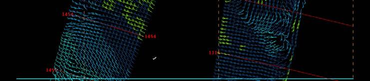
5 Case Example 8 14 January 2010 Gulf of Mexico Gale/Tehuantepec Storm Surface analysis, ship/buoy obs and ASCAT every 6 h from 8 14 January May 19, 2010 OVWST, Barcelona Spain 5
6 Case Example 8 14 January 2010 Gulf Gale/Tehuantepec Storm Only 5 ASCAT hits on the Gulf of Tehuantepec in a 7 day period Strongest ASCAT winds kt on 10 Jan No ASCAT data in region from 03 UTC 9 Jan through 15 UTC 10 Jan and from 15 UTC 10 Jan to 04 UTC 12 Jan 3 storm force ship observations Only a couple ASCAT gale force retrievals in far SW Gulf of Mexico Summary of lost capability bl due to loss of QuikSCAT Ability to capture storm force winds Full outline of area impacted by gale force winds in strongest events Ability to compare the model wind field with observations over a large spatial area Decreased forecaster confidence for severity, coverage, and timing of most extreme events May 19, 2010 OVWST, Barcelona Spain 6


7 Specific events Dec 9, 2009 Hawaii big wave event Tropical Storm Nida other than satellite data and without QuikSCAT data the ability to measure winds for these islands has been severely hampered making it difficult to verify any tropical system. Jan, 2020 C/V Horizon Hunter damaged en route to Guam diverted to Hawaii May 19, 2010 OVWST, Barcelona Spain 7

8 Hurricane Force Observations (Oct 07 ~ May 08 ) QS km QS - 25 km AS - opr AS - new GFS OBS


9 QuikSCAT vs. NCEP Global Forecast System OVWST, Barcelona Spain May 19,

10 April 23, 2010 Forecaster tools the Quandary Satellite imagery interpretation etat Result 986 STORM Surface observations Reality do not know intensity ASCAT NWP Analyses/forecasts May 19, 2010 OVWST, Barcelona Spain 10
11 % Wind Error QSCAT 25 km NRT vs. GDAS Aug 08 Jun 09 GALE STORM HURRICANE FORCE May 19, 2010 OVWST, Barcelona Spain 11
12 Hurricane Force Extra tropical Cyclones Detection and Warning Trend using QuikSCAT WARNING CATEGORIES Pre- QSCAT50 1. GALE kt 2. STORM >48 C y 40 c kt l o n e 30 s QSCAT ERA 1. GALE kt 2. STORM kt 3. HURCN FORCE > 64 kt Hurricane Force Warning Initiated Dec 2000 Detection increased with: -Forecaster familiarity -Data availability -Improved p resolution o -Improved algorithm Hurricane Force Wind Warning Initiated Dec km QuikSCAT Available in N AWIPS Oct km QuikSCAT available May Improved wind algorithm and rain flag Oct Atlantic Pacific Totals A 289 QuikSCAT Launch 14 Jun P May 19, 2010 OVWST, Barcelona Spain 12


 DJFMA (32.")
 DJFMA (29.")

13 Forecaster estimated Hurricane Force cyclones Sep 09 Apr With 5 QSCAT 0 Atlantic Atl below previous 5 40 yr average (43) DJFMA (32.6) 22 Pacific Pac at avg. (40.2) DJFMA (29.8) 28 Atlantic *highly subjective post QuikSCAT Pacific May 19, 2010 OVWST, Barcelona Spain 13
14 10 Forecaster estimated Hurricane Force cyclones Monthly Distribution vs average 9 8 QuikSCAT Failure Nov Atlantic Average 4 Atlantic Pacific 6% reduction vs. 5 yr avg QuikSCAT Failure Nov 09 0 Sept Oct Nov Dec Jan Feb Mar Apr Pacific Average Atlantic 33% reduction vs. 5 yr avg. 4 Pacific May 19, 2010 OVWST, Barcelona SeptSpain Oct Nov Dec Jan Feb Mar Apr 14
15 Forecaster verification 48,96 Pacific, Atlantic Probability of Detection (POD) 0.4 POD 48_PAC_HF POD 48_PAC_Storm POD 48_PAC_Gale Pac 48 Atl ONDJFM * (DJFM) Only POD 48_ATL_HF POD 48_ATL_Storm POD 48_ATL_Gale POD 96_PAC_HF POD 96_ATL_HF 0.3 POD 96_PAC_Storm 0.3 POD 96_ATL_Storm 0.2 POD 96_PAC_Gale 0.2 POD 96_ATL_Gale Pac Atl 96 May 19, 2010 OVWST, Barcelona Spain 15
16 Forecaster verification 48,96 Pacific, Atlantic False Alarm Rate(FAR) _PAC_HF _PAC_Storm 48_PAC_Gale Pac 48 Atl _ATL_HF ONDJFM * (DJFMA) Only 48_ATL_Storm 48_ATL_Gale _PAC_HF _PAC_Storm _ATL_HF _ATL_Storm 96_PAC_Gale _ATL_Gale Pac Atl 96 0 May 19, 2010 OVWST, Barcelona Spain 16
17 Summary Have lost OVW consistency for dfii defining warnings relying heavily on imagery, NWP and ASCAT less observed HF cyclones (Atlantic) nearly all not verified by observations cyclone verification suggests forecasters growing greliance on NWP to estimate warning categories (HF cyclones) Need to compare NWP analyses to forecaster estimated warnings NWP (GDAS) low bias for warning categories (compared to QSCAT) less storm force in Gulf of Tehuantepec less able to define warning areas need to examine other orographic jets (Greenland Tip Jet) W Pacific cyclones reduced detection capability Atlantic hurricanes impact still to be determined May 19, 2010 OVWST, Barcelona Spain 17
18 Impact of QuikSCAT Loss Tropical Cyclones NHC has not had any TCs develop in its AOR since the failure of QuikSCAT Likely impacts going forward into 2010 season: Loss of useful data for the analyzing the location, intensity, and structure of TCs, particularly those that are not sampled by aircraft reconnaissance Even ASCAT hits often fail to sample the entire TC circulation Reduced capability to identify winds above tropical storm force due to resolution and retrieval algorithm issues Degraded analysis of 34 kt wind radii in major hurricanes not sampled by aircraft reconnaissance Fewer passes over formative systems QuikSCAT was occasionally helpful in making the decision to initiate advisories May 19, 2010 OVWST, Barcelona Spain 18


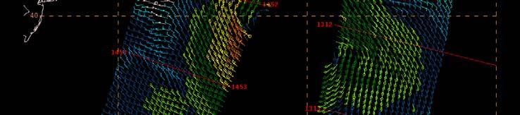
19 Great Circle Ray Tracing North coast New Guinea Dec GFS Dec f045 QS Dec KTS GFS Dec f033 GFS Dec f021 May 19, 2010 OVWST, Barcelona Spain 19
Zorana Jelenak Paul S. Chang Khalil Ahmed (OPC) Seubson Soisuvarn Qi Zhu NOAA/NESDIS/STAR-UCAR
 Seubson Soisuvarn Qi Zhu NOAA/NESDIS/STAR-UCAR") Near Real Time ASCAT Wind Vectors at NOAA and High Wind Issue Zorana Jelenak Paul S. Chang Khalil Ahmed (OPC) Seubson Soisuvarn Qi Zhu NOAA/NESDIS/STAR-UCAR ASCAT Wind Processing Implemented at NOAA Feb
Near Real Time ASCAT Wind Vectors at NOAA and High Wind Issue Zorana Jelenak Paul S. Chang Khalil Ahmed (OPC) Seubson Soisuvarn Qi Zhu NOAA/NESDIS/STAR-UCAR ASCAT Wind Processing Implemented at NOAA Feb
An Update Usage of ASCAT and OSCAT Winds at the NOAA Ocean Prediction Center (OPC), National Hurricane Center (NHC)
, National Hurricane Center (NHC)") An Update Usage of ASCAT and OSCAT Winds at the NOAA Ocean Prediction Center (OPC), National Hurricane Center (NHC) Joseph Sienkiewicz (OPC), Michael Brennan (NHC), Gregory McFadden (IMSG), Hugh D. Cobb
An Update Usage of ASCAT and OSCAT Winds at the NOAA Ocean Prediction Center (OPC), National Hurricane Center (NHC) Joseph Sienkiewicz (OPC), Michael Brennan (NHC), Gregory McFadden (IMSG), Hugh D. Cobb
J16.1 PRELIMINARY ASSESSMENT OF ASCAT OCEAN SURFACE VECTOR WIND (OSVW) RETRIEVALS AT NOAA OCEAN PREDICTION CENTER
 RETRIEVALS AT NOAA OCEAN PREDICTION CENTER") J16.1 PRELIMINARY ASSESSMENT OF ASCAT OCEAN SURFACE VECTOR WIND (OSVW) RETRIEVALS AT NOAA OCEAN PREDICTION CENTER Khalil. A. Ahmad* PSGS/NOAA/NESDIS/StAR, Camp Springs, MD Joseph Sienkiewicz NOAA/NWS/NCEP/OPC,
J16.1 PRELIMINARY ASSESSMENT OF ASCAT OCEAN SURFACE VECTOR WIND (OSVW) RETRIEVALS AT NOAA OCEAN PREDICTION CENTER Khalil. A. Ahmad* PSGS/NOAA/NESDIS/StAR, Camp Springs, MD Joseph Sienkiewicz NOAA/NWS/NCEP/OPC,
NHC Ocean Vector Winds Update
 NHC Ocean Vector Winds Update Michael J. Brennan NOAA/NWS/NCEP National Hurricane Center International Ocean Vector Winds Science Team Meeting Portland, Oregon, 20 May 2015 Current Status NHC is currently
NWS Operational Marine and Ocean Forecasting. Overview. Ming Ji. Ocean Prediction Center National Weather Service/NCEP. CIOSS/CoRP
 NWS Operational Marine and Ocean Forecasting Overview Ming Ji Ocean Prediction Center National Weather Service/NCEP CIOSS/CoRP CoRP Symposium Corvallis, OR Aug. 12-13, 13, 2008 Titanic Telegram Marine
QuikSCAT Analysis of Hurricane Force Extratropical Cyclones in the Pacific Ocean
 University of Rhode Island DigitalCommons@URI Senior Honors Projects Honors Program at the University of Rhode Island 2010 QuikSCAT Analysis of Hurricane Force Extratropical Cyclones in the Pacific Ocean
The Operational Use of QuikSCAT Ocean Surface Vector Winds at the National Hurricane Center
 VOLUME 24 W E A T H E R A N D F O R E C A S T I N G JUNE 2009 The Operational Use of QuikSCAT Ocean Surface Vector Winds at the National Hurricane Center MICHAEL J. BRENNAN NOAA/NWS/NCEP/National Hurricane
SMAP Winds. Hurricane Irma Sep 5, AMS 33rd Conference on Hurricanes and Tropical Meteorology Ponte Vedra, Florida, 4/16 4/20, 2018
 Intensity and Size of Strong Tropical Cyclones in 2017 from NASA's SMAP L-Band Radiometer Thomas Meissner, Lucrezia Ricciardulli, Frank Wentz, Remote Sensing Systems, Santa Rosa, USA Charles Sampson, Naval
Joan M. Von Ahn, Joseph M. Sienkiewicz and Gregory M. McFadden NOAA Ocean Prediction Center 5200 Auth Road Camp Springs, MD USA
 The Application of Sea Level Pressure and Vorticity Fields derived from the University of Washington Planetary Boundary Layer Model in the NOAA Ocean Prediction Center Joan M. Von Ahn, Joseph M. Sienkiewicz
Outline of 4 Lectures
 Outline of 4 Lectures 1. Sept. 17, 2008: TC best track definition and datasets, global distribution of TCs; Review of history of meteorological satellites, introducing different orbits, scanning patterns,
Integrating Multiple Scatterometer Observations into a Climate Data Record of Ocean Vector Winds
 Integrating Multiple Scatterometer Observations into a Climate Data Record of Ocean Vector Winds Lucrezia Ricciardulli and Frank Wentz Remote Sensing Systems, CA, USA E-mail: Ricciardulli@remss.com presented
APPLICATIONS OF SEA-LEVEL PRESSURE
 APPLICATIONS OF SEA-LEVEL PRESSURE RETRIEVAL FROM SCATTEROMETER WINDS Jérôme Patoux, Ralph C. Foster and Robert A. Brown OVWST meeting Seattle, November 20, 2008 Pressure retrieval: how does it work? model
Hurricane Structure: Theory and Diagnosis
 Hurricane Structure: Theory and Diagnosis 7 March, 2016 World Meteorological Organization Workshop Chris Landsea Chris.Landsea@noaa.gov National Hurricane Center, Miami Outline Structure of Hurricanes
NHC Ensemble/Probabilistic Guidance Products
 NHC Ensemble/Probabilistic Guidance Products Michael Brennan NOAA/NWS/NCEP/NHC Mark DeMaria NESDIS/STAR HFIP Ensemble Product Development Workshop 21 April 2010 Boulder, CO 1 Current Ensemble/Probability
GAMINGRE 8/1/ of 7
 FYE 09/30/92 JULY 92 0.00 254,550.00 0.00 0 0 0 0 0 0 0 0 0 254,550.00 0.00 0.00 0.00 0.00 254,550.00 AUG 10,616,710.31 5,299.95 845,656.83 84,565.68 61,084.86 23,480.82 339,734.73 135,893.89 67,946.95
August Forecast Update for Atlantic Hurricane Activity in 2012
 August Forecast Update for Atlantic Hurricane Activity in 2012 Issued: 6 th August 2012 by Professor Mark Saunders and Dr Adam Lea Dept. of Space and Climate Physics, UCL (University College London), UK
The ECMWF Extended range forecasts
 The ECMWF Extended range forecasts Laura.Ferranti@ecmwf.int ECMWF, Reading, U.K. Slide 1 TC January 2014 Slide 1 The operational forecasting system l High resolution forecast: twice per day 16 km 91-level,
16 th RAV/TCC Meeting, Solomon Is Misaeli Funaki- RSMC Nadi
 16 th RAV/TCC Meeting, Solomon Is. 2016 Misaeli Funaki- RSMC Nadi 2014/15 seasonal activities reviewed -Climate Indices - MJO..etc - Seasonal Review 2015/16 seasonal activities reviewed -Climate Indices
AnuMS 2018 Atlantic Hurricane Season Forecast
 AnuMS 2018 Atlantic Hurricane Season Forecast Issued: April 10, 2018 by Dale C. S. Destin (follow @anumetservice) Director (Ag), Antigua and Barbuda Meteorological Service (ABMS) The *AnuMS (Antigua Met
P2.4 THE IMPACT OF TROPICAL CYCLONE REMNANTS ON THE RAINFALL OF THE NORTH AMERICAN SOUTHWEST REGION
 P2.4 THE IMPACT OF TROPICAL CYCLONE REMNANTS ON THE RAINFALL OF THE NORTH AMERICAN SOUTHWEST REGION by Elizabeth A. Ritchie 1 and David Szenasi University of New Mexico 1. INTRODUCTION New Mexico has a
The 2009 Hurricane Season Overview
 The 2009 Hurricane Season Overview Jae-Kyung Schemm Gerry Bell Climate Prediction Center NOAA/ NWS/ NCEP 1 Overview outline 1. Current status for the Atlantic, Eastern Pacific and Western Pacific basins
National Hurricane Center Forecast Accuracy: Past and Present James L. Franklin Branch Chief, Hurricane Specialist Unit National Hurricane Center
 National Hurricane Center Forecast Accuracy: Past and Present James L. Franklin Branch Chief, Hurricane Specialist Unit National Hurricane Center 30 January 2012 1 NHC Forecast Verification NHC verifies
Impact of METOP ASCAT Ocean Surface Winds in the NCEP GDAS/GFS and NRL NAVDAS
 Impact of METOP ASCAT Ocean Surface Winds in the NCEP GDAS/GFS and NRL NAVDAS COAMPS @ Li Bi 1,2 James Jung 3,4 Michael Morgan 5 John F. Le Marshall 6 Nancy Baker 2 Dave Santek 3 1 University Corporation
STATUS ON THE USE OF SCATTEROMETER DATA AT METEO FRANCE
 STATUS ON THE USE OF SCATTEROMETER DATA AT METEO FRANCE Christophe Payan Centre National de Recherches Météorologiques, M CNRS-GAME CNRS and Météo-France Toulouse, France 9th International Winds Workshop,
Forecast Challenges of the 2017 Hurricane Season and NHC Priorities for 2018
 Forecast Challenges of the 2017 Hurricane Season and NHC Priorities for 2018 Michael J. Brennan, Mark DeMaria, Eric S. Blake, Richard J. Pasch, Andrew Penny Annual HFIP Meeting 8 November 2017 Outline
Hurricane Structure: Theory and Application. John Cangialosi National Hurricane Center
 Hurricane Structure: Theory and Application John Cangialosi National Hurricane Center World Meteorological Organization Workshop Is this Tropical, Subtropical, or Extratropical? Subtropical Tropical Extratropical
NOAA Operational Ocean Surface. Vector Winds Requirements Workshop. National Hurricane Center Miami, FL June 5 7, 2006
 NOAA Operational Ocean Surface Vector Winds Requirements Workshop National Hurricane Center Miami, FL June 5 7, 2006 NOAA Operational Satellite Ocean Surface Vector Winds Requirements Workshop Report Convened
Current and Future Experiments to Improve Assimilation of Surface Winds from Satellites in Global Models
 Current and Future Experiments to Improve Assimilation of Surface Winds from Satellites in Global Models Sharan Majumdar, RSMAS/UMiami Bob Atlas, NOAA/AOML Current and Future Collaborators: Ryan Torn (SUNY
Operational Use of Scatterometer Winds in the JMA Data Assimilation System
 Operational Use of Scatterometer Winds in the Data Assimilation System Masaya Takahashi Numerical Prediction Division, Japan Meteorological Agency () International Ocean Vector Winds Science Team Meeting,
The Atlantic Hurricane Database Reanalysis Project
 The Atlantic Hurricane Database Reanalysis Project 9 November, 2015 14 th International Workshop on Wave Hindcasting and Forecasting Chris Landsea, National Hurricane Center, Miami, USA Chris.Landsea@noaa.gov
HURRICANES AND TROPICAL STORMS OF THE WEST COAST OF MEXlC
 302 MONTHLY WEATHER REVIEW Vol. 99, No. 4 HURRICANES AND TROPICAL STORMS OF THE WEST COAST OF MEXlC SERGIO SERRA C. * Institute of Geophysics, National Autonomous University of Mexico, D. F. Mexico UDC
AnuMS 2018 Atlantic Hurricane Season Forecast
 AnuMS 2018 Atlantic Hurricane Season Forecast Issued: May 10, 2018 by Dale C. S. Destin (follow @anumetservice) Director (Ag), Antigua and Barbuda Meteorological Service (ABMS) The *AnuMS (Antigua Met
JTWC's Use of TRMM in Typhoon Forecast Operations
 Use of TRMM in Typhoon Forecast Operations JTWC's Use of TRMM in Typhoon Forecast Operations Slide 1/24 Use of TRMM in Typhoon Forecast Operations Slide 2/24 Opening Comments The current microwave satellite
Operational Use of Scatterometer Winds at JMA
 Operational Use of Scatterometer Winds at JMA Masaya Takahashi Numerical Prediction Division, Japan Meteorological Agency (JMA) 10 th International Winds Workshop, Tokyo, 26 February 2010 JMA Outline JMA
ECMWF: Weather and Climate Dynamical Forecasts
 ECMWF: Weather and Climate Dynamical Forecasts Medium-Range (0-day) Partial coupling Extended + Monthly Fully coupled Seasonal Forecasts Fully coupled Atmospheric model Atmospheric model Wave model Wave
11/17/2017. Memorable Hurricanes of 2004 MET 4532
 MET 4532 2004 Hurricane Season Lecture 31 & 32 2004, 2005, and After 17-20 November 2017 1 2 Memorable Hurricanes of 2004 Hurricane Dates Damage (US) Deaths (US) Charlie (4) 9-14 AUG $14B 10 Ivan (4) 2-24
August Forecast Update for Atlantic Hurricane Activity in 2015
 August Forecast Update for Atlantic Hurricane Activity in 2015 Issued: 5 th August 2015 by Professor Mark Saunders and Dr Adam Lea Dept. of Space and Climate Physics, UCL (University College London), UK
John Steffen and Mark A. Bourassa
 John Steffen and Mark A. Bourassa Funding by NASA Climate Data Records and NASA Ocean Vector Winds Science Team Florida State University Changes in surface winds due to SST gradients are poorly modeled
ASCAT NRT Data Processing and Distribution at NOAA/NESDIS
 ASCAT NRT Data Processing and Distribution at NOAA/NESDIS Paul S. Chang, Zorana Jelenak, Seubson Soisuvarn, Qi Zhu Gene Legg and Jeff Augenbaum National Oceanic and Atmospheric Administration (NOAA) National
August Forecast Update for Atlantic Hurricane Activity in 2016
 August Forecast Update for Atlantic Hurricane Activity in 2016 Issued: 5 th August 2016 by Professor Mark Saunders and Dr Adam Lea Dept. of Space and Climate Physics, UCL (University College London), UK
A Preliminary Exploration of the Upper Bound of Tropical Cyclone Intensification
 A Preliminary Exploration of the Upper Bound of Tropical Cyclone Intensification Jonathan L. Vigh (NCAR/RAL) Kerry Emanuel (MIT) Mrinal K. Biswas (NCAR/RAL) Eric A. Hendricks (Naval Postgraduate School)
PRMS WHITE PAPER 2014 NORTH ATLANTIC HURRICANE SEASON OUTLOOK. June RMS Event Response
 PRMS WHITE PAPER 2014 NORTH ATLANTIC HURRICANE SEASON OUTLOOK June 2014 - RMS Event Response 2014 SEASON OUTLOOK The 2013 North Atlantic hurricane season saw the fewest hurricanes in the Atlantic Basin
Ensemble Prediction Systems
 Ensemble Prediction Systems Eric Blake National Hurricane Center 7 March 2017 Acknowledgements to Michael Brennan 1 Question 1 What are some current advantages of using single-model ensembles? A. Estimates
Study for utilizing high wind speed data in the JMA s Global NWP system
 Study for utilizing high wind speed data in the JMA s Global NWP system Masami Moriya Numerical Prediction Division, Japan Meteorological Agency (JMA) IOVWST Meeting, Portland, USA, 19-21 May 2015 1 Contents
Ch. 11: Hurricanes. Be able to. Define what hurricane is. Identify the life and death of a hurricane. Identify the ways we track hurricanes.
 Ch. 11: Hurricanes Be able to Define what hurricane is. Identify the life and death of a hurricane. Identify the ways we track hurricanes. What are Hurricanes? Smaller than mid-latitude cyclones. Don t
16D.3 EYEWALL LIGHTNING OUTBREAKS AND TROPICAL CYCLONE INTENSITY CHANGE
 16D.3 EYEWALL LIGHTNING OUTBREAKS AND TROPICAL CYCLONE INTENSITY CHANGE Nicholas W. S. Demetriades and Ronald L. Holle Vaisala Inc., Tucson, Arizona, USA Steven Businger University of Hawaii Richard D.
Life Cycle of Convective Systems over Western Colombia
 Life Cycle of Convective Systems over Western Colombia Meiry Sakamoto Uiversidade de São Paulo, São Paulo, Brazil Colombia Life Cycle of Convective Systems over Western Colombia Convective System (CS)
Operational Utilization of High Resolution Ocean Surface Wind Vectors (25km or better) in the Marine Forecasting Environment
 in the Marine Forecasting Environment") Operational Utilization of High Resolution Ocean Surface Wind Vectors (25km or better) in the Marine Forecasting Environment Paul S. Chang, PI NOAA/NESDIS/Office of Research and Applications NOAA Science
Operational Utilization of High Resolution Ocean Surface Wind Vectors (25km or better) in the Marine Forecasting Environment Paul S. Chang, PI NOAA/NESDIS/Office of Research and Applications NOAA Science
Improvements to, and Verification of, Intraseasonal to Seasonal Prediction of Tropical Cyclogenesis
 Improvements to, and Verification of, Intraseasonal to Seasonal Prediction of Tropical Cyclogenesis David Meyer and Tom Murphree Naval Postgraduate School dwmeyer@nps.edu and murphree@nps.edu 15W (Talas)
2017 Year in review: JTWC TC Activity, Forecast Challenges, and Developmental Priorities
 2017 Year in review: JTWC TC Activity, Forecast Challenges, and Developmental Priorities Mean Annual TC Activity????????? Hurricane Forecast Improvement Program Annual Review 8-9 NOV 2017 Brian Strahl,
Probabilistic predictions of monsoon rainfall with the ECMWF Monthly and Seasonal Forecast Systems
 Probabilistic predictions of monsoon rainfall with the ECMWF Monthly and Seasonal Forecast Systems Franco Molteni, Frederic Vitart, Tim Stockdale, Laura Ferranti, Magdalena Balmaseda European Centre for
2016 Hurricane Season Preview
 2016 Hurricane Season Preview Eric Uhlhorn, Ph.D. 1 2 Recap of 2015 Hurricane Season - El Niño played a significant role in activity - Atlantic activity was slightly below normal 11 named storms, 4 hurricanes,
The Use of GPS Radio Occultation Data for Tropical Cyclone Prediction. Bill Kuo and Hui Liu UCAR
 The Use of GPS Radio Occultation Data for Tropical Cyclone Prediction Bill Kuo and Hui Liu UCAR Current capability of the National Hurricane Center Good track forecast improvements. Errors cut in half
Bringing Consistency into High Wind Measurements with Spaceborne Microwave Radiometers and Scatterometers
 International Ocean Vector Wind Science Team Meeting May 2-4, 2017, Scripps Bringing Consistency into High Wind Measurements with Spaceborne Microwave Radiometers and Scatterometers Thomas Meissner, Lucrezia
COLORADO STATE UNIVERSITY FORECAST OF ATLANTIC HURRICANE ACTIVITY FROM SEPTEMBER 15 SEPTEMBER 28, 2015
 COLORADO STATE UNIVERSITY FORECAST OF ATLANTIC HURRICANE ACTIVITY FROM SEPTEMBER 15 SEPTEMBER 28, 2015 We expect that the next two weeks will be characterized by below-average amounts (
Outline of 4 Lectures
 Outline of 4 Lectures 1. Sept. 17, 2008: TC best track definition and datasets, global distribution of TCs; Review of history of meteorological satellites, introducing different orbits, scanning patterns,
AVIATION APPLICATIONS OF A NEW GENERATION OF MESOSCALE NUMERICAL WEATHER PREDICTION SYSTEM OF THE HONG KONG OBSERVATORY
 P452 AVIATION APPLICATIONS OF A NEW GENERATION OF MESOSCALE NUMERICAL WEATHER PREDICTION SYSTEM OF THE HONG KONG OBSERVATORY Wai-Kin WONG *1, P.W. Chan 1 and Ivan C.K. Ng 2 1 Hong Kong Observatory, Hong
The Coupled Earth Reanalysis system [CERA]
![The Coupled Earth Reanalysis system [CERA]](/thumbs/95/122770734.jpg "The Coupled Earth Reanalysis system [CERA]") The Coupled Earth Reanalysis system [CERA] Patrick Laloyaux Acknowledgments: Eric de Boisséson, Magdalena Balmaseda, Dick Dee, Peter Janssen, Kristian Mogensen, Jean-Noël Thépaut and Reanalysis Section
The Coupled Earth Reanalysis system [CERA] Patrick Laloyaux Acknowledgments: Eric de Boisséson, Magdalena Balmaseda, Dick Dee, Peter Janssen, Kristian Mogensen, Jean-Noël Thépaut and Reanalysis Section
AnuMS 2018 Atlantic Hurricane Season Forecast
 AnuMS 2018 Atlantic Hurricane Season Forecast : June 11, 2018 by Dale C. S. Destin (follow @anumetservice) Director (Ag), Antigua and Barbuda Meteorological Service (ABMS) The *AnuMS (Antigua Met Service)
Hurricane Season 2010 & NOAA s Deepwater Response
 Hurricane Season 2010 & NOAA s Deepwater Response What s Happened? What Will 2010 Bring? Possible Shoreline Effects Darin Figurskey Meteorologist-in-Charge NOAA s NWS Raleigh, NC NOAA s National Weather
A two-season impact study of the Navy s WindSat surface wind retrievals in the NCEP global data assimilation system
 A two-season impact study of the Navy s WindSat surface wind retrievals in the NCEP global data assimilation system Li Bi James Jung John Le Marshall 16 April 2008 Outline WindSat overview and working
Investigate the influence of the Amazon rainfall on westerly wind anomalies and the 2002 Atlantic Nino using QuikScat, Altimeter and TRMM data
 Investigate the influence of the Amazon rainfall on westerly wind anomalies and the 2002 Atlantic Nino using QuikScat, Altimeter and TRMM data Rong Fu 1, Mike Young 1, Hui Wang 2, Weiqing Han 3 1 School
COLORADO STATE UNIVERSITY FORECAST OF ATLANTIC HURRICANE ACTIVITY FROM AUGUST 4-17, 2015
 COLORADO STATE UNIVERSITY FORECAST OF ATLANTIC HURRICANE ACTIVITY FROM AUGUST 4-17, 2015 We expect that the next two weeks will be characterized by below-average amounts (
SIXTH INTERNATIONAL WORKSHOP on TROPICAL CYCLONES. Working Group: Phillipe Caroff, Jeff Callaghan, James Franklin, Mark DeMaria
 WMO/CAS/WWW Topic 0.1: Track forecasts SIXTH INTERNATIONAL WORKSHOP on TROPICAL CYCLONES Rapporteur: E-mail: Lixion A. Avila NOAA/National Hurricane Center 11691 SW 17th Street Miami, FL 33165-2149, USA
Forecasting Polar Lows. Gunnar Noer The Norwegian Meteorological Institute in Tromsø
 Forecasting Polar Lows Gunnar Noer The Norwegian Meteorological Institute in Tromsø Longyearbyen Hopen Bear Island Jan Mayen Tromsø Gunnar Noer Senior forecaster / developer for polar meteorology The Norwegian
Uncertainty in Operational Atmospheric Analyses. Rolf Langland Naval Research Laboratory Monterey, CA
 Uncertainty in Operational Atmospheric Analyses 1 Rolf Langland Naval Research Laboratory Monterey, CA Objectives 2 1. Quantify the uncertainty (differences) in current operational analyses of the atmosphere
Related Improvements. A DFS Application. Mark A. Bourassa
 Related Improvements in Surface Turbulent Heat Fluxes A DFS Application Center for Ocean-Atmospheric Prediction Studies & Department of Earth, Ocean and Atmospheric Sciences, The Florida State University,
Motivation. Lost at Sea: Hurricane Force Wind Fields and the North Pacific Ocean Environment
 Lost at Sea: Hurricane Force Wind Fields and the North Pacific Ocean Environment Lost at Sea: Hurricane Force Wind Fields and the North Pacific Ocean Environment Unidata Policy Committee Meeting 5/15/2012
April Forecast Update for Atlantic Hurricane Activity in 2018
 April Forecast Update for Atlantic Hurricane Activity in 2018 Issued: 5 th April 2018 by Professor Mark Saunders and Dr Adam Lea Dept. of Space and Climate Physics, UCL (University College London), UK
Ensemble Prediction Systems
 Ensemble Prediction Systems Eric S. Blake & Michael J. Brennan National Hurricane Center 8 March 2016 Acknowledgements to Rick Knabb and Jessica Schauer 1 Why Aren t Models Perfect? Atmospheric variables
Storm Summary for Hurricane Jose
 Storm Summary for Hurricane Jose Tuesday, September 19, 2017 at 11 AM EDT (Output from Hurrevac, based on National Hurricane Center Forecast Advisory #57) Jose is currently a Category 1 hurricane on the
April Forecast Update for Atlantic Hurricane Activity in 2016
 April Forecast Update for Atlantic Hurricane Activity in 2016 Issued: 5 th April 2016 by Professor Mark Saunders and Dr Adam Lea Dept. of Space and Climate Physics, UCL (University College London), UK
July Forecast Update for Atlantic Hurricane Activity in 2016
 July Forecast Update for Atlantic Hurricane Activity in 2016 Issued: 5 th July 2016 by Professor Mark Saunders and Dr Adam Lea Dept. of Space and Climate Physics, UCL (University College London), UK Forecast
Overview of the Tropical Cyclone Guidance Project
 Overview of the Tropical Cyclone Guidance Project Dr. Jonathan L. Vigh With thanks to Mahsa Mirzargar (Univ. of Miami) Shanghai Typhoon Institute 09 July 2018 NCAR is sponsored by the National Science
Atlantic Tropical Systems of 1972
 UD C 551.515.53(261) 1972 Tropical Systems of 1972 NEIL L. FRANK-National NOAA, Miami, Fla. Hurricane Center, National Weather Service, ABSTRACT-The 1972 hurricane season produced 113 keeping records in
Tropical Cyclone Warning System in the Philippines
 Republic of the Philippines Department of Science and Technology PHILIPPINE ATMOSPHERIC GEOPHYSICAL AND ASTRONOMICAL SERVICES ADMINISTRAION (PAGASA) Science Garden Compound, Agham Road, Diliman, Quezon
Frank Revitte National Weather Service. Weather Forecast Office New Orleans/Baton Rouge
 Frank Revitte National Weather Service Weather Forecast Office New Orleans/Baton Rouge Above normal activity 17 Total Named Storms 7 Tropical Storms 4 Hurricanes 6 Major Hurricanes Not the most active,
Status and Plans of using the scatterometer winds in JMA's Data Assimilation and Forecast System
 Status and Plans of using the scatterometer winds in 's Data Assimilation and Forecast System Masaya Takahashi¹ and Yoshihiko Tahara² 1- Numerical Prediction Division, Japan Meteorological Agency () 2-
A Preliminary Severe Winter Storms Climatology for Missouri from
 A Preliminary Severe Winter Storms Climatology for Missouri from 1960-2010 K.L. Crandall and P.S Market University of Missouri Department of Soil, Environmental and Atmospheric Sciences Introduction The
Daily Operations Briefing Wednesday, October 16, :30 a.m. EDT
 Daily Operations Briefing Wednesday, October 16, 2013 8:30 a.m. EDT 1 Significant Activity: Oct 15 16 Significant Events: None Tropical Activity: Atlantic Area 1 (10%) Eastern Pacific Tropical Depression
Assimilation of Scatterometer Winds at ECMWF
 Assimilation of Scatterometer Winds at Giovanna De Chiara, Peter Janssen Outline ASCAT winds monitoring and diagnostics OCEANSAT-2 winds Results from the NWP winds impact study Slide 1 Scatterometer data
The National Hurricane Center
 The National Hurricane Center Where we are and where we hope to go Bill Read, Director National Hurricane Center U.S. HURRICANE FORECAST SERVICE HISTORY MODERN ERA HIGHLIGHTS 1935: Began 24 hour forecast
Lessons Learned from Hurricane Harvey and Irma
 EOL Visit to NSF 3 March 2016 Lessons Learned from Hurricane Harvey and Irma Wen-Chau Lee National Center for Atmospheric Research 23 November 2017 Outline: Meteorological elements of the active 2017 Atlantic
Operational and Statistical Prediction of Rapid Intensity Change. Mark DeMaria and Eric Blake, NCEP/NHC John Kaplan, AOML/HRD
 Operational and Statistical Prediction of Rapid Intensity Change Mark DeMaria and Eric Blake, NCEP/NHC John Kaplan, AOML/HRD Outline Evaluation of NHC forecasts and deterministic models for rapid intensification
COLORADO STATE UNIVERSITY FORECAST OF ATLANTIC HURRICANE ACTIVITY FROM SEPTEMBER 1 SEPTEMBER 14, 2015
 COLORADO STATE UNIVERSITY FORECAST OF ATLANTIC HURRICANE ACTIVITY FROM SEPTEMBER 1 SEPTEMBER 14, 2015 We expect that the next two weeks will be characterized by below-average amounts (
Dynamical Statistical Seasonal Prediction of Atlantic Hurricane Activity at NCEP
 Dynamical Statistical Seasonal Prediction of Atlantic Hurricane Activity at NCEP Hui Wang, Arun Kumar, Jae Kyung E. Schemm, and Lindsey Long NOAA/NWS/NCEP/Climate Prediction Center Fifth Session of North
DYNAMIC POSITIONING CONFERENCE September 28-30, 2004 ENVIRONMENT METOCEAN PHENOMENA IN THE GULF OF MEXICO AND THEIR IMPACT ON DP OPERATIONS
 DYNAMIC POSITIONING CONFERENCE September 28-30, 2004 ENVIRONMENT METOCEAN PHENOMENA IN THE GULF OF MEXICO AND THEIR IMPACT ON DP OPERATIONS Chris Yetsko Fugro GEOS - Houston Presentation Overview Gulf
Government of Sultanate of Oman Public Authority of Civil Aviation Directorate General of Meteorology. National Report To
 Government of Sultanate of Oman Public Authority of Civil Aviation Directorate General of Meteorology National Report To Panel on Tropical Cyclones in the Bay of Bengal And Arabian Sea 43rd Session, India
AnuMS 2018 Atlantic Hurricane Season Forecast
 AnuMS 2018 Atlantic Hurricane Season : August 12, 2018 by Dale C. S. Destin (follow @anumetservice) Director (Ag), Antigua and Barbuda Meteorological Service (ABMS) The *AnuMS (Antigua Met Service) is
URSI-F Microwave Signatures Meeting 2010, Florence, Italy, October 4 8, Thomas Meissner Lucrezia Ricciardulli Frank Wentz
 URSI-F Microwave Signatures Meeting 2010, Florence, Italy, October 4 8, 2010 Wind Measurements from Active and Passive Microwave Sensors High Winds and Winds in Rain Thomas Meissner Lucrezia Ricciardulli
NOAA/NESDIS Tropical Web Page with LEO Satellite Products and Applications for Forecasters
 NOAA/NESDIS Tropical Web Page with LEO Satellite Products and Applications for Forecasters Sheldon Kusselson National Oceanic and Atmospheric Administration (NOAA) National Environmental Satellite Data
Hazard assessment based on radar-based rainfall nowcasts at European scale The HAREN project
 Hazard assessment based on radar-based rainfall nowcasts at European scale The HAREN project Marc Berenguer, Daniel Sempere-Torres 3 OPERA radar mosaic OPERA radar mosaic: 213919 133 Precipitation observations
Satellites, Weather and Climate Module??: Polar Vortex
 Satellites, Weather and Climate Module??: Polar Vortex SWAC Jan 2014 AKA Circumpolar Vortex Science or Hype? Will there be one this year? Today s objectives Pre and Post exams What is the Polar Vortex
April Forecast Update for North Atlantic Hurricane Activity in 2019
 April Forecast Update for North Atlantic Hurricane Activity in 2019 Issued: 5 th April 2019 by Professor Mark Saunders and Dr Adam Lea Dept. of Space and Climate Physics, UCL (University College London),
On the presence of tropical vortices over the Southeast Asian Sea- Maritime Continent region
 Technical Conference of 50 th Annual Session of Typhoon Committee 2018 On the presence of tropical vortices over the Southeast Asian Sea- Maritime Continent region Nguyen Dang-Quang 1, James Renwick 2,
Why There Is Weather?
 Lecture 6: Weather, Music Of Our Sphere Weather and Climate WEATHER The daily fluctuations in atmospheric conditions. The atmosphere on its own can produce weather. (From Understanding Weather & Climate)
From El Nino to Atlantic Nino: pathways as seen in the QuikScat winds
 From El Nino to Atlantic Nino: pathways as seen in the QuikScat winds Rong Fu 1, Lei Huang 1, Hui Wang 2 Presented by Nicole Smith-Downey 1 1 Jackson School of Geosciences, The University of Texas at Austin
Corridor Integrated Weather System (CIWS) MIT Lincoln Laboratory. CIWS D. Meyer 10/21/05
 MIT Lincoln Laboratory. CIWS D. Meyer 10/21/05") Corridor Integrated Weather System () Outline Example of Weather Impacting Air traffic Impacts on worst delay day Ways to reduce delay Improve forecasts Aid traffic flow management Aviation Delay Problem
Corridor Integrated Weather System () Outline Example of Weather Impacting Air traffic Impacts on worst delay day Ways to reduce delay Improve forecasts Aid traffic flow management Aviation Delay Problem
COLORADO STATE UNIVERSITY FORECAST OF ATLANTIC HURRICANE ACTIVITY FROM AUGUST 31 SEPTEMBER 13, 2012
 COLORADO STATE UNIVERSITY FORECAST OF ATLANTIC HURRICANE ACTIVITY FROM AUGUST 31 SEPTEMBER 13, 2012 We expect that the next two weeks will be characterized by average amounts (70-130 percent) of activity
Introduction to TAFB: Duties, Forecasts, and Products. Hugh Cobb, Chief TAFB 28 February 2016
 Introduction to TAFB: Duties, Forecasts, and Products Hugh Cobb, Chief TAFB 28 February 2016 Tropical Analysis and Forecast Branch (TAFB) Year round (24/7/365) products Marine forecasts (Gridded, Graphical