School on Modelling Tools and Capacity Building in Climate and Public Health April Remote Sensing
|
|
|
- Bertha Riley
- 5 years ago
- Views:
Transcription


1 School on Modelling Tools and Capacity Building in Climate and Public Health April 2013 Remote Sensing CECCATO Pietro International Research Institute for Climate and Society, IRI The Earth Institute Columbia University 61 Route 9W, Monell Building Lamont Campus Palisades NY U.S.A.

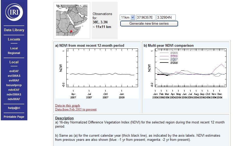
2 Remote Sensing Dr. Pietro Ceccato The International Research Institute for Climate and Society, The Earth Institute, Columbia University


3 Sensing Ultraviolet Infrared Visible spectrum Wavelength (μm) X-Rays Ultraviolet Near-Short Thermal Microwave Infrared Infrared
4 Sensor

 of")
5 An Image An image is composed by pixels which contain values (radiance) of electromagnetic radiation
6

7
8

9 Remote

10 Satellites

11 Geostationary or Polar-Orbiting Satellites

12 Geostationary Satellites Located at about 35,800 km above the equator Orbit at the same speed as earth s rotation Repeat coverage about 15 to 30 minutes Cover full earth disk Observes events and their evolution

13 Polar-Orbiting Satellites 350 to 1000 km height Narrow spatial coverage Less frequent observations
14 Spatial Resolution (Size of the Pixel)

15 Spatial Resolution (5 Km)


16 Spatial Resolution (1 Km)

17 Spatial Resolution (30 m)

18 Spatial Resolution (45 cm)

19 ICTP

20 Environmental Parameters Precipitation Vegetation Temperature Water Bodies
21 Remotely-Sensed Products Precipitation Estimation


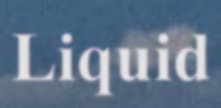
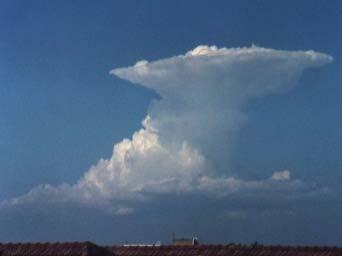
22 What do satellite sensors see? VV, IR & Thermal IR MW (low frequencyemission by rain) MW (high frequency- scattering by ice) ICE Mixed Radar Liquid

23 Geostationary Satellites Located at about 35,800 km above the equator Visible, NIR and Thermal Infrared Repeat coverage about 15 to 30 minutes Observes events and their evolution

 - Swath width: 1400-km - Seven passive MW")
24 Polar-Orbiting Satellites Passive Microwave Defense Meteorological Satellite Program (DMSP) Special Sensor Microwave/Imager (SSM/ I) - Swath width: 1400-km - Seven passive MW channels

25 Radar and Passive Microwave on-board Satellites Tropical Rainfall Measurement Mission (TRMM) - Precipitation radar (PR) km Swath m vertical resolution - TMI - 9-channel MW km swath - VV/IR - Lightening detector trmm.gsfc.nasa.gov

26 Radar and Passive Microwave TRMM product
27 Merging IR, Passive and Active Microwave Rainfall Estimates Combines the best features of both approaches: Good space/time resolution of geostationary estimates Better accuracy of microwave estimates
28 Satellite Rainfall Estimates Products Time Res Space Res Existence PM Gauge CMORPH Daily 0.25 deg 2002-Pres Y N NRL 3-hourly 0.25 deg Y N PERSIANN 3-hourly 0.25 deg Y N TRMM-3B42 3-hourly 0.25 deg 1998-Pres Y Y TRMM-3B42RT 3-hourly 0.25 deg 2002-Pres Y N CPC-RFE Daily 0.1 deg 2001-Pres Y Y CPC-ARC Daily 0.1 deg 1995-Pres N Y GPCP-1DD Daily 1.0 deg 1996-Pres TAMSAT 10-daily ~0.05 deg 1996-Pres N N GPCP Monthly 2.5 deg Y Y CMAP Monthly 2.5 deg Y Y TRMM-3B43 Monthly 2.5 deg 1998-Pres Y Y
 - 1979-2009 (monthly) - 1997-2009 (1DD)")
29 Global Precipitation Climatology Project (GPCP) - Merged satellites with gauge spatial resolution - monthly rain rate - Also 1-degree daily(1dd) (monthly) (1DD)

30 Satellite Products CPC-Merged Analysis of Precipitation (CMAP) - Merged satellites, numerical model predictions and gauge observations CMAP December Climatology( ) spatial resolution - monthly total rain - Also 5-day total From IRI data library SOURCES/.NOAA/.NCEP/.CPC/.Merged_Analysis/.monthly/.latest/.ver 2/.prcp_est/


31 Satellite Products TRMM - Active and passive microwave instruments spatial resolution - monthly total rain - Also 3-hourly current 01_Data_Products/02_Gridded/ 07_Monthly_Other_Data_Source_3B_43/index.html
 spatial resolution - Daily total rainfall - RFE1: 1995-2000 - RFE2: 2002-current")
32 Satellite Products RFE - Merged satellites and gauge (11 km) spatial resolution - Daily total rainfall - RFE1: RFE2: 2002-current

33 Rainfall Products available on IRIS Web Site myresearch/rainfall_2.html
34 Validation of Rainfall Products Validation: Comparing Rainfall Estimates with Rain Gauge Data
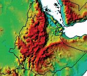

35 Validation of Rainfall Products Ethiopia
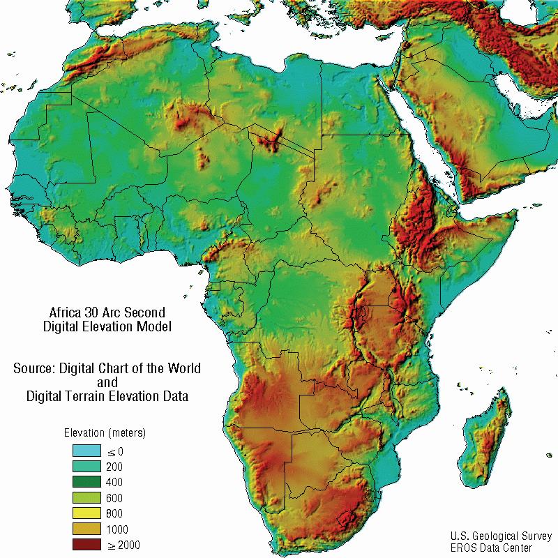
![Validation region and data Validation of Rainfall Products - 120 Stations used - Gauge data gridded using Climate Aided Interpolation - Kriging for interpolating the means 22 35 39 Elevation [meters]](/docs-images/91/105898732/images/36-0.jpg "22 Topography and distribution of gauges. The four 2.5 degree boxes are used for at 2.5 degree resolution, and the number of gauges in each box is given.")
36 Validation region and data Validation of Rainfall Products Stations used - Gauge data gridded using Climate Aided Interpolation - Kriging for interpolating the means Elevation [meters] 22 Topography and distribution of gauges. The four 2.5 degree boxes are used for at 2.5 degree resolution, and the number of gauges in each box is given. Stations in the larger box is used for validation at 1- degree resolution.
37 Validation of Rainfall Products Monthly at 2.5-degree

38 Validation of Rainfall Products 10-day total at 1 o x 1 o
39 Validation of Rainfall Products The following statistics were used to evaluate the accuracy of the rainfall estimate products to retrieve rainfall: coefficient of determination (R 2 ), mean error (ME), standard deviation (Stdv), root mean square error (RMSE), mean absolute error (MAE), and bias. Where R = reference rain gauge observation, G = rainfall estimate product, and N = number of data pairs. ME and MAE are in mm while R 2, Stdv, RMSE and Bias are unit-less.
40 Validation of Rainfall Products Monthly at 2.5-degree Satellite[mm] GPCP_SG CMAP TRMM_3B43 N = 360 GPCP CMAP 3B43 CC Bias ME Gauge[mm] Data:
41 Sep-00 Nov-00 Jan-00 Mar-00 May-00 Jul-00 Nov-99 Sep-99 Validation of Rainfall Products Monthly at 2.5-degree Jan-98 Mar-98 May-98 Jul-98 Sep-98 Nov-98 Jan-99 Mar-99 May-99 Jul-99 Date Gauge GPCP_MS GPCP_SG CMAP Rain[mm]


42 Validation of Rainfall Products 10 Days at 1ºx1º 1 o x 1 o N=306 1DD 3B42 TAMS AT CMO RPH CC Bias ME
43 Validation of Rainfall Products 0.25-deg RFE PERS NRL 3B42 3B42RT CMORPH CC Bias RMS[%] deg RFE 1DD 3B42T 3B42 TAMSAT CMORPH CC Bias RMS[%] deg GPCP CMAP 3B43 CC Bias RMS[%]
44 Improving Rainfall Estimates Calibration: Integrating Rainfall Gauges within Rainfall Estimates Derived from Satellites
,")
, and combined")

45 Improving Rainfall Estimates A B C D Comparison of rain gauge data (A), satellite estimates (B), gauge-only gridded products(c), and combined gauge-satellite product (D), over Ethiopia for 7 July All products have spatial resolution of 0.1 o lat/long

46 Ethiopian Meteorology Agency
47 Remotely-Sensed Products Temperature


48 Air Temperature Land surface temperature retrieval from satellite Thermal IR sensors Longwave radiation Emissivity Shortwave radiation at ground converted in heat (longwave radiation) Land surface (skin) temperature (LST) retrieval from thermal infrared sensors on board geostationary or polar orbiting satellites

49 Air Temperature Comparison between MODIS Night LST and min air T
50 Air Temperature Comparison between MODIS Day LST and max air T


51 Air Temperature Minimum Air Temperature maps from MODIS Land Surface Temperature at night Warmest period Coolest period 18

52
53 Remotely-Sensed Products Vegetation

54 Vegetation Visible spectrum Infrared 10% 50% 100% Chlorophyll absorption Red Channel Multiple-scattering at leaf level Near Infrared Channel


55 Vegetation Visible spectrum Infrared 10% 50% 100% 30% Chlorophyll absorption Red Channel Multiple-scattering at leaf level Near Infrared Channel
56 Vegetation Vegetation Index: NDVI In the Red channel: Low reflectance values = Strong chlorophyll absorption = green vegetation In the NIR channel: High reflectance values = High quantity of biomass Normalised Difference Vegetation Index NDVI= (NIR-Red)/(NIR+Red)
57 Vegetation
58
59 NDVI Study (NIR-Red)/(NIR+Red) NIR NIR channel channel Linear (NDVI 0) Linear (NDVI 0.10) Linear (NDVI 0) Linear (NDVI 0) -0.10) Linear Linear (NDVI (NDVI 0.10) 0) 0) Linear Linear (NDVI (NDVI 0.10) 0.20) 0) Linear (NDVI (NDVI -0.10) Linear (NDVI-0.10) 0.70) Linear (NDVI 0.20) Linear (NDVI 0.80) Linear (NDVI 0.90) Red Red channel channel
60 NDVI Study (NIR-Red)/(NIR+Red) NIR channel Red Red channel vegetation vegetation vegetation sparse vegetation sparse vegetation vegetation sparse bright soils vegetation bright Linear sparse soils (NDVI vegetation 0.60) Linear dark soils (NDVI 0.60) 0.00) Linear bright (NDVI soils 0.00) 0.70) Linear (NDVI 0.70) 0.10) 0.00) Linear dark soils (NDVI 0.10) 0.80) Linear (NDVI 0.80) 0.20) 0.10) Linear (NDVI 0.20) Linear (NDVI 0.20)

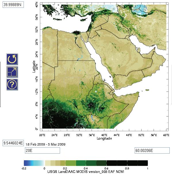
61 NDVI example NDVI shows the presence of vegetation when there is no vegetation in the field


62 NDVI example Problem resolved using RGB composite image NDVI shows the presence of vegetation when there is no vegetation in the field
63 Remotely-Sensed Products Water Bodies

64 Hue as a Qualitative Index The various land cover types have specific ranges of Hue Temporal variations of Hue can be interpreted as a change of land cover type


65 Water Bodies Khartoum Blue Nile White Nile


66 To Obtain Images. 15 Years Ago

67 Today, Images are available via Internet Google Earth, Google Map


68 Today, Images are available via Internet... etc


69 Today, Images are available via Internet

70
School on Modelling Tools and Capacity Building in Climate and Public Health April Rainfall Estimation
 2453-6 School on Modelling Tools and Capacity Building in Climate and Public Health 15-26 April 2013 Rainfall Estimation CECCATO Pietro International Research Institute for Climate and Society, IRI The
Comparison of satellite rainfall estimates with raingauge data for Africa
 Comparison of satellite rainfall estimates with raingauge data for Africa David Grimes TAMSAT Acknowledgements Ross Maidment Teo Chee Kiat Gulilat Tefera Diro TAMSAT = Tropical Applications of Meteorology
Lecture 19: Operational Remote Sensing in Visible, IR, and Microwave Channels
 MET 4994 Remote Sensing: Radar and Satellite Meteorology MET 5994 Remote Sensing in Meteorology Lecture 19: Operational Remote Sensing in Visible, IR, and Microwave Channels Before you use data from any
Ensuring Water in a Changing World
 Ensuring Water in a Changing World Evaluation and application of satellite-based precipitation measurements for hydro-climate studies over mountainous regions: case studies from the Tibetan Plateau Soroosh
Evaluation of Satellite Precipitation Products over the Central of Vietnam
 Evaluation of Satellite Precipitation Products over the Central of Vietnam Long Trinh-Tuan (1), Jun Matsumoto (1,2), Thanh Ngo-Duc (3) (1) Department of Geography, Tokyo Metropolitan University, Japan.
Remote Sensing in Meteorology: Satellites and Radar. AT 351 Lab 10 April 2, Remote Sensing
 Remote Sensing in Meteorology: Satellites and Radar AT 351 Lab 10 April 2, 2008 Remote Sensing Remote sensing is gathering information about something without being in physical contact with it typically
Remote Sensing of Precipitation
 Lecture Notes Prepared by Prof. J. Francis Spring 2003 Remote Sensing of Precipitation Primary reference: Chapter 9 of KVH I. Motivation -- why do we need to measure precipitation with remote sensing instruments?
P4.4 THE COMBINATION OF A PASSIVE MICROWAVE BASED SATELLITE RAINFALL ESTIMATION ALGORITHM WITH AN IR BASED ALGORITHM
 P4.4 THE COMBINATION OF A PASSIVE MICROWAVE BASED SATELLITE RAINFALL ESTIMATION ALGORITHM WITH AN IR BASED ALGORITHM Robert Joyce 1), John E. Janowiak 2), and Phillip A. Arkin 3, Pingping Xie 2) 1) RS
Satellite derived precipitation estimates over Indian region during southwest monsoons
 J. Ind. Geophys. Union ( January 2013 ) Vol.17, No.1, pp. 65-74 Satellite derived precipitation estimates over Indian region during southwest monsoons Harvir Singh 1,* and O.P. Singh 2 1 National Centre
Meteorological Satellite Image Interpretations, Part III. Acknowledgement: Dr. S. Kidder at Colorado State Univ.
 Meteorological Satellite Image Interpretations, Part III Acknowledgement: Dr. S. Kidder at Colorado State Univ. Dates EAS417 Topics Jan 30 Introduction & Matlab tutorial Feb 1 Satellite orbits & navigation
Remote Sensing Applications for Drought Monitoring
 Remote Sensing Applications for Drought Monitoring Amir AghaKouchak Center for Hydrometeorology and Remote Sensing Department of Civil and Environmental Engineering University of California, Irvine Outline
Comparison of NASA AIRS and MODIS Land Surface Temperature and Infrared Emissivity Measurements from the EOS AQUA platform
 Comparison of NASA AIRS and MODIS Land Surface Temperature and Infrared Emissivity Measurements from the EOS AQUA platform Robert Knuteson, Steve Ackerman, Hank Revercomb, Dave Tobin University of Wisconsin-Madison
Indian National (Weather) SATellites for Agrometeorological Applications
 SATellites for Agrometeorological Applications") Indian National (Weather) SATellites for Agrometeorological Applications Bimal K. Bhattacharya Agriculture-Terrestrial Biosphere- Hydrology Group Space Applications Centre (ISRO) Ahmedabad 380015, India
Indian National (Weather) SATellites for Agrometeorological Applications Bimal K. Bhattacharya Agriculture-Terrestrial Biosphere- Hydrology Group Space Applications Centre (ISRO) Ahmedabad 380015, India
Interpretation of Polar-orbiting Satellite Observations. Atmospheric Instrumentation
 Interpretation of Polar-orbiting Satellite Observations Outline Polar-Orbiting Observations: Review of Polar-Orbiting Satellite Systems Overview of Currently Active Satellites / Sensors Overview of Sensor
High resolution spatiotemporal distribution of rainfall seasonality and extreme events based on a 12-year TRMM time series
 High resolution spatiotemporal distribution of rainfall seasonality and extreme events based on a 12-year TRMM time series Bodo Bookhagen, Geography Department, UC Santa Barbara, Santa Barbara, CA 93106-4060
Remote sensing of precipitation extremes
 The panel is about: Understanding and predicting weather and climate extreme Remote sensing of precipitation extremes Climate extreme : (JSC meeting, June 30 2014) IPCC SREX report (2012): Climate Ali
Analyzing and Visualizing Precipitation and Soil Moisture in ArcGIS
 Analyzing and Visualizing Precipitation and Soil Moisture in ArcGIS Wenli Yang, Pham Long, Peisheng Zhao, Steve Kempler, and Jennifer Wei * NASA Goddard Earth Science Data and Information Services Center
Overview and Access to GPCP, TRMM, and GPM Precipitation Data Products
 National Aeronautics and Space Administration ARSET Applied Remote Sensing Training http://arset.gsfc.nasa.gov @NASAARSET Overview and Access to GPCP, TRMM, and GPM Precipitation Data Products www.nasa.gov
Description of Precipitation Retrieval Algorithm For ADEOS II AMSR
 Description of Precipitation Retrieval Algorithm For ADEOS II Guosheng Liu Florida State University 1. Basic Concepts of the Algorithm This algorithm is based on Liu and Curry (1992, 1996), in which the
2009 Progress Report To The National Aeronautics and Space Administration NASA Energy and Water Cycle Study (NEWS) Program
 Program") 2009 Progress Report To The National Aeronautics and Space Administration NASA Energy and Water Cycle Study (NEWS) Program Proposal Title: Grant Number: PI: The Challenges of Utilizing Satellite Precipitation
2009 Progress Report To The National Aeronautics and Space Administration NASA Energy and Water Cycle Study (NEWS) Program Proposal Title: Grant Number: PI: The Challenges of Utilizing Satellite Precipitation
Environmental Remote Sensing GEOG 2021
 Environmental Remote Sensing GEOG 2021 Lecture 3 Spectral information in remote sensing Spectral Information 2 Outline Mechanisms of variations in reflectance Optical Microwave Visualisation/analysis Enhancements/transforms
Global Flood Alert System based on satellite derived rainfall data -Targeting the era of Global Precipitation Measurement (GPM)-
-") Global Flood Alert System based on satellite derived rainfall data -Targeting the era of Global Precipitation Measurement (GPM)- Riko Oki, Misako Kachi (JAXA/EORC) Kazuhiko Fukami (PWRI) and Kazuo Umeda
Global Flood Alert System based on satellite derived rainfall data -Targeting the era of Global Precipitation Measurement (GPM)- Riko Oki, Misako Kachi (JAXA/EORC) Kazuhiko Fukami (PWRI) and Kazuo Umeda
State of the art of satellite rainfall estimation
 State of the art of satellite rainfall estimation 3-year comparison over South America using gauge data, and estimates from IR, TRMM radar and passive microwave Edward J. Zipser University of Utah, USA
Global Precipitation Data Sets
 Global Precipitation Data Sets Rick Lawford (with thanks to Phil Arkin, Scott Curtis, Kit Szeto, Ron Stewart, etc) April 30, 2009 Toronto Roles of global precipitation products in drought studies: 1.Understanding
Once a specific data set is selected, NEO will list related data sets in the panel titled Matching Datasets, which is to the right of the image.
 NASA Earth Observations (NEO): A Brief Introduction NEO is a data visualization tool that allows users to explore a wealth of environmental data collected by NASA satellites. The satellites use an array
REVISION OF THE STATEMENT OF GUIDANCE FOR GLOBAL NUMERICAL WEATHER PREDICTION. (Submitted by Dr. J. Eyre)
") WORLD METEOROLOGICAL ORGANIZATION Distr.: RESTRICTED CBS/OPAG-IOS (ODRRGOS-5)/Doc.5, Add.5 (11.VI.2002) COMMISSION FOR BASIC SYSTEMS OPEN PROGRAMME AREA GROUP ON INTEGRATED OBSERVING SYSTEMS ITEM: 4 EXPERT
WORLD METEOROLOGICAL ORGANIZATION Distr.: RESTRICTED CBS/OPAG-IOS (ODRRGOS-5)/Doc.5, Add.5 (11.VI.2002) COMMISSION FOR BASIC SYSTEMS OPEN PROGRAMME AREA GROUP ON INTEGRATED OBSERVING SYSTEMS ITEM: 4 EXPERT
July 1987 December 2002
 16 October 2006 GLOBAL PRECIPITATION DATA SETS George J. Huffman 1 Table 1. Summary of publicly available, quasi-operational, quasi-global precipitation estimates from a single sensor type. Where appropriate,
Spatial Downscaling of TRMM Precipitation Using DEM. and NDVI in the Yarlung Zangbo River Basin
 Spatial Downscaling of TRMM Precipitation Using DEM and NDVI in the Yarlung Zangbo River Basin Yang Lu 1,2, Mingyong Cai 1,2, Qiuwen Zhou 1,2, Shengtian Yang 1,2 1 State Key Laboratory of Remote Sensing
C. Jimenez, C. Prigent, F. Aires, S. Ermida. Estellus, Paris, France Observatoire de Paris, France IPMA, Lisbon, Portugal
 All-weather land surface temperature estimates from microwave satellite observations, over several decades and real time: methodology and comparison with infrared estimates C. Jimenez, C. Prigent, F. Aires,
APPENDIX 2 OVERVIEW OF THE GLOBAL PRECIPITATION MEASUREMENT (GPM) AND THE TROPICAL RAINFALL MEASURING MISSION (TRMM) 2-1
 AND THE TROPICAL RAINFALL MEASURING MISSION (TRMM) 2-1") APPENDIX 2 OVERVIEW OF THE GLOBAL PRECIPITATION MEASUREMENT (GPM) AND THE TROPICAL RAINFALL MEASURING MISSION (TRMM) 2-1 1. Introduction Precipitation is one of most important environmental parameters.
APPENDIX 2 OVERVIEW OF THE GLOBAL PRECIPITATION MEASUREMENT (GPM) AND THE TROPICAL RAINFALL MEASURING MISSION (TRMM) 2-1 1. Introduction Precipitation is one of most important environmental parameters.
Land Data Assimilation at NCEP NLDAS Project Overview, ECMWF HEPEX 2004
 Dag.Lohmann@noaa.gov, Land Data Assimilation at NCEP NLDAS Project Overview, ECMWF HEPEX 2004 Land Data Assimilation at NCEP: Strategic Lessons Learned from the North American Land Data Assimilation System
Lecture 4b: Meteorological Satellites and Instruments. Acknowledgement: Dr. S. Kidder at Colorado State Univ.
 Lecture 4b: Meteorological Satellites and Instruments Acknowledgement: Dr. S. Kidder at Colorado State Univ. US Geostationary satellites - GOES (Geostationary Operational Environmental Satellites) US
Long-Term Time Series of Water Vapour Total Columns from GOME, SCIAMACHY and GOME-2
 Graphics: ESA Graphics: ESA Graphics: ESA Long-Term Time Series of Water Vapour Total Columns from GOME, SCIAMACHY and GOME-2 S. Noël, S. Mieruch, H. Bovensmann, J. P. Burrows Institute of Environmental
REMOTELY SENSED INFORMATION FOR CROP MONITORING AND FOOD SECURITY
 REMOTELY SENSED INFORMATION FOR CROP LEARNING OBJECTIVES Lesson 2 Commonly Used Remote Sensing Data At the end of the lesson, you will be able to: recognize the types of data most commonly used in remote
Retrieval of precipitation from Meteosat-SEVIRI geostationary satellite observations
 Retrieval of precipitation from Meteosat-SEVIRI geostationary satellite observations Jan Fokke Meirink, Hidde Leijnse (KNMI) Rob Roebeling (EUMETSAT) Overview Introduction Algorithm description Validation
Correcting Microwave Precipitation Retrievals for near- Surface Evaporation
 Correcting Microwave Precipitation Retrievals for near- Surface Evaporation The MIT Faculty has made this article openly available. Please share how this access benefits you. Your story matters. Citation
MAIN ATTRIBUTES OF THE PRECIPITATION PRODUCTS DEVELOPED BY THE HYDROLOGY SAF PROJECT RESULTS OF THE VALIDATION IN HUNGARY
 MAIN ATTRIBUTES OF THE PRECIPITATION PRODUCTS DEVELOPED BY THE HYDROLOGY SAF PROJECT RESULTS OF THE VALIDATION IN HUNGARY Eszter Lábó OMSZ-Hungarian Meteorological Service, Budapest, Hungary labo.e@met.hu
MSG system over view
 MSG system over view 1 Introduction METEOSAT SECOND GENERATION Overview 2 MSG Missions and Services 3 The SEVIRI Instrument 4 The MSG Ground Segment 5 SAF Network 6 Conclusions METEOSAT SECOND GENERATION
THE RAINWATER HARVESTING SYMPOSIUM 2015
 THE RAINWATER HARVESTING SYMPOSIUM 2015 Remote Sensing for Rainwater Harvesting and Recharge Estimation under Data Scarce Conditions Taye Alemayehu Ethiopian Institute of Water Resources, Metameta Research
Eric. W. Harmsen 1, John Mecikalski 2, Vanessa Acaron 3 and Jayson Maldonado 3
 Estimating Ground-Level Solar Radiation and Evapotranspiration In Puerto Rico Using Satellite Remote Sensing Eric. W. Harmsen 1, John Mecikalski 2, Vanessa Acaron 3 and Jayson Maldonado 3 1 Department
Judit Kerényi. OMSZ-Hungarian Meteorological Service P.O.Box 38, H-1525, Budapest Hungary Abstract
 Comparison of the precipitation products of Hydrology SAF with the Convective Rainfall Rate of Nowcasting-SAF and the Multisensor Precipitation Estimate of EUMETSAT Judit Kerényi OMSZ-Hungarian Meteorological
Director: Soroosh Sorooshian
 Director: Soroosh Sorooshian X. Gao B. Imam K. Hsu S. O Rourke D. Hohnbaum J. Li G.H. Park D. Braithwaite E. Pritchard B. Khakbaz W. Chu A. Behrangi Alex R. Sutlana Joey A. Zahraei Developing state-of-the-art
Jun Park National Meteorological Satellite Center Korea Meteorological Administration
 KMA Implementation Plan for Satellite Climate products Jun Park National Meteorological Satellite Center Korea Meteorological Administration jun.park@kma.go.kr Outline 1. Introduction : Current & Future
THE EVALUATION OF A PASSIVE MICROWAVE-BASED SATELLITE RAINFALL ESTIMATION ALGORITHM WITH AN IR BASED ALGORITHM AT SHORT TIME SCALES
 THE EVALUATION OF A PASSIVE MICROWAVE-BASED SATELLITE RAINFALL ESTIMATION ALGORITHM WITH AN IR BASED ALGORITHM AT SHORT TIME SCALES Robert Joyce 1, John E. Janowiak 2, Phillip A. Arkin 3, Pingping Xie
Operational systems for SST products. Prof. Chris Merchant University of Reading UK
 Operational systems for SST products Prof. Chris Merchant University of Reading UK Classic Images from ATSR The Gulf Stream ATSR-2 Image, ƛ = 3.7µm Review the steps to get SST using a physical retrieval
F O U N D A T I O N A L C O U R S E
 F O U N D A T I O N A L C O U R S E December 6, 2018 Satellite Foundational Course for JPSS (SatFC-J) F O U N D A T I O N A L C O U R S E Introduction to Microwave Remote Sensing (with a focus on passive
CHAPTER VII COMPARISON OF SATELLITE (TRMM) PRECIPITATION DATA WITH GROUND-BASED DATA
 PRECIPITATION DATA WITH GROUND-BASED DATA") CHAPTER VII COMPARISON OF SATELLITE () PRECIPITATION DATA WITH GROUND-BASED DATA CHAPTER VII COMPARISON OF SATELLITE () PRECIPITATION DATA WITH GROUND-BASED DATA 7.1. INTRODUCTION Most of the earth s rain
CHAPTER VII COMPARISON OF SATELLITE () PRECIPITATION DATA WITH GROUND-BASED DATA CHAPTER VII COMPARISON OF SATELLITE () PRECIPITATION DATA WITH GROUND-BASED DATA 7.1. INTRODUCTION Most of the earth s rain
Analysing Land Surface Emissivity with Multispectral Thermal Infrared Data
 2nd Workshop on Remote Sensing and Modeling of Surface Properties 9-11 June 2009, Météo France, Toulouse, France Analysing Land Surface Emissivity with Multispectral Thermal Infrared Data Maria Mira, Thomas
Welcome and Introduction
 Welcome and Introduction Riko Oki Earth Observation Research Center (EORC) Japan Aerospace Exploration Agency (JAXA) 7th Workshop of International Precipitation Working Group 17 November 2014 Tsukuba International
Interannual variation of MODIS NDVI in Lake Taihu and its relation to climate in submerged macrophyte region
 Yale-NUIST Center on Atmospheric Environment Interannual variation of MODIS NDVI in Lake Taihu and its relation to climate in submerged macrophyte region ZhangZhen 2015.07.10 1 Outline Introduction Data
Estimation of Wavelet Based Spatially Enhanced Evapotranspiration Using Energy Balance Approach
 Estimation of Wavelet Based Spatially Enhanced Evapotranspiration Using Energy Balance Approach Dr.Gowri 1 Dr.Thirumalaivasan 2 1 Associate Professor, Jerusalem College of Engineering, Department of Civil
Application of Himawari-8 AHI Data to the GOES-R Rainfall Rate Algorithm
 Application of Himawari-8 AHI Data to the GOES-R Rainfall Rate Algorithm Yaping Li 1, Robert Kuligowski 2 and Yan Hao 1 1. IMSG at NOAA/NESDIS/STAR 2. NOAA/NESDIS/STAR, College Park, MD 1 GOES-R Baseline
TIROS-1. 1) National Aeronautics and Space Administration 2) National Oceanic and Atmospheric Administration
 National Aeronautics and Space Administration 2) National Oceanic and Atmospheric Administration") NOAA TIROS-1 NASA 1) National Aeronautics and Space Administration 2) National Oceanic and Atmospheric Administration Sputnik Sputlink Aerobee Aerobee TIROS-1 TIROS-1 1) Spiral swirl SeaWIFS Orb View2
NOAA TIROS-1 NASA 1) National Aeronautics and Space Administration 2) National Oceanic and Atmospheric Administration Sputnik Sputlink Aerobee Aerobee TIROS-1 TIROS-1 1) Spiral swirl SeaWIFS Orb View2
Differences between East and West Pacific Rainfall Systems
 15 DECEMBER 2002 BERG ET AL. 3659 Differences between East and West Pacific Rainfall Systems WESLEY BERG, CHRISTIAN KUMMEROW, AND CARLOS A. MORALES Department of Atmospheric Science, Colorado State University,
Assessment of Precipitation Characters between Ocean and Coast area during Winter Monsoon in Taiwan
 Assessment of Precipitation Characters between Ocean and Coast area during Winter Monsoon in Taiwan Peter K.H. Wang Central Weather Bureau Abstract SSM/I has been applied in derivation of liquid water
"Cloud and Rainfall Observations using Microwave Radiometer Data and A-priori Constraints" Christian Kummerow and Fang Wang Colorado State University
 "Cloud and Rainfall Observations using Microwave Radiometer Data and A-priori Constraints" Christian Kummerow and Fang Wang Colorado State University ECMWF-JCSDA Workshop Reading, England June 16-18, 2010
Studying snow cover in European Russia with the use of remote sensing methods
 40 Remote Sensing and GIS for Hydrology and Water Resources (IAHS Publ. 368, 2015) (Proceedings RSHS14 and ICGRHWE14, Guangzhou, China, August 2014). Studying snow cover in European Russia with the use
Quantitative Precipitation Estimation using Satellite and Ground Measurements
 Quantitative Precipitation Estimation using Satellite and Ground Measurements Kuolin Hsu Center for Hydrometeorology and Remote Sensing University of California Irvine XVII Congress of the Spanish Association
THE EUMETSAT MULTI-SENSOR PRECIPITATION ESTIMATE (MPE)
") THE EUMETSAT MULTI-SENSOR PRECIPITATION ESTIMATE (MPE) Thomas Heinemann, Alessio Lattanzio and Fausto Roveda EUMETSAT Am Kavalleriesand 31, 64295 Darmstadt, Germany ABSTRACT The combination of measurements
THE EUMETSAT MULTI-SENSOR PRECIPITATION ESTIMATE (MPE) Thomas Heinemann, Alessio Lattanzio and Fausto Roveda EUMETSAT Am Kavalleriesand 31, 64295 Darmstadt, Germany ABSTRACT The combination of measurements
Introduction to Electromagnetic Radiation and Radiative Transfer
 Introduction to Electromagnetic Radiation and Radiative Transfer Temperature Dice Results Visible light, infrared (IR), ultraviolet (UV), X-rays, γ-rays, microwaves, and radio are all forms of electromagnetic
A Time Lag Model to Estimate Rainfall Rate Based on GOES Data
 A Time Lag Model to Estimate Rainfall Rate Based on GOES Data Nazario D. Ramirez, Robert J. Kuligowski, and Joan M. Castro Octava Reunión Nacional de Percepción Remota y Sistemas Geográficos de Información
GCOM-W1 now on the A-Train
 GCOM-W1 now on the A-Train GCOM-W1 Global Change Observation Mission-Water Taikan Oki, K. Imaoka, and M. Kachi JAXA/EORC (& IIS/The University of Tokyo) Mini-Workshop on A-Train Science, March 8 th, 2013
Joint International Surface Working Group and Satellite Applications Facility on Land Surface Analysis Workshop, IPMA, Lisboa, June 2018
 Joint International Surface Working Group and Satellite Applications Facility on Land Surface Analysis Workshop, IPMA, Lisboa, 26-28 June 2018 Introduction Soil moisture Evapotranspiration Future plan
Remote Sensing of Snow and Ice. Lecture 21 Nov. 9, 2005
 Remote Sensing of Snow and Ice Lecture 21 Nov. 9, 2005 Topics Remote sensing snow depth: passive microwave (covered in Lecture 14) Remote sensing sea ice and ice sheet elevation change: Lidar - ICESat
Performance of High Resolution Satellite Rainfall Products over Data Scarce Parts of Eastern Ethiopia
 Florida International University FIU Digital Commons Department of Earth and Environment College of Arts, Sciences & Education 9-11-2015 Performance of High Resolution Satellite Rainfall Products over
DERIVED FROM SATELLITE DATA
 P6.17 INTERCOMPARISON AND DIAGNOSIS OF MEI-YU RAINFALL DERIVED FROM SATELLITE DATA Y. Zhou * Department of Meteorology, University of Maryland, College Park, Maryland P. A. Arkin ESSIC, University of Maryland,
Comparison of NASA AIRS and MODIS Land Surface Temperature and Infrared Emissivity Measurements from the EOS AQUA platform
 Comparison of NASA AIRS and MODIS Land Surface Temperature and Infrared Emissivity Measurements from the EOS AQUA platform Robert Knuteson, Hank Revercomb, Dave Tobin University of Wisconsin-Madison 16
COMBINATION OF SATELLITE PRECIPITATION ESTIMATES AND RAIN GAUGE FOR HIGH SPATIAL AND TEMPORAL RESOLUTIONS INTRODUCTION
 COMBINATION OF SATELLITE PRECIPITATION ESTIMATES AND RAIN GAUGE FOR HIGH SPATIAL AND TEMPORAL RESOLUTIONS Ferreira, Rute Costa¹ ; Herdies, D. L.¹; Vila, D.A.¹; Beneti, C.A. A.² ¹ Center for Weather Forecasts
LAND SURFACE TEMPERATURE VALIDATION WITH IN SITU MEASUREMENTS
 LAND SURFACE TEMPERATURE VALIDATION WITH IN SITU MEASUREMENTS Group 7 Juan Manuel González Cantero Irene Grimaret Rincón Alex Webb Advisor: Darren Ghent Research problem The project task is to design an
APPLICATIONS WITH METEOROLOGICAL SATELLITES. W. Paul Menzel. Office of Research and Applications NOAA/NESDIS University of Wisconsin Madison, WI
 APPLICATIONS WITH METEOROLOGICAL SATELLITES by W. Paul Menzel Office of Research and Applications NOAA/NESDIS University of Wisconsin Madison, WI July 2004 Unpublished Work Copyright Pending TABLE OF CONTENTS
Current Status of the Stratospheric Ozone Layer From: UNEP Environmental Effects of Ozone Depletion and Its Interaction with Climate Change
 Goals Produce a data product that allows users to acquire time series of the distribution of UV-B radiation across the continental USA, based upon measurements from the UVMRP. Provide data in a format
TRMM Multi-satellite Precipitation Analysis (TMPA)
") TRMM Multi-satellite Precipitation Analysis (TMPA) (sometimes known as 3B42/43, TRMM product numbers) R. Adler, G. Huffman, D. Bolvin, E. Nelkin, D. Wolff NASA/Goddard Laboratory for Atmospheres with key
TRMM Multi-satellite Precipitation Analysis (TMPA) (sometimes known as 3B42/43, TRMM product numbers) R. Adler, G. Huffman, D. Bolvin, E. Nelkin, D. Wolff NASA/Goddard Laboratory for Atmospheres with key
Rainfall estimation over the Taiwan Island from TRMM/TMI data
 P1.19 Rainfall estimation over the Taiwan Island from TRMM/TMI data Wann-Jin Chen 1, Ming-Da Tsai 1, Gin-Rong Liu 2, Jen-Chi Hu 1 and Mau-Hsing Chang 1 1 Dept. of Applied Physics, Chung Cheng Institute
Flux Tower Data Quality Analysis in the North American Monsoon Region
 Flux Tower Data Quality Analysis in the North American Monsoon Region 1. Motivation The area of focus in this study is mainly Arizona, due to data richness and availability. Monsoon rains in Arizona usually
Asian Precipitation -- Highly Resolved Observational Data Integration Towards Evaluation of the Water Resources (APHRODITE s Water Resources)
") PHERPP Meeting (3-5December 2007) WMO (Geneva) Asian Precipitation -- Highly Resolved Observational Data Integration Towards Evaluation of the Water Resources (APHRODITE s Water Resources) Akiyo Yatagai
PHERPP Meeting (3-5December 2007) WMO (Geneva) Asian Precipitation -- Highly Resolved Observational Data Integration Towards Evaluation of the Water Resources (APHRODITE s Water Resources) Akiyo Yatagai
Model errors in tropical cloud and precipitation revealed by the assimilation of MW imagery
 Model errors in tropical cloud and precipitation revealed by the assimilation of MW imagery Katrin Lonitz, Alan Geer, Philippe Lopez + many other colleagues 20 November 2014 Katrin Lonitz ( ) Tropical
Remote sensing of sea ice
 Remote sensing of sea ice Ice concentration/extent Age/type Drift Melting Thickness Christian Haas Remote Sensing Methods Passive: senses shortwave (visible), thermal (infrared) or microwave radiation
D. Cimini*, V. Cuomo*, S. Laviola*, T. Maestri, P. Mazzetti*, S. Nativi*, J. M. Palmer*, R. Rizzi and F. Romano*
 D. Cimini*, V. Cuomo*, S. Laviola*, T. Maestri, P. Mazzetti*, S. Nativi*, J. M. Palmer*, R. Rizzi and F. Romano* * Istituto di Metodologie per l Analisi Ambientale, IMAA/CNR, Potenza, Italy ADGB - Dip.
Drought and its effect on vegetation, comparison of NDVI for drought and non-drought years related to Land use classifications
 Drought and its effect on vegetation, comparison of NDVI for drought and non-drought years related to Land use classifications Jabbari *, S., Khajeddin, S. J. Jafari, R, Soltani, S and Riahi, F s.jabbari_62@yahoo.com
Radiative Transfer Model based Bias Correction in INSAT-3D/3DR Thermal Observations to Improve Sea Surface Temperature Retrieval
 Radiative Transfer Model based Bias Correction in INSAT-3D/3DR Thermal Observations to Improve Sea Surface Temperature Retrieval Rishi K Gangwar, Buddhi P Jangid, and Pradeep K Thapliyal Space Applications
AMS copyrighted work
 AMS copyrighted work Copyright 2014 American Meteorological Society (AMS). Permission to use figures, tables, and brief excerpts from this work in scientific and educational works is hereby granted provided
Assimilation of satellite derived soil moisture for weather forecasting
 Assimilation of satellite derived soil moisture for weather forecasting www.cawcr.gov.au Imtiaz Dharssi and Peter Steinle February 2011 SMOS/SMAP workshop, Monash University Summary In preparation of the
Blended Sea Surface Winds Product
 1. Intent of this Document and POC Blended Sea Surface Winds Product 1a. Intent This document is intended for users who wish to compare satellite derived observations with climate model output in the context
Influence of Clouds and Aerosols on the Earth s Radiation Budget Using Clouds and the Earth s Radiant Energy System (CERES) Measurements
 Measurements") Influence of Clouds and Aerosols on the Earth s Radiation Budget Using Clouds and the Earth s Radiant Energy System (CERES) Measurements Norman G. Loeb Hampton University/NASA Langley Research Center Bruce
Influence of Clouds and Aerosols on the Earth s Radiation Budget Using Clouds and the Earth s Radiant Energy System (CERES) Measurements Norman G. Loeb Hampton University/NASA Langley Research Center Bruce
Combined use of satellite estimates and rain gauge observations to generate high-quality historical rainfall time series over Ethiopia
 INTERNATIONAL JOURNAL OF CLIMATOLOGY Int. J. Climatol. 34: 2489 2504 (2014) Published online 21 November 2013 in Wiley Online Library (wileyonlinelibrary.com) DOI: 10.1002/joc.3855 Combined use of satellite
Evaluation of GPM Precipitation Estimates for Land Data Assimilation Applications
 Evaluation of GPM Precipitation Estimates for Land Data Assimilation Applications PI: Prof. Lori Bruce, Ph.D Mississippi State University GeoResources Institute RPC Review (04/14/08) 1 GPM Evaluation Team
FUNDAMENTALS OF REMOTE SENSING FOR RISKS ASSESSMENT. 1. Introduction
 FUNDAMENTALS OF REMOTE SENSING FOR RISKS ASSESSMENT FRANÇOIS BECKER International Space University and University Louis Pasteur, Strasbourg, France; E-mail: becker@isu.isunet.edu Abstract. Remote sensing
GLOBAL SATELLITE MAPPING OF PRECIPITATION (GSMAP) PROJECT
 PROJECT") GLOBAL SATELLITE MAPPING OF PRECIPITATION (GSMAP) PROJECT Tomoo Ushio 1, Kazumasa Aonashi 2, Takuji Kubota 3, Shoichi Shige 4, Misako Kachi 3, Riko Oki 3, Ken ichi Okamoto 5, Satoru Yoshida 1, Zen-Ichiro
GLOBAL SATELLITE MAPPING OF PRECIPITATION (GSMAP) PROJECT Tomoo Ushio 1, Kazumasa Aonashi 2, Takuji Kubota 3, Shoichi Shige 4, Misako Kachi 3, Riko Oki 3, Ken ichi Okamoto 5, Satoru Yoshida 1, Zen-Ichiro
THE LAND-SAF SURFACE ALBEDO AND DOWNWELLING SHORTWAVE RADIATION FLUX PRODUCTS
 THE LAND-SAF SURFACE ALBEDO AND DOWNWELLING SHORTWAVE RADIATION FLUX PRODUCTS Bernhard Geiger, Dulce Lajas, Laurent Franchistéguy, Dominique Carrer, Jean-Louis Roujean, Siham Lanjeri, and Catherine Meurey
Determination of the NDSI index and cloud mask algorithm (The Case Study: Sepidan Region, Iran)
") 2012 International Conference on Future Environment and Energy IPCBEE vol.28(2012) (2012)IACSIT Press, Singapoore Determination of the NDSI index and cloud mask algorithm (The Case Study: Sepidan Region,
2012 International Conference on Future Environment and Energy IPCBEE vol.28(2012) (2012)IACSIT Press, Singapoore Determination of the NDSI index and cloud mask algorithm (The Case Study: Sepidan Region,
Applications of yield monitoring systems and agricultural statistics in agricultural (re)insurance
insurance") Image: used under license from shutterstock.com Applications of yield monitoring systems and agricultural statistics in agricultural (re)insurance 18 October 2018 Ernst Bedacht Agenda Introduction 1. Munich
Image: used under license from shutterstock.com Applications of yield monitoring systems and agricultural statistics in agricultural (re)insurance 18 October 2018 Ernst Bedacht Agenda Introduction 1. Munich
Long-term Water Cycle Observation by the Advanced Microwave Scanning Radiometer (AMSR) Series: AMSR-E, AMSR2 and Follow-on
 Series: AMSR-E, AMSR2 and Follow-on") Long-term Water Cycle Observation by the Advanced Microwave Scanning Radiometer (AMSR) Series: AMSR-E, AMSR2 and Follow-on M. Kachi 1), H. Fujii 1), T. Kubota 1), T. Maeda 1), N. Ono 1), M. Kasahara 1),
Long-term Water Cycle Observation by the Advanced Microwave Scanning Radiometer (AMSR) Series: AMSR-E, AMSR2 and Follow-on M. Kachi 1), H. Fujii 1), T. Kubota 1), T. Maeda 1), N. Ono 1), M. Kasahara 1),
NOAA/NESDIS Tropical Web Page with LEO Satellite Products and Applications for Forecasters
 NOAA/NESDIS Tropical Web Page with LEO Satellite Products and Applications for Forecasters Sheldon Kusselson National Oceanic and Atmospheric Administration (NOAA) National Environmental Satellite Data
The Australian Operational Daily Rain Gauge Analysis
 The Australian Operational Daily Rain Gauge Analysis Beth Ebert and Gary Weymouth Bureau of Meteorology Research Centre, Melbourne, Australia e.ebert@bom.gov.au Daily rainfall data and analysis procedure
Overview of Long- term Observa3ons of the Global Water Cycle by the Advanced Microwave Scanning Radiometer (AMSR) Series
 Series") Overview of Long- term Observa3ons of the Global Water Cycle by the Advanced Microwave Scanning Radiometer (AMSR) Series M. Kachi 1), T. Maeda 1), N. Ono 1), M. Kasahara 1), N. Ebuchi 1),2), and H. Shimoda
Overview of Long- term Observa3ons of the Global Water Cycle by the Advanced Microwave Scanning Radiometer (AMSR) Series M. Kachi 1), T. Maeda 1), N. Ono 1), M. Kasahara 1), N. Ebuchi 1),2), and H. Shimoda
Abebe Sine Gebregiorgis, PhD Postdoc researcher. University of Oklahoma School of Civil Engineering and Environmental Science
 Abebe Sine Gebregiorgis, PhD Postdoc researcher University of Oklahoma School of Civil Engineering and Environmental Science November, 2014 MAKING SATELLITE PRECIPITATION PRODUCTS WORK FOR HYDROLOGIC APPLICATION
Principles of Radiative Transfer Principles of Remote Sensing. Marianne König EUMETSAT
 - Principles of Radiative Transfer Principles of Remote Sensing Marianne König EUMETSAT marianne.koenig@eumetsat.int Remote Sensing All measurement processes which perform observations/measurements of
A satellite-based long-term Land Surface Temperature Climate Data Record
 Federal Department of Home Affairs FDHA Federal Office of Meteorology and Climatology MeteoSwiss A satellite-based long-term Land Surface Temperature Climate Data Record, Virgílio A. Bento, Frank M. Göttsche,
Advanced Geostationary Observations for the OzEWEX Community. Leon Majewski Bureau of Meteorology
 Advanced Geostationary Observations for the OzEWEX Community Leon Majewski Bureau of Meteorology Overview Geostationary satellite missions & sensors Meteorological applications Access for OzEWEX researchers
Super-resolution of MTSAT Land Surface Temperature by Blending MODIS and AVNIR2
 Super-resolution of MTSAT Land Surface Temperature by Blending MODIS and AVNIR2 Wataru Takeuchi 1*, Kei Oyoshi 2 and Shin Akatsuka 3 1 Institute of Industrial Science, University of Tokyo, Japan (6-1,