Remote Sensing of Snow and Ice. Lecture 21 Nov. 9, 2005
|
|
|
- Abner Arnold
- 6 years ago
- Views:
Transcription
1 Remote Sensing of Snow and Ice Lecture 21 Nov. 9, 2005
2 Topics Remote sensing snow depth: passive microwave (covered in Lecture 14) Remote sensing sea ice and ice sheet elevation change: Lidar - ICESat (covered in Lecture 15) Remote sensing snow cover based on MODIS (covered in this lecture)
3 MODIS data-product sequence Input MODIS Level 1B bands 1, 2, 4, 6 (MOD02_HKM ), 31 & 32 ( MOD02_1km) Input MODIS 1-km resolution geolocation, cloud mask MOD35 and land/water mask MOD03 Calculate NDSI, NDVI, grouped-criteria tests, vegetation polygon Apply surface temperature screen ( 283K) 8-day composite snow tile product 500-m resolution MOD10A2 8-day composite snow CMG 0.05 resolution MOD10C2 Swath snow 500-m product MOD10_L2 (includes FSC) Daily snow tile product 500-m resolution MOD10A1 (includes daily snow albedo) Daily snow CMG 0.05 resolution MOD10C1 Algorithm Heritage: Kyle et al., 1978 Bunting and d Entremont, 1982 Crane and Anderson, 1984 Tucker et al., 1985 Dozier, 1989 Romanov et al., 2000 Monthly snow CMG 0.05 resolution MOD10CM Source: Hall, 2004

 and snow map (right)")
4 MOD10_L2: Level 2, 500-m swath product of California and the western U.S., October 31, 2004 MODIS true-color image (left - bands 1, 4, 3) and snow map (right) Source: Hall, 2004

 MOD10A1 (Snow Daily Tile Product)")
5 MOD10A1: Daily Tile Snow Map Snow in northern Italy - March 29, 2002 snow cloud MOD09 bands 1,4,3 (Surface Reflectance Product) MOD10A1 (Snow Daily Tile Product) Source: Hall, 2004

6 Daily snow albedo product (MOD10A1) 500-m m resolution Snow albedo swaths - North America Nov. 22, 2003 Nov. 27, 2003 Albedo (%) Klein, 2003 Source: Hall, 2004

 Source:")
7 MOD10A2: 8-day Composite Tile Snow Map Western North America - April 23, 2002 MOD09 bands 1,4,3 (Surface Reflectance Product) MOD10A2 (Snow 8-Day Tile Product) Source: Hall, 2004
8 MOD10A1 snow product represents an improvement over the NOHRSC operational snow product in many areas Missouri River basin Columbia River basin From Maurer et al. (2003) Source: Hall, 2004
")
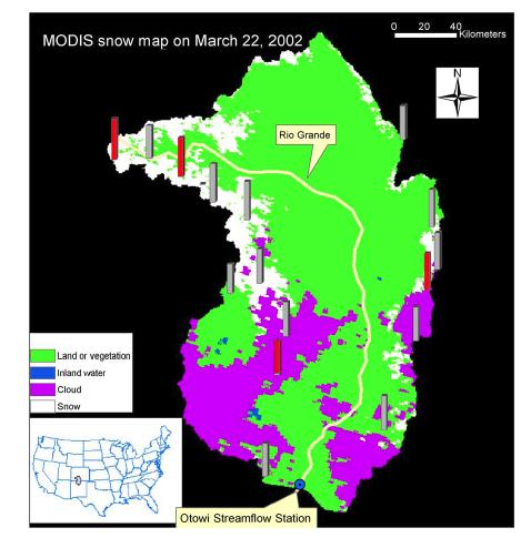
9 Upper Rio Grand Basin in Colorado and New Mexico Agreement between the MODIS and NOHRSC snow maps was 86% for the 2000 to 2001 snow season Klein & Barnett (2003)
 April 25, 2004 Percent Snow Cover")
10 MOD10C1: Daily CMG snow map (0.05º resolution) April 25, 2004 Percent Snow Cover Source: Hall, 2004
11 MOD10C2: 8-Day Composite CMG snow map fractional snow cover from 1-100% not shown April 6-13, 2000 March 6-13, 2002 The 8-day composite CMG maps maximize snow cover and minimize cloud cover for the compositing period Source: Hall, 2004
 Snow Maps")
12 MOD10CM: 0.05 Monthly Climate-Modeling Grid (CMG) Snow Maps February 2004 Percent Snow Cover Source: Hall, 2004

13 Applications of MODIS snow data in Afghanistan for the Famine Early Warning System (FEWS) The map on the top illustrates the current year snow conditions while the map on the bottom shows the snow extent for the same 8-day MODIS period from last year. Courtesy Michael Budde/USGS
 in terms of the snow extent identified using MODIS.")
14 Merged MODIS Snow Cover Extent and AFWA Snow Depth Daily snow depth values from the Air Force Weather Agency (AFWA) and NOAA are used to create a maximum 8-day snow depth corresponding to the MODIS composite period. These two data sources are then merged to produce a product that identifies snow depth (AFWA) in terms of the snow extent identified using MODIS. The merged product maintains the spatial resolution of MODIS and provides snow depth measurements. Courtesy Michael Budde/USGS


15 Greenland Enhanced algorithm will separate land, bare ice and snow-covered ice in the daily product, MOD10A1 MOD10C2 Source: Hall, 2004 April 6-13, 2000
 Enhanced Source:")
16 Greenland July 7, 2002 True color composite (1,4,3) Enhanced Source: Hall, 2004

17 Greenland July 7, 2002 True color composite (1,4,3) Supervised classification Image processing by Kimberly Casey Source: Hall, 2004
 1, 4, 6")


18 West Coast of Greenland June 22, 2004 (1510 UTC) 1, 4, 6 calibrated radiance supervised classification Unsupervised classification Source: Hall, 2004 Image processing by Kimberly Casey

 75,000 NM Elephant Butt")
19 A Case Study in New Mexico Evapotranspiration Precipitation 73,000 (97.3%) 75,000 NM Elephant Butt Reservoir Zhu, Xie, and Hendrickx, 2005

20 Reduced Water in Reservoir over Time


21 Land-no snow Inland water Cloud obscured Snow New Mexico 2/26/00 2/26/00 3/13/00 4/14/00 5/8/00 6/1/00
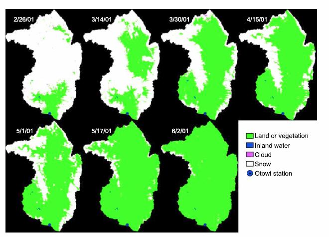
22

23 MODIS 8-day 8 Snow Cover over Time 20% of decrease
24 Time series of the 8-day MODIS snow cover of Upper Rio Grande river basin and the corresponding 8-day mean streamflow at Otowi gauge station.
25 Outliers due to the rain storm. If removed, r =
26 No outlier in 2002, better correlation achieved
27
28

29 Overall accuracy: % to 56.8%, MODIS daily product % to 92.3%, MODIS 8-day product
30 Conclusions (1) the MODIS 8-day product has higher classification accuracy for both snow and land; (2) the omission error of misclassifying snow as land is similar for both products, both are low; (3) the MODIS 8-day product has a slightly higher commission error of misclassifying land as snow than the MODIS daily product; and (4) the MODIS daily product has higher omission errors of misclassifying both snow and land as clouds. (5) Clouds are the major cause for reduction of the overall accuracy of the MODIS daily product. Improvement in suppressing clouds in the 8-day product is obvious from this comparison study. The sacrifice is the temporal resolution that is reduced from 1 to 8 days. (6) For clear sky days, the MODIS daily algorithm works quite well or even better than the MODIS 8-day algorithm.
MODIS Snow Products Collection 6 User Guide. George A. Riggs Dorothy K. Hall
 MODIS Snow Products Collection 6 User Guide George A. Riggs Dorothy K. Hall 11 December 2015 Table of Contents Overview... 5 New Snow Cover Data Products in C6... 7 Revisions in C6 Snow Cover Products...
NIDIS Intermountain West Drought Early Warning System April 16, 2019
 NIDIS Intermountain West Drought Early Warning System April 16, 2019 Precipitation The images above use daily precipitation statistics from NWS COOP, CoCoRaHS, and CoAgMet stations. From top to bottom,
Statistical evaluation of remotely sensed snow-cover products with constraints from streamflow and SNOTEL measurements
 Remote Sensing of Environment 94 (2005) 214 231 www.elsevier.com/locate/rse Statistical evaluation of remotely sensed snow-cover products with constraints from streamflow and SNOTEL measurements Xiaobing
NIDIS Intermountain West Drought Early Warning System December 11, 2018
 NIDIS Drought and Water Assessment NIDIS Intermountain West Drought Early Warning System December 11, 2018 Precipitation The images above use daily precipitation statistics from NWS COOP, CoCoRaHS, and
Reduction of Cloud Obscuration in the MODIS Snow Data Product
 59th EASTERN SNOW CONFERENCE Stowe, Vermont USA 2002 Reduction of Cloud Obscuration in the MODIS Snow Data Product GEORGE RIGGS 1 AND DOROTHY K. HALL 2 ABSTRACT A challenging problem in snow mapping is
MODIS-based snow cover variability of the Upper Rio Grande Basin
 MODIS-based snow cover variability of the Upper Rio Grande Basin Beibei Yu, Xianwei Wang, Hongjie Xie Laboratory for Remote Sensing and Geoinformatics University of Texas at San Antonio, Texas 78249, USA
Two New Snow Products: NASA MEaSUREs and MODIS Collec<on- 6 Snow Cover
 Two New Snow Products: NASA MEaSUREs and MODIS Collec
Evaluation of MODIS snow cover and cloud mask and its application in Northern Xinjiang, China
 Available online at www.sciencedirect.com Remote Sensing of Environment 112 (2008) 1497 1513 www.elsevier.com/locate/rse Evaluation of MODIS snow cover and cloud mask and its application in Northern Xinjiang,
Determination of the NDSI index and cloud mask algorithm (The Case Study: Sepidan Region, Iran)
") 2012 International Conference on Future Environment and Energy IPCBEE vol.28(2012) (2012)IACSIT Press, Singapoore Determination of the NDSI index and cloud mask algorithm (The Case Study: Sepidan Region,
2012 International Conference on Future Environment and Energy IPCBEE vol.28(2012) (2012)IACSIT Press, Singapoore Determination of the NDSI index and cloud mask algorithm (The Case Study: Sepidan Region,
NIDIS Intermountain West Regional Drought Early Warning System February 7, 2017
 NIDIS Drought and Water Assessment NIDIS Intermountain West Regional Drought Early Warning System February 7, 2017 Precipitation The images above use daily precipitation statistics from NWS COOP, CoCoRaHS,
NIDIS Intermountain West Drought Early Warning System December 18, 2018
 NIDIS Intermountain West Drought Early Warning System December 18, 2018 Precipitation The images above use daily precipitation statistics from NWS COOP, CoCoRaHS, and CoAgMet stations. From top to bottom,
NIDIS Intermountain West Drought Early Warning System January 15, 2019
 NIDIS Drought and Water Assessment NIDIS Intermountain West Drought Early Warning System January 15, 2019 Precipitation The images above use daily precipitation statistics from NWS COOP, CoCoRaHS, and
NIDIS Intermountain West Drought Early Warning System February 6, 2018
 NIDIS Intermountain West Drought Early Warning System February 6, 2018 Precipitation The images above use daily precipitation statistics from NWS COOP, CoCoRaHS, and CoAgMet stations. From top to bottom,
ESTIMATING SNOWMELT CONTRIBUTION FROM THE GANGOTRI GLACIER CATCHMENT INTO THE BHAGIRATHI RIVER, INDIA ABSTRACT INTRODUCTION
 ESTIMATING SNOWMELT CONTRIBUTION FROM THE GANGOTRI GLACIER CATCHMENT INTO THE BHAGIRATHI RIVER, INDIA Rodney M. Chai 1, Leigh A. Stearns 2, C. J. van der Veen 1 ABSTRACT The Bhagirathi River emerges from
MODIS Snow Cover Mapping Decision Tree Technique: Snow and Cloud Discrimination
 67 th EASTERN SNOW CONFERENCE Jiminy Peak Mountain Resort, Hancock, MA, USA 2010 MODIS Snow Cover Mapping Decision Tree Technique: Snow and Cloud Discrimination GEORGE RIGGS 1, AND DOROTHY K. HALL 2 ABSTRACT
NIDIS Intermountain West Drought Early Warning System November 14, 2017
 NIDIS Intermountain West Drought Early Warning System November 14, 2017 Precipitation The images above use daily precipitation statistics from NWS COOP, CoCoRaHS, and CoAgMet stations. From top to bottom,
NIDIS Intermountain West Drought Early Warning System January 22, 2019
 NIDIS Drought and Water Assessment NIDIS Intermountain West Drought Early Warning System January 22, 2019 Precipitation The images above use daily precipitation statistics from NWS COOP, CoCoRaHS, and
MODIS/Terra observed seasonal variations of snow cover over the Tibetan Plateau
 Click Here for Full Article GEOPHYSICAL RESEARCH LETTERS, VOL. 34, L06706, doi:10.1029/2007gl029262, 2007 MODIS/Terra observed seasonal variations of snow cover over the Tibetan Plateau Zhaoxia Pu, 1,2
NIDIS Intermountain West Drought Early Warning System March 26, 2019
 NIDIS Intermountain West Drought Early Warning System March 26, 2019 The images above use daily precipitation statistics from NWS COOP, CoCoRaHS, and CoAgMet stations. From top to bottom, and left to right:
Novel Snotel Data Uses: Detecting Change in Snowpack Development Controls, and Remote Basin Snow Depth Modeling
 Novel Snotel Data Uses: Detecting Change in Snowpack Development Controls, and Remote Basin Snow Depth Modeling OVERVIEW Mark Losleben and Tyler Erickson INSTAAR, University of Colorado Mountain Research
NIDIS Intermountain West Drought Early Warning System April 18, 2017
 1 of 11 4/18/2017 3:42 PM Precipitation NIDIS Intermountain West Drought Early Warning System April 18, 2017 The images above use daily precipitation statistics from NWS COOP, CoCoRaHS, and CoAgMet stations.
NIDIS Intermountain West Drought Early Warning System February 12, 2019
 NIDIS Intermountain West Drought Early Warning System February 12, 2019 Precipitation The images above use daily precipitation statistics from NWS COOP, CoCoRaHS, and CoAgMet stations. From top to bottom,
NIDIS Intermountain West Drought Early Warning System November 21, 2017
 NIDIS Drought and Water Assessment NIDIS Intermountain West Drought Early Warning System November 21, 2017 Precipitation The images above use daily precipitation statistics from NWS COOP, CoCoRaHS, and
NIDIS Intermountain West Drought Early Warning System December 4, 2018
 12/4/2018 NIDIS Drought and Water Assessment NIDIS Intermountain West Drought Early Warning System December 4, 2018 Precipitation The images above use daily precipitation statistics from NWS COOP, CoCoRaHS,
Quenching the Valley s thirst: The connection between Sierra Nevada snowpack & regional water supply
 Quenching the Valley s thirst: The connection between Sierra Nevada snowpack & regional water supply Roger Bales, UC Merced Snow conditions Snow & climate change Research directions Sierra Nevada snow
NIDIS Intermountain West Drought Early Warning System February 19, 2019
 NIDIS Intermountain West Drought Early Warning System February 19, 2019 Precipitation The images above use daily precipitation statistics from NWS COOP, CoCoRaHS, and CoAgMet stations. From top to bottom,
Winter Climate Forecast
 Winter 2018-2019 Climate Forecast 26 th Winter Weather Meeting, OMSI and Oregon AMS, Portland Kyle Dittmer Hydrologist-Meteorologist Columbia River Inter-Tribal Fish Commission Portland, Oregon Professor
Winter Climate Forecast
 Winter 2017-2018 Climate Forecast 25 th Winter Weather Meeting, OMSI and Oregon AMS, Portland Kyle Dittmer Hydrologist-Meteorologist Columbia River Inter-Tribal Fish Commission Portland, Oregon Professor
NIDIS Intermountain West Drought Early Warning System September 4, 2018
 NIDIS Drought and Water Assessment NIDIS Intermountain West Drought Early Warning System September 4, 2018 Precipitation The images above use daily precipitation statistics from NWS COOP, CoCoRaHS, and
Modeling of peak inflow dates for a snowmelt dominated basin Evan Heisman. CVEN 6833: Advanced Data Analysis Fall 2012 Prof. Balaji Rajagopalan
 Modeling of peak inflow dates for a snowmelt dominated basin Evan Heisman CVEN 6833: Advanced Data Analysis Fall 2012 Prof. Balaji Rajagopalan The Dworshak reservoir, a project operated by the Army Corps
Oregon Water Conditions Report May 1, 2017
 Oregon Water Conditions Report May 1, 2017 Mountain snowpack in the higher elevations has continued to increase over the last two weeks. Statewide, most low and mid elevation snow has melted so the basin
The following information is provided for your use in describing climate and water supply conditions in the West as of April 1, 2003.
 Natural Resources Conservation Service National Water and Climate Center 101 SW Main Street, Suite 1600 Portland, OR 97204-3224 Date: April 8, 2003 Subject: April 1, 2003 Western Snowpack Conditions and
Ensuring Water in a Changing World
 Ensuring Water in a Changing World Evaluation and application of satellite-based precipitation measurements for hydro-climate studies over mountainous regions: case studies from the Tibetan Plateau Soroosh
School on Modelling Tools and Capacity Building in Climate and Public Health April Remote Sensing
 2453-5 School on Modelling Tools and Capacity Building in Climate and Public Health 15-26 April 2013 Remote Sensing CECCATO Pietro International Research Institute for Climate and Society, IRI The Earth
March 1, 2003 Western Snowpack Conditions and Water Supply Forecasts
 Natural Resources Conservation Service National Water and Climate Center 101 SW Main Street, Suite 1600 Portland, OR 97204-3224 Date: March 17, 2003 Subject: March 1, 2003 Western Snowpack Conditions and
Moderate Resolution Imaging Spectroradiometer (MODIS) Products and Potential Applications For Environmental and Climatic Monitoring in China
 Products and Potential Applications For Environmental and Climatic Monitoring in China") Moderate Resolution Imaging Spectroradiometer (MODIS) Products and Potential Applications For Environmental and Climatic Monitoring in China Jianhe (John) Qu Center for Earth Observing and Space Research
Moderate Resolution Imaging Spectroradiometer (MODIS) Products and Potential Applications For Environmental and Climatic Monitoring in China Jianhe (John) Qu Center for Earth Observing and Space Research
Oregon Water Conditions Report April 17, 2017
 Oregon Water Conditions Report April 17, 2017 Mountain snowpack continues to maintain significant levels for mid-april. By late March, statewide snowpack had declined to 118 percent of normal after starting
Hands On Applications of the Latin American and Caribbean Flood and Drought Monitor (LACFDM)
") Hands On Applications of the Latin American and Caribbean Flood and Drought Monitor (LACFDM) Colby Fisher, Eric F Wood, Justin Sheffield, Nate Chaney Princeton University International Training: Application
Hands On Applications of the Latin American and Caribbean Flood and Drought Monitor (LACFDM) Colby Fisher, Eric F Wood, Justin Sheffield, Nate Chaney Princeton University International Training: Application
NIDIS Intermountain West Drought Early Warning System November 13, 2018
 NIDIS Intermountain West Drought Early Warning System November 13, 2018 Precipitation The images above use daily precipitation statistics from NWS COOP, CoCoRaHS, and CoAgMet stations. From top to bottom,
Climate Impacts to Southwest Water Sector. Dr. Dave DuBois New Mexico State Climatologist
 Climate Impacts to Southwest Water Sector Dr. Dave DuBois New Mexico State Climatologist Presented at EPA Extreme Events and Climate Adaptation Planning Workshop June 3, 2015 Water Year Precip. % of Average
NIDIS Intermountain West Drought Early Warning System May 23, 2017
 NIDIS Drought and Water Assessment NIDIS Intermountain West Drought Early Warning System May 23, 2017 Precipitation The images above use daily precipitation statistics from NWS COOP, CoCoRaHS, and CoAgMet
Commentary on comparison of MODIS snow cover and albedo products with ground observations over the mountainous terrain of Turkey
 Author(s) 2007. This work is licensed under a Creative Commons License. Hydrology and Earth System Sciences Commentary on comparison of MODIS snow cover and albedo products with ground observations over
NIDIS Intermountain West Drought Early Warning System July 18, 2017
 NIDIS Drought and Water Assessment NIDIS Intermountain West Drought Early Warning System July 18, 2017 Precipitation The images above use daily precipitation statistics from NWS COOP, CoCoRaHS, and CoAgMet
Validation of MODIS snow cover images over Austria
 Validation of MODIS snow cover images over Austria J. Parajka, G. Blöschl To cite this version: J. Parajka, G. Blöschl. Validation of MODIS snow cover images over Austria. Hydrology and Earth System Sciences
METRIC tm. Mapping Evapotranspiration at high Resolution with Internalized Calibration. Shifa Dinesh
 METRIC tm Mapping Evapotranspiration at high Resolution with Internalized Calibration Shifa Dinesh Outline Introduction Background of METRIC tm Surface Energy Balance Image Processing Estimation of Energy
NIDIS Intermountain West Drought Early Warning System October 17, 2017
 NIDIS Drought and Water Assessment NIDIS Intermountain West Drought Early Warning System October 17, 2017 Precipitation The images above use daily precipitation statistics from NWS COOP, CoCoRaHS, and
Webinar and Weekly Summary February 15th, 2011
 Webinar and Weekly Summary February 15th, 2011 -Assessment of current water conditions - Precipitation Forecast - Recommendations for Drought Monitor Upper Colorado Normal Precipitation Upper Colorado
Central Asia Regional Flash Flood Guidance System 4-6 October Hydrologic Research Center A Nonprofit, Public-Benefit Corporation
 http://www.hrcwater.org Central Asia Regional Flash Flood Guidance System 4-6 October 2016 Hydrologic Research Center A Nonprofit, Public-Benefit Corporation FFGS Snow Components Snow Accumulation and
Intercomparison of Snow Extent Products from Earth Observation Data
 Intercomparison of Snow Extent Products from Earth Observation Data, Elisabeth Ripper, Gabriele Bippus, Helmut Rott FMI Richard Fernandes Kari Luojus Sari Metsämäki Dorothy Hall David Robinson Bojan Bojkov
NIDIS Intermountain West Drought Early Warning System May 1, 2018
 NIDIS Intermountain West Drought Early Warning System May 1, 2018 Precipitation The images above use daily precipitation statistics from NWS COOP, CoCoRaHS, and CoAgMet stations. From top to bottom, and
LANDSAF SNOW COVER MAPPING USING MSG/SEVIRI DATA
 LANDSAF SNOW COVER MAPPING USING MSG/SEVIRI DATA Niilo Siljamo and Otto Hyvärinen Finnish Meteorological Institute, Erik Palménin aukio 1, P.O.Box 503, FI-00101 Helsinki, Finland Abstract Land Surface
DEVELOPMENT OF A LARGE-SCALE HYDROLOGIC PREDICTION SYSTEM
 JP3.18 DEVELOPMENT OF A LARGE-SCALE HYDROLOGIC PREDICTION SYSTEM Ji Chen and John Roads University of California, San Diego, California ABSTRACT The Scripps ECPC (Experimental Climate Prediction Center)
Evaluation of a MODIS Triangle-based Algorithm for Improving ET Estimates in the Northern Sierra Nevada Mountain Range
 Evaluation of a MODIS Triangle-based Algorithm for Improving ET Estimates in the Northern Sierra Nevada Mountain Range Kyle R. Knipper 1, Alicia M. Kinoshita 2, and Terri S. Hogue 1 January 5 th, 2015
MODIS snow-cover products
 Remote Sensing of Environment 83 (2002) 181 194 www.elsevier.com/locate/rse MODIS snow-cover products Dorothy K. Hall a, *, George A. Riggs b, Vincent V. Salomonson c, Nicolo E. DiGirolamo b, Klaus J.
High resolution spatiotemporal distribution of rainfall seasonality and extreme events based on a 12-year TRMM time series
 High resolution spatiotemporal distribution of rainfall seasonality and extreme events based on a 12-year TRMM time series Bodo Bookhagen, Geography Department, UC Santa Barbara, Santa Barbara, CA 93106-4060
NIDIS Intermountain West Drought Early Warning System August 8, 2017
 NIDIS Drought and Water Assessment 8/8/17, 4:43 PM NIDIS Intermountain West Drought Early Warning System August 8, 2017 Precipitation The images above use daily precipitation statistics from NWS COOP,
This article appeared in a journal published by Elsevier. The attached copy is furnished to the author for internal non-commercial research and
 This article appeared in a journal published by Elsevier. The attached copy is furnished to the author for internal non-commercial research and education use, including for instruction at the authors institution
Remote Sensing of Snow GEOG 454 / 654
 Remote Sensing of Snow GEOG 454 / 654 What crysopheric questions can RS help to answer? 2 o Where is snow lying? (Snow-covered area or extent) o How much is there? o How rapidly is it melting? (Area, depth,
Climate Models and Snow: Projections and Predictions, Decades to Days
 Climate Models and Snow: Projections and Predictions, Decades to Days Outline Three Snow Lectures: 1. Why you should care about snow 2. How we measure snow 3. Snow and climate modeling The observational
Precipitation. Standardized Precipitation Index. NIDIS Intermountain West Drought Early Warning System September 5, 2017
 9/6/2017 NIDIS Drought and Water Assessment NIDIS Intermountain West Drought Early Warning System September 5, 2017 Precipitation The images above use daily precipitation statistics from NWS COOP, CoCoRaHS,
Using MODIS imagery to validate the spatial representation of snow cover extent obtained from SWAT in a data-scarce Chilean Andean watershed
 Using MODIS imagery to validate the spatial representation of snow cover extent obtained from SWAT in a data-scarce Chilean Andean watershed Alejandra Stehr 1, Oscar Link 2, Mauricio Aguayo 1 1 Centro
MODIS-derived Snow Metrics Algorithm
 MODIS-derived Snow Metrics Algorithm Version.0 Jiang Zhu, Chuck Lindsay. Geographic Information Network of Alaska, UAF. National Park Service, Anchorage April, 6, 05 Introduction The National Park Service
Missouri River Basin Water Management
 Missouri River Basin Water Management US Army Corps of Engineers Missouri River Navigator s Meeting February 12, 2014 Bill Doan, P.E. Missouri River Basin Water Management US Army Corps of Engineers BUILDING
NOAA Snow Map Climate Data Record Generated at Rutgers
 NOAA Snow Map Climate Data Record Generated at Rutgers David A. Robinson Rutgers University Piscataway, NJ Snow Watch 2013 Downsview, Ontario January 29, 2013 December 2012 snow extent departures Motivation
A Comparison of A MSR-E/Aqua Snow Products with in situ Observations and M O DIS Snow Cover Products in the Mackenzie River Basin, Canada
 Remote Sensing 2010, 2, 2313-2322; doi:10.3390/rs2102313 Letter OPE N A C C ESS Remote Sensing ISSN 2072-4292 www.mdpi.com/journal/remotesensing A Comparison of A MSR-E/Aqua Snow Products with in situ
Spatio-temporal combination of MODIS images potential for snow cover mapping
 Click Here for Full Article Spatio-temporal combination of MODIS images potential for snow cover mapping J. Parajka 1,2 and G. Blöschl 1 WATER RESOURCES RESEARCH, VOL. 44,, doi:10.1029/2007wr006204, 2008
JPSS GEONETCAST REQUIREMENTS DISCUSSION
 Joint Polar Satellite System (JPSS) JPSS GEONETCAST REQUIREMENTS DISCUSSION Mitch Goldberg Program Scientist Joint Polar Satellite System National Environmental Satellite, Data, and Information Service
Evaluating and improving the developed algorithms for effective snow cover mapping on mountainous terrain for hydrological applications
 Satellite Application Facility for Hydrology Final Report on the Visiting Scientist activities: Evaluating and improving the developed algorithms for effective snow cover mapping on mountainous terrain
NIDIS Intermountain West Drought Early Warning System October 30, 2018
 10/30/2018 NIDIS Drought and Water Assessment NIDIS Intermountain West Drought Early Warning System October 30, 2018 Precipitation The images above use daily precipitation statistics from NWS COOP, CoCoRaHS,
NESDIS Global Automated Satellite Snow Product: Current Status and Recent Results Peter Romanov
 NESDIS Global Automated Satellite Snow Product: Current Status and Recent Results Peter Romanov NOAA-CREST, City University of New York (CUNY) Center for Satellite Applications and Research (STAR), NOAA/NESDIS
Precipitation. Standardized Precipitation Index. NIDIS Intermountain West Regional Drought Early Warning System January 3, 2017
 1/3/2017 NIDIS Drought and Water Assessment NIDIS Intermountain West Regional Drought Early Warning System January 3, 2017 Precipitation The images above use daily precipitation statistics from NWS COOP,
USGS Water Census Guidelines and Specifications for ET Remote Sensing
 USGS Water Census Guidelines and Specifications for ET Remote Sensing U.S. Department of the Interior U.S. Geological Survey Guidelines and specifications Many prior and ongoing crop ET remote sensing
Colorado weather and climate update: a bit more than halfway through the water year (Or: What s going on with the weather?? )
") Colorado weather and climate update: a bit more than halfway through the water year (Or: What s going on with the weather?? ) Russ S. Schumacher Colorado State Climatologist Director, Colorado Climate
Colorado weather and climate update: a bit more than halfway through the water year (Or: What s going on with the weather?? ) Russ S. Schumacher Colorado State Climatologist Director, Colorado Climate
The Delaware Environmental Monitoring & Analysis Center
 The Delaware Environmental Monitoring & Analysis Center Tina Callahan Delaware Estuary Science & Environmental Summit 2013 January 27-30, 2013 What is DEMAC? Delaware Environmental Monitoring & Analysis
Indian National (Weather) SATellites for Agrometeorological Applications
 SATellites for Agrometeorological Applications") Indian National (Weather) SATellites for Agrometeorological Applications Bimal K. Bhattacharya Agriculture-Terrestrial Biosphere- Hydrology Group Space Applications Centre (ISRO) Ahmedabad 380015, India
Indian National (Weather) SATellites for Agrometeorological Applications Bimal K. Bhattacharya Agriculture-Terrestrial Biosphere- Hydrology Group Space Applications Centre (ISRO) Ahmedabad 380015, India
NIDIS Intermountain West Drought Early Warning System April 24, 2018
 NIDIS Intermountain West Drought Early Warning System April 24, 2018 Precipitation The images above use daily precipitation statistics from NWS COOP, CoCoRaHS, and CoAgMet stations. From top to bottom,
DEPARTMENT OF EARTH & CLIMATE SCIENCES Name SAN FRANCISCO STATE UNIVERSITY Nov 29, ERTH 360 Test #2 200 pts
 DEPARTMENT OF EARTH & CLIMATE SCIENCES Name SAN FRANCISCO STATE UNIVERSITY Nov 29, 2018 ERTH 360 Test #2 200 pts Each question is worth 4 points. Indicate your BEST CHOICE for each question on the Scantron
NESDIS Global Automated Satellite Snow Product: Current Status and Planned Upgrades Peter Romanov
 NESDIS Global Automated Satellite Snow Product: Current Status and Planned Upgrades Peter Romanov NOAA-CREST, City University of New York (CUNY) Center for Satellite Applications and Research (STAR), NOAA/NESDIS
The University of Texas at Austin, Jackson School of Geosciences, Austin, Texas 2. The National Center for Atmospheric Research, Boulder, Colorado 3
 Assimilation of MODIS Snow Cover and GRACE Terrestrial Water Storage Data through DART/CLM4 Yong-Fei Zhang 1, Zong-Liang Yang 1, Tim J. Hoar 2, Hua Su 1, Jeffrey L. Anderson 2, Ally M. Toure 3,4, and Matthew
Weather and Climate Summary and Forecast Winter
 Weather and Climate Summary and Forecast Winter 2016-17 Gregory V. Jones Southern Oregon University February 7, 2017 What a difference from last year at this time. Temperatures in January and February
Precipitation. Standardized Precipitation Index. NIDIS Intermountain West Regional Drought Early Warning System December 6, 2016
 12/9/2016 NIDIS Drought and Water Assessment NIDIS Intermountain West Regional Drought Early Warning System December 6, 2016 Precipitation The images above use daily precipitation statistics from NWS COOP,
Once a specific data set is selected, NEO will list related data sets in the panel titled Matching Datasets, which is to the right of the image.
 NASA Earth Observations (NEO): A Brief Introduction NEO is a data visualization tool that allows users to explore a wealth of environmental data collected by NASA satellites. The satellites use an array
Impacts of the April 2013 Mean trough over central North America
 Impacts of the April 2013 Mean trough over central North America By Richard H. Grumm National Weather Service State College, PA Abstract: The mean 500 hpa flow over North America featured a trough over
Will it be a Good Ski Season? Correlation between El Niño and U.S. Weather
 Will it be a Good Ski Season? Correlation between El Niño and U.S. Weather Lillian Petersen 1 Abstract This study investigates the correlation between El Niño and the weather across the U.S. El Niño is
HyMet Company. Streamflow and Energy Generation Forecasting Model Columbia River Basin
 HyMet Company Streamflow and Energy Generation Forecasting Model Columbia River Basin HyMet Inc. Courthouse Square 19001 Vashon Hwy SW Suite 201 Vashon Island, WA 98070 Phone: 206-463-1610 Columbia River
January 2011 Calendar Year Runoff Forecast
 January 2011 Calendar Year Runoff Forecast 2010 Runoff Year Calendar Year 2010 was the third highest year of runoff in the Missouri River Basin above Sioux City with 38.8 MAF, behind 1978 and 1997 which
NIDIS Intermountain West Drought Early Warning System January 16, 2018
 NIDIS Drought and Water Assessment NIDIS Intermountain West Drought Early Warning System January 16, 2018 Precipitation The images above use daily precipitation statistics from NWS COOP, CoCoRaHS, and
MODELLING FROST RISK IN APPLE TREE, IRAN. Mohammad Rahimi
 WMO Regional Seminar on strategic Capacity Development of National Meteorological and Hydrological Services in RA II (Opportunity and Challenges in 21th century) Tashkent, Uzbekistan, 3-4 December 2008
Brita Horlings
 Knut Christianson Brita Horlings brita2@uw.edu https://courses.washington.edu/ess431/ Natural Occurrences of Ice: Distribution and environmental factors of seasonal snow, sea ice, glaciers and permafrost
NIDIS Intermountain West Drought Early Warning System December 30, 2018
 1/2/2019 NIDIS Drought and Water Assessment NIDIS Intermountain West Drought Early Warning System December 30, 2018 Precipitation The images above use daily precipitation statistics from NWS COOP, CoCoRaHS,
Colorado s 2003 Moisture Outlook
 Colorado s 2003 Moisture Outlook Nolan Doesken and Roger Pielke, Sr. Colorado Climate Center Prepared by Tara Green and Odie Bliss http://climate.atmos.colostate.edu How we got into this drought! Fort
Tropical Moist Rainforest
 Tropical or Lowlatitude Climates: Controlled by equatorial tropical air masses Tropical Moist Rainforest Rainfall is heavy in all months - more than 250 cm. (100 in.). Common temperatures of 27 C (80 F)
Drought Monitoring in Mainland Portugal
 Drought Monitoring in Mainland Portugal 1. Accumulated precipitation since 1st October 2014 (Hydrological Year) The accumulated precipitation amount since 1 October 2014 until the end of April 2015 (Figure
Figure 2. April 8, 2011 spatial SWE shown for the Weber, UT watershed.
 Real-Time Snow Water Equivalent (SWE) Simulation April 8, 2011 Intermountain West Noah Molotch, Dominik Schneider and Leanne Lestak University of Colorado, Institute of Arctic and Alpine Research Noah.Molotch@colorado.edu,
Seasonal and interannual relations between precipitation, soil moisture and vegetation in the North American monsoon region
 Seasonal and interannual relations between precipitation, soil moisture and vegetation in the North American monsoon region Luis A. Mendez-Barroso 1, Enrique R. Vivoni 1, Christopher J. Watts 2 and Julio
Monthly Long Range Weather Commentary Issued: APRIL 18, 2017 Steven A. Root, CCM, Chief Analytics Officer, Sr. VP,
 Monthly Long Range Weather Commentary Issued: APRIL 18, 2017 Steven A. Root, CCM, Chief Analytics Officer, Sr. VP, sroot@weatherbank.com MARCH 2017 Climate Highlights The Month in Review The average contiguous
Missouri River Basin Water Management Monthly Update
 Missouri River Basin Water Management Monthly Update Participating Agencies 255 255 255 237 237 237 0 0 0 217 217 217 163 163 163 200 200 200 131 132 122 239 65 53 80 119 27 National Oceanic and Atmospheric
MODIS snow cover mapping accuracy in a small mountain catchment comparison between open and forest sites
 doi:10.5194/hess-16-2365-2012 Author(s) 2012. CC Attribution 3.0 License. Hydrology and Earth System Sciences MODIS snow cover mapping accuracy in a small mountain catchment comparison between open and
Deke Arndt, Chief, Climate Monitoring Branch, NOAA s National Climatic Data Center
 Thomas R. Karl, L.H.D., Director, NOAA s National Climatic Data Center, and Chair of the Subcommittee on Global Change Research Peter Thorne, PhD, Senior Scientist, Cooperative Institute for Climate and
Land Cover Project ESA Climate Change Initiative. Processing chain for land cover maps dedicated to climate modellers.
 Land Cover Project ESA Climate Change Initiative Processing chain for land cover maps dedicated to climate modellers land_cover_cci S. Bontemps 1, P. Defourny 1, V. Kalogirou 2, F.M. Seifert 2 and O. Arino