Radiative Transfer Model based Bias Correction in INSAT-3D/3DR Thermal Observations to Improve Sea Surface Temperature Retrieval
|
|
|
- Bernard Cook
- 5 years ago
- Views:
Transcription
1 Radiative Transfer Model based Bias Correction in INSAT-3D/3DR Thermal Observations to Improve Sea Surface Temperature Retrieval Rishi K Gangwar, Buddhi P Jangid, and Pradeep K Thapliyal Space Applications Centre Indian Space Research Organisation (ISRO) Ahmedabad, India pkthapliyal@sac.isro.gov.in
2 ISRO Current satellites for Earth Observations YEAR G E O KALPANA-1 (VHRR) INSAT-3A (VHRR, CCD) INSAT-3D (IMAGER & SOUNDER) INSAT-3DR (IMAGER & SOUNDER) INSAT-3DS (IMAGER & SOUNDER) L E O Atmosphere & Ocean GISAT (MX-VNIR, HyS-VNIR, HyS-SWIR, MX-LWIR) Oceansat-2 (OCM, SCAT, ROSA) CNES-ISRO MT (MADRAS, SAPHIR, ScaRaB, ROSA) CNES-ISRO SARAL (ALTIKA, ARGOS) SCATSAT-1 (Scatterometer) Oceansat-3 (OCM, SSTM, SCAT) NASA-ISRO NISAR Land & Water Resourcesat-2 (LISS-3/4, AWiFS) RISAT-1 (C-SAR) Resourcesat-2A (LISS-3/4, AWiFS) Cartographic CARTOSAT-1 (Stereo PAN) CARTOSAT-2 (PAN) CARTOSAT-2E (PAN) CARTOSAT-3 (PAN) YEAR
3 INSAT-3D/3DR/3DS Sounder Detector Ch. No. l c (mm) n c (cm -1 ) NE Principal absorbing gas Purpose Launch 3D: 26-Jul-2013, 82E 3DR: 08-Sep-2016, 74E Sounder Products Vertical Profiles of: Temperature Humidity Surface Skin Temperature Total Column Integrated Ozone Derived Products * Geopotential height * Layer and total precipitable water * Lifted index * Dry microburst index * Maximum vertical theta-e differential * Wind index CO 2 Stratosphere temperature CO 2 Tropopause temperature CO 2 Upper-level temperature LWIR CO 2 Mid-level temperature CO 2 Low-level temperature water vapor Total precipitable water water vapor Surface temp., moisture window Surface temperature ozone Total ozone MWIR water vapor Low-level moisture water vapor Mid-level moisture water vapor Upper-level moisture N 2 O Low-level temperature N 2 O Mid-level temperature SWIR CO 2 Upper-level temperature CO 2 Boundary-level temp window Surface temperature window Surface temp., moisture Visible visible Cloud
4 INSAT-3D/3DR/3DS Imager Products Channels Channel Wavelength (mm) Resolution (Km) Atmospheric Motion Vector (AMV) - Cloud Motion Vector (CMV) - Water Vapor Winds (WVW) Outgoing Longwave Radiation (OLR) Upper Tropospheric Humidity (UTH) Rainfall (QPE) GPI, IMSRA Hydro-Estimator (H-E) Sea Surface Temperature (SST) Cloud Mask Fog Snow Cover Aerosol Fire Smoke

5 INSAT-3D Imager

6 FUTURE INDIAN GEO SATELLITES: (GISAT) Launch Schedule: 2019, Geostationary orbit, 83E MX-VNIR: Multispectral - Visible Near Infrared, HySI-VNIR: Hyperspectral Imager - Visible Near Infrared, HySI-SWIR: Hyperspectral Imager - Short Wave Infrared, MX-LWIR: Multispectral - Long Wave Infrared. Band Ch SNR/ NEdT IFO V (m) Range (mm) Channels (mm) GISAT Scan scenario Scan area for two scan scenario (5 & 10 ) MX- VNIR HyS- VNIR HyS- SWIR MX- LWIR 4 > > B1: B2: B3: B4: B5N: B6N: l < 10 nm 150 > l < 10 nm 6 NEdT < 0.15K CH1: CH2: CH3: CH4: CH5: CH6: Tropical Cyclone Nowcasting Cloud properties SST/LST Rainfall Radiance Assim Winds Every 10 minute interval 30-minutes triplet every 6 hour for winds Ozone wind Total Ozone SO2 Monitoring Atmospheric turbulence Fog application Climate application
7 INSAT-3D Operational SST Algorithm Based on simulated dataset (MODTRAN RT Model). Basic Data set: Thermodynamic Initial Guess Retrieval (TIGR) INSAT-3D Spectral Response Functions and NE T. Coefficients generation for seven satellite zenith angles (0, 24, 36, 42, 48, 54, 60 deg) Day-time Equation: SST = A 0 + A 1 T 11 + A 2 T 11 T 12 + A 3 T 11 T 2 12 Night-time: SST = B 0 + B 1 T B 2 T 11 T 12 + B 3 (T 11 T 12 ) 2 where, A and B are the regression coefficients. T 11, T 12 and T 3.9 are the brightness temperatures of TIR-1, TIR-2 and MIR channels, respectively.
8 New Algorithm Based on simulated dataset (PFAAST RT Model), ECMWF diverse training dataset SST Equation: SST = A 0 + A 1 T 11 + A 2 T 11 T 12 + A 3 T 11 T A 4 T 11 T 12 [sec(θ) 1] Cloud detection algorithm to identify clear pixels (using VIS, MIR, TIR1, TIR2) Averaging brightness temperature of clear pixels in the neighboring 3 x 3 pixels to reduce the noise Computation of SST using modified retrieval algorithm. Quality control of the derived SST: Only those retrievals are retained that satisfy the following condition: (SST clim - 3 σ) <= SST <= (SST clim + 3 σ) where, σ is the standard deviation of the daily climatological SST and SST clim is the climatological value of daily SST.
9 Bias correction in observations with respect to RT simulations SST(INSAT-3D) SST(MODIS) For INSAT-3D: BT corr (TIR 1) = BT obs (TIR 1) ( θ θ ) BT corr (TIR 2) = BT obs (TIR 2) ( θ θ ) BT corr (MIR) = BT obs (MIR) ( θ θ + 2.4) For INSAT-3DR: BT corr (TIR 1) = BT obs (TIR 1) ( θ θ + 1.6) BT corr (TIR 2) = BT obs (TIR 2) ( θ θ + 1.2) BT corr (MIR) = BT obs (MIR) ( θ θ + 2.5) SST(INSAT-3DR) SST(MODIS) Channel Bias (K) RMSD (K) STD (K) TIR-1 Before After TIR-2 Before After MIR Before After


10 TIR1 before correction TIR2 before correction TIIR1 before correction TIR1 after correction TIR2 after correction TIIR1 after correction
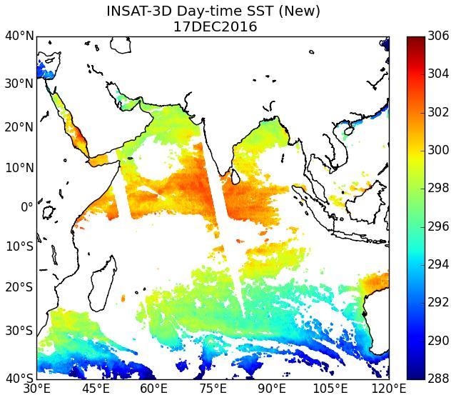


11 Operational Modified Comparison of INSAT-3D Day-time SST with MODIS for 17 December, 2016


12 Operational Modified Comparison of INSAT-3DR Day-time SST with MODIS for 17 December, 2016

13 Validation with in-situ SST measurements Operational INSAT-3D INSAT-3D Modified INSAT-3D INSAT-3D
14 Modified Operational Comparison of INSAT-3D SST with MODIS for December, 2016 Day-time Night-time Operational Modified Algorithm Statistics Daytime Nighttime Bias (K) RMSD (K) STD (K) Bias (K) RMSD (K) STD (K) Day-time Night-time
15 Modified Operational Comparison of INSAT-3DR SST with MODIS for December, 2016 Day-time Night-time Operational Modified Algorithm Statistics Daytime Nighttime Bias (K) RMSD (K) STD (K) Bias (K) RMSD (K) STD (K) Day-time Night-time
16 Conclusions SST products from INSAT-3D/3DR evaluated w.r.t. MODIS-SST shows that there are zenith angle dependent biases. Zenith angle dependent RT model bias correction procedure developed using ECMWF analysis and INSAT-3D/3DR matchup data. The modified algorithm shows an improvement over the operational algorithm for INSAT-3D/3DR observations. The zenith angle dependency in observed TIR-1/2 brightness temperatures need to be studied further. Further improvements will be attempted using LBL-RT model and improved cloud detection algorithm
17
RETRIEVAL AND APPLICATIONS OF ATMOSPHERIC MOTION VECTORS USING INSAT-3D/3DR DATA : ISRO STATUS
 RETRIEVAL AND APPLICATIONS OF ATMOSPHERIC MOTION VECTORS USING INSAT-3D/3DR DATA : ISRO STATUS Sanjib K Deb, D K Sankhala, C M Kishtawal Atmospheric and Oceanic Sciences Group Space Applications Centre
ISRO Report on the Status of Current and future satellites. Presented to CGMS-44 WP-01 Plenary Session
 ISRO Report on the Status of Current and future satellites Presented to CGMS-44 WP-01 Plenary Session CGMS-44-ISRO 05-10 June 2016 Indian Satellite System for weather parameters Satellite Oceansat-1/ MSMR
Status of Indian Satellite Meteorological Programme
 Status of Indian Satellite Meteorological Programme Pradeep K Thapliyal Space Applications Centre (SAC) Indian Space research Organisation (ISRO) Ahmedabad (INDIA) Email: pkthapliyal@sac.isro.gov.in International
Latest status and developments at IMD since CGMS-45
 Latest status and developments at IMD since CGMS-45 CGMS-46, Plenary session, agenda item IMD-ISRO-WP-01 Presenter: S K Peshin Report Prepared By: S K Peshin, Virendra Singh, A.K.Mitra Overview - Planning
VALIDATION OF INSAT-3D DERIVED RAINFALL. (Submitted by Suman Goyal, IMD) Summary and Purpose of Document
 Summary and Purpose of Document") WORLD METEOROLOGICAL ORGANIZATION COMMISSION FOR BASIC SYSTEMS OPEN PROGRAMME AREA GROUP ON INTEGRATED OBSERVING SYSTEMS INTER-PROGRAMME EXPERT TEAM ON SATELLITE UTILIZATION AND PRODUCTS SECOND SESSION
WORLD METEOROLOGICAL ORGANIZATION COMMISSION FOR BASIC SYSTEMS OPEN PROGRAMME AREA GROUP ON INTEGRATED OBSERVING SYSTEMS INTER-PROGRAMME EXPERT TEAM ON SATELLITE UTILIZATION AND PRODUCTS SECOND SESSION
Update on SCOPE-Nowcasting Pilot Project Real Time Ocean Products Suman Goyal Scientist-E
 Update on SCOPE-Nowcasting Pilot Project Real Time Ocean Products Suman Goyal Scientist-E 19-22 Nov 2013 SCOPE-Nowcasting-1 Agenda Item 5 Pilot Projects Overview Users /Clients User requirements Product
Earth Observation Satellite Program updates
 Earth Observation Satellite Program updates Presentation to ETSAT-7 meeting April 17-19, 2012, Geneva Prepared by: Indian Space Research Organisation Presented by Kashyap N. Mankad Space Applications Centre
Indian Earth Observation Programme
 Indian Earth Observation Programme Dr. Jai Singh Parihar Dy. Director Remote Sensing Applications Area (RESA) Space Applications Centre (ISRO) Ahmedabad 380 015 India jsparihar@sac.isro.gov.in Presentation
Report on the Status of Current and future satellites by ISRO. Presented to CGMS-46 Plenary, agenda item D.7
 Report on the Status of Current and future satellites by ISRO Presented to CGMS-46 Plenary, agenda item D.7 Current Satellites LAND & WATER HIGH RESOLUTION OCEAN WEATHER; CLIMATE RESOURCESAT-2 LISS-3,
Atmospheric Motion Vectors from Kalpana-1: An ISRO status
 Atmospheric Motion Vectors from Kalpana-1: An ISRO status Sanjib Kr. Deb, Inderpreet Kaur, C. M. Kishtawal and P. K. Pal Atmospheric and Oceanic Sciences Group Space Applications Centre Indian Space Research
Indian National (Weather) SATellites for Agrometeorological Applications
 SATellites for Agrometeorological Applications") Indian National (Weather) SATellites for Agrometeorological Applications Bimal K. Bhattacharya Agriculture-Terrestrial Biosphere- Hydrology Group Space Applications Centre (ISRO) Ahmedabad 380015, India
Indian National (Weather) SATellites for Agrometeorological Applications Bimal K. Bhattacharya Agriculture-Terrestrial Biosphere- Hydrology Group Space Applications Centre (ISRO) Ahmedabad 380015, India
Jun Park National Meteorological Satellite Center Korea Meteorological Administration
 KMA Implementation Plan for Satellite Climate products Jun Park National Meteorological Satellite Center Korea Meteorological Administration jun.park@kma.go.kr Outline 1. Introduction : Current & Future
OCEAN COLOUR MONITOR ON-BOARD OCEANSAT-2
 OCEAN COLOUR MONITOR ON-BOARD OCEANSAT-2 Rangnath R Navalgund Space Applications Centre Indian Space Research Organisation Ahmedabad-380015, INDIA OCEANSAT-2 2 MISSION OCEANSAT-2 2 is a global mission
Preparation for FY-4A. (Submitted by Xiang Fang, CMA)
") WORLD METEOROLOGICAL ORGANIZATION COMMISSION FOR BASIC SYSTEMS OPEN PROGRAMME AREA GROUP ON INTEGRATED OBSERVING SYSTEMS EXPERT TEAM ON SATELLITE UTILIZATION AND PRODUCTS ET-SUP-8/Doc. 10.3 (2.IV.2014)
WORLD METEOROLOGICAL ORGANIZATION COMMISSION FOR BASIC SYSTEMS OPEN PROGRAMME AREA GROUP ON INTEGRATED OBSERVING SYSTEMS EXPERT TEAM ON SATELLITE UTILIZATION AND PRODUCTS ET-SUP-8/Doc. 10.3 (2.IV.2014)
INSAT-3D PRODUCTS FOR THE MONSOON MONITORING and APPLICATIONS
 INSAT-3D PRODUCTS FOR THE MONSOON MONITORING and APPLICATIONS Ashim Kumar Mitra 23-24 February 2016 National Satellite Meteorological Center, India Meteorological Department, New Delhi-110003 Current Indian
APPLICATIONS WITH METEOROLOGICAL SATELLITES. W. Paul Menzel. Office of Research and Applications NOAA/NESDIS University of Wisconsin Madison, WI
 APPLICATIONS WITH METEOROLOGICAL SATELLITES by W. Paul Menzel Office of Research and Applications NOAA/NESDIS University of Wisconsin Madison, WI July 2004 Unpublished Work Copyright Pending TABLE OF CONTENTS
Megha-Tropiques Presentation by Indian Delegation at the 55th Session of UNCOPUOS Vienna 12 June 2012
 Megha-Tropiques Presentation by Indian Delegation at the 55 th Session of UNCOPUOS Vienna 12 June 2012 Megha-Tropiques Mission Indo-French Joint Satellite for studying tropical atmosphere Megha in Sanskrit
MSG system over view
 MSG system over view 1 Introduction METEOSAT SECOND GENERATION Overview 2 MSG Missions and Services 3 The SEVIRI Instrument 4 The MSG Ground Segment 5 SAF Network 6 Conclusions METEOSAT SECOND GENERATION
GOFC-GOLD Regional Networks. Krishna Vadrevu NASA MSFC
 GOFC-GOLD Regional Networks Krishna Vadrevu NASA MSFC GOFC-GOLD Implementation Teams (IT) Land Cover Characteristics and Change Fire Monitoring and Mapping Working Groups (WG) Working Group on Reducing
Operational Uses of Bands on the GOES-R Advanced Baseline Imager (ABI) Presented by: Kaba Bah
 Presented by: Kaba Bah") Operational Uses of Bands on the GOES-R Advanced Baseline Imager (ABI) Presented by: Kaba Bah Topics: Introduction to GOES-R & ABI ABI individual bands Use of band differences ABI derived products Conclusions
Operational Uses of Bands on the GOES-R Advanced Baseline Imager (ABI) Presented by: Kaba Bah Topics: Introduction to GOES-R & ABI ABI individual bands Use of band differences ABI derived products Conclusions
Status report on the current and future satellite systems by CMA. Presented to CGMS46-CMA-WP-01, Plenary session, agenda item D.1
 Status report on the current and future satellite systems by CMA Presented to CGMS46-CMA-WP-01, Plenary session, agenda item D.1 Overview - Planning of CMA satellite systems FengYun Meteorological Satellites
Lecture 19: Operational Remote Sensing in Visible, IR, and Microwave Channels
 MET 4994 Remote Sensing: Radar and Satellite Meteorology MET 5994 Remote Sensing in Meteorology Lecture 19: Operational Remote Sensing in Visible, IR, and Microwave Channels Before you use data from any
Simulation and Validation of INSAT-3D sounder data at NCMRWF
 Simulation and Validation of INSAT-3D sounder data at NCMRWF S. Indira Rani and V. S. Prasad National Centre for Medium Range Weather Forecasting (NCMRWF) Earth System Science Organization (ESSO) Ministry
Introduction of the Hyperspectral Environmental Suite (HES) on GOES-R and beyond
 on GOES-R and beyond") Introduction of the Hyperspectral Environmental Suite (HES) on GOES-R and beyond Timothy J. Schmit SaTellite Applications and Research (STAR) Advanced Satellite Products Team (ASPT) Presented by Jun Li
Introduction of the Hyperspectral Environmental Suite (HES) on GOES-R and beyond Timothy J. Schmit SaTellite Applications and Research (STAR) Advanced Satellite Products Team (ASPT) Presented by Jun Li
Lecture 4b: Meteorological Satellites and Instruments. Acknowledgement: Dr. S. Kidder at Colorado State Univ.
 Lecture 4b: Meteorological Satellites and Instruments Acknowledgement: Dr. S. Kidder at Colorado State Univ. US Geostationary satellites - GOES (Geostationary Operational Environmental Satellites) US
Recent Indian Space Missions : Update Feb 2014
 Recent Indian Space Missions : Update Feb 2014 51 S&T Committee of UNCOPUOS 10-21 Feb, 2014, Vienna V. K. DADHWAL, ISRO, INDIA Mission Summary: 2013/2 2014/2 MISSION THEME (prev. Missions) REALIZED (Under
REVISION OF THE STATEMENT OF GUIDANCE FOR GLOBAL NUMERICAL WEATHER PREDICTION. (Submitted by Dr. J. Eyre)
") WORLD METEOROLOGICAL ORGANIZATION Distr.: RESTRICTED CBS/OPAG-IOS (ODRRGOS-5)/Doc.5, Add.5 (11.VI.2002) COMMISSION FOR BASIC SYSTEMS OPEN PROGRAMME AREA GROUP ON INTEGRATED OBSERVING SYSTEMS ITEM: 4 EXPERT
WORLD METEOROLOGICAL ORGANIZATION Distr.: RESTRICTED CBS/OPAG-IOS (ODRRGOS-5)/Doc.5, Add.5 (11.VI.2002) COMMISSION FOR BASIC SYSTEMS OPEN PROGRAMME AREA GROUP ON INTEGRATED OBSERVING SYSTEMS ITEM: 4 EXPERT
Polar winds from highly elliptical orbiting satellites: a new perspective
 Polar winds from highly elliptical orbiting satellites: a new perspective 10 th International Winds Workshop Tokyo, Japan, Feb -6, 010 L. Garand 1, N. Wagneur 1, R. Sarrazin 1, D. Santek, J. Key 1 Environment
McIDAS support of Suomi-NPP /JPSS and GOES-R L2
 McIDAS support of Suomi-NPP /JPSS and GOES-R L2 William Straka III 1 Tommy Jasmin 1, Bob Carp 1 1 Cooperative Institute for Meteorological Satellite Studies, Space Science and Engineering Center, University
Cloud detection for IASI/AIRS using imagery
 Cloud detection for IASI/AIRS using imagery Lydie Lavanant* Mohamed Dahoui** Florence Rabier***, Thomas Auligné*** * Météo-France/DP/CMS/R&D ** Moroccan Meterological Service. NWPSAF Visiting Scientist
Arctic Weather Every 10 Minutes: Design & Operation of ABI for PCW
 Arctic Weather Every 10 Minutes: Design and Operation of ABI for PCW Dr. Paul C. Griffith and Sue Wirth 31st Space Symposium, Technical Track, Colorado Springs, Colorado This document is not subject to
The Megha-Tropiques Mission
 The Megha-Tropiques Mission May 8,, 2010 0600Z courtesy www.satmos.meteo.fr Rémy Roca and the French MT science team Overview Indo-french mission realized by The Indian Space Research Organisation et the
Summary Remote Sensing Seminar
 Summary Remote Sensing Seminar Lectures at CREST Paul Menzel NOAA/NESDIS/ORA March 2006 Satellite remote sensing of the Earth-atmosphere Observations depend on telescope characteristics (resolving power,
Future GOES (XGOHI, GOES-13/O/P, GOES-R+)
") Future GOES (XGOHI, GOES-13/O/P, GOES-R+) Timothy J. Schmit NOAA/NESDIS/Satellite Applications and Research Advanced Satellite Products Branch (ASPB) Madison, WI And many others MUG Meeting October 16,
Future GOES (XGOHI, GOES-13/O/P, GOES-R+) Timothy J. Schmit NOAA/NESDIS/Satellite Applications and Research Advanced Satellite Products Branch (ASPB) Madison, WI And many others MUG Meeting October 16,
Data Short description Parameters to be used for analysis SYNOP. Surface observations by ships, oil rigs and moored buoys
 3.2 Observational Data 3.2.1 Data used in the analysis Data Short description Parameters to be used for analysis SYNOP Surface observations at fixed stations over land P,, T, Rh SHIP BUOY TEMP PILOT Aircraft
Satellite Observations of Greenhouse Gases
 Satellite Observations of Greenhouse Gases Richard Engelen European Centre for Medium-Range Weather Forecasts Outline Introduction Data assimilation vs. retrievals 4D-Var data assimilation Observations
Outgoing long wave radiation (OLR) a proxy of convection
 a proxy of convection") Outgoing long wave radiation (OLR) a proxy of convection Vijay Garg M.M.College, Modinagar, Ghaziabad Abstract: Outgoing long wave radiation (OLR) is a proxy indicator of convection. It is measured through
Outgoing long wave radiation (OLR) a proxy of convection Vijay Garg M.M.College, Modinagar, Ghaziabad Abstract: Outgoing long wave radiation (OLR) is a proxy indicator of convection. It is measured through
Assimilation of Direct Satellite Radiance Data at NCMRWF. V.S. Prasad NCMRWF
 Assimilation of Direct Satellite Radiance Data at NCMRWF V.S. Prasad NCMRWF Building of data assimilation system Observing system Data handling system Forecast model Computational resources understanding
K. H. Rao Consultant and Retired Scientist G and Group Director Ocean Sciences Group NRSC/ ISRO, Balanagar, Hyderabad
 Remote Sensing Coastal and GIS K. H. Rao Consultant and Retired Scientist G and Group Director Ocean Sciences Group NRSC/ ISRO, Balanagar, Hyderabad INTRODUCTION AVAILABILITY OF OPERATIONAL RESOURCES MONITORING
Sea Ice Advisories for Indian Research & Supply Vessels
 Sea Ice Advisories for Indian Research & Supply Vessels D. Ram Rajak, R. K. Kamaljit Singh, Jayaprasad P., Sandip R. Oza, M. Javed Beg* Space Applications Centre, ISRO, Ahmedabad, India. *National Centre
Joel Susskind John M. Blaisdell Lena Iredell
 Improved methodology for surface and atmospheric soundings, error estimates, and quality control procedures: the atmospheric infrared sounder science team version-6 retrieval algorithm Joel Susskind John
Infrared continental surface emissivity spectra and skin temperature retrieved from IASI observation
 Infrared continental surface emissivity spectra and skin temperature retrieved from IASI observation Capelle V., Chédin A., Péquignot E., N. A Scott Schlüssel P., Newman S. IASI Conference 2013 Introduction
GIFTS SOUNDING RETRIEVAL ALGORITHM DEVELOPMENT
 P2.32 GIFTS SOUNDING RETRIEVAL ALGORITHM DEVELOPMENT Jun Li, Fengying Sun, Suzanne Seemann, Elisabeth Weisz, and Hung-Lung Huang Cooperative Institute for Meteorological Satellite Studies (CIMSS) University
Data assimilation of IASI radiances over land.
 Data assimilation of IASI radiances over land. PhD supervised by Nadia Fourrié, Florence Rabier and Vincent Guidard. 18th International TOVS Study Conference 21-27 March 2012, Toulouse Contents 1. IASI
Land Surface Temperature Measurements From the Split Window Channels of the NOAA 7 Advanced Very High Resolution Radiometer John C.
 Land Surface Temperature Measurements From the Split Window Channels of the NOAA 7 Advanced Very High Resolution Radiometer John C. Price Published in the Journal of Geophysical Research, 1984 Presented
CLOUD CLASSIFICATION AND CLOUD PROPERTY RETRIEVAL FROM MODIS AND AIRS
 6.4 CLOUD CLASSIFICATION AND CLOUD PROPERTY RETRIEVAL FROM MODIS AND AIRS Jun Li *, W. Paul Menzel @, Timothy, J. Schmit @, Zhenglong Li *, and James Gurka # *Cooperative Institute for Meteorological Satellite
Humidity profile retrieval from SAPHIR on-board the Megha-Tropiques
 Humidity profile retrieval from SAPHIR on-board the Megha-Tropiques A. K. Mathur, R. K. Gangwar, B. S. Gohil*, Sanjib K. Deb, Prashant Kumar, Munn V. Shukla, B. Simon and P. K. Pal Atmosphere and Oceanic
SAFNWC/MSG SEVIRI CLOUD PRODUCTS
 SAFNWC/MSG SEVIRI CLOUD PRODUCTS M. Derrien and H. Le Gléau Météo-France / DP / Centre de Météorologie Spatiale BP 147 22302 Lannion. France ABSTRACT Within the SAF in support to Nowcasting and Very Short
Lectures 7 and 8: 14, 16 Oct Sea Surface Temperature
 Lectures 7 and 8: 14, 16 Oct 2008 Sea Surface Temperature References: Martin, S., 2004, An Introduction to Ocean Remote Sensing, Cambridge University Press, 454 pp. Chapter 7. Robinson, I. S., 2004, Measuring
Evaluation of Regressive Analysis Based Sea Surface Temperature Estimation Accuracy with NCEP/GDAS Data
 Evaluation of Regressive Analysis Based Sea Surface Temperature Estimation Accuracy with NCEP/GDAS Data Kohei Arai 1 Graduate School of Science and Engineering Saga University Saga City, Japan Abstract
CORRELATION BETWEEN ATMOSPHERIC COMPOSITION AND VERTICAL STRUCTURE AS MEASURED BY THREE GENERATIONS OF HYPERSPECTRAL SOUNDERS IN SPACE
 CORRELATION BETWEEN ATMOSPHERIC COMPOSITION AND VERTICAL STRUCTURE AS MEASURED BY THREE GENERATIONS OF HYPERSPECTRAL SOUNDERS IN SPACE Nadia Smith 1, Elisabeth Weisz 1, and Allen Huang 1 1 Space Science
Remote Sensing of Precipitation
 Lecture Notes Prepared by Prof. J. Francis Spring 2003 Remote Sensing of Precipitation Primary reference: Chapter 9 of KVH I. Motivation -- why do we need to measure precipitation with remote sensing instruments?
A Time Lag Model to Estimate Rainfall Rate Based on GOES Data
 A Time Lag Model to Estimate Rainfall Rate Based on GOES Data Nazario D. Ramirez, Robert J. Kuligowski, and Joan M. Castro Octava Reunión Nacional de Percepción Remota y Sistemas Geográficos de Información
Feature-tracked 3D Winds from Satellite Sounders: Derivation and Impact in Global Models
 Feature-tracked 3D Winds from Satellite Sounders: Derivation and Impact in Global Models David Santek, Anne-Sophie Daloz 1, Samantha Tushaus 1, Marek Rogal 1, Will McCarty 2 1 Space Science and Engineering
METEOSAT THIRD GENERATION
 METEOSAT THIRD GENERATION FACTS AND FIGURES MONITORING WEATHER AND CLIMATE FROM SPACE A HIGHLY INNOVATIVE GEOSTATIONARY SATELLITE SYSTEM FOR EUROPE AND AFRICA The Meteosat Third Generation (MTG) system
F O U N D A T I O N A L C O U R S E
 F O U N D A T I O N A L C O U R S E December 6, 2018 Satellite Foundational Course for JPSS (SatFC-J) F O U N D A T I O N A L C O U R S E Introduction to Microwave Remote Sensing (with a focus on passive
AIRS Level 1b. Tom Pagano AIRS Project Project Manager. Hartmut Aumann AIRS Project Scientist
 AIRS Level 1b Tom Pagano AIRS Project Project Manager Hartmut Aumann AIRS Project Scientist Jet Propulsion Laboratory California Institute of Technology and Ken Overoye AIRS Calibration System Engineer
Instrumentation planned for MetOp-SG
 Instrumentation planned for MetOp-SG Bill Bell Satellite Radiance Assimilation Group Met Office Crown copyright Met Office Outline Background - the MetOp-SG programme The MetOp-SG instruments Summary Acknowledgements:
THE FEASIBILITY OF EXTRACTING LOWLEVEL WIND BY TRACING LOW LEVEL MOISTURE OBSERVED IN IR IMAGERY OVER CLOUD FREE OCEAN AREA IN THE TROPICS
 THE FEASIBILITY OF EXTRACTING LOWLEVEL WIND BY TRACING LOW LEVEL MOISTURE OBSERVED IN IR IMAGERY OVER CLOUD FREE OCEAN AREA IN THE TROPICS Toshiro Ihoue and Tetsuo Nakazawa Meteorological Research Institute
Retrieval Algorithm Using Super channels
 Retrieval Algorithm Using Super channels Xu Liu NASA Langley Research Center, Hampton VA 23662 D. K. Zhou, A. M. Larar (NASA LaRC) W. L. Smith (HU and UW) P. Schluessel (EUMETSAT) Hank Revercomb (UW) Jonathan
Bias correction of satellite data at Météo-France
 Bias correction of satellite data at Météo-France É. Gérard, F. Rabier, D. Lacroix, P. Moll, T. Montmerle, P. Poli CNRM/GMAP 42 Avenue Coriolis, 31057 Toulouse, France 1. Introduction Bias correction at
The Copernicus Sentinel-5 Mission: Daily Global Data for Air Quality, Climate and Stratospheric Ozone Applications
 SENTINEL-5 The Copernicus Sentinel-5 Mission: Daily Global Data for Air Quality, Climate and Stratospheric Ozone Applications Yasjka Meijer RHEA for ESA, Noordwijk, NL 15/04/2016 Co-Authors: Jörg Langen,
A new perspective on aerosol direct radiative effects in South Atlantic and Southern Africa
 A new perspective on aerosol direct radiative effects in South Atlantic and Southern Africa Ian Chang and Sundar A. Christopher Department of Atmospheric Science University of Alabama in Huntsville, U.S.A.
11 days (00, 12 UTC) 132 hours (06, 18 UTC) One unperturbed control forecast and 26 perturbed ensemble members. --
 132 hours (06, 18 UTC) One unperturbed control forecast and 26 perturbed ensemble members. --") APPENDIX 2.2.6. CHARACTERISTICS OF GLOBAL EPS 1. Ensemble system Ensemble (version) Global EPS (GEPS1701) Date of implementation 19 January 2017 2. EPS configuration Model (version) Global Spectral Model
APPENDIX 2.2.6. CHARACTERISTICS OF GLOBAL EPS 1. Ensemble system Ensemble (version) Global EPS (GEPS1701) Date of implementation 19 January 2017 2. EPS configuration Model (version) Global Spectral Model
Study of the Influence of Thin Cirrus Clouds on Satellite Radiances Using Raman Lidar and GOES Data
 Study of the Influence of Thin Cirrus Clouds on Satellite Radiances Using Raman Lidar and GOES Data D. N. Whiteman, D. O C. Starr, and G. Schwemmer National Aeronautics and Space Administration Goddard
Satellite data assimilation for Numerical Weather Prediction II
 Satellite data assimilation for Numerical Weather Prediction II Niels Bormann European Centre for Medium-range Weather Forecasts (ECMWF) (with contributions from Tony McNally, Jean-Noël Thépaut, Slide
Ranganath R. Navalgund AND Raghavendra P. Singh
 REVIEWS The evolution of the earth observation system in India Ranganath R. Navalgund AND Raghavendra P. Singh Abstract The Indian Earth Observations Programme has been applications- driven and national
HIGH SPATIAL AND TEMPORAL RESOLUTION ATMOSPHERIC MOTION VECTORS GENERATION, ERROR CHARACTERIZATION AND ASSIMILATION
 HIGH SPATIAL AND TEMPORAL RESOLUTION ATMOSPHERIC MOTION VECTORS GENERATION, ERROR CHARACTERIZATION AND ASSIMILATION John Le Marshall Director, JCSDA 2004-2007 CAWCR 2007-2010 John Le Marshall 1,2, Rolf
Cross-track Infrared Sounder (CrIS) Instrument In-flight Performance CALCON 2012 Vladimir Zavyalov, Gail Bingham, Mark Esplin, Mark Greenman, Deron
 Instrument In-flight Performance CALCON 2012 Vladimir Zavyalov, Gail Bingham, Mark Esplin, Mark Greenman, Deron") Cross-track Infrared Sounder (CrIS) Instrument In-flight Performance CALCON 2012 Vladimir Zavyalov, Gail Bingham, Mark Esplin, Mark Greenman, Deron Scott, Brandon Graham, Charles Major, and Lee Phillips
Cross-track Infrared Sounder (CrIS) Instrument In-flight Performance CALCON 2012 Vladimir Zavyalov, Gail Bingham, Mark Esplin, Mark Greenman, Deron Scott, Brandon Graham, Charles Major, and Lee Phillips
Applications of the SEVIRI window channels in the infrared.
 Applications of the SEVIRI window channels in the infrared jose.prieto@eumetsat.int SEVIRI CHANNELS Properties Channel Cloud Gases Application HRV 0.7 Absorption Scattering
School on Modelling Tools and Capacity Building in Climate and Public Health April Remote Sensing
 2453-5 School on Modelling Tools and Capacity Building in Climate and Public Health 15-26 April 2013 Remote Sensing CECCATO Pietro International Research Institute for Climate and Society, IRI The Earth
ATMOS 5140 Lecture 1 Chapter 1
 ATMOS 5140 Lecture 1 Chapter 1 Atmospheric Radiation Relevance for Weather and Climate Solar Radiation Thermal Infrared Radiation Global Heat Engine Components of the Earth s Energy Budget Relevance for
GMES: calibration of remote sensing datasets
 GMES: calibration of remote sensing datasets Jeremy Morley Dept. Geomatic Engineering jmorley@ge.ucl.ac.uk December 2006 Outline Role of calibration & validation in remote sensing Types of calibration
P3.24 EVALUATION OF MODERATE-RESOLUTION IMAGING SPECTRORADIOMETER (MODIS) SHORTWAVE INFRARED BANDS FOR OPTIMUM NIGHTTIME FOG DETECTION
 SHORTWAVE INFRARED BANDS FOR OPTIMUM NIGHTTIME FOG DETECTION") P3.24 EVALUATION OF MODERATE-RESOLUTION IMAGING SPECTRORADIOMETER (MODIS) SHORTWAVE INFRARED BANDS FOR OPTIMUM NIGHTTIME FOG DETECTION 1. INTRODUCTION Gary P. Ellrod * NOAA/NESDIS/ORA Camp Springs, MD
P3.24 EVALUATION OF MODERATE-RESOLUTION IMAGING SPECTRORADIOMETER (MODIS) SHORTWAVE INFRARED BANDS FOR OPTIMUM NIGHTTIME FOG DETECTION 1. INTRODUCTION Gary P. Ellrod * NOAA/NESDIS/ORA Camp Springs, MD
The use and impacts of sea surface temperature from passive microwave measurements
 The use and impacts of sea surface temperature from passive microwave measurements Anne O Carroll 6/12/2017 ECMWF workshop on using low frequency passive microwave measurements in research and operational
Lectures 7 and 8: 13, 18 Feb Sea Surface Temperature
 Lectures 7 and 8: 13, 18 Feb 2008 Sea Surface Temperature References: Martin, S., 2004, An Introduction to Ocean Remote Sensing, Cambridge University Press, 454 pp. Chapter 7. Robinson, I. S., 2004, Measuring
6 th ET SAT meeting, April 12 15, Geneva, Switzerland Satellite Programme of KMA
 6 th ET SAT meeting, April 12 15, Geneva, Switzerland Satellite Programme of KMA Korea Meteorological Administration National Meteorological Satellite Center Status of COMS COMS Heritage COM Design & Review
ESTIMATION OF ATMOSPHERIC COLUMN AND NEAR SURFACE WATER VAPOR CONTENT USING THE RADIANCE VALUES OF MODIS
 ESTIMATION OF ATMOSPHERIC COLUMN AND NEAR SURFACE WATER VAPOR CONTENT USIN THE RADIANCE VALUES OF MODIS M. Moradizadeh a,, M. Momeni b, M.R. Saradjian a a Remote Sensing Division, Centre of Excellence
Assimilation of Cloud-Affected Infrared Radiances at Environment-Canada
 Assimilation of Cloud-Affected Infrared Radiances at Environment-Canada ECMWF-JCSDA Workshop on Assimilating Satellite Observations of Clouds and Precipitation into NWP models ECMWF, Reading (UK) Sylvain
Recent Data Assimilation Activities at Environment Canada
 Recent Data Assimilation Activities at Environment Canada Major upgrade to global and regional deterministic prediction systems (now in parallel run) Sea ice data assimilation Mark Buehner Data Assimilation
Atmospheric Soundings of Temperature, Moisture and Ozone from AIRS
 Atmospheric Soundings of Temperature, Moisture and Ozone from AIRS M.D. Goldberg, W. Wolf, L. Zhou, M. Divakarla,, C.D. Barnet, L. McMillin, NOAA/NESDIS/ORA Oct 31, 2003 Presented at ITSC-13 Risk Reduction
Topics: Visible & Infrared Measurement Principal Radiation and the Planck Function Infrared Radiative Transfer Equation
 Review of Remote Sensing Fundamentals Allen Huang Cooperative Institute for Meteorological Satellite Studies Space Science & Engineering Center University of Wisconsin-Madison, USA Topics: Visible & Infrared
Chapter 4 Nadir looking UV measurement. Part-I: Theory and algorithm
 Chapter 4 Nadir looking UV measurement. Part-I: Theory and algorithm -Aerosol and tropospheric ozone retrieval method using continuous UV spectra- Atmospheric composition measurements from satellites are
Study of the cloud cover variability over Indian region using Geo- Stationary Satellitedata
 International Archive of Applied Sciences and Technology Int. Arch. App. Sci. Technol; Vol 9 [3] September 2018 : 29-34 2018 Society of Education, India [ISO9001: 2008 Certified Organization] www.soeagra.com/iaast.html
Determination of atmospheric temperature, far- infrared hyperspectral measurements
 Determination of atmospheric temperature, water vapor, and heating rates from mid- and far- infrared hyperspectral measurements AGU Fall Meeting, Wednesday, December 12, 2007 GC34A 02 D.R. Feldman (Caltech);
Sensitivity Analysis on Sea Surface Temperature Estimation Methods with Thermal Infrared Radiometer Data through Simulations
 Sensitivity Analysis on Sea Surface Temperature Estimation Methods with Thermal Infrared Radiometer Data through Simulations Kohei Arai 1 Graduate School of Science and Engineering Saga University Saga
Lecture 3. Background materials. Planetary radiative equilibrium TOA outgoing radiation = TOA incoming radiation Figure 3.1
 Lecture 3. Changes in planetary albedo. Is there a clear signal caused by aerosols and clouds? Outline: 1. Background materials. 2. Papers for class discussion: Palle et al., Changes in Earth s reflectance
Towards a better use of AMSU over land at ECMWF
 Towards a better use of AMSU over land at ECMWF Blazej Krzeminski 1), Niels Bormann 1), Fatima Karbou 2) and Peter Bauer 1) 1) European Centre for Medium-range Weather Forecasts (ECMWF), Shinfield Park,
A 2016 CEOS Chair Initiative. Non-meteorological Applications for Next Generation Geostationary Satellites
 A 2016 CEOS Chair Initiative Committee on Earth Observation Satellites Non-meteorological Applications for Next Generation Geostationary Satellites Co-chaired by EUMETSAT (Holmlund), CSIRO (Schroeder),
ECNU WORKSHOP LAB ONE 2011/05/25)
") ECNU WORKSHOP LAB ONE (Liam.Gumley@ssec.wisc.edu 2011/05/25) The objective of this laboratory exercise is to become familiar with the characteristics of MODIS Level 1B 1000 meter resolution data. After
ECNU WORKSHOP LAB ONE (Liam.Gumley@ssec.wisc.edu 2011/05/25) The objective of this laboratory exercise is to become familiar with the characteristics of MODIS Level 1B 1000 meter resolution data. After
Rosemary Munro*, Graeme Kelly, Michael Rohn* and Roger Saunders
 ASSIMILATION OF METEOSAT RADIANCE DATA WITHIN THE 4DVAR SYSTEM AT ECMWF Rosemary Munro*, Graeme Kelly, Michael Rohn* and Roger Saunders European Centre for Medium Range Weather Forecasts Shinfield Park,
Remote Sensing I: Basics
 Remote Sensing I: Basics Kelly M. Brunt Earth System Science Interdisciplinary Center, University of Maryland Cryospheric Science Laboratory, Goddard Space Flight Center kelly.m.brunt@nasa.gov (Based on
ITSC-16 Conference. May 2008 Using AVHRR radiances analysis for retrieving atmospheric profiles with IASI in cloudy conditions
 ITSC-16 Conference. May 2008 Using AVHRR radiances analysis for retrieving atmospheric profiles with IASI in cloudy conditions Lydie Lavanant MF/DP/CMS/R&D Experimental production at CMS of near-real real
OSI SAF SST Products and Services
 OSI SAF SST Products and Services Pierre Le Borgne Météo-France/DP/CMS (With G. Legendre, A. Marsouin, S. Péré, S. Philippe, H. Roquet) 2 Outline Satellite IR radiometric measurements From Brightness Temperatures
Uncertainty of Atmospheric Temperature Trends Derived from Satellite Microwave Sounding Data
 Uncertainty of Atmospheric Temperature Trends Derived from Satellite Microwave Sounding Data Fuzhong Weng NOAA Center for Satellite Applications and Research and Xiaolei Zou University of University November
IRFS-2 instrument onboard Meteor-M N2 satellite: measurements analysis
 IRFS-2 instrument onboard Meteor-M N2 satellite: measurements analysis Polyakov A.V., Virolainen Ya.A., Timofeyev Yu.M. SPbSU, Saint-Petersburg, Russia Uspensky A.B., A.N. Rublev, SRC Planeta, Moscow,
Data Format and Visualization Agenda
 Data Format and Visualization Agenda- 7.2.2 ET-SUP-8 (14.04.2014) Suman Goyal, Satellite Meteorology Division, India Meteorological Department, Suman_goyal61@yahoo.co.in Visualization Methods The satellite
CGMS Baseline. Sustained contributions to the Global Observing System. Endorsed by CGMS-46 in Bengaluru, June 2018
 CGMS Baseline Sustained contributions to the Global Observing System Best Practices for Achieving User Readiness for New Meteorological Satellites Endorsed by CGMS-46 in Bengaluru, June 2018 CGMS/DOC/18/1028862,
The current status of FY-3D. (Submitted by Xiang Fang, CMA) Summary and Purpose of Document
 Summary and Purpose of Document") WORLD METEOROLOGICAL ORGANIZATION COMMISSION FOR BASIC SYSTEMS OPEN PROGRAMME AREA GROUP ON INTEGRATED OBSERVING SYSTEMS INTER-PROGRAMME EXPERT TEAM ON SATELLITE UTILIZATION AND PRODUCTS FOURTH SESSION
WORLD METEOROLOGICAL ORGANIZATION COMMISSION FOR BASIC SYSTEMS OPEN PROGRAMME AREA GROUP ON INTEGRATED OBSERVING SYSTEMS INTER-PROGRAMME EXPERT TEAM ON SATELLITE UTILIZATION AND PRODUCTS FOURTH SESSION
Generating a Climate data record for SST from Passive Microwave observations
 ESA Climate Change Initiative Phase-II Sea Surface Temperature (SST) www.esa-sst-cci.org Generating a Climate data record for SST from Passive Microwave observations Jacob L. Høyer, Jörg Steinwagner, Pia