Follow-up to WMO 2012 Survey on the Use of Satellite Data: Feedback by RA I Members
|
|
|
- Heather Thornton
- 5 years ago
- Views:
Transcription
 WMO; Observation and Information System Department (OBS)")
1 WMO Follow-up to WMO 2012 Survey on the Use of Satellite Data: Feedback by RA I Members Gillie Cheelo-Intern WMO Space Programme World Meteorological Organization (WMO) WMO; Observation and Information System Department (OBS)
2 Outline Introduction Challenges and findings from four African countries 10th African User Forum recommendations Feedback Summary on challenges and response 2
3 Introduction A key objective of the WMO Space Programme is to: Promote availability and utilization of satellite data and products for weather, climate, water and related applications to its Members In light of this, WMO conducted a user survey in 2012: Results were presented at RAIDEG-4 PUB_SP-9-Survey-Report-2012.pdf 3
4 Challenges identified in 2012 WMO Survey RA I 80% 70% 60% 50% 40% Research and Academia NMHS and Other operational agency 30% 20% 10% 0% Knowledge of data Accessing data NRT Accessing data general Data processing Utility of data Analysis and interpretation Resources Do not face significant challenges
5 Follow-up This work is aimed at following up on the 2012 WMO Survey responses for four African countries in the areas of: 1. Access to satellite data and products 2. Application and use of satellite data 3. Training on satellite data utilization This is to better understand their responses and challenges NMHS contacted are: Kenya, Ethiopia, Mauritius and Cameroun 5
6 Country specific findings and challenges Kenya (Mr. Gitonga) WMO Challenges Knowledge of the available satellite data/products. Direct read-out (HRPT) station currently not working. Preparation for new generation satellites. Findings Confirm that HRPT Station is non-functional and both the tracking unit and the antenna are obsolete GIS implementation needed to provide local decentralized services GIS Remote Sensing proposal done but lack funding Training on quantitative rainfall estimates needed; Classroom based training favoured 6
7 Country specific findings and challenges Mauritius (Mr. Dhurmea Ram Kumar) WMO Challenges Mauritius is on the periphery for the FOV of MSG at 0 degree Preparation for new generation satellites Product (Utilization and Interpretation) Findings Using products from Meteosat 7 (IODC); INSAT- 3D data are not available; and relatively poor products from FY-2D Need more training on monitoring convective activity in a marine environment; this includes training on scatterometry, images interpretation (RGB products are critical), manipulating of raw data to derive products. EUMETSAT and COMET provide well tailored training materials Tried out SATURN website and found it to be good and more information need to be provided 7
8 Country specific findings and challenges Cameroun (Mr. BONGKIYUNG Emmanuel NYUYKI) WMO Challenges Knowledge of the available satellite data/products. Preparation for the new generation satellites. Use of software tools (processing, analysis, assimilation). Further training on image interpretation and data processing. Findings Further training on GIS for mapping of specific zones, utilization of marine products and models Training on quantitative rainfall estimate, damage estimate from convective systems and use of lightning data 8
9 Country specific findings and challenges Ethiopia (Mr. Kassa Fekadu) WMO Challenges knowledge of the available satellite data/products. equipment operation and maintenance use of software tools (processing, analysis, assimilation) Findings EUMETSAT conducted training courses through CoEs on availability of data and products Suggested that Meteo France International provide training on image analysis, equipment operation and maintenance (use of SYNERGIE) EUMETSAT has been working with sub Sahara African countries to address these challenges for years now 9
10 10th African User Forum recommendations Recommendation #3: Improving user awareness of satellite data and products Data providers take further steps to communicate the existing satellite products. Recommendation #9: user preparation for new satellite generations EUMETSAT takes into account the african user community in its planning to prepare users for the meteosat third generation and for the EPS second generation programmes 10
11 Addressing challenges Part of the objectives of the WMO 2012 Survey was to identify areas for improvement and remedial action Assistance is provided through: 1. WMO Online Resources (OSCAR, PAG, SATURN) 2. WMO-CGMS VLab, EUMETSAT and COMET training activities and resources in support of RA I 3. CGMS-42 recommendations and actions (re Indian Ocean Data Coverage) The next slides explain briefly the WMO online resources and how they are used to respond to the stated challenges 11
12 (1) Product Access Guide (PAG) Goal & Objectives Web-based WMO resource In support of the WMO Information System Developed to address insufficient user awareness of satellite products (WMO Survey, 2012) Facilitates access to quality controlled satellite data and products Developed to enhance visibility of satellite products and related information Providers of satellite data retain full ownership and responsibility for their products 12
13 (1) Product Access Guide (PAG) Implementation Links to stable URLs of satellite product collections, expert groups, training material Products must be sufficiently described to meet user demand for information (metadata criteria) Structured by geophysical domain, tags 13
14 (1) Product Access Guide (PAG) Acceptance into PAG is based on the following Metadata Criteria: Point of contact Product identifier Providing organization Data source Applicability domain Geographical region Resolution Update frequency Access information Quality indication / documentation With the aim to satisfy users` needs for documentation and to harmonized online product metadata used by providers 14
15 (1) Product Access Guide (PAG) PAG Link: 1. Hierarchical/Simple Search: select by clicking on the domain 2. Advanced Search: based on combination of tags:domain, theme, geographic regional, organization providing and type of content. 3. Highlighted themes: based on themes such as Tropical meteorology, water, health, disaster 15
16 (1) Product Access Guide (PAG) Current status Links to 86 product collections from several providers: Sounder Radiances, Inland Waters (Rivers, Lakes Floods), Soil Moisture, Clouds, Land Cover, Fire, Volcanic Ash, Aerosols, Dust, Lightning, Sea Level, Ocean Colour, Winds, Land Surface Temperature, Precipitation, Vegetation NDVI, Ocean Surface Winds, Ozone, Green House Gases and other trace gases, Ionosphere, Sea Surface Temperature, Ocean Surface Winds,.. This now includes links to relevant sub-sets of the EUMETSAT Product Navigator 23 links to sets of corresponding online training materials 14 links to international expert groups (e.g., on precipitation, winds) Quick Demo: 16
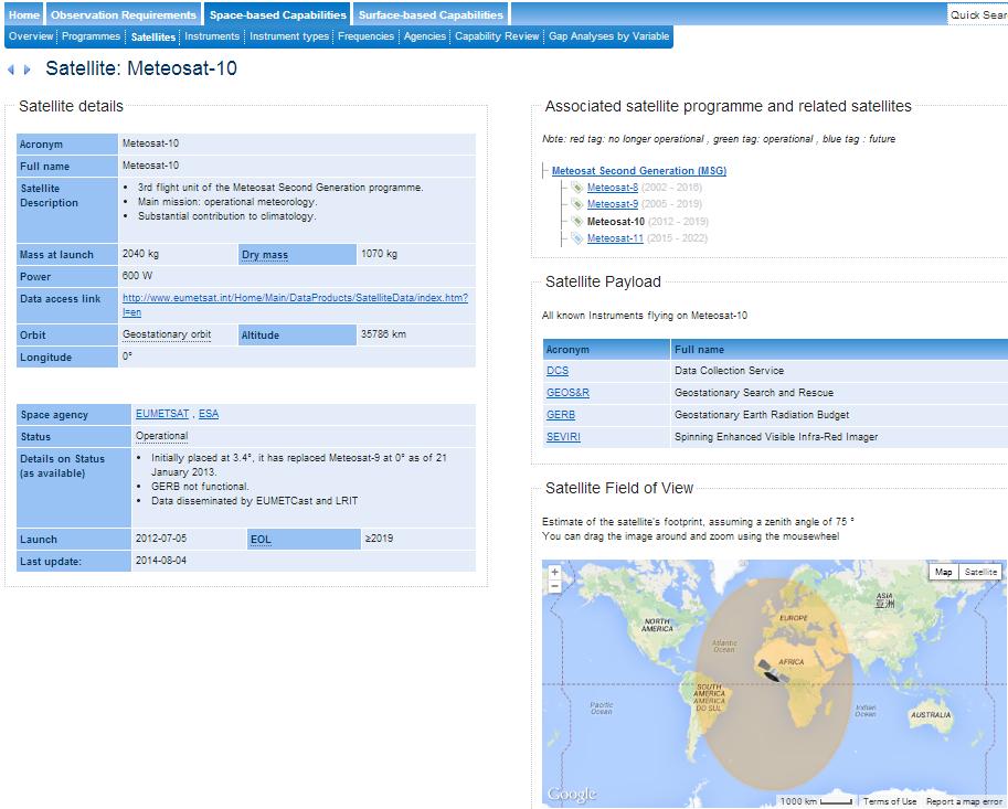
17 (2) OSCAR What it is? Observing Systems Capability Analysis and Review Tool(OSCAR) Web-based inventory and analysis tool One-stop portal on satellites, instruments, ground-segments OSCAR currently contains: Technical details on satellite programmes, mission and instruments as provided by agencies > 600 earth observation satellites and > 800 instruments with detailed characteristics A tentative evaluation of relevant categories of instruments for measuring physical variables Assessment also generates preliminary gaps analysis of these variables Assessment on how well actual and planned missions can respond to WMO Vision of the Global Observing System 17
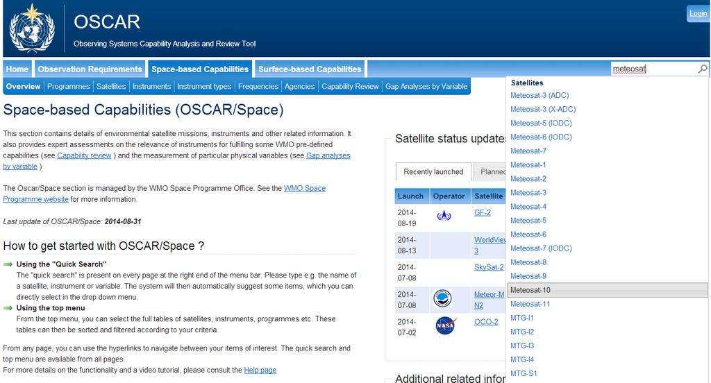
18 Link: 18
19 19

20 (2) OSCAR: Case of Mauritius 20

21 (2) OSCAR: Case of Mauritius 21
22 CGMS-42 : Considerations CGMS-42 WGIII actions: Indian Ocean Data Coverage (IODC) A42.01: WMO to dialogue with Indian Ocean satellite operators and clarify which data are essential in the sense of Resolution 40, in view of the meteorological requirements in the region. A42.08: ISRO and EUMETSAT to report at CGMS-43 on their discussions on data dissemination collaboration for SCATSAT data. A42.03 : WMO to consider sending a request to CMA for moving an FY-2 spacecraft over the Indian Ocean after successful launch and commissioning of FY-2G. A42.02 : EUMETSAT and ISRO will address the technical issues to accommodate high-resolution half-hourly data from INSAT-3D on dissemination means. Full CGMS-42 WGIII on: ( 22
23 (3) SATURN - General motivation and objective SATellite User Readiness Navigator Portal (SATURN) The generation of meteorological satellites provides: unprecedented capabilities for key meteorological applications such as nowcasting, as well as challenges for both satellite operators and users: Higher sampling rate, higher spatial resolution, more spectral channels Expected to lead to more accurate and timely forecasts, and improved application support Data rates increase drastically, by factors of CGMS and WMO Space Programme developed SATURN to allow Members exploit the potential operational and socio-economic benefits of using next-generation satellites Provides information on new generation of (initially) geostationary meteorological satellites: Himawari-8 (JMA), FY-4 (CMA), GOES-R (NOAA),GEO-KOMPSAT-2 (KMA), Elektro-L N2 (ROSHYDROMET), MTG (EUMETSAT) 23


24 SATURN Link: Instrument performance Operation plan Coverage area.. SATURN is currently populated with information on Himawari-8, ELEKTRO-L N2, FY-4A and GOES-R 24


25 SATURN: Example for Himawari-8 Note: PAG, OSCAR were tested on Chrome v36, Firefox v24 and Internet Explorer v 10, we advise that you used updated web browsers 25
26 Follow up on GIS Share GIS experience amongst NMHS in Africa WMO New software introduction considerations Planning and project approach very important Following the 5 phases for software introduction which includes: Preliminary, software requirement, preparation, implementation and consolidation phases. Each stage includes the exits strategy and best practices to increase probability of success Change management and human factor are very important Best way to choose a new software COTS Software Selection Process (Can also be used for Open Source) and 26
27 Summary on challenges and responses Challenges raised by RA I in 2012 WMO Survey Inadequate knowledge of available satellite products Mauritius being on the peripheral of the FOV of MSG 10 Information on new generation satellites Use of software tools Image interpretation GIS training and use Responses PAG populated with 86 product collections, 23 Training Materials and 12 International Expert Groups. Satellite providers are providing lists with more products to include in PAG Actions made by CGMS to address the IODC and using OSCAR to develop alternatives SATURN useful but currently partially populated List of possible software and training provided at WMO website RGB and satellite product use and interpretation training links Good planning and sharing experiences with other NMHS 27 Resources PAG CGMS, OSCAR SATURN WMO and Providers web pages EUMETrain and PAG (links) Best practice

28 Thank you for your attention Gillie Cheelo 28
Recommendations from RA III/RA IV SDR -2 Training Task Team (SDR-TTT)
") WORLD METEOROLOGICAL ORGANIZATION COORDINATION GROUP ON SATELLITE DATA REQUIREMENTS FOR REGION III AND IV Recommendations from RA III/RA IV SDR -2 Training Task Team (SDR-TTT) KATHY-ANN CAESAR CARIBBEAN
WORLD METEOROLOGICAL ORGANIZATION COORDINATION GROUP ON SATELLITE DATA REQUIREMENTS FOR REGION III AND IV Recommendations from RA III/RA IV SDR -2 Training Task Team (SDR-TTT) KATHY-ANN CAESAR CARIBBEAN
Status of EUMETSAT Operational Services & EUMETCast Africa Dissemination Baseline Updates
 Status of EUMETSAT Operational Services & EUMETCast Africa Dissemination Baseline Updates Sally Wannop User Relations Manager 1 8th WMO RAIDEG meeting 1-2 November 2017 # 951881 Overview EUMETCast Overview
EUMETSAT SAF NETWORK. Lothar Schüller, EUMETSAT SAF Network Manager
 1 EUMETSAT SAF NETWORK Lothar Schüller, EUMETSAT SAF Network Manager EUMETSAT ground segment overview METEOSAT JASON-2 INITIAL JOINT POLAR SYSTEM METOP NOAA SATELLITES CONTROL AND DATA ACQUISITION FLIGHT
WMO SPACE PROGRAMME ONLINE RESOURCES (Product Access Guide, Data Access Page, Tools Page) (Submitted by the Secretariat)
 (Submitted by the Secretariat)") WORLD METEOROLOGICAL ORGANIZATION COMMISSION FOR BASIC SYSTEMS OPEN PROGRAMME AREA GROUP ON INTEGRATED OBSERVING SYSTEMS INTER-PROGRAMME EXPERT TEAM ON SATELLITE UTILIZATION AND PRODUCTS SECOND SESSION
WORLD METEOROLOGICAL ORGANIZATION COMMISSION FOR BASIC SYSTEMS OPEN PROGRAMME AREA GROUP ON INTEGRATED OBSERVING SYSTEMS INTER-PROGRAMME EXPERT TEAM ON SATELLITE UTILIZATION AND PRODUCTS SECOND SESSION
EUMETSAT Training activities. Vesa Nietosvaara Mark Higgins
 EUMETSAT Training activities Vesa Nietosvaara Mark Higgins EUMETSAT Partnerships Europe: SAFs and regional networks EUMeTrain training recourses and tools Eumetcal coordination and infrastructure Africa:
Report. Northern Africa. RAIDEG-8, 1-2 Nov 2017
 Report Northern Africa RAIDEG-8, 1-2 Nov 2017 Report Northern Africa RAIDEG-8, 1-2 Nov 2017 Important Note: Formal letters have been sent from the PR of Morocco with WMO to PRs of Algeria, Tunisia, Libya
2 nd Cryonet-Asia Worskshop Salekhard, Russian Federation (2-5 February 2016)
") WMO 2 nd Cryonet-Asia Worskshop Salekhard, Russian Federation (2-5 February 2016) WMO Rolling Review of Requirements (RRR) Etienne Charpentier Chief, WMO Observing Systems Division WMO; Name of Department
WMO 2 nd Cryonet-Asia Worskshop Salekhard, Russian Federation (2-5 February 2016) WMO Rolling Review of Requirements (RRR) Etienne Charpentier Chief, WMO Observing Systems Division WMO; Name of Department
RAIDEG7 and GFCS needs. Mariane Diop Kane Chair of RAIDEG Director of Meteorology, ANACIM
 RAIDEG7 and GFCS needs Mariane Diop Kane Chair of RAIDEG Director of Meteorology, ANACIM RA-I Dissemination Expert Group (RAIDEG) Established in 2010 by WMO, in cooperation with EUMETSAT Endorsed by WMO
EUMETSAT SAF NETWORK. Lothar Schüller, EUMETSAT SAF Network Manager
 1 EUMETSAT SAF NETWORK Lothar Schüller, EUMETSAT SAF Network Manager EUMETSAT ground segment overview METEOSAT JASON-2 INITIAL JOINT POLAR SYSTEM METOP NOAA SATELLITES CONTROL AND DATA ACQUISITION FLIGHT
EUMETSAT s Support to Climate Services and User Support. Joachim Saalmüller
 EUMETSAT s Support to Climate Services and User Support Joachim Saalmüller 1 User Forum in Africa September 2016 Outline of my talk EUMETSAT in support of climate services Exploring our data and subscribing
EUMETSAT Satellite Programmes Use of McIDAS at EUMETSAT
 EUMETSAT Satellite Programmes Use of McIDAS at EUMETSAT Marianne König Peter Miu McIDAS Users' Group Meeting, 07-10 May 2012 Slide 1 EUMETSAT Headquarters Darmstadt McIDAS Users' Group Meeting, 07-10 May
CGMS Baseline In response to CGMS action/recommendation A45.01 HLPP reference: 1.1.8
 Prepared by WGIII Agenda Item: 7.1 Discussed in WGIII CGMS Baseline In response to CGMS action/recommendation A45.01 HLPP reference: 1.1.8 In CGMS-45, Working Group III agreed to hold a review of the CGMS
Update on SCOPE-Nowcasting Pilot Project Real Time Ocean Products Suman Goyal Scientist-E
 Update on SCOPE-Nowcasting Pilot Project Real Time Ocean Products Suman Goyal Scientist-E 19-22 Nov 2013 SCOPE-Nowcasting-1 Agenda Item 5 Pilot Projects Overview Users /Clients User requirements Product
Himawari 8/9 data distribution/dissemination plan
 Himawari 8/9 data distribution/dissemination plan Japan Meteorological Agency (JMA) Hidehiko MURATA Himawari is the name of this flower in Japanese ET SUP 8, WMO HQ, Geneva, 14 17 April 2014 1 Outline
7 th WMO RAI Dissemination Expert working Group RAIDEG report. Mariane Diop Kane, Chair
 7 th WMO RAI Dissemination Expert working Group RAIDEG report Mariane Diop Kane, Chair Overview Established in 2010 by WMO, in cooperation with EUMETSAT Endorsed by WMO RA-I at its 16 th session in 2015,
Joint RA II/V Workshop on WIGOS for DRR - The Jakarta Declaration - (12-14 October, Jakarta, Indonesia) NMSC/KMA
 NMSC/KMA") Joint RA II/V Workshop on WIGOS for DRR - The Jakarta Declaration - (12-14 October, Jakarta, Indonesia) /KMA dolong@korea.kr Background Enhancement of Member s capabilities for weather forecasts and warnings
Joint RA II/V Workshop on WIGOS for DRR - The Jakarta Declaration - (12-14 October, Jakarta, Indonesia) /KMA dolong@korea.kr Background Enhancement of Member s capabilities for weather forecasts and warnings
METEOSAT THIRD GENERATION
 METEOSAT THIRD GENERATION FACTS AND FIGURES MONITORING WEATHER AND CLIMATE FROM SPACE A HIGHLY INNOVATIVE GEOSTATIONARY SATELLITE SYSTEM FOR EUROPE AND AFRICA The Meteosat Third Generation (MTG) system
Himawari-8 RGB product use and development amongst Australian / RAV / RAII stakeholders: the Australian VLab Centre of Excellence perspective
 Himawari-8 RGB product use and development amongst Australian / RAV / RAII stakeholders: the Australian VLab Centre of Excellence perspective EUMeTrain Event Week on MTG-I satellite 7-11 November 2016
Weather Forecasting in Flood Forecasting Activities
 Weather Forecasting in Flood Forecasting Activities Eugene Poolman South African Weather Service Representing CBS Pretoria South Africa FCAST PRES 20130919 001 Main Activities of CBS Development, implementation
CGMS Baseline. Sustained contributions to the Global Observing System. Endorsed by CGMS-46 in Bengaluru, June 2018
 CGMS Baseline Sustained contributions to the Global Observing System Best Practices for Achieving User Readiness for New Meteorological Satellites Endorsed by CGMS-46 in Bengaluru, June 2018 CGMS/DOC/18/1028862,
Introduction of JMA VLab Support Site on RGB Composite Imagery and tentative RGBs
 The Sixth Asia/Oceania Meteorological Satellite Users' Conference 9 13 November 2015, Tokyo/Japan J M A Introduction of JMA VLab Support Site on RGB Composite Imagery and tentative RGBs Akihiro SHIMIZU
A Questionnaire on the Utilization of Satellite Data from the New Generation of Geostationary Meteorological Satellites
 3.1 User requirements for satellite data utilization, especially for new-generation satellites A Questionnaire on the Utilization of Satellite Data from the New Generation of Geostationary Meteorological
WMO Space Programme SP-8. Status of the availability and use of satellite data and products by WMO Members For the period WMO-TD No.
 WMO Space Programme SP-8 Status of the availability and use of satellite data and products by WMO Members For the period 2008 2009 WMO-TD No. 1567 WMO Space Programme SP 8 Status of the availability and
The importance of satellite data and products for RA1 in the WWRP strategy. Estelle de Coning World Weather Research Division
 The importance of satellite data and products for RA1 in the WWRP strategy Estelle de Coning World Weather Research Division Kofi Annan former UN Secretary-General (21 July 2016) "The poor need alerts
WMO Priorities and Perspectives on IPWG
 WMO Priorities and Perspectives on IPWG Stephan Bojinski WMO Space Programme IPWG-6, São José dos Campos, Brazil, 15-19 October 2012 1. Introduction to WMO Extended Abstract The World Meteorological Organization
EUMETSAT products and services for monitoring storms - New missions, more data and more meteorological products
 EUMETSAT products and services for monitoring storms - New missions, more data and more meteorological products Jochen Grandell 1 EUM/RSP/VWG/17/921460 Outline Overview of EUMETSAT missions Current...and
RECOMMENDATIONS OF THE 10 TH EUMETSAT USER FORUM IN AFRICA 1 OCTOBER - 5 OCTOBER 2012, Addis Ababa, Ethiopia
 RECOMMENDATIONS OF THE 10 TH EUMETSAT USER FORUM IN AFRICA 1 OCTOBER - 5 OCTOBER 2012, Addis Ababa, Ethiopia Sorted by: 1. Data and products (access and dissemination) recommendations #1 to #8 2. Training
Preparation for Himawari 8
 Preparation for Himawari 8 Japan Meteorological Agency Meteorological Satellite Center Hidehiko MURATA ET SUP 8, WMO HQ, Geneva, 14 17 April 2014 1/18 Introduction Background The Japan Meteorological Agency
EUMETSAT. A global operational satellite agency at the heart of Europe. Presentation for the Spanish Industry Day Madrid, 15 March 2012
 EUMETSAT A global operational satellite agency at the heart of Europe Presentation for the Spanish Industry Day Madrid, Angiolo Rolli EUMETSAT Director of Administration EUMETSAT objectives The primary
Benefits of the new-generation Himawari-8 geostationary satellite for the Asia-Pacific region. Toshihiko HASHIDA Japan Meteorological Agency (JMA)
") Benefits of the new-generation Himawari-8 geostationary satellite for the Asia-Pacific region Toshihiko HASHIDA Japan Meteorological Agency (JMA) Side Event Ensuring User Readiness to New-Generation Meteorological
Benefits of the new-generation Himawari-8 geostationary satellite for the Asia-Pacific region Toshihiko HASHIDA Japan Meteorological Agency (JMA) Side Event Ensuring User Readiness to New-Generation Meteorological
Satellite And Weather Information (SAWIDRA)/RARS
/RARS") Satellite And Weather Information for Disaster Resilience in Africa (SAWIDRA)/RARS Benjamin Lamptey, PhD ACMAD bllamptey@gmail.com EU funding and overall context 1. EUR 80 million Intra ACP Programme Building
Satellite And Weather Information for Disaster Resilience in Africa (SAWIDRA)/RARS Benjamin Lamptey, PhD ACMAD bllamptey@gmail.com EU funding and overall context 1. EUR 80 million Intra ACP Programme Building
Monitoring Sand and Dust Storms from Space
 Monitoring Sand and Dust Storms from Space for Expert Consultation on Disaster Information and Knowledge, Session 2 ICC 21 for ESCAP s RESAP and CDRR 5 9 12 October, 2017 Toshiyuki KURINO WMO Space Programme
RGB Experts and Developers Workshop - Introduction Tokyo, Japan 7-9 Nov 2017
 RGB Experts and Developers Workshop - Introduction Tokyo, Japan 7-9 Nov 2017 Workshop Objectives Review of existing RGB standards Reconfirm and extend existing standards (new multi-spectral imagers) Stimulate
WMO Space Programme SP-4. Status of the availability and use of satellite data and products by WMO Members For the period WMO-TD No.
 WMO Space Programme SP-4 Status of the availability and use of satellite data and products by WMO Members For the period 2004 2005 WMO-TD No. 1423 STATUS OF THE AVAILABILITY AND USE OF SATELLITE DATA AND
Status report on current and future satellite systems by EUMETSAT Presented to CGMS-44, Plenary session, agenda item D.1
 Status report on current and future satellite systems by EUMETSAT Presented to CGMS-44, Plenary session, agenda item D.1 CGMS-44-EUMETSAT-WP-19.ppt, version 1 (# 859110), 8 June 2016 MISSION PLANNING YEAR...
WMO Space Programme: anticipated evolution and a Picture of Development of a Vision of WIGOS Space-based Component in 2040
 WMO Space Programme: anticipated evolution and a Picture of 2040 --Development of a Vision of WIGOS Space-based Component in 2040 Wenjian Zhang Director, Observing and Information Systems Department &
FUTURE PLAN AND RECENT ACTIVITIES FOR THE JAPANESE FOLLOW-ON GEOSTATIONARY METEOROLOGICAL SATELLITE HIMAWARI-8/9
 FUTURE PLAN AND RECENT ACTIVITIES FOR THE JAPANESE FOLLOW-ON GEOSTATIONARY METEOROLOGICAL SATELLITE HIMAWARI-8/9 Toshiyuki Kurino Japan Meteorological Agency, 1-3-4 Otemachi Chiyodaku, Tokyo 100-8122,
Regional Flash Flood Guidance and Early Warning System
 WMO Training for Trainers Workshop on Integrated approach to flash flood and flood risk management 24-28 October 2010 Kathmandu, Nepal Regional Flash Flood Guidance and Early Warning System Dr. W. E. Grabs
WMO SCOPE-Nowcasting using new-generation satellite data: Progress and Perspectives
 WMO SCOPE-Nowcasting using new-generation satellite data: Progress and Perspectives Stephan Bojinski WMO Space Programme 8 th Asia-Oceania Meteorological Satellite Users Conference Vladivostok, Russia,
A 2016 CEOS Chair Initiative. Non-meteorological Applications for Next Generation Geostationary Satellites
 A 2016 CEOS Chair Initiative Committee on Earth Observation Satellites Non-meteorological Applications for Next Generation Geostationary Satellites Co-chaired by EUMETSAT (Holmlund), CSIRO (Schroeder),
International Desks: African Training Desk and Projects
 The Climate Prediction Center International Desks: African Training Desk and Projects Wassila M. Thiaw Team Leader Climate Prediction Center National Centers for Environmental Predictions 1 African Desk
Preparing for NOAA s Next Generation GOES-R & JPSS
 Preparing for NOAA s Next Generation GOES-R & JPSS Mark Paese Deputy Assistant Administrator NOAA Environmental Satellite & Information Service (NESDIS) WMO Cg-17: Ensuring User Readiness for New Generation
Non-meteorological Applications for Next Generation Geostationary Satellites: A 2016 CEOS Chair Initiative
 Committee on Earth Observation Satellites Non-meteorological Applications for Next Generation Geostationary Satellites: A 2016 CEOS Chair Initiative Ian Grant, Australian Bureau of Meteorology (Adapted
Instrumentation planned for MetOp-SG
 Instrumentation planned for MetOp-SG Bill Bell Satellite Radiance Assimilation Group Met Office Crown copyright Met Office Outline Background - the MetOp-SG programme The MetOp-SG instruments Summary Acknowledgements:
TCC Recent Development and Activity
 11 May 2015, FOCRAII TCC Recent Development and Activity Yasushi MOCHIZUKI Tokyo Climate Center Japan Meteorological Agency TCC Recent Development and Activity / Tokyo Climate Center Tokyo Climate Center
Updates on Chinese Meteorological Satellite Programs
 6 th Asia/Oceania Meteorological Satellite Users Conference Updates on Chinese Meteorological Satellite Programs Caiying Wei Deputy director-general of NSMC National Satellite Meteorological Center (NSMC)
World Meteorological Organization Working together in weather, climate and water
 WMO World Meteorological Organization Working together in weather, climate and water Strengthening Regional Cooperation to Support Forecasting with Multi-Hazard Approach in RA IV SWFDP concepts and lessons
WMO 2016 Survey on the Use of Satellite Data
 WMO 2016 Survey on the Use of Satellite Data World Meteorological Organization (WMO) Space Programme 5 th Meeting of the Coordinating Group for the RA II WIGOS Project to Develop Support for NMHSs in Satellite
Tokyo Climate Center Website (TCC website) and its products -For monitoring the world climate and ocean-
 and its products -For monitoring the world climate and ocean-") Tokyo, 14 November 2016, TCC Training Seminar Tokyo Climate Center Website (TCC website) and its products -For monitoring the world climate and ocean- Yasushi MOCHIZUKI Tokyo Climate Center Japan Meteorological
Tokyo, 14 November 2016, TCC Training Seminar Tokyo Climate Center Website (TCC website) and its products -For monitoring the world climate and ocean- Yasushi MOCHIZUKI Tokyo Climate Center Japan Meteorological
EUMETSAT Activities Related to Climate
 EUMETSAT Activities Related to Climate Jörg Schulz joerg.schulz@eumetsat.int Slide: 1 What we do USER REQUIREMENTS European National Meteorological Services Operating Agency! European Space Industry Private
Country Report - Singapore
 Country Report - Singapore The 5th Meeting of the Coordinating Group Vladivostok city, Russky Island, Russia Far Eastern Federal University of the RA II WIGOS Satellite Project 21 October 2017 Outline
Progress on GCOS-China CMA IOS Development Plan ( ) PEI, Chong Department of Integrated Observation of CMA 09/25/2017 Hangzhou, China
 PEI, Chong Department of Integrated Observation of CMA 09/25/2017 Hangzhou, China") Progress on GCOS-China CMA IOS Development Plan (2016-2020) PEI, Chong Department of Integrated Observation of CMA 09/25/2017 Hangzhou, China 1. Progress on GCOS-China 1 Organized GCOS-China GCOS-China
Progress on GCOS-China CMA IOS Development Plan (2016-2020) PEI, Chong Department of Integrated Observation of CMA 09/25/2017 Hangzhou, China 1. Progress on GCOS-China 1 Organized GCOS-China GCOS-China
Inventory & Evaluation of Space-based Instruments: Using OSCAR for space weather
 WMO OMM World Meteorological Organization Working together in weather, climate and water Inventory & Evaluation of Space-based Instruments: Using OSCAR for space weather Jérôme Lafeuille (WMO) Alain Hilgers
INDIAN OCEAN DATA COVERAGE (IODC) - CGMS ROADMAP
 - CGMS ROADMAP") Prepared by EUMETSAT Agenda Item: 2.3 WGIII/2.3 and Plenary G.4.2 Discussed in WGIII and Plenary INDIAN OCEAN DATA COVERAGE (IODC) - CGMS ROADMAP In response to CGMS actions/recommendations: EUM WGIII/2.2
Prepared by EUMETSAT Agenda Item: 2.3 WGIII/2.3 and Plenary G.4.2 Discussed in WGIII and Plenary INDIAN OCEAN DATA COVERAGE (IODC) - CGMS ROADMAP In response to CGMS actions/recommendations: EUM WGIII/2.2
National Public Weather and Warning Services in the Swaziland Meteorological Service Dennis S.Mkhonta /
 National Public Weather and Warning Services in the Swaziland Meteorological Service Dennis S.Mkhonta dennis.mkhonta@gmail.com / dennis@swazimet.gov.sz Introduction Swaziland s geographical position exposes
WMO Coordination Group on Satellite Data Requirements for Region III and IV Sept 5-8, 2016 Willemstad, Curaçao
 WMO Coordination Group on Satellite Data Requirements for Region III and IV Sept 5-8, 2016 Willemstad, Curaçao 1. Current Satellite Reception 2. Preparation for Next-Gen GOES-R JPSS 3. Satellite Data Applications
WMO OSCAR. Observing Systems Capability Analysis and Review Tool A building block of Rolling Requirements Review
 WMO OSCAR Observing Systems Capability Analysis and Review Tool A building block of Rolling Requirements Review Quantitative user-defined requirements for observation of physical variables in application
NWC-SAF Satellite Application Facility in Support to Nowcasting and Very Short Range Forecasting
 NWC-SAF Satellite Application Facility in Support to Nowcasting and Very Short Range Forecasting Marianne König Slide 1 Satellite Application Facilities (SAFs) in Europe Member State Cooperating State
Satellite observation of atmospheric dust
 Satellite observation of atmospheric dust Taichu Y. Tanaka Meteorological Research Institute, Japan Meteorological Agency 11 April 2017, SDS WAS: Dust observation and modeling @WMO, Geneva Dust observations
COUNTRY REPORT INDONESIA
 COUNTRY REPORT INDONESIA Badan Meteorologi Klimatologi dan Geofisika (BMKG) Agency For Meteorology, Climatology, and Geophysics Republic of Indonesia DKI Jakarta, Indonesia Tel. (021) 4246321 Email: pcs@bmkg.go.id
DRARS Coordination Meeting Contribution from IMD
 DRARS Coordination Meeting Contribution from IMD Dr. Ashim Kumar Mitra Ministry of Earth Sciences India Meteorological Department New Delhi-INDIA 11-13 March 2015 The Processing System of NOAA/METOP/MODIS
Inter-Programme Team on Space Weather Information, Systems and Services (IPT-SWISS)
") Inter-Programme Team on Space Weather Information, Systems and Services (IPT-SWISS) Toshiyuki KURINO WMO Space Programme Office WMO Space Programme OSCAR/Requirements (Observing Requirements Database)
Inter-Programme Team on Space Weather Information, Systems and Services (IPT-SWISS) Toshiyuki KURINO WMO Space Programme Office WMO Space Programme OSCAR/Requirements (Observing Requirements Database)
NEW CGMS BASELINE FOR THE SPACE-BASED GOS. (Submitted by the WMO Secretariat) Summary and Purpose of Document
 Summary and Purpose of Document") WORLD METEOROLOGICAL ORGANIZATION COMMISSION FOR BASIC SYSTEMS OPEN PROGRAMME AREA GROUP ON INTEGRATED OBSERVING SYSTEMS EXPERT TEAM ON SATELLITE SYSTEMS ET-SAT-7/Inf. 2 (12.III.2012) ITEM: 8.1 SEVENTH
WORLD METEOROLOGICAL ORGANIZATION COMMISSION FOR BASIC SYSTEMS OPEN PROGRAMME AREA GROUP ON INTEGRATED OBSERVING SYSTEMS EXPERT TEAM ON SATELLITE SYSTEMS ET-SAT-7/Inf. 2 (12.III.2012) ITEM: 8.1 SEVENTH
Tonga Country Report
 Tonga Country Report Tonga Meteorological Services Ph. (676)35355 email: metstaff@met.gov.to Joint Meeting of RA II WIGOS Project and RA V TT-SU Jakarta, Indonesia / 11 October 2018 BMKG Headquarter Outline
WMO Space Programme: Update
 WMO OMM World Meteorological Organization Working together in weather, climate and water WMO Space Programme: Update Stephan Bojinski Virtual Lab Management Group, 6 th Meeting 8-11 October 2012, São José
Smart use of Geographic Information System (GIS) platform for delivering weather information and nowcasting services
 platform for delivering weather information and nowcasting services") Smart use of Geographic Information System (GIS) platform for delivering weather information and nowcasting services C. K. Pan Hong Kong Observatory Hong Kong, China It is a world of beauty Source: Image
Smart use of Geographic Information System (GIS) platform for delivering weather information and nowcasting services C. K. Pan Hong Kong Observatory Hong Kong, China It is a world of beauty Source: Image
VISION FOR THE GOS IN 2025 ( Approved by CBS-XIV and Adopted by EC LXI in June 2009)
") WORLD METEOROLOGICAL ORGANIZATION Weather Climate Water VISION FOR THE GOS IN 2025 ( Approved by CBS-XIV and Adopted by EC LXI in June 2009) PREAMBLE This Vision provides high-level goals to guide the
WORLD METEOROLOGICAL ORGANIZATION Weather Climate Water VISION FOR THE GOS IN 2025 ( Approved by CBS-XIV and Adopted by EC LXI in June 2009) PREAMBLE This Vision provides high-level goals to guide the
Applications of multi-spectral satellite data
 Applications of multi-spectral satellite data Jochen Kerkmann EUMETSAT, Satellite Meteorologist, Training Officer Adjusted by E de Coning South African Weather Service Content 1. Why should we use RGBs?
WMO Integrated Global Observing Systems (WIGOS) and the QA4EO
 and the QA4EO") WMO OMM World Meteorological Organization Working together in weather, climate and water WMO Integrated Global Observing Systems (WIGOS) and the QA4EO J. Lafeuille WMO Space Programme WMO www.wmo.int Outline
WMO OMM World Meteorological Organization Working together in weather, climate and water WMO Integrated Global Observing Systems (WIGOS) and the QA4EO J. Lafeuille WMO Space Programme WMO www.wmo.int Outline
CLIMATE CHANGE ADAPTATION BY MEANS OF PUBLIC PRIVATE PARTNERSHIP TO ESTABLISH EARLY WARNING SYSTEM
 CLIMATE CHANGE ADAPTATION BY MEANS OF PUBLIC PRIVATE PARTNERSHIP TO ESTABLISH EARLY WARNING SYSTEM By: Dr Mamadou Lamine BAH, National Director Direction Nationale de la Meteorologie (DNM), Guinea President,
EUMETSAT Satellite Status
 EUMETSAT Satellite Status Dr. K. Dieter Klaes EUMETSAT 1 ET-SAT Meeting 4-6 April 2017, WMO, Geneva, Switzerland EUMETSAT is an intergovernmental organisation with 30 Member States and 1 Cooperating State
An Eye in the Sky EUMETSAT. Monitoring Weather, Climate and the Environment
 An Eye in the Sky EUMETSAT Monitoring Weather, Climate and the Environment Slide: 1 Hazardous Weather Slide: 2 Hazardous Weather Slide: 3 Natural Disasters set off by severe weather Slide: 4 EUMETSAT Objectives...
EUMETSAT AGENCY REPORT 2014/15 INSTRUMENT CAL/VAL ACTIVITIES
 1 WGCV Plenary #39, Berlin, May 2015 EUMETSAT AGENCY REPORT 2014/15 INSTRUMENT CAL/VAL ACTIVITIES J. Ackermann, S. Elliott, T. Hewison, K. Holmlund, V. John, R. Munro, P. Miu, A. O Carroll, R. Roebeling,
Current status of operations of SWIOCOF. François BONNARDOT Head of Climate Division Météo-France, Direction Interrégionale pour l Océan Indien
 Current status of operations of SWIOCOF François BONNARDOT Head of Climate Division Météo-France, Direction Interrégionale pour l Océan Indien WMO International Workshop on Global Review of Regional Climate
Status and Plans of Next Generation Japanese Geostationary Meteorological Satellites Himawari 8/9
 Status and Plans of Next Generation Japanese Geostationary Meteorological Satellites Himawari 8/9 Masahiro Hayashi 1, Kotaro Bessho 1, and Tomoo Ohno 2 1: JMA/Meteorological Satellite Center (MSC) 2: JMA/Satellite
AMDAR Global Status, Benefits and Development Plans*
 AMDAR Global Status, Benefits and Development Plans* WMO CBS ET Aircraft Based Observations Bryce Ford * Adapted from Presentation at WMO Congress XVII, June 2015 by WMO CBS President, reviewed by WMO
STATUS AND DEVELOPMENT OF SATELLITE WIND MONITORING BY THE NWP SAF
 STATUS AND DEVELOPMENT OF SATELLITE WIND MONITORING BY THE NWP SAF Mary Forsythe (1), Antonio Garcia-Mendez (2), Howard Berger (1,3), Bryan Conway (4), Sarah Watkin (1) (1) Met Office, Fitzroy Road, Exeter,
BMKG UPDATES ON SATELLITE-RELATED ACTIVITIES IN RA V
 UPDATES ON SATELLITE-RELATED ACTIVITIES IN RA V Riris Adriyanto (BMKG Indonesia / Member RA V TT-SU) With inputs from : Agnes Lane (Australian BoM / Leader RA V TT-SU) 1 Introduction Throughout these years,
The National Meteorological Services Agency Satellite Data reception and processing unit First phase by Yitaktu Tesfatsion
 The National Meteorological Services Agency Satellite Data reception and processing unit First phase by Yitaktu Tesfatsion In Ethiopia the rain guage network is not evenly distributed over the country.
GSCB Workshop 2009: EUMETSAT Missions
 GSCB Workshop 2009: EUMETSAT Missions Dr. Harald Rothfuss, EUMETSAT. GSCB Workshop 2007, ESRIN, Frascati, 18-19 June 2009. Slide: 1 Introduction To EUMETSAT The European Organisation for the Exploitation
REVISION OF THE STATEMENT OF GUIDANCE FOR GLOBAL NUMERICAL WEATHER PREDICTION. (Submitted by Dr. J. Eyre)
") WORLD METEOROLOGICAL ORGANIZATION Distr.: RESTRICTED CBS/OPAG-IOS (ODRRGOS-5)/Doc.5, Add.5 (11.VI.2002) COMMISSION FOR BASIC SYSTEMS OPEN PROGRAMME AREA GROUP ON INTEGRATED OBSERVING SYSTEMS ITEM: 4 EXPERT
WORLD METEOROLOGICAL ORGANIZATION Distr.: RESTRICTED CBS/OPAG-IOS (ODRRGOS-5)/Doc.5, Add.5 (11.VI.2002) COMMISSION FOR BASIC SYSTEMS OPEN PROGRAMME AREA GROUP ON INTEGRATED OBSERVING SYSTEMS ITEM: 4 EXPERT
Maryland Space. Business Roundtable. Satellite and Information Service. Stephen Volz, Ph.D., Assistant Administrator. January 2018
 Maryland Space Satellite and Information Service Business Roundtable Stephen Volz, Ph.D., Assistant Administrator January 2018 Delivering on the Commitment JPSS-1 Launch Nov 18, 2017 GOES-R Launch Nov
The importance of satellite data for nowcasting in the WWRP strategy
 The importance of satellite data for nowcasting in the WWRP strategy Estelle de Coning and Paolo Ruti World Weather Research Division Steve Goodman Chief Program Scientist, NOAA WMO definition Nowcasting
Copernicus Today and Tomorrow GEO Week Group on Earth Observation Geneva, 16 January 2014 The Copernicus Space Infrastructure
 Copernicus Today and Tomorrow GEO Week Group on Earth Observation Geneva, 16 January 2014 The Copernicus Space Infrastructure Thomas Beer, Policy Coordinator, Copernicus Space Office, ESA-ESRIN, Frascati
Creating a WeatherSMART nation: SAWS drought related research, services and products
 Creating a WeatherSMART nation: SAWS drought related research, services and products Drought Dialogue 23-24 June 2016 Western Cape Government Hannes Rautenbach South African Weather Service SAWS mandate
RCOF Review [Regional Climate Outlook Forum for the Gulf of Guinea region of Africa - PRESAGG] Status Report
![RCOF Review [Regional Climate Outlook Forum for the Gulf of Guinea region of Africa - PRESAGG] Status Report](/thumbs/78/77466191.jpg "RCOF Review [Regional Climate Outlook Forum for the Gulf of Guinea region of Africa - PRESAGG] Status Report") RCOF Review 2017 [Regional Climate Outlook Forum for the Gulf of Guinea region of Africa - PRESAGG] Status Report Specific Climate features of concerned region This region typically covers the area below
RCOF Review 2017 [Regional Climate Outlook Forum for the Gulf of Guinea region of Africa - PRESAGG] Status Report Specific Climate features of concerned region This region typically covers the area below
Himawari-8 BUFR Development for Winds Processing and Radiances Cloud Mask, Cloud Phase, Cloud Height
 Sandy Supplemental Grant Recipient Quarterly Progress Report Himawari-8 BUFR Development for Winds Processing and Radiances Award Number: NA14NES4830006 The National Oceanic and Atmospheric Administration
REPORT ON EUMETCAST INCLUDING GEONETCAST
 Prepared by EUMETSAT Agenda Item: F.2 Discussed in Plenary REPORT ON EUMETCAST INCLUDING GEONETCAST This paper presents the actual status of the system architecture, data services supported, and registration
COORDINATION GROUP FOR METEOROLOGICAL SATELLITES AND GOFC-GOLD
 Coordination Group for Meteorological Satellites - CGMS COORDINATION GROUP FOR METEOROLOGICAL SATELLITES AND GOFC-GOLD Mitch Goldberg, CGMS co-liaison to CGMS Working group 2 satellite data and products
Satellite User Readiness through Training: VISIT, SHyMet, WMO VLab, and Liaisons
 Satellite User Readiness through Training: VISIT, SHyMet, WMO VLab, and Liaisons Bernadette Connell 1 D. Bikos 1, S. Lindstrom 2, J. Torres 1, E. J. Szoke 1, E. L. Dagg 1, A. B. Schumacher 1, A. S. Bachmeier
Meteorological instruments and observations methods: a key component of the Global Earth Observing System of Systems (GEOSS)
") GLOBAL OBSERVING SYSTEMS Instruments and Methods of Observation Programme Meteorological instruments and observations methods: a key component of the Global Earth Observing System of Systems (GEOSS) Dr.
GLOBAL OBSERVING SYSTEMS Instruments and Methods of Observation Programme Meteorological instruments and observations methods: a key component of the Global Earth Observing System of Systems (GEOSS) Dr.
A Review of the Australian VLab Centre of Excellence National Himawari-8 Training Campaign. AOMSUC-6 Conference Session
 A Review of the Australian VLab Centre of Excellence National Himawari-8 Training Campaign AOMSUC-6 Conference Session Bodo Zeschke Australian Bureau of Meteorology Training Centre Australian VLab Centre
EUMETSAT PLANS. Dr. K. Dieter Klaes EUMETSAT Am Kavalleriesand 31 D Darmstadt Germany
 EUMETSAT PLANS Dr. K. Dieter Klaes EUMETSAT Am Kavalleriesand 31 D-64295 Darmstadt Germany Page 1 EUMETSAT SATELLITE PROGRAMMES 96 97 98 99 00 01 02 03 04 05 06 07 08 09 10 11 12 13 14 15 16 17 18 METEOSAT
file://c:\documents and Settings\Best J\Local Settings\Temp\XPgrpwise\4B950198WM...
 file://c:\documents and Settings\Best J\Local Settings\Temp\XPgrpwise\4B950198WM... Page 1 of 1 3/9/2010 Jennifer Best - Updates to WMO Publication No.9 Volume C2 From: To:
Review of AOMSUC-9 Country Report. by : Riris Adriyanto BMKG Indonesia
 Review of AOMSUC-9 Country Report by : Riris Adriyanto BMKG Indonesia OUTLINE Collection and Processing of Satellite Data Satellite-Bases Product Used Regional Challenges Training and Infrastucture Need
Overview of Himawari-8/9
 Overview of Himawari-8/9 Toshiyuki SAKURAI Meteorological Satellite Center (MSC) Japan Meteorological Agency (JMA) EUMeTrain Event Week on MTG-I Satellite 2016 Session2 - Himawari-8 and Data Applications
Transboundary water management with Remote Sensing. Oluf Jessen DHI Head of Projects, Water Resources Technical overview
 Transboundary water management with Remote Sensing Oluf Jessen DHI Head of Projects, Water Resources Technical overview ozj@dhigroup.com Transboundary water management Water management across national
Status report on the current and future meteorological satellite systems by CMA
 Status report on the current and future meteorological satellite systems by CMA Presented to CGMS-44Plenary session, agenda item [D.1] Overview - Planning of China satellite systems by year 2025 NSIP:
Data Exchange and Dissemination Status in Regions: WMO RA I. (S. Wannop, EUMETSAT, and I. Gitonga, KMD) Summary and Purpose of Document
 Summary and Purpose of Document") WORLD METEOROLOGICAL ORGANIZATION COMMISSION FOR BASIC SYSTEMS OPEN PROGRAMME AREA GROUP ON INTEGRATED OBSERVING SYSTEMS INTER-PROGRAMME EXPERT TEAM ON SATELLITE UTILIZATION AND PRODUCTS SECOND SESSION
WORLD METEOROLOGICAL ORGANIZATION COMMISSION FOR BASIC SYSTEMS OPEN PROGRAMME AREA GROUP ON INTEGRATED OBSERVING SYSTEMS INTER-PROGRAMME EXPERT TEAM ON SATELLITE UTILIZATION AND PRODUCTS SECOND SESSION
Himawari-8 True Color RGB
 Himawari-8 True Color RGB Meteorological Satellite Center, JMA Ver. 20150519 What s True Color RGB? R : B03(VS 0.64) G : B02(V2 0.51) 2015-03-17 00UTC B : B01(V1 0.46) Components of True Color RGB Channel