The GOES-R Rainfall Rate, Rainfall Potential, and Probability of Rainfall Algorithms
|
|
|
- Jocelyn Bryan
- 5 years ago
- Views:
Transcription
1 The GOES-R Rainfall Rate, Rainfall Potential, and Probability of Rainfall Algorithms Bob Kuligowski, NOAA/NESDIS/STAR Yaping Li, Zhihua Zhang, Richard Barnhill, I. M. Systems Group 5 th International Precipitation Working Group (IPWG) Workshop Hamburg, Germany, 12 October
2 Outline Review of GOES-R Status and Capabilities GOES-R RAlgorithm Working Group Algorithm Descriptions and Examples» Rainfall Rate Algorithm» Rainfall Potential Algorithm» Probability of Rainfall Algorithm Algorithm Validation Status and Future Work Summary 2
3 Review of GOES-R Status and Capabilities i Anticipated launch in late 2015 Advanced Baseline Imager (ABI) Increase from 5 to 16 spectral bands Improved spatial resolution (4 2 km IR; km VIS) Faster scanning (5-min full disk vs. 30 min) GOES Lightning i Mapper (GLM) Detects total lightning, not just cloud-to-ground Single-channel, near-ir optical detector Spatial resolution of ~10 km 3
 working together to develop a prototype")
» Probability of Rainfall")
, Chair Ralph Ferraro")
 Sheldon Kusselson (OSDPD/SSD/SAB) Matthew")
4 GOES-R Algorithm Working G (A G) Group (AWG) Algorithm Teams (AT s) working together to develop a prototype GOES-R ground processing system Hydrology AT Products:» Rainfall Rate / QPE (current)» Probability of Rainfall (next 0-3 h)» Rainfall Potential (next 0-3h) Hydrology AT Members: Bob Kuligowski (STAR/SMCD), Chair Ralph Ferraro (STAR/CORP) Kuo-Lin Hsu (UC-Irvine) George Huffman (NASA-GSFC/SSAI) Sheldon Kusselson (OSDPD/SSD/SAB) Matthew Sapiano (UMCP/ESSIC) 4


5 Rainfall Rate Algorithm D i i Description IR algorithm calibrated in real time using MW rain rates» IR continuously available, but weaker relationship to rain rate» MW more strongly related to rain rate, but available ~every 3 h Calibration by type and region» Three cloud types: Water cloud : T 7.34 <T 11.2 and T 8.5 -T 11.2 <-0.3 "Ice cloud": T 7.34 <T 11.2 and T 8.5 -T "Cold-top convective cloud": T T 11.2» Four geographic regions: 60-30ºS, 30ºS-EQ, EQ-30ºN, 30-60ºN Two retrieval steps:» Rain / no rain separation via discriminant analysis» Rain rate via multiple linear regression 5
6 Rainfall Rate Algorithm Description i 8 predictors derived from 5 ABI bands T 6.19 T T 7.34 S = (T min, K) T T 7.34 T avg, T min, S T T 11.2 T T 6.19 T T additional nonlinear predictors» Regressed against the MW rain rates in log-log space 6


7 Rainfall Rate Algorithm Description i Initial SCaMPR rain rates strongly gyunderestimate heavy rain Adjust distribution» For each class and region, match the CDF of the SCaMPR rain rates against the CDF of the target MW rain rates» Create an interpolated LUT to modify the SCaMPR rain rate distribution 7


8 Rainfall Rate Algorithm Description i Apply most recent calibration in between new MW overpasses Update calibration when new MW rain rates available Retrieve rain rates from ABI data 8


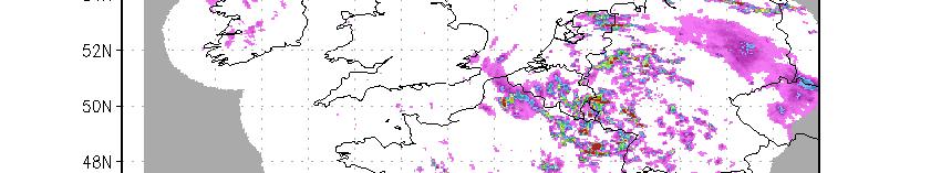

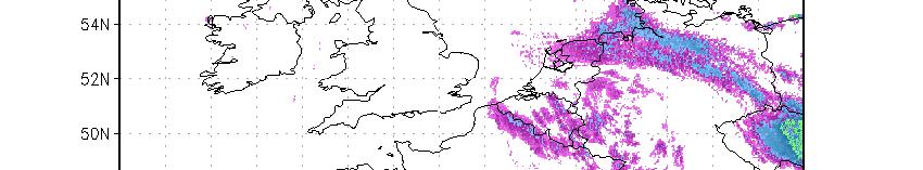
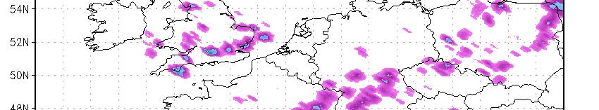
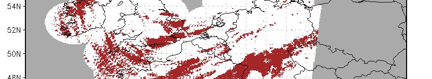
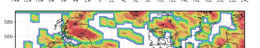
9 Rainfall Rate Examples Radar Rainfall Rate 9
10 Rainfall Potential Algorithm Description Identify features (clusters) in Rainfall Rate imagery» Filter rain rate image to reduce noise» Use cost minimization to organize pixels into clusters» Combine smaller clusters into larger ones Determine motion vectors between features in consecutive images» For each cluster in current image, determine spatial offset that maximizes match with corresponding cluster in previous image» Objectively analyze the resulting spatial offsets for all clusters to create a spatially distributed motion field Apply motion vectors to create rainfall nowcasts» In 15-minute increments Project each pixel forward in time based on motion vectors Project motion vectors forward in time» Sum 15-min rain rate fields to get a 3-hour total 10


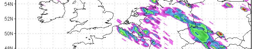

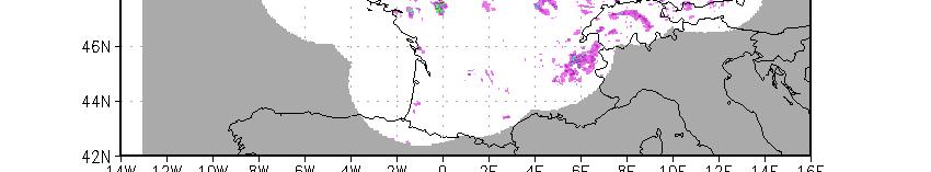
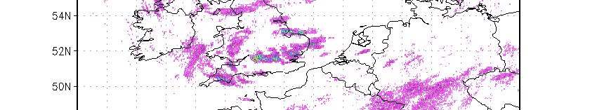
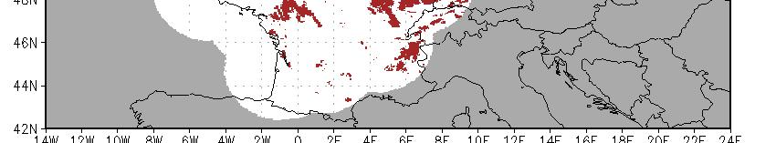
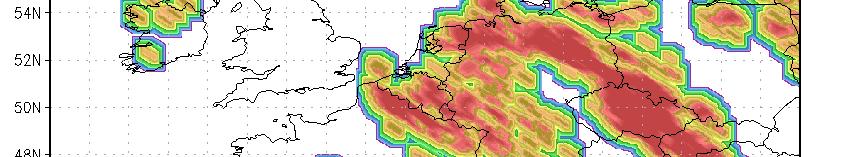
11 Rainfall Potential Examples Radar Rainfall Potential ti 11
12 Probability of Rainfall Algorithm Description Inputs» Rainfall Potential algorithm output (3-h total)» Intermediate (every 15 min) rainfall nowcasts from the Rainfall Potential algorithm. Calibrated using conditional probability tables» Rainfall Potential 1 mm: total number of raining 15-min periods» Rainfall Potential <1 mm: distance to nearest raining pixel Calibrated against the Rainfall Rate product» Eliminate uncertainties associated with Rainfall Rate errors;» Allow much more spatially widespread calibration (ground truth is generally available over Western Europe only) 12
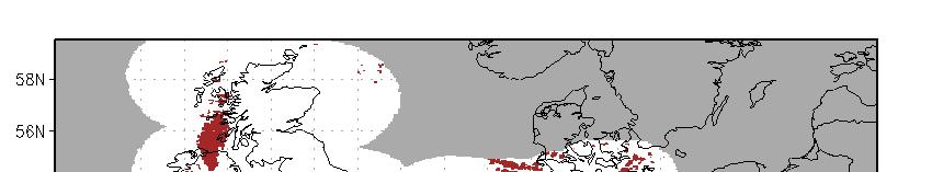
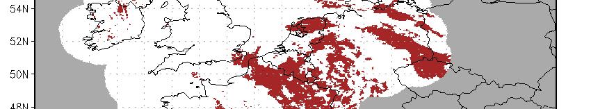
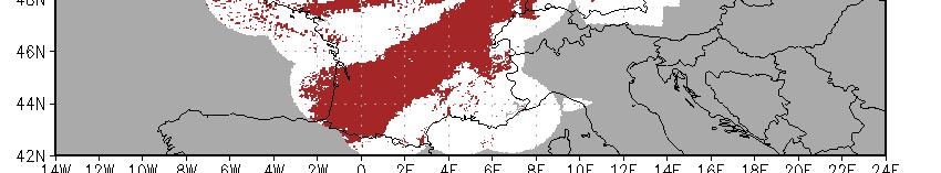
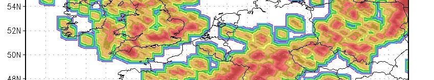
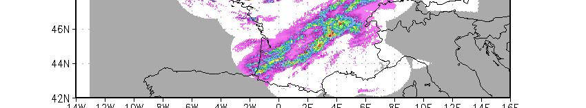
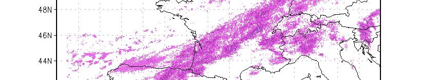
13 Probability of Rainfall Examples Radar Probability of frainfall 13


14 Validation: Truth Data Time scales 3 h, so must validate against radar Validation datasets in SEVIRI region: Tropical Rainfall Measuring Mission (TRMM) Precipitation Radar for Rainfall Rate Nimrod radar data from the British Atmospheric Data Centre (BADC) for all 3 algorithms 14


15 Rainfall Rate Fuzzy Validation Pixel-by-pixel comparisons difficult» Instantaneous rain rate varies too much at small scales Neighborhood comparison» Compare to most similar nearby value (Ebert 2008)» Better indication of usefulness» Not needed for 3-h Rainfall Potential / Probability 15 15
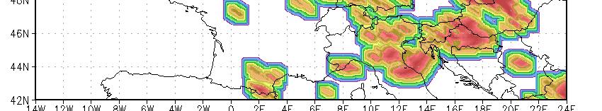
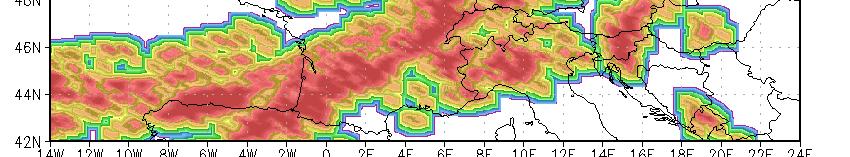
16 Rainfall Rate Validation Comparison with collocated TRMM PR for 6-9 January, April, July, and October 2005 and all of January


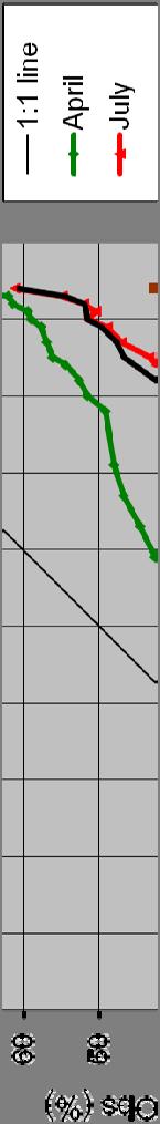
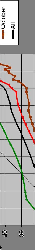
17 Rainfall Rate Validation CDF of (absolute) errors of Rainfall Rate pixels with rates of mm/h vs. TRMM PR for 51 days: 6-9 January, April, July, and October CDF of (absolute) errors of Rainfall Rate pixels with rates of mm/h vs. NIMROD radar data for 34 days: 6-9 April, July, and October
18 Rainfall Potential Validation Comparison with collocated Nimrod radar for 6-9 April, July, and October


19 Probability of Rainfall Validation Reliability diagram of Probability of Rainfall vs. Nimrod radar data for 5-9 April, July, and October

 Requirement vs.")

 Rainfall Potential")


20 Validation Summary vs. Spec Validation versus TRMM PR for 51 days of data: 6-9 January, April, July, and October 2005 and all of January 2008: Rainfall Rate (mm/h) Requirement vs. TRMM radar Accuracy Precision Accuracy Precision Validation against Nimrod for 6-9 April, July, and October 2005: Rainfall Rate (mm/h) Rainfall Potential (mm/3h) Requirement vs. NIMROD Accuracy Precision Accuracy Precision Requirement Evaluation Accuracy Precision Accuracy Precision (mm/3h) Probability of Rainfall (%) Requirement Evaluation Accuracy Precision Accuracy Precision
21 Status and Future Work Rainfall Rate:» Delivered final algorithm to System Prime 30 Sep 2011» Validation against an additional 4 months of data ongoing» Developing real-time and deep-dive dive validation tools for further evaluation and potential improvement» Maintenance delivery 30 September 2012 that incorporates feedback from deep-dive validation Rainfall Potential:» Optimizing parameters; final internal delivery May 2011» Final algorithm delivery to System Prime by 30 Sep 2011 Probability of Rainfall:» Continuing to recalibrate; final internal delivery May 2011» Final algorithm delivery to System Prime by 30 Sep
 Performance:» Rainfall Rate and Rainfall Potential meet GOES-R spec» Probability of Rainfall")

22 Summary Three rainfall-related algorithms for GOES-R:» Rainfall Rate» Rainfall Potential (0-3 h)» Probability of Rainfall (0-3 h) Performance:» Rainfall Rate and Rainfall Potential meet GOES-R spec» Probability of Rainfall partially meets spec and is being recalibrated Future Work:» Rainfall Rate has been finalized and is in the validation stage» Rainfall Potential and Probability of Rainfall are still being modified; final delivery September

23 Questions? 23
Application of Himawari-8 AHI Data to the GOES-R Rainfall Rate Algorithm
 Application of Himawari-8 AHI Data to the GOES-R Rainfall Rate Algorithm Yaping Li 1, Robert Kuligowski 2 and Yan Hao 1 1. IMSG at NOAA/NESDIS/STAR 2. NOAA/NESDIS/STAR, College Park, MD 1 GOES-R Baseline
H-SAF future developments on Convective Precipitation Retrieval
 H-SAF future developments on Convective Precipitation Retrieval Francesco Zauli 1, Daniele Biron 1, Davide Melfi 1, Antonio Vocino 1, Massimiliano Sist 2, Michele De Rosa 2, Matteo Picchiani 2, De Leonibus
Judit Kerényi. OMSZ-Hungarian Meteorological Service P.O.Box 38, H-1525, Budapest Hungary Abstract
 Comparison of the precipitation products of Hydrology SAF with the Convective Rainfall Rate of Nowcasting-SAF and the Multisensor Precipitation Estimate of EUMETSAT Judit Kerényi OMSZ-Hungarian Meteorological
The Status of NOAA/NESDIS Precipitation Algorithms and Products
 The Status of NOAA/NESDIS Precipitation Algorithms and Products Ralph Ferraro NOAA/NESDIS College Park, MD USA S. Boukabara, E. Ebert, K. Gopalan, J. Janowiak, S. Kidder, R. Kuligowski, H. Meng, M. Sapiano,
2009 Progress Report To The National Aeronautics and Space Administration NASA Energy and Water Cycle Study (NEWS) Program
 Program") 2009 Progress Report To The National Aeronautics and Space Administration NASA Energy and Water Cycle Study (NEWS) Program Proposal Title: Grant Number: PI: The Challenges of Utilizing Satellite Precipitation
2009 Progress Report To The National Aeronautics and Space Administration NASA Energy and Water Cycle Study (NEWS) Program Proposal Title: Grant Number: PI: The Challenges of Utilizing Satellite Precipitation
Status of the GeoKompsat-2A AMI rainfall rate algorithm
 Status of the GeoKompsat-2A AMI rainfall rate algorithm Dong-Bin Shin, Damwon So, Hyo-Jin Park Department of Atmospheric Sciences, Yonsei University Algorithm Strategy Well-known assumption in IR-based
Meteosat Third Generation (MTG): Lightning Imager and its products Jochen Grandell
: Lightning Imager and its products Jochen Grandell") 1 Go to View menu and click on Slide Master to update this footer. Include DM reference, version number and date Meteosat Third Generation (MTG): Lightning Imager and its products Jochen Grandell Topics
1 Go to View menu and click on Slide Master to update this footer. Include DM reference, version number and date Meteosat Third Generation (MTG): Lightning Imager and its products Jochen Grandell Topics
1. FY10 GOES-R3 Project Proposal Title Page
 1. FY10 GOES-R3 Project Proposal Title Page Title: Transitioning GOES-Based Nowcasting Capability into the GOES-R Era Project Type: Product development Proposal Status: Renewal Duration: 3 years FY08 -
GLM INR and Instrument Performance Evaluation
 GLM INR and Instrument Performance Evaluation Presented by Dennis Buechler University of Alabama in Huntsville Joint MTG LI Mission Advisory Group & GOES-R GLM Science Team Workshop, Rome Italy 27-29 May
Satellite derived precipitation estimates over Indian region during southwest monsoons
 J. Ind. Geophys. Union ( January 2013 ) Vol.17, No.1, pp. 65-74 Satellite derived precipitation estimates over Indian region during southwest monsoons Harvir Singh 1,* and O.P. Singh 2 1 National Centre
Remote Sensing of Precipitation
 Lecture Notes Prepared by Prof. J. Francis Spring 2003 Remote Sensing of Precipitation Primary reference: Chapter 9 of KVH I. Motivation -- why do we need to measure precipitation with remote sensing instruments?
Interpretation of Polar-orbiting Satellite Observations. Atmospheric Instrumentation
 Interpretation of Polar-orbiting Satellite Observations Outline Polar-Orbiting Observations: Review of Polar-Orbiting Satellite Systems Overview of Currently Active Satellites / Sensors Overview of Sensor
CHARACTERISATION OF STORM SEVERITY BY USE OF SELECTED CONVECTIVE CELL PARAMETERS DERIVED FROM SATELLITE DATA
 CHARACTERISATION OF STORM SEVERITY BY USE OF SELECTED CONVECTIVE CELL PARAMETERS DERIVED FROM SATELLITE DATA Piotr Struzik Institute of Meteorology and Water Management, Satellite Remote Sensing Centre
Global Instability Index: Product Guide
 Doc.No. Issue : : EUM/TSS/MAN/15/802106 v1c e-signed EUMETSAT Eumetsat-Allee 1, D-64295 Darmstadt, Germany Tel: +49 6151 807-7 Fax: +49 6151 807 555 Date : 2 September 2015 http://www.eumetsat.int WBS/DBS
MAIN ATTRIBUTES OF THE PRECIPITATION PRODUCTS DEVELOPED BY THE HYDROLOGY SAF PROJECT RESULTS OF THE VALIDATION IN HUNGARY
 MAIN ATTRIBUTES OF THE PRECIPITATION PRODUCTS DEVELOPED BY THE HYDROLOGY SAF PROJECT RESULTS OF THE VALIDATION IN HUNGARY Eszter Lábó OMSZ-Hungarian Meteorological Service, Budapest, Hungary labo.e@met.hu
Atmospheric Motion Vectors: Product Guide
 Atmospheric Motion Vectors: Product Guide Doc.No. Issue : : EUM/TSS/MAN/14/786435 v1a EUMETSAT Eumetsat-Allee 1, D-64295 Darmstadt, Germany Tel: +49 6151 807-7 Fax: +49 6151 807 555 Date : 9 April 2015
A statistical approach for rainfall confidence estimation using MSG-SEVIRI observations
 A statistical approach for rainfall confidence estimation using MSG-SEVIRI observations Elisabetta Ricciardelli*, Filomena Romano*, Nico Cimini*, Frank Silvio Marzano, Vincenzo Cuomo* *Institute of Methodologies
P1.23 HISTOGRAM MATCHING OF ASMR-E AND TMI BRIGHTNESS TEMPERATURES
 P1.23 HISTOGRAM MATCHING OF ASMR-E AND TMI BRIGHTNESS TEMPERATURES Thomas A. Jones* and Daniel J. Cecil Department of Atmospheric Science University of Alabama in Huntsville Huntsville, AL 1. Introduction
An Algorithm to Identify and Track Objects on Spatial Grids
 An Algorithm to Identify and Track Objects on Spatial Grids VA L L I A P PA L A K S H M A N A N N AT I O N A L S E V E R E S T O R M S L A B O R AT O R Y / U N I V E R S I T Y O F O K L A H O M A S E P,
Usage of McIDAS V with GOES R AWG products
 McIDAS User Group Meeting, October 25-27, 2010, Madison, WI Usage of McIDAS V with GOES R AWG products William Straka III UW/CIMSS Madison, Wisconsin, USA With help from Tom Rink (CIMSS/), Tom Achtor (CIMSS/),
*Corresponding author address: Charles Barrere, Weather Decision Technologies, 1818 W Lindsey St, Norman, OK
 P13R.11 Hydrometeorological Decision Support System for the Lower Colorado River Authority *Charles A. Barrere, Jr. 1, Michael D. Eilts 1, and Beth Clarke 2 1 Weather Decision Technologies, Inc. Norman,
Evaluation of Satellite Precipitation Products over the Central of Vietnam
 Evaluation of Satellite Precipitation Products over the Central of Vietnam Long Trinh-Tuan (1), Jun Matsumoto (1,2), Thanh Ngo-Duc (3) (1) Department of Geography, Tokyo Metropolitan University, Japan.
Generating precipitation ensembles from satellite observations: reproducing intermittency
 18 May 2016 Workshop on Stochastic Weather Generators Generating precipitation ensembles from satellite observations: reproducing intermittency Clément Guilloteau¹, Rémy Roca1, Marielle Gosset2 1 LEGOS,
Lecture 4b: Meteorological Satellites and Instruments. Acknowledgement: Dr. S. Kidder at Colorado State Univ.
 Lecture 4b: Meteorological Satellites and Instruments Acknowledgement: Dr. S. Kidder at Colorado State Univ. US Geostationary satellites - GOES (Geostationary Operational Environmental Satellites) US
and hydrological applications
 Overview of QPE/QPF techniques and hydrological applications Siriluk Chumchean Department of Civil Engineering Mahanakorn University of Technology Typhoon Committee Roving Seminar 2011, Malaysia (20-23
Judit Kerényi. OMSZ - Hungarian Meteorological Service, Budapest, Hungary. H-1525 Budapest, P.O.Box 38, Hungary.
 SATELLITE-DERIVED PRECIPITATION ESTIMATIONS DEVELOPED BY THE HYDROLOGY SAF PROJECT CASE STUDIES FOR THE INVESTIGATION OF THEIR ACCURACY AND FEATURES IN HUNGARY Judit Kerényi OMSZ - Hungarian Meteorological
Lecture 19: Operational Remote Sensing in Visible, IR, and Microwave Channels
 MET 4994 Remote Sensing: Radar and Satellite Meteorology MET 5994 Remote Sensing in Meteorology Lecture 19: Operational Remote Sensing in Visible, IR, and Microwave Channels Before you use data from any
IPWG s Potential Role in a Snow Hydrology Mission
 IPWG s Potential Role in a Snow Hydrology Mission Chris Kidd The University of Birmingham Birmingham, United Kingdom International Precipitation Working Group Ralph Ferraro NOAA/NESDIS College Park, MD
Demonstration in Lyon of real time integrated monitoring system supporting improved rainfall monitoring
 Demonstration in Lyon of real time integrated monitoring system supporting improved rainfall monitoring Demonstration in Lyon of real time integrated monitoring system supporting improved rainfall monitoring
Status report on current and future satellite systems by EUMETSAT Presented to CGMS-44, Plenary session, agenda item D.1
 Status report on current and future satellite systems by EUMETSAT Presented to CGMS-44, Plenary session, agenda item D.1 CGMS-44-EUMETSAT-WP-19.ppt, version 1 (# 859110), 8 June 2016 MISSION PLANNING YEAR...
ATMOSPHERIC MOTION VECTORS DERIVED FROM MSG RAPID SCANNING SERVICE DATA AT EUMETSAT
 ATMOSPHERIC MOTION VECTORS DERIVED FROM MSG RAPID SCANNING SERVICE DATA AT EUMETSAT Manuel Carranza 1, Arthur de Smet 2, Jörgen Gustafsson 2 1 GMV Aerospace and Defence S.A. at EUMETSAT, Eumetsat-Allee
The Australian Operational Daily Rain Gauge Analysis
 The Australian Operational Daily Rain Gauge Analysis Beth Ebert and Gary Weymouth Bureau of Meteorology Research Centre, Melbourne, Australia e.ebert@bom.gov.au Daily rainfall data and analysis procedure
3R.1 USING GROUND CLUTTER TO ADJUST RELATIVE RADAR CALIBRATION AT KWAJALEIN, RMI
 3R.1 USING GROUND CLUTTER TO ADJUST RELATIVE RADAR CALIBRATION AT KWAJALEIN, RMI David S. Silberstein 1,2,*, D. B. Wolff 1,3, D. A. Marks 1,2, and J. L. Pippitt 1,2 1 NASA Goddard Space Flight Center,
A MODEL IN SPATIAL AND TEMPORAL DOMAIN TO PREDICT RADAR RAINFALL DATA
 A MODEL IN SPATIAL AND TEMPORAL DOMAIN TO PREDICT RADAR RAINFALL DATA Nazario D. Ramirez-Beltran, Luz Torres Molina, Joan M. Castro, Sandra Cruz-Pol, José G. Colom-Ustáriz and Nathan Hosanna PRYSIG 2014
INTERPRETATION OF MSG IMAGES, PRODUCTS AND SAFNWC OUTPUTS FOR DUTY FORECASTERS
 INTERPRETATION OF MSG IMAGES, PRODUCTS AND SAFNWC OUTPUTS FOR DUTY FORECASTERS M. Putsay, M. Rajnai, M. Diószeghy, J. Kerényi, I.G. Szenyán and S. Kertész Hungarian Meteorological Service, H-1525 Budapest,
EUMETSAT products and services for monitoring storms - New missions, more data and more meteorological products
 EUMETSAT products and services for monitoring storms - New missions, more data and more meteorological products Jochen Grandell 1 EUM/RSP/VWG/17/921460 Outline Overview of EUMETSAT missions Current...and
Improving real time observation and nowcasting RDT. E de Coning, M Gijben, B Maseko and L van Hemert Nowcasting and Very Short Range Forecasting
 Improving real time observation and nowcasting RDT E de Coning, M Gijben, B Maseko and L van Hemert Nowcasting and Very Short Range Forecasting Introduction Satellite Application Facilities (SAFs) are
Snowfall Detection and Rate Retrieval from ATMS
 Snowfall Detection and Rate Retrieval from ATMS Jun Dong 1, Huan Meng 2, Cezar Kongoli 1, Ralph Ferraro 2, Banghua Yan 2, Nai-Yu Wang 1, Bradley Zavodsky 3 1 University of Maryland/ESSIC/Cooperative Institute
Welcome and Introduction
 Welcome and Introduction Riko Oki Earth Observation Research Center (EORC) Japan Aerospace Exploration Agency (JAXA) 7th Workshop of International Precipitation Working Group 17 November 2014 Tsukuba International
Operational quantitative precipitation estimation using radar, gauge g and
 Operational quantitative precipitation estimation using radar, gauge g and satellite for hydrometeorological applications in Southern Brazil Leonardo Calvetti¹, Cesar Beneti¹, Diogo Stringari¹, i¹ Alex
EUMETSAT Hydrological SAF H05 product development at CNMCA
 EUMETSAT Conference 2013 Session 3 - Quantitative applications for nowcasting Poster Presentation EUMETSAT Hydrological SAF H05 product development at CNMCA Antonio Vocino, Valentina Scappiti, Daniele
NEW SCHEME TO IMPROVE THE DETECTION OF RAINY CLOUDS IN PUERTO RICO
 NEW SCHEME TO IMPROVE THE DETECTION OF RAINY CLOUDS IN PUERTO RICO Joan Manuel Castro Sánchez Advisor Dr. Nazario Ramirez UPRM NOAA CREST PRYSIG 2016 October 7, 2016 Introduction A cloud rainfall event
Remote sensing of precipitation extremes
 The panel is about: Understanding and predicting weather and climate extreme Remote sensing of precipitation extremes Climate extreme : (JSC meeting, June 30 2014) IPCC SREX report (2012): Climate Ali
Global Satellite Products & Services for Agricultural and Vegetation Health
 Global Satellite Products & Services for Agricultural and Vegetation Health Presented at the WMO Expert Meeting on National Early Warning System for Agricultural Weather Management George Mason University
Comparison of TRMM LIS and PR with ground based lightning and radar observations for the TROCCINOX/ TroCCiBras/HIBISCUS field campaign
 Comparison of TRMM LIS and PR with ground based lightning and radar observations for the TROCCINOX/ TroCCiBras/HIBISCUS field campaign Thorsten Fehr, IPA/DLR, Germany Gerhard Held, IPMet/UNESP, Brazil
Description of the case study
 Description of the case study During the night and early morning of the 14 th of July 011 the significant cloud layer expanding in the West of the country and slowly moving East produced precipitation
STATUS AND DEVELOPMENT OF OPERATIONAL METEOSAT WIND PRODUCTS. Mikael Rattenborg. EUMETSAT, Am Kavalleriesand 31, D Darmstadt, Germany ABSTRACT
 STATUS AND DEVELOPMENT OF OPERATIONAL METEOSAT WIND PRODUCTS Mikael Rattenborg EUMETSAT, Am Kavalleriesand 31, D-64295 Darmstadt, Germany ABSTRACT The Operational Meteosat Meteorological Products are produced
Astronaut Ellison Shoji Onizuka Memorial Downtown Los Angeles, CA. Los Angeles City Hall
 Astronaut Ellison Shoji Onizuka Memorial Downtown Los Angeles, CA Los Angeles City Hall Passive Microwave Radiometric Observations over Land The performance of physically based precipitation retrievals
McIDAS Activities Within The NASA Langley Research Center Clouds And Radiation Group
 McIDAS Activities Within The NASA Langley Research Center Clouds And Radiation Group Kristopher Bedka Science Systems and Applications Inc @ NASA LaRC In Collaboration With (in alphabetical order) J. K.
A Time Lag Model to Estimate Rainfall Rate Based on GOES Data
 A Time Lag Model to Estimate Rainfall Rate Based on GOES Data Nazario D. Ramirez, Robert J. Kuligowski, and Joan M. Castro Octava Reunión Nacional de Percepción Remota y Sistemas Geográficos de Información
Observations of Mediterranean Precipitating Systems using AMSU
 Observations of Mediterranean Precipitating Systems using AMSU Beatriz FUNATSU 1, Chantal CLAUD 1 and Jean-Pierre CHABOUREAU 2 1 Laboratoire de Meteorologie Dynamique/IPSL, Palaiseau 2 Laboratoire d Aerologie/CNRS-UPS,
for the Global Precipitation Mission
 A Physically based Rainfall Rate Algorithm for the Global Precipitation Mission Kevin Garrett 1, Leslie Moy 1, Flavio Iturbide Sanchez 1, and Sid Ahmed Boukabara 2 5 th IPWG Workshop Hamburg, Germany October
Recent progress in convective scale Arome NWP system and on-going research activities
 Recent progress in convective scale Arome NWP system and on-going research activities P. Brousseau, P. Chambon, G. Faure, R. Honnert, A. Mary, N. Merlet, Y. Seity, B. Vié, E. Wattrelot (presented by F.
McIDAS support of Suomi-NPP /JPSS and GOES-R L2
 McIDAS support of Suomi-NPP /JPSS and GOES-R L2 William Straka III 1 Tommy Jasmin 1, Bob Carp 1 1 Cooperative Institute for Meteorological Satellite Studies, Space Science and Engineering Center, University
Real-Time Meteorological Gridded Data: What s New With HEC-RAS
 Real-Time Meteorological Gridded Data: What s New With HEC-RAS Acquisition and Application of Gridded Meteorological Data in Support of the USACE s Real-Time Water Management Mission Fauwaz Hanbali, Tom
"Cloud and Rainfall Observations using Microwave Radiometer Data and A-priori Constraints" Christian Kummerow and Fang Wang Colorado State University
 "Cloud and Rainfall Observations using Microwave Radiometer Data and A-priori Constraints" Christian Kummerow and Fang Wang Colorado State University ECMWF-JCSDA Workshop Reading, England June 16-18, 2010
URSI-F Microwave Signatures Meeting 2010, Florence, Italy, October 4 8, Thomas Meissner Lucrezia Ricciardulli Frank Wentz
 URSI-F Microwave Signatures Meeting 2010, Florence, Italy, October 4 8, 2010 Wind Measurements from Active and Passive Microwave Sensors High Winds and Winds in Rain Thomas Meissner Lucrezia Ricciardulli
NOAA/NESDIS Tropical Web Page with LEO Satellite Products and Applications for Forecasters
 NOAA/NESDIS Tropical Web Page with LEO Satellite Products and Applications for Forecasters Sheldon Kusselson National Oceanic and Atmospheric Administration (NOAA) National Environmental Satellite Data
11D.6 DIURNAL CYCLE OF TROPICAL DEEP CONVECTION AND ANVIL CLOUDS: GLOBAL DISTRIBUTION USING 6 YEARS OF TRMM RADAR AND IR DATA
 11D.6 DIURNAL CYCLE OF TROPICAL DEEP CONVECTION AND ANVIL CLOUDS: GLOBAL DISTRIBUTION USING 6 YEARS OF TRMM RADAR AND IR DATA 1. INTRODUCTION Before the launch of the TRMM satellite in late 1997, most
THE EUMETSAT MULTI-SENSOR PRECIPITATION ESTIMATE (MPE)
") THE EUMETSAT MULTI-SENSOR PRECIPITATION ESTIMATE (MPE) Thomas Heinemann, Alessio Lattanzio and Fausto Roveda EUMETSAT Am Kavalleriesand 31, 64295 Darmstadt, Germany ABSTRACT The combination of measurements
THE EUMETSAT MULTI-SENSOR PRECIPITATION ESTIMATE (MPE) Thomas Heinemann, Alessio Lattanzio and Fausto Roveda EUMETSAT Am Kavalleriesand 31, 64295 Darmstadt, Germany ABSTRACT The combination of measurements
Study on the rainfall dependence structure using radar and rain gauge data
 International Workshop Advances in Statistical hydrology, May 23-25 2010, Taormina, Italy Study on the rainfall dependence structure using radar and rain gauge data V. Montesarchio, F. Russo, F. Napolitano
Validation Report for Precipitation products from Cloud Physical Properties (PPh-PGE14: PCPh v1.0 & CRPh v1.0)
") Page: 1/26 Validation Report for Precipitation SAF/NWC/CDOP2/INM/SCI/VR/15, Issue 1, Rev. 0 15 July 2013 Applicable to SAFNWC/MSG version 2013 Prepared by AEMET Page: 2/26 REPORT SIGNATURE TABLE Function
Page: 1/26 Validation Report for Precipitation SAF/NWC/CDOP2/INM/SCI/VR/15, Issue 1, Rev. 0 15 July 2013 Applicable to SAFNWC/MSG version 2013 Prepared by AEMET Page: 2/26 REPORT SIGNATURE TABLE Function
Introducing Atmospheric Motion Vectors Derived from the GOES-16 Advanced Baseline Imager (ABI)
") Introducing Atmospheric Motion Vectors Derived from the GOES-16 Advanced Baseline Imager (ABI) Jaime Daniels NOAA/NESDIS, Center for Satellite Applications and Research Wayne Bresky, Andrew Bailey, Americo
Introducing Atmospheric Motion Vectors Derived from the GOES-16 Advanced Baseline Imager (ABI) Jaime Daniels NOAA/NESDIS, Center for Satellite Applications and Research Wayne Bresky, Andrew Bailey, Americo
APPENDIX 2 OVERVIEW OF THE GLOBAL PRECIPITATION MEASUREMENT (GPM) AND THE TROPICAL RAINFALL MEASURING MISSION (TRMM) 2-1
 AND THE TROPICAL RAINFALL MEASURING MISSION (TRMM) 2-1") APPENDIX 2 OVERVIEW OF THE GLOBAL PRECIPITATION MEASUREMENT (GPM) AND THE TROPICAL RAINFALL MEASURING MISSION (TRMM) 2-1 1. Introduction Precipitation is one of most important environmental parameters.
APPENDIX 2 OVERVIEW OF THE GLOBAL PRECIPITATION MEASUREMENT (GPM) AND THE TROPICAL RAINFALL MEASURING MISSION (TRMM) 2-1 1. Introduction Precipitation is one of most important environmental parameters.
VWG.01 EUMETSAT Corporate Slide Collection (EUM/CIS/VWG/14/743878) Version 1, January 2014 MONITORING WEATHER AND CLIMATE FROM SPACE
 Version 1, January 2014 MONITORING WEATHER AND CLIMATE FROM SPACE") 1 VWG.01 EUMETSAT Corporate Slide Collection (EUM/CIS/VWG/14/743878) Version 1, January 2014 MONITORING WEATHER AND CLIMATE FROM SPACE Royal charter: 25/26 October 1859 From observation to decision making:
1 VWG.01 EUMETSAT Corporate Slide Collection (EUM/CIS/VWG/14/743878) Version 1, January 2014 MONITORING WEATHER AND CLIMATE FROM SPACE Royal charter: 25/26 October 1859 From observation to decision making:
Operational Use of Scatterometer Winds in the JMA Data Assimilation System
 Operational Use of Scatterometer Winds in the Data Assimilation System Masaya Takahashi Numerical Prediction Division, Japan Meteorological Agency () International Ocean Vector Winds Science Team Meeting,
Operational Uses of Bands on the GOES-R Advanced Baseline Imager (ABI) Presented by: Kaba Bah
 Presented by: Kaba Bah") Operational Uses of Bands on the GOES-R Advanced Baseline Imager (ABI) Presented by: Kaba Bah Topics: Introduction to GOES-R & ABI ABI individual bands Use of band differences ABI derived products Conclusions
Operational Uses of Bands on the GOES-R Advanced Baseline Imager (ABI) Presented by: Kaba Bah Topics: Introduction to GOES-R & ABI ABI individual bands Use of band differences ABI derived products Conclusions
FUTURE PLAN AND RECENT ACTIVITIES FOR THE JAPANESE FOLLOW-ON GEOSTATIONARY METEOROLOGICAL SATELLITE HIMAWARI-8/9
 FUTURE PLAN AND RECENT ACTIVITIES FOR THE JAPANESE FOLLOW-ON GEOSTATIONARY METEOROLOGICAL SATELLITE HIMAWARI-8/9 Toshiyuki Kurino Japan Meteorological Agency, 1-3-4 Otemachi Chiyodaku, Tokyo 100-8122,
GOES-R R AWG Land Team: Green Vegetation Fraction (GVF)
") GOES-R R AWG Land Team: Green Vegetation Fraction (GVF) Presented by Peter Romanov Task Lead CICS University of Maryland, College Park 1 Land-GVF Team Peter Romanov, CICS/UMD (Product lead) Felix Kogan,
GOES-R R AWG Land Team: Green Vegetation Fraction (GVF) Presented by Peter Romanov Task Lead CICS University of Maryland, College Park 1 Land-GVF Team Peter Romanov, CICS/UMD (Product lead) Felix Kogan,
GENERATION OF HIMAWARI-8 AMVs USING THE FUTURE MTG AMV PROCESSOR
 GENERATION OF HIMAWARI-8 AMVs USING THE FUTURE MTG AMV PROCESSOR Manuel Carranza 1, Régis Borde 2, Masahiro Hayashi 3 1 GMV Aerospace and Defence S.A. at EUMETSAT, Eumetsat Allee 1, D-64295 Darmstadt,
Nowcasting of Severe Weather from Satellite Images (for Southern
 Nowcasting of Severe Weather from Satellite Images (for Southern Europe) Petra Mikuš Jurković Forecasting/ nowcasting of convective storms NWP models cannot well predict the exact location and intesity
Feature-specific verification of ensemble forecasts
 Feature-specific verification of ensemble forecasts www.cawcr.gov.au Beth Ebert CAWCR Weather & Environmental Prediction Group Uncertainty information in forecasting For high impact events, forecasters
Pacific Storm Track at Different Horizontal Resolutions Snap-shot of Column Liquid Water Content
 Color Plates Pacific Storm Track at Different Horizontal Resolutions Snap-shot of Column Liquid Water Content Fig. 2.8 A snapshot of the cyclone frontal-system by a nonhydrostatic model run with two very
Intermittency in precipitation: duration, frequency, intensity and amounts using hourly data
 Intermittency in precipitation: duration, frequency, intensity and amounts using hourly data Kevin E Trenberth with Yongxin Zhang and Maria Gehne NCAR How should rainfall change as climate changes? Usually
Rainfall estimation over the Taiwan Island from TRMM/TMI data
 P1.19 Rainfall estimation over the Taiwan Island from TRMM/TMI data Wann-Jin Chen 1, Ming-Da Tsai 1, Gin-Rong Liu 2, Jen-Chi Hu 1 and Mau-Hsing Chang 1 1 Dept. of Applied Physics, Chung Cheng Institute
Research Working Group Recommendations and Action Items
 Research Working Group Recommendations and Action Items IPWG 2016, Bologna, Italy, Oct. 6 th 2016. Chair: Ali Behrangi Rapporteur: Yeji Choi Participants 2016: R. Adler, M. Buiat., C. Funk, C. Guilloteau,
GOES-R. Getting ready for the next generation earth observing system. Yuguang He AER April 10, 2015
 GOES-R Getting ready for the next generation earth observing system Yuguang He AER April 10, 2015 Outline! AER in research and applica0ons! AER on GOES- R! GOES- R: the next genera0on! Ge:ng ready for
Ground-based Validation of spaceborne lidar measurements
 Ground-based Validation of spaceborne lidar measurements Ground-based Validation of spaceborne lidar measurements to make something officially acceptable or approved, to prove that something is correct
Transition from GVAR to GOES-R GRB Service Continuity
 Transition from GVAR to GOES-R GRB Service Continuity Presented to CGMS-43 Plenary session, agenda item F.2.3 CGMS-43-NOAA-WP-02 GOES-R at Test Location First 12 Months CGMS-43-NOAA-WP-02 Slide: 2 Transitioning
REPORT ON THE ACTIVITIES OF THE EUMETSAT-ESSL CONVECTION WORKING GROUP
 REPORT ON THE ACTIVITIES OF THE EUMETSAT-ESSL CONVECTION WORKING GROUP Marianne König EUMETSAT, Eumetsat Allee 1, 64295 Darmstadt, Germany Abstract The focus of the Convection Working Group is to have
Satellite-based Convection Nowcasting and Aviation Turbulence Applications
 Satellite-based Convection Nowcasting and Aviation Turbulence Applications Kristopher Bedka Cooperative Institute for Meteorological Satellite Studies (CIMSS), University of Wisconsin-Madison In collaboration
PRECIPITATION ESTIMATION FROM INFRARED SATELLITE IMAGERY
 PRECIPITATION ESTIMATION FROM INFRARED SATELLITE IMAGERY A.M. BRASJEN AUGUST 2014 1 2 PRECIPITATION ESTIMATION FROM INFRARED SATELLITE IMAGERY MASTER S THESIS AUGUST 2014 A.M. BRASJEN Department of Geoscience
Megha-Tropiques Mission Status. N. Viltard and the MT science team
 Megha-Tropiques Mission Status N. Viltard and the MT science team The Megha-Tropiques mission SCARAB BROADBAND VIRS MADRAS PMR IMAGER SAPHIR 183 GHz WV Sounder + GPS-ROSA Courtesy CNES Mission status update
On the Satellite Determination of Multilayered Multiphase Cloud Properties. Science Systems and Applications, Inc., Hampton, Virginia 2
 JP1.10 On the Satellite Determination of Multilayered Multiphase Cloud Properties Fu-Lung Chang 1 *, Patrick Minnis 2, Sunny Sun-Mack 1, Louis Nguyen 1, Yan Chen 2 1 Science Systems and Applications, Inc.,
Retrieval of precipitation from Meteosat-SEVIRI geostationary satellite observations
 Retrieval of precipitation from Meteosat-SEVIRI geostationary satellite observations Jan Fokke Meirink, Hidde Leijnse (KNMI) Rob Roebeling (EUMETSAT) Overview Introduction Algorithm description Validation
PARCWAPT Passive Radiometry Cloud Water Profiling Technique
 PARCWAPT Passive Radiometry Cloud Water Profiling Technique By: H. Czekala, T. Rose, Radiometer Physics GmbH, Germany A new cloud liquid water profiling technique by Radiometer Physics GmbH (patent pending)
Convection Nowcasting Products Available at the Army Test and Evaluation Command (ATEC) Ranges
 Ranges") Convection Nowcasting Products Available at the Army Test and Evaluation Command (ATEC) Ranges Cathy Kessinger National Center for Atmospheric Research (NCAR), Boulder, CO with contributions from: Wiebke
Convection Nowcasting Products Available at the Army Test and Evaluation Command (ATEC) Ranges Cathy Kessinger National Center for Atmospheric Research (NCAR), Boulder, CO with contributions from: Wiebke
MSG system over view
 MSG system over view 1 Introduction METEOSAT SECOND GENERATION Overview 2 MSG Missions and Services 3 The SEVIRI Instrument 4 The MSG Ground Segment 5 SAF Network 6 Conclusions METEOSAT SECOND GENERATION
The Global Precipitation Climatology Project (GPCP) CDR AT NOAA: Research to Real-time Climate Monitoring
 CDR AT NOAA: Research to Real-time Climate Monitoring") The Global Precipitation Climatology Project (GPCP) CDR AT NOAA: Research to Real-time Climate Monitoring Robert Adler, Matt Sapiano, Guojun Gu University of Maryland Pingping Xie (NCEP/CPC), George Huffman
The Global Precipitation Climatology Project (GPCP) CDR AT NOAA: Research to Real-time Climate Monitoring Robert Adler, Matt Sapiano, Guojun Gu University of Maryland Pingping Xie (NCEP/CPC), George Huffman
Cloud Top Height Product: Product Guide
 Cloud Top Height Product: Product Guide Doc.No. : Issue : v1c e-signed Date : 26 April 2017 WBS : EUM/TSS/MAN/14/786420 EUMETSAT Eumetsat-Allee 1, D-64295 Darmstadt, Germany Tel: +49 6151 807-7 Fax: +49
ECMWF. ECMWF Land Surface Analysis: Current status and developments. P. de Rosnay M. Drusch, K. Scipal, D. Vasiljevic G. Balsamo, J.
 Land Surface Analysis: Current status and developments P. de Rosnay M. Drusch, K. Scipal, D. Vasiljevic G. Balsamo, J. Muñoz Sabater 2 nd Workshop on Remote Sensing and Modeling of Surface Properties,
On the use of radar rainfall estimates and nowcasts in an operational heavy rainfall warning service
 On the use of radar rainfall estimates and nowcasts in an operational heavy rainfall warning service Alan Seed, Ross Bunn, Aurora Bell Bureau of Meteorology Australia The Centre for Australian Weather
OPERA: Operational Programme for the Exchange of Weather Radar Information
 OPERA: Operational Programme for the Exchange of Weather Radar Information ALADIN-HIRLAM workshop, Toulouse Maud Martet 26-28 April 2016 OPERA: An EUMETNET Project EUMETNET: EIG of 31 European National
Update on IPWG Activities
 Update on IPWG Activities Paul Kucera National Center for Atmospheric Research Research Applications Laboratory Boulder, Colorado, USA Bozena Lapeta Satellite Remote Sensing Centre Institute of Meteorology
THE CHARACTERISTICS OF DROP SIZE DISTRIBUTIONS AND CLASSIFICATIONS OF CLOUD TYPES USING GUDUCK WEATHER RADAR, BUSAN, KOREA
 THE CHARACTERISTICS OF DROP SIZE DISTRIBUTIONS AND CLASSIFICATIONS OF CLOUD TYPES USING GUDUCK WEATHER RADAR, BUSAN, KOREA Dong-In Lee 1, Min Jang 1, Cheol-Hwan You 2, Byung-Sun Kim 2, Jae-Chul Nam 3 Dept.
The Rainfall System Classification over the Korean Peninsula Using TRMM TMI and Ground Measurement Data
 6 th International Precipitation Working Group Workshop-São José dos Campos- October 15~19, 2012 The Rainfall System Classification over the Korean Peninsula Using TRMM TMI and Ground Measurement Data
VIIRS SDR Cal/Val: S-NPP Update and JPSS-1 Preparations
 VIIRS SDR Cal/Val: S-NPP Update and JPSS-1 Preparations VIIRS SDR Cal/Val Posters: Xi Shao Zhuo Wang Slawomir Blonski ESSIC/CICS, University of Maryland, College Park NOAA/NESDIS/STAR Affiliate Spectral
Ensuring Water in a Changing World
 Ensuring Water in a Changing World Evaluation and application of satellite-based precipitation measurements for hydro-climate studies over mountainous regions: case studies from the Tibetan Plateau Soroosh
Precipitation Estimation from Remotely Sensed Imagery Using an Artificial Neural Network Cloud Classification System
 1834 JOURNAL OF APPLIED METEOROLOGY Precipitation Estimation from Remotely Sensed Imagery Using an Artificial Neural Network Cloud Classification System YANG HONG Department of Hydrology and Water Resources,
Cloud Top Height Product: Product Guide
 Cloud Top Height Product: Product Guide Doc.No. Issue : : EUM/TSS/MAN/14/786420 v1a EUMETSAT Eumetsat-Allee 1, D-64295 Darmstadt, Germany Tel: +49 6151 807-7 Fax: +49 6151 807 555 Date : 21 August 2015