Transition from GVAR to GOES-R GRB Service Continuity
|
|
|
- Joan Welch
- 6 years ago
- Views:
Transcription
1 Transition from GVAR to GOES-R GRB Service Continuity Presented to CGMS-43 Plenary session, agenda item F.2.3 CGMS-43-NOAA-WP-02

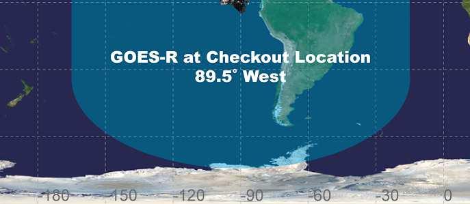
2 GOES-R at Test Location First 12 Months CGMS-43-NOAA-WP-02 Slide: 2
3 Transitioning from GOES-13/14/15 to GOES-R Improved data products for hemispheric retransmission GOES Rebroadcast (GRB) Faster full disk images 5 minutes (Mode 4) and 15 minutes (Mode 3) Full set of Level 1b data Data from six GOES-R instruments including all ABI channels Requires new antenna, receiver hardware, and processing system to handle the new data volumes Receiver frequency shift from MHz to MHz Dual circular polarized signals Going from 2.11 Mbps (GVAR) to 31 Mbps (GRB) CGMS-43-NOAA-WP-02 Slide: 3
4 Transition from GVAR to GRB GOES Variable (GVAR) GOES Rebroadcast (GRB) Full Disk Image 30 Minutes 5 Minutes (Mode 4) 15 min (Mode 3) Other Modes Rapid Scan, Super Rapid Scan 3000 km X 5000 km (CONUS: 5 minute) 1000 km X 1000 km (Mesoscale: 30 seconds) Polarization None Dual Circular Polarized Receiver Center Frequency MHz (L-Band) Data Rate 2.11 Mbps 31 Mbps MHz (L-Band) Antenna Coverage Earth Coverage to 5 0 Earth Coverage to 5 0 Data Sources Imager and Sounder ABI (16 bands), GLM, SEISS, EXIS, SUVI, MAG Space Weather None ~2 Mbps Lightning Data None 0.5 Mbps CGMS-43-NOAA-WP-02 Slide: 4


5 GRB Ground Antenna Sizes GOES-West GOES-East NOTES: 1. Calculations based on available data as of May Each antenna size is usable within the indicated contour 3. Rain attenuations included are: 1.3/1.6/2.0/2.2/2.5 db (3.8 to 6 m) 4. An operating margin of 2.5 db is included as the dual polarization isolation is likely to vary within each antenna size area CGMS-43-NOAA-WP-02 Slide: 5
6 GOES-R Operational System Configuration CGMS-43-NOAA-WP-02 Slide: 6
7 GRB Resources and Documentation Community Satellite Processing Package (CSPP) GRB Prototype 0.1 Release Prototype release of the CSPP Geo GRB software that will allow Direct Broadcast users to process GOES Rebroadcast (GRB) data received on their antennas from the GOES-R satellite, after it is launched in The main functionality included in this release is to ingest a simulated GRB data stream, recover Advanced Baseline Imager (ABI) Level 1 and Geostationary Lightning Mapper (GLM) Level 2 data payloads, reconstruct the datasets, and write output to mission-standard NetCDF files. Optionally, quicklook images can be generated from the ABI radiances. Later releases will add support for recovering data from the remaining GOES-R instruments: SUVI, EXIS, MAG and SEISS. This software is supported on 64-bit Centos6-compatible Linux platforms. Publicly available for download (and free to use) at: CGMS-43-NOAA-WP-02 Slide: 7
8 GRB Resources for Users GRB Downlink Specification Document for Users Provides GOES Rebroadcast radio frequency downlink characteristics, to enable the user community to develop GRB receivers GOES-R Product Users Guide (PUG) Describes the format and content of GRB data CGMS-43-NOAA-WP-02 Slide: 8
9 Summary GRB allows real time distribution of all Level-1b GOES-R data products for direct read out users Direct Readout users need to upgrade their equipment for GOES-R Significant increase in data rate New data format GRB down link specifications and data format specifications have been published Updates to be posted on the GOES-R web site: CGMS-43-NOAA-WP-02 Slide: 9
10 Back-up Slides CGMS-43-NOAA-WP-02 Slide: 10

 for GRB")
11 GRB Resources and Documentation GRB Downlink Specification Product Users Guide (PUG) for GRB CGMS-43-NOAA-WP-02 Slide: 11
12 GRB Downlink Characteristics Input Center Frequency: MHz Content (specified for each of two polarization channels: LHCP, RHCP) L1b data, QC data and metadata: ABI, SUVI, EXIS, SEISS, MAG L2 data, QC data, metadata: GLM GRB Information Packets Data rate 31 Mbps maximum data rate 15.5 Mbps instantaneous maximum for each polarization channel Downlink link margin: 2.5 db Compression - Lossless compression required JPEG2000 (ABI, SUVI) and SZIP (GLM); EXIS, SEISS and MAG data will not be compressed Format Outer Frame Format: DVB-S2 Inner Frame Format: CCSDS Space Packet Coding BCH + LDPC (2/3) for 8-PSK and LDPC (9/10) for QPSK Modem Required C/No (db-hz): 78.6 Maximum Demodulator Required Eb/No (db) for 1x10⁻¹⁰ BER: 3.7 db (8 PSK); 3.9 db (QPSK) Minimum Antenna System G/T (db/k) : 15.2 db/k (at 5 0 Elevation) CGMS-43-NOAA-WP-02 Slide: 12
13 Details of the GRB Dual Polarized Signal LHCP: L1b products from ABI 0.64 um band and 6 IR bands (3.9, 6.185, 7.34, 11.2, 12.3, and 13.3 um) RHCP: L1b products from ABI bands 0.47, 0.865, 1.378, 1.61, 2.25, 6.95, 8.5, 9.6 and 10.35um, L2+ GLM, L1b SUVI, L1b EXIS, L1b SEISS, and L1b Magnetometer products Ensures load balanced utilization of the two circular polarizations, allowing users to receive all GRB products with a dual-polarized system (both LHCP and RHCP), and allowing users flexibility to receive GOES Imager legacy channels with a single polarized system (LHCP only). CGMS-43-NOAA-WP-02 Slide: 13
14 Details of the GRB Dual Polarized Signal Reception of the GRB data requires a fixed dish antenna Dual feed horns connected to 2 Low Noise Amplifiers (LNAs) The LNA outputs are connected to RF/IF down-converters RF/IF down-converters connected to DVB-S2 capable receivers The GRB downlink center frequency of MHz requires an antenna G/T of 15.2 db/k for worst-case locations. This equates to a 4.5 meter dish with a system noise temperature of 120K You will need a new receive system from antenna to computer CGMS-43-NOAA-WP-02 Slide: 14
15 GRB Channel Content Summary ABI SUVI GLM Other ABI L1b image Data (compressed) QC bits Metadata Space packet overhead SUVI L1b image Data (compressed) Metadata Space packet overhead L2 Lightning Events/ Flashes/ Groups (compressed) Metadata Space packet overhead L1b EXIS, MAG, SEISS science data Metadata Space packet overhead Note: This is a catalog of the contents and not a sequential organization of the stream Included in two 15.5 Mbps Bandwidth channels For each instrument: image data + metadata + CCSDS Space Packet overhead ABI has per pixel QC bits, coded separately ABI, SUVI, GLM compressed GRB Info packets via CCSDS File Delivery Protocol (CFDP) Channel synchronization and coding (link layer) for DVB-S2 Error correction (LDPC) Info Packets GRB Information Packets CFDP Overhead Space packet overhead Channel Synchronization and Coding Error Correction CGMS-43-NOAA-WP-02 Slide: 15
16 GRB Data Characteristics IPDU (32 Bytes) Each GRB data packet contains two data structures. IPDU header containing information extracted from the transfer frames CCSDS packet containing instrument or satellite data Each CCSDS packet has a unique application identifier (APID): CCSDS Packet APID Start (Hex) APID End(Hex) Instrument 000 0FF Reserved 100 1FF ABI GRB 200 2FF GLM GRB 300 3FF EXIS GRB 400 4FF SEISS GRB 500 5FF SUVI GRB 600 6FF Mag GRB Info GRB 711 7FF Reserved CGMS-43-NOAA-WP-02 Slide: 16
17 GRB CCSDS Packet Data Each packet is made up of four segments: 1. Primary Header Specified by CCSDS Separate products have their own APID 2. Secondary Header Always present in GRB Packets Conformant with CCSDS Secondary Header specification Contains Version Number and Packet Type Assembler ID identifies the uplink location of GRB Assembly generating the packet (WCDAS/RBU) Operational Environment identifies the Data Production Environment within the Ground System (OE, ITE, DE) 3. GRB Data Payload (Science Data) Contains the actual product data Imagery, Atomic Blobs, or GRB Info 4. CRC 32-bit Cyclic Redundancy Check (CRC) to assure packet was received correctly. GRB Data Packet CCSDS Structure Bits Field 3 Packet Protocol Version 1 Packet Type 1 Secondary Header Flag 11 APID 2 Sequence Flags 14 Packet Sequence Count 16 Packet Data Length 16 Days Since the Epoch 32 Milliseconds of the Day 3 GRB Version 5 GRB Packet Type 4 Assembler ID 4 Operational Environment GRB Data Payload 32 CRC CGMS-43-NOAA-WP-02 Slide: 17
18 GRB Data Extraction CGMS-43-NOAA-WP-02 Slide: 18
Presented to CGMS-44 WGI session, agenda item 3.2 CGMS-43-NOAA-WP-03
 NOAA Transition to New Direct Readout Systems for GOES-R Presented to CGMS-44 WGI session, agenda item 3.2 CGMS-43-NOAA-WP-03 Getting Ready for the GOES-R Series: Transitioning from GVAR to GRB CGMS-43-NOAA-WP-03
GOES-16 & GOES-S: Natalia Donoho. Preparing Users for New Generation Satellites. WMO IPET-SUP-4 Geneva, Switzerland 26 February, 2018
 GOES-16 & GOES-S: Preparing Users for New Generation Satellites Natalia Donoho Satellite Products and Services Division (NOAA/NESDIS) WMO IPET-SUP-4 Geneva, Switzerland 26 February, 2018 GOES-R series
CSPP Geo. CSPP/IMAPP Users Group Meeting 2015 Darmstadt, Germany 15 April 2015
 CSPP Geo Graeme Martin, Liam Gumley, Nick Bearson, Jessica Braun, Geoff Cureton, Ray Garcia, Tommy Jasmin, Scott Mindock, Kathy Strabala University of Wisconsin Madison, Space Science & Engineering Center
Preparing for NOAA s Next Generation GOES-R & JPSS
 Preparing for NOAA s Next Generation GOES-R & JPSS Mark Paese Deputy Assistant Administrator NOAA Environmental Satellite & Information Service (NESDIS) WMO Cg-17: Ensuring User Readiness for New Generation
GOES-R Instrument Status and Accommodations. Barbara Pfarr GOES-R Program Systems Engineering January 2010 AMS Conference
 GOES-R Instrument Status and Accommodations Barbara Pfarr GOES-R Program Systems Engineering January 2010 AMS Conference Agenda Instrument Developmental Status Significant Changes in the Last Year Introducing
WMO Coordination Group on Satellite Data Requirements for Region III and IV Sept 5-8, 2016 Willemstad, Curaçao
 WMO Coordination Group on Satellite Data Requirements for Region III and IV Sept 5-8, 2016 Willemstad, Curaçao 1. Current Satellite Reception 2. Preparation for Next-Gen GOES-R JPSS 3. Satellite Data Applications
Dissemination of global products from Metop
 Dissemination of global products from Metop Simon S. Elliott EUMETSAT Operations Department, Darmstadt, Germany Introduction From an early stage in the commissioning of Metop, EUMETSAT will distribute
McIDAS support of Suomi-NPP /JPSS and GOES-R L2
 McIDAS support of Suomi-NPP /JPSS and GOES-R L2 William Straka III 1 Tommy Jasmin 1, Bob Carp 1 1 Cooperative Institute for Meteorological Satellite Studies, Space Science and Engineering Center, University
REPORT ON EUMETCAST INCLUDING GEONETCAST
 Prepared by EUMETSAT Agenda Item: F.2 Discussed in Plenary REPORT ON EUMETCAST INCLUDING GEONETCAST This paper presents the actual status of the system architecture, data services supported, and registration
Dissemination of Global Products from EUMETSAT
 Dissemination of Global Products from EUMETSAT Simon Elliott EUMETSAT simon.elliott@eumetsat.int Beijing, 23 May - 1 June 2005 Slide 1 Overview NRT Replaced by EUMETCast What is EUMETCast? Which data sets
Direct Readout at the Meteorological Service of Canada
 Direct Readout at the Meteorological Service of Canada CSPP Users Meeting 2015 Darmstadt, Germany April 14-16, 2015 David Bradley Manager, Earth Observation and Geomatics Meteorological Service of Canada
NOAA Operational Satellites -Program Update-
 NOAA Operational Satellites -Program Update- (GOES-R Series, JPSS & COSMIC-2) Briefing to the Expert Team on Satellite Systems (ET-SAT-11) Geneva, 4-6 April 2017 Sid Ahmed Boukabara NOAA/NESDIS Center
32 ND SPACE SYMPOSIUM GEOSTATIONARY OPERATIONAL ENVIRONMENTAL SATELLITES R SERIES (GOES-R) OVERVIEW AND STATUS
 OVERVIEW AND STATUS") 32 ND SPACE SYMPOSIUM GEOSTATIONARY OPERATIONAL ENVIRONMENTAL SATELLITES R SERIES (GOES-R) OVERVIEW AND STATUS MICHAEL STRINGER NOAA/NESDIS/GOES-R, michael.stringer@noaa.gov GOES-R, Assistant System Program
32 ND SPACE SYMPOSIUM GEOSTATIONARY OPERATIONAL ENVIRONMENTAL SATELLITES R SERIES (GOES-R) OVERVIEW AND STATUS MICHAEL STRINGER NOAA/NESDIS/GOES-R, michael.stringer@noaa.gov GOES-R, Assistant System Program
NEW CGMS BASELINE FOR THE SPACE-BASED GOS. (Submitted by the WMO Secretariat) Summary and Purpose of Document
 Summary and Purpose of Document") WORLD METEOROLOGICAL ORGANIZATION COMMISSION FOR BASIC SYSTEMS OPEN PROGRAMME AREA GROUP ON INTEGRATED OBSERVING SYSTEMS EXPERT TEAM ON SATELLITE SYSTEMS ET-SAT-7/Inf. 2 (12.III.2012) ITEM: 8.1 SEVENTH
WORLD METEOROLOGICAL ORGANIZATION COMMISSION FOR BASIC SYSTEMS OPEN PROGRAMME AREA GROUP ON INTEGRATED OBSERVING SYSTEMS EXPERT TEAM ON SATELLITE SYSTEMS ET-SAT-7/Inf. 2 (12.III.2012) ITEM: 8.1 SEVENTH
Meteosat Third Generation (MTG): Lightning Imager and its products Jochen Grandell
: Lightning Imager and its products Jochen Grandell") 1 Go to View menu and click on Slide Master to update this footer. Include DM reference, version number and date Meteosat Third Generation (MTG): Lightning Imager and its products Jochen Grandell Topics
1 Go to View menu and click on Slide Master to update this footer. Include DM reference, version number and date Meteosat Third Generation (MTG): Lightning Imager and its products Jochen Grandell Topics
MSG system over view
 MSG system over view 1 Introduction METEOSAT SECOND GENERATION Overview 2 MSG Missions and Services 3 The SEVIRI Instrument 4 The MSG Ground Segment 5 SAF Network 6 Conclusions METEOSAT SECOND GENERATION
Operational Uses of Bands on the GOES-R Advanced Baseline Imager (ABI) Presented by: Kaba Bah
 Presented by: Kaba Bah") Operational Uses of Bands on the GOES-R Advanced Baseline Imager (ABI) Presented by: Kaba Bah Topics: Introduction to GOES-R & ABI ABI individual bands Use of band differences ABI derived products Conclusions
Operational Uses of Bands on the GOES-R Advanced Baseline Imager (ABI) Presented by: Kaba Bah Topics: Introduction to GOES-R & ABI ABI individual bands Use of band differences ABI derived products Conclusions
Preparation for Himawari 8
 Preparation for Himawari 8 Japan Meteorological Agency Meteorological Satellite Center Hidehiko MURATA ET SUP 8, WMO HQ, Geneva, 14 17 April 2014 1/18 Introduction Background The Japan Meteorological Agency
Himawari 8/9 data distribution/dissemination plan
 Himawari 8/9 data distribution/dissemination plan Japan Meteorological Agency (JMA) Hidehiko MURATA Himawari is the name of this flower in Japanese ET SUP 8, WMO HQ, Geneva, 14 17 April 2014 1 Outline
Future GOES (XGOHI, GOES-13/O/P, GOES-R+)
") Future GOES (XGOHI, GOES-13/O/P, GOES-R+) Timothy J. Schmit NOAA/NESDIS/Satellite Applications and Research Advanced Satellite Products Branch (ASPB) Madison, WI And many others MUG Meeting October 16,
Future GOES (XGOHI, GOES-13/O/P, GOES-R+) Timothy J. Schmit NOAA/NESDIS/Satellite Applications and Research Advanced Satellite Products Branch (ASPB) Madison, WI And many others MUG Meeting October 16,
GOES-R. Getting ready for the next generation earth observing system. Yuguang He AER April 10, 2015
 GOES-R Getting ready for the next generation earth observing system Yuguang He AER April 10, 2015 Outline! AER in research and applica0ons! AER on GOES- R! GOES- R: the next genera0on! Ge:ng ready for
Status and Plans of Next Generation Japanese Geostationary Meteorological Satellites Himawari 8/9
 Status and Plans of Next Generation Japanese Geostationary Meteorological Satellites Himawari 8/9 Masahiro Hayashi 1, Kotaro Bessho 1, and Tomoo Ohno 2 1: JMA/Meteorological Satellite Center (MSC) 2: JMA/Satellite
FUTURE PLAN AND RECENT ACTIVITIES FOR THE JAPANESE FOLLOW-ON GEOSTATIONARY METEOROLOGICAL SATELLITE HIMAWARI-8/9
 FUTURE PLAN AND RECENT ACTIVITIES FOR THE JAPANESE FOLLOW-ON GEOSTATIONARY METEOROLOGICAL SATELLITE HIMAWARI-8/9 Toshiyuki Kurino Japan Meteorological Agency, 1-3-4 Otemachi Chiyodaku, Tokyo 100-8122,
TD 18 Metop-A Direct Readout AHRPT Technical Description
 TD 18 Metop-A Direct Readout AHRPT Technical Description Doc.No. : Issue : v1f Date : 17 March 2009 EUMETSAT Am Kavalleriesand 31, D-64295 Darmstadt, Germany Tel: +49 6151 807-7 Fax: +49 6151 807 555 http://www.eumetsat.int
Cooperative Institute for Meteorological Satellite Studies University of Wisconsin - Madison
 1 Content Introduction Visualize Analyze Validate/ Deep-dive Summary 2 Introduction. McIDAS-V is a powerful and versatile visualization and data analysis software. It is Java based, open source and freely
OTSUKIMI Moon-sighting Satellite Kyushu Institute of Technology. 3 rd Mission Idea Contest UNISEC Global
 OTSUKIMI Moon-sighting Satellite Kyushu Institute of Technology 3 rd Mission Idea Contest UNISEC Global The Idea We want to take image for the moon phases as seen from Earth Why? Introduction 1.6 billion,23.4%
Status report on current and future satellite systems by EUMETSAT Presented to CGMS-44, Plenary session, agenda item D.1
 Status report on current and future satellite systems by EUMETSAT Presented to CGMS-44, Plenary session, agenda item D.1 CGMS-44-EUMETSAT-WP-19.ppt, version 1 (# 859110), 8 June 2016 MISSION PLANNING YEAR...
Plans for NOAA s GOES-R Series Satellites
 Plans for NOAA s GOES-R Series Satellites G. Dittberner, E. Miller, M. Madden, and B. Nelson NOAA Satellite and Information Service 1315 East West Highway, Silver Spring, MD 20910 ABSTRACT NOAA s next
WISE Science Data System Single Frame Position Reconstruction Peer Review: Introduction and Overview
 WISE Science Data System Single Frame Position Reconstruction Peer Review: Introduction and Overview R. Cutri and the WSDC Team @ IPAC 1 Review Panel Rachel Akeson (IPAC/MSC) Gene Kopan (IPAC retired)
EARS-ATMS, EARS-CrIS and EARS-VIIRS: Three New Regional Services
 EARS-, EARS- and EARS-VIIRS: Three New Regional Services Anders Meier Soerensen, Ester Rojo, Thomas Heinemann, Michele Burla, Susanne Dieterle EUMETSAT Monitoring weather and climate from space Meteosat-7
Improvement of Himawari-8 observation data quality
 Improvement of Himawari-8 observation data quality 3 July 2017 Meteorological Satellite Center Japan Meteorological Agency The Japan Meteorological Agency (JMA) plans to modify its Himawari-8 ground processing
The FY-3C evaluation project: microwave sounder calibration and direct broadcast experiences. Met Office, Exeter, UK 2 CMA/NMSC, Beijing, China
 The FY-3C evaluation project: microwave sounder calibration and direct broadcast experiences Nigel Atkinson 1, Qifeng Lu 2, Bill Bell 1, Fabien Carminati 1, Katie Lean 1,3, Niels Bormann 3 and Heather
STATUS OF JAPANESE METEOROLOGICAL SATELLITES AND RECENT ACTIVITIES OF MSC
 STATUS OF JAPANESE METEOROLOGICAL SATELLITES AND RECENT ACTIVITIES OF MSC Daisaku Uesawa Meteorological Satellite Center, Japan Meteorological Agency Abstract MTSAT-1R is the current operational Japanese
WISE Science Data System Frame Co-addition Peer Review: Introduction and Overview
 WISE Science Data System Frame Co-addition Peer Review: Introduction and Overview R. Cutri and the WSDC Team @ IPAC 1 Review Panel Sean Carey (IPAC/SSC) Nick Gautier (JPL/WISE Science Team) John Good (IPAC/IRSA)
CGMS Baseline In response to CGMS action/recommendation A45.01 HLPP reference: 1.1.8
 Prepared by WGIII Agenda Item: 7.1 Discussed in WGIII CGMS Baseline In response to CGMS action/recommendation A45.01 HLPP reference: 1.1.8 In CGMS-45, Working Group III agreed to hold a review of the CGMS
EUMETSAT products and services for monitoring storms - New missions, more data and more meteorological products
 EUMETSAT products and services for monitoring storms - New missions, more data and more meteorological products Jochen Grandell 1 EUM/RSP/VWG/17/921460 Outline Overview of EUMETSAT missions Current...and
Performance of dual-searcher mobiles in hotspot scenarios
 Performance of dual-searcher mobiles in hotspot scenarios 1. Introduction Third Generation Partnership Project (3GPP) High Speed Packet Access (HSPA) Release 8 specifications introduced the RRC signaling
MONITORING WEATHER AND CLIMATE FROM SPACE
 MONITORING WEATHER AND CLIMATE FROM SPACE EUMETSAT Report on New Services Anders Meier Soerensen New X/L-band antenna, Greenland Athens: New 3.0 m L/X-band antenna New 2.4 m L/Xband antenna Installations
Status of EUMETSAT Operational Services & EUMETCast Africa Dissemination Baseline Updates
 Status of EUMETSAT Operational Services & EUMETCast Africa Dissemination Baseline Updates Sally Wannop User Relations Manager 1 8th WMO RAIDEG meeting 1-2 November 2017 # 951881 Overview EUMETCast Overview
REPORT ON GEONETCAST In response to CGMS action/recommendation
 Prepared by EUMETSAT Agenda Item: G.2 Discussed in Plenary, WGI, WGII, WGIII, WGIV REPORT ON GEONETCAST In response to CGMS action/recommendation GEONETCast, which consists of a network of three dissemination
EUMETSAT PLANS. K. Dieter Klaes EUMETSAT Darmstadt, Germany
 EUMETSAT PLANS K. Dieter Klaes EUMETSAT Darmstadt, Germany 1. INTRODUCTION The European Organisation for the Exploitation of Meteorological Satellites (EUMETSAT), contributes to the World Weather Watch
Agenda Item 17.3 RANET
 Agenda Item 17.3 RANET RANET Report with a Short Term and Long Term Strategy 4 th SPREP PMC, Honiara, Solomon Islands H. Gingerlei Porter UH TASI Edward H. Young, Jr., RANET Pacific Communications Coordinator
ALGORITHM AND SOFTWARE DEVELOPMENT OF ATMOSPHERIC MOTION VECTOR (AMV) PRODUCTS FOR THE FUTURE GOES-R ADVANCED BASELINE IMAGER (ABI)
 PRODUCTS FOR THE FUTURE GOES-R ADVANCED BASELINE IMAGER (ABI)") ALGORITHM AND SOFTWARE DEVELOPMENT OF ATMOSPHERIC MOTION VECTOR (AMV) PRODUCTS FOR THE FUTURE GOES-R ADVANCED BASELINE IMAGER (ABI) Jaime Daniels 1, Chris Velden 2, Wayne Bresky 3, Iliana Genkova 2, and
ALGORITHM AND SOFTWARE DEVELOPMENT OF ATMOSPHERIC MOTION VECTOR (AMV) PRODUCTS FOR THE FUTURE GOES-R ADVANCED BASELINE IMAGER (ABI) Jaime Daniels 1, Chris Velden 2, Wayne Bresky 3, Iliana Genkova 2, and
The GOES-R Rainfall Rate, Rainfall Potential, and Probability of Rainfall Algorithms
 The GOES-R Rainfall Rate, Rainfall Potential, and Probability of Rainfall Algorithms Bob Kuligowski, NOAA/NESDIS/STAR Yaping Li, Zhihua Zhang, Richard Barnhill, I. M. Systems Group 5 th International Precipitation
Status report on the current and future satellite systems by CMA. Presented to CGMS46-CMA-WP-01, Plenary session, agenda item D.1
 Status report on the current and future satellite systems by CMA Presented to CGMS46-CMA-WP-01, Plenary session, agenda item D.1 Overview - Planning of CMA satellite systems FengYun Meteorological Satellites
CGMS Baseline. Sustained contributions to the Global Observing System. Endorsed by CGMS-46 in Bengaluru, June 2018
 CGMS Baseline Sustained contributions to the Global Observing System Best Practices for Achieving User Readiness for New Meteorological Satellites Endorsed by CGMS-46 in Bengaluru, June 2018 CGMS/DOC/18/1028862,
1. History and Current Status
 Contents 1. History and Current Status History and Mission Image acquisition and Dissemination Products 2. Future Plan Schedule Mission of Himawari 8/9 Development of Products Data Dissemination 0 1. History
GOES-R Overview and Status
 GOES-R Overview and Status Tom Renkevens NOAA s Satellite and Information Service McIDAS Users Group 2005 October 27, 2005 1 Outline Purpose GOES Background Requirements Instrument Summary Notional Architecture
EARS-NWC SERVICE: NRT NOWCASTING PRODUCTS ON EUMETCAST
 1 VWG.01 EUMETSAT Corporate Slide Collection (EUM/CIS/VWG/11/0124) Version 3B, January 2013 EARS-NWC SERVICE: NRT NOWCASTING PRODUCTS ON EUMETCAST Thomas Heinemann EUMETSAT Adam Dybbroe (SMHI) Michele
ABI and AIRS Retrievals in McIDAS-V
 ABI and AIRS Retrievals in McIDAS-V Kaba Bah Content Introduction to McIDAS V Introduction to GOES R ABI Visualize simulated ABI using McIDAS V Analyze simulated ABI using McIDAS V Introduction to AIRS
Orbit and Transmit Characteristics of the CloudSat Cloud Profiling Radar (CPR) JPL Document No. D-29695
 JPL Document No. D-29695") Orbit and Transmit Characteristics of the CloudSat Cloud Profiling Radar (CPR) JPL Document No. D-29695 Jet Propulsion Laboratory California Institute of Technology Pasadena, CA 91109 26 July 2004 Revised
Orbit and Transmit Characteristics of the CloudSat Cloud Profiling Radar (CPR) JPL Document No. D-29695 Jet Propulsion Laboratory California Institute of Technology Pasadena, CA 91109 26 July 2004 Revised
Overview on GK-2A Data and Products
 SCOPE-Nowcasting EP-1 Overview on GK-2A Data and Products Jae-Dong Jang NMSC Geo-KOMPSAT-2A, AMI Sector Satellite in Orbit Operator Location Launch date Environmental payload and status GEO-KOMPSAT-2A
NOAA Direct Broadcast Data Initiative to Meet NWP Latency Requirements
 Prepared by M. Goldberg Agenda Item: II/2 Discussed in WG-II NOAA Direct Broadcast Data Initiative to Meet NWP Latency Requirements Summary of the Working Paper Action 40.18: CGMS Agencies to support fast
The ABI (Advanced Baseline Imager) on the GOES-R series
 on the GOES-R series") The ABI (Advanced Baseline Imager) on the GOES-R series Timothy J. Schmit NOAA/NESDIS/Satellite Applications and Research Advanced Satellite Products Branch (ASPB) Kaba Bah, Mathew M. Gunshor, Jun Li,
The ABI (Advanced Baseline Imager) on the GOES-R series Timothy J. Schmit NOAA/NESDIS/Satellite Applications and Research Advanced Satellite Products Branch (ASPB) Kaba Bah, Mathew M. Gunshor, Jun Li,
Overview of Himawari-8/9
 Overview of Himawari-8/9 Toshiyuki SAKURAI Meteorological Satellite Center (MSC) Japan Meteorological Agency (JMA) EUMeTrain Event Week on MTG-I Satellite 2016 Session2 - Himawari-8 and Data Applications
Geostationary Operational Environmental Satellite- R Series (GOES-R) 2016
 2016") Student Works 12-14-2016 Geostationary Operational Environmental Satellite- R Series (GOES-R) 2016 Paige N. Dixon Embry-Riddle Aeronautical University Follow this and additional works at: https://commons.erau.edu/student-works
Student Works 12-14-2016 Geostationary Operational Environmental Satellite- R Series (GOES-R) 2016 Paige N. Dixon Embry-Riddle Aeronautical University Follow this and additional works at: https://commons.erau.edu/student-works
The Future of the USAP Antarctic Internet Data Distribution System
 The Future of the USAP Antarctic Internet Data Distribution System A discussion on LDM Efforts at ASC with Satellite Ground Stations update Andrew B. Archer Antarctic Support Contract Matthew A. Lazzara
Introduction of the Hyperspectral Environmental Suite (HES) on GOES-R and beyond
 on GOES-R and beyond") Introduction of the Hyperspectral Environmental Suite (HES) on GOES-R and beyond Timothy J. Schmit SaTellite Applications and Research (STAR) Advanced Satellite Products Team (ASPT) Presented by Jun Li
Introduction of the Hyperspectral Environmental Suite (HES) on GOES-R and beyond Timothy J. Schmit SaTellite Applications and Research (STAR) Advanced Satellite Products Team (ASPT) Presented by Jun Li
The GOES-R Series: The Nation s Next- Generation Geostationary Weather Satellites
 The GOES-R Series: The Nation s Next- Generation Geostationary Weather Satellites Greg Mandt GOES-R System Program Director 29th Annual Glen Gerberg Weather and Climate Summit January 22, 2016 Why GOES-R?
Wireless Internet Exercises
 Wireless Internet Exercises Prof. Alessandro Redondi 2018-05-28 1 WLAN 1.1 Exercise 1 A Wi-Fi network has the following features: Physical layer transmission rate: 54 Mbps MAC layer header: 28 bytes MAC
GSCB Workshop 2009: EUMETSAT Missions
 GSCB Workshop 2009: EUMETSAT Missions Dr. Harald Rothfuss, EUMETSAT. GSCB Workshop 2007, ESRIN, Frascati, 18-19 June 2009. Slide: 1 Introduction To EUMETSAT The European Organisation for the Exploitation
Cross-calibration of Geostationary Satellite Visible-channel Imagers Using the Moon as a Common Reference
 Cross-calibration of Geostationary Satellite Visible-channel Imagers Using the Moon as a Common Reference Thomas C. Stone U.S. Geological Survey, Flagstaff AZ, USA 27 30 August, 2012 Motivation The archives
McIDAS-X Software Development and Demonstration. PDA Animated Weather (PAW) Status by Russ Dengel. Dave Santek and Jay Heinzelman.
 Status by Russ Dengel. Dave Santek and Jay Heinzelman.") McIDAS-X Software Development and Demonstration Dave Santek and Jay Heinzelman 2 June 2009 PDA Animated Weather (PAW) Status by Russ Dengel Overview McIDAS-X 2008, 2009.1 McIDAS-XRD 2008, 2009.1 Software
McIDAS-X Software Development and Demonstration Dave Santek and Jay Heinzelman 2 June 2009 PDA Animated Weather (PAW) Status by Russ Dengel Overview McIDAS-X 2008, 2009.1 McIDAS-XRD 2008, 2009.1 Software
Added four (4) 8GB memory sticks. Wxnport1.db.erau.edu Added four (4) 4GB memory sticks o System memory increased to 24 gigabytes
 8GB memory sticks. Wxnport1.db.erau.edu Added four (4) 4GB memory sticks o System memory increased to 24 gigabytes") Infrastructure Enhancements to Support Educational Use of GOES-16 Christopher G. Herbster Robert E. Haley Meteorology Program Applied Aviation Sciences Embry-Riddle Aeronautical University Daytona Beach,
Infrastructure Enhancements to Support Educational Use of GOES-16 Christopher G. Herbster Robert E. Haley Meteorology Program Applied Aviation Sciences Embry-Riddle Aeronautical University Daytona Beach,
The NOAA/NESDIS/STAR IASI Near Real-Time Product Processing and Distribution System
 The NOAA/NESDIS/STAR Near Real-Time Product Processing and Distribution System W. Wolf 2, T. King 1, Z. Cheng 1, W. Zhou 1, H. Sun 1, P. Keehn 1, L. Zhou 1, C. Barnet 2, and M. Goldberg 2 1 QSS Group Inc,
Improved MU-MIMO Performance for Future Systems Using Differential Feedback
 Improved MU-MIMO Performance for Future 80. Systems Using Differential Feedback Ron Porat, Eric Ojard, Nihar Jindal, Matthew Fischer, Vinko Erceg Broadcom Corp. {rporat, eo, njindal, mfischer, verceg}@broadcom.com
Using OGC standards to improve the common
 Using OGC standards to improve the common operational picture Abstract A "Common Operational Picture", or a, is a single identical display of relevant operational information shared by many users. The
Advanced Infrared Sounding System for Future Geostationary Satellites
 Advanced Infrared Sounding System for Future Geostationary Satellites Timothy J. Schmit @, Jun Li # Hal Bloom &, James J. Gurka & Jaime Daniels @, Mitch Goldberg @ Steve Ackerman #, Paul Menzel #, and
Judit Kerényi. OMSZ - Hungarian Meteorological Service, Budapest, Hungary. H-1525 Budapest, P.O.Box 38, Hungary.
 SATELLITE-DERIVED PRECIPITATION ESTIMATIONS DEVELOPED BY THE HYDROLOGY SAF PROJECT CASE STUDIES FOR THE INVESTIGATION OF THEIR ACCURACY AND FEATURES IN HUNGARY Judit Kerényi OMSZ - Hungarian Meteorological
NOAA Direct Broadcast Real-Time Network Status
 NOAA Direct Broadcast Real-Time Network Status Liam Gumley (CIMSS/SSEC/UW-Madison) Mitch Goldberg (JPSS/NOAA) WMO DBNET Operators Meeting Sept 2016 Overview NOAA antennas for Honolulu, Madison, Miami,
Updates on CMA FENGYUN Meteorological Satellite Programs
 Updates on CMA FENGYUN Meteorological Satellite Programs Peng ZHANG National Satellite Meteorological Center, China Meteorological Administration (NSMC/CMA) 29 Nov. - 5 Dec. 2017, Darmstadt, Germany 1.
ArcGIS Data Models: Raster Data Models. Jason Willison, Simon Woo, Qian Liu (Team Raster, ESRI Software Products)
") ArcGIS Data Models: Raster Data Models Jason Willison, Simon Woo, Qian Liu (Team Raster, ESRI Software Products) Overview of Session Raster Data Model Context Example Raster Data Models Important Raster
ArcGIS Data Models: Raster Data Models Jason Willison, Simon Woo, Qian Liu (Team Raster, ESRI Software Products) Overview of Session Raster Data Model Context Example Raster Data Models Important Raster
GEO New Mission and Synergy Joo-Hyung Ryu
 GEO New Mission and Synergy Joo-Hyung Ryu Korea Ocean Satellite Center Korea Institute Ocean Sciences & Technology GEMS GOCI-II GOCI Development : KARI & KIOST Cooperation Development Payload system -
Mapper & De-Mapper System Document
 Mapper & De-Mapper System Document Mapper / De-Mapper Table of Contents. High Level System and Function Block. Mapper description 2. Demodulator Function block 2. Decoder block 2.. De-Mapper 2..2 Implementation
Integrating an physical layer simulator in NS-3
 Integrating an 802.11 physical layer simulator in NS-3 Stylianos Papanastasiou Signals and Systems stypap@chalmers.se Outline Motivation Planned activity The implementation Validation, tradeoffs Future
Updates on Chinese Meteorological Satellite Programs
 6 th Asia/Oceania Meteorological Satellite Users Conference Updates on Chinese Meteorological Satellite Programs Caiying Wei Deputy director-general of NSMC National Satellite Meteorological Center (NSMC)
MADIS Airlines for America Briefing
 MADIS Airlines for America Briefing Meteorological Assimilated Data Ingest System (MADIS) FPAW Briefing Steve Pritchett NWS Aircraft Based Observations Program Manager MADIS Defined MADIS is a meteorological
NPP ATMS Instrument On-orbit Performance
 NPP ATMS Instrument On-orbit Performance K. Anderson, L. Asai, J. Fuentes, N. George Northrop Grumman Electronic Systems ABSTRACT The first Advanced Technology Microwave Sounder (ATMS) was launched on
Meteorological Service of Canada Perspectives. WMO Coordination Group on Satellite Data Requirements for RAIII/IV
 Meteorological Service of Canada Perspectives presented to the WMO Coordination Group on Satellite Data Requirements for RAIII/IV David Bradley Meteorological Service of Canada Environment Canada April
NCS. New Control System for the 30m Telescope. TBD. 2005
 Title: NCS. New Control System for the 30m Telescope. TBD. 2005 Identifier - Master URL: http://www.iram.es/irames/documents/ncs30mtbdsummer2005 Revision: ncs30mtbdsummer2005, v1.5 Date: 2005-10-06 Expiration
Comparative Study of LEO, MEO & GEO Satellites
 Comparative Study of LEO, MEO & GEO Satellites Smridhi Malhotra, Vinesh Sangwan, Sarita Rani Department of ECE, Dronacharya College of engineering, Khentawas, Farrukhnagar, Gurgaon-123506, India Email:
Introducing Atmospheric Motion Vectors Derived from the GOES-16 Advanced Baseline Imager (ABI)
") Introducing Atmospheric Motion Vectors Derived from the GOES-16 Advanced Baseline Imager (ABI) Jaime Daniels NOAA/NESDIS, Center for Satellite Applications and Research Wayne Bresky, Andrew Bailey, Americo
Introducing Atmospheric Motion Vectors Derived from the GOES-16 Advanced Baseline Imager (ABI) Jaime Daniels NOAA/NESDIS, Center for Satellite Applications and Research Wayne Bresky, Andrew Bailey, Americo
Overlaying GRIB data over NOAA APT weather satellite images using OpenCPN
 Overlaying GRIB data over NOAA APT weather satellite images using OpenCPN I receive NOAA weather satellite images which are quite useful when used alone but with GRIB wind and rain data overlaid they can
A MEDIUM EARTH ORBIT CONTELLATION FOR POLAR WIND MEASUREMENTS
 A MEDIUM EARTH ORBIT CONTELLATION FOR POLAR WIND MEASUREMENTS Gerald J. Dittberner 1, Shyam N. Bajpai 1, Andrew J. Gerber, jr. 2, Richard Baron 2, Francois Rogez 2 1 U.S. National Oceanic and Atmospheric
Synthetic Weather Radar: Offshore Precipitation Capability
 Synthetic Weather Radar: Offshore Precipitation Capability Mark S. Veillette 5 December 2017 Sponsors: Randy Bass, FAA ANG-C6 and Rogan Flowers, FAA AJM-33 DISTRIBUTION STATEMENT A: Approved for public
Satellite communications and the environment of space. V 1.1 Swiss Space Summer Camp 2016 Images: NASA 1
 Satellite communications and the environment of space Swiss Space Summer Camp 2016 Images: NASA 1 Can you name these satellites? Sputnik The first man made satellite Launched in 1957 by The USSR Mass 84kg,
MONITORING WEATHER AND CLIMATE FROM SPACE
 1 EUM/TSS/VWG/15/801307, April 2015 MONITORING WEATHER AND CLIMATE FROM SPACE Evolution of the EUMETSAT Advanced Retransmission Service (EARS) Anders Soerensen EUMETSAT EUMETSAT Advanced Retransmission
Introducing Actions/Recommendations from CGMS to the 14th International Winds Workshop
 Introducing Actions/Recommendations from CGMS to the 14th International Winds Workshop Jaime Daniels (NOAA) CGMS Rapporteur for IWWG with IWWG co-chairs Regis Borde (EUMETSAT) Steve Wanzong (UW/CIMSS)
NSIDC Metrics Report. Lisa Booker February 9, 2012
 NSIDC Metrics Report Lisa Booker February 9, 2012 ACSI Scores 2011 ACSI survey summary Sent to 5458 users; increased number of users contacted NSIDC response rate was 10%, up 1% from last year. NSIDC Customer
Turbo Codes for xdsl modems
 Turbo Codes for xdsl modems Juan Alberto Torres, Ph. D. VOCAL Technologies, Ltd. (http://www.vocal.com) John James Audubon Parkway Buffalo, NY 14228, USA Phone: +1 716 688 4675 Fax: +1 716 639 0713 Email:
EARS: A user-driven Regional Data Service
 EARS: A user-driven Regional Data Service Thomas Heinemann, C. Cabanas, A. Meier-Sørensen, S. Elliott Additional Data Services EUMETSAT 1 EARS: A user-driven Regional Data Service, EUM/SEP/VWG/17/925280,
Satellite Position Determination of LEO Spacecraft
 Satellite Position Determination of LEO Spacecraft S.C.Rathnakara ISRO Satellite Centre 5 th September, 2007 International Committee on Global Navigation Satellite Systems(ICG) Things to follow Brief background
Preparation for FY-4A. (Submitted by Xiang Fang, CMA)
") WORLD METEOROLOGICAL ORGANIZATION COMMISSION FOR BASIC SYSTEMS OPEN PROGRAMME AREA GROUP ON INTEGRATED OBSERVING SYSTEMS EXPERT TEAM ON SATELLITE UTILIZATION AND PRODUCTS ET-SUP-8/Doc. 10.3 (2.IV.2014)
WORLD METEOROLOGICAL ORGANIZATION COMMISSION FOR BASIC SYSTEMS OPEN PROGRAMME AREA GROUP ON INTEGRATED OBSERVING SYSTEMS EXPERT TEAM ON SATELLITE UTILIZATION AND PRODUCTS ET-SUP-8/Doc. 10.3 (2.IV.2014)
Latest status and developments at IMD since CGMS-45
 Latest status and developments at IMD since CGMS-45 CGMS-46, Plenary session, agenda item IMD-ISRO-WP-01 Presenter: S K Peshin Report Prepared By: S K Peshin, Virendra Singh, A.K.Mitra Overview - Planning
Welcome to NR502 GIS Applications in Natural Resources. You can take this course for 1 or 2 credits. There is also an option for 3 credits.
 Welcome to NR502 GIS Applications in Natural Resources. You can take this course for 1 or 2 credits. There is also an option for 3 credits. The 1st credit consists of a series of readings, demonstration,
MSC HPC Infrastructure Update. Alain St-Denis Canadian Meteorological Centre Meteorological Service of Canada
 MSC HPC Infrastructure Update Alain St-Denis Canadian Meteorological Centre Meteorological Service of Canada Outline HPC Infrastructure Overview Supercomputer Configuration Scientific Direction 2 IT Infrastructure
Lightning Imaging Sensor (LIS) on ISS and Plans for Sustained Ground Measurements in Support of GLM Cal/Val
 on ISS and Plans for Sustained Ground Measurements in Support of GLM Cal/Val") Lightning Imaging Sensor (LIS) on ISS and Plans for Sustained Ground Measurements in Support of GLM Cal/Val Presented by Richard Blakeslee NASA/Marshall Space Flight Center Joint MTG LI Mission Advisory
Lightning Imaging Sensor (LIS) on ISS and Plans for Sustained Ground Measurements in Support of GLM Cal/Val Presented by Richard Blakeslee NASA/Marshall Space Flight Center Joint MTG LI Mission Advisory
A AVHRR NDVI dataset for Svalbard. Stian Solbø, Inge Lauknes, Cecilie Sneberg Grøtteland, Stine Skrunes, Hannah Vickers, Kjell Arild Høgda
 A 1986-2014 AVHRR NDVI dataset for Svalbard Stian Solbø, Inge Lauknes, Cecilie Sneberg Grøtteland, Stine Skrunes, Hannah Vickers, Kjell Arild Høgda AVHRR series of satellites/instruments Satellite name
Unidata Policy Committee NOAA/NWS Update
 Unidata Policy Committee NOAA/NWS Update October 27, 2011 LeRoy Spayd Chief Training Division Office of Climate, Water, and Weather Services NOAA s National Weather Service 1 2 Outline NOAA Budget NOAA
UPDATE ON RARS. Action/Recommendation proposed:
 Prepared by WMO Agenda Item: IV.4 Discussed in WG IV UPDATE ON RARS A brief report is provided on the global network of Regional ATOVS Retransmission Services (RARS). As of 1 October 2009, the global RARS