Cooperative Institute for Meteorological Satellite Studies University of Wisconsin - Madison
|
|
|
- Shannon Goodman
- 5 years ago
- Views:
Transcription


1 1
2 Content Introduction Visualize Analyze Validate/ Deep-dive Summary 2
3 Introduction. McIDAS-V is a powerful and versatile visualization and data analysis software. It is Java based, open source and freely available. WRF-Chem is the Weather Research and Forecasting (WRF) model coupled with Chemistry. Simulates the emission, transport, mixing, and chemical transformation of trace gases with the meteorology. 3

4 Visualiztion 4

5 Visualiztion 5
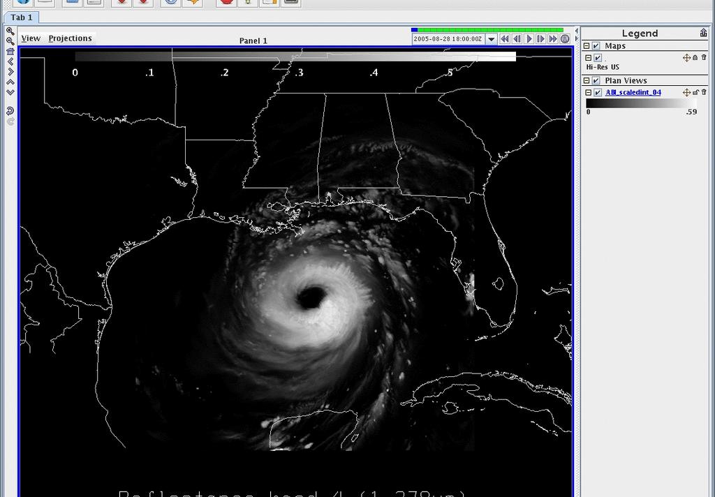
 and displayed in McIDAS-V for the June-26-2008 storm")
6 Full disk simulation of ABI band14 (11.2um) and displayed in McIDAS-V for the June storm outbreak at 21:00UTC. 6
7 Visualization 7
8 Visualiztion 8
9 Visualiztion Simultaneously (16 bands) Full disk (Big picture) Mesoscale (Focus) Loops (over time) 9
10 Analyze 10

11 Analyze Transact 11

12 Scatter analysis 12

13 Scripting for other displays 13
14 Once upon a time: Analyze: Tell a story There was a GOES East and GOES West. Both had only one water vapor band. We could see what had happened after it rains. It was exiting. Then we heard, GOES-R was coming With thee water vapor bands and 30 times better. We will see what is happening when it rains. Hmm.., Wait a minute, where was all this rain before? Now what are we going do if something happens? 14
15 Analyze: Tell a story 15
16 ABI- weighting functions The weighting functions were calculated using simulated spectral response functions based on proposed ABI bandwidths. 16

17 Analyze 1 17
18 Puzzle: 5 Analyze: 75W vs 89.5W 18

19 19

20 20

21 Sat. Sub point: 75W vs 89.5W 21
22 Analyze Data Transacts Scatter plots Google maps Tell a story Solve a puzzle 22
23 Validation and deep diving 23
24 Sub-sampling vs Averaging 24

25 Sub-sampling vs Averaging 25
26 Sanity check/navigation 26
27 AIRS DPI in AWIPS TO DO LIST. Remapping data for AWIPS. Stitch files together for each pass. Setup and test new files in McIDAS-V. Setup and test new files in AWIPS.
 ground coverage http://www.star.nesdis.noaa.")
28 The Atmospheric Infrared Sounder (AIRS) is a cross-track rotary scanning sensor with a ± 49.5 degrees (from nadir) ground coverage 28

29 Sanity check/navigation GOAL:Stitch AIRS files together for each pass Before and after 29

30 Stitching files together for each pass Before and after stitching files. Test 02

31 Setup and test new stitched files in McIDAS-V 31

32 Setup and test new stitched files in AWIPS 32
33 Detector Analysis HERE WE DIVE. 33

34 Detector Analysis 34
35 CONUS Simulation CONUS Simulation for 4 June 2005 Noise free from NWP Remapped to ABI Fixed Grid Format (FGF), nominally 2km CONUS sector is 2500 by 1500 pixels 3,750,000 total pixels 3,661,932 of these are on the Earth Deviation simulated by adding noise to the 12.3um band image for every 100 th line. Products besides Imagery are generated using first all noise-free data and comparing to those generated with all bands noise-free data except band 15 (12.3um) with striping 35
36 12.3um Band 15 Simulation 36

37 12.3um Band 15 Simulation with Striping 37

38 12.3um Band 15 Simulation with Striping Difference Image 38

39 12.3um Band 15 Simulation with Striping Difference Image 39

40 12.3um Band 15 Simulation 40
41 12.3um Band 15 Simulation with Striping 41
42 Imagery Analysis Based on image generation and viewing, it is thought that: The band 15 Imagery product is not affected significantly Users would not notice visible striping in the imagery without clean data for comparison A smart remapper could effectively mitigate this It is not worth affecting the other detector arrays for a problem this insignificant for one detector. Bottom line: Investigate a smarter resampler, but this particular issue is not a show stopper 42
43 Diving deep Sampling vs Averaging AIRS DPI navigation Detector Analysis 43
44 Summary Very interactive. Has something to offer for most. Easy to install easy to use Free, Free, free Now go get it.!! 44
45 END 45

46 QUESTIONS?? 46
ABI and AIRS Retrievals in McIDAS-V
 ABI and AIRS Retrievals in McIDAS-V Kaba Bah Content Introduction to McIDAS V Introduction to GOES R ABI Visualize simulated ABI using McIDAS V Analyze simulated ABI using McIDAS V Introduction to AIRS
Introducing Atmospheric Motion Vectors Derived from the GOES-16 Advanced Baseline Imager (ABI)
") Introducing Atmospheric Motion Vectors Derived from the GOES-16 Advanced Baseline Imager (ABI) Jaime Daniels NOAA/NESDIS, Center for Satellite Applications and Research Wayne Bresky, Andrew Bailey, Americo
Introducing Atmospheric Motion Vectors Derived from the GOES-16 Advanced Baseline Imager (ABI) Jaime Daniels NOAA/NESDIS, Center for Satellite Applications and Research Wayne Bresky, Andrew Bailey, Americo
CURRENT STATUS OF OPERATIONAL WIND PRODUCT IN JMA/MSC
 Proceedings for the 13 th International Winds Workshop 27 June - 1 July 2016, Monterey, California, USA CURRENT STATUS OF OPERATIONAL WIND PRODUCT IN JMA/MSC Kazuki Shimoji and Kenichi Nonaka JMA/MSC,
Introduction of the Hyperspectral Environmental Suite (HES) on GOES-R and beyond
 on GOES-R and beyond") Introduction of the Hyperspectral Environmental Suite (HES) on GOES-R and beyond Timothy J. Schmit SaTellite Applications and Research (STAR) Advanced Satellite Products Team (ASPT) Presented by Jun Li
Introduction of the Hyperspectral Environmental Suite (HES) on GOES-R and beyond Timothy J. Schmit SaTellite Applications and Research (STAR) Advanced Satellite Products Team (ASPT) Presented by Jun Li
Operational Uses of Bands on the GOES-R Advanced Baseline Imager (ABI) Presented by: Kaba Bah
 Presented by: Kaba Bah") Operational Uses of Bands on the GOES-R Advanced Baseline Imager (ABI) Presented by: Kaba Bah Topics: Introduction to GOES-R & ABI ABI individual bands Use of band differences ABI derived products Conclusions
Operational Uses of Bands on the GOES-R Advanced Baseline Imager (ABI) Presented by: Kaba Bah Topics: Introduction to GOES-R & ABI ABI individual bands Use of band differences ABI derived products Conclusions
McIDAS Activities Within The NASA Langley Research Center Clouds And Radiation Group
 McIDAS Activities Within The NASA Langley Research Center Clouds And Radiation Group Kristopher Bedka Science Systems and Applications Inc @ NASA LaRC In Collaboration With (in alphabetical order) J. K.
Preparation for Himawari 8
 Preparation for Himawari 8 Japan Meteorological Agency Meteorological Satellite Center Hidehiko MURATA ET SUP 8, WMO HQ, Geneva, 14 17 April 2014 1/18 Introduction Background The Japan Meteorological Agency
GIFTS- A SYSTEM FOR WIND PROFILING FROM GEOSTATIONARY SATELLITES
 GIFTS- A SYSTEM FOR WIND PROFILING FROM GEOSTATIONARY SATELLITES William Smith, Wallace Harrison, Dwayne Hinton, Vickie Parsons and Allen Larar NASA LaRC, Hampton Virginia (USA) Henry Revercomb 1, Allen
FUTURE PLAN AND RECENT ACTIVITIES FOR THE JAPANESE FOLLOW-ON GEOSTATIONARY METEOROLOGICAL SATELLITE HIMAWARI-8/9
 FUTURE PLAN AND RECENT ACTIVITIES FOR THE JAPANESE FOLLOW-ON GEOSTATIONARY METEOROLOGICAL SATELLITE HIMAWARI-8/9 Toshiyuki Kurino Japan Meteorological Agency, 1-3-4 Otemachi Chiyodaku, Tokyo 100-8122,
Improvement of Himawari-8 observation data quality
 Improvement of Himawari-8 observation data quality 3 July 2017 Meteorological Satellite Center Japan Meteorological Agency The Japan Meteorological Agency (JMA) plans to modify its Himawari-8 ground processing
Applications of future GEO advanced IR sounder for high impact weather forecasting demonstration with regional OSSE
 Applications of future GEO advanced IR sounder for high impact weather forecasting demonstration with regional OSSE Jun Li @, Tim Schmit &, Zhenglong Li @, Feng Zhu @*, Pei Wang @*, Agnes Lim @, and Robert
Weather Forecasting: Lecture 2
 Weather Forecasting: Lecture 2 Dr. Jeremy A. Gibbs Department of Atmospheric Sciences University of Utah Spring 2017 1 / 40 Overview 1 Forecasting Techniques 2 Forecast Tools 2 / 40 Forecasting Techniques
Lecture 4b: Meteorological Satellites and Instruments. Acknowledgement: Dr. S. Kidder at Colorado State Univ.
 Lecture 4b: Meteorological Satellites and Instruments Acknowledgement: Dr. S. Kidder at Colorado State Univ. US Geostationary satellites - GOES (Geostationary Operational Environmental Satellites) US
VALIDATION OF INSAT-3D DERIVED RAINFALL. (Submitted by Suman Goyal, IMD) Summary and Purpose of Document
 Summary and Purpose of Document") WORLD METEOROLOGICAL ORGANIZATION COMMISSION FOR BASIC SYSTEMS OPEN PROGRAMME AREA GROUP ON INTEGRATED OBSERVING SYSTEMS INTER-PROGRAMME EXPERT TEAM ON SATELLITE UTILIZATION AND PRODUCTS SECOND SESSION
WORLD METEOROLOGICAL ORGANIZATION COMMISSION FOR BASIC SYSTEMS OPEN PROGRAMME AREA GROUP ON INTEGRATED OBSERVING SYSTEMS INTER-PROGRAMME EXPERT TEAM ON SATELLITE UTILIZATION AND PRODUCTS SECOND SESSION
LARGE-SCALE WRF-SIMULATED PROXY ATMOSPHERIC PROFILE DATASETS USED TO SUPPORT GOES-R RESEARCH ACTIVITIES
 LARGE-SCALE WRF-SIMULATED PROXY ATMOSPHERIC PROFILE DATASETS USED TO SUPPORT GOES-R RESEARCH ACTIVITIES Jason Otkin, Hung-Lung Huang, Tom Greenwald, Erik Olson, and Justin Sieglaff Cooperative Institute
MSGVIEW: AN OPERATIONAL AND TRAINING TOOL TO PROCESS, ANALYZE AND VISUALIZATION OF MSG SEVIRI DATA
 MSGVIEW: AN OPERATIONAL AND TRAINING TOOL TO PROCESS, ANALYZE AND VISUALIZATION OF MSG SEVIRI DATA Aydın Gürol Ertürk Turkish State Meteorological Service, Remote Sensing Division, CC 401, Kalaba Ankara,
GEOMETRIC CLOUD HEIGHTS FROM METEOSAT AND AVHRR. G. Garrett Campbell 1 and Kenneth Holmlund 2
 GEOMETRIC CLOUD HEIGHTS FROM METEOSAT AND AVHRR G. Garrett Campbell 1 and Kenneth Holmlund 2 1 Cooperative Institute for Research in the Atmosphere Colorado State University 2 EUMETSAT ABSTRACT Geometric
Hyperspectral Microwave Atmospheric Sounding
 Hyperspectral Microwave Atmospheric Sounding W. J. Blackwell, L. J. Bickmeier, R. V. Leslie, M. L. Pieper, J. E. Samra, and C. Surussavadee 1 April 14, 2010 ITSC-17 This work is sponsored by the Department
Using the CRTM and GOES Observations to Improve Model Microphysics
 Using the CRTM and GOES Observations to Improve Model Microphysics Dan Lindsey NOAA Center for Satellite Applications and Research, CIRA, Ft. Collins, CO Louie Grasso, Yoo-Jeong Noh, Steve Miller, Curtis
Remote Sensing in Meteorology: Satellites and Radar. AT 351 Lab 10 April 2, Remote Sensing
 Remote Sensing in Meteorology: Satellites and Radar AT 351 Lab 10 April 2, 2008 Remote Sensing Remote sensing is gathering information about something without being in physical contact with it typically
Simulated MSG SEVIRI Imagery from HARMONIE-AROME
 Simulated MSG SEVIRI Imagery from HARMONIE-AROME Angeles Hernandez, AEMET Joint 28th ALADIN Workshop & HIRLAM All-Staff Meeting 2018 - Toulouse, 16-20 Apr 2018 Outline 1. Simulated Satellite Images (SSI)
Remote Sensing Seminar 8 June 2007 Benevento, Italy. Lab 5 SEVIRI and MODIS Clouds and Fires
 Remote Sensing Seminar 8 June 2007 Benevento, Italy Lab 5 SEVIRI and MODIS Clouds and Fires Table: SEVIRI Channel Number, Wavelength (µm), and Primary Application Reflective Bands 1,2 0.635, 0.81 land/cld
Using McIDAS-V for Satellite-Based Thunderstorm Research and Product Development
 Using McIDAS-V for Satellite-Based Thunderstorm Research and Product Development Kristopher Bedka UW-Madison, SSEC/CIMSS In Collaboration With: Tom Rink, Jessica Staude, Tom Whittaker, Wayne Feltz, and
GOES-R Advanced Baseline Imager (ABI) Algorithm Theoretical Basis Document For Derived Motion Winds
 Algorithm Theoretical Basis Document For Derived Motion Winds") NOAA NESDIS CENTER for SATELLITE APPLICATIONS and RESEARCH GOES-R Advanced Baseline Imager (ABI) Algorithm Theoretical Basis Document For Derived Motion Winds Jaime Daniels, NOAA/NESDIS/STAR Wayne Bresky,
NOAA NESDIS CENTER for SATELLITE APPLICATIONS and RESEARCH GOES-R Advanced Baseline Imager (ABI) Algorithm Theoretical Basis Document For Derived Motion Winds Jaime Daniels, NOAA/NESDIS/STAR Wayne Bresky,
F O U N D A T I O N A L C O U R S E
 F O U N D A T I O N A L C O U R S E December 6, 2018 Satellite Foundational Course for JPSS (SatFC-J) F O U N D A T I O N A L C O U R S E Introduction to Microwave Remote Sensing (with a focus on passive
Introduction of the Hyperspectral Environmental Suite (HES) on GOES-R and beyond
 on GOES-R and beyond") Introduction of the Hyperspectral Environmental Suite (HES) on GOES-R and beyond 1 Timothy J. Schmit, 2 Jun Li, 3 James Gurka 1 NOAA/NESDIS, Office of Research and Applications, Advanced Satellite Products
Introduction of the Hyperspectral Environmental Suite (HES) on GOES-R and beyond 1 Timothy J. Schmit, 2 Jun Li, 3 James Gurka 1 NOAA/NESDIS, Office of Research and Applications, Advanced Satellite Products
Transition from GVAR to GOES-R GRB Service Continuity
 Transition from GVAR to GOES-R GRB Service Continuity Presented to CGMS-43 Plenary session, agenda item F.2.3 CGMS-43-NOAA-WP-02 GOES-R at Test Location First 12 Months CGMS-43-NOAA-WP-02 Slide: 2 Transitioning
McIDAS support of Suomi-NPP /JPSS and GOES-R L2
 McIDAS support of Suomi-NPP /JPSS and GOES-R L2 William Straka III 1 Tommy Jasmin 1, Bob Carp 1 1 Cooperative Institute for Meteorological Satellite Studies, Space Science and Engineering Center, University
Utilising Radar and Satellite Based Nowcasting Tools for Aviation Purposes in South Africa. Erik Becker
 Utilising Radar and Satellite Based Nowcasting Tools for Aviation Purposes in South Africa Erik Becker Morné Gijben, Mary-Jane Bopape, Stephanie Landman South African Weather Service: Nowcasting and Very
The Value of Geostationary Satellite Imagery in IOOS, Now and Future
 The Value of Geostationary Satellite Imagery in IOOS, Now and Future A. S. Lomax Itri Corporation D. W. Colburn Lockheed Martin Civil Space M. K. Galbraith Itri Corporation Abstract- The United States
Added four (4) 8GB memory sticks. Wxnport1.db.erau.edu Added four (4) 4GB memory sticks o System memory increased to 24 gigabytes
 8GB memory sticks. Wxnport1.db.erau.edu Added four (4) 4GB memory sticks o System memory increased to 24 gigabytes") Infrastructure Enhancements to Support Educational Use of GOES-16 Christopher G. Herbster Robert E. Haley Meteorology Program Applied Aviation Sciences Embry-Riddle Aeronautical University Daytona Beach,
Infrastructure Enhancements to Support Educational Use of GOES-16 Christopher G. Herbster Robert E. Haley Meteorology Program Applied Aviation Sciences Embry-Riddle Aeronautical University Daytona Beach,
Preparing for NOAA s Next Generation GOES-R & JPSS
 Preparing for NOAA s Next Generation GOES-R & JPSS Mark Paese Deputy Assistant Administrator NOAA Environmental Satellite & Information Service (NESDIS) WMO Cg-17: Ensuring User Readiness for New Generation
Combining Polar Hyper-spectral and Geostationary Multi-spectral Sounding Data A Method to Optimize Sounding Spatial and Temporal Resolution
 Combining Polar Hyper-spectral and Geostationary Multi-spectral Sounding Data A Method to Optimize Sounding Spatial and Temporal Resolution W. L. Smith 1,2, E. Weisz 1, and J. McNabb 2 1 University of
P2.34 GEOLOCATION OF THE GEOSYNCHRONOUS IMAGING FOURIER TRANSFORM SPECTROMETER (GIFTS) DATA
 DATA") P2.34 GEOLOCATION OF THE GEOSYNCHRONOUS IMAGING FOURIER TRANSFORM SPECTROMETER (GIFTS) DATA Sanjay S. Limaye, Todd Smith, Robert O. Knuteson and Henry E. Revercomb University of Wisconsin-Madison, Madison,
P2.34 GEOLOCATION OF THE GEOSYNCHRONOUS IMAGING FOURIER TRANSFORM SPECTROMETER (GIFTS) DATA Sanjay S. Limaye, Todd Smith, Robert O. Knuteson and Henry E. Revercomb University of Wisconsin-Madison, Madison,
Assimilation of Satellite Infrared Brightness Temperatures and Doppler Radar Observations in a High-Resolution OSSE
 Assimilation of Satellite Infrared Brightness Temperatures and Doppler Radar Observations in a High-Resolution OSSE Jason Otkin and Becky Cintineo University of Wisconsin-Madison, Cooperative Institute
Future GOES (XGOHI, GOES-13/O/P, GOES-R+)
") Future GOES (XGOHI, GOES-13/O/P, GOES-R+) Timothy J. Schmit NOAA/NESDIS/Satellite Applications and Research Advanced Satellite Products Branch (ASPB) Madison, WI And many others MUG Meeting October 16,
Future GOES (XGOHI, GOES-13/O/P, GOES-R+) Timothy J. Schmit NOAA/NESDIS/Satellite Applications and Research Advanced Satellite Products Branch (ASPB) Madison, WI And many others MUG Meeting October 16,
Future Opportunities of Using Microwave Data from Small Satellites for Monitoring and Predicting Severe Storms
 Future Opportunities of Using Microwave Data from Small Satellites for Monitoring and Predicting Severe Storms Fuzhong Weng Environmental Model and Data Optima Inc., Laurel, MD 21 st International TOV
A New Numerical Weather Prediction Approach to the NDFD's Sky Cover Grid
 A New Numerical Weather Prediction Approach to the NDFD's Sky Cover Grid Jordan Gerth Graduate Research Assistant Cooperative Institute for Meteorological Satellite Studies (CIMSS) and Department of Atmospheric
Presented to CGMS-44 WGI session, agenda item 3.2 CGMS-43-NOAA-WP-03
 NOAA Transition to New Direct Readout Systems for GOES-R Presented to CGMS-44 WGI session, agenda item 3.2 CGMS-43-NOAA-WP-03 Getting Ready for the GOES-R Series: Transitioning from GVAR to GRB CGMS-43-NOAA-WP-03
Meteosat Third Generation (MTG): Lightning Imager and its products Jochen Grandell
: Lightning Imager and its products Jochen Grandell") 1 Go to View menu and click on Slide Master to update this footer. Include DM reference, version number and date Meteosat Third Generation (MTG): Lightning Imager and its products Jochen Grandell Topics
1 Go to View menu and click on Slide Master to update this footer. Include DM reference, version number and date Meteosat Third Generation (MTG): Lightning Imager and its products Jochen Grandell Topics
AOMSUC-6 Training Event
 Effective use of high temporal and spatial resolution Himawari-8 data AOMSUC-6 Training Event Bodo Zeschke Australian Bureau of Meteorology Training Centre Australian VLab Centre of Excellence Content
STATUS OF JAPANESE METEOROLOGICAL SATELLITES AND RECENT ACTIVITIES OF MSC
 STATUS OF JAPANESE METEOROLOGICAL SATELLITES AND RECENT ACTIVITIES OF MSC Daisaku Uesawa Meteorological Satellite Center, Japan Meteorological Agency Abstract MTSAT-1R is the current operational Japanese
IMPACT OF GROUND-BASED GPS PRECIPITABLE WATER VAPOR AND COSMIC GPS REFRACTIVITY PROFILE ON HURRICANE DEAN FORECAST. (a) (b) (c)
 (b) (c)") 9B.3 IMPACT OF GROUND-BASED GPS PRECIPITABLE WATER VAPOR AND COSMIC GPS REFRACTIVITY PROFILE ON HURRICANE DEAN FORECAST Tetsuya Iwabuchi *, J. J. Braun, and T. Van Hove UCAR, Boulder, Colorado 1. INTRODUCTION
9B.3 IMPACT OF GROUND-BASED GPS PRECIPITABLE WATER VAPOR AND COSMIC GPS REFRACTIVITY PROFILE ON HURRICANE DEAN FORECAST Tetsuya Iwabuchi *, J. J. Braun, and T. Van Hove UCAR, Boulder, Colorado 1. INTRODUCTION
A MEDIUM EARTH ORBIT CONTELLATION FOR POLAR WIND MEASUREMENTS
 A MEDIUM EARTH ORBIT CONTELLATION FOR POLAR WIND MEASUREMENTS Gerald J. Dittberner 1, Shyam N. Bajpai 1, Andrew J. Gerber, jr. 2, Richard Baron 2, Francois Rogez 2 1 U.S. National Oceanic and Atmospheric
McIDAS-X Software Development and Demonstration. PDA Animated Weather (PAW) Status by Russ Dengel. Dave Santek and Jay Heinzelman.
 Status by Russ Dengel. Dave Santek and Jay Heinzelman.") McIDAS-X Software Development and Demonstration Dave Santek and Jay Heinzelman 2 June 2009 PDA Animated Weather (PAW) Status by Russ Dengel Overview McIDAS-X 2008, 2009.1 McIDAS-XRD 2008, 2009.1 Software
McIDAS-X Software Development and Demonstration Dave Santek and Jay Heinzelman 2 June 2009 PDA Animated Weather (PAW) Status by Russ Dengel Overview McIDAS-X 2008, 2009.1 McIDAS-XRD 2008, 2009.1 Software
Severe storms over the Mediterranean Sea: A satellite and model analysis
 National Research Council of Italy Severe storms over the Mediterranean Sea: A satellite and model analysis V. Levizzani, S. Laviola, A. Malvaldi, M. M. Miglietta, and E. Cattani 6 th International Precipitation
Lecture 19: Operational Remote Sensing in Visible, IR, and Microwave Channels
 MET 4994 Remote Sensing: Radar and Satellite Meteorology MET 5994 Remote Sensing in Meteorology Lecture 19: Operational Remote Sensing in Visible, IR, and Microwave Channels Before you use data from any
SAN FRANCISCO STATE UNIVERSITY NAME DEPARTMENT OF GEOSCIENCES Spring 2013
 SAN FRANCISCO STATE UNIVERSITY NAME DEPARTMENT OF GEOSCIENCES Spring 2013 METR 415/715: MONTEVERDI QUIZ 1 Open Book and Open Notes 200 points, 45 minutes 1. Compute the altitude of a geostationary orbit
Hyperspectral IR clear and cloudy sounding retrieval study
 Hyperspectral IR clear and cloudy sounding retrieval study Jun Li @, Timothy J. Schmit #, Chian-Yi Liu @, Elisabeth Weisz @, Li Guan @, and Allen Huang @ @Cooperative Institute for Meteorological Satellite
Royal Netherlands Meteorological Institute Ministry of Infrastructure and the Environment
 Royal Netherlands Meteorological Institute Ministry of Infrastructure and the Environment 3D Exploration of Weather Data in Combination with IASI L2 Products for Better Understanding of Potential Applications
EUMETSAT products and services for monitoring storms - New missions, more data and more meteorological products
 EUMETSAT products and services for monitoring storms - New missions, more data and more meteorological products Jochen Grandell 1 EUM/RSP/VWG/17/921460 Outline Overview of EUMETSAT missions Current...and
Utilization of Forecast Models in High Temporal GOES Sounding Retrievals
 Utilization of Forecast Models in High Temporal GOES Sounding Retrievals Zhenglong Li, Jun Li, W. Paul Menzel, Steve Ackerman CIMSS/UW The CoRP Symposium Aug 12-13, 2008 Corvallis, OR Introduction: GOES
MSG system over view
 MSG system over view 1 Introduction METEOSAT SECOND GENERATION Overview 2 MSG Missions and Services 3 The SEVIRI Instrument 4 The MSG Ground Segment 5 SAF Network 6 Conclusions METEOSAT SECOND GENERATION
Satellite Imagery and Virtual Global Cloud Layer Simulation from NWP Model Fields
 Satellite Imagery and Virtual Global Cloud Layer Simulation from NWP Model Fields John F. Galantowicz John J. Holdzkom Thomas Nehrkorn Robert P. D Entremont Steve Lowe AER Atmospheric and Environmental
THE FEASIBILITY OF EXTRACTING LOWLEVEL WIND BY TRACING LOW LEVEL MOISTURE OBSERVED IN IR IMAGERY OVER CLOUD FREE OCEAN AREA IN THE TROPICS
 THE FEASIBILITY OF EXTRACTING LOWLEVEL WIND BY TRACING LOW LEVEL MOISTURE OBSERVED IN IR IMAGERY OVER CLOUD FREE OCEAN AREA IN THE TROPICS Toshiro Ihoue and Tetsuo Nakazawa Meteorological Research Institute
Impact of assimilating the VIIRS-based CrIS cloudcleared radiances on hurricane forecasts
 Impact of assimilating the VIIRS-based CrIS cloudcleared radiances on hurricane forecasts Jun Li @, Pei Wang @, Jinlong Li @, Zhenglong Li @, Jung-Rim Lee &, Agnes Lim @, Timothy J. Schmit #, and Mitch
The next-generation supercomputer and NWP system of the JMA
 The next-generation supercomputer and NWP system of the JMA Masami NARITA m_narita@naps.kishou.go.jp Numerical Prediction Division (NPD), Japan Meteorological Agency (JMA) Purpose of supercomputer & NWP
Development of 3D Variational Assimilation System for ATOVS Data in China
 Development of 3D Variational Assimilation System for ATOVS Data in China Xue Jishan, Zhang Hua, Zhu Guofu, Zhuang Shiyu 1) Zhang Wenjian, Liu Zhiquan, Wu Xuebao, Zhang Fenyin. 2) 1) Chinese Academy of
OBJECTIVE USE OF HIGH RESOLUTION WINDS PRODUCT FROM HRV MSG CHANNEL FOR NOWCASTING PURPOSES
 OBJECTIVE USE OF HIGH RESOLUTION WINDS PRODUCT FROM HRV MSG CHANNEL FOR NOWCASTING PURPOSES José Miguel Fernández Serdán, Javier García Pereda Servicio de Técnicas de Análisis y Predicción, Servicio de
Model Output Statistics (MOS)
") Model Output Statistics (MOS) Numerical Weather Prediction (NWP) models calculate the future state of the atmosphere at certain points of time (forecasts). The calculation of these forecasts is based on
Model Output Statistics (MOS) Numerical Weather Prediction (NWP) models calculate the future state of the atmosphere at certain points of time (forecasts). The calculation of these forecasts is based on
McMath-Pierce Adaptive Optics Overview. Christoph Keller National Solar Observatory, Tucson
 McMath-Pierce Adaptive Optics Overview Christoph Keller National Solar Observatory, Tucson Small-Scale Structures on the Sun 1 arcsec Important astrophysical scales (pressure scale height in photosphere,
ABB Remote Sensing Atmospheric Emitted Radiance Interferometer AERI system overview. Applications
 The ABB Atmospheric Emitted Radiance Interferometer AERI provides thermodynamic profiling, trace gas detection, atmospheric cloud aerosol study, air quality monitoring, and more. AERI high level overview
Development of physical retrieval algorithm for clear sky atmospheric profiles from SEVIRI, GOES Sounder and ABI infrared radiances
 Development of physical retrieval algorithm for clear sky atmospheric profiles from SEVIRI, GOES Sounder and ABI infrared radiances Jun Li Cooperative Institute for Meteorological Satellite Studies University
CMA Consideration on early-morning orbit satellite
 CMA Consideration on early-morning orbit satellite National Satellite Meteorological Center,CMA Yang Jun CGMS 40 in Lugano, 5-9 Nov., 2012 Outline Background Gap analysis on the sounding data coverage
OPERATIONAL USE OF METEOSAT-8 SEVIRI DATA AND DERIVED NOWCASTING PRODUCTS. Nataša Strelec Mahović
 OPERATIONAL USE OF METEOSAT-8 SEVIRI DATA AND DERIVED NOWCASTING PRODUCTS Nataša Strelec Mahović Meteorological and Hydrological Service Grič 3, 10 000 Zagreb, Croatia strelec@cirus.dhz.hr ABSTRACT Meteosat-8
ALGORITHM AND SOFTWARE DEVELOPMENT OF ATMOSPHERIC MOTION VECTOR (AMV) PRODUCTS FOR THE FUTURE GOES-R ADVANCED BASELINE IMAGER (ABI)
 PRODUCTS FOR THE FUTURE GOES-R ADVANCED BASELINE IMAGER (ABI)") ALGORITHM AND SOFTWARE DEVELOPMENT OF ATMOSPHERIC MOTION VECTOR (AMV) PRODUCTS FOR THE FUTURE GOES-R ADVANCED BASELINE IMAGER (ABI) Jaime Daniels 1, Chris Velden 2, Wayne Bresky 3, Iliana Genkova 2, and
ALGORITHM AND SOFTWARE DEVELOPMENT OF ATMOSPHERIC MOTION VECTOR (AMV) PRODUCTS FOR THE FUTURE GOES-R ADVANCED BASELINE IMAGER (ABI) Jaime Daniels 1, Chris Velden 2, Wayne Bresky 3, Iliana Genkova 2, and
Improving Tropical Cyclone Forecasts by Assimilating Microwave Sounder Cloud-Screened Radiances and GPM precipitation measurements
 Improving Tropical Cyclone Forecasts by Assimilating Microwave Sounder Cloud-Screened Radiances and GPM precipitation measurements Hyojin Han a, Jun Li a, Mitch Goldberg b, Pei Wang a,c, Jinlong Li a,
Sky Cover: Shining Light on a Gloomy Problem
 Sky Cover: Shining Light on a Gloomy Problem Jordan Gerth Cooperative Institute for Meteorological Satellite Studies, Space Science and Engineering Center University of Wisconsin Madison 23 July 2013 1
NOAA Research and Development Supporting NextGen. Darien Davis NOAA Office of Oceanic and Atmospheric Research June 22, 2009
 NOAA Research and Development Supporting NextGen Darien Davis Darien.l.davis@noaa.gov NOAA Office of Oceanic and Atmospheric Research June 22, 2009 FAA/NOAA Coordination Developing an integrated science
Algorithm Theoretical Basis Document for the Geostationary Imaging Fourier Transform Spectrometer (GIFTS) Level 0-1 Ground Data Processing
 Level 0-1 Ground Data Processing") University of Wisconsin-Madison Space Science and Engineering Center Algorithm Theoretical Basis Document for the Geostationary Imaging Fourier Transform Spectrometer (GIFTS) Level 0-1 Ground Data Processing
University of Wisconsin-Madison Space Science and Engineering Center Algorithm Theoretical Basis Document for the Geostationary Imaging Fourier Transform Spectrometer (GIFTS) Level 0-1 Ground Data Processing
THE ATMOSPHERIC MOTION VECTOR RETRIEVAL SCHEME FOR METEOSAT SECOND GENERATION. Kenneth Holmlund. EUMETSAT Am Kavalleriesand Darmstadt Germany
 THE ATMOSPHERIC MOTION VECTOR RETRIEVAL SCHEME FOR METEOSAT SECOND GENERATION Kenneth Holmlund EUMETSAT Am Kavalleriesand 31 64293 Darmstadt Germany ABSTRACT The advent of the Meteosat Second Generation
Joint Polar Satellite System (JPSS)
") Joint Polar Satellite System (JPSS) United States Plans for Continuity of Operational Polar Weather and Environmental Observations Harry Cikanek, Director Mitch Goldberg, Program Scientist Joint Polar
Joint Polar Satellite System (JPSS) United States Plans for Continuity of Operational Polar Weather and Environmental Observations Harry Cikanek, Director Mitch Goldberg, Program Scientist Joint Polar
NEW APPROACH FOR HEIGHT ASSIGNMENT AND STRINGENT QUALITY CONTROL TESTS FOR INSAT DERIVED CLOUD MOTION VECTORS. P. N. Khanna, S.
 NEW APPROACH FOR HEIGHT ASSIGNMENT AND STRINGENT QUALITY CONTROL TESTS FOR INSAT DERIVED CLOUD MOTION VECTORS P. N. Khanna, S. Prasad India Meteorological Department, Lodhi Road, New Delhi 110003. ABSTRACT
The NASA Short-term Prediction Research and Transition (SPoRT) Center:
 Center:") The NASA Short-term Prediction Research and Transition (SPoRT) Center: Opportunities for Collaboration in the Great Lakes Region Andrew Molthan NASA Marshall Space Flight Center, Huntsville, AL andrew.molthan@nasa.gov
The NASA Short-term Prediction Research and Transition (SPoRT) Center: Opportunities for Collaboration in the Great Lakes Region Andrew Molthan NASA Marshall Space Flight Center, Huntsville, AL andrew.molthan@nasa.gov
GOES-16 & GOES-S: Natalia Donoho. Preparing Users for New Generation Satellites. WMO IPET-SUP-4 Geneva, Switzerland 26 February, 2018
 GOES-16 & GOES-S: Preparing Users for New Generation Satellites Natalia Donoho Satellite Products and Services Division (NOAA/NESDIS) WMO IPET-SUP-4 Geneva, Switzerland 26 February, 2018 GOES-R series
Description of the case study
 Description of the case study During the night and early morning of the 14 th of July 011 the significant cloud layer expanding in the West of the country and slowly moving East produced precipitation
GOES-R. Getting ready for the next generation earth observing system. Yuguang He AER April 10, 2015
 GOES-R Getting ready for the next generation earth observing system Yuguang He AER April 10, 2015 Outline! AER in research and applica0ons! AER on GOES- R! GOES- R: the next genera0on! Ge:ng ready for
Methane Sensing Flight of Scanning HIS over Hutchinson, KS, 31 March 2001
 Methane Sensing Flight of Scanning HIS over Hutchinson, KS, 31 March 2001 Hank Revercomb, Chris Moeller, Bob Knuteson, Dave Tobin, Ben Howell University of Wisconsin, Space Science and Engineering Center
JMA s ATMOSPHERIC MOTION VECTORS In response to Action 40.22
 5 July 2013 Prepared by JMA Agenda Item: II/6 Discussed in WG II JMA s ATMOSPHERIC MOTION VECTORS In response to Action 40.22 This paper reports on the recent status of JMA's AMVs from MTSAT-2 and MTSAT-1R,
The NOAA/NESDIS/STAR IASI Near Real-Time Product Processing and Distribution System
 The NOAA/NESDIS/STAR Near Real-Time Product Processing and Distribution System W. Wolf 2, T. King 1, Z. Cheng 1, W. Zhou 1, H. Sun 1, P. Keehn 1, L. Zhou 1, C. Barnet 2, and M. Goldberg 2 1 QSS Group Inc,
Recommendations from RA III/RA IV SDR -2 Training Task Team (SDR-TTT)
") WORLD METEOROLOGICAL ORGANIZATION COORDINATION GROUP ON SATELLITE DATA REQUIREMENTS FOR REGION III AND IV Recommendations from RA III/RA IV SDR -2 Training Task Team (SDR-TTT) KATHY-ANN CAESAR CARIBBEAN
WORLD METEOROLOGICAL ORGANIZATION COORDINATION GROUP ON SATELLITE DATA REQUIREMENTS FOR REGION III AND IV Recommendations from RA III/RA IV SDR -2 Training Task Team (SDR-TTT) KATHY-ANN CAESAR CARIBBEAN
NUMERICAL EXPERIMENTS USING CLOUD MOTION WINDS AT ECMWF GRAEME KELLY. ECMWF, Shinfield Park, Reading ABSTRACT
 NUMERICAL EXPERIMENTS USING CLOUD MOTION WINDS AT ECMWF GRAEME KELLY ECMWF, Shinfield Park, Reading ABSTRACT Recent monitoring of cloud motion winds (SATOBs) at ECMWF has shown an improvement in quality.
ATMOSPHERIC MOTION VECTORS DERIVED FROM MSG RAPID SCANNING SERVICE DATA AT EUMETSAT
 ATMOSPHERIC MOTION VECTORS DERIVED FROM MSG RAPID SCANNING SERVICE DATA AT EUMETSAT Manuel Carranza 1, Arthur de Smet 2, Jörgen Gustafsson 2 1 GMV Aerospace and Defence S.A. at EUMETSAT, Eumetsat-Allee
GENERATION OF HIMAWARI-8 AMVs USING THE FUTURE MTG AMV PROCESSOR
 GENERATION OF HIMAWARI-8 AMVs USING THE FUTURE MTG AMV PROCESSOR Manuel Carranza 1, Régis Borde 2, Masahiro Hayashi 3 1 GMV Aerospace and Defence S.A. at EUMETSAT, Eumetsat Allee 1, D-64295 Darmstadt,
An Overview of the UW Hyperspectral Retrieval System for AIRS, IASI and CrIS
 An Overview of the UW Hyperspectral Retrieval System for AIRS, IASI and CrIS Nadia Smith a, Elisabeth Weisz b and William L. Smith Cooperative Institute for Meteorological Satellite Studies (CIMSS) Space
WMO Coordination Group on Satellite Data Requirements for Region III and IV Sept 5-8, 2016 Willemstad, Curaçao
 WMO Coordination Group on Satellite Data Requirements for Region III and IV Sept 5-8, 2016 Willemstad, Curaçao 1. Current Satellite Reception 2. Preparation for Next-Gen GOES-R JPSS 3. Satellite Data Applications
2.2 USE OF EOS DATA IN AWIPS FOR WEATHER FORECASTING
 2.2 USE OF EOS DATA IN AWIPS FOR WEATHER FORECASTING Gary Jedlovec 1, Stephanie Haines 2, Ron Suggs 1, Tom Bradshaw 3, Chris Darden 3, Jason Burks 3 1 Earth Science Department, NASA/MSFC, Huntsville, AL
NOAA NESDIS SATELLITE APPLICATIONS and RESEARCH
 NOAA NESDIS CENTER for SATELLITE APPLICATIONS and RESEARCH GOES-R Advanced Baseline Imager (ABI) Algorithm Theoretical Basis Document For Legacy Atmospheric Moisture Profile, Legacy Atmospheric Temperaturee
ABI: Vertical Res km Horizontal Res. 2-km. Horizontal Res. 14-km Time Res min. Time Res. 1-7 hr.
 Combining Polar Hyper-spectral and Geostationary Multi-spectral Sounding Data A Method to Optimize Sounding Spatial and Temporal Resolution W. L. Smith!,2, E. Weisz 1, and J. McNabb 2 1 University of Wisconsin,
RECENT ADVANCES TO EXPERIMENTAL GMS ATMOSPHERIC MOTION VECTOR PROCESSING SYSTEM AT MSC/JMA
 RECENT ADVANCES TO EXPERIMENTAL GMS ATMOSPHERIC MOTION VECTOR PROCESSING SYSTEM AT MSC/JMA Ryoji Kumabe 1, Yoshiki Kajino 1 and Masami Tokuno 2 1 Meteorological Satellite Center, Japan Meteorological Agency
JMA s atmospheric motion vectors
 Prepared by JMA Agenda Item: WG II/6 Discussed in WG II JMA s atmospheric motion vectors This paper reports on the recent status of JMA's Atmospheric Motion Vectors (AMVs) from MTSAT-2 and MTSAT-1R, and
A Realtime Forecasting System for the Chesapeake Bay Tributaries: Interoperability and Metadata for Automation
 A Realtime Forecasting System for the Chesapeake Bay Tributaries: Interoperability and Metadata for Automation David Forrest Virginia Institute of Marine Science drf@vims.edu East Coast ELCIRC grid Mixed
Remote Sensing of Precipitation
 Lecture Notes Prepared by Prof. J. Francis Spring 2003 Remote Sensing of Precipitation Primary reference: Chapter 9 of KVH I. Motivation -- why do we need to measure precipitation with remote sensing instruments?
Enhancing information transfer from observations to unobserved state variables for mesoscale radar data assimilation
 Enhancing information transfer from observations to unobserved state variables for mesoscale radar data assimilation Weiguang Chang and Isztar Zawadzki Department of Atmospheric and Oceanic Sciences Faculty
Title Slide: AWIPS screengrab of AVHRR data fog product, cloud products, and POES sounding locations.
 Title Slide: AWIPS screengrab of AVHRR data fog product, cloud products, and POES sounding locations. Slide 2: 3 frames: Global tracks for NOAA19 (frame 1); NOAA-19 tracks over CONUS (frame 2); NOAA-19
Hampton University 2. University of Wisconsin-Madison 3. NASA Langley Research Center
 Ultra High Spectral Resolution Satellite Remote Sounding - Results from Aircraft and Satellite Measurements W. L. Smith Sr. 1,2, D.K. Zhou 3, A. M. Larar 3, and H. E. Revercomb 2 1 Hampton University 2
Satellite-based Convection Nowcasting and Aviation Turbulence Applications
 Satellite-based Convection Nowcasting and Aviation Turbulence Applications Kristopher Bedka Cooperative Institute for Meteorological Satellite Studies (CIMSS), University of Wisconsin-Madison In collaboration
Tool for Storm Analysis Using Multiple Data Sets
 Tool for Storm Analysis Using Multiple Data Sets Robert M. Rabin 1,2 and Tom Whittaker 2 1 NOAA/National Severe Storms Laboratory, Norman OK 73069, USA 2 Cooperative Institute for Meteorological Satellite
THE CURRENT STAGE OF DEVELOPMENT OF A METHOD OF PRODUCING MOTION VECTORS AT HIGH LATITUDES FROM NOAA SATELLITES. Leroy D. Herman
 THE CURRENT STAGE OF DEVELOPMENT OF A METHOD OF PRODUCING MOTION VECTORS AT HIGH LATITUDES FROM NOAA SATELLITES CLOUD Leroy D. Herman System Design and Applications Branch NOAA/NESDIS Madison, Wisconsin
Stability in SeaWinds Quality Control
 Ocean and Sea Ice SAF Technical Note Stability in SeaWinds Quality Control Anton Verhoef, Marcos Portabella and Ad Stoffelen Version 1.0 April 2008 DOCUMENTATION CHANGE RECORD Reference: Issue / Revision: