A Realtime Forecasting System for the Chesapeake Bay Tributaries: Interoperability and Metadata for Automation
|
|
|
- Verity Watkins
- 5 years ago
- Views:
Transcription
1 A Realtime Forecasting System for the Chesapeake Bay Tributaries: Interoperability and Metadata for Automation David Forrest Virginia Institute of Marine Science

2
 Forcing: Tides Winds,Pressure Combined Winds NAM AWIP12 Weatherflow 2km Produces outer boundary for inundation and surge")
3 East Coast ELCIRC grid Mixed quad/tri grid nodes elements 1 or 30 layers Smallest: 1114 m^2 Largest: 3409 km^2 (30m to 50,000m sq) Forcing: Tides Winds,Pressure Combined Winds NAM AWIP12 Weatherflow 2km Produces outer boundary for inundation and surge models

4 James & York River Detail

5 Hampton Roads Model near VIMS
 WMO #1 5 Global WMO #2 2.5 Global WMO #3 1 Global WMO #11 0.")
6 Global or National Scale Winds for Research Models Small number of models: Global Forecast System (GFS) North American Meso(NAM) NARR- North American Reanalysis Format: Gridded Binary (GRIB) Small number of relevant grids defined by the World Meteorological Organization (WMO) WMO #1 5 Global WMO #2 2.5 Global WMO #3 1 Global WMO # Global WMO #212 32km CONUS WMO #218 12km CONUS For researching specific events, scientists commonly use one-off conversions or hard coded solutions.
7 Regional and Local Scale Winds for Real Time Modeling Localized atmospheric models use nonstandard grids for higher resolution coverage of regions of interest (e.g, 8km, 4km, 2km) Local modelers and archivists often use subsets of larger models for space and speed concerns Interoperability with local models requires use of metadata about the local models
8 File Level Metadata filename: rams-2km_chesapeake path: file global attributes: dimensions: g0_lat_0 = 206 g0_lon_1 = 162 lv_isbl2 = 14 variables: float PRES_GDS0_SFC_10 ( g0_lat_0, g0_lon_1 ) center : US National Weather Service - NCEP (WMC) long_name : Pressure units : Pa _FillValue : 1e+20 level_indicator : 1 gds_grid_type : 0 parameter_table_version : 2 parameter_number : 1 model : Global Wind-Wave Forecast Model forecast_time : 0 forecast_time_units : minutes initial_time : 10/30/2009 (00:00)... float g0_lat_0 ( g0_lat_0 ) long_name : latitude GridType : Cylindrical Equidistant Projection Grid units : degrees_north Dj : Di : Lo2 : La2 : Lo1 : La1 :


9 Storm Surge Modeling Process Download Atmospheric Model Output Interpolate in space to unstructured grid node points Interpolate in time to match model time step Assemble Hindcast/Nowcast data with Forecast data (Assimilation) Configure surge runs for synoptic time Submit Runs Post-process output for analysis, visualization, and sharing, and next assimilation step Repeat

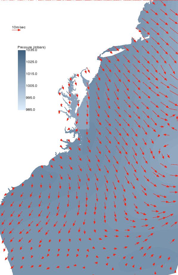
10 Noreaster
11 Combining Forecasts Need continuity between prior runs and forecast run
12

13
14 Storm Surge Modeling Process Download Atmospheric Model Output Interpolate in space to unstructured grid node points Interpolate in time to match model time step Assemble Hindcast/Nowcast data with Forecast data (Assimilation) Configure surge runs for synoptic time Submit Runs Post-process output for analysis, visualization, and sharing, and next assimilation step Repeat
15 Conclusions Working with local atmospheric modelers provides high quality winds for storm surge and inundation modeling, but requires more data management infrastructure and automation than research models. Standardization of data and metadata enables interoperability with data providers modelers and data consumers The flexibility provided by using the metadata enables near-real-time research and realtime forecasting
16 End
17 Atmospheric Models Synoptic Times: 00Z, 06Z, 12Z, 18Z Surface and MSL winds and pressures Models: GFS 0.5 degree X 3hr for 84 hr NAM (AWIP12): 12km grid X 3hr for 84 hr Weatherflow: 8km and 2km grids X 1hr for 36hr Wakefield WRF-GFS: (8km or 4km) X 1hr for 24hr Wakefield WRF-NAM: (8km or 4km) X 1 hr for 24hr

18 Inundation Model Hampton Roads
19 Chesapeake Bay Bridge Tunnel Results for Isabel Surge Ensemble Image courtesy of Noblis

20 Inundation Grids DC/Upper Potomac Hampton Roads VA Dorchester, MD York River Forcing: East Coast ELCIRC U,V,Pressure Ensemble of Winds GFS 0.5deg NAM 12km WRF-NAM WRF-GFS Weatherflow
21 Gloucester Point Tide Gauge Damaged

22 Inundation Model Dorchester

23 Dorchester Land Cells

24 Dorchester Detail

25 Potomac Inundation Grid Extent

26 Potomac Inundation Grid Detail
The Storm Surge and Inundation Modeling for Nor easter Event in the Chesapeake Bay, and Super-Regional Testbed in the Gulf of Mexico
 The Storm Surge and Inundation Modeling for Nor easter Event in the Chesapeake Bay, and Super-Regional Testbed in the Gulf of Mexico Harry Wang, Jie Gao, Derek Loftis and Yi-cheng Teng Department of Physical
Hyperlocal Marine Weather: What s Happening?
 Hyperlocal Marine Weather: What s Happening? André van der Westhuysen 1,2 and Jeff McQueen 1 1 NOAA / National Weather Service National Centers for Environmental Prediction 2 I.M Systems Group, Rockville
UNDERSTANDING STORM TIDES
 UNDERSTANDING STORM TIDES Run from the water, hide from the wind.. CATEGORY CATEGORY CATEGORY CATEGORY CATEGORY 1 2 3 4 5 WIND 74-95 mph 64-82 knots 96-110 mph 83-95 knots 111-130 mph 96-113 knots 131-155
Chile / Dirección Meteorológica de Chile (Chilean Weather Service)
") JOINT WMO TECHNICAL PROGRESS REPORT ON THE GLOBAL DATA PROCESSING AND FORECASTING SYSTEM AND NUMERICAL WEATHER PREDICTION RESEARCH ACTIVITIES FOR 2015 Chile / Dirección Meteorológica de Chile (Chilean
JOINT WMO TECHNICAL PROGRESS REPORT ON THE GLOBAL DATA PROCESSING AND FORECASTING SYSTEM AND NUMERICAL WEATHER PREDICTION RESEARCH ACTIVITIES FOR 2015 Chile / Dirección Meteorológica de Chile (Chilean
IRENE: Visitor from the Extratidal World
 IRENE: Visitor from the Extratidal World John Boon Professor Emeritus Virginia Institute of Marine Science School of Marine science College of William and Mary Hurricane Irene did not come to Hampton Roads
Impact of Sea Level Rise on Future Storm-induced Coastal Inundation
 Impact of Sea Level Rise on Future Storm-induced Coastal Inundation Changsheng Chen School for Marine Science and Technology, University of Massachusetts-Dartmouth Email: c1chen@umassd.edu 04/14/2015 Outline
CONDUIT Update Cooperative Opportunity for NCEP Data using IDD Technology Rebecca Cosgrove NCEP/NCO/Production Management Branch September 15, 2014
 CONDUIT Update Cooperative Opportunity for NCEP Data using IDD Technology Rebecca Cosgrove NCEP/NCO/Production Management Branch September 15, 2014 Agenda Technology Refresh Data available today NOAAPORT/SBN
1.2 DEVELOPMENT OF THE NWS PROBABILISTIC EXTRA-TROPICAL STORM SURGE MODEL AND POST PROCESSING METHODOLOGY
 1.2 DEVELOPMENT OF THE NWS PROBABILISTIC EXTRA-TROPICAL STORM SURGE MODEL AND POST PROCESSING METHODOLOGY Huiqing Liu 1 and Arthur Taylor 2* 1. Ace Info Solutions, Reston, VA 2. NOAA / NWS / Science and
A Cloud-Based Flood Warning System For Forecasting Impacts to Transportation Infrastructure Systems
 A Cloud-Based Flood Warning System For Forecasting Impacts to Transportation Infrastructure Systems Jon Goodall Associate Professor, Civil and Environmental Engineering Associate Director, Link Lab April
Gridded Localized Aviation MOS Program (LAMP) Guidance for Aviation Forecasting
 Guidance for Aviation Forecasting") Gridded Localized Aviation MOS Program (LAMP) Guidance for Aviation Forecasting Judy E. Ghirardelli and Bob Glahn National Weather Service Meteorological Development Laboratory August 2, 2011 15th Conference
Gridded Localized Aviation MOS Program (LAMP) Guidance for Aviation Forecasting Judy E. Ghirardelli and Bob Glahn National Weather Service Meteorological Development Laboratory August 2, 2011 15th Conference
GOES-R. Getting ready for the next generation earth observing system. Yuguang He AER April 10, 2015
 GOES-R Getting ready for the next generation earth observing system Yuguang He AER April 10, 2015 Outline! AER in research and applica0ons! AER on GOES- R! GOES- R: the next genera0on! Ge:ng ready for
Advances in Coastal Inundation Simulation Using Unstructured-Grid Coastal Ocean Models
 Advances in Coastal Inundation Simulation Using Unstructured-Grid Coastal Ocean Models Bob Beardsley (WHOI) Changsheng Chen (UMass-Dartmouth) Bob Weisberg (U. South Florida) Joannes Westerink (U. Notre
RHOAPS. Real-time Hydrology Ocean Atmosphere Prediction System. Pronunciation: Ropes Motto: More than just THREDDS
 RHOAPS Real-time Hydrology Ocean Atmosphere Prediction System Pronunciation: Ropes Motto: More than just THREDDS Key Aspects Integrated real-time data systems Atmospheric Hydrologic Coastal oceans Societal
Chesapeake Inundation Prediction System (CIPS): A Regional Prototype for a National Problem
: A Regional Prototype for a National Problem") Chesapeake Inundation Prediction System (CIPS): A Regional Prototype for a National Problem Barry Stamey *, Wade Smith, Kenneth Carey, David Garbin, and Fred Klein Noblis, Inc., Falls Church, VA, USA Harry
Chesapeake Inundation Prediction System (CIPS): A Regional Prototype for a National Problem Barry Stamey *, Wade Smith, Kenneth Carey, David Garbin, and Fred Klein Noblis, Inc., Falls Church, VA, USA Harry
Lightning Data Assimilation using an Ensemble Kalman Filter
 Lightning Data Assimilation using an Ensemble Kalman Filter G.J. Hakim, P. Regulski, Clifford Mass and R. Torn University of Washington, Department of Atmospheric Sciences Seattle, United States 1. INTRODUCTION
Storm surge forecasting and other Met Office ocean modelling
 Storm surge forecasting and other Met Office ocean modelling EMODnet stakeholder meeting Clare O Neill + many others Outline Ocean modelling at the Met Office Storm surge forecasting Current operational
HFIP- Supported Improvements to Storm Surge Forecas6ng in 2012
 HFIP- Supported Improvements to Storm Surge Forecas6ng in 2012 Jesse C. Feyen (NOS/OCS), Jamie Rhome (NWS/NHC), Rick LueJch (UNC- CH), Jason Fleming (Seahorse Consul6ng), Brian Blanton (RENCI), Yuji Funakoshi
HYSPLIT RESULTS: HYSPLIT:-
 HYSPLIT RESULTS: HYSPLIT:- Lagrangian particle models compute trajectories of a large number of so-called particles to describe the transport and diffusion of tracers in the atmosphere. The main advantage
HFR Surface Currents Observing System in Lower Chesapeake Bay and Virginia Coast
 HFR Surface Currents Observing System in Lower Chesapeake Bay and Virginia Coast Larry P. Atkinson, Teresa Garner, and Jose Blanco Center for Coastal Physical Oceanography Old Dominion University Norfolk,
JOINT WMO TECHNICAL PROGRESS REPORT ON THE GLOBAL DATA PROCESSING AND FORECASTING SYSTEM AND NUMERICAL WEATHER PREDICTION RESEARCH ACTIVITIES FOR 2016
 JOINT WMO TECHNICAL PROGRESS REPORT ON THE GLOBAL DATA PROCESSING AND FORECASTING SYSTEM AND NUMERICAL WEATHER PREDICTION RESEARCH ACTIVITIES FOR 2016 New Zealand / Meteorological Service of New Zealand
An Integrated Coastal Observation and Flood Warning System: Rapid Prototype Development
 An Integrated Coastal Observation and Flood Warning System: Rapid Prototype Development Barry Stamey *, Kenneth Carey *, Wade Smith, Brant Smith, Andrew Stern, Gary Mineart, and Scot Lynn Mitretek Systems,
Critical Issues in Assessment of Offshore Wind Farm Development on Dispersion and Settling of Scallop Larvae in the Northeast U.S.
 Critical Issues in Assessment of Offshore Wind Farm Development on Dispersion and Settling of Scallop Larvae in the Northeast U.S. Coastal Ocean Changsheng Chen School for Marine Science and Technology
WRF Pre-Processing (WPS)
") NCAR Earth System Laboratory National Center for Atmospheric Research NCAR is Sponsored by NSF and this work is partially supported by the Willis Research Network and the Research Partnership to Secure
NCAR Earth System Laboratory National Center for Atmospheric Research NCAR is Sponsored by NSF and this work is partially supported by the Willis Research Network and the Research Partnership to Secure
RSMC WASHINGTON USER'S INTERPRETATION GUIDELINES ATMOSPHERIC TRANSPORT MODEL OUTPUTS
 RSMC WASHINGTON USER'S INTERPRETATION GUIDELINES ATMOSPHERIC TRANSPORT MODEL OUTPUTS -Version 2.0- (January 2007) 1. Introduction In the context of current agreements between the National Oceanic and Atmospheric
3B.3: Climate Controls on the Extreme Rainstorms in the Contiguous US:
 97 th AMS Annual Meeting 3B.3: Climate Controls on the Extreme Rainstorms in the Contiguous US: 1979-2015 Xiaodong Chen and Faisal Hossain Department of Civil and Environmental Engineering University of
Introduction to NCEP's time lagged North American Rapid Refresh Ensemble Forecast System (NARRE-TL)
") Introduction to NCEP's time lagged North American Rapid Refresh Ensemble Forecast System (NARRE-TL) Binbin Zhou 1,2, Jun Du 2, Geoff Manikin 2 & Geoff DiMego 2 1. I.M. System Group 2. EMC/NCEP/NWS/NOAA
Introduction to NCEP's time lagged North American Rapid Refresh Ensemble Forecast System (NARRE-TL) Binbin Zhou 1,2, Jun Du 2, Geoff Manikin 2 & Geoff DiMego 2 1. I.M. System Group 2. EMC/NCEP/NWS/NOAA
Improving global coastal inundation forecasting WMO Panel, UR2014, London, 2 July 2014
 Improving global coastal inundation forecasting WMO Panel, UR2014, London, 2 July 2014 Cyclone Sidr, November 2007 Hurricane Katrina, 2005 Prof. Kevin Horsburgh Head of marine physics, UK National Oceanography
Development of Operational Storm Surge Guidance to Support Total Water Predictions
 Development of Operational Storm Surge Guidance to Support Total Water Predictions J. Feyen 1, S. Vinogradov 1,2, T. Asher 3, J. Halgren 4, Y. Funakoshi 1,5 1. NOAA/NOS//Development Laboratory 2. ERT,
Urgent Computing for Hurricane Forecasts
 Urgent Computing for Hurricane Forecasts Gabrielle Allen Center for Computation & Technology Dept Computer Science Louisiana State University gallen@cct.lsu.edu Representing the SURA Coastal Ocean Observing
A SUPER-OB FOR THE WSR-88D RADAR RADIAL WINDS FOR USE IN THE NCEP OPERATI ONAL ASSIMILATION SYSTEM. NOAA/NWS/NCEP, Camp Springs, Maryland 20746
 19th Conference on IIPS P151 A SUPER-OB FOR THE WSR-88D RADAR RADIAL WINDS FOR USE IN THE NCEP OPERATI ONAL ASSIMILATION SYSTEM Jordan C Alpert 1*, Peter Pickard 2, Yukuan Song 2, Melanie Taylor 2, William
Eastern Shore Weather and Climate. Bill Sammler Warning Coordination Meteorologist National Weather Service Wakefield, VA
 Eastern Shore Weather and Climate Bill Sammler Warning Coordination Meteorologist National Weather Service Wakefield, VA About The NWS The National Weather Service is: A Federal Government Agency Part
Urban Street-Scale Hydrodynamic Flood Modeling of Micro-Burst Rainfall
 Urban Street-Scale Hydrodynamic Flood Modeling of Micro-Burst Rainfall Dr. Jon Derek Loftis Asst. Research Scientist, VA Inst. of Marine Science Sridhar Katragadda Systems Analyst, City of Virginia Beach
PROJECT DESCRIPTION. 1. Introduction Problem Statement
 Salmun, H: A proposal submitted to PSC-CUNY program on October 15, 2009. Statistical prediction of storm surge associated with East Coast Cool-weather Storms at The Battery, New York. Principal Investigator:
National Weather Service-Pennsylvania State University Weather Events
 National Weather Service-Pennsylvania State University Weather Events Heavy rainfall of 23 November 2011 by Richard H. Grumm National Weather Service State College PA 16803 Abstract:. A fast moving mid-tropospheric
The Northeast Coastal Ocean Forecast System (NECOFS) and Storm Surge and Inundation Prediction. Status and Initial Ideas
 and Storm Surge and Inundation Prediction. Status and Initial Ideas") The Northeast Coastal Ocean Forecast System (NECOFS) and Storm Surge and Inundation Prediction Status and Initial Ideas Changsheng Chen (UMassD) and Bob Beardsley (WHOI) Website: http://fvcom.smast.umassd.edu
The Northeast Coastal Ocean Forecast System (NECOFS) and Storm Surge and Inundation Prediction Status and Initial Ideas Changsheng Chen (UMassD) and Bob Beardsley (WHOI) Website: http://fvcom.smast.umassd.edu
Southern Heavy rain and floods of 8-10 March 2016 by Richard H. Grumm National Weather Service State College, PA 16803
 Southern Heavy rain and floods of 8-10 March 2016 by Richard H. Grumm National Weather Service State College, PA 16803 1. Introduction Heavy rains (Fig. 1) produced record flooding in northeastern Texas
Assessing Storm Tide Hazard for the North-West Coast of Australia using an Integrated High-Resolution Model System
 Assessing Storm Tide Hazard for the North-West Coast of Australia using an Integrated High-Resolution Model System J. Churchill, D. Taylor, J. Burston, J. Dent September 14, 2017, Presenter Jim Churchill
Fleet Numerical Meteorology and Oceanography Center. Current Sub-seasonal to Seasonal Capabilities
 Fleet Numerical Meteorology and Oceanography Center Current Sub-seasonal to Seasonal Capabilities presented at Workshop on Metrics, Post-Processing, and Products for S2S 28 Feb 2018 Chuck Skupniewicz Modeling
Operational Estuarine & Coastal Forecast Systems in NOAA s. National Ocean Service
 Operational Estuarine & Coastal Forecast Systems in NOAA s. National Ocean Service Eugene Wei, Frank Aikman III and Richard Patchen NOAA S S National Ocean Service Workshop on: Data Assimilation in Support
Chester River Shallow Water Project SCHISM model results
 Chester River Shallow Water Project SCHISM model results Harry Wang, Joseph Zheng, Fei Ye, Zhengui Wang, and Xiaonan Li Virginia Institute of Marine Science, College of William and Mary Gloucester Point,
2 July 2013 Flash Flood Event
 2 July 2013 Flash Flood Event By Richard H. Grumm and Charles Ross National Weather Service State College, PA 1. Overview A retrograding 500 hpa cyclone and anticyclone (Fig. 1) set up deep southerly flow
PREDICTION OF OIL SPILL TRAJECTORY WITH THE MMD-JMA OIL SPILL MODEL
 PREDICTION OF OIL SPILL TRAJECTORY WITH THE MMD-JMA OIL SPILL MODEL Project Background Information MUHAMMAD HELMI ABDULLAH MALAYSIAN METEOROLOGICAL DEPARTMENT(MMD) MINISTRY OF SCIENCE, TECHNOLOGY AND INNOVATION
Cooperative Institute for Meteorological Satellite Studies University of Wisconsin - Madison
 1 Content Introduction Visualize Analyze Validate/ Deep-dive Summary 2 Introduction. McIDAS-V is a powerful and versatile visualization and data analysis software. It is Java based, open source and freely
Weather Forecasting. March 26, 2009
 Weather Forecasting Chapter 13 March 26, 2009 Forecasting The process of inferring weather from a blend of data, understanding, climatology, and solutions of the governing equations Requires an analysis
Speedwell High Resolution WRF Forecasts. Application
 Speedwell High Resolution WRF Forecasts Speedwell weather are providers of high quality weather data and forecasts for many markets. Historically we have provided forecasts which use a statistical bias
Recent development of the National Hydro-Meteorological Service (NHMS) of Viet Nam for disaster risk reduction
 of Viet Nam for disaster risk reduction") Ministry of Natural Resources and Environment National Hydro-Meteorological Service Recent development of the National Hydro-Meteorological Service (NHMS) of Viet Nam for disaster risk reduction Tran Van
Ministry of Natural Resources and Environment National Hydro-Meteorological Service Recent development of the National Hydro-Meteorological Service (NHMS) of Viet Nam for disaster risk reduction Tran Van
John Callahan (Delaware Geological Survey) Kevin Brinson, Daniel Leathers, Linden Wolf (Delaware Environmental Observing System)
 Kevin Brinson, Daniel Leathers, Linden Wolf (Delaware Environmental Observing System)") John Callahan (Delaware Geological Survey) Kevin Brinson, Daniel Leathers, Linden Wolf (Delaware Environmental Observing System) Delaware is extremely vulnerable to the impacts of coastal flooding Tropical
John Callahan (Delaware Geological Survey) Kevin Brinson, Daniel Leathers, Linden Wolf (Delaware Environmental Observing System) Delaware is extremely vulnerable to the impacts of coastal flooding Tropical
Simulation of storm surge and overland flows using geographical information system applications
 Coastal Processes 97 Simulation of storm surge and overland flows using geographical information system applications S. Aliabadi, M. Akbar & R. Patel Northrop Grumman Center for High Performance Computing
Development of a Real-time Ensemble Sensitivity Tool to Assess the Predictability of High Impact Weather during the Cool Season
 Development of a Real-time Ensemble Sensitivity Tool to Assess the Predictability of High Impact Weather during the Cool Season Dr. Brian A. Colle, Minghua Zhang, and Dr. Edmund Chang Stony Brook University
DSJRA-55 Product Users Handbook. Climate Prediction Division Global Environment and Marine Department Japan Meteorological Agency July 2017
 DSJRA-55 Product Users Handbook Climate Prediction Division Global Environment and Marine Department Japan Meteorological Agency July 2017 Change record Version Date Remarks 1.0 13 July 2017 First version
Moving Freshwater to the Ocean: Hydrology-Ocean Model Coupling
 Moving Freshwater to the Ocean: Hydrology-Ocean Model Coupling Cheryl Ann Blain 1, Tim Campbell 1, Song Yang 2, Aubrey Dugger 3, Paul Martin 1, Tommy Jenson 1 Naval Research Laboratory 1 Oceanography Division,
Saiful Islam Anisul Haque
 Workshop on Disaster Prevention/Mitigation Measures against Floods and Storm Surges in Bangladesh on 17-21 November, 2012, in Kyoto University, Japan Component 2: Flood disaster risk assessment and mitigation
Polar WRF. Polar Meteorology Group Byrd Polar and Climate Research Center The Ohio State University Columbus Ohio
 Polar WRF David H. Bromwich, Keith M. Hines, Lesheng Bai and Sheng-Hung Wang Polar Meteorology Group Byrd Polar and Climate Research Center The Ohio State University Columbus Ohio Byrd Polar and Climate
ECPC/NCEP March 2008 Seasonal Fire Danger Forecasts J. Roads 1, P. Tripp 1, H. Juang 2, J. Wang 2, S. Chen 3, F. Fujioka 3
 Roads, J., P. Tripp, H. Juang, J. Wang, S. Chen, F. Fujioka, 2008: ECPC/NCEP March 2008 Seasonal Fire Danger Forecasts. Experimental Long-Lead Forecasts Bulletin, 17, 7 pp. ECPC/NCEP March 2008 Seasonal
The Developmental Testbed Center (DTC) Steve Koch, NOAA/FSL
 Steve Koch, NOAA/FSL") The Developmental Testbed Center (DTC) Steve Koch, NOAA/FSL A facility where the NWP research and operational communities interact to accelerate testing and evaluation of new models and techniques for
The Developmental Testbed Center (DTC) Steve Koch, NOAA/FSL A facility where the NWP research and operational communities interact to accelerate testing and evaluation of new models and techniques for
Overview of NOS Coastal Ocean Operational Forecast Systems
 Overview of NOS Coastal Ocean Operational Forecast Systems Aijun Zhang NOAA/NOS Center for Operational Oceanographic Products and Services (CO-OPS) Frank Aikman III NOAA/NOS/OCS Coast Survey Development
CATEX Hurricane Zachary
 CATEX Hurricane Zachary EXERCISE, EXERCISE,EXERCISE East Coast CATEX Power Restoration Functional Exercise 2013 This document was prepared under a grant from FEMA's Grants Programs Directorate, U.S. Department
The Role of the SURA Testbed in the Improvement of U.S. Coastal and Estuarine Prediction
 Super-Regional Testbed for Improving Forecasts of Environmental Processes for the U.S. Atlantic and Gulf of Mexico Coasts The Role of the SURA Testbed in the Improvement of U.S. Coastal and Estuarine Prediction
A description of these quick prepbufrobs_assim text files is given below.
 The 20 th Century Reanalysis (20CR) Project Ensemble Filter data assimilation system produces ASCII text files containing the surface and sea level pressure observations used in the assimilation, essential
Strategic Radar Enhancement Project (SREP) Forecast Demonstration Project (FDP) The future is here and now
 Forecast Demonstration Project (FDP) The future is here and now") Strategic Radar Enhancement Project (SREP) Forecast Demonstration Project (FDP) The future is here and now Michael Berechree National Manager Aviation Weather Services Australian Bureau of Meteorology
Strategic Radar Enhancement Project (SREP) Forecast Demonstration Project (FDP) The future is here and now Michael Berechree National Manager Aviation Weather Services Australian Bureau of Meteorology
NWS Operational Marine and Ocean Forecasting. Overview. Ming Ji. Ocean Prediction Center National Weather Service/NCEP. CIOSS/CoRP
 NWS Operational Marine and Ocean Forecasting Overview Ming Ji Ocean Prediction Center National Weather Service/NCEP CIOSS/CoRP CoRP Symposium Corvallis, OR Aug. 12-13, 13, 2008 Titanic Telegram Marine
Forcing ocean model with atmospheric model outputs to simulate storm surge in the Bangladesh coast
 Forcing ocean model with atmospheric model outputs to simulate storm surge in the Bangladesh coast Nabir Mamnun 1, 2, Lucy Brechino 3, Md. Rashed-Un-Nabi 2 1. Nansen-Bangladesh International Centre for
Transitions. Newsletter Spring-Summer By stimulating the use of operational codes by the research community, composed of
 Developmental Testbed Center DTC Transitions Newsletter Spring-Summer 2015 ISSUE 8 Courtesy of Paula McCaslin INSIDE THIS ISSUE DIRECTOR S CORNER 1,2 NITE ARTICLE 1,2 BRIDGES TO OPERATIONS 3 WHO S WHO
SLOSH New Orleans Basin 2012 Update
 SLOSH New Orleans Basin 2012 Update Michael Koziara Science and Operations Officer National Weather Service Slidell, LA The Basics What is storm surge? What is SLOSH? Details Assumptions Inundation = Storm
Forecast Predictions of Winds, Waves and Storm Surge during Hurricane Arthur (2014)
") Forecast Predictions of Winds, Waves and Storm Surge during Hurricane Arthur (2014) R Cyriac 1, JC Dietrich 1, JG Fleming 2, BO Blanton 3, RA Luettich Jr 4, C Kaiser 5 1 Dept. of Civil, Construction, and
Forecast Predictions of Winds, Waves and Storm Surge during Hurricane Arthur (2014) R Cyriac 1, JC Dietrich 1, JG Fleming 2, BO Blanton 3, RA Luettich Jr 4, C Kaiser 5 1 Dept. of Civil, Construction, and
ERDC Support for Hurricane Sandy
 ERDC Support for Hurricane Sandy Chris Massey, CHL; Aaron Byrd, CHL; Nawa Pradhan, CHL; Jeff Melby, CHL; Jane Smith, CHL; Robert Walker, ITL; and Jennifer Wozencraft, JALBTCX ERDC Support for Hurricane
Estimation of Wave Heights during Extreme Events in Lake St. Clair
 Abstract Estimation of Wave Heights during Extreme Events in Lake St. Clair T. J. Hesser and R. E. Jensen Lake St. Clair is the smallest lake in the Great Lakes system, with a maximum depth of about 6
Experimental Probabilistic Hurricane Inundation Surge Height (PHISH) Guidance
 Guidance") Experimental Probabilistic Hurricane Inundation Surge Height (PHISH) Guidance DRBC Flood Advisory Committee John Kuhn - NWS/OCWWS Anne Myckow (NWS/MDL), Arthur Taylor (NWS/MDL) SLOSH Sea, Lake and Overland
Experimental Probabilistic Hurricane Inundation Surge Height (PHISH) Guidance DRBC Flood Advisory Committee John Kuhn - NWS/OCWWS Anne Myckow (NWS/MDL), Arthur Taylor (NWS/MDL) SLOSH Sea, Lake and Overland
NOAA Inundation Dashboard
 NOAA Inundation Dashboard Audra Luscher & Paul Fanelli NOS Center for Operational Oceanographic Products & Services (CO-OPS) Hampton Roads Sea Level Rise/Flooding Adaptation Forum July 29, 2016 http://tidesandcurrents.noaa.gov/inundationdb/newyork.html
SCOTIA WEATHER SERVICES INC.
 SCOTIA WEATHER SERVICES INC. Mission To provide high quality, reliable valued-added environmental information services based on measured and modeled atmospheric, land and/or oceanographic physical parameters
Unidata Policy Meeting Key Program Status
 Unidata Policy Meeting Key Program Status May 14, 2013 Where America s Climate, Weather, Ocean and Space Weather Services Begin Agenda Sandy Supplemental Integrated Dissemination Program AWIPS2 May, 2013
Topics 1. IOOS on the US East Coast. 2. Regional Physical & Ecosystem Modeling Efforts
 Topics 1. IOOS on the US East Coast National Federation of Regional Associations http://usnfra.org - NERACOOS - MACOORA 2. Regional Physical & Ecosystem Modeling Efforts Northeast Regional Association
P3.1 Development of MOS Thunderstorm and Severe Thunderstorm Forecast Equations with Multiple Data Sources
 P3.1 Development of MOS Thunderstorm and Severe Thunderstorm Forecast Equations with Multiple Data Sources Kathryn K. Hughes * Meteorological Development Laboratory Office of Science and Technology National
Integrating Hydrologic and Storm Surge Models for Improved Flood Warning
 Integ Hydrologic and Storm Surge Models for Improved Flood Warning Leahy, C.P, Entel, M, Sooriyakumaran, S, and Warren, G Flood Warning Program Office, Bureau of Meteorology, Docklands, Victoria National
Forecast of Nearshore Wave Parameters Using MIKE-21 Spectral Wave Model
 Forecast of Nearshore Wave Parameters Using MIKE-21 Spectral Wave Model Felix Jose 1 and Gregory W. Stone 2 1 Coastal Studies Institute, Louisiana State University, Baton Rouge, LA 70803 2 Coastal Studies
Establishing the Weather Research and Forecast (WRF) Model at NWS Miami and Incorporating Local Data sets into Initial and Boundary Conditions
 Model at NWS Miami and Incorporating Local Data sets into Initial and Boundary Conditions") Establishing the Weather Research and Forecast (WRF) Model at NWS Miami and Incorporating Local Data sets into Initial and Boundary Conditions COMET Outreach Project S04-44694 January 9, 2006 Dr. Brian
Establishing the Weather Research and Forecast (WRF) Model at NWS Miami and Incorporating Local Data sets into Initial and Boundary Conditions COMET Outreach Project S04-44694 January 9, 2006 Dr. Brian
Climate Data for Non-experts: Standards-based Interoperability
 Climate Data for Non-experts: Standards-based Interoperability Ben Domenico Unidata Program Center University Corporation for Atmospheric Research April 2010 Working Together on A Mosaic for Atmospheric
Coupling of Wave and Hydrodynamic Models for Predicting Coastal Inundation: A case study in Jakarta and Semarang
 Coupling of Wave and Hydrodynamic Models for Predicting Coastal Inundation: A case study in Jakarta and Semarang http://peta-maritim.bmkg.go.id/cifdp/maps Nelly Florida Riama,Andri Ramdhani, Andi Eka Sakya,,
Habitat Suitability for Forage Fishes in Chesapeake Bay
 Habitat Suitability for Forage Fishes in Chesapeake Bay Aug 2017 Jul 2019 Mary C Fabrizio Troy D Tuckey Aaron J Bever Michael L MacWilliams 21 June 2018 Photo: Chesapeake Bay Program Motivation Production
Tropical Storm Hermine: Heavy rainfall in western Gulf By Richard H. Grumm National Weather Service Office State College, PA 16803
 Tropical Storm Hermine: Heavy rainfall in western Gulf By Richard H. Grumm National Weather Service Office State College, PA 16803 1. INTRODUCTION Tropical storm Hermine, the eighth named tropical system
The Costs of Doing Nothing: Economic Consequences of Not Adapting to Sea Level Rise in the Hampton Roads Region. Photo courtesy of VIMS
 The Costs of Doing Nothing: Economic Consequences of Not Adapting to Sea Level Rise in the Hampton Roads Region Photo courtesy of VIMS Costs of Doing Nothing: Economic Consequences of Not Adapting to Sea
RSMC WASHINGTON USER'S INTERPRETATION GUIDELINES ATMOSPHERIC TRANSPORT MODEL OUTPUTS
 RSMC WASHINGTON USER'S INTERPRETATION GUIDELINES ATMOSPHERIC TRANSPORT MODEL OUTPUTS (January 2015) 1. Introduction In the context of current agreements between the National Oceanic and Atmospheric Administration
Adaptation to Sea Level Rise A Regional Approach
 Adaptation to Sea Level Rise A Regional Approach Project Partners: in Saco Bay, ME Peter Slovinsky, Marine Geologist Maine Geological Survey, Department of Conservation Project Funding from: Saco Bay Hazards
Add NOAA nowcoast Layers to Maps
 WebEOC Maps Add-on Quick Reference Guide Add NOAA nowcoast Layers to Maps Overview With Maps Add-on, you can configure an unlimited number of map layers. These layers allow you to control the data you
Darren Wright Maritime Services Program Manager Center for Operational Oceanographic Products and Services (CO-OPS)
") Darren Wright Maritime Services Program Manager Center for Operational Oceanographic Products and Services (CO-OPS) Center for Operational Oceanographic Products and Services (CO-OPS) National Water Level
Darren Wright Maritime Services Program Manager Center for Operational Oceanographic Products and Services (CO-OPS) Center for Operational Oceanographic Products and Services (CO-OPS) National Water Level
Earth Observation in coastal zone MetOcean design criteria
 ESA Oil & Gas Workshop 2010 Earth Observation in coastal zone MetOcean design criteria Cees de Valk BMT ARGOSS Wind, wave and current design criteria geophysical process uncertainty modelling assumptions
Hazard Impact Modelling for Storms Workshop
 The UK s trusted voice for coordinated natural hazards advice Hazard Impact Modelling for Storms Workshop Ken Mylne, Becky Hemingway, Ervin Zsoter ECMWF UEF 2017, 15 th June 2017 The UK s trusted voice
Egyptian Meteorological Authority Cairo Numerical Weather prediction centre
 JOINT WMO TECHNICAL PROGRESS REPORT ON THE GLOBAL DATA PROCESSING AND FORECASTING SYSTEM AND NUMERICAL WEATHER PREDICTION RESEARCH ACTIVITIES FOR 2016 Egyptian Meteorological Authority Cairo Numerical
A multi-tiered ADCIRC-based storm surge and wave prediction system
 A multi-tiered ADCIRC-based storm surge and wave prediction system Brian Blanton, Renaissance Computing Institute, UNC-Chapel Hill Rick Luettich, Institute of Marine Sciences, UNC-Chapel Hill, co-pi Jason
North Atlantic Coast Comprehensive Study (NACCS) APPENDIX A: ENGINEERING
 APPENDIX A: ENGINEERING") North Atlantic Coast Comprehensive Study (NACCS) APPENDIX A: ENGINEERING NORTH ATLANTIC COAST COMPREHENSIVE STUDY: RESILIENT ADAPTATION TO INCREASING RISK Appendix A - Engineering Table of Contents North
North Atlantic Coast Comprehensive Study (NACCS) APPENDIX A: ENGINEERING NORTH ATLANTIC COAST COMPREHENSIVE STUDY: RESILIENT ADAPTATION TO INCREASING RISK Appendix A - Engineering Table of Contents North
CW3E Atmospheric River Update Outlook Strong AR forecast to impact California this weekend - A strong AR with IVT as high as 1000 kg m -1 s -1 is
 CW3E Atmospheric River Update Outlook Strong AR forecast to impact California this weekend - A strong AR with IVT as high as 1000 kg m -1 s -1 is forecast make landfall over the West Coast this Weekend
NDIA System Engineering Conference 26 October Benjie Spencer Chief Engineer, NOAA/National Weather Service
 NDIA System Engineering Conference 26 October 2015 Benjie Spencer Chief Engineer, NOAA/National Weather Service The National Weather Service of the Future: Building a Weather-Ready Nation Previous NWS
Coupled Wind, Wave, and Surge Modeling. Pat Welsh University of North Florida 10th International Wave Conference 12 November 2007
 Coupled Wind, Wave, and Surge Modeling Pat Welsh University of North Florida 10th International Wave Conference 12 November 2007 Current AWIS Lab Project & Proposals Collaborators Our Lab is too small
London Heathrow Field Site Metadata
 London Heathrow Field Site Metadata Field Site Information Name: Heathrow src_id (Station ID number): 708 Geographic Area: Greater London Latitude (decimal ): 51.479 Longitude (decimal ): -0.449 OS Grid
Using Weather Pattern Analysis to Identify Periods of Heightened Coastal Flood Risk in the Medium to Long Range
 UEF 2017 - Storms Using Weather Pattern Analysis to Identify Periods of Heightened Coastal Flood Risk in the Medium to Long Range David Price (FFC) and Robert Neal (Met Office) Thursday 15 June The Flood
Implementing a vector-based river routing scheme within the WRF-Hydro modeling system
 Implementing a vector-based river routing scheme within the WRF-Hydro modeling system Peirong Lin 1, Zong-Liang Yang 1, David Gochis 2, Wei Yu 2, Cédric H. David 3, David Maidment 4 1. Jackson School of
New Zealand Heavy Rainfall and Floods
 New Zealand Heavy Rainfall and Floods 1. Introduction Three days of heavy rainfall associated with a deep upper-level low (Fig. 1) brought flooding to portions of New Zealand (Fig. 2). The flooding was
HYCOM in the South Atlantic Bight: Performance and Client Applications
 HYCOM in the South Atlantic Bight: Performance and Client Applications Brian Blanton, Alfredo Aretxabaleta Department of Marine Sciences UNC-Chapel Hill UNC Group Activities HYCOM/GODAE NOPP Provide SEACOOS
The history of infrastructures and the future of cyberinfrastructure in the Earth system sciences
 The history of infrastructures and the future of cyberinfrastructure in the Earth system sciences SciencesPo, Paris (2012-13) School of Information and Dept. of History, University of Michigan The Meteorological