ABI: Vertical Res km Horizontal Res. 2-km. Horizontal Res. 14-km Time Res min. Time Res. 1-7 hr.
|
|
|
- Brenda Edwards
- 5 years ago
- Views:
Transcription
1 Combining Polar Hyper-spectral and Geostationary Multi-spectral Sounding Data A Method to Optimize Sounding Spatial and Temporal Resolution W. L. Smith!,2, E. Weisz 1, and J. McNabb 2 1 University of Wisconsin, Madison WI, USA ; 2 Hampton University, Hampton VA, USA ABI: Vertical Res km AIRS, PHS: IASI, CrIS: Vertical Vertical Res. 1-4 Res. km1-4 km Horizontal Res. 2-km Horizontal Res. 14-km Time Res min. Time Res. 1-7 hr.
2 HU CARE Hampton
3


4 Polar-Orbiting Ultra-Spectral & Geostationary Sounders GOES-16 ABI ABI GOES-16 Radiometer GOES cm μm 16 / / km 2016
5 PHS (CrIS/IASI) + ABI Sounding ABI/PHS = ABI (x,y,t) + [PHS (x o,y o,t o )- ABI (x o,y o,t o )] ABI (x,y,t): ABI retrieval value at location and time (x, y, t) PHS (x o,y o,t o ): Mean of 5 reference PHS values closest to ABI location and time (x, y, t) ABI (x o,y o,t o ): Mean of 5 reference PHS Field-of-View average ABI retrieval values closest to the ABI location and time (x, y, t) Implicit Assumption: The vertical resolution induced error of multi-spectral ABI retrievals is persistent over the time interval between the acquisition times of the high vertical resolution polar hyperspectral soundings and over the spatial scale (i.e., 14-km) of the hyperspectral sounding data.

 @")
6 Combining 500 hpa ABI with PHS 15:00 UTC

 @")
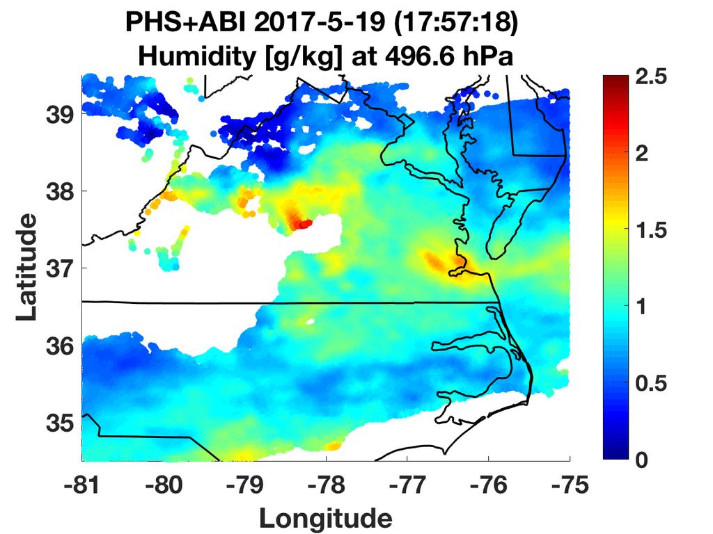
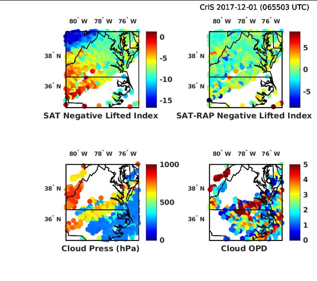
7 Combining ABI with PHS 17:55 UTC
 ABI (18 UTC) IASI (14")
 IASI (14 UTC)+ABI CrIS (18")
8 CrIS + ABI Vs Radiosondes (May 19, 2017) ABI (18 UTC) IASI (14 UTC)+ABI CrIS (18 UTC)+ABI ABI (18 UTC) IASI (14 UTC)+ABI CrIS (18 UTC)+ABI


9 IASI + ABI Predicted CrIS + ABI IASI + ABI Predicted CrIS + ABI IASI + ABI Predicted CrIS + ABI
10 PHS+ABI Time Series (MOVIE)
11 IASI-A +ABI
12 IASI-A +ABI

13 IASI-A +ABI
14 IASI-B +ABI
15 IASI-B +ABI
16 IASI-B +ABI IASI-B +ABI IASI-B +ABI
17 IASI-B +ABI
18 IASI-B +ABI
19 CrIS +ABI
20 CrIS +ABI
21 Atmospheric Stability Change


22 HR Severe Weather Not Predicted by NWS (May 19, 2017) Day 1 Risk Area (sq. mi.) Area Pop. Some Larger Population Centers in Risk Area ENHANCED 48,447 7,656,120 Dallas, TX...Fort Worth, TX...Arlington, TX...Plano, TX...Garland, TX... SLIGHT 194,795 19,485,383 Columbus, OH...Oklahoma City, OK...Kansas City, MO...Tulsa, OK...Wichita, KS... MARGINAL 294,539 67,316,656 New York, NY...Philadelphia, PA...Indianapolis, IN...Austin, TX...Baltimore, MD... Probabilistic Tornado Graphic


")
23 HR Severe Weather Predicted by NWS ( May 22, 2017)
24 Summary and Conclusions Profile Retrievals from Polar Hyperspectral Sounders and Geostationary Multi-spectral Instruments to Optimize the Vertical, Horizontal, and Temporal resolution of the Satellite Sounding Product Improving low altitude sounding coverage in partly cloudy areas Observe spatial mesoscale details important for intense weather prediction Provide high temporal resolution for predicting the onset of severe convection Provide altitude-resolved water vapor imagery time sequences potentially useful for estimating 4-d wind profiles for NWP applications Technique Can Provide Near-Global Coverage Using be Polar Satellite Hyperspectral Sounders (e.g., IASI, CrIS, HIRAS) Data Obtained Using the International Network of Direct Broadcast Systems (e.g., DBnet) and Geostationary Satellite Multi-spectral Instruments (e.g., ABI, AHI, AMI, and SEVIRI) PHS + ABI is NOT a replacement for the Geo-Hyperspectral Sounder
Combining Polar Hyper-spectral and Geostationary Multi-spectral Sounding Data A Method to Optimize Sounding Spatial and Temporal Resolution
 Combining Polar Hyper-spectral and Geostationary Multi-spectral Sounding Data A Method to Optimize Sounding Spatial and Temporal Resolution W. L. Smith 1,2, E. Weisz 1, and J. McNabb 2 1 University of
Dual-Regression Surface and Atmospheric Sounding Algorithm for Initializing Physical Retrievals and Direct Radiance Assimilation
 SPACE SCIENCE AND ENGINEERING CENTER Dual-Regression Surface and Atmospheric Sounding Algorithm for Initializing Physical Retrievals and Direct Radiance Assimilation W. L. Smith Sr. 1,2,3, E. Weisz 1,
The May 2013 SNPP Cal/Val Campaign Validation of Satellite Soundings W. L. Smith Sr., A. M. Larar, H. E. Revercomb, M. Yesalusky, and E.
 The May 2013 SNPP Cal/Val Campaign Validation of Satellite Soundings W. L. Smith Sr., A. M. Larar, H. E. Revercomb, M. Yesalusky, and E. Weisz May 2013 Suomi NPP Aircraft Campaign SHIS, NAST I, NAST M,MASTER/AVIRIS
Applications of future GEO advanced IR sounder for high impact weather forecasting demonstration with regional OSSE
 Applications of future GEO advanced IR sounder for high impact weather forecasting demonstration with regional OSSE Jun Li @, Tim Schmit &, Zhenglong Li @, Feng Zhu @*, Pei Wang @*, Agnes Lim @, and Robert
Feature-tracked 3D Winds from Satellite Sounders: Derivation and Impact in Global Models
 Feature-tracked 3D Winds from Satellite Sounders: Derivation and Impact in Global Models David Santek 1, A.-S. Daloz 1, S. Tushaus 1, M. Rogal 1, W. McCarty 2 1 Space Science and Engineering Center/University
Introduction of the Hyperspectral Environmental Suite (HES) on GOES-R and beyond
 on GOES-R and beyond") Introduction of the Hyperspectral Environmental Suite (HES) on GOES-R and beyond Timothy J. Schmit SaTellite Applications and Research (STAR) Advanced Satellite Products Team (ASPT) Presented by Jun Li
Introduction of the Hyperspectral Environmental Suite (HES) on GOES-R and beyond Timothy J. Schmit SaTellite Applications and Research (STAR) Advanced Satellite Products Team (ASPT) Presented by Jun Li
Hyperspectral IR clear and cloudy sounding retrieval study
 Hyperspectral IR clear and cloudy sounding retrieval study Jun Li @, Timothy J. Schmit #, Chian-Yi Liu @, Elisabeth Weisz @, Li Guan @, and Allen Huang @ @Cooperative Institute for Meteorological Satellite
Introduction of the Hyperspectral Environmental Suite (HES) on GOES-R and beyond
 on GOES-R and beyond") Introduction of the Hyperspectral Environmental Suite (HES) on GOES-R and beyond 1 Timothy J. Schmit, 2 Jun Li, 3 James Gurka 1 NOAA/NESDIS, Office of Research and Applications, Advanced Satellite Products
Introduction of the Hyperspectral Environmental Suite (HES) on GOES-R and beyond 1 Timothy J. Schmit, 2 Jun Li, 3 James Gurka 1 NOAA/NESDIS, Office of Research and Applications, Advanced Satellite Products
PRECONVECTIVE SOUNDING ANALYSIS USING IASI AND MSG- SEVIRI
 PRECONVECTIVE SOUNDING ANALYSIS USING IASI AND MSG- SEVIRI Marianne König, Dieter Klaes EUMETSAT, Eumetsat-Allee 1, 64295 Darmstadt, Germany Abstract EUMETSAT operationally generates the Global Instability
1. INTRODUCTION 2. CASE STUDIES DESCRIPTION
 27 Communicating Timely Information on Convective Available Potential Energy () using Geostationary and Polar Orbiting Satellite Sounders: Application to El Reno Event Jessie Gartzke 1,3, Steve Ackerman
An Overview of the UW Hyperspectral Retrieval System for AIRS, IASI and CrIS
 An Overview of the UW Hyperspectral Retrieval System for AIRS, IASI and CrIS Nadia Smith a, Elisabeth Weisz b and William L. Smith Cooperative Institute for Meteorological Satellite Studies (CIMSS) Space
Single footprint sounding, surface emissivity and cloud property retrievals from hyperspectral infrared radiances under all sky conditions
 Single footprint sounding, surface emissivity and cloud property retrievals from hyperspectral infrared radiances under all sky conditions Jun Li @, Elisabeth Weisz @, Jinlong Li @, Allen Huang @, Chian-Yi
Hampton University 2. University of Wisconsin-Madison 3. NASA Langley Research Center
 Ultra High Spectral Resolution Satellite Remote Sounding - Results from Aircraft and Satellite Measurements W. L. Smith Sr. 1,2, D.K. Zhou 3, A. M. Larar 3, and H. E. Revercomb 2 1 Hampton University 2
CIMSS Hyperspectral IR Sounding Retrieval (CHISR) Processing & Applications
 Processing & Applications") CIMSS Hyperspectral IR Sounding Retrieval (CHISR) Processing & Applications Jun Li @, Elisabeth Weisz @, Jinlong Li @, Hui Liu #, Timothy J. Schmit &, Jason Otkin @ and many other CIMSS collaborators @Cooperative
CIMSS Hyperspectral IR Sounding Retrieval (CHISR) Processing & Applications Jun Li @, Elisabeth Weisz @, Jinlong Li @, Hui Liu #, Timothy J. Schmit &, Jason Otkin @ and many other CIMSS collaborators @Cooperative
Impact of hyperspectral IR radiances on wind analyses
 Impact of hyperspectral IR radiances on wind analyses Kirsti Salonen and Anthony McNally Kirsti.Salonen@ecmwf.int ECMWF November 30, 2017 Motivation The upcoming hyper-spectral IR instruments on geostationary
Forecast of hurricane track and intensity with advanced IR soundings
 Forecast of hurricane track and intensity with advanced IR soundings Jun Li @, Hui Liu #, Jinlong Li @, and Tim Schmit & @CIMSS/SSEC, University of Wisconsin-Madison #National Center for Atmospheric Research
Retrieval Algorithm Using Super channels
 Retrieval Algorithm Using Super channels Xu Liu NASA Langley Research Center, Hampton VA 23662 D. K. Zhou, A. M. Larar (NASA LaRC) W. L. Smith (HU and UW) P. Schluessel (EUMETSAT) Hank Revercomb (UW) Jonathan
VALIDATION OF CROSS-TRACK INFRARED SOUNDER (CRIS) PROFILES OVER EASTERN VIRGINIA. Author: Jonathan Geasey, Hampton University
 PROFILES OVER EASTERN VIRGINIA. Author: Jonathan Geasey, Hampton University") VALIDATION OF CROSS-TRACK INFRARED SOUNDER (CRIS) PROFILES OVER EASTERN VIRGINIA Author: Jonathan Geasey, Hampton University Advisor: Dr. William L. Smith, Hampton University Abstract The Cross-Track Infrared
VALIDATION OF CROSS-TRACK INFRARED SOUNDER (CRIS) PROFILES OVER EASTERN VIRGINIA Author: Jonathan Geasey, Hampton University Advisor: Dr. William L. Smith, Hampton University Abstract The Cross-Track Infrared
Advanced Infrared Sounding System for Future Geostationary Satellites
 Advanced Infrared Sounding System for Future Geostationary Satellites Timothy J. Schmit @, Jun Li # Hal Bloom &, James J. Gurka & Jaime Daniels @, Mitch Goldberg @ Steve Ackerman #, Paul Menzel #, and
Utilization of Forecast Models in High Temporal GOES Sounding Retrievals
 Utilization of Forecast Models in High Temporal GOES Sounding Retrievals Zhenglong Li, Jun Li, W. Paul Menzel, Steve Ackerman CIMSS/UW The CoRP Symposium Aug 12-13, 2008 Corvallis, OR Introduction: GOES
GIFTS- A SYSTEM FOR WIND PROFILING FROM GEOSTATIONARY SATELLITES
 GIFTS- A SYSTEM FOR WIND PROFILING FROM GEOSTATIONARY SATELLITES William Smith, Wallace Harrison, Dwayne Hinton, Vickie Parsons and Allen Larar NASA LaRC, Hampton Virginia (USA) Henry Revercomb 1, Allen
PREPARATIONS FOR THE GEOSYNCHRONOUS IMAGING FOURIER TRANSFORM SPECTROMETER
 PREPARATIONS FOR THE GEOSYNCHRONOUS IMAGING FOURIER TRANSFORM SPECTROMETER J.F. Le Marshall 1, W.L. Smith 2, R.G. Seecamp 1, A. Rea 1, L.M. Leslie 3, M. Dunn 4 and B. Choi 5 1 Bureau of Meteorology, Melbourne,
Prediction Center (Hart, J. A., J. Whistler, R. Lindsay 1999).
.") 3.2 TEN YEAR CLIMATOLOGY OF CAPE OBSERVATIONS EAST OF THE ROCKY MOUNTAINS FROM HYPERSPECTRAL IR SOUNDERS Jessica Gartzke and R. Knuteson, S. A. Ackerman, W. Feltz, and G. Przybyl CIMSS/Univ. of Wisconsin,
3.2 TEN YEAR CLIMATOLOGY OF CAPE OBSERVATIONS EAST OF THE ROCKY MOUNTAINS FROM HYPERSPECTRAL IR SOUNDERS Jessica Gartzke and R. Knuteson, S. A. Ackerman, W. Feltz, and G. Przybyl CIMSS/Univ. of Wisconsin,
Impact of assimilating the VIIRS-based CrIS cloudcleared radiances on hurricane forecasts
 Impact of assimilating the VIIRS-based CrIS cloudcleared radiances on hurricane forecasts Jun Li @, Pei Wang @, Jinlong Li @, Zhenglong Li @, Jung-Rim Lee &, Agnes Lim @, Timothy J. Schmit #, and Mitch
Feature-tracked 3D Winds from Satellite Sounders: Derivation and Impact in Global Models
 Feature-tracked 3D Winds from Satellite Sounders: Derivation and Impact in Global Models David Santek, Anne-Sophie Daloz 1, Samantha Tushaus 1, Marek Rogal 1, Will McCarty 2 1 Space Science and Engineering
Report on CIMSS Participation in the Utility of GOES-R Instruments for Hurricane Data Assimilation and Forecasting
 Report on CIMSS Participation in the Utility of GOES-R Instruments for Hurricane Data Assimilation and Forecasting Award Number: NA10NES4400010 Award Period: 06/01/2010-05/31/2014 Program Office: NESDIS
Development of physical retrieval algorithm for clear sky atmospheric profiles from SEVIRI, GOES Sounder and ABI infrared radiances
 Development of physical retrieval algorithm for clear sky atmospheric profiles from SEVIRI, GOES Sounder and ABI infrared radiances Jun Li Cooperative Institute for Meteorological Satellite Studies University
Methane Sensing Flight of Scanning HIS over Hutchinson, KS, 31 March 2001
 Methane Sensing Flight of Scanning HIS over Hutchinson, KS, 31 March 2001 Hank Revercomb, Chris Moeller, Bob Knuteson, Dave Tobin, Ben Howell University of Wisconsin, Space Science and Engineering Center
Atmospheric Soundings of Temperature, Moisture and Ozone from AIRS
 Atmospheric Soundings of Temperature, Moisture and Ozone from AIRS M.D. Goldberg, W. Wolf, L. Zhou, M. Divakarla,, C.D. Barnet, L. McMillin, NOAA/NESDIS/ORA Oct 31, 2003 Presented at ITSC-13 Risk Reduction
Assimilation of Satellite Infrared Brightness Temperatures and Doppler Radar Observations in a High-Resolution OSSE
 Assimilation of Satellite Infrared Brightness Temperatures and Doppler Radar Observations in a High-Resolution OSSE Jason Otkin and Becky Cintineo University of Wisconsin-Madison, Cooperative Institute
Assessment of AHI Level-1 Data for HWRF Assimilation
 Assessment of AHI Level-1 Data for HWRF Assimilation Xiaolei Zou 1 and Fuzhong Weng 2 1 Earth System Science Interdisciplinary Center, University of Maryland, College Park, Maryland 2 Satellite Meteorology
REVISION OF THE STATEMENT OF GUIDANCE FOR GLOBAL NUMERICAL WEATHER PREDICTION. (Submitted by Dr. J. Eyre)
") WORLD METEOROLOGICAL ORGANIZATION Distr.: RESTRICTED CBS/OPAG-IOS (ODRRGOS-5)/Doc.5, Add.5 (11.VI.2002) COMMISSION FOR BASIC SYSTEMS OPEN PROGRAMME AREA GROUP ON INTEGRATED OBSERVING SYSTEMS ITEM: 4 EXPERT
WORLD METEOROLOGICAL ORGANIZATION Distr.: RESTRICTED CBS/OPAG-IOS (ODRRGOS-5)/Doc.5, Add.5 (11.VI.2002) COMMISSION FOR BASIC SYSTEMS OPEN PROGRAMME AREA GROUP ON INTEGRATED OBSERVING SYSTEMS ITEM: 4 EXPERT
Update on GEO Hyperspectral Sounders: GIFTS and GeoMetWatch Storm
 14 September 2010 Update on GEO Hyperspectral Sounders: GIFTS and GeoMetWatch Storm Hank Revercomb University of Wisconsin - Madison Space Science and Engineering Center (SSEC) WMO Commission for Atmospheric
The Advanced Satellite Aviation-weather Products (ASAP) initiative at the University of Wisconsin - CIMSS
 initiative at the University of Wisconsin - CIMSS") P3.3 The Advanced Satellite Aviation-weather Products (ASAP) initiative at the University of Wisconsin - CIMSS Wayne F. Feltz*, John R. Mecikalski #, John J. Murray +, David B. Johnson -, Kristopher Bedka*,
P3.3 The Advanced Satellite Aviation-weather Products (ASAP) initiative at the University of Wisconsin - CIMSS Wayne F. Feltz*, John R. Mecikalski #, John J. Murray +, David B. Johnson -, Kristopher Bedka*,
EUMETSAT products and services for monitoring storms - New missions, more data and more meteorological products
 EUMETSAT products and services for monitoring storms - New missions, more data and more meteorological products Jochen Grandell 1 EUM/RSP/VWG/17/921460 Outline Overview of EUMETSAT missions Current...and
Satellite data assimilation for Numerical Weather Prediction II
 Satellite data assimilation for Numerical Weather Prediction II Niels Bormann European Centre for Medium-range Weather Forecasts (ECMWF) (with contributions from Tony McNally, Jean-Noël Thépaut, Slide
esa ACE+ An Atmosphere and Climate Explorer based on GPS, GALILEO, and LEO-LEO Occultation Per Høeg (AIR/DMI) Gottfried Kirchengast (IGAM/UG)
 Gottfried Kirchengast (IGAM/UG)") ACE+ An Atmosphere and Climate Explorer based on GPS, GALILEO, and LEO-LEO Occultation Per Høeg (AIR/DMI) Gottfried Kirchengast (IGAM/UG) OPAC-1, September, 2002 1 Objectives Climate Monitoring global
ACE+ An Atmosphere and Climate Explorer based on GPS, GALILEO, and LEO-LEO Occultation Per Høeg (AIR/DMI) Gottfried Kirchengast (IGAM/UG) OPAC-1, September, 2002 1 Objectives Climate Monitoring global
Lecture 4b: Meteorological Satellites and Instruments. Acknowledgement: Dr. S. Kidder at Colorado State Univ.
 Lecture 4b: Meteorological Satellites and Instruments Acknowledgement: Dr. S. Kidder at Colorado State Univ. US Geostationary satellites - GOES (Geostationary Operational Environmental Satellites) US
Development of the Multilayer Cloudy Radiative Transfer Model for GOES-R Advanced Baseline Imager (ABI)
") Development of the Multilayer Cloudy Radiative Transfer Model for GOES-R Advanced Baseline Imager (ABI) Bormin Huang, Yong-Keun Lee, and Allen H.-L. Huang CIMSS/SSEC, UW-Madison Mitchell D. Goldberg NOAA
Development of the Multilayer Cloudy Radiative Transfer Model for GOES-R Advanced Baseline Imager (ABI) Bormin Huang, Yong-Keun Lee, and Allen H.-L. Huang CIMSS/SSEC, UW-Madison Mitchell D. Goldberg NOAA
RTTOV 10 Theory & Exercise
 RTTOV 10 Theory & Exercise Ø Overview of RTTOVS Radiative Transfer Model q Gases Absorption (water Vapor & other trace gases) q Aerosol/Clouds Scattering and Absorption q Surface Emissivity/Reflectivity
P5.7 THE ADVANCED SATELLITE AVIATION WEATHER PRODUCTS (ASAP) INITIATIVE: PHASE I EFFORTS AT THE UNIVERSITY OF ALABAMA IN HUNTSVILLE
 INITIATIVE: PHASE I EFFORTS AT THE UNIVERSITY OF ALABAMA IN HUNTSVILLE") P5.7 THE ADVANCED SATELLITE AVIATION WEATHER PRODUCTS (ASAP) INITIATIVE: PHASE I EFFORTS AT THE UNIVERSITY OF ALABAMA IN HUNTSVILLE John R. Mecikalski #1, Todd A. Berendes #, U. S. Nair #, Wayne F. Feltz*,
P5.7 THE ADVANCED SATELLITE AVIATION WEATHER PRODUCTS (ASAP) INITIATIVE: PHASE I EFFORTS AT THE UNIVERSITY OF ALABAMA IN HUNTSVILLE John R. Mecikalski #1, Todd A. Berendes #, U. S. Nair #, Wayne F. Feltz*,
Hyperspectral remote sensing of atmospheric profiles from satellites and aircraft. Abstract. 1. Introduction
 Hyperspectral remote sensing of atmospheric profiles from satellites and aircraft W. L. Smith a, D.K. Zhou a, F.W. Harrison a, H.E. Revercomb b, A.M. Larar a, A.H. Huang b, B.Huang b, a NASA Langley Research
Evaluation of the GOES-R ABI LAP Retrieval Algorithm Using the GOES-13 Sounder
 VOLUME 31 J O U R N A L O F A T M O S P H E R I C A N D O C E A N I C T E C H N O L O G Y JANUARY 2014 Evaluation of the GOES-R ABI LAP Retrieval Algorithm Using the GOES-13 Sounder YONG-KEUN LEE, ZHENGLONG
Royal Netherlands Meteorological Institute Ministry of Infrastructure and the Environment
 Royal Netherlands Meteorological Institute Ministry of Infrastructure and the Environment 3D Exploration of Weather Data in Combination with IASI L2 Products for Better Understanding of Potential Applications
GIFTS SOUNDING RETRIEVAL ALGORITHM DEVELOPMENT
 P2.32 GIFTS SOUNDING RETRIEVAL ALGORITHM DEVELOPMENT Jun Li, Fengying Sun, Suzanne Seemann, Elisabeth Weisz, and Hung-Lung Huang Cooperative Institute for Meteorological Satellite Studies (CIMSS) University
On the assimilation of hyperspectral infrared sounder radiances in cloudy skies
 On the assimilation of hyperspectral infrared sounder radiances in cloudy skies Jun Li 1, Pei Wang 1, Zhenglong Li 1, Jinlong Li 1 and Mitchell D. Goldberg 2 1 Cooperative Institute for Meteorological
Satellite Radiance Data Assimilation at the Met Office
 Satellite Radiance Data Assimilation at the Met Office Ed Pavelin, Stephen English, Brett Candy, Fiona Hilton Outline Summary of satellite data used in the Met Office NWP system Processing and quality
Fine atmospheric structure retrieved from IASI and AIRS under all weather conditions
 Fine atmospheric structure retrieved from IASI and AIRS under all weather conditions Daniel K. Zhou 1, William L. Smith 2,3, Allen M. Larar 1, Xu Liu 1, Jonathan P. Taylor 4, Peter Schlüssel 5, L. Larrabee
THE FEASIBILITY OF EXTRACTING LOWLEVEL WIND BY TRACING LOW LEVEL MOISTURE OBSERVED IN IR IMAGERY OVER CLOUD FREE OCEAN AREA IN THE TROPICS
 THE FEASIBILITY OF EXTRACTING LOWLEVEL WIND BY TRACING LOW LEVEL MOISTURE OBSERVED IN IR IMAGERY OVER CLOUD FREE OCEAN AREA IN THE TROPICS Toshiro Ihoue and Tetsuo Nakazawa Meteorological Research Institute
APPLICATIONS WITH METEOROLOGICAL SATELLITES. W. Paul Menzel. Office of Research and Applications NOAA/NESDIS University of Wisconsin Madison, WI
 APPLICATIONS WITH METEOROLOGICAL SATELLITES by W. Paul Menzel Office of Research and Applications NOAA/NESDIS University of Wisconsin Madison, WI July 2004 Unpublished Work Copyright Pending TABLE OF CONTENTS
Retrieval of atmospheric profiles and surface parameters from METEOR - 3M IR- and MW- sounders data
 The 19th International TOVS Study Conference (ITSC-19) Retrieval of atmospheric profiles and surface parameters from METEOR - 3M IR- and MW- sounders data Polyakov, Alexander 1, Kostsov, Vladimir 1, Timofeyev,
Wind Imaging Spectrometer and Humidity-sounder (WISH): a Practical and Effective NPOESS P3I Sensor
: a Practical and Effective NPOESS P3I Sensor") Wind Imaging Spectrometer and Humidity-sounder (WISH): a Practical and Effective NPOESS P3I Sensor Jeffery J. Puschell Raytheon Space and Airborne Systems Hung-Lung Huang University of Wisconsin, Madison
Wind Imaging Spectrometer and Humidity-sounder (WISH): a Practical and Effective NPOESS P3I Sensor Jeffery J. Puschell Raytheon Space and Airborne Systems Hung-Lung Huang University of Wisconsin, Madison
Improving Tropical Cyclone Forecasts by Assimilating Microwave Sounder Cloud-Screened Radiances and GPM precipitation measurements
 Improving Tropical Cyclone Forecasts by Assimilating Microwave Sounder Cloud-Screened Radiances and GPM precipitation measurements Hyojin Han a, Jun Li a, Mitch Goldberg b, Pei Wang a,c, Jinlong Li a,
THE POLAR WIND PRODUCT SUITE
 THE POLAR WIND PRODUCT SUITE Jeffrey Key 1, David Santek 2, Christopher Velden 2, Jaime Daniels 1, Richard Dworak 2 1 Center for Satellite Applications and Research, NOAA/NESDIS 2 Cooperative Institute
OSSE to infer the impact of Arctic AMVs extracted from highly elliptical orbit imagery
 OSSE to infer the impact of Arctic AMVs extracted from highly elliptical orbit imagery L. Garand 1 Y. Rochon 1, S. Heilliette 1, J. Feng 1, A.P. Trishchenko 2 1 Environment Canada, 2 Canada Center for
Joint Polar Satellite System (JPSS)
") Joint Polar Satellite System (JPSS) United States Plans for Continuity of Operational Polar Weather and Environmental Observations Harry Cikanek, Director Mitch Goldberg, Program Scientist Joint Polar
Joint Polar Satellite System (JPSS) United States Plans for Continuity of Operational Polar Weather and Environmental Observations Harry Cikanek, Director Mitch Goldberg, Program Scientist Joint Polar
AN OVERVIEW OF THE UW HYPERSPECTRAL RETRIEVAL SYSTEM FOR AIRS, IASI AND CrIS
 AN OVERVIEW OF THE UW HYPERSPECTRAL RETRIEVAL SYSTEM FOR AIRS, IASI AND CrIS Nadia Smith 1a, Elisabeth Weisz 1, William L. Smith, Sr. 1 and Allen H.-L. Huang 1 1 Cooperative Institute for Meteorological
GENERATION OF HIMAWARI-8 AMVs USING THE FUTURE MTG AMV PROCESSOR
 GENERATION OF HIMAWARI-8 AMVs USING THE FUTURE MTG AMV PROCESSOR Manuel Carranza 1, Régis Borde 2, Masahiro Hayashi 3 1 GMV Aerospace and Defence S.A. at EUMETSAT, Eumetsat Allee 1, D-64295 Darmstadt,
STATUS OF JAPANESE METEOROLOGICAL SATELLITES AND RECENT ACTIVITIES OF MSC
 STATUS OF JAPANESE METEOROLOGICAL SATELLITES AND RECENT ACTIVITIES OF MSC Daisaku Uesawa Meteorological Satellite Center, Japan Meteorological Agency Abstract MTSAT-1R is the current operational Japanese
Synergistic use of AIRS and MODIS radiance measurements for atmospheric profiling
 Click Here for Full Article GEOPHYSICAL RESEARCH LETTERS, VOL. 35, L21802, doi:10.1029/2008gl035859, 2008 Synergistic use of AIRS and MODIS radiance measurements for atmospheric profiling Chian-Yi Liu,
CORRELATION BETWEEN ATMOSPHERIC COMPOSITION AND VERTICAL STRUCTURE AS MEASURED BY THREE GENERATIONS OF HYPERSPECTRAL SOUNDERS IN SPACE
 CORRELATION BETWEEN ATMOSPHERIC COMPOSITION AND VERTICAL STRUCTURE AS MEASURED BY THREE GENERATIONS OF HYPERSPECTRAL SOUNDERS IN SPACE Nadia Smith 1, Elisabeth Weisz 1, and Allen Huang 1 1 Space Science
Derivation of AMVs from single-level retrieved MTG-IRS moisture fields
 Derivation of AMVs from single-level retrieved MTG-IRS moisture fields Laura Stewart MetOffice Reading, Meteorology Building, University of Reading, Reading, RG6 6BB Abstract The potential to derive AMVs
THE VALIDATION OF GOES-LI AND AIRS TOTAL PRECIPITABLE WATER RETRIEVALS USING GROUND-BASED MEASUREMENTS
 THE VALIDATION OF GOES-LI AND AIRS TOTAL PRECIPITABLE WATER RETRIEVALS USING GROUND-BASED MEASUREMENTS Richard Dworak and Ralph A. Petersen Cooperative Institute for Meteorological Satellite Studies, University
Jun Mitch Goldberg %, Pei Timothy J. Schmit &, Jinlong Zhenglong and Agnes
 Progress on the assimilation of advanced IR sounder radiances in cloudy skies Jun Li @, Mitch Goldberg %, Pei Wang @#, Timothy J. Schmit &, Jinlong Li @, Zhenglong Li @, and Agnes Lim @ @CIMSS, University
MSG system over view
 MSG system over view 1 Introduction METEOSAT SECOND GENERATION Overview 2 MSG Missions and Services 3 The SEVIRI Instrument 4 The MSG Ground Segment 5 SAF Network 6 Conclusions METEOSAT SECOND GENERATION
Improving the use of satellite winds at the Deutscher Wetterdienst (DWD)
") Improving the use of satellite winds at the Deutscher Wetterdienst (DWD) Alexander Cress Deutscher Wetterdienst, Frankfurter Strasse 135, 63067 Offenbach am Main, Germany alexander.cress@dwd.de Ø Introduction
Improving the use of satellite winds at the Deutscher Wetterdienst (DWD) Alexander Cress Deutscher Wetterdienst, Frankfurter Strasse 135, 63067 Offenbach am Main, Germany alexander.cress@dwd.de Ø Introduction
Joint Airborne IASI Validation Experiment (JAIVEx) - An Overview
 - An Overview") Joint Airborne IASI Validation Experiment (JAIVEx) - An Overview W. Smith 1,2, A. Larar 3, J.Taylor 4, H. Revercomb 2, S. Kireev 1, D. Zhou 3, X. Liu 3, D. Tobin 2, S. Newman 4, P. Schluessel 5, X. Calbet
Joint Airborne IASI Validation Experiment (JAIVEx) - An Overview W. Smith 1,2, A. Larar 3, J.Taylor 4, H. Revercomb 2, S. Kireev 1, D. Zhou 3, X. Liu 3, D. Tobin 2, S. Newman 4, P. Schluessel 5, X. Calbet
Satellite-Derived Aviation Hazard Products at the University of Wisconsin: Convection, Turbulence, Volcanic Ash, and Winds
 5.08 Satellite-Derived Aviation Hazard Products at the University of Wisconsin: Convection, Turbulence, Volcanic Ash, and Winds Wayne F. Feltz*, John R. Mecikalski #, John J. Murray +, David B. Johnson
Satellite data assimilation for NWP: II
 Satellite data assimilation for NWP: II Jean-Noël Thépaut European Centre for Medium-range Weather Forecasts (ECMWF) with contributions from many ECMWF colleagues Slide 1 Special thanks to: Tony McNally,
The Use of Hyperspectral Infrared Radiances In Numerical Weather Prediction
 The Use of Hyperspectral Infrared Radiances In Numerical Weather Prediction J. Le Marshall 1, J. Jung 1, J. Derber 1, T. Zapotocny 2, W. L. Smith 3, D. Zhou 4, R. Treadon 1, S. Lord 1, M. Goldberg 1 and
Height correction of atmospheric motion vectors (AMVs) using lidar observations
 using lidar observations") Height correction of atmospheric motion vectors (AMVs) using lidar observations Kathrin Folger and Martin Weissmann Hans-Ertel-Centre for Weather Research, Data Assimilation Branch Ludwig-Maximilians-Universität
Height correction of atmospheric motion vectors (AMVs) using lidar observations Kathrin Folger and Martin Weissmann Hans-Ertel-Centre for Weather Research, Data Assimilation Branch Ludwig-Maximilians-Universität
Aircraft Validation of Infrared Emissivity derived from Advanced InfraRed Sounder Satellite Observations
 Aircraft Validation of Infrared Emissivity derived from Advanced InfraRed Sounder Satellite Observations Robert Knuteson, Fred Best, Steve Dutcher, Ray Garcia, Chris Moeller, Szu Chia Moeller, Henry Revercomb,
VALIDATION OF DUAL-MODE METOP AMVS
 VALIDATION OF DUAL-MODE METOP AMVS Ákos Horváth 1, Régis Borde 2, and Hartwig Deneke 1 1 Leibniz Institute for Tropospheric Research, Permoserstrasse 15, Leipzig, Germany 2 EUMETSAT, Eumetsat Allee 1,
NOAA Direct Broadcast Data Initiative to Meet NWP Latency Requirements
 Prepared by M. Goldberg Agenda Item: II/2 Discussed in WG-II NOAA Direct Broadcast Data Initiative to Meet NWP Latency Requirements Summary of the Working Paper Action 40.18: CGMS Agencies to support fast
17 November Welcome from SSEC. Hank Revercomb, SSEC Director. University of Wisconsin - Madison Space Science and Engineering Center (SSEC)
") 17 November 2012 Welcome from SSEC Hank Revercomb, SSEC Director University of Wisconsin - Madison Space Science and Engineering Center (SSEC) McIDAS Users Group (MUG) Meeting South Union, 8 July 2015
17 November 2012 Welcome from SSEC Hank Revercomb, SSEC Director University of Wisconsin - Madison Space Science and Engineering Center (SSEC) McIDAS Users Group (MUG) Meeting South Union, 8 July 2015
A New Numerical Weather Prediction Approach to the NDFD's Sky Cover Grid
 A New Numerical Weather Prediction Approach to the NDFD's Sky Cover Grid Jordan Gerth Graduate Research Assistant Cooperative Institute for Meteorological Satellite Studies (CIMSS) and Department of Atmospheric
Improved assimilation of IASI land surface temperature data over continents in the convective scale AROME France model
 Improved assimilation of IASI land surface temperature data over continents in the convective scale AROME France model Niama Boukachaba, Vincent Guidard, Nadia Fourrié CNRM-GAME, Météo-France and CNRS,
WMO Aeronautical Meteorology Scientific Conference 2017
 Session 1 Science underpinning meteorological observations, forecasts, advisories and warnings 1.6 Observation, nowcast and forecast of future needs 1.6.1 Advances in observing methods and use of observations
The NASA Short-term Prediction Research and Transition (SPoRT) Center:
 Center:") The NASA Short-term Prediction Research and Transition (SPoRT) Center: Opportunities for Collaboration in the Great Lakes Region Andrew Molthan NASA Marshall Space Flight Center, Huntsville, AL andrew.molthan@nasa.gov
The NASA Short-term Prediction Research and Transition (SPoRT) Center: Opportunities for Collaboration in the Great Lakes Region Andrew Molthan NASA Marshall Space Flight Center, Huntsville, AL andrew.molthan@nasa.gov
CMA Consideration on early-morning orbit satellite
 CMA Consideration on early-morning orbit satellite National Satellite Meteorological Center,CMA Yang Jun CGMS 40 in Lugano, 5-9 Nov., 2012 Outline Background Gap analysis on the sounding data coverage
DERIVING ATMOSPHERIC MOTION VECTORS FROM AIRS MOISTURE RETRIEVAL DATA
 DERIVING ATMOSPHERIC MOTION VECTORS FROM AIRS MOISTURE RETRIEVAL DATA David Santek 1, Sharon Nebuda 1, Christopher Velden 1, Jeff Key 2, Dave Stettner 1 1 Cooperative Institute for Meteorological Satellite
RETRIEVAL AND APPLICATIONS OF ATMOSPHERIC MOTION VECTORS USING INSAT-3D/3DR DATA : ISRO STATUS
 RETRIEVAL AND APPLICATIONS OF ATMOSPHERIC MOTION VECTORS USING INSAT-3D/3DR DATA : ISRO STATUS Sanjib K Deb, D K Sankhala, C M Kishtawal Atmospheric and Oceanic Sciences Group Space Applications Centre
Global Instability Index: Product Guide
 Doc.No. Issue : : EUM/TSS/MAN/15/802106 v1c e-signed EUMETSAT Eumetsat-Allee 1, D-64295 Darmstadt, Germany Tel: +49 6151 807-7 Fax: +49 6151 807 555 Date : 2 September 2015 http://www.eumetsat.int WBS/DBS
OBSERVING SYSTEM EXPERIMENTS ON ATOVS ORBIT CONSTELLATIONS
 OBSERVING SYSTEM EXPERIMENTS ON ATOVS ORBIT CONSTELLATIONS Enza Di Tomaso and Niels Bormann European Centre for Medium-range Weather Forecasts Shinfield Park, Reading, RG2 9AX, United Kingdom Abstract
IMPACT EXPERIMENTS ON GMAO DATA ASSIMILATION AND FORECAST SYSTEMS WITH MODIS WINDS DURING MOWSAP. Lars Peter Riishojgaard and Yanqiu Zhu
 IMPACT EXPERIMENTS ON GMAO DATA ASSIMILATION AND FORECAST SYSTEMS WITH MODIS WINDS DURING MOWSAP Lars Peter Riishojgaard and Yanqiu Zhu Global Modeling and Assimilation Office, NASA/GSFC, Greenbelt, Maryland
The potential impact of ozone sensitive data from MTG-IRS
 The potential impact of ozone sensitive data from MTG-IRS R. Dragani, C. Lupu, C. Peubey, and T. McNally ECMWF rossana.dragani@ecmwf.int ECMWF May 24, 2017 The MTG IRS Long-Wave InfraRed band O 3 Can the
GOES-R. Getting ready for the next generation earth observing system. Yuguang He AER April 10, 2015
 GOES-R Getting ready for the next generation earth observing system Yuguang He AER April 10, 2015 Outline! AER in research and applica0ons! AER on GOES- R! GOES- R: the next genera0on! Ge:ng ready for
Nonlinear Bias Correction for Satellite Data Assimilation using A Taylor Series Polynomial Expansion of the Observation Departures
 Nonlinear Bias Correction for Satellite Data Assimilation using A Taylor Series Polynomial Expansion of the Observation Departures Jason Otkin University of Wisconsin-Madison, Cooperative Institute for
Assimilation of hyperspectral infrared sounder radiances in the French global numerical weather prediction ARPEGE model
 Assimilation of hyperspectral infrared sounder radiances in the French global numerical weather prediction ARPEGE model N. Fourrié, V. Guidard, M. Dahoui, T. Pangaud, P. Poli and F. Rabier CNRM-GAME, Météo-France
Synergistic use of high spatial resolution imager and high spectral resolution sounder for cloud retrieval
 Synergistic use of high spatial resolution imager and high spectral resolution sounder for cloud retrieval Jun Li*, Timothy, J. Schmit@, Fengying Sun*, W. Paul Menzel@ *Cooperative Institute for Meteorological
From ITPP, IAPP, IMAPP to CSPP Supporting Direct Broadcast Users Over Three Decades
 From ITPP, IAPP, IMAPP to CSPP Supporting Direct Broadcast Users Over Three Decades Allen Huang PI of IMAPP & CSPP-LEO allenh@ssec.wisc.edu Space Science & Engineering Center (SSEC) University of Wisconsin-Madison
MONITORING WEATHER AND CLIMATE FROM SPACE
 1 EUM/TSS/VWG/15/801307, April 2015 MONITORING WEATHER AND CLIMATE FROM SPACE Evolution of the EUMETSAT Advanced Retransmission Service (EARS) Anders Soerensen EUMETSAT EUMETSAT Advanced Retransmission
A MEDIUM EARTH ORBIT CONTELLATION FOR POLAR WIND MEASUREMENTS
 A MEDIUM EARTH ORBIT CONTELLATION FOR POLAR WIND MEASUREMENTS Gerald J. Dittberner 1, Shyam N. Bajpai 1, Andrew J. Gerber, jr. 2, Richard Baron 2, Francois Rogez 2 1 U.S. National Oceanic and Atmospheric
Interpretation of Polar-orbiting Satellite Observations. Atmospheric Instrumentation
 Interpretation of Polar-orbiting Satellite Observations Outline Polar-Orbiting Observations: Review of Polar-Orbiting Satellite Systems Overview of Currently Active Satellites / Sensors Overview of Sensor
Marie Boichu (1), Laurent Menut (1), Dmitry Khvorostyanov (1), Lieven Clarisse (2), Cathy Clerbaux (2,3), Solène Turquety (1)
, Laurent Menut (1), Dmitry Khvorostyanov (1), Lieven Clarisse (2), Cathy Clerbaux (2,3), Solène Turquety (1)") Inverting for high temporal resolution SO 2 flux using satellite imagery and chemistry-transport modelling: application to the 2010 Eyjafjallajökull eruption Marie Boichu (1), Laurent Menut (1), Dmitry
Inverting for high temporal resolution SO 2 flux using satellite imagery and chemistry-transport modelling: application to the 2010 Eyjafjallajökull eruption Marie Boichu (1), Laurent Menut (1), Dmitry
MAIA a software package for cloud detection and characterization for VIIRS and AVHRR imagers
 MAIA a software package for cloud detection and characterization for VIIRS and AVHRR imagers Pascale Roquet, Lydie Lavanant, Pascal Brunel CSPP/IMAPP USERS' GROUP MEETING 2017 27-29 June 2017 Outline MAIA
Satellite observation of atmospheric dust
 Satellite observation of atmospheric dust Taichu Y. Tanaka Meteorological Research Institute, Japan Meteorological Agency 11 April 2017, SDS WAS: Dust observation and modeling @WMO, Geneva Dust observations
MONITORING WEATHER AND CLIMATE FROM SPACE
 MONITORING WEATHER AND CLIMATE FROM SPACE EUMETSAT Report on New Services Anders Meier Soerensen New X/L-band antenna, Greenland Athens: New 3.0 m L/X-band antenna New 2.4 m L/Xband antenna Installations
Cooperative Institute for Meteorological Satellite Studies University of Wisconsin - Madison
 1 Content Introduction Visualize Analyze Validate/ Deep-dive Summary 2 Introduction. McIDAS-V is a powerful and versatile visualization and data analysis software. It is Java based, open source and freely
Future Opportunities of Using Microwave Data from Small Satellites for Monitoring and Predicting Severe Storms
 Future Opportunities of Using Microwave Data from Small Satellites for Monitoring and Predicting Severe Storms Fuzhong Weng Environmental Model and Data Optima Inc., Laurel, MD 21 st International TOV