Using McIDAS-V for Satellite-Based Thunderstorm Research and Product Development
|
|
|
- Randolph Sherman
- 6 years ago
- Views:
Transcription

1 Using McIDAS-V for Satellite-Based Thunderstorm Research and Product Development Kristopher Bedka UW-Madison, SSEC/CIMSS In Collaboration With: Tom Rink, Jessica Staude, Tom Whittaker, Wayne Feltz, and the UW-CIMSS Satellite Nowcasting and Aviation Applications Program (SNAAP)
2 UW-CIMSS Satellite-based Thunderstorm Research Through the support of NASA and NOAA, UW-CIMSS is developing objective satellitebased decision aids to: 1)Identify overshooting tops and the enhanced-v signature which often indicate the presence of severe weather, frequent lightning, and aviation turbulence 1)Improve forecasting of future thunderstorm development Products are developed for: 1)Implementation at NCAR Research Applications Lab (RAL) and MIT-Lincoln Labs within expert systems for turbulence detection and aviation flight planning 2)Future operational use at NOAA within the GOES-R Advanced Baseline Imager (ABI) program through the GOES-R Aviation Algorithm Working Group (AWG) A diverse group of datasets are needed to develop and validate these products, each of which have differing resolution (spatial, temporal, and spectral) and data format/structure McIDAS-V provides the tools to synchronize these data and our products in a unified framework, offering display and analysis capabilities provided by no other visualization software
3 Datasets Shown In This Presentation 1) 2 km Weather Research and Forecasting (WRF) NWP Model Simulation (NetCDF) 2) 2 km Synthetic GOES-R ABI Imagery (NetCDF) 3) 1 km MODIS IR Window Imagery (HDF) 4) 0.25 km MODIS Visible Imagery (HDF) Blue Text: Datasets Configured for Display in McIDAS-V at CIMSS 5) CloudSat Cloud Profiling Radar (2B-GEOPROF) Vertical Profiles (HDF) 6) CALIPSO Level 1 Backscatter (HDF) 7) Objective MODIS Overshooting Top and Anvil BT Couplet Detections (ASCII Text) 8) 4 km GOES IR Window Imagery (AREA acquired via SSEC ADDE) 9) MODIS Multispectral Infrared Channel Differencing (HDF via McIDAS-V Display Tool) 10) Severe Weather Reports (ASCII Text) 11) National Lightning Detection Network (ASCII Text) 12) NSSL National Composite Reflectivity Mosaic (NetCDF) 13) United Airlines Eddy Dissipation Rate (EDR) Objective Turbulence Observations (NetCDF)


4 Cloud Isosurface with IR Temperature and In-Cloud Ice Content WRF Cloud Water Isosurface Colored By Synthetic 2 km GOES-R ABI IR Window Brightness Temperatures WRF Cloud Water Isosurface Colored by WRF 3-D Temperature Field 2-3 km Above Surrounding Anvil Cloud 2 km WRF Cloud Ice Content 200 hpa 175 hpa 150 hpa We used these visualizations to learn that a single overshooting top (OT) is < 15 km in diameter and is co-located with significant vertical transport of ice into the stratosphere. Stratospheric ice content can be used to validate the accuracy of OT detections from synthetic GOES-R ABI imagery
 from their source region, representing a turbulence hazard for aviation")
5 Cloud Isosurface Animation With Synthetic ABI IR Temperature We used these WRF simulations and visualizations to learn that a single overshooting top persists for 15 mins and that gravity waves can propagate far away (> 50 km) from their source region, representing a turbulence hazard for aviation interests

6 1 km MODIS IR Window

7 1 km MODIS IR Window


8 CloudSat and CALIPSO Profile Track 0.25 km MODIS Visible


9 CALIPSO Level 1 Backscatter CloudSat Cloud Profiling Radar Reflectivity (2B-GEOPROF)
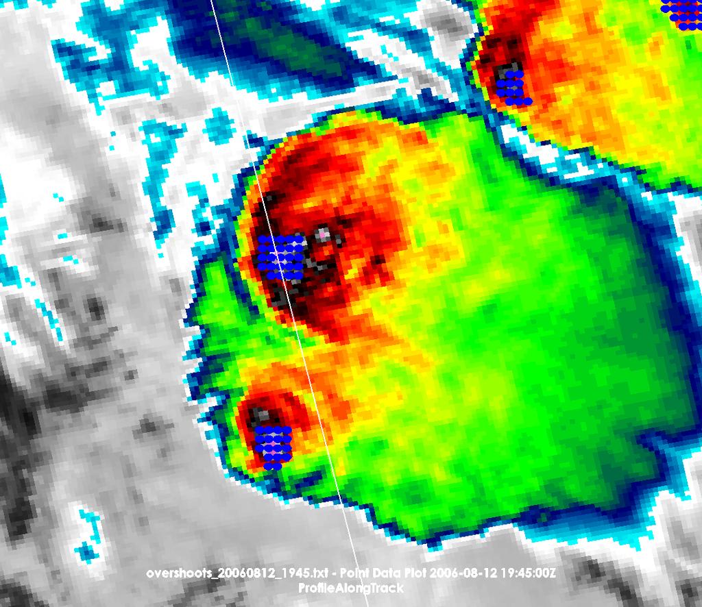
10 Objective Overshooting Top Detections

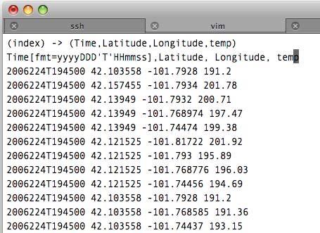
11 Ideal Multisensor Data Plot Using MATLAB We used 6 input files and ~175 lines of matlab code to generate this plot which shows overshooting top detections and MODIS brightness temperature transects along the CloudSat and CALIPSO overpass from the previously shown case McIDAS-V would need to have capability to share multiple transects and cross-sections, display overshoot detection point data on this transect display, and support for Level 2 CALIPSO tropopause (from GEOS-5 NWP) and cloud top height. User adjustments to axis tick mark label frequency, axis labels (and font type/size), and a plot legend editor would also be required


12 1 km MODIS IR Window on GOES-12 Projection 4 km GOES-12 IR Window


13 MODIS 0.25 km Visible with OT Detections, Anvil BT Couplets, andtime Matched Severe Hail Reports 1 km WV-IR Window BT Difference This example shows that the UW-CIMSS overshooting top detection method produces fewer false alarms than the well-documented WV-IR Window BT difference OT detection technique MODIS 1 km IR Window BT with OT Detections, Anvil BT Couplets, andtime Matched Severe Hail Reports UW-CIMSS anvil BT couplet (i.e. enhanced-v ) detections correlate well with storms producing severe hail


14 GOES-12 with Radar Reflectivity, Lightning, and Aviation Turbulence UW-CIMSS (in collaboration with NCAR RAL and UAH) is studying the relationship between satellite observations of convection, ground-based lightning, and aviation turbulence to develop objective satellite feature detection algorithms that can help improve aviation safety GOES-12 IR Window Imagery Nexrad 1 km Composite Reflectivity Mosaic NLDN Cloud-to- Ground Lightning United Airlines Objective In-situ Turbulence Data Blue=Non-Turbulent Green=Turbulence
 developed at OU- CIMMS and NSSL to monitor time trends in cloud top temperature which can be")

15 Objective Satellite-based Thunderstorm Development Forecasting UW-CIMSS is using cloud object detection software (WDSS-II) developed at OU- CIMMS and NSSL to monitor time trends in cloud top temperature which can be used to objectively forecast future thunderstorm development GOES-12 IR Window BT WDSS-II Cloud Object Identification Colored by the Mean Object IR Window BT White Arrows: 2-D Object Motion Field, Arrow Length Proportional to Speed
16 Recipe For a McIDAS-V Friendly NetCDF File Though our files are not CF-compliant, the following structure will display properly in McIDAS-V
17 Benefits of McIDAS-V to UW-CIMSS Thunderstorm Research The ability to combine 2-D satellite imagery, 2-D space-based vertical profiles, and 3-D cloud fields to better understand storm vertical structure and/or time evolution Support for a diverse array of datasets...ability to display user-generated products and point validation data in combination with traditional satellite/radar imagery Comprehensive capability for multispectral image analysis via Hydra tools Automatic navigation of datasets of varying spatial resolution Powerful utility to time sync and animate data of varying temporal resolution The little things important for publication and presentation quality graphics 1)Multiple animation options, Quicktime.mov,.avi, Animated.gif 2)Ability to design new color enhancements and easily adjust data display ranges 3)Plot annotations with text, arrows, and shapes 4)Options for easy color bar display with adjustable font size/type for labelling
McIDAS Activities Within The NASA Langley Research Center Clouds And Radiation Group
 McIDAS Activities Within The NASA Langley Research Center Clouds And Radiation Group Kristopher Bedka Science Systems and Applications Inc @ NASA LaRC In Collaboration With (in alphabetical order) J. K.
Satellite-based Convection Nowcasting and Aviation Turbulence Applications
 Satellite-based Convection Nowcasting and Aviation Turbulence Applications Kristopher Bedka Cooperative Institute for Meteorological Satellite Studies (CIMSS), University of Wisconsin-Madison In collaboration
SATELLITE SIGNATURES ASSOCIATED WITH SIGNIFICANT CONVECTIVELY-INDUCED TURBULENCE EVENTS
 SATELLITE SIGNATURES ASSOCIATED WITH SIGNIFICANT CONVECTIVELY-INDUCED TURBULENCE EVENTS Kristopher Bedka 1, Wayne Feltz 1, John Mecikalski 2, Robert Sharman 3, Annelise Lenz 1, and Jordan Gerth 1 1 Cooperative
Objective Satellite-Based Detection of Overshooting Tops Using Infrared Window Channel Brightness Temperature Gradients
 VOLUME 49 J O U R N A L O F A P P L I E D M E T E O R O L O G Y A N D C L I M A T O L O G Y FEBRUARY 2010 Objective Satellite-Based Detection of Overshooting Tops Using Infrared Window Channel Brightness
Detection of convective overshooting tops using Himawari-8 AHI, CloudSat CPR, and CALIPSO data
 Detection of convective overshooting tops using Himawari-8 AHI, CloudSat CPR, and CALIPSO data Miae Kim¹, Jungho Im¹, Seonyoung Park¹ ¹Ulsan National Institute of Science and Technology (UNIST), South
Validation of Satellite-Based Objective Overshooting Cloud-Top Detection Methods Using CloudSat Cloud Profiling Radar Observations
 OCTOBER 2012 B E D K A E T A L. 1811 Validation of Satellite-Based Objective Overshooting Cloud-Top Detection Methods Using CloudSat Cloud Profiling Radar Observations KRISTOPHER M. BEDKA Science Systems
McIDAS ACTIVITIES AT NASA- LANGLEY RESEARCH CENTER
 McIDAS ACTIVITIES AT NASA- LANGLEY RESEARCH CENTER 1) McIDAS-X 2) McIDAS-V Douglas Spangenberg, SSAI, Hampton, VA Kris Bedka, NASA LaRC, Hampton, VA Bill Smith Jr., NASA LaRC, Hampton, VA Rabi Palikonda,
Near Real-time Cloud Classification, Mesoscale Winds, and Convective Initiation Fields from MSG Data
 Near Real-time Cloud Classification, Mesoscale Winds, and Convective Initiation Fields from MSG Data Wayne Feltz *, J. Mecikalski, and K. Bedka * Cooperative Institute of Meteorological Satellite Studies
ABI and AIRS Retrievals in McIDAS-V
 ABI and AIRS Retrievals in McIDAS-V Kaba Bah Content Introduction to McIDAS V Introduction to GOES R ABI Visualize simulated ABI using McIDAS V Analyze simulated ABI using McIDAS V Introduction to AIRS
P5.7 THE ADVANCED SATELLITE AVIATION WEATHER PRODUCTS (ASAP) INITIATIVE: PHASE I EFFORTS AT THE UNIVERSITY OF ALABAMA IN HUNTSVILLE
 INITIATIVE: PHASE I EFFORTS AT THE UNIVERSITY OF ALABAMA IN HUNTSVILLE") P5.7 THE ADVANCED SATELLITE AVIATION WEATHER PRODUCTS (ASAP) INITIATIVE: PHASE I EFFORTS AT THE UNIVERSITY OF ALABAMA IN HUNTSVILLE John R. Mecikalski #1, Todd A. Berendes #, U. S. Nair #, Wayne F. Feltz*,
P5.7 THE ADVANCED SATELLITE AVIATION WEATHER PRODUCTS (ASAP) INITIATIVE: PHASE I EFFORTS AT THE UNIVERSITY OF ALABAMA IN HUNTSVILLE John R. Mecikalski #1, Todd A. Berendes #, U. S. Nair #, Wayne F. Feltz*,
SATELLITE MONITORING OF THE CONVECTIVE STORMS
 SATELLITE MONITORING OF THE CONVECTIVE STORMS FORECASTERS POINT OF VIEW Michaela Valachová, EUMETSAT Workshop at ECMWF User Meeting Reading, 13 June 2017 Central Forecasting Office, Prague michaela.valachova@chmi.cz
The Advanced Satellite Aviation-weather Products (ASAP) initiative at the University of Wisconsin - CIMSS
 initiative at the University of Wisconsin - CIMSS") P3.3 The Advanced Satellite Aviation-weather Products (ASAP) initiative at the University of Wisconsin - CIMSS Wayne F. Feltz*, John R. Mecikalski #, John J. Murray +, David B. Johnson -, Kristopher Bedka*,
P3.3 The Advanced Satellite Aviation-weather Products (ASAP) initiative at the University of Wisconsin - CIMSS Wayne F. Feltz*, John R. Mecikalski #, John J. Murray +, David B. Johnson -, Kristopher Bedka*,
AOMSUC-6 Training Event
 Effective use of high temporal and spatial resolution Himawari-8 data AOMSUC-6 Training Event Bodo Zeschke Australian Bureau of Meteorology Training Centre Australian VLab Centre of Excellence Content
Nowcasting thunderstorms for aeronautical end-users
 Nowcasting thunderstorms for aeronautical end-users Jean-Marc Moisselin Météo-France, Nowcasting Department co-authors: Céline Jauffret (Météo-France) Overview Introduction SAT RADAR NWP image crédit:
EUMETSAT/15 TH AMS SATELLITE CONFERENCE
 EUMETSAT/15 TH AMS SATELLITE CONFERENCE Toward An Objective Enhanced-V Detection Algorithm University of Wisconsin-Madison/CIMSS Jason Brunner, Wayne Feltz, John Moses, Robert Rabin, and Steven Ackerman
Satellite-Derived Aviation Hazard Products at the University of Wisconsin: Convection, Turbulence, Volcanic Ash, and Winds
 5.08 Satellite-Derived Aviation Hazard Products at the University of Wisconsin: Convection, Turbulence, Volcanic Ash, and Winds Wayne F. Feltz*, John R. Mecikalski #, John J. Murray +, David B. Johnson
The next generation in weather radar software.
 The next generation in weather radar software. PUBLISHED BY Vaisala Oyj Phone (int.): +358 9 8949 1 P.O. Box 26 Fax: +358 9 8949 2227 FI-00421 Helsinki Finland Try IRIS Focus at iris.vaisala.com. Vaisala
Improving real time observation and nowcasting RDT. E de Coning, M Gijben, B Maseko and L van Hemert Nowcasting and Very Short Range Forecasting
 Improving real time observation and nowcasting RDT E de Coning, M Gijben, B Maseko and L van Hemert Nowcasting and Very Short Range Forecasting Introduction Satellite Application Facilities (SAFs) are
Rapidly Developing Thunderstorm (RDT)
") Rapidly Developing Thunderstorm (RDT) Jean-Marc Moisselin, Frédéric Autones Météo-France Nowcasting Department 42, av. Gaspard Coriolis 31057 Toulouse France jean-marc.moisselin@meteo.fr EUMETRAIN Convection
Rapidly Developing Thunderstorm (RDT) Jean-Marc Moisselin, Frédéric Autones Météo-France Nowcasting Department 42, av. Gaspard Coriolis 31057 Toulouse France jean-marc.moisselin@meteo.fr EUMETRAIN Convection
Remote Sensing in Meteorology: Satellites and Radar. AT 351 Lab 10 April 2, Remote Sensing
 Remote Sensing in Meteorology: Satellites and Radar AT 351 Lab 10 April 2, 2008 Remote Sensing Remote sensing is gathering information about something without being in physical contact with it typically
OVERSHOOTING TOPS CHARACTERISTICS AND PROPERTIES
 OVERSHOOTING TOPS CHARACTERISTICS AND PROPERTIES Michaela Valachová 1,2, Martin Setvák 2, Jindřich Šťástka 1,2 1 Charles University in Prague, Faculty of Mathematics and Physics, Department of Meteorology
Usage of McIDAS V with GOES R AWG products
 McIDAS User Group Meeting, October 25-27, 2010, Madison, WI Usage of McIDAS V with GOES R AWG products William Straka III UW/CIMSS Madison, Wisconsin, USA With help from Tom Rink (CIMSS/), Tom Achtor (CIMSS/),
Data Format and Visualization Agenda
 Data Format and Visualization Agenda- 7.2.2 ET-SUP-8 (14.04.2014) Suman Goyal, Satellite Meteorology Division, India Meteorological Department, Suman_goyal61@yahoo.co.in Visualization Methods The satellite
McIDAS support of Suomi-NPP /JPSS and GOES-R L2
 McIDAS support of Suomi-NPP /JPSS and GOES-R L2 William Straka III 1 Tommy Jasmin 1, Bob Carp 1 1 Cooperative Institute for Meteorological Satellite Studies, Space Science and Engineering Center, University
Atmospheric Motion Vectors (AMVs) and their forecasting significance
 and their forecasting significance") Atmospheric Motion Vectors (AMVs) and their forecasting significance Vijay Garg M.M. College, Modi Nagar, Ghaziabad, Uttar Pradesh R.K. Giri Meteorological Center India Meteorological Department, Patna-14
Atmospheric Motion Vectors (AMVs) and their forecasting significance Vijay Garg M.M. College, Modi Nagar, Ghaziabad, Uttar Pradesh R.K. Giri Meteorological Center India Meteorological Department, Patna-14
Preparing for NOAA s Next Generation GOES-R & JPSS
 Preparing for NOAA s Next Generation GOES-R & JPSS Mark Paese Deputy Assistant Administrator NOAA Environmental Satellite & Information Service (NESDIS) WMO Cg-17: Ensuring User Readiness for New Generation
Tool for Storm Analysis Using Multiple Data Sets
 Tool for Storm Analysis Using Multiple Data Sets Robert M. Rabin 1,2 and Tom Whittaker 2 1 NOAA/National Severe Storms Laboratory, Norman OK 73069, USA 2 Cooperative Institute for Meteorological Satellite
NOAA Research and Development Supporting NextGen. Darien Davis NOAA Office of Oceanic and Atmospheric Research June 22, 2009
 NOAA Research and Development Supporting NextGen Darien Davis Darien.l.davis@noaa.gov NOAA Office of Oceanic and Atmospheric Research June 22, 2009 FAA/NOAA Coordination Developing an integrated science
MSGVIEW: AN OPERATIONAL AND TRAINING TOOL TO PROCESS, ANALYZE AND VISUALIZATION OF MSG SEVIRI DATA
 MSGVIEW: AN OPERATIONAL AND TRAINING TOOL TO PROCESS, ANALYZE AND VISUALIZATION OF MSG SEVIRI DATA Aydın Gürol Ertürk Turkish State Meteorological Service, Remote Sensing Division, CC 401, Kalaba Ankara,
Lecture 4b: Meteorological Satellites and Instruments. Acknowledgement: Dr. S. Kidder at Colorado State Univ.
 Lecture 4b: Meteorological Satellites and Instruments Acknowledgement: Dr. S. Kidder at Colorado State Univ. US Geostationary satellites - GOES (Geostationary Operational Environmental Satellites) US
U. S. Contributions to COPS: Satellite-estimated Convective Initiation
 U. S. Contributions to COPS: Satellite-estimated Convective Initiation John R. Mecikalski 1, Kristopher M. Bedka 2 Simon J. Paech 1, Todd A. Berendes 1, Wayne M. Mackenzie 1 1 Atmospheric Science Department
Meteorological Satellite Image Interpretations, Part III. Acknowledgement: Dr. S. Kidder at Colorado State Univ.
 Meteorological Satellite Image Interpretations, Part III Acknowledgement: Dr. S. Kidder at Colorado State Univ. Dates EAS417 Topics Jan 30 Introduction & Matlab tutorial Feb 1 Satellite orbits & navigation
WMO Aeronautical Meteorology Scientific Conference 2017
 Session 1 Science underpinning meteorological observations, forecasts, advisories and warnings 1.6 Observation, nowcast and forecast of future needs 1.6.1 Advances in observing methods and use of observations
Cooperative Institute for Meteorological Satellite Studies, University of Wisconsin Madison (2)
") P8.3 STATISTICAL RELATIONSHIPS BETWEEN SATELLITE-DERIVED MESOSCALE ATMOSPHERIC MOTION VECTORS, RAWINSONDES, AND NOAA WIND PROFILER NETWORK OBSERVATIONS Kristopher Bedka (1) *, Wayne F. Feltz (1), John
P8.3 STATISTICAL RELATIONSHIPS BETWEEN SATELLITE-DERIVED MESOSCALE ATMOSPHERIC MOTION VECTORS, RAWINSONDES, AND NOAA WIND PROFILER NETWORK OBSERVATIONS Kristopher Bedka (1) *, Wayne F. Feltz (1), John
Hail nowcast exploiting radar and satellite observations
 Federal Department of Home Affairs FDHA Federal Office of Meteorology and Climatology MeteoSwiss Hail nowcast exploiting radar and satellite observations Ulrich Hamann, Elena Leonarduzzi, Kristopher Bedka,
SUPER-RAPID SCAN SATELLITE IMAGERY ANALYSIS OF TWO HAILSTORMS SAMPLED BY HAILSTONE
 SUPER-RAPID SCAN SATELLITE IMAGERY ANALYSIS OF TWO HAILSTORMS SAMPLED BY HAILSTONE Jennifer M. Laflin* and Scott F. Blair NOAA/NWS Kansas City/Pleasant Hill, Missouri Chad Gravelle NOAA/NWS Operations
Development of a System for Quantitatively Analyzing Volcanic Clouds
 Development of a System for Quantitatively Analyzing Volcanic Clouds Michael Pavolonis (NOAA/NESDIS/STAR) Justin Sieglaff and John Cintineo (UW-CIMSS) Marco Fulle - www.stromboli.net 2 nd IUGG-WMO Workshop
Advances in Weather Technology
 Advances in Weather Technology Dr. G. Brant Foote National Center for Atmospheric Research 16 May 2001 NCAR Research Results in Aviation Weather Built on the foundation of the nation s long-standing investment
Satellite-derived Mountain Wave Turbulence Interest Field Detection
 Satellite-derived Mountain Wave Turbulence Interest Field Detection Wayne F. Feltz, Jason Otkin, Kristopher Bedka, and Anthony Wimmers Cooperative Institute for Meteorological Satellite Studies (CIMSS),
Cloud Occurrence from the level 2B CloudSat- CALIPSO Cloud Mask Data
 Cloud Occurrence from the level 2B CloudSat- CALIPSO Cloud Mask Data Jay Mace and Qiuqing Zhang 1. Briefly introduce Geoprof-Lidar Product 2. Examine the vertical and horizontal distribution of cloud occurrence
Nowcasting of Severe Weather from Satellite Images (for Southern
 Nowcasting of Severe Weather from Satellite Images (for Southern Europe) Petra Mikuš Jurković Forecasting/ nowcasting of convective storms NWP models cannot well predict the exact location and intesity
1. FY10 GOES-R3 Project Proposal Title Page
 1. FY10 GOES-R3 Project Proposal Title Page Title: Transitioning GOES-Based Nowcasting Capability into the GOES-R Era Project Type: Product development Proposal Status: Renewal Duration: 3 years FY08 -
Real-time Generation of. River Ice and Flood Products Derived from VIIRS Imagery
 Real-time Generation of 1 River Ice and Flood Products Derived from VIIRS Imagery David Santek 1, S. Li 2, N. Chaoch 3, J. Gerth 1, J. Hoffman 1, P. Alabi 3 1 University of Wisconsin-Madison/SSEC/CIMSS
Regional Hazardous Weather Advisory Centres (RHWACs)
") Regional Hazardous Weather Advisory Centres (RHWACs) The following outlines the criteria for the selection of RHWACs based on operational and functional requirements 1. Basic Principles The RHWAC must:
Regional Hazardous Weather Advisory Centres (RHWACs) The following outlines the criteria for the selection of RHWACs based on operational and functional requirements 1. Basic Principles The RHWAC must:
COLD-RING AND COLD-U/V SHAPED STORMS
 MARTIN SETVÁK setvak@chmi.cz Czech Hydrometeorological Institute, Prague COLD-RING AND COLD-U/V SHAPED STORMS Version : 18 May 2009 What are the cold-ring and cold-u/v shaped storms? Appearance and terminology
Remote Sensing Seminar 8 June 2007 Benevento, Italy. Lab 5 SEVIRI and MODIS Clouds and Fires
 Remote Sensing Seminar 8 June 2007 Benevento, Italy Lab 5 SEVIRI and MODIS Clouds and Fires Table: SEVIRI Channel Number, Wavelength (µm), and Primary Application Reflective Bands 1,2 0.635, 0.81 land/cld
WMO Aeronautical Meteorology Scientific Conference 2017
 Session 2 Integration, use cases, fitness for purpose and service delivery 2.4 Trajectory-based operations (TBO), flight planning and user-preferred routing The Remote Oceanic Meteorology Information Operational
CSPP Geo. CSPP/IMAPP Users Group Meeting 2015 Darmstadt, Germany 15 April 2015
 CSPP Geo Graeme Martin, Liam Gumley, Nick Bearson, Jessica Braun, Geoff Cureton, Ray Garcia, Tommy Jasmin, Scott Mindock, Kathy Strabala University of Wisconsin Madison, Space Science & Engineering Center
From ITPP, IAPP, IMAPP to CSPP Supporting Direct Broadcast Users Over Three Decades
 From ITPP, IAPP, IMAPP to CSPP Supporting Direct Broadcast Users Over Three Decades Allen Huang PI of IMAPP & CSPP-LEO allenh@ssec.wisc.edu Space Science & Engineering Center (SSEC) University of Wisconsin-Madison
Your Source for Global Aviation Forecasts
 Your Source for Global Aviation Forecasts (831) 238-5054 100 Sky Park Drive Monterey, CA 93940 Weather4Cast.com Live Weather Data Feeds Weather4Cast.com provides Live Aviation Weather Data Feeds formatted
Weather Technology in the Cockpit (WTIC) Shortfall Analysis of Weather Information in Remote Airspace Friends and Partners of Aviation Weather Summer
 Shortfall Analysis of Weather Information in Remote Airspace Friends and Partners of Aviation Weather Summer") Weather Technology in the Cockpit (WTIC) Shortfall Analysis of Weather Information in Remote Airspace Friends and Partners of Aviation Weather Summer Meeting Tim Myers Metron Aviation August 26, 2015 2
Weather Technology in the Cockpit (WTIC) Shortfall Analysis of Weather Information in Remote Airspace Friends and Partners of Aviation Weather Summer Meeting Tim Myers Metron Aviation August 26, 2015 2
Future GOES (XGOHI, GOES-13/O/P, GOES-R+)
") Future GOES (XGOHI, GOES-13/O/P, GOES-R+) Timothy J. Schmit NOAA/NESDIS/Satellite Applications and Research Advanced Satellite Products Branch (ASPB) Madison, WI And many others MUG Meeting October 16,
Future GOES (XGOHI, GOES-13/O/P, GOES-R+) Timothy J. Schmit NOAA/NESDIS/Satellite Applications and Research Advanced Satellite Products Branch (ASPB) Madison, WI And many others MUG Meeting October 16,
The next generation in weather radar software.
 The next generation in weather radar software. PUBLISHED BY Vaisala Oyj Phone (int.): +358 9 8949 1 P.O. Box 26 Fax: +358 9 8949 2227 FI-00421 Helsinki Finland Try IRIS Focus at iris.vaisala.com. Vaisala
Use of radar to detect weather
 2 April 2007 Welcome to the RAP Advisory Panel Meeting Use of radar to detect weather G. Brant Foote Brant Director Foote Rita Roberts Roelof Bruintjes Research Applications Program Radar principles Radio
Guidance on Aeronautical Meteorological Observer Competency Standards
 Guidance on Aeronautical Meteorological Observer Competency Standards The following guidance is supplementary to the AMP competency Standards endorsed by Cg-16 in Geneva in May 2011. Format of the Descriptions
17 November Welcome from SSEC. Hank Revercomb, SSEC Director. University of Wisconsin - Madison Space Science and Engineering Center (SSEC)
") 17 November 2012 Welcome from SSEC Hank Revercomb, SSEC Director University of Wisconsin - Madison Space Science and Engineering Center (SSEC) McIDAS Users Group (MUG) Meeting South Union, 8 July 2015
17 November 2012 Welcome from SSEC Hank Revercomb, SSEC Director University of Wisconsin - Madison Space Science and Engineering Center (SSEC) McIDAS Users Group (MUG) Meeting South Union, 8 July 2015
The NASA Short-term Prediction Research and Transition (SPoRT) Center:
 Center:") The NASA Short-term Prediction Research and Transition (SPoRT) Center: Opportunities for Collaboration in the Great Lakes Region Andrew Molthan NASA Marshall Space Flight Center, Huntsville, AL andrew.molthan@nasa.gov
The NASA Short-term Prediction Research and Transition (SPoRT) Center: Opportunities for Collaboration in the Great Lakes Region Andrew Molthan NASA Marshall Space Flight Center, Huntsville, AL andrew.molthan@nasa.gov
FAA Weather Research Plans
 FAA Weather Research Plans Presented to: Friends /Partners in Aviation Weather Vision Forum By: Ray Moy FAA Aviation Weather Office Date: Aviation Weather Research Program (AWRP) Purpose: Applied Research
The ABI (Advanced Baseline Imager) on the GOES-R series
 on the GOES-R series") The ABI (Advanced Baseline Imager) on the GOES-R series Timothy J. Schmit NOAA/NESDIS/Satellite Applications and Research Advanced Satellite Products Branch (ASPB) Kaba Bah, Mathew M. Gunshor, Jun Li,
The ABI (Advanced Baseline Imager) on the GOES-R series Timothy J. Schmit NOAA/NESDIS/Satellite Applications and Research Advanced Satellite Products Branch (ASPB) Kaba Bah, Mathew M. Gunshor, Jun Li,
Regional Hazardous Weather Advisory Centres (RHWACs)
") Regional Hazardous Weather Advisory Centres (RHWACs) The following outlines the criteria for the selection of RHWACs based on operational and functional requirements 1. Basic Principles The RHWAC must:
Regional Hazardous Weather Advisory Centres (RHWACs) The following outlines the criteria for the selection of RHWACs based on operational and functional requirements 1. Basic Principles The RHWAC must:
CLAVR-x is the Clouds from AVHRR Extended Processing System. Responsible for AVHRR cloud products and other products at various times.
 CLAVR-x in CSPP Andrew Heidinger, NOAA/NESDIS/STAR, Madison WI Nick Bearson, SSEC, Madison, WI Denis Botambekov, CIMSS, Madison, WI Andi Walther, CIMSS, Madison, WI William Straka III, CIMSS, Madison,
Accessing satellite data via Apps, Web Map Servers, and the GOES-R Education Proving Ground. Margaret Mooney CIMSS/SSEC, UW-Madison
 Accessing satellite data via Apps, Web Map Servers, and the GOES-R Education Proving Ground Margaret Mooney CIMSS/SSEC, UW-Madison CIMSS & SSEC at the UW-Madison SSEC Data Center Incoming Data May, 2015
LARGE-SCALE WRF-SIMULATED PROXY ATMOSPHERIC PROFILE DATASETS USED TO SUPPORT GOES-R RESEARCH ACTIVITIES
 LARGE-SCALE WRF-SIMULATED PROXY ATMOSPHERIC PROFILE DATASETS USED TO SUPPORT GOES-R RESEARCH ACTIVITIES Jason Otkin, Hung-Lung Huang, Tom Greenwald, Erik Olson, and Justin Sieglaff Cooperative Institute
Cooperative Institute for Meteorological Satellite Studies University of Wisconsin - Madison
 1 Content Introduction Visualize Analyze Validate/ Deep-dive Summary 2 Introduction. McIDAS-V is a powerful and versatile visualization and data analysis software. It is Java based, open source and freely
McIDAS-X Software Development and Demonstration. PDA Animated Weather (PAW) Status by Russ Dengel. Dave Santek and Jay Heinzelman.
 Status by Russ Dengel. Dave Santek and Jay Heinzelman.") McIDAS-X Software Development and Demonstration Dave Santek and Jay Heinzelman 2 June 2009 PDA Animated Weather (PAW) Status by Russ Dengel Overview McIDAS-X 2008, 2009.1 McIDAS-XRD 2008, 2009.1 Software
McIDAS-X Software Development and Demonstration Dave Santek and Jay Heinzelman 2 June 2009 PDA Animated Weather (PAW) Status by Russ Dengel Overview McIDAS-X 2008, 2009.1 McIDAS-XRD 2008, 2009.1 Software
Aviation Hazards: Thunderstorms and Deep Convection
 Aviation Hazards: Thunderstorms and Deep Convection TREND Diagnosis of thunderstorm hazards using imagery Contents Satellite imagery Visible, infrared, water vapour Basic cloud identification Identifying
<Operational nowcasting systems in the framework of the 4-D MeteoCube>
 Background Nowcasting is applicable
EOS Direct Broadcast Real-Time Products for the US National Weather Service
 EOS Direct Broadcast Real-Time Products for the US National Weather Service Liam E. Gumley,, K. Strabala, J. Gerth,, S. Bachmeier, R. Dengel,, S. Dutcher, and J. Robaidek Liam.Gumley@ssec.wisc.edu University
Detection and Monitoring Convective Storms by. Using MSG SEVIRI Image. Aydın Gürol ERTÜRK. Contents
 Detection and Monitoring Convective Storms by 1 Using MSG SEVIRI Image Contents MSGView Software Cold U/V and Ring Shape Storm Tops Case Study, 2nd April 2011 Antalya, Türkiye Conclusion Aydın Gürol ERTÜRK
Jason C. Brunner * Cooperative Institute for Meteorological Satellite Studies (CIMSS)/University of Wisconsin, Madison, Wisconsin
/University of Wisconsin, Madison, Wisconsin") P3.16 A QUANTITATIVE ANALYSIS OF THE ENHANCED-V FEATURE Jason C. Brunner * Cooperative Institute for Meteorological Satellite Studies (CIMSS)/University of Wisconsin, Madison, Wisconsin Steven A. Ackerman
P3.16 A QUANTITATIVE ANALYSIS OF THE ENHANCED-V FEATURE Jason C. Brunner * Cooperative Institute for Meteorological Satellite Studies (CIMSS)/University of Wisconsin, Madison, Wisconsin Steven A. Ackerman
P3.24 EVALUATION OF MODERATE-RESOLUTION IMAGING SPECTRORADIOMETER (MODIS) SHORTWAVE INFRARED BANDS FOR OPTIMUM NIGHTTIME FOG DETECTION
 SHORTWAVE INFRARED BANDS FOR OPTIMUM NIGHTTIME FOG DETECTION") P3.24 EVALUATION OF MODERATE-RESOLUTION IMAGING SPECTRORADIOMETER (MODIS) SHORTWAVE INFRARED BANDS FOR OPTIMUM NIGHTTIME FOG DETECTION 1. INTRODUCTION Gary P. Ellrod * NOAA/NESDIS/ORA Camp Springs, MD
P3.24 EVALUATION OF MODERATE-RESOLUTION IMAGING SPECTRORADIOMETER (MODIS) SHORTWAVE INFRARED BANDS FOR OPTIMUM NIGHTTIME FOG DETECTION 1. INTRODUCTION Gary P. Ellrod * NOAA/NESDIS/ORA Camp Springs, MD
ON LINE ARCHIVE OF STORM PENETRATING DATA
 ON LINE ARCHIVE OF STORM PENETRATING DATA Matthew Beals, Donna V. Kliche, and Andrew G. Detwiler Institute of Atmospheric Sciences, South Dakota School of Mines and Technology, Rapid City, SD Steve Williams
Weather Technology in the Cockpit (WTIC) Program Program Update. Friends/Partners of Aviation Weather (FPAW) November 2, 2016
 Program Program Update. Friends/Partners of Aviation Weather (FPAW) November 2, 2016") Weather Technology in the Cockpit (WTIC) Program Program Update Friends/Partners of Aviation Weather (FPAW) November 2, 2016 Presented by Gary Pokodner, WTIC Program Manager Phone: 202.267.2786 Email:
Weather Technology in the Cockpit (WTIC) Program Program Update Friends/Partners of Aviation Weather (FPAW) November 2, 2016 Presented by Gary Pokodner, WTIC Program Manager Phone: 202.267.2786 Email:
How to display RGB imagery by SATAID
 How to display RGB imagery by SATAID Akihiro SHIMIZU Meteorological Satellite Center (MSC), Japan Meteorological Agency (JMA) Ver. 2015110500 RGB imagery on SATAID SATAID software has a function of overlapping
A Satellite-Based Convective Cloud Object Tracking and Multipurpose Data Fusion Tool with Application to Developing Convection
 510 J O U R N A L O F A T M O S P H E R I C A N D O C E A N I C T E C H N O L O G Y VOLUME 30 A Satellite-Based Convective Cloud Object Tracking and Multipurpose Data Fusion Tool with Application to Developing
Combining Polar Hyper-spectral and Geostationary Multi-spectral Sounding Data A Method to Optimize Sounding Spatial and Temporal Resolution
 Combining Polar Hyper-spectral and Geostationary Multi-spectral Sounding Data A Method to Optimize Sounding Spatial and Temporal Resolution W. L. Smith 1,2, E. Weisz 1, and J. McNabb 2 1 University of
THE FEASIBILITY OF EXTRACTING LOWLEVEL WIND BY TRACING LOW LEVEL MOISTURE OBSERVED IN IR IMAGERY OVER CLOUD FREE OCEAN AREA IN THE TROPICS
 THE FEASIBILITY OF EXTRACTING LOWLEVEL WIND BY TRACING LOW LEVEL MOISTURE OBSERVED IN IR IMAGERY OVER CLOUD FREE OCEAN AREA IN THE TROPICS Toshiro Ihoue and Tetsuo Nakazawa Meteorological Research Institute
REPORT ON THE ACTIVITIES OF THE EUMETSAT-ESSL CONVECTION WORKING GROUP
 REPORT ON THE ACTIVITIES OF THE EUMETSAT-ESSL CONVECTION WORKING GROUP Marianne König EUMETSAT, Eumetsat Allee 1, 64295 Darmstadt, Germany Abstract The focus of the Convection Working Group is to have
OCND Convective Cloud Heights
 OCND Convective Cloud Heights NRL Satellite Meteorological Applications Monterey, CA Outline: I. Background II. Outline of Method a. North/South Domains b. Strengths/Weaknesses III. Protocols of the Aviation
Judit Kerényi. OMSZ - Hungarian Meteorological Service, Budapest, Hungary. H-1525 Budapest, P.O.Box 38, Hungary.
 SATELLITE-DERIVED PRECIPITATION ESTIMATIONS DEVELOPED BY THE HYDROLOGY SAF PROJECT CASE STUDIES FOR THE INVESTIGATION OF THEIR ACCURACY AND FEATURES IN HUNGARY Judit Kerényi OMSZ - Hungarian Meteorological
Applications of future GEO advanced IR sounder for high impact weather forecasting demonstration with regional OSSE
 Applications of future GEO advanced IR sounder for high impact weather forecasting demonstration with regional OSSE Jun Li @, Tim Schmit &, Zhenglong Li @, Feng Zhu @*, Pei Wang @*, Agnes Lim @, and Robert
The UW-CIMSS Advanced Dvorak Technique (ADT) : An Automated IR Method to Estimate Tropical Cyclone Intensity
 : An Automated IR Method to Estimate Tropical Cyclone Intensity") The UW-CIMSS Advanced (ADT) : An Automated IR Method to Estimate Tropical Cyclone Intensity Timothy Olander and Christopher Velden University of Wisconsin Madison, USA Cooperative Institute for Meteorological
The UW-CIMSS Advanced (ADT) : An Automated IR Method to Estimate Tropical Cyclone Intensity Timothy Olander and Christopher Velden University of Wisconsin Madison, USA Cooperative Institute for Meteorological
RGB Experts and Developers Workshop 2017 Tokyo, Japan
 "Application of the Sandwich Product and variations to this as used by Australian Forecasters and as presented during training at the Australian VLab Centre of Excellence". RGB Experts and Developers Workshop
Unidata: An Overview. Tom Yoksas. Unidata Program Center / UCAR Boulder, Colorado USA
 Unidata: An Overview Tom Yoksas Unidata Program Center / UCAR Boulder, Colorado USA http://www.unidata.ucar.edu Unidata - Principle Activities Providing Tools to visualize, analyze, organize, receive,
Himawari-8 BUFR Development for Winds Processing and Radiances - Packaging for Algorithm Integration Team (AIT)
") Sandy Supplemental Grant Recipient Quarterly Progress Report Himawari-8 BUFR Development for Winds Processing and Radiances - Packaging for Algorithm Integration Team (AIT) Award Number: NA14NWS4830052
Sandy Supplemental Grant Recipient Quarterly Progress Report Himawari-8 BUFR Development for Winds Processing and Radiances - Packaging for Algorithm Integration Team (AIT) Award Number: NA14NWS4830052
Turbulence Avoidance Technologies
 Turbulence Avoidance Technologies The information contained herein is advisory only in nature. Modification Date: 01NOV2016 Revision: 0.0 Operations Scope: ALL AIRCRACT Briefing Owners: Tenille Cromwell
1. Open IDV. There is a desktop link, choose version 3.0u1 or 3.0u2. It can take a few minutes to open.
 Page 1 Objectives: Become familiar with using a software package (IDV) to view satellite images Understand the differences between Visible, IR, and Microwave Imagery Observe the influence of dry air and
Evaluation of CIT Avoidance Guidelines. Turbulence PDT Task FY 2005 Year-End Progress Report
 Evaluation of CIT Avoidance Guidelines Turbulence PDT Task 05.7.3.13 FY 2005 Year-End Progress Report Deliverable 05.7.3.13.E1 Submitted by The National Center for Atmospheric Research Introduction In
Early detection of thunderstorms using satellite, radar and
 Federal Department of Home of Home Affairs Affairs FDHA FDHA Federal Office of of Meteorology and and Climatology MeteoSwiss Early detection of thunderstorms using satellite, radar and Observing convection
SAFNWC/MSG SEVIRI CLOUD PRODUCTS
 SAFNWC/MSG SEVIRI CLOUD PRODUCTS M. Derrien and H. Le Gléau Météo-France / DP / Centre de Météorologie Spatiale BP 147 22302 Lannion. France ABSTRACT Within the SAF in support to Nowcasting and Very Short
Jun Mitch Goldberg %, Pei Timothy J. Schmit &, Jinlong Zhenglong and Agnes
 Progress on the assimilation of advanced IR sounder radiances in cloudy skies Jun Li @, Mitch Goldberg %, Pei Wang @#, Timothy J. Schmit &, Jinlong Li @, Zhenglong Li @, and Agnes Lim @ @CIMSS, University
NOWCASTING PRODUCTS BASED ON MTSAT-1R RAPID SCAN OBSERVATION. In response to CGMS Action 38.33
 CGMS-39, JMA-WP-08 Prepared by JMA Agenda Item: G.II/8 Discussed in WG II NOWCASTING PRODUCTS BASED ON MTSAT-1R RAPID SCAN OBSERVATION In response to CGMS Action 38.33 This document reports on JMA s MTSAT-1R
Multi Radar Multi Sensor NextGen Weather Program. Presentation materials sourced from: Ken Howard HydroMet Research Group NSSL Warning R&D Division
 Multi Radar Multi Sensor NextGen Weather Program Presentation materials sourced from: Ken Howard HydroMet Research Group NSSL Warning R&D Division What is Multiple Radar Multi Sensor System () is the world
Introduction of the Hyperspectral Environmental Suite (HES) on GOES-R and beyond
 on GOES-R and beyond") Introduction of the Hyperspectral Environmental Suite (HES) on GOES-R and beyond Timothy J. Schmit SaTellite Applications and Research (STAR) Advanced Satellite Products Team (ASPT) Presented by Jun Li
Introduction of the Hyperspectral Environmental Suite (HES) on GOES-R and beyond Timothy J. Schmit SaTellite Applications and Research (STAR) Advanced Satellite Products Team (ASPT) Presented by Jun Li
WMO Coordination Group on Satellite Data Requirements for Region III and IV Sept 5-8, 2016 Willemstad, Curaçao
 WMO Coordination Group on Satellite Data Requirements for Region III and IV Sept 5-8, 2016 Willemstad, Curaçao 1. Current Satellite Reception 2. Preparation for Next-Gen GOES-R JPSS 3. Satellite Data Applications
Which AMVs for which model? Chairs: Mary Forsythe, Roger Randriamampianina IWW14, 24 April 2018
 Which AMVs for which model? Chairs: Mary Forsythe, Roger Randriamampianina IWW14, 24 April 2018 Thanks to Regis Borde, EUMETSAT James Cotton, Met Office Javier Garcia-Pereda, NWC SAF Graeme Kelly, Met
WSI Pilotbrief Optima - for ipad
 WSI Pilotbrief Optima - for ipad Anticipate, Visualize & Avoid Hazardous Weather In A Whole New Way The Weather Company, an IBM Business, delivers an ipad-based version of WSI Pilotbrief Optima. This ipad
Advancing Environmental Intelligence via Next-Generation Satellite Observations
 Advancing Environmental Intelligence via Next-Generation Satellite Observations Steven D. Miller Cooperative Institute for Research in the Atmosphere 11 th NOAA/NESDIS CoRP Science Symposium 16 September
Himawari-8 BUFR Development for Winds Processing and Radiances Cloud Mask, Cloud Phase, Cloud Height
 Sandy Supplemental Grant Recipient Quarterly Progress Report Himawari-8 BUFR Development for Winds Processing and Radiances Award Number: NA14NES4830006 The National Oceanic and Atmospheric Administration
CHARACTERISTICS OF EMBEDDED WARM AREAS AND SURROUNDING COLD RINGS AND COLD-US
 CHARACTERISTICS OF EMBEDDED WARM AREAS AND SURROUNDING COLD RINGS AND COLD-US Michaela Radová 1,2, Jindřich Šťástka 1,2, Jakub Seidl 3 (1) Department of Meteorology and Environment Protection, Faculty