Early detection of thunderstorms using satellite, radar and
|
|
|
- Imogene Ellis
- 5 years ago
- Views:
Transcription
1 Federal Department of Home of Home Affairs Affairs FDHA FDHA Federal Office of of Meteorology and and Climatology MeteoSwiss Early detection of thunderstorms using satellite, radar and Observing convection with satellite, radar, and lightning measurements lightning observations Ulrich Hamann, Lorenzo Clementi, Marco Gabella, Urs Germann, Alessandro M. Hering, Luca Nisi and Marco Sassi


2 Meteosat Second Generation Nowcasting strategy of Meteoswiss Swiss Radar Network Wind Hail COALITION Thunderstorm Radar Tracking Vaisala Lightning Sensors Nowcasting tracking and monitoring, statistical learning, turbulence, cloud physics, climatological data, topography, weather types COALITION Lightning Flash Floods
, Nowcasting thunderstorms in the alpine region using a radar based adaptive thresholding scheme.")
3 Hering, A. M., Morel, C., Galli, G., Sénési, S., Ambrosetti, P., and Boscacci, M. (2004), Nowcasting thunderstorms in the alpine region using a radar based adaptive thresholding scheme. Proceedings, Third ERAD Conference, Visby, Sweden,
4 Goals Forecast of Severeness Early detection High POD, low FAR Input Satellite, Radar, NWP, lightning, topography 8 modules for VIL or CTT Forecasting method Pseudo kinetic energy approach COALITION First Generation Nisi, L., Ambrosetti, P. and Clementi, L. (2014), Nowcasting severe convection in the Alpine region: the COALITION approach. Q.J.R. Meteorol. Soc., 140: doi: /qj.2249 Pseudo kinetic energy approach


5 COALITION Second Generation Goals Forecast of Severeness Early detection High POD, low FAR Input Satellite, Radar, NWP, lightning, topography Methods Logistic and Linear Regressions Neural Networks Hamann, U., L. Nisi, L. Clementi, J. Figueras i Ventura, M. Gabella, A. M. Hering, I. Sideris, S. Trefalt, U. Germann, 2015, Observing convection with satellite, radar, and lightning measurements, Symposium EGU General Assembly 2015, Vienna, Austria Hamann, U., L. Nisi, A. Hering, L. Clementi, M. Gabella, U. Germann, 2014 Investigating the typical development of thunderstorms using satellite, radar and lightning observations Eumetsat Conference 2014, Geneva, Switzerland Regression models Neural Networks
, CAPE, instability indices (KI, LI, SHW) Parallax Correction Cloud Top Height Temporal Derivatives consider")
6 COALITION Second Generation MSG SEVIRI observations 12 SEVIRI channels, channel differences, cloud top structure, temporal derivations NWC-SAF products Cloud Mask, Cloud Type, Cloud Phase, Cloud Top Temperature /Height/Pressure, precipitable water (total, boundary, mid, high layer), CAPE, instability indices (KI, LI, SHW) Parallax Correction Cloud Top Height Temporal Derivatives consider Advection SEVIRI High Resolution Winds COSMO CAPE, CIN, precipitable water, tropopause height, frezing level, surface temperature etc. Radar observations maximum reflection, precipitation, CombiPrecip, Probability of Hail, Maximum Expected Hail Size, EchoTops, Hydrometeors Temporal Derivatives consider Advection Radar Winds (Maple) co-located multi sensor database Lightning observations Lightning density, Lightning Current, Polarization, Cloud- Ground Intra-Cloud

7 COALITION Second Generation co-located multi sensor database Logistical Regression Linear Regression or Neural Networks Probability maps for Hail Lighting Precipitation VIL etc. Analysis or Forecast Intensity estimate for Hail Lighting Precipitation VIL etc. Analysis or Forecast
8 MSG SEVIRI observations 12 SEVIRI channels, channel differences, cloud top structure, temporal derivations NWC-SAF products Cloud Mask, Cloud Type, Cloud Phase, Cloud Top Temperature /Height/Pressure, precipitable water (total, boundary, mid, high layer), CAPE, instability indices (KI, LI, SHW) COSMO CAPE, CIN, precipitable water, tropopause height, frezing level, surface temperature etc. COALITION Second Generation Processing with PyTROLL Long term archive 7 summer seasons 18 months of data Parallax Correction Cloud Top Height Location: Switzerland and Alpine Region Temporal Derivatives consider Advection SEVIRI High Resolution Winds co-located multi sensor database 2 months of data in progress Radar observations maximum reflection, precipitation, CombiPrecip, Probability of Hail, Maximum Expected Hail Size, EchoTops, Hydrometeors Long term archive Temporal Derivatives consider Advection Radar Winds (Maple) Long term archive Long term archive Lightning observations Lightning density, Lightning Current, Polarization, Cloud- Ground Intra-Cloud
9 Tests for Convective Initiation Mecikalski, J. R., Wayne M. MacKenzie Jr., Marianne König, and Sam Muller, (2010), Cloud-Top Properties of Growing Cumulus prior to Convective Initiation as Measured by Meteosat Second Generation. Part II: Use of Visible Reflectance. J. Appl. Meteor. Climatol., 49,


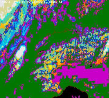
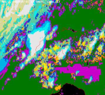
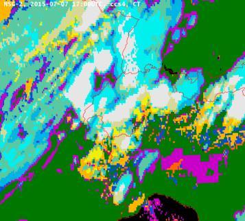

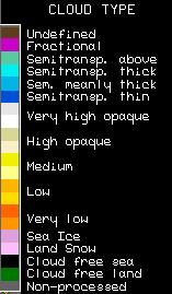
10 19UTC 17UTC 15UTC 13UTC Radar instantaneous precipitation rate Tests for Convective Initiation according to Mecikalsky TRT cell detection WV062-IR108 Number of CI tests Cloud Type


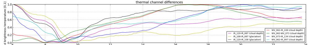
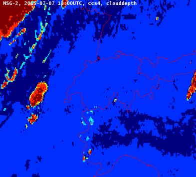
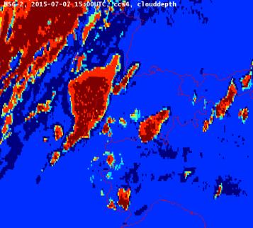
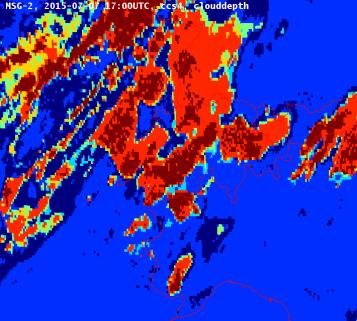
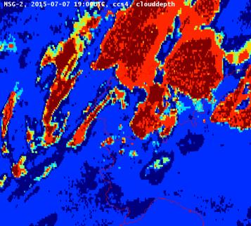
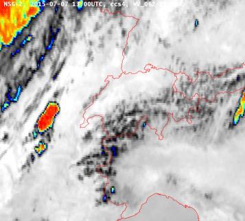
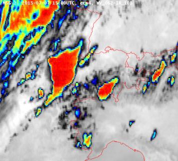
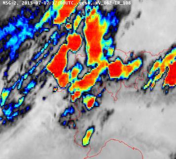
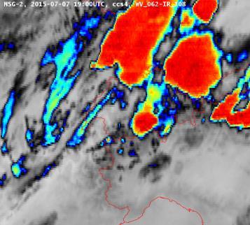
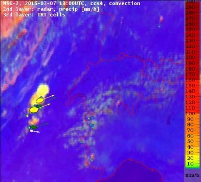
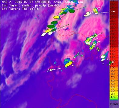
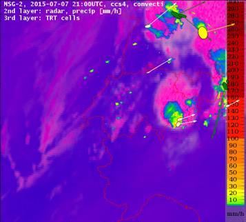
11 Radar Radar Combined satellite, radar, and lightning observations for 23 rd July UTC 09UTC 12UTC 15UTC 18UTC 21UTC 24UTC MSG SEVIRI MSG SEVIRI Lightning 06UTC 09UTC 12UTC 15UTC 18UTC 21UTC 24UTC 06UTC 09UTC 12UTC 15UTC 18UTC 21UTC 24UTC 11 06UTC 09UTC 12UTC 15UTC 18UTC 21UTC 24UTC
12 Summary Nowcasting Algorithms at MeteoSwiss Thunderstorm Radar Tracking COALITION First Generation COALITION Second Generation (in preparation) Goals of COALITION Input datasets: Radar, satellite, lightning, NWP Increase lead-time for warnings Forecast of intensification of thunderstorms COALITION SG Replacing pseudo-kinetic energy with regression and neural network technics Making use of long term statistics Multi-sensor analysis Satellite: Brightness temperatures, reflectivity, channel differences, temporal tendencies Radar: Maximum reflectivity, ECHOTOPS, MESH, POH Lightning: lightning density, cloud-ground, intra-cloud, current COSMO: CAPE, CIN, wind shear, tropopause height, freezing level
Hail nowcast exploiting radar and satellite observations
 Federal Department of Home Affairs FDHA Federal Office of Meteorology and Climatology MeteoSwiss Hail nowcast exploiting radar and satellite observations Ulrich Hamann, Elena Leonarduzzi, Kristopher Bedka,
Seamless nowcasting. Open issues
 Federal Department of Home Affairs FDHA Federal Office of Meteorology and Climatology MeteoSwiss Seamless nowcasting INCA Open issues Pierre Eckert Matteo Buzzi, Marco Sassi, Guido della Bruna, Marco Gaia
2.14 NOWCASTING THUNDERSTORMS IN COMPLEX CASES USING RADAR DATA
 2.14 NOWCASTING THUNDERSTORMS IN COMPLEX CASES USING RADAR DATA Alessandro M. Hering* 1, Stéphane Sénési 2, Paolo Ambrosetti 1, and Isabelle Bernard-Bouissières 2 1 MeteoSwiss, ML, Locarno-Monti, Switzerland
Satellite-based Convection Nowcasting and Aviation Turbulence Applications
 Satellite-based Convection Nowcasting and Aviation Turbulence Applications Kristopher Bedka Cooperative Institute for Meteorological Satellite Studies (CIMSS), University of Wisconsin-Madison In collaboration
Improving real time observation and nowcasting RDT. E de Coning, M Gijben, B Maseko and L van Hemert Nowcasting and Very Short Range Forecasting
 Improving real time observation and nowcasting RDT E de Coning, M Gijben, B Maseko and L van Hemert Nowcasting and Very Short Range Forecasting Introduction Satellite Application Facilities (SAFs) are
Nowcasting of Severe Weather from Satellite Images (for Southern
 Nowcasting of Severe Weather from Satellite Images (for Southern Europe) Petra Mikuš Jurković Forecasting/ nowcasting of convective storms NWP models cannot well predict the exact location and intesity
Hourly Precipitation Estimation through Rain-Gauge and Radar: CombiPrecip
 Federal Department of Home Affairs FDHA Federal Office of Meteorology and Climatology MeteoSwiss Documentation of MeteoSwiss Grid-Data Products Hourly Precipitation Estimation through Rain-Gauge and Radar:
"Experiences with use of EUMETSAT MPEF GII product for convection/storm nowcasting"
 "Experiences with use of EUMETSAT MPEF GII product for convection/storm nowcasting" Marianne König 1, Monika Pajek 2, Piotr Struzik 2 1) EUMETSAT 2) Institute of Meteorology and Water Management, Kraków,
Warning procedures for extreme events in the Emilia-Romagna Region
 Warning procedures for extreme events in the Emilia-Romagna Region Anna Fornasiero, Miria Celano, Roberta Amorati, Virginia Poli and Pier Paolo Alberoni Arpa Emilia-Romagna Hydro-Meteo-Climate Service,
CHARACTERISATION OF STORM SEVERITY BY USE OF SELECTED CONVECTIVE CELL PARAMETERS DERIVED FROM SATELLITE DATA
 CHARACTERISATION OF STORM SEVERITY BY USE OF SELECTED CONVECTIVE CELL PARAMETERS DERIVED FROM SATELLITE DATA Piotr Struzik Institute of Meteorology and Water Management, Satellite Remote Sensing Centre
A new era of hail monitoring, forecasting and climatology in Switzerland
 Federal Department of Home Affairs FDHA Federal Office of Meteorology and Climatology MeteoSwiss A new era of hail monitoring, forecasting and climatology in Switzerland Urs Germann, MeteoSwiss, Locarno-Monti
METEOSAT CONVECTIVE INITIATION PRODUCT WITH AND WITHOUT CLOUD TRACKING - EXPERIENCES
 METEOSAT CONVECTIVE INITIATION PRODUCT WITH AND WITHOUT CLOUD TRACKING - EXPERIENCES Mária Putsay 1, Zsófia Kocsis 1, Marianne König 2, Ildikó Szenyán 1, Márta Diószeghy 1, André Simon 1 and Márk Rajnai
ERAD Nowcasting thunderstorms in the Alpine region using a radar based adaptive thresholding scheme
 Proceedings of ERAD (2004): 206 211 c Copernicus GmbH 2004 ERAD 2004 Nowcasting thunderstorms in the Alpine region using a radar based adaptive thresholding scheme A. M. Hering 1, C. Morel 2, G. Galli
Hailstorms evidence from smart-phone users:
 Hailstorms evidence from smart-phone users: Crowd-sourced hail size data over Switzerland Noti Pascal A. Martynov, A. Hering, and O. Martius Bern 21.04.2017 Motivation & Objectives > Is crowd-sourcing
RDT-CW: TOWARD A MULTIDIMENSIONAL DESCRIPTION OF CONVECTION
 RDT-CW: TOWARD A MULTIDIMENSIONAL DESCRIPTION OF CONVECTION Jean-Marc Moisselin, Frederic Autonès Météo-France, DPREVI/PI, 42 avenue G. Coriolis 31057 Toulouse, France Abstract RDT-CW (Rapid Development
Nowcasting thunderstorms for aeronautical end-users
 Nowcasting thunderstorms for aeronautical end-users Jean-Marc Moisselin Météo-France, Nowcasting Department co-authors: Céline Jauffret (Météo-France) Overview Introduction SAT RADAR NWP image crédit:
Rapidly Developing Thunderstorm (RDT)
") Rapidly Developing Thunderstorm (RDT) Jean-Marc Moisselin, Frédéric Autones Météo-France Nowcasting Department 42, av. Gaspard Coriolis 31057 Toulouse France jean-marc.moisselin@meteo.fr EUMETRAIN Convection
Rapidly Developing Thunderstorm (RDT) Jean-Marc Moisselin, Frédéric Autones Météo-France Nowcasting Department 42, av. Gaspard Coriolis 31057 Toulouse France jean-marc.moisselin@meteo.fr EUMETRAIN Convection
WG4: interpretation and applications
 Federal Department of Home Affairs FDHA Federal Office of Meteorology and Climatology MeteoSwiss WG4: interpretation and applications Pierre Eckert MeteoSwiss, Geneva Topics FIELDEXTRA presentation by
ERAD THE SIXTH EUROPEAN CONFERENCE ON RADAR IN METEOROLOGY AND HYDROLOGY
 Radar and lightning data based classification scheme for the severity of convective cells Pekka Rossi 1, Kalle Halmevaara 2, Antti Mäkelä 1, Jarmo Koistinen 1, Vesa Hasu 2 1. Finnish Meteorological Institute,
MSG FOR NOWCASTING - EXPERIENCES OVER SOUTHERN AFRICA
 MSG FOR NOWCASTING - EXPERIENCES OVER SOUTHERN AFRICA Estelle de Coning and Marianne König South African Weather Service, Private Bag X097, Pretoria 0001, South Africa EUMETSAT, Am Kavalleriesand 31, D-64295
Judit Kerényi. OMSZ - Hungarian Meteorological Service, Budapest, Hungary. H-1525 Budapest, P.O.Box 38, Hungary.
 SATELLITE-DERIVED PRECIPITATION ESTIMATIONS DEVELOPED BY THE HYDROLOGY SAF PROJECT CASE STUDIES FOR THE INVESTIGATION OF THEIR ACCURACY AND FEATURES IN HUNGARY Judit Kerényi OMSZ - Hungarian Meteorological
SATELLITE MONITORING OF THE CONVECTIVE STORMS
 SATELLITE MONITORING OF THE CONVECTIVE STORMS FORECASTERS POINT OF VIEW Michaela Valachová, EUMETSAT Workshop at ECMWF User Meeting Reading, 13 June 2017 Central Forecasting Office, Prague michaela.valachova@chmi.cz
For the operational forecaster one important precondition for the diagnosis and prediction of
 Initiation of Deep Moist Convection at WV-Boundaries Vienna, Austria For the operational forecaster one important precondition for the diagnosis and prediction of convective activity is the availability
Satellite-based thunderstorm tracking, monitoring and nowcasting over South Africa
 Satellite-based thunderstorm tracking, monitoring and nowcasting over South Africa Caroline Forster 1, Estelle de Coning 2, Sebastian Diebel 1, Tobias Zinner 3 EUMETSAT Meteorological Satellite Conference
REPORT ON THE ACTIVITIES OF THE EUMETSAT-ESSL CONVECTION WORKING GROUP
 REPORT ON THE ACTIVITIES OF THE EUMETSAT-ESSL CONVECTION WORKING GROUP Marianne König EUMETSAT, Eumetsat Allee 1, 64295 Darmstadt, Germany Abstract The focus of the Convection Working Group is to have
Validation Report for Precipitation products from Cloud Physical Properties (PPh-PGE14: PCPh v1.0 & CRPh v1.0)
") Page: 1/26 Validation Report for Precipitation SAF/NWC/CDOP2/INM/SCI/VR/15, Issue 1, Rev. 0 15 July 2013 Applicable to SAFNWC/MSG version 2013 Prepared by AEMET Page: 2/26 REPORT SIGNATURE TABLE Function
Page: 1/26 Validation Report for Precipitation SAF/NWC/CDOP2/INM/SCI/VR/15, Issue 1, Rev. 0 15 July 2013 Applicable to SAFNWC/MSG version 2013 Prepared by AEMET Page: 2/26 REPORT SIGNATURE TABLE Function
NWP in aviation: CAT diagnostics
 Federal Department of Home Affairs FDHA Federal Office of Meteorology and Climatology MeteoSwiss NWP in aviation: CAT diagnostics Pierre Eckert MeteoSwiss, Geneva Topics Motivation and backgroud Use of
Utilising Radar and Satellite Based Nowcasting Tools for Aviation Purposes in South Africa. Erik Becker
 Utilising Radar and Satellite Based Nowcasting Tools for Aviation Purposes in South Africa Erik Becker Morné Gijben, Mary-Jane Bopape, Stephanie Landman South African Weather Service: Nowcasting and Very
Update on CoSPA Storm Forecasts
 Update on CoSPA Storm Forecasts Haig August 2, 2011 This work was sponsored by the Federal Aviation Administration under Air Force Contract No. FA8721-05-C-0002. Opinions, interpretations, conclusions,
USE OF SATELLITE INFORMATION IN THE HUNGARIAN NOWCASTING SYSTEM
 USE OF SATELLITE INFORMATION IN THE HUNGARIAN NOWCASTING SYSTEM Mária Putsay, Zsófia Kocsis and Ildikó Szenyán Hungarian Meteorological Service, Kitaibel Pál u. 1, H-1024, Budapest, Hungary Abstract The
A satellite-based long-term Land Surface Temperature Climate Data Record
 Federal Department of Home Affairs FDHA Federal Office of Meteorology and Climatology MeteoSwiss A satellite-based long-term Land Surface Temperature Climate Data Record, Virgílio A. Bento, Frank M. Göttsche,
U. S. Contributions to COPS: Satellite-estimated Convective Initiation
 U. S. Contributions to COPS: Satellite-estimated Convective Initiation John R. Mecikalski 1, Kristopher M. Bedka 2 Simon J. Paech 1, Todd A. Berendes 1, Wayne M. Mackenzie 1 1 Atmospheric Science Department
H-SAF VSA Programme HSAF_ CDOP2_VS14_03
 H-SAF VSA Programme HSAF_ CDOP2_VS14_03 Improvements on the PR-OBS-6 H-SAF precipitation product using multispectral markers from geostationary satellite data Final report Index 1. SCOPE OF THE DOCUMENT...
H-SAF future developments on Convective Precipitation Retrieval
 H-SAF future developments on Convective Precipitation Retrieval Francesco Zauli 1, Daniele Biron 1, Davide Melfi 1, Antonio Vocino 1, Massimiliano Sist 2, Michele De Rosa 2, Matteo Picchiani 2, De Leonibus
EUMETSAT Satellite Programmes Use of McIDAS at EUMETSAT
 EUMETSAT Satellite Programmes Use of McIDAS at EUMETSAT Marianne König Peter Miu McIDAS Users' Group Meeting, 07-10 May 2012 Slide 1 EUMETSAT Headquarters Darmstadt McIDAS Users' Group Meeting, 07-10 May
Observations needed for verification of additional forecast products
 Observations needed for verification of additional forecast products Clive Wilson ( & Marion Mittermaier) 12th Workshop on Meteorological Operational Systems, ECMWF, 2-6 November 2009 Additional forecast
1.29 LIFE CYCLE OF CONVECTIVE CELLS WITH RAPID SCAN SATELLITE AND RADAR DATA IN THE EASTERN ALPINE REGION
 1.29 LIFE CYCLE OF CONVECTIVE CELLS WITH RAPID SCAN SATELLITE AND RADAR DATA IN THE EASTERN ALPINE REGION Friedrich Wölfelmaier 1, Veronika Zwatz-Meise 2 1 ZAMG, Regional center Styria, Graz, Austria,
PRECONVECTIVE SOUNDING ANALYSIS USING IASI AND MSG- SEVIRI
 PRECONVECTIVE SOUNDING ANALYSIS USING IASI AND MSG- SEVIRI Marianne König, Dieter Klaes EUMETSAT, Eumetsat-Allee 1, 64295 Darmstadt, Germany Abstract EUMETSAT operationally generates the Global Instability
Detection of convective overshooting tops using Himawari-8 AHI, CloudSat CPR, and CALIPSO data
 Detection of convective overshooting tops using Himawari-8 AHI, CloudSat CPR, and CALIPSO data Miae Kim¹, Jungho Im¹, Seonyoung Park¹ ¹Ulsan National Institute of Science and Technology (UNIST), South
QUALITY OF MPEF DIVERGENCE PRODUCT AS A TOOL FOR VERY SHORT RANGE FORECASTING OF CONVECTION
 QUALITY OF MPEF DIVERGENCE PRODUCT AS A TOOL FOR VERY SHORT RANGE FORECASTING OF CONVECTION C.G. Georgiev 1, P. Santurette 2 1 National Institute of Meteorology and Hydrology, Bulgarian Academy of Sciences
MSGVIEW: AN OPERATIONAL AND TRAINING TOOL TO PROCESS, ANALYZE AND VISUALIZATION OF MSG SEVIRI DATA
 MSGVIEW: AN OPERATIONAL AND TRAINING TOOL TO PROCESS, ANALYZE AND VISUALIZATION OF MSG SEVIRI DATA Aydın Gürol Ertürk Turkish State Meteorological Service, Remote Sensing Division, CC 401, Kalaba Ankara,
DATA FUSION NOWCASTING AND NWP
 DATA FUSION NOWCASTING AND NWP Brovelli Pascal 1, Ludovic Auger 2, Olivier Dupont 1, Jean-Marc Moisselin 1, Isabelle Bernard-Bouissières 1, Philippe Cau 1, Adrien Anquez 1 1 Météo-France Forecasting Department
Page 1/8 Long duration validation of PGE11. SAF - Nowcasting Product Assessment Review Worshop (Madrid ctober 2005
 Page 1/8 Plan Research activity (visiting scientist: Oleksiy Kryvobok) Use of other PGEs and HRVis for RDT improvement Tuning PGE11 satellite-based discrimination using SEVIRI data Long duration validation
NOWCASTING PRODUCTS BASED ON MTSAT-1R RAPID SCAN OBSERVATION. In response to CGMS Action 38.33
 CGMS-39, JMA-WP-08 Prepared by JMA Agenda Item: G.II/8 Discussed in WG II NOWCASTING PRODUCTS BASED ON MTSAT-1R RAPID SCAN OBSERVATION In response to CGMS Action 38.33 This document reports on JMA s MTSAT-1R
A statistical approach for rainfall confidence estimation using MSG-SEVIRI observations
 A statistical approach for rainfall confidence estimation using MSG-SEVIRI observations Elisabetta Ricciardelli*, Filomena Romano*, Nico Cimini*, Frank Silvio Marzano, Vincenzo Cuomo* *Institute of Methodologies
The Nowcasting Demonstration Project for London 2012
 The Nowcasting Demonstration Project for London 2012 Susan Ballard, Zhihong Li, David Simonin, Jean-Francois Caron, Brian Golding, Met Office, UK Introduction The success of convective-scale NWP is largely
Performance of TANC (Taiwan Auto- Nowcaster) for 2014 Warm-Season Afternoon Thunderstorm
 for 2014 Warm-Season Afternoon Thunderstorm") Performance of TANC (Taiwan Auto- Nowcaster) for 2014 Warm-Season Afternoon Thunderstorm Wei-Peng Huang, Hui-Ling Chang, Yu-Shuang Tang, Chia-Jung Wu, Chia-Rong Chen Meteorological Satellite Center, Central
Performance of TANC (Taiwan Auto- Nowcaster) for 2014 Warm-Season Afternoon Thunderstorm Wei-Peng Huang, Hui-Ling Chang, Yu-Shuang Tang, Chia-Jung Wu, Chia-Rong Chen Meteorological Satellite Center, Central
DIAGNOSING OBSERVATION ERROR STATISTICS FOR NUMERICAL WEATHER PREDICTION
 DIAGNOSING OBSERVATION ERROR STATISTICS FOR NUMERICAL WEATHER PREDICTION J. Waller, S. Dance, N. Nichols (University of Reading) D. Simonin, S. Ballard, G. Kelly (Met Office) 1 AIMS 2 OBSERVATION ERRORS
Near Real-time Cloud Classification, Mesoscale Winds, and Convective Initiation Fields from MSG Data
 Near Real-time Cloud Classification, Mesoscale Winds, and Convective Initiation Fields from MSG Data Wayne Feltz *, J. Mecikalski, and K. Bedka * Cooperative Institute of Meteorological Satellite Studies
T-re Plots Generated from MSG Data in Severe Storms Forecasting Testing in Central Europe
 WDS'11 Proceedings of Contributed Papers, Part III, 88 92, 2011. ISBN 978-80-7378-186-6 MATFYZPRESS T-re Plots Generated from MSG Data in Severe Storms Forecasting Testing in Central Europe M. Pokorný
RGB Experts and Developers Workshop 2017 Tokyo, Japan
 "Application of the Sandwich Product and variations to this as used by Australian Forecasters and as presented during training at the Australian VLab Centre of Excellence". RGB Experts and Developers Workshop
Combining Meteosat data and weather radar products to improve the meteorological surveillance and nowcasting
 Combining Meteosat data and weather radar products to improve the meteorological surveillance and nowcasting R. Hernandez (1)(2), S. Gaztelumendi (1)(2), K. Otxoa de Alda (1)(2), I. R. Gelpi (1)(2), J.
COSMO model simulations for COPS, 15 July 2007 (IOP 8b)
") COSMO model simulations for COPS, 15 July 2007 (IOP 8b) Jörg Trentmann, Björn Brötz, Heini Wernli Institute for Atmospheric Physics Johannes Gutenberg University Mainz OUTLINE The Convective and Orographically-
COSMO model simulations for COPS, 15 July 2007 (IOP 8b) Jörg Trentmann, Björn Brötz, Heini Wernli Institute for Atmospheric Physics Johannes Gutenberg University Mainz OUTLINE The Convective and Orographically-
Radar precipitation measurement in the Alps big improvements triggered by MAP
 Radar precipitation measurement in the Alps big improvements triggered by MAP Urs Germann, Gianmario Galli, Marco Boscacci MeteoSwiss, Locarno-Monti MeteoSwiss radar Monte Lema, 1625m Can we measure precipitation
Detailed flow, hydrometeor and lightning characteristics of an isolated, hail producing thunderstorm during COPS
 Detailed flow, hydrometeor and lightning characteristics of an isolated, hail producing thunderstorm during COPS, Martin Hagen, Hartmut Höller, Hans Volkert Institut für Physik der Atmosphäre, DLR Oberpfaffenhofen
OBJECTIVE USE OF HIGH RESOLUTION WINDS PRODUCT FROM HRV MSG CHANNEL FOR NOWCASTING PURPOSES
 OBJECTIVE USE OF HIGH RESOLUTION WINDS PRODUCT FROM HRV MSG CHANNEL FOR NOWCASTING PURPOSES José Miguel Fernández Serdán, Javier García Pereda Servicio de Técnicas de Análisis y Predicción, Servicio de
<Operational nowcasting systems in the framework of the 4-D MeteoCube>
 Background Nowcasting is applicable
Application of automated CB/TCU detection based on radar and satellite data
 Application of automated CB/TCU detection based on radar and satellite data Paul de Valk, and Rudolf van Westhrenen Royal Netherlands Meteorological Institute, Ministry of Infrastruture and Environment
Introduction to the NWC SAF
 Introduction to the NWC SAF NWC SAF Event Week EUMeTrain course 18-22 November, online P. Fernández 1 Where are you listening from? Contents SAF Network scope NWC SAF Overview Products Next versions 2014
STATISTICAL ANALYSIS ON SEVERE CONVECTIVE WEATHER COMBINING SATELLITE, CONVENTIONAL OBSERVATION AND NCEP DATA
 12.12 STATISTICAL ANALYSIS ON SEVERE CONVECTIVE WEATHER COMBINING SATELLITE, CONVENTIONAL OBSERVATION AND NCEP DATA Zhu Yaping, Cheng Zhoujie, Liu Jianwen, Li Yaodong Institute of Aviation Meteorology
COMBINED USE OF AN INSTABILITY INDEX AND SEVIRI WATER VAPOR IMAGERY TO DETECT UNSTABLE AIR MASSES
 COMBINED USE OF AN INSTABILITY INDEX AND SEVIRI WATER VAPOR IMAGERY TO DETECT UNSTABLE AIR MASSES Stavros Kolios 1,2, Chrysostomos Stylios 1 1 Laboratory of Knowledge and Intelligent Computing (KIC-LAB),
INTERPRETATION OF MSG IMAGES, PRODUCTS AND SAFNWC OUTPUTS FOR DUTY FORECASTERS
 INTERPRETATION OF MSG IMAGES, PRODUCTS AND SAFNWC OUTPUTS FOR DUTY FORECASTERS M. Putsay, M. Rajnai, M. Diószeghy, J. Kerényi, I.G. Szenyán and S. Kertész Hungarian Meteorological Service, H-1525 Budapest,
Research on Lightning Nowcasting and Warning System and Its Application
 Research on Lightning Nowcasting and Warning System and Its Application Wen Yao Chinese Academy of Meteorological Sciences Beijing, China yaowen@camscma.cn 2016.07 1 CONTENTS 1 2 3 4 Lightning Hazards
Sandrine Cazabat, Michel Bouzom, Jérôme Reynaud
 7.08 NOWCASTING THUNDERSTORMS WITH SIGOONS A SIGNIFICANT WEATHER OBJECT ORIENTED NOWCASTING SYSTEM Pascal Brovelli *, Stéphane Sénési, Etienne Arbogast, Philippe Cau, Sandrine Cazabat, Michel Bouzom, Jérôme
P5.7 THE ADVANCED SATELLITE AVIATION WEATHER PRODUCTS (ASAP) INITIATIVE: PHASE I EFFORTS AT THE UNIVERSITY OF ALABAMA IN HUNTSVILLE
 INITIATIVE: PHASE I EFFORTS AT THE UNIVERSITY OF ALABAMA IN HUNTSVILLE") P5.7 THE ADVANCED SATELLITE AVIATION WEATHER PRODUCTS (ASAP) INITIATIVE: PHASE I EFFORTS AT THE UNIVERSITY OF ALABAMA IN HUNTSVILLE John R. Mecikalski #1, Todd A. Berendes #, U. S. Nair #, Wayne F. Feltz*,
P5.7 THE ADVANCED SATELLITE AVIATION WEATHER PRODUCTS (ASAP) INITIATIVE: PHASE I EFFORTS AT THE UNIVERSITY OF ALABAMA IN HUNTSVILLE John R. Mecikalski #1, Todd A. Berendes #, U. S. Nair #, Wayne F. Feltz*,
Cb-LIKE: thunderstorm forecasts up to 6 hrs with fuzzy logic
 Cb-LIKE: thunderstorm forecasts up to 6 hrs with fuzzy logic Martin Köhler DLR Oberpfaffenhofen 15th EMS/12th ECAM 07 11 September, Sofia, Bulgaria Long-term forecasts of thunderstorms why? -> Thunderstorms
B.W.Golding * Met Office, Exeter, UK
 7.35 A NEW APPROACH TO NOWCASTING AT THE MET OFFICE B.W.Golding * Met Office, Exeter, UK 1. BACKGROUND * The Nimrod system was introduced into operational use in the Met Office in 1996 (Golding, 1998).
CASE STUDY OF THE 20 MAY 2008 TORNADIC STORM IN HUNGARY
 CASE STUDY OF THE 20 MAY 2008 TORNADIC STORM IN HUNGARY Mária Putsay 1, Jochen Kerkmann 2 and Ildikó Szenyán 1 1 Hungarian Meteorological Service, H-1525 Budapest, P. O. Box 38, Hungary 2 EUMETSAT, am
Observation minus Background Statistics for Humidity and Temperature from Raman lidar, microwave radiometer and COSMO-2
 Federal Department of Home Affairs FDHA Federal Office of Meteorology and Climatology MeteoSwiss Observation minus Background Statistics for Humidity and Temperature from Raman lidar, microwave radiometer
An Algorithm to Nowcast Lightning Initiation and Cessation in Real-time
 An Algorithm to Nowcast Initiation and Cessation in Real-time An Data Mining Model Valliappa 1,2 Travis Smith 1,2 1 Cooperative Institute of Mesoscale Meteorological Studies University of Oklahoma 2 Radar
Verification of different wind gust parametrizations Overview of verification results at MeteoSwiss in the year 2012
 Federal Department of Home Affairs FDHA Federal Office of Meteorology and Climatology MeteoSwiss Verification of different wind gust parametrizations Overview of verification results at MeteoSwiss in the
Schweizerische Eidgenossenschaft Confédération suisse Confederazione Svizzera Confederazium svizra
 Schweizerische Eidgenossenschaft Confédération suisse Confederazione Svizzera Confederazium svizra Federal Department of Home Affairs FDHA Federal Office of Meteorology and Climatology MeteoSwiss Swiss
The D PHASE Operations Period (DOP)
") Federal Department of Home Affairs FDHA Federal Office of Meteorology and Climatology MeteoSwiss The D PHASE Operations Period (DOP) Mathias W Rotach, Marco Arpagaus MeteoSwiss, Zürich, Switzerland Manfred
Federal Department of Home Affairs FDHA Federal Office of Meteorology and Climatology MeteoSwiss The D PHASE Operations Period (DOP) Mathias W Rotach, Marco Arpagaus MeteoSwiss, Zürich, Switzerland Manfred
Validation of Direct Normal Irradiance from Meteosat Second Generation. DNICast
 Validation of Direct Normal Irradiance from Meteosat Second Generation DNICast A. Meyer 1), L. Vuilleumier 1), R. Stöckli 1), S. Wilbert 2), and L. F. Zarzalejo 3) 1) Federal Office of Meteorology and
MeteoSwiss Spatial Climate Analyses: Documentation of Datasets for Users
 Federal Department of Home Affairs FDHA Federal Office of Meteorology and Climatology MeteoSwiss MeteoSwiss Spatial Climate Analyses: Documentation of Datasets for Users Figure 1: Distribution of the 48-hour
Simulation of heavy precipitation events with the COSMO model
 LM User Seminar, 6 March 2007, Langen Federal Department of Home Affairs FDHA Federal Office of Meteorology and Climatology MeteoSwiss Simulation of heavy precipitation events with the COSMO model Silke
Guidance on Aeronautical Meteorological Observer Competency Standards
 Guidance on Aeronautical Meteorological Observer Competency Standards The following guidance is supplementary to the AMP competency Standards endorsed by Cg-16 in Geneva in May 2011. Format of the Descriptions
EUMETSAT products and services for monitoring storms - New missions, more data and more meteorological products
 EUMETSAT products and services for monitoring storms - New missions, more data and more meteorological products Jochen Grandell 1 EUM/RSP/VWG/17/921460 Outline Overview of EUMETSAT missions Current...and
Description of the case study
 Description of the case study During the night and early morning of the 14 th of July 011 the significant cloud layer expanding in the West of the country and slowly moving East produced precipitation
WMO Aeronautical Meteorology Scientific Conference 2017
 Session 1 Science underpinning meteorological observations, forecasts, advisories and warnings 1.6 Observation, nowcast and forecast of future needs 1.6.1 Advances in observing methods and use of observations
Global Instability Index: Product Guide
 Doc.No. Issue : : EUM/TSS/MAN/15/802106 v1c e-signed EUMETSAT Eumetsat-Allee 1, D-64295 Darmstadt, Germany Tel: +49 6151 807-7 Fax: +49 6151 807 555 Date : 2 September 2015 http://www.eumetsat.int WBS/DBS
Cb-TRAM: Tracking and monitoring severe convection from onset over rapid development to mature phase using multi-channel Meteosat-8 SEVIRI data
 Meteorol Atmos Phys (2008) DOI 10.1007/s00703-008-0290-y Printed in The Netherlands Institut f ur Physik der Atmosph are, Deutsches Zentrum f ur Luft- und Raumfahrt, DLR Oberpfaffenhofen, Germany Cb-TRAM:
Overview on project activities with regard to thunderstorms
 Overview on project activities with regard to thunderstorms Arnold Tafferner Co-workers: C. Forster, H. Mannstein, T. Zinner, M. Hagen, T. Gerz, DLR Institut für Physik der Atmosphäre (IPA) Wetter&Fliegen
THE NWC SAF PRODUCTS
 THE NWC SAF PRODUCTS EUMETSAT AUTH TRAINING WORKSHOP ON THE USE OF SATELLITE INFORMATION IN NOWCASTING 11 15 September 2017, Thessaloniki, Greece J. M. Gallardo 1 CONTENTS Introduction NWC SAF Overview
THE EUMETSAT MULTI-SENSOR PRECIPITATION ESTIMATE (MPE)
") THE EUMETSAT MULTI-SENSOR PRECIPITATION ESTIMATE (MPE) Thomas Heinemann, Alessio Lattanzio and Fausto Roveda EUMETSAT Am Kavalleriesand 31, 64295 Darmstadt, Germany ABSTRACT The combination of measurements
THE EUMETSAT MULTI-SENSOR PRECIPITATION ESTIMATE (MPE) Thomas Heinemann, Alessio Lattanzio and Fausto Roveda EUMETSAT Am Kavalleriesand 31, 64295 Darmstadt, Germany ABSTRACT The combination of measurements
EARLY ONLINE RELEASE
 EARLY ONLINE RELEASE This is a PDF of a manuscript that has been peer-reviewed and accepted for publication. As the article has not yet been formatted, copy edited or proofread, the final published version
QualiMET 2.0. The new Quality Control System of Deutscher Wetterdienst
 QualiMET 2.0 The new Quality Control System of Deutscher Wetterdienst Reinhard Spengler Deutscher Wetterdienst Department Observing Networks and Data Quality Assurance of Meteorological Data Michendorfer
COLD-RING AND COLD-U/V SHAPED STORMS
 MARTIN SETVÁK setvak@chmi.cz Czech Hydrometeorological Institute, Prague COLD-RING AND COLD-U/V SHAPED STORMS Version : 18 May 2009 What are the cold-ring and cold-u/v shaped storms? Appearance and terminology
Figure 5: Comparison between SAFIR warning and radar-based hail detection for the hail event of June 8, 2003.
 SAFIR WARNING : Expected risk Radar-based Probability of Hail 0915 0930 0945 1000 Figure 5: Comparison between SAFIR warning and radar-based hail detection for the hail event of June 8, 2003. Lightning
STEPS-BE: an ensemble radar rainfall nowcasting system for urban hydrology in Belgium
 STEPS-BE: an ensemble radar rainfall nowcasting system for urban hydrology in Belgium Loris Foresti 1,2, Maarten Reyniers 2, Lesley De Cruz 2, Alan Seed 3 and Laurent Delobbe 2 with contributions from
MAIN ATTRIBUTES OF THE PRECIPITATION PRODUCTS DEVELOPED BY THE HYDROLOGY SAF PROJECT RESULTS OF THE VALIDATION IN HUNGARY
 MAIN ATTRIBUTES OF THE PRECIPITATION PRODUCTS DEVELOPED BY THE HYDROLOGY SAF PROJECT RESULTS OF THE VALIDATION IN HUNGARY Eszter Lábó OMSZ-Hungarian Meteorological Service, Budapest, Hungary labo.e@met.hu
P5.11 TACKLING THE CHALLENGE OF NOWCASTING ELEVATED CONVECTION
 P5.11 TACKLING THE CHALLENGE OF NOWCASTING ELEVATED CONVECTION Huaqing Cai*, Rita Roberts, Dan Megenhardt, Eric Nelson and Matthias Steiner National Center for Atmospheric Research, Boulder, CO, 80307,
ERAD Quantitative precipitation estimation in the Alps: where do we stand? Proceedings of ERAD (2004): 2 6 c Copernicus GmbH 2004
: 2 6 c Copernicus GmbH 2004") Proceedings of ERAD (2004): 2 6 c Copernicus GmbH 2004 ERAD 2004 Quantitative precipitation estimation in the Alps: where do we stand? U. Germann 1, G. Galli 1, M. Boscacci 1, M. Bolliger 1, and M. Gabella
Proceedings of ERAD (2004): 2 6 c Copernicus GmbH 2004 ERAD 2004 Quantitative precipitation estimation in the Alps: where do we stand? U. Germann 1, G. Galli 1, M. Boscacci 1, M. Bolliger 1, and M. Gabella
SATELLITE SIGNATURES ASSOCIATED WITH SIGNIFICANT CONVECTIVELY-INDUCED TURBULENCE EVENTS
 SATELLITE SIGNATURES ASSOCIATED WITH SIGNIFICANT CONVECTIVELY-INDUCED TURBULENCE EVENTS Kristopher Bedka 1, Wayne Feltz 1, John Mecikalski 2, Robert Sharman 3, Annelise Lenz 1, and Jordan Gerth 1 1 Cooperative
Air Mass Thunderstorms. Air Mass Thunderstorms. Air Mass Thunderstorms. Lecture 26 Air Mass Thunderstorms and Lightning
 Lecture 26 and Lightning Life Cycle Environment Climatology Lightning 1 2 Short-lived, isolated thunderstorms that are not severe are often called air-mass thunderstorms. There are three stages describing
A HIGH RESOLUTION EUROPEAN CLOUD CLIMATOLOGY FROM 15 YEARS OF NOAA/AVHRR DATA
 A HIGH RESOLUTION EUROPEAN CLOUD CLIMATOLOGY FROM 15 YEARS OF NOAA/AVHRR DATA R. Meerkötter 1, G. Gesell 2, V. Grewe 1, C. König 1, S. Lohmann 1, H. Mannstein 1 Deutsches Zentrum für Luft- und Raumfahrt
Combined and parallel use of MSG composite images and SAFNWC/MSG products at the Hungarian Meteorological Service
 Combined and parallel use of MSG composite images and SAFNWC/MSG products at the Hungarian Meteorological Service Mária Putsay, Kornél Kolláth and Ildikó Szenyán Hungarian Meteorological Service H-1525
Figure 1: Tephigram for radiosonde launched from Bath at 1100 UTC on 15 June 2005 (IOP 1). The CAPE and CIN are shaded dark and light gray,
. The CAPE and CIN are shaded dark and light gray,") Figure 1: Tephigram for radiosonde launched from Bath at 1100 UTC on 1 June 200 (IOP 1). The CAPE and CIN are shaded dark and light gray, respectively; the thin solid line partially bounding these areas
Figure 1: Tephigram for radiosonde launched from Bath at 1100 UTC on 1 June 200 (IOP 1). The CAPE and CIN are shaded dark and light gray, respectively; the thin solid line partially bounding these areas
Plan for operational nowcasting system implementation in Pulkovo airport (St. Petersburg, Russia)
") Plan for operational nowcasting system implementation in Pulkovo airport (St. Petersburg, Russia) Pulkovo airport (St. Petersburg, Russia) is one of the biggest airports in the Russian Federation (150
Plan for operational nowcasting system implementation in Pulkovo airport (St. Petersburg, Russia) Pulkovo airport (St. Petersburg, Russia) is one of the biggest airports in the Russian Federation (150
Simulated MSG SEVIRI Imagery from HARMONIE-AROME
 Simulated MSG SEVIRI Imagery from HARMONIE-AROME Angeles Hernandez, AEMET Joint 28th ALADIN Workshop & HIRLAM All-Staff Meeting 2018 - Toulouse, 16-20 Apr 2018 Outline 1. Simulated Satellite Images (SSI)