SATELLITE MONITORING OF THE CONVECTIVE STORMS
|
|
|
- Heather Cole
- 6 years ago
- Views:
Transcription
1 SATELLITE MONITORING OF THE CONVECTIVE STORMS FORECASTERS POINT OF VIEW Michaela Valachová, EUMETSAT Workshop at ECMWF User Meeting Reading, 13 June 2017 Central Forecasting Office, Prague

2 OBJECTIVES OF PRESENTATION storm forecasting o from long-range forecast to nowcasting storm monitoring o satellites and geometry o storm appearance data visualization o IR-BT, RGB, sandwich

3 FORECASTER S POINT OF VIEW convective storms are challenging o where and when will storm evolve? o how dangerous will it be? o how long will it last? satellite data are crucial o information every 5 min o helpful products o years of experience

4 STORM FORECASTING long-range forecast o up to 10 days o ensembles, probability short-range forecast o today and tomorrow o synoptic analysis nowcasting o now or several hours o observations, monitoring
5 STORM MONITORING operational weather satellites (overview) basic appearance on satellite images visualization techniques o cloud-top brightness temperature» cold-u and cold ring features, overshooting tops o cloud-top reflectivity in µm» small ice particles, above-anvil (ice) plumes o RGB and Sandwich products


 from the satellite data")
6 Storms from above Satellites with passive radiometers can monitor the cloud tops only, they do not see inside the storms, or even under them! Thus, these satellites can t provide us with a direct information about the weather conditions under the storms, such information has to be inferred (derived) from the satellite data indirectly, utilizing conceptual models of convective storms.

 or")
7 Storms from above which operational weather satellites to use: geostationary (GEO) or low-earth orbit (LEO) ones? 2014

8 Aqua/MODIS :25 UTC; hail occurrence at 12:26 UTC
 IR10.")
")
 HRV 2016-06-20 12:46")
9 :45 UTC MSG/SEVIRI (3 km) IR :46 UTC Suomi-NPP/VIIRS (375 m) I5 band :45 UTC MSG/SEVIRI (1 km) HRV :46 UTC Suomi-NPP/VIIRS (375 m) I1 band
10 BASIC APPEARANCE OF STORMS size and shape of convective storms affected by: internal storm dynamics storm updrafts (strength, duration), storm splitting (supercells) interaction with other storm cells merging of anvils interaction with environment wind shear, storm relative winds, moisture viewing geometry scan conditions: nadir vs low angle parallax shift effect, re-mapping» problems with accurate geo-referencing of higher clouds and some of the derived products


11 Suomi-NPP/VIIRS band 1 11:05 UTC ~ 375 m MSG/SEVIRI HRV 11:05 UTC ~ 1 km
 strongly depends on their actual height above the ground level and on the scanning")
12 Parallax shift in satellite imagery Projection of various cloud-top features to surface (georeferencing, navigation, remapping) strongly depends on their actual height above the ground level and on the scanning geometry.


13 SPATIAL RESOLUTION the position of the satellite: Meteosat W Meteosat-10 0 Meteosat E Meteosat E The closer to the sub-satellite point, the better is the image quality (lesser distortion, higher image resolution, smaller parallax shift)

14 Above-anvil (ice) plumes Nebraska, 22/23May 1996, 0045 UTC GOES 8 (East)

15 Above-anvil (ice) plumes Nebraska, 22/23May 1996, 0045 UTC GOES 9 (West)


16 Impact of the wind shear weak shear :00, Meteosat-8, north Italy


17 Impact of the wind shear strong shear :37, Meteosat-8, south Germany


18 VISUALIZATION TECHNIQUES detection of various cloud-top features: o overshooting tops, plumes, gravity waves o cold-u or cold-ring shapes, small ice particles IR 10.8 BT color-enhancement Storm RGB product Sandwich product 11 June :20 UTC, The Baltics, Meteosat-9 (RSS data)

19 Color enhancement of the IR brightness temperature imagery Color enhancement of the IR Brightness Temperature (BT) imagery replacement of a part of the grey scale, representing a certain temperature range, by dedicated colors. The color scale can either be continuous - using a maximum of available colors, or a step-scale, using only a limited number of colors (each color representing a smaller BT interval).

20 Cold-U/V (enhanced-v) shaped storms example and terminology: HRV Meteosat-9 (MSG2) 15:00 UTC IR 10.8 BT ENH DISTANT WARM AREA (DWA) CLOSE-IN WARM AREA (CWA) COLD-U 26 May 2007, Germany
 COLD RING 25 June 2006, Czech Republic and")
21 Cold-ring-shaped storms example and terminology: HRV Meteosat-8 (MSG1) 13:45 UTC IR 10.8 BT ENH CENTRAL WARM SPOT (CWS) COLD RING 25 June 2006, Czech Republic and Austria
 µm cloud-top")


22 The 3.7 (3.9) µm cloud-top reflectivity of convective storms 09 July 1987, 1354 UTC, NOAA 9 AVHRR CH AVHRR CH 4 ENH AVHRR CH 3 ENH


23 RGB PRODUCTS NOAA/AVHRR :40 UTC a channel 1 (0,58-0,68 µm) b channel 2 (0,73-1,00 µm) c channel 4 (10,3-11,3 µm)
 µm cloud-top reflectivity of convective storms Example of the storm RGB (or")
24 The 3.7 (3.9) µm cloud-top reflectivity of convective storms Example of the storm RGB (or convection RGB ) product: 11 June :30 UTC Meteosat-10 (MSG-3)


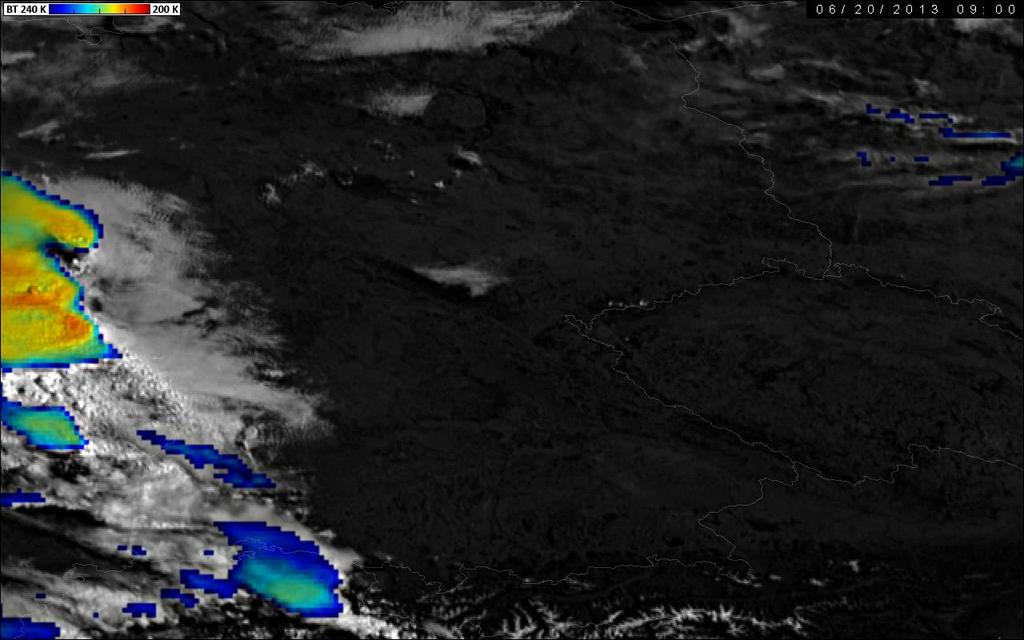
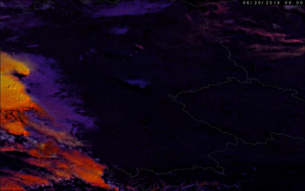
25 The sandwich product of IR-window and visible bands AVHRR band 2 AVHRR band 4 BT ( K) :35 UTC NOAA 15 (South Dakota, Minnesota, Nebraska, Iowa, U.S.A.)
26 Visible color enh. IR-BT sandwich product principle of the method Upper layer: IR-window BT image Bottom layer ( background ): VIS image Multi-layer image (in this case 2 layers) e.g. PSD format (Photoshop) Blending options applied to the upper layer!!!
")
27 The sandwich product of IR-window and visible bands :35 UTC NOAA 15 (South Dakota, Minnesota, Nebraska, Iowa, U.S.A.)


28 Visible color enhanced IR-BT sandwich product HRV IR10.8-BT 12 July :40 UTC MSG-1, Germany
29 Visible color enhanced IR-BT sandwich product HRV sandwich HRV & IR10.8-BT 12 July :40 UTC MSG-1, Germany
30 Visible color enhanced IR-BT sandwich product sandwich HRV & storm RGB sandwich HRV & IR10.8-BT 12 July :40 UTC MSG-1, Germany
31 SEVERE STORM CHARACTERISTICS lifecycle: o rapid development, long lasting o outflow, splitting, right-mover cloud-top features: o overshooting tops (OT) ~ storm activity, intensity of updrafts o cold-u or cold-ring shape in IR-BT ~ related with OT, rapid cooling o small ice particles, plume o gravity waves, ship waves ~ related with OT shape of the anvil: o weak/strong wind shear or storm-relative winds
32
33
34 APPLICATIONS storms observed by satellites FIRST cloud-top features as an indicator of severity satellite data as part of nowcasting tools: o ProbSevere (USA, CIMSS SSEC) o COALITION (Switzerland, MeteoSwiss) Nowcasting SAF (Pilar Ripodas)
")
35 THANK YOU :43 UTC VIIRS Day-Night Band (DNB) Italy, Croatia, Slovenia City lights Land and storms illuminated by Moon (4 days after full Moon and 3 days before third quarter) Lightning

36 Example of temporal variability of storm-top features in 5-minute MSG data sandwich HRV & IR10.8-BT 12 July :20 UTC MSG-1 sandwich HRV & storm RGB EUM/STG-SWG/32/12/DOC/14

37 Example of temporal variability of storm-top features in 5-minute MSG data sandwich HRV & IR10.8-BT 12 July :25 UTC MSG-1 sandwich HRV & storm RGB EUM/STG-SWG/32/12/DOC/14

38 Example of temporal variability of storm-top features in 5-minute MSG data sandwich HRV & IR10.8-BT 12 July :30 UTC MSG-1 sandwich HRV & storm RGB EUM/STG-SWG/32/12/DOC/14


39 Example of temporal variability of storm-top features in 5-minute MSG data sandwich HRV & IR10.8-BT 12 July :35 UTC MSG-1 sandwich HRV & storm RGB EUM/STG-SWG/32/12/DOC/14

40 Example of temporal variability of storm-top features in 5-minute MSG data sandwich HRV & IR10.8-BT 12 July :40 UTC MSG-1 sandwich HRV & storm RGB EUM/STG-SWG/32/12/DOC/14

41 Example of temporal variability of storm-top features in 5-minute MSG data sandwich HRV & IR10.8-BT 12 July :45 UTC MSG-1 sandwich HRV & storm RGB EUM/STG-SWG/32/12/DOC/14

42 Example of temporal variability of storm-top features in 5-minute MSG data sandwich HRV & IR10.8-BT 12 July :50 UTC MSG-1 sandwich HRV & storm RGB EUM/STG-SWG/32/12/DOC/14

43 Example of temporal variability of storm-top features in 5-minute MSG data sandwich HRV & IR10.8-BT 12 July :55 UTC MSG-1 sandwich HRV & storm RGB EUM/STG-SWG/32/12/DOC/14

44 Example of temporal variability of storm-top features in 5-minute MSG data sandwich HRV & IR10.8-BT 12 July :00 UTC MSG-1 sandwich HRV & storm RGB EUM/STG-SWG/32/12/DOC/14

45 Example of temporal variability of storm-top features in 5-minute MSG data sandwich HRV & IR10.8-BT 12 July :05 UTC MSG-1 sandwich HRV & storm RGB EUM/STG-SWG/32/12/DOC/14

46 Example of temporal variability of storm-top features in 5-minute MSG data sandwich HRV & IR10.8-BT 12 July :10 UTC MSG-1 sandwich HRV & storm RGB EUM/STG-SWG/32/12/DOC/14

47 Example of temporal variability of storm-top features in 5-minute MSG data sandwich HRV & IR10.8-BT 12 July :15 UTC MSG-1 sandwich HRV & storm RGB EUM/STG-SWG/32/12/DOC/14

48 Example of temporal variability of storm-top features in 5-minute MSG data. sandwich HRV & IR10.8-BT 12 July :20 UTC MSG-1 sandwich HRV & storm RGB EUM/STG-SWG/32/12/DOC/14
COLD-RING AND COLD-U/V SHAPED STORMS
 MARTIN SETVÁK setvak@chmi.cz Czech Hydrometeorological Institute, Prague COLD-RING AND COLD-U/V SHAPED STORMS Version : 18 May 2009 What are the cold-ring and cold-u/v shaped storms? Appearance and terminology
Nowcasting of Severe Weather from Satellite Images (for Southern
 Nowcasting of Severe Weather from Satellite Images (for Southern Europe) Petra Mikuš Jurković Forecasting/ nowcasting of convective storms NWP models cannot well predict the exact location and intesity
OVERSHOOTING TOPS CHARACTERISTICS AND PROPERTIES
 OVERSHOOTING TOPS CHARACTERISTICS AND PROPERTIES Michaela Valachová 1,2, Martin Setvák 2, Jindřich Šťástka 1,2 1 Charles University in Prague, Faculty of Mathematics and Physics, Department of Meteorology
Detection and Monitoring Convective Storms by. Using MSG SEVIRI Image. Aydın Gürol ERTÜRK. Contents
 Detection and Monitoring Convective Storms by 1 Using MSG SEVIRI Image Contents MSGView Software Cold U/V and Ring Shape Storm Tops Case Study, 2nd April 2011 Antalya, Türkiye Conclusion Aydın Gürol ERTÜRK
Hail nowcast exploiting radar and satellite observations
 Federal Department of Home Affairs FDHA Federal Office of Meteorology and Climatology MeteoSwiss Hail nowcast exploiting radar and satellite observations Ulrich Hamann, Elena Leonarduzzi, Kristopher Bedka,
Cold-ring shaped storms
 MARTIN SETVÁK setvak@chmi.cz CZECH HYDROMETEOROLOGICAL INSTITUTE Cold-ring shaped storms 25 June 2006 (Czech Republic and Austria) EUMeTrain Convection Training Week 2008 02 June 2008 Our storms cloud-tops
RGB Experts and Developers Workshop - Introduction Tokyo, Japan 7-9 Nov 2017
 RGB Experts and Developers Workshop - Introduction Tokyo, Japan 7-9 Nov 2017 Workshop Objectives Review of existing RGB standards Reconfirm and extend existing standards (new multi-spectral imagers) Stimulate
REPORT ON THE ACTIVITIES OF THE EUMETSAT-ESSL CONVECTION WORKING GROUP
 REPORT ON THE ACTIVITIES OF THE EUMETSAT-ESSL CONVECTION WORKING GROUP Marianne König EUMETSAT, Eumetsat Allee 1, 64295 Darmstadt, Germany Abstract The focus of the Convection Working Group is to have
MSGVIEW: AN OPERATIONAL AND TRAINING TOOL TO PROCESS, ANALYZE AND VISUALIZATION OF MSG SEVIRI DATA
 MSGVIEW: AN OPERATIONAL AND TRAINING TOOL TO PROCESS, ANALYZE AND VISUALIZATION OF MSG SEVIRI DATA Aydın Gürol Ertürk Turkish State Meteorological Service, Remote Sensing Division, CC 401, Kalaba Ankara,
SATELLITE SIGNATURES ASSOCIATED WITH SIGNIFICANT CONVECTIVELY-INDUCED TURBULENCE EVENTS
 SATELLITE SIGNATURES ASSOCIATED WITH SIGNIFICANT CONVECTIVELY-INDUCED TURBULENCE EVENTS Kristopher Bedka 1, Wayne Feltz 1, John Mecikalski 2, Robert Sharman 3, Annelise Lenz 1, and Jordan Gerth 1 1 Cooperative
CHARACTERISTICS OF EMBEDDED WARM AREAS AND SURROUNDING COLD RINGS AND COLD-US
 CHARACTERISTICS OF EMBEDDED WARM AREAS AND SURROUNDING COLD RINGS AND COLD-US Michaela Radová 1,2, Jindřich Šťástka 1,2, Jakub Seidl 3 (1) Department of Meteorology and Environment Protection, Faculty
RGB Experts and Developers Workshop 2017 Tokyo, Japan
 "Application of the Sandwich Product and variations to this as used by Australian Forecasters and as presented during training at the Australian VLab Centre of Excellence". RGB Experts and Developers Workshop
Satellite-based Convection Nowcasting and Aviation Turbulence Applications
 Satellite-based Convection Nowcasting and Aviation Turbulence Applications Kristopher Bedka Cooperative Institute for Meteorological Satellite Studies (CIMSS), University of Wisconsin-Madison In collaboration
MSG system over view
 MSG system over view 1 Introduction METEOSAT SECOND GENERATION Overview 2 MSG Missions and Services 3 The SEVIRI Instrument 4 The MSG Ground Segment 5 SAF Network 6 Conclusions METEOSAT SECOND GENERATION
MSG FOR NOWCASTING - EXPERIENCES OVER SOUTHERN AFRICA
 MSG FOR NOWCASTING - EXPERIENCES OVER SOUTHERN AFRICA Estelle de Coning and Marianne König South African Weather Service, Private Bag X097, Pretoria 0001, South Africa EUMETSAT, Am Kavalleriesand 31, D-64295
RGB Products: an easy and practical way to display multispectral satellite data (in combination with derived products)
") RGB Products: an easy and practical way to display multispectral satellite data (in combination with derived products) Dr. Jochen Kerkmann Training Officer EUMETSAT Multi-channel GEO satellites today Him-08
RGB Products: an easy and practical way to display multispectral satellite data (in combination with derived products) Dr. Jochen Kerkmann Training Officer EUMETSAT Multi-channel GEO satellites today Him-08
T-re Plots Generated from MSG Data in Severe Storms Forecasting Testing in Central Europe
 WDS'11 Proceedings of Contributed Papers, Part III, 88 92, 2011. ISBN 978-80-7378-186-6 MATFYZPRESS T-re Plots Generated from MSG Data in Severe Storms Forecasting Testing in Central Europe M. Pokorný
CASE STUDY OF THE 20 MAY 2008 TORNADIC STORM IN HUNGARY
 CASE STUDY OF THE 20 MAY 2008 TORNADIC STORM IN HUNGARY Mária Putsay 1, Jochen Kerkmann 2 and Ildikó Szenyán 1 1 Hungarian Meteorological Service, H-1525 Budapest, P. O. Box 38, Hungary 2 EUMETSAT, am
Czech Hydrometeorological Institute, Na Šabatce 17, CZ Praha 4, Czech Republic. 3
 MOISTURE DETECTION ABOVE CONVECTIVE STORMS UTILIZING THE METHOD OF BRIGHTNESS TEMPERATURE DIFFERENCES BETWEEN WATER VAPOR AND IR WINDOW BANDS, BASED ON 2008 MSG RAPID SCAN SERVICE DATA Jindřich Šťástka1,2,
EUMETSAT products and services for monitoring storms - New missions, more data and more meteorological products
 EUMETSAT products and services for monitoring storms - New missions, more data and more meteorological products Jochen Grandell 1 EUM/RSP/VWG/17/921460 Outline Overview of EUMETSAT missions Current...and
Using McIDAS-V for Satellite-Based Thunderstorm Research and Product Development
 Using McIDAS-V for Satellite-Based Thunderstorm Research and Product Development Kristopher Bedka UW-Madison, SSEC/CIMSS In Collaboration With: Tom Rink, Jessica Staude, Tom Whittaker, Wayne Feltz, and
GEOMETRIC CLOUD HEIGHTS FROM METEOSAT AND AVHRR. G. Garrett Campbell 1 and Kenneth Holmlund 2
 GEOMETRIC CLOUD HEIGHTS FROM METEOSAT AND AVHRR G. Garrett Campbell 1 and Kenneth Holmlund 2 1 Cooperative Institute for Research in the Atmosphere Colorado State University 2 EUMETSAT ABSTRACT Geometric
Judit Kerényi. OMSZ - Hungarian Meteorological Service, Budapest, Hungary. H-1525 Budapest, P.O.Box 38, Hungary.
 SATELLITE-DERIVED PRECIPITATION ESTIMATIONS DEVELOPED BY THE HYDROLOGY SAF PROJECT CASE STUDIES FOR THE INVESTIGATION OF THEIR ACCURACY AND FEATURES IN HUNGARY Judit Kerényi OMSZ - Hungarian Meteorological
Meteosat Third Generation (MTG): Lightning Imager and its products Jochen Grandell
: Lightning Imager and its products Jochen Grandell") 1 Go to View menu and click on Slide Master to update this footer. Include DM reference, version number and date Meteosat Third Generation (MTG): Lightning Imager and its products Jochen Grandell Topics
1 Go to View menu and click on Slide Master to update this footer. Include DM reference, version number and date Meteosat Third Generation (MTG): Lightning Imager and its products Jochen Grandell Topics
EUMETSAT Satellite Programmes Use of McIDAS at EUMETSAT
 EUMETSAT Satellite Programmes Use of McIDAS at EUMETSAT Marianne König Peter Miu McIDAS Users' Group Meeting, 07-10 May 2012 Slide 1 EUMETSAT Headquarters Darmstadt McIDAS Users' Group Meeting, 07-10 May
YELLOW SPOT IN THE CONVECTIVE STORMS RGB IMAGE CAUSED BY A PILEUS CLOUD
 YELLOW SPOT IN THE CONVECTIVE STORMS RGB IMAGE CAUSED BY A PILEUS CLOUD André Simon, Mária Putsay, Ildikó Szenyán and Ákos Horváth Hungarian Meteorological Service, Kitaibel Pál u. 1, H-1024 Budapest,
AOMSUC-6 Training Event
 Effective use of high temporal and spatial resolution Himawari-8 data AOMSUC-6 Training Event Bodo Zeschke Australian Bureau of Meteorology Training Centre Australian VLab Centre of Excellence Content
NEFODINA: A TOOL FOR AUTOMATIC DETECTION OF SEVERE CONVECTIVE PHENOMENA
 NEFODINA: A TOOL FOR AUTOMATIC DETECTION OF SEVERE CONVECTIVE PHENOMENA Davide MELFI IAFMS, Centro Operativo per la Meteorologia, Pomezia (Rome), Italy Abstract The NEFODINA (DYNAmic NEFOanalisys) product
INTERPRETATION OF MSG IMAGES, PRODUCTS AND SAFNWC OUTPUTS FOR DUTY FORECASTERS
 INTERPRETATION OF MSG IMAGES, PRODUCTS AND SAFNWC OUTPUTS FOR DUTY FORECASTERS M. Putsay, M. Rajnai, M. Diószeghy, J. Kerényi, I.G. Szenyán and S. Kertész Hungarian Meteorological Service, H-1525 Budapest,
HARMONISING SEVIRI RGB COMPOSITES FOR OPERATIONAL FORECASTING
 HARMONISING SEVIRI RGB COMPOSITES FOR OPERATIONAL FORECASTING HansPeter Roesli (1), Jochen Kerkmann (1), Daniel Rosenfeld (2) (1) EUMETSAT, Darmstadt DE, (2) The Hebrew University of Jerusalem, Jerusalem
Applications of multi-spectral satellite data
 Applications of multi-spectral satellite data Jochen Kerkmann EUMETSAT, Satellite Meteorologist, Training Officer Adjusted by E de Coning South African Weather Service Content 1. Why should we use RGBs?
Early detection of thunderstorms using satellite, radar and
 Federal Department of Home of Home Affairs Affairs FDHA FDHA Federal Office of of Meteorology and and Climatology MeteoSwiss Early detection of thunderstorms using satellite, radar and Observing convection
Comparison of cloud statistics from Meteosat with regional climate model data
 Comparison of cloud statistics from Meteosat with regional climate model data R. Huckle, F. Olesen, G. Schädler Institut für Meteorologie und Klimaforschung, Forschungszentrum Karlsruhe, Germany (roger.huckle@imk.fzk.de
The development and evolution of deep convection and heavy rainfall
 The development and evolution of deep convection and heavy rainfall Unique in spectra, space and time The spatial and temporal domains of the phenomena being investigated drive the satellite s spectral
EUMETSAT/15 TH AMS SATELLITE CONFERENCE
 EUMETSAT/15 TH AMS SATELLITE CONFERENCE Toward An Objective Enhanced-V Detection Algorithm University of Wisconsin-Madison/CIMSS Jason Brunner, Wayne Feltz, John Moses, Robert Rabin, and Steven Ackerman
Interpretation of Polar-orbiting Satellite Observations. Atmospheric Instrumentation
 Interpretation of Polar-orbiting Satellite Observations Outline Polar-Orbiting Observations: Review of Polar-Orbiting Satellite Systems Overview of Currently Active Satellites / Sensors Overview of Sensor
NOAA/NESDIS Tropical Web Page with LEO Satellite Products and Applications for Forecasters
 NOAA/NESDIS Tropical Web Page with LEO Satellite Products and Applications for Forecasters Sheldon Kusselson National Oceanic and Atmospheric Administration (NOAA) National Environmental Satellite Data
Satellite observation of atmospheric dust
 Satellite observation of atmospheric dust Taichu Y. Tanaka Meteorological Research Institute, Japan Meteorological Agency 11 April 2017, SDS WAS: Dust observation and modeling @WMO, Geneva Dust observations
WMO Aeronautical Meteorology Scientific Conference 2017
 Session 1 Science underpinning meteorological observations, forecasts, advisories and warnings 1.6 Observation, nowcast and forecast of future needs 1.6.1 Advances in observing methods and use of observations
CLAVR-x is the Clouds from AVHRR Extended Processing System. Responsible for AVHRR cloud products and other products at various times.
 CLAVR-x in CSPP Andrew Heidinger, NOAA/NESDIS/STAR, Madison WI Nick Bearson, SSEC, Madison, WI Denis Botambekov, CIMSS, Madison, WI Andi Walther, CIMSS, Madison, WI William Straka III, CIMSS, Madison,
NESDIS Polar (Region) Products and Plans. Jeff Key NOAA/NESDIS Madison, Wisconsin USA
 Products and Plans. Jeff Key NOAA/NESDIS Madison, Wisconsin USA") NESDIS Polar (Region) Products and Plans Jeff Key NOAA/NESDIS Madison, Wisconsin USA WMO Polar Space Task Group, 2 nd meeting, Geneva, 12 14 June 2012 Relevant Missions and Products GOES R ABI Fractional
NESDIS Polar (Region) Products and Plans Jeff Key NOAA/NESDIS Madison, Wisconsin USA WMO Polar Space Task Group, 2 nd meeting, Geneva, 12 14 June 2012 Relevant Missions and Products GOES R ABI Fractional
The water vapour channels of SEVIRI (Meteosat). An introduction
. An introduction") The water vapour channels of SEVIRI (Meteosat). An introduction jose.prieto@eumetsat.int Cachoeira P. July 2006 Formats 1.5 1 Objectives 2 Describe the characteristics of WV channels on board of SEVIRI
The water vapour channels of SEVIRI (Meteosat). An introduction jose.prieto@eumetsat.int Cachoeira P. July 2006 Formats 1.5 1 Objectives 2 Describe the characteristics of WV channels on board of SEVIRI
"Experiences with use of EUMETSAT MPEF GII product for convection/storm nowcasting"
 "Experiences with use of EUMETSAT MPEF GII product for convection/storm nowcasting" Marianne König 1, Monika Pajek 2, Piotr Struzik 2 1) EUMETSAT 2) Institute of Meteorology and Water Management, Kraków,
THE FEASIBILITY OF EXTRACTING LOWLEVEL WIND BY TRACING LOW LEVEL MOISTURE OBSERVED IN IR IMAGERY OVER CLOUD FREE OCEAN AREA IN THE TROPICS
 THE FEASIBILITY OF EXTRACTING LOWLEVEL WIND BY TRACING LOW LEVEL MOISTURE OBSERVED IN IR IMAGERY OVER CLOUD FREE OCEAN AREA IN THE TROPICS Toshiro Ihoue and Tetsuo Nakazawa Meteorological Research Institute
1.29 LIFE CYCLE OF CONVECTIVE CELLS WITH RAPID SCAN SATELLITE AND RADAR DATA IN THE EASTERN ALPINE REGION
 1.29 LIFE CYCLE OF CONVECTIVE CELLS WITH RAPID SCAN SATELLITE AND RADAR DATA IN THE EASTERN ALPINE REGION Friedrich Wölfelmaier 1, Veronika Zwatz-Meise 2 1 ZAMG, Regional center Styria, Graz, Austria,
A statistical approach for rainfall confidence estimation using MSG-SEVIRI observations
 A statistical approach for rainfall confidence estimation using MSG-SEVIRI observations Elisabetta Ricciardelli*, Filomena Romano*, Nico Cimini*, Frank Silvio Marzano, Vincenzo Cuomo* *Institute of Methodologies
PRECONVECTIVE SOUNDING ANALYSIS USING IASI AND MSG- SEVIRI
 PRECONVECTIVE SOUNDING ANALYSIS USING IASI AND MSG- SEVIRI Marianne König, Dieter Klaes EUMETSAT, Eumetsat-Allee 1, 64295 Darmstadt, Germany Abstract EUMETSAT operationally generates the Global Instability
Nowcasting thunderstorms for aeronautical end-users
 Nowcasting thunderstorms for aeronautical end-users Jean-Marc Moisselin Météo-France, Nowcasting Department co-authors: Céline Jauffret (Météo-France) Overview Introduction SAT RADAR NWP image crédit:
Himawari-8 True Color RGB
 Himawari-8 True Color RGB Meteorological Satellite Center, JMA Ver. 20150519 What s True Color RGB? R : B03(VS 0.64) G : B02(V2 0.51) 2015-03-17 00UTC B : B01(V1 0.46) Components of True Color RGB Channel
Figure 1: Tephigram for radiosonde launched from Bath at 1100 UTC on 15 June 2005 (IOP 1). The CAPE and CIN are shaded dark and light gray,
. The CAPE and CIN are shaded dark and light gray,") Figure 1: Tephigram for radiosonde launched from Bath at 1100 UTC on 1 June 200 (IOP 1). The CAPE and CIN are shaded dark and light gray, respectively; the thin solid line partially bounding these areas
Figure 1: Tephigram for radiosonde launched from Bath at 1100 UTC on 1 June 200 (IOP 1). The CAPE and CIN are shaded dark and light gray, respectively; the thin solid line partially bounding these areas
The use of Direct Broadcast Processing System in Poland
 The use of Direct Broadcast Processing System in Poland B.Łapeta, P.Struzik Satellite Remote Sensing Department, Institute of Meteortology and Water Management National Reasearch Institute About IMWM-NRI
eport Nataša Strelec Mahović Meteorological and Hydrological Service, Grič 3, Zagreb, Croatia EUMeTrain project Abstract
 eport Nataša Strelec Mahović Meteorological and Hydrological Service, Grič 3, Zagreb, Croatia EUMeTrain project Abstract The paper presents the concept of eport, an interface enabling the combined analysis
METEOSAT CONVECTIVE INITIATION PRODUCT WITH AND WITHOUT CLOUD TRACKING - EXPERIENCES
 METEOSAT CONVECTIVE INITIATION PRODUCT WITH AND WITHOUT CLOUD TRACKING - EXPERIENCES Mária Putsay 1, Zsófia Kocsis 1, Marianne König 2, Ildikó Szenyán 1, Márta Diószeghy 1, André Simon 1 and Márk Rajnai
Warning procedures for extreme events in the Emilia-Romagna Region
 Warning procedures for extreme events in the Emilia-Romagna Region Anna Fornasiero, Miria Celano, Roberta Amorati, Virginia Poli and Pier Paolo Alberoni Arpa Emilia-Romagna Hydro-Meteo-Climate Service,
For the operational forecaster one important precondition for the diagnosis and prediction of
 Initiation of Deep Moist Convection at WV-Boundaries Vienna, Austria For the operational forecaster one important precondition for the diagnosis and prediction of convective activity is the availability
Day Microphysics RGB Nephanalysis in daytime. Meteorological Satellite Center, JMA
 Day Microphysics RGB Nephanalysis in daytime Meteorological Satellite Center, JMA What s Day Microphysics RGB? R : B04 (N1 0.86) Range : 0~100 [%] Gamma : 1.0 G : B07(I4 3.9) (Solar component) Range :
Numerical modelling of the interaction of soil moisture with planetary boundary layer features and convection over West Africa
 Numerical modelling of the interaction of soil moisture with planetary boundary layer features and convection over West Africa Leonhard Gantner, Norbert Kalthoff, and Martin Kohler Photo: J. Schwendike
Lecture 4b: Meteorological Satellites and Instruments. Acknowledgement: Dr. S. Kidder at Colorado State Univ.
 Lecture 4b: Meteorological Satellites and Instruments Acknowledgement: Dr. S. Kidder at Colorado State Univ. US Geostationary satellites - GOES (Geostationary Operational Environmental Satellites) US
OSI SAF SST Products and Services
 OSI SAF SST Products and Services Pierre Le Borgne Météo-France/DP/CMS (With G. Legendre, A. Marsouin, S. Péré, S. Philippe, H. Roquet) 2 Outline Satellite IR radiometric measurements From Brightness Temperatures
Thunderstorm Downburst Prediction: An Integrated Remote Sensing Approach. Ken Pryor Center for Satellite Applications and Research (NOAA/NESDIS)
") Thunderstorm Downburst Prediction: An Integrated Remote Sensing Approach Ken Pryor Center for Satellite Applications and Research (NOAA/NESDIS) Topics of Discussion Thunderstorm Life Cycle Thunderstorm
Thunderstorm Downburst Prediction: An Integrated Remote Sensing Approach Ken Pryor Center for Satellite Applications and Research (NOAA/NESDIS) Topics of Discussion Thunderstorm Life Cycle Thunderstorm
OPERATIONAL USE OF METEOSAT-8 SEVIRI DATA AND DERIVED NOWCASTING PRODUCTS. Nataša Strelec Mahović
 OPERATIONAL USE OF METEOSAT-8 SEVIRI DATA AND DERIVED NOWCASTING PRODUCTS Nataša Strelec Mahović Meteorological and Hydrological Service Grič 3, 10 000 Zagreb, Croatia strelec@cirus.dhz.hr ABSTRACT Meteosat-8
Validation Report for Precipitation products from Cloud Physical Properties (PPh-PGE14: PCPh v1.0 & CRPh v1.0)
") Page: 1/26 Validation Report for Precipitation SAF/NWC/CDOP2/INM/SCI/VR/15, Issue 1, Rev. 0 15 July 2013 Applicable to SAFNWC/MSG version 2013 Prepared by AEMET Page: 2/26 REPORT SIGNATURE TABLE Function
Page: 1/26 Validation Report for Precipitation SAF/NWC/CDOP2/INM/SCI/VR/15, Issue 1, Rev. 0 15 July 2013 Applicable to SAFNWC/MSG version 2013 Prepared by AEMET Page: 2/26 REPORT SIGNATURE TABLE Function
Remote Sensing in Meteorology: Satellites and Radar. AT 351 Lab 10 April 2, Remote Sensing
 Remote Sensing in Meteorology: Satellites and Radar AT 351 Lab 10 April 2, 2008 Remote Sensing Remote sensing is gathering information about something without being in physical contact with it typically
Applications of future GEO advanced IR sounder for high impact weather forecasting demonstration with regional OSSE
 Applications of future GEO advanced IR sounder for high impact weather forecasting demonstration with regional OSSE Jun Li @, Tim Schmit &, Zhenglong Li @, Feng Zhu @*, Pei Wang @*, Agnes Lim @, and Robert
" The usefulness of RGB products: the perspective of the Australian Bureau of Meteorology "
 " The usefulness of RGB products: the perspective of the Australian Bureau of Meteorology " Presenter: Bodo Zeschke. Bureau of Meteorology Training Centre, Australian VLab Centre of Excellence Point of
Simulated MSG SEVIRI Imagery from HARMONIE-AROME
 Simulated MSG SEVIRI Imagery from HARMONIE-AROME Angeles Hernandez, AEMET Joint 28th ALADIN Workshop & HIRLAM All-Staff Meeting 2018 - Toulouse, 16-20 Apr 2018 Outline 1. Simulated Satellite Images (SSI)
Rapidly Developing Thunderstorm (RDT)
") Rapidly Developing Thunderstorm (RDT) Jean-Marc Moisselin, Frédéric Autones Météo-France Nowcasting Department 42, av. Gaspard Coriolis 31057 Toulouse France jean-marc.moisselin@meteo.fr EUMETRAIN Convection
Rapidly Developing Thunderstorm (RDT) Jean-Marc Moisselin, Frédéric Autones Météo-France Nowcasting Department 42, av. Gaspard Coriolis 31057 Toulouse France jean-marc.moisselin@meteo.fr EUMETRAIN Convection
McIDAS Activities Within The NASA Langley Research Center Clouds And Radiation Group
 McIDAS Activities Within The NASA Langley Research Center Clouds And Radiation Group Kristopher Bedka Science Systems and Applications Inc @ NASA LaRC In Collaboration With (in alphabetical order) J. K.
MSG Indian Ocean Data Coverage (IODC) Jochen Grandell & Sauli Joro
 Jochen Grandell & Sauli Joro") MSG Indian Ocean Data Coverage (IODC) Jochen Grandell & Sauli Joro 1 EUM/STG-SWG/42/17/VWG/03 v1, 7 8 Mach 2017 Topics Introduction MSG-IODC Overall Project Schedule Status Product validation Products
MSG Indian Ocean Data Coverage (IODC) Jochen Grandell & Sauli Joro 1 EUM/STG-SWG/42/17/VWG/03 v1, 7 8 Mach 2017 Topics Introduction MSG-IODC Overall Project Schedule Status Product validation Products
Improving real time observation and nowcasting RDT. E de Coning, M Gijben, B Maseko and L van Hemert Nowcasting and Very Short Range Forecasting
 Improving real time observation and nowcasting RDT E de Coning, M Gijben, B Maseko and L van Hemert Nowcasting and Very Short Range Forecasting Introduction Satellite Application Facilities (SAFs) are
Operational Uses of Bands on the GOES-R Advanced Baseline Imager (ABI) Presented by: Kaba Bah
 Presented by: Kaba Bah") Operational Uses of Bands on the GOES-R Advanced Baseline Imager (ABI) Presented by: Kaba Bah Topics: Introduction to GOES-R & ABI ABI individual bands Use of band differences ABI derived products Conclusions
Operational Uses of Bands on the GOES-R Advanced Baseline Imager (ABI) Presented by: Kaba Bah Topics: Introduction to GOES-R & ABI ABI individual bands Use of band differences ABI derived products Conclusions
New possibilities for access and utilisation of EUMETSAT data and products through DAWBEE programme
 See discussions, stats, and author profiles for this publication at: https://www.researchgate.net/publication/273637605 New possibilities for access and utilisation of EUMETSAT data and products through
Country Report - Singapore
 Country Report - Singapore The 5th Meeting of the Coordinating Group Vladivostok city, Russky Island, Russia Far Eastern Federal University of the RA II WIGOS Satellite Project 21 October 2017 Outline
Which AMVs for which model? Chairs: Mary Forsythe, Roger Randriamampianina IWW14, 24 April 2018
 Which AMVs for which model? Chairs: Mary Forsythe, Roger Randriamampianina IWW14, 24 April 2018 Thanks to Regis Borde, EUMETSAT James Cotton, Met Office Javier Garcia-Pereda, NWC SAF Graeme Kelly, Met
McIDAS support of Suomi-NPP /JPSS and GOES-R L2
 McIDAS support of Suomi-NPP /JPSS and GOES-R L2 William Straka III 1 Tommy Jasmin 1, Bob Carp 1 1 Cooperative Institute for Meteorological Satellite Studies, Space Science and Engineering Center, University
THE EUMETSAT MULTI-SENSOR PRECIPITATION ESTIMATE (MPE)
") THE EUMETSAT MULTI-SENSOR PRECIPITATION ESTIMATE (MPE) Thomas Heinemann, Alessio Lattanzio and Fausto Roveda EUMETSAT Am Kavalleriesand 31, 64295 Darmstadt, Germany ABSTRACT The combination of measurements
THE EUMETSAT MULTI-SENSOR PRECIPITATION ESTIMATE (MPE) Thomas Heinemann, Alessio Lattanzio and Fausto Roveda EUMETSAT Am Kavalleriesand 31, 64295 Darmstadt, Germany ABSTRACT The combination of measurements
Multi-Satellite 3D Winds Land/Atmosphere Requirements
 Multi-Satellite 3D Winds Land/Atmosphere Requirements James L Carr* Carr Astronautics 6404 Ivy Lane, #333 Greenbelt, MD 20770 August 22-23, 2017 NOAA Workshop *jcarr@carrastro.com Multi-Satellite 3D Winds
Satellite-based thunderstorm tracking, monitoring and nowcasting over South Africa
 Satellite-based thunderstorm tracking, monitoring and nowcasting over South Africa Caroline Forster 1, Estelle de Coning 2, Sebastian Diebel 1, Tobias Zinner 3 EUMETSAT Meteorological Satellite Conference
SAFNWC/MSG SEVIRI CLOUD PRODUCTS
 SAFNWC/MSG SEVIRI CLOUD PRODUCTS M. Derrien and H. Le Gléau Météo-France / DP / Centre de Météorologie Spatiale BP 147 22302 Lannion. France ABSTRACT Within the SAF in support to Nowcasting and Very Short
NEW OSI SAF SST GEOSTATIONARY CHAIN VALIDATION RESULTS
 NEW OSI SAF SST GEOSTATIONARY CHAIN VALIDATION RESULTS Anne Marsouin, Pierre Le Borgne, Gérard Legendre, Sonia Péré Météo-France/DP/Centre de Météorologie Spatiale BP 50747, 22307 Lannion, France Abstract
CHARACTERISTICS OF LIGHTNING ACTIVITY IN DEEP CONVECTIVE CLOUDS WITH THE OVERSHOOTING TOPS
 CHARACTERISTICS OF LIGHTNING ACTIVITY IN DEEP CONVECTIVE CLOUDS WITH THE OVERSHOOTING TOPS Petra Mikuš, Nataša Strelec Mahović Meteorological and Hydrological Service, Grič 3, Zagreb, Croatia Abstract
Khalid Y. Muwembe UGANDA NATIONAL METEOROLOGICAL AUTHORITY (UNMA)
") Forecasting Severe Weather over Lake Victoria region in Uganda Khalid Y. Muwembe UGANDA NATIONAL METEOROLOGICAL AUTHORITY (UNMA) Outline Background Set-up of forecasting/alert service Diurnal circulation
Forecasting Severe Weather over Lake Victoria region in Uganda Khalid Y. Muwembe UGANDA NATIONAL METEOROLOGICAL AUTHORITY (UNMA) Outline Background Set-up of forecasting/alert service Diurnal circulation
Climate & Earth System Science. Introduction to Meteorology & Climate. Chapter 05 SOME OBSERVING INSTRUMENTS. Instrument Enclosure.
 Climate & Earth System Science Introduction to Meteorology & Climate MAPH 10050 Peter Lynch Peter Lynch Meteorology & Climate Centre School of Mathematical Sciences University College Dublin Meteorology
Introduction to the NWC SAF
 Introduction to the NWC SAF NWC SAF Event Week EUMeTrain course 18-22 November, online P. Fernández 1 Where are you listening from? Contents SAF Network scope NWC SAF Overview Products Next versions 2014
Lecture 4: Meteorological Satellites and Instruments. Acknowledgement: Dr. S. Kidder at Colorado State Univ.
 Lecture 4: Meteorological Satellites and Instruments Acknowledgement: Dr. S. Kidder at Colorado State Univ. Homework for the Spring Break: get some tangible, preliminary results for your final project.
Use of satellite information in research and operational activities at NIMH of Bulgaria
 Use of satellite information in research and operational activities at NIMH of Bulgaria Rilka Valcheva NIMH, Bulgaria WMO/EUMETSAT Satellite Products Training Course 24-28 April 2017, Budapest, Hungary
H-SAF future developments on Convective Precipitation Retrieval
 H-SAF future developments on Convective Precipitation Retrieval Francesco Zauli 1, Daniele Biron 1, Davide Melfi 1, Antonio Vocino 1, Massimiliano Sist 2, Michele De Rosa 2, Matteo Picchiani 2, De Leonibus
OBJECTIVE USE OF HIGH RESOLUTION WINDS PRODUCT FROM HRV MSG CHANNEL FOR NOWCASTING PURPOSES
 OBJECTIVE USE OF HIGH RESOLUTION WINDS PRODUCT FROM HRV MSG CHANNEL FOR NOWCASTING PURPOSES José Miguel Fernández Serdán, Javier García Pereda Servicio de Técnicas de Análisis y Predicción, Servicio de
Observations Team: Satellite Observation Update. John Knaff NOAA/NESDIS Regional and Mesoscale Meteorology Branch
 Observations Team: Satellite Observation Update John Knaff NOAA/NESDIS Regional and Mesoscale Meteorology Branch 1 FY12 Satellite Milestones: i. CIRA/RAMMB continue maintaining and populating real-time
International Cooperation in Operational Environmental Satellites: The U.S. Experience
 Committee on the Peaceful Uses of Outer Space Science and Technology Sub committee Forty seventh session February 17, 2010 Vienna, Austria International Cooperation in Operational Environmental Satellites:
Atmospheric Motion Vectors: Product Guide
 Atmospheric Motion Vectors: Product Guide Doc.No. Issue : : EUM/TSS/MAN/14/786435 v1a EUMETSAT Eumetsat-Allee 1, D-64295 Darmstadt, Germany Tel: +49 6151 807-7 Fax: +49 6151 807 555 Date : 9 April 2015
EUMETSAT NEWS. Marianne König.
 EUMETSAT NEWS Marianne König marianne.koenig@eumetsat.int www.eumetsat.int MUG 2010 26 Member States & 5 Cooperating States * Member States AUSTRIA BELGIUM CROATIA CZECH REPUBLIC DENMARK FINLAND FRANCE
Detailed flow, hydrometeor and lightning characteristics of an isolated, hail producing thunderstorm during COPS
 Detailed flow, hydrometeor and lightning characteristics of an isolated, hail producing thunderstorm during COPS, Martin Hagen, Hartmut Höller, Hans Volkert Institut für Physik der Atmosphäre, DLR Oberpfaffenhofen
QUALITY OF MPEF DIVERGENCE PRODUCT AS A TOOL FOR VERY SHORT RANGE FORECASTING OF CONVECTION
 QUALITY OF MPEF DIVERGENCE PRODUCT AS A TOOL FOR VERY SHORT RANGE FORECASTING OF CONVECTION C.G. Georgiev 1, P. Santurette 2 1 National Institute of Meteorology and Hydrology, Bulgarian Academy of Sciences
Improving the use of satellite winds at the Deutscher Wetterdienst (DWD)
") Improving the use of satellite winds at the Deutscher Wetterdienst (DWD) Alexander Cress Deutscher Wetterdienst, Frankfurter Strasse 135, 63067 Offenbach am Main, Germany alexander.cress@dwd.de Ø Introduction
Improving the use of satellite winds at the Deutscher Wetterdienst (DWD) Alexander Cress Deutscher Wetterdienst, Frankfurter Strasse 135, 63067 Offenbach am Main, Germany alexander.cress@dwd.de Ø Introduction
F O U N D A T I O N A L C O U R S E
 F O U N D A T I O N A L C O U R S E December 6, 2018 Satellite Foundational Course for JPSS (SatFC-J) F O U N D A T I O N A L C O U R S E Introduction to Microwave Remote Sensing (with a focus on passive
VWG.01 EUMETSAT Corporate Slide Collection (EUM/CIS/VWG/14/743878) Version 1, January 2014 MONITORING WEATHER AND CLIMATE FROM SPACE
 Version 1, January 2014 MONITORING WEATHER AND CLIMATE FROM SPACE") 1 VWG.01 EUMETSAT Corporate Slide Collection (EUM/CIS/VWG/14/743878) Version 1, January 2014 MONITORING WEATHER AND CLIMATE FROM SPACE Royal charter: 25/26 October 1859 From observation to decision making:
1 VWG.01 EUMETSAT Corporate Slide Collection (EUM/CIS/VWG/14/743878) Version 1, January 2014 MONITORING WEATHER AND CLIMATE FROM SPACE Royal charter: 25/26 October 1859 From observation to decision making:
Combined and parallel use of MSG composite images and SAFNWC/MSG products at the Hungarian Meteorological Service
 Combined and parallel use of MSG composite images and SAFNWC/MSG products at the Hungarian Meteorological Service Mária Putsay, Kornél Kolláth and Ildikó Szenyán Hungarian Meteorological Service H-1525
PRECIPITATION ESTIMATION FROM INFRARED SATELLITE IMAGERY
 PRECIPITATION ESTIMATION FROM INFRARED SATELLITE IMAGERY A.M. BRASJEN AUGUST 2014 1 2 PRECIPITATION ESTIMATION FROM INFRARED SATELLITE IMAGERY MASTER S THESIS AUGUST 2014 A.M. BRASJEN Department of Geoscience
EARS-NWC SERVICE: NRT NOWCASTING PRODUCTS ON EUMETCAST
 1 VWG.01 EUMETSAT Corporate Slide Collection (EUM/CIS/VWG/11/0124) Version 3B, January 2013 EARS-NWC SERVICE: NRT NOWCASTING PRODUCTS ON EUMETCAST Thomas Heinemann EUMETSAT Adam Dybbroe (SMHI) Michele