The development and evolution of deep convection and heavy rainfall
|
|
|
- Byron Lane
- 5 years ago
- Views:
Transcription

1 The development and evolution of deep convection and heavy rainfall Unique in spectra, space and time The spatial and temporal domains of the phenomena being investigated drive the satellite s spectral needs as a function of space, time, and signal to noise. Nowcasting convection requires frequent imaging and sounding that can only be provided by geostationary satellites.
2 Focus Major focus of this lecture is understanding the organization, development and evolution of deep convection topics addressed progress from airmass to severe thunderstorms For detailed information on hurricanes and tropical storms see the lectures in the tutorials portion of the Virtual Resource Library At the end there is a section on rainfall For in depth information concerning rainfall see the lectures in the tutorials portion of the Virtual Resource Library as well as link to the International Precipitation Working Group where algorithms and science discussions are available
3 Goals Understand conceptual models of convective development Recognize the intrinsic linking between vertical forcing and instability in convective development and evolution Recognize the underlying importance of differential heating and vorticity generation in the development and evolution of convection Recognize the importance of surface heating and the various factors that influence it in the development of instability and the atmosphere s ability to support convection Understand the importance of precipitation and storm outflow to the generating and sustaining convective development and evolution Recognize the underlying importance of boundary interaction in severe storm development and evolution Understand the interaction between the storm and its environment as that interaction influences storm lifecycle Understand the role of vorticity on the local scale in tornado development Increase the forecasters skill in incorporating satellite data in nowcasting convection and severe convective weather
4 Resources Information from Virtual Resource Library Text, several tutorials and PowerPoint lectures that together cover this topic in detail Links to imagery and products from the VRL as well as Sponsor and Center of Excellence sites Lecture notes accompanying presentation Electronic version of paper Local Severe Storm Monitoring and Prediction Detection of low-level thunderstorm outflow boundaries at night
5 After this Lecture, examples utilizing special data sets may be used to illustrate convective development and evolution. In the notes section of some slides there are references to publications in the literature (see notes with this slide). NOW ON TO MESOSCALE CONVECTIVE DEVELOPMENT AND EVOLUTION
6 Weather, and weather related phenomena extend across a broad range of scales. In meteorology the link between the synoptic scale and the mesoscale is many times a key factor in controlling the intensity of local weather. The only observing tool capable of monitoring weather across those scales (and those scales interactions) is the geostationary satellite!

 Conceptual")
7 Conceptual models are very important for satellite image analysis and nowcasting The spatial and temporal domains of the phenomena being observed influence the type conceptual model that is used. Conceptual models Conceptual model: of warm and cold conveyors (From Bader et al) Conceptual models are useful in linking physical processes to image analysis and interpretation
8 The Advantage of Geostationary Satellite Imagery in Nowcasting the Development and Evolution of Convection Prior To Geostationary Satellites, The Mesoscale Was A "Data Sparse" Region! Meteorologists were forced to make inferences about mesoscale phenomena from macro-scale observations. Today s geostationary satellites provide multispectral high-resolution sounding and imagery at frequent intervals. Those data provide mesoscale meteorological information (infrequently detected by fixed observing sites) on the atmosphere s ability to support (and inhibit) deep convection.. In the example above, note how difficult it is to use surface data alone to identify organized lines of convection, which in this case is a convergence boundary (see next slide)
9 The Advantage of Geostationary Satellite Imagery in Nowcasting the Development and Evolution of Convection

; Aircraft")
;")
 100 50 0")
10 How Cloudiness viewed from different perspectives: Ground (upper left); Aircraft (upper right); Manned space (lower left); geostationary satellite (lower right) st Qtr 3rd Qtr East West North

11 Viewing perspective is an important consideration!!! Thunderstorms and clouds observed by GOES East over Florida. Is there active convection beneath the anvils? GOES East is at 75 W above the equator. Florida is at around 85 W and 35 N.

12 Clouds over Florida 15 minutes after the previous figure, but from GOES-West. Notice how because of viewing angle you can see the side, base and top of thunderstorms. GOES West is at 135 W above the equator. And has a very different view of Florida than GOES East (but a very interesting one!)
13 A Few Words About Low Level Water Vapor: The Fuel For Deep Convection Numerical simulations and field experiments suggest that changes in mixing ratio as small at 1 g /kg have significant effects on the developing convection. Water vapor is a powerful energy source: 1 gm of water vapor evaporated into 1 kg of air (a cubic meter at sea level) will raise that air s temperature by 2.5 degrees Kelvin! If a storm realizes an additional 1.6 grams of water vapor per kilogram of air into its updraft, you have the potential of doubling that storm s energy!
14 A Few Words About Low Level Water Vapor: The Fuel For Deep Convection Large variations in the atmosphere s ability to support strong convection via low level moisture exists over scales of 25 km or less. These moisture fields evolve rapidly as circulations develop and as low level moisture is advected into a region. Geostationary satellite imagery: capable of mapping at the required high temporal and spatial resolution the state and evolution of the convective environment on the scales necessary to observe it over large areas, accurately, on demand (as revealed by the organization of the cumulus field and its state of development).


15 The moisture available to support deep convection can vary dramatically over very short distances as the convective boundary layer develops. Left about 2 g/kg over a distance of about 10 km (from a study over Florida, based on research aircraft flights and special rawinsonde data).

16 Differences in moisture dominate the convective potential.

17 Illustrating the small scale & strong increase in moisture and thunderstorms formation along a convergence line (that eventually resulted in tornadoes). Note the increase in moisture depth from 1215 Mountain Daylight Time until the convective line first becomes visible as a line of organized cumulus clouds three hours later.

18 Note the mesoscale variability in moisture and positive area, of particular interest is the difference between M3 below the developing convective line and BYR to its East in the warm sector


19 Note the small scale increase in moisture that led to thunderstorms formation along a convergence line (eventually tornadoes).

20 Variability in the cumulus field. The cumulus are at various stages of development, from fair weather cumulus to mature thunderstorms. Go to next page to view movie illustrating this throughout the day. x

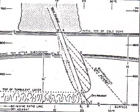
21 Skew-T Log-P Diagram We know convection exists, but have we thought about what is required to develop convection Let s talk about this stability diagram Parcel Negative area Energy input Think back to water vapor and its variation
22 Analysis of perturbation form of vertical equation of motion δ(w 2 /2) = -g (ΔT/T) δz Integrate from bottom where w=max to top w=x (w b w t ) = {(2g (ΔT/T) (z t z b )} 1/2 For example if ΔT = 0.5 C, with an average environmental T of 290 C over a height of 290 meters, with a w of 0.1 m/s at the top, then w input at the base is approximately 3.4 m/s: how can this come about? The example is not from this skew-t which is only used to remind you of the negative area (LCL to LFC) that must be overcome to get free convection
23 Analysis of perturbation form of vertical equation of motion δ(w 2 /2) = -g (ΔT/T) δz Integrate from bottom where w=max to top w=x (w b w t ) = {(2g (ΔT/T) (z t z b )} 1/2 For example if ΔT = 0.5 C, with an average environmental T of 290 C over a height of 290 meters, with a w of 0.1 m/s at the top, then w input at the base is approximately 3.4 m/s: how can this come about? Localized forcing in organized convergence zones integrated over time The example is not from this skew-t which is only used to remind you of the negative area (LCL to LFC) that must be overcome to get free convection
24 Organized circulation Vorticity - On the local scale Convergence on preexisting vorticity Tilting of vorticity from one plane to another Advection from one place to another Differential heating (does not require preexisting vorticity) Friction
25 Differential heating examples When one thinks of differential heating the land sea breeze phenomena immediately comes to mind, as do mountain and valley breezes. Another differential heating mechanism, to be addressed later, is the thunderstorm itself: through evaporation of rain cooled air a differential heating is developed in a quick and often dramatic fashion.
26 Example of Sea-breeze development (movie next page) lake lake River River
27 Example of Sea-breeze development lake lake River River
28 Example of Sea-breeze development (movie next page) peninsula

29 Example of Sea-breeze development peninsula


30 Example of early morning GOES image showing convection along the night time land breeze front. Note coastal curvature effect.

31 Example of mountain effect on convective development. Note the cumulus over the peaks and compensating subsidence areas.

32 Example of the effect of river breezes in organizing convection As with sea breezes, differential heating may play a role in river breeze development. However with rivers their size (the meandering river system) and the prevailing low level flow become very important.

33 In conditions with light winds, areas of early morning cloud cover can effect afternoon cumulus development due to differential heating between the cloudy and clear regions. Care must be taken in this generalization, as the time of early cloud erosion is crucial in determining that areas ability to support convection later in the day.
34 The importance of low level flow with respect to organized convergence zones The flow of the air in the boundary layer with respect to the orientation of the convergence zone is important in allowing the parcels to realize their potential to move vertically and eventually form storms. If low level air moves too rapidly through a convergence zone it may not rise enough to produce even cumulus cloudiness!

35 Cumulus development and low level flow with respect to convergence zones over a small island
36 Cumulus development and low level flow with respect to convergence zones over a small island Movie on next page. Note the low level flow and development of strong convection as the air remains in the convergence zone
37 Cumulus development and low level flow with respect to convergence zones over a small island Note the low level flow and development of strong convection as the air remains in the convergence zone

38 Convection over Yucatan down wind from organized convective line

39 The effect of low level wind flow (boundary layer) on convective development is illustrated by using this slide with the next two slides.

40 In this large view note the cumulus blowing off shore in Northern Australia. The following slide is over a longer time period and concentrates on the Northern half of the image.

41 Close up of Northern half of previous movie.

42 Favored area for stronger convection development: Merging Convective Lines


43 Satellite derived cloud climatologies are often useful in helping understand the effect of local terrain on convective development. This is the subject of an entire lecture in the Virtual resource Library

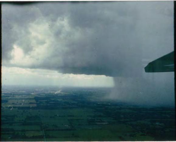
44 Thunderstorm development and evolution


45 Photo from manned space craft Expansion of inset to right Note that deep convection is confined to lines and favored where the lines intersect. Also note how clear it is within the interior of some convective regions.
46 Animation of one minute GOES imagery illustrating the role of storm outflow in generating new convection.

47


48 A flight through an arc cloud line
49 Aircraft data from penetration of an intense arc cloud s sub-cloud region
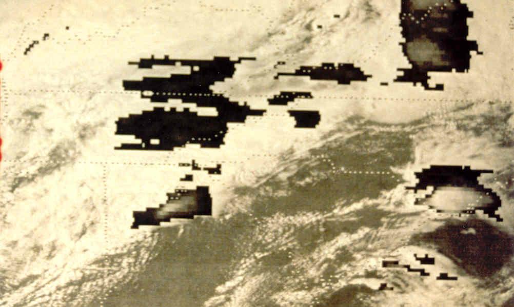
50 Conceptual model, based on aircraft flights, of the arc cloud line, its parent thunderstorm and the density surge line (DSL).
51 Thunderstorm Outflow Boundaries They appear as narrow cumulus lines (on a satellite image) as they advance away from the parent convective region What can you determine from the state of the convection that forms along an outflow boundary What causes new thunderstorm development along some parts of an outflow boundary but not others?
52 Convergence and vertical motion region associated with the arc cloud
53 Conceptual model of arc cloud line interacting with organized cumulus region
54 Age of the outflow What happens to outflow boundaries as a function of time? How can they maintain themselves? What role might vorticity play? What about new showers? What happens when outflows merge? Recall the earlier image from a manned spacecraft. What was evident where boundaries merged?

55 Arc cloud line moving northward from a large convective region over the Gulf of Mexico
.")
56 Two hours later the arc cloud line has moved ashore triggering new convection (in preferred locations).

57 Multiple exposure over time of arc cloud line shown in previous images, which were just two of a sequence. Notice changes in distance between arcs and their cumulus
58 What would a mesoscale analysis of this data look like?
59 Satellite data guides the mesoscale analysis with mesoscale reasoning
60 Note where the convection forms: Convective Scale Interaction

61 Notice how well the cloud field can be analyzed with 250 meter resolution MODIS imagery: here we see the effect of the process.
 and MODIS true color image near 1615 (right).")
62 Observing the process (geostationary) can help analyze polar imagery. GOES-8 loop from 1033 to 1615 (left) and MODIS true color image near 1615 (right). While noting the convection over land, pay attention to convection over the ocean.
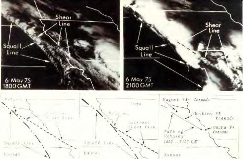
63 GOES-8 loop for entire day and MODIS true color image near 1615 (right). While noting the convection over land, pay exceptional attention to convection over the ocean.
64 Recent Observations from MSG Observations of outflow boundaries over Saharan Africa reveal that many dust storms are the result of thunderstorm rainfall into relatively dry air. The dust within the rain-cooled outflow air can be followed using the multi-spectral capabilities of MSG infrared channels at 8.6, 10 and 12 microns. The persistence of these boundaries and their moistened air leads to convective regeneration due to the earlier thunderstorm activity. This is illustrated in the next four slides, the final one in animations.


65 Rainfall raising dust squalls Dust squalls triggering rain clouds


66 1.6 μm 0.8 μm 0.6 μm MSG :00

 10.")
67 μm μm 10.8 μm μm Dust more red: Dust has negative μm BTD μm Dust less green on desert background with low ε(8.7) 10.8 μm Dust less blue: Colder than the desert surface MSG :00

68
69 Please read accompanying notes section before proceeding with presentation. Detailed notes are not necessarily included with each slide. Some principals may be generalized while others require caution. Large scale forcing, convergence zones and organized convection A short section on large scale forcing and development of storms along synoptic scale convergence zones follows. It focuses on mid-latitude systems, although some of the principles hold for tropical systems.. Also included is a discussion on over shooting storm tops and anvil cloud top characteristics This serves as a lead in for using infrared imagery identifying stronger convection and storms that are likely to be producing heaver rainfall
 and GOES-West (left).")
70 Organized line of cumulus and cumulus congestus are being generated along a well organized convergence zone, with a well formed thunderstorm along that line. Note the difference in perspective when viewing the thunderstorm with GOES East (right) and GOES-West (left). The formation of cumulus along organized convergence lines such as fronts and pre-frontal troughs prior to thunderstorm development is a common feature that allows for better nowcasting of squall line development.


71 Numerous studies have highlighted the importance of knowing the disribution of water vapor in predicting convective development and evolution. The location where convection initiates is denoted by the upward bulge in the isopleths of mixing ratio (q) and θ [E].

72 GOES-West view of organized cumulus convection along convergence zone ABCD, with convection being triggered at B by gravity wave EF
 and")
73 Developed squall line (from GOES East) and tornado
74 Nowcasting requires information on mesoscale thermodynamic structure of atmosphere, cloud type and vertical wind shear Important for Nowcasting Convection and Severe Weather Vertical wind shear Evolving instability field Strength of storm produced cold pool Updraft strength Anvil characteristics Development Temperature structure Storm-environment interaction Cloud top rotation Storm damage

75 Thunderstorms developing along a cold front. Note the organization of the developing squall line as well as the cloud field ahead of it.
76 April 21, 1991 Tornado Outbreak 2 km visible Z Earth Relative Motion Main severe outbreak across Kansas & Oklahoma Note cirrus motion and squall line development

77 April 21, 1991 Tornado Outbreak 1 km visible zoomed to ½ km scale Z Earth Relative Motion Across Kansas & Oklahoma boarder Note cumulus flow, overshooting tops and cirrus motions

78 1 km visible zoomed to ½ km scale Z Storm Relative Motion Across Kansas & Oklahoma boarder Note low level moist flow and shear in cloud layer relative to developing storms and storm effect on low level environment April 21, 1991 Tornado Outbreak

79 1 km visible Z Storm Relative Motion Across Kansas & Oklahoma boarder Note low level moist flow and shear in cloud layer relative to developing storms and storm effect on low level environment April 21, 1991 Tornado Outbreak

80 April 21, 1991 Tornado Outbreak 1 km visible Z Cirrus Relative Motion Note storm effect on upper flow

81 One minute visible imagery of severe storms. Note the cumulus in the warm sector: this appearance is typical of cumulus capped by an inversion layer. The other capping layer is the tropopause: note the overshooting tops and long plumes of downstream cirrus above the anvil (typical for a long lived super-cell).
82 Vorticity - On the local scale Helping a storm become severe Convergence on preexisting vorticity Tilting of vorticity from one plane to another Advection from one place to another Differential heating Friction


83 Severe Storms Like Boundaries Interaction along a boundary depends on both the storm s and boundaries characteristics
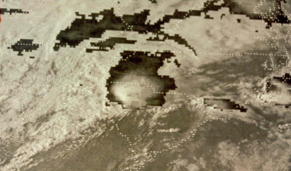


84

85 Conceptual model of storm interacting with preexisting boundary. As the storm moves along the boundary low level vorticity along the boundary is tilted into the plane of the thunderstorms updraft where it undergoes stretching in the vertical.

. Figure 14.")
86 One minute interval GOES imagery Conceptual model: severe thunderstorm Conceptual model of a super cell severe thunderstorm that interacts with and modifies its local environment, leading to its becoming severe (see also accompanying text). Figure 14. Early (top) and mature (bottom) stages of supercell s life..


87 Wichita Falls, TX tornadic storm at 2345 GMT, Apr 10, 79 Wichita Falls, TX tornadic storm, 30 minutes later
88 Wichita Falls, TX tornadic storm at 2345 GMT, Apr 10, 79
89 Wichita Falls, TX tornadic storm at 0015 GMT, Apr 11, 79

90 Imagery and sounder data Instability field from GOES over severe storm area and severe storm at one minute interval (right)
91 The Nature of Convective Development and Evolution Differs Between Daytime and Nighttime The afternoon initiation episodes were primarily surface based and the nocturnal were elevated. The surface-based initiations occurred mostly during the afternoon and early evening, and the elevated initiations during the night and early morning. Wilson and Roberts, 2002: Summary of Convective Storm Initiation and Evolution during IHOP: Observational and Modeling Perspective. Monthly Weather Review: Vol. 134, No. 1, pp

92 Viewing dry and moist boundary layers daytime to night
 Detection of inversions is critical for severe weather forecasting.")
93 Brightness Temperature (K) Detection of Temperature Inversions Possible with Hyperspectral IR Texas Ontario Wavenumber (cm -1 ) Spikes down - cooling with height (No inversion) Spikes up - warming with height (low-level inversion) Detection of inversions is critical for severe weather forecasting. Combined with improved low-level moisture depiction, key ingredients for night-time severe storm development can be monitored.


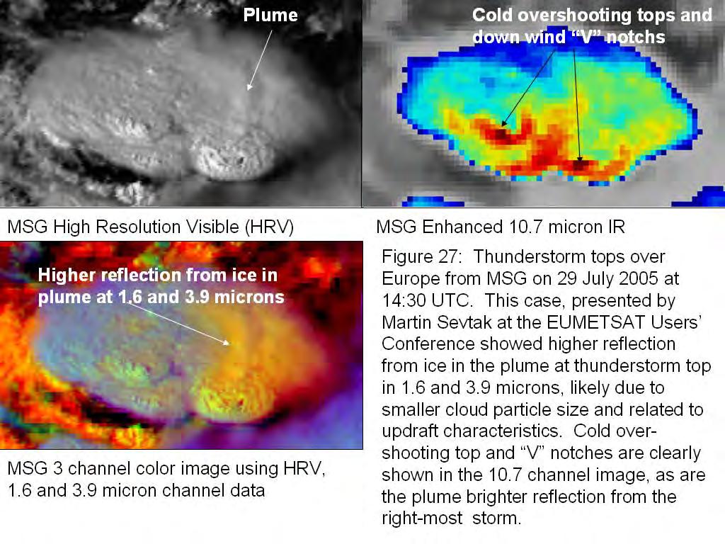
94 Storm cloud top structure as a proxy for severe weather and heavy rainfall

95 Comparison of cloud top for Jarrel, Texas, tornadic storm with GOES on left and AVHRR on right.


96 Different characteristics of anvils and overshooting tops are revealed by using different channels. Shown here are AVHRR visible (upper left), 3.7 microns (upper right with special enhancement across anvil top) and 10.7 micron IR
97
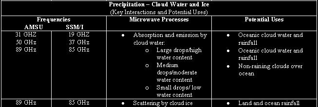
98 Rainfall Infrared techniques Precipitation rates are primarily estimated from cloud top temperature. Numerous other factors, including the cloud-top geometry, the available atmospheric moisture, stability parameters, radar, and local topography, are used to further adjust the rain rate. Microwave techniques Precipitation rates are primarily based on microwave scattering by cloud ice and absorption and emission by cloud water. Blended techniques generally use information from microwave sensors as a baseline to help calibrate rainfall estimations from infrared sensors.

99
 where half hourly infrared images over a two hour period ending at 1445 GMT were")
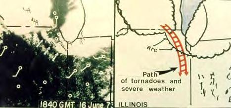
100 Sometimes a simple average of sequential geostationary infrared images over a few hours will reveal areas of heavy persistent rainfall In this example heavy convective rainfall occurred over Illinois (green) where half hourly infrared images over a two hour period ending at 1445 GMT were averaged.


101 Near real time rainfall and rain rate products are available from the Web Based Products link on the VRL
 for products, algorithms, tutorials and more!")
102 There is also a link on the VRL to the International Precipitation Working Group (IPWG) for products, algorithms, tutorials and more!
1 of 7 Thunderstorm Notes by Paul Sirvatka College of DuPage Meteorology. Thunderstorms
 1 of 7 Thunderstorm Notes by Paul Sirvatka College of DuPage Meteorology Thunderstorms There are three types of thunderstorms: single-cell (or air mass) multicell (cluster or squall line) supercell Although
Practical Use of the Skew-T, log-p diagram for weather forecasting. Primer on organized convection
 Practical Use of the Skew-T, log-p diagram for weather forecasting Primer on organized convection Outline Rationale and format of the skew-t, log-p diagram Some basic derived diagnostic measures Characterizing
Advanced Spotter Training Lesson 4: The Nature of Thunderstorms
 Advanced Spotter Training 2009 Lesson 4: The Nature of Thunderstorms From Last Time We discussed the different ways to make air rise. We discussed convection, convergence, and the different kinds of fronts.
Air Mass Thunderstorms. Air Mass Thunderstorms. Air Mass Thunderstorms. Lecture 26 Air Mass Thunderstorms and Lightning
 Lecture 26 and Lightning Life Cycle Environment Climatology Lightning 1 2 Short-lived, isolated thunderstorms that are not severe are often called air-mass thunderstorms. There are three stages describing
Reading. What meteorological conditions precede a thunderstorm? Thunderstorms: ordinary or single cell storms, multicell storms, supercell storms
 Thunderstorms: ordinary or single cell storms, multicell storms, supercell storms Reading Ahrens, Chapter 14: Thunderstorms and Tornadoes This lecture + next (Lightning, tornadoes) will cover the topic.
Science Olympiad Meteorology Quiz #2 Page 1 of 8
 1) The prevailing general direction of the jet stream is from west to east in the northern hemisphere: 2) Advection is the vertical movement of an air mass from one location to another: 3) Thunderstorms
Chapter 8 cont. Clouds and Storms
 Chapter 8 cont. Clouds and Storms Spring 2007 Clouds and Storms Clouds cover ~ 50% of earth at any time. Clouds are linked to a number of condensation processes. Cloud morphology, cloud types, associated
Chapter 8 cont. Clouds and Storms. Spring 2018
 Chapter 8 cont. Clouds and Storms Spring 2018 Clouds and Storms Clouds cover ~ 50% of earth at any time. Clouds are linked to a number of condensation processes. Cloud morphology, cloud types, associated
TOPICS: What are Thunderstorms? Ingredients Stages Types Lightning Downburst and Microburst
 THUNDERSTORMS TOPICS: What are Thunderstorms? Ingredients Stages Types Lightning Downburst and Microburst What are Thunderstorms? A storm produced by a cumulonimbus cloud that contains lightning and thunder
The Earth System - Atmosphere III Convection
 The Earth System - Atmosphere III Convection Thunderstorms 1. A thunderstorm is a storm that produces lightning (and therefore thunder) 2. Thunderstorms frequently produce gusty winds, heavy rain, and
Chapter 14 Thunderstorm Fundamentals
 Chapter overview: Thunderstorm appearance Thunderstorm cells and evolution Thunderstorm types and organization o Single cell thunderstorms o Multicell thunderstorms o Orographic thunderstorms o Severe
CLOUDS & THUNDERSTORMS
 Funding provided by NOAA Sectoral Applications Research Project CLOUDS & THUNDERSTORMS Basic Climatology Oklahoma Climatological Survey How are clouds made? Clouds form when air is cooled to its dewpoint
Atmospheric Motions Derived From Space Based Measurements: A Look To The Near Future. James F.W. Purdom
 Atmospheric Motions Derived From Space Based Measurements: A Look To The Near Future James F.W. Purdom Director, Office of Research and Applications NOAA/NESDIS 1. Introduction This short note addresses
Tornadogenesis in Supercells: The Three Main Ingredients. Ted Funk
 Tornadogenesis in Supercells: The Three Main Ingredients Ted Funk NWS Louisville, KY Spring 2002 Environmental Parameters Supercells occur within environments exhibiting several wellknown characteristics
Weather Systems III: Thunderstorms and Twisters
 Weather Systems III: Thunderstorms and Twisters Review 1. Definition of airmasses? Bergeron classification of air masses 2. Surface weather analysis: Station model, wind speed code, present weather 3.
Anthony A. Rockwood Robert A. Maddox
 Anthony A. Rockwood Robert A. Maddox An unusually intense MCS produced large hail and wind damage in northeast Kansas and northern Missouri during the predawn hours of June 7 th, 1982. Takes a look at
Meteorology Lecture 18
 Meteorology Lecture 18 Robert Fovell rfovell@albany.edu 1 Important notes These slides show some figures and videos prepared by Robert G. Fovell (RGF) for his Meteorology course, published by The Great
ANSWER KEY. Part I: Synoptic Scale Composite Map. Lab 12 Answer Key. Explorations in Meteorology 54
 ANSWER KEY Part I: Synoptic Scale Composite Map 1. Using Figure 2, locate and highlight, with a black dashed line, the 500-mb trough axis. Also, locate and highlight, with a black zigzag line, the 500-mb
Moisture, Clouds, and Precipitation: Clouds and Precipitation. Dr. Michael J Passow
 Moisture, Clouds, and Precipitation: Clouds and Precipitation Dr. Michael J Passow What Processes Lift Air? Clouds require three things: water vapor, a condensation nucleus, and cooling Cooling usually
ESCI 344 Tropical Meteorology Lesson 7 Temperature, Clouds, and Rain
 ESCI 344 Tropical Meteorology Lesson 7 Temperature, Clouds, and Rain References: Forecaster s Guide to Tropical Meteorology (updated), Ramage Tropical Climatology, McGregor and Nieuwolt Climate and Weather
HAZARDOUS WEATHER 1. Dr. Julie Laity Geography 266
 HAZARDOUS WEATHER 1 Dr. Julie Laity Geography 266 Violent Weather Thunderstorms Atmospheric turbulence Lightning and thunder Hail Derechos Tornadoes Tornado measurement and science Tropical Cyclones Hurricanes
Lecture 19: Operational Remote Sensing in Visible, IR, and Microwave Channels
 MET 4994 Remote Sensing: Radar and Satellite Meteorology MET 5994 Remote Sensing in Meteorology Lecture 19: Operational Remote Sensing in Visible, IR, and Microwave Channels Before you use data from any
Type of storm viewed by Spotter A Ordinary, multi-cell thunderstorm. Type of storm viewed by Spotter B Supecell thunderstorm
 ANSWER KEY Part I: Locating Geographical Features 1. The National Weather Service s Storm Prediction Center (www.spc.noaa.gov) has issued a tornado watch on a warm spring day. The watch covers a large
CHAPTER 11 THUNDERSTORMS AND TORNADOES MULTIPLE CHOICE QUESTIONS
 CHAPTER 11 THUNDERSTORMS AND TORNADOES MULTIPLE CHOICE QUESTIONS 1. A thunderstorm is considered to be a weather system. a. synoptic-scale b. micro-scale c. meso-scale 2. By convention, the mature stage
Talking points for Basic Satellite Interpretation in the Tropics
 Talking points for Basic Satellite Interpretation in the Tropics 1. Title. This training session is based on the NESDIS workbook Tropical Clouds and Cloud Systems Observed in Satellite Imagery by Vernon
Storm and Storm Systems Related Vocabulary and Definitions. Magnitudes are measured differently for different hazard types:
 Storm and Storm Systems Related Vocabulary and Definitions Magnitude: this is an indication of the scale of an event, often synonymous with intensity or size. In natural systems, magnitude is also related
The Jarrell Tornado of May 27, 1997
 The Jarrell Tornado of May 27, 1997 ANDREW MANKOWSKI University of Wisconsin Madison Atmospheric and Oceanic Sciences ABSTRACT A tornado outbreak occurred over Central Texas on May 27, 1997. This outbreak
SATELLITE SIGNATURES ASSOCIATED WITH SIGNIFICANT CONVECTIVELY-INDUCED TURBULENCE EVENTS
 SATELLITE SIGNATURES ASSOCIATED WITH SIGNIFICANT CONVECTIVELY-INDUCED TURBULENCE EVENTS Kristopher Bedka 1, Wayne Feltz 1, John Mecikalski 2, Robert Sharman 3, Annelise Lenz 1, and Jordan Gerth 1 1 Cooperative
Mid-Latitude Cyclones and Fronts. Lecture 12 AOS 101
 Mid-Latitude Cyclones and Fronts Lecture 12 AOS 101 Homework 4 COLDEST TEMPS GEOSTROPHIC BALANCE Homework 4 FASTEST WINDS L Consider an air parcel rising through the atmosphere The parcel expands as it
Impacts of the April 2013 Mean trough over central North America
 Impacts of the April 2013 Mean trough over central North America By Richard H. Grumm National Weather Service State College, PA Abstract: The mean 500 hpa flow over North America featured a trough over
Mechanical Turbulence Wind forms eddies as it blows around hanger, stands of trees or other obstructions
 Turbulence Low-level Turbulence below 15,000 feet consists of Mechanical Turbulence Convective Turbulence Frontal Turbulence Wake Turbulence Mechanical Turbulence Wind forms eddies as it blows around hanger,
Weather and the Atmosphere. RAP Short Course
 Weather and the Atmosphere RAP Short Course Syllabus 1) Vertical structure and composition of the atmosphere, basic weather variables 2) Warming Earth and its atmosphere the diurnal and seasonal cycles
Guided Notes Weather. Part 2: Meteorology Air Masses Fronts Weather Maps Storms Storm Preparation
 Guided Notes Weather Part 2: Meteorology Air Masses Fronts Weather Maps Storms Storm Preparation The map below shows North America and its surrounding bodies of water. Country borders are shown. On the
Charles A. Doswell III, Harold E. Brooks, and Robert A. Maddox
 Charles A. Doswell III, Harold E. Brooks, and Robert A. Maddox Flash floods account for the greatest number of fatalities among convective storm-related events but it still remains difficult to forecast
Oakfield, WI Tornado of July 18 th, 1996: "Everything in its Right Place"
 Oakfield, WI Tornado of July 18 th, 1996: "Everything in its Right Place" Arian Sarsalari Department of Atmospheric and Oceanic Sciences, University of Wisconsin Madison ABSTRACT This paper will serve
AIR MASSES. Large bodies of air. SOURCE REGIONS areas where air masses originate
 Large bodies of air AIR MASSES SOURCE REGIONS areas where air masses originate Uniform in composition Light surface winds Dominated by high surface pressure The longer the air mass remains over a region,
Chapter 3 Convective Dynamics 3.4. Bright Bands, Bow Echoes and Mesoscale Convective Complexes
 Chapter 3 Convective Dynamics 3.4. Bright Bands, Bow Echoes and Mesoscale Convective Complexes Photographs Todd Lindley Bright band associated with stratiform precipitation in a squall line system 1 Bright
Air Masses, Fronts, Storm Systems, and the Jet Stream
 Air Masses, Fronts, Storm Systems, and the Jet Stream Air Masses When a large bubble of air remains over a specific area of Earth long enough to take on the temperature and humidity characteristics of
Foundations of Earth Science, 6e Lutgens, Tarbuck, & Tasa
 Foundations of Earth Science, 6e Lutgens, Tarbuck, & Tasa Weather Patterns and Severe Weather Foundations, 6e - Chapter 14 Stan Hatfield Southwestern Illinois College Air masses Characteristics Large body
Lec 10: Interpreting Weather Maps
 Lec 10: Interpreting Weather Maps Case Study: October 2011 Nor easter FIU MET 3502 Synoptic Hurricane Forecasts Genesis: on large scale weather maps or satellite images, look for tropical waves (Africa
11A.2 Forecasting Short Term Convective Mode And Evolution For Severe Storms Initiated Along Synoptic Boundaries
 11A.2 Forecasting Short Term Convective Mode And Evolution For Severe Storms Initiated Along Synoptic Boundaries Greg L. Dial and Jonathan P. Racy Storm Prediction Center, Norman, Oklahoma 1. Introduction
Tropical Cyclones. Objectives
 Tropical Cyclones FIU Undergraduate Hurricane Internship Lecture 2 8/8/2012 Objectives From this lecture you should understand: Global tracks of TCs and the seasons when they are most common General circulation
Thunderstorm: a cumulonimbus cloud or collection of cumulonimbus clouds featuring vigorous updrafts, precipitation and lightning
 Thunderstorm: a cumulonimbus cloud or collection of cumulonimbus clouds featuring vigorous updrafts, precipitation and lightning Thunderstorm: a cumulonimbus cloud or collection of cumulonimbus clouds
10/21/2012. Chapter 10 Thunderstorms. Part II. Growth and Development of ordinary Cell Thunderstorms Thunderstorm Electrification.
 Chapter 10 Thunderstorms Part I Growth and Development of ordinary Cell Thunderstorms Thunderstorm Electrification Tornadoes Part II Simplified model depicting the life cycle of an ordinary thunderstorm
 http://www.ssec.wisc.edu/data/composites.html Red curve: Incoming solar radiation Blue curve: Outgoing infrared radiation. Three-cell model of general circulation Mid-latitudes: 30 to 60 latitude MID-LATITUDES
Page 1. Name:
 Name: 1) As the difference between the dewpoint temperature and the air temperature decreases, the probability of precipitation increases remains the same decreases 2) Which statement best explains why
Thunderstorm: a cumulonimbus cloud or collection of cumulonimbus clouds featuring vigorous updrafts, precipitation and lightning
 Thunderstorm: a cumulonimbus cloud or collection of cumulonimbus clouds featuring vigorous updrafts, precipitation and lightning Thunderstorms are responsible for most of what we refer to as severe weather,
Talking points for Water Vapor Imagery Analysis for Severe Thunderstorm Forecasting.
 Talking points for Water Vapor Imagery Analysis for Severe Thunderstorm Forecasting. 1. Title. 2. Learning objectives. These are the topics we ll consider during this training session, the goal of the
1st Tornado Photograph
 Lecture 26 Part II Tornados Environment Storm Structure Life Cycle Source of Spin Forecasting Climatology Damage Marilee Thomas of Beaver City, NE took this photograph of her daughter Audra about two miles
Updated 12 Sep 2002 Talking Points for VISITview Lesson Fog Detection and Analysis With Satellite Data Gary Ellrod (NOAA/NESDIS) 1.
 1.") Updated 12 Sep 2002 Talking Points for VISITview Lesson Fog Detection and Analysis With Satellite Data Gary Ellrod (NOAA/NESDIS) 1. Title 2. Fog has a major impact on air safety and efficiency, and may
Updated 12 Sep 2002 Talking Points for VISITview Lesson Fog Detection and Analysis With Satellite Data Gary Ellrod (NOAA/NESDIS) 1. Title 2. Fog has a major impact on air safety and efficiency, and may
1. Which weather map symbol is associated with extremely low air pressure? A) B) C) D) 2. The diagram below represents a weather instrument.
 B) C) D) 2. The diagram below represents a weather instrument.") 1. Which weather map symbol is associated with extremely low air pressure? 2. The diagram below represents a weather instrument. Which weather variable was this instrument designed to measure? A) air pressure
1. Which weather map symbol is associated with extremely low air pressure? 2. The diagram below represents a weather instrument. Which weather variable was this instrument designed to measure? A) air pressure
Evolution and Maintenance of the June 2003 Nocturnal Convection
 Evolution and Maintenance of the 22-23 June 2003 Nocturnal Convection Jerilyn Billings NOAA/NWS Wichita, KS August 6 th, 2011 Work Completed at North Carolina State University for MS Thesis During the
ATS 351, Spring 2010 Lab #11 Severe Weather 54 points
 ATS 351, Spring 2010 Lab #11 Severe Weather 54 points Question 1 (10 points): Thunderstorm development a) Sketch and describe the stages of development of a single cell thunderstorm. About how long does
STATISTICAL ANALYSIS ON SEVERE CONVECTIVE WEATHER COMBINING SATELLITE, CONVENTIONAL OBSERVATION AND NCEP DATA
 12.12 STATISTICAL ANALYSIS ON SEVERE CONVECTIVE WEATHER COMBINING SATELLITE, CONVENTIONAL OBSERVATION AND NCEP DATA Zhu Yaping, Cheng Zhoujie, Liu Jianwen, Li Yaodong Institute of Aviation Meteorology
Activity: A Satellite Puzzle
 Activity: A Satellite Puzzle Introduction Satellites provide unique views of Earth. The imagery acquired by these space platforms reveal weather systems and broad-scale circulation patterns that can be
Weather. Chapter Test A. Multiple Choice. Write the letter of the correct answer on the line at the left.
 Weather Chapter Test A Multiple Choice Write the letter of the correct answer on the line at the left. 1. The most dangerous aspect of a snowstorm is often the a. high winds. b. depth of snow. c. brightness.
Basic cloud Interpretation using Satellite Imagery
 Basic cloud Interpretation using Satellite Imagery Introduction Recall that images from weather satellites are actually measurements of energy from specified bands within the Electromagnetic (EM) spectrum.
DEPARTMENT OF EARTH & CLIMATE SCIENCES NAME SAN FRANCISCO STATE UNIVERSITY Fall ERTH FINAL EXAMINATION KEY 200 pts
 DEPARTMENT OF EARTH & CLIMATE SCIENCES NAME SAN FRANCISCO STATE UNIVERSITY Fall 2016 Part 1. Weather Map Interpretation ERTH 365.02 FINAL EXAMINATION KEY 200 pts Questions 1 through 9 refer to Figure 1,
Thunderstorms and Severe Weather. (Chapt 15)
") Thunderstorms and Severe Weather (Chapt 15) The Big Picture We ve emphasized horizontal transport of energy to balance the planetary energy budget: Hadley Cell Subtropical divergence Midlatitude cyclones
Thunderstorms and Severe Weather (Chapt 15) The Big Picture We ve emphasized horizontal transport of energy to balance the planetary energy budget: Hadley Cell Subtropical divergence Midlatitude cyclones
severe VOLUME 5, NUMBER 1, FEBRUARY 1980
 severe VOLUME 5, NUMBER 1, FEBRUARY 1980 TORNADIC THUNDERSTORM DEVELOPMENT IN WEST TEXAS 27 MAY 1978 by Richard E. Peterson Atmospheric Science Group Texas University Lubbock, TX and Alan Johnson National
Weather Notes. Chapter 16, 17, & 18
 Weather Notes Chapter 16, 17, & 18 Weather Weather is the condition of the Earth s atmosphere at a particular place and time Weather It is the movement of energy through the atmosphere Energy comes from
Detailed Cloud Motions from Satellite Imagery Taken at Thirty Second One and Three Minute Intervals
 Detailed Cloud Motions from Satellite Imagery Taken at Thirty Second One and Three Minute Intervals James F.W. Purdom NOAA/NESDIS/RAMM Branch CIRA Colorado State University W. Laporte Avenue Fort Collins,
Examination #3 Wednesday, 28 November 2001
 Name & Signature Dr. Droegemeier Student ID Meteorology 1004 Introduction to Meteorology Fall, 2001 Examination #3 Wednesday, 28 November 2001 BEFORE YOU BEGIN!! Please be sure to read each question CAREFULLY
p = ρrt p = ρr d = T( q v ) dp dz = ρg
 dp dz = ρg") Chapter 1: Properties of the Atmosphere What are the major chemical components of the atmosphere? Atmospheric Layers and their major characteristics: Troposphere, Stratosphere Mesosphere, Thermosphere
Chapter 1: Properties of the Atmosphere What are the major chemical components of the atmosphere? Atmospheric Layers and their major characteristics: Troposphere, Stratosphere Mesosphere, Thermosphere
Divergence, Spin, and Tilt. Convergence and Divergence. Midlatitude Cyclones. Large-Scale Setting
 Midlatitude Cyclones Equator-to-pole temperature gradient tilts pressure surfaces and produces westerly jets in midlatitudes Waves in the jet induce divergence and convergence aloft, leading to surface
A Description of Convective Weather Containing Ice Crystals Associated with Engine Powerloss and Damage
 A Description of Convective Weather Containing Ice Crystals Associated with Engine Powerloss and Damage The Boeing Company 1 Photo: courtesy of Ian McPherson The Boeing Company acknowledges the contributions
T-re Plots Generated from MSG Data in Severe Storms Forecasting Testing in Central Europe
 WDS'11 Proceedings of Contributed Papers, Part III, 88 92, 2011. ISBN 978-80-7378-186-6 MATFYZPRESS T-re Plots Generated from MSG Data in Severe Storms Forecasting Testing in Central Europe M. Pokorný
SATELLITE MONITORING OF THE CONVECTIVE STORMS
 SATELLITE MONITORING OF THE CONVECTIVE STORMS FORECASTERS POINT OF VIEW Michaela Valachová, EUMETSAT Workshop at ECMWF User Meeting Reading, 13 June 2017 Central Forecasting Office, Prague michaela.valachova@chmi.cz
Practical Atmospheric Analysis
 Chapter 12 Practical Atmospheric Analysis With the ready availability of computer forecast models and statistical forecast data, it is very easy to prepare a forecast without ever looking at actual observations,
Meteorology. Chapter 10 Worksheet 2
 Chapter 10 Worksheet 2 Meteorology Name: Circle the letter that corresponds to the correct answer 1) Downdrafts totally dominate the in the development of a thunderstorm. a) dissipating stage b) mature
Kenneth L. Pryor* and Gary P. Ellrod Center for Satellite Applications and Research (NOAA/NESDIS) Camp Springs, MD
 Camp Springs, MD") P1.57 GOES WMSI PROGRESS AND DEVELOPMENTS Kenneth L. Pryor* and Gary P. Ellrod Center for Satellite Applications and Research (NOAA/NESDIS) Camp Springs, MD 1. INTRODUCTION A multi-parameter index has
P1.57 GOES WMSI PROGRESS AND DEVELOPMENTS Kenneth L. Pryor* and Gary P. Ellrod Center for Satellite Applications and Research (NOAA/NESDIS) Camp Springs, MD 1. INTRODUCTION A multi-parameter index has
What a Hurricane Needs to Develop
 Weather Weather is the current atmospheric conditions, such as air temperature, wind speed, wind direction, cloud cover, precipitation, relative humidity, air pressure, etc. 8.10B: global patterns of atmospheric
Meteorology Lecture 19
 Meteorology Lecture 19 Robert Fovell rfovell@albany.edu 1 Important notes These slides show some figures and videos prepared by Robert G. Fovell (RGF) for his Meteorology course, published by The Great
April 13, 2006: Analysis of the Severe Thunderstorms that produced Hail in Southern Wisconsin
 April 13, 2006: Analysis of the Severe Thunderstorms that produced Hail in Southern Wisconsin Danielle Triolo UW Madison Undergraduate 453 Case Study May 5, 2009 ABSTRACT On April 13, 2006 the states of
Meteorology Today. 1 Aug st Lt Libby Haynes Capt Kim Mevers
 Meteorology 1950 - Today 1 Aug 2018 1 st Lt Libby Haynes Capt Kim Mevers What is meteorology? Is it important to you? Meteorology is the science of the atmosphere embracing both weather and climate. It
Feel free to ask me if you are confused about the meaning of any question. Good luck, and have a great spring break!
 Name: _ MEA 214 Midterm Exam, Spring 2011 Feel free to ask me if you are confused about the meaning of any question. Good luck, and have a great spring break! 1.) For each of the characteristics listed
AOMSUC-6 Training Event
 Effective use of high temporal and spatial resolution Himawari-8 data AOMSUC-6 Training Event Bodo Zeschke Australian Bureau of Meteorology Training Centre Australian VLab Centre of Excellence Content
ESCI 344 Tropical Meteorology Lesson 11 Tropical Cyclones: Formation, Maintenance, and Intensification
 ESCI 344 Tropical Meteorology Lesson 11 Tropical Cyclones: Formation, Maintenance, and Intensification References: A Global View of Tropical Cyclones, Elsberry (ed.) Global Perspectives on Tropical Cylones:
Weather report 28 November 2017 Campinas/SP
 Weather report 28 November 2017 Campinas/SP Summary: 1) Synoptic analysis and pre-convective environment 2) Verification 1) Synoptic analysis and pre-convective environment: At 1200 UTC 28 November 2017
Thunderstorms. Ordinary Cell Thunderstorms. Ordinary Cell Thunderstorms. Ordinary Cell Thunderstorms 5/2/11
 A storm containing lightning and thunder; convective storms Chapter 14 Severe thunderstorms: At least one: large hail wind gusts greater than or equal to 50 kt Tornado 1 2 Ordinary Cell Ordinary Cell AKA
Pilots watch the clouds, because clouds can indicate the kind of weather in store for a flight.
 Low stratus Cumulonimbus Pilots watch the clouds, because clouds can indicate the kind of weather in store for a flight. FILL IN THE BLANKS OR CIRCLE ONE: A. Stratus means flat or on one level. Low stratus
Weather Studies Introduction to Atmospheric Science
 Weather Studies Introduction to Atmospheric Science American Meteorological Society Chapter 1 Monitoring The Weather Credit: This presentation was prepared for AMS by Michael Leach, Professor of Geography
What do you think of when someone says weather?
 Weather Our World: What is Weather? video What do you think of when someone says weather? Questions from Bill Nye video 1. What causes wind? 2. What are two things that were mentioned by Bill Nye that
Chapter 24. Tropical Cyclones. Tropical Cyclone Classification 4/19/17
 Chapter 24 Tropical Cyclones Tropical Cyclones Most destructive storms on the planet Originate over tropical waters, but their paths often take them over land and into midlatitudes Names Hurricane (Atlantic
Air Mass. 1. Air Mass : Large body of Air with similar temperature and humidity (or moisture) ; 4 types
 ; 4 types") Air Mass 1. Air Mass : Large body of Air with similar temperature and humidity (or moisture) ; 4 types A. Continental-relatively dry air masses that form over land. B. Maritime: relatively humid air masses
Air Mass 1. Air Mass : Large body of Air with similar temperature and humidity (or moisture) ; 4 types A. Continental-relatively dry air masses that form over land. B. Maritime: relatively humid air masses
4/29/2011. Mid-latitude cyclones form along a
 Chapter 10: Cyclones: East of the Rocky Mountain Extratropical Cyclones Environment prior to the development of the Cyclone Initial Development of the Extratropical Cyclone Early Weather Along the Fronts
Thunderstorm Downburst Prediction: An Integrated Remote Sensing Approach. Ken Pryor Center for Satellite Applications and Research (NOAA/NESDIS)
") Thunderstorm Downburst Prediction: An Integrated Remote Sensing Approach Ken Pryor Center for Satellite Applications and Research (NOAA/NESDIS) Topics of Discussion Thunderstorm Life Cycle Thunderstorm
Thunderstorm Downburst Prediction: An Integrated Remote Sensing Approach Ken Pryor Center for Satellite Applications and Research (NOAA/NESDIS) Topics of Discussion Thunderstorm Life Cycle Thunderstorm
Lecture Outlines PowerPoint. Chapter 19 Earth Science 11e Tarbuck/Lutgens
 Lecture Outlines PowerPoint Chapter 19 Earth Science 11e Tarbuck/Lutgens 2006 Pearson Prentice Hall This work is protected by United States copyright laws and is provided solely for the use of instructors
Chapter 1 Anatomy of a Cyclone
 Chapter 1 Anatomy of a Cyclone The Beast in the East 15-17 February 2003 Extra-tropical cyclone an area of low pressure outside of the tropics Other names for extra-tropical cyclones: Cyclone Mid-latitude
THUNDERSTORMS Brett Ewing October, 2003
 THUNDERSTORMS Brett Ewing October, 2003 A natural hazard that occurs often on a daily basis in the lower and mid-latitudes is thunderstorms. Thunderstorms is a weather system that can produce lightning,tornadoes,
MET Lecture 34 Downbursts
 MET 4300 Lecture 34 Downbursts Downbursts A strong downdraft that originates within the lower part of a cumulus cloud or thunderstorms and spreads out at the surface Downbursts do not require strong thunderstorms
TFS WEATHER BRIEF. Monday, March 25
 TFS WEATHER BRIEF Monday, March 25 Review: The leading edge of cooler and drier air was pushing through Central and East TX this morning. A few lingering thunderstorms were in progress south of I-20 in
Earth Science, 11e. Weather Patterns and Severe Storms Chapter 19. Air masses. A cold Canadian air mass Figure Air masses. Air masses 9/5/2012
 2006 Pearson Prentice Hall Lecture Outlines PowerPoint Chapter 19 Earth Science 11e Tarbuck/Lutgens This work is protected by United States copyright laws and is provided solely for the use of instructors
Graduate Courses Meteorology / Atmospheric Science UNC Charlotte
 Graduate Courses Meteorology / Atmospheric Science UNC Charlotte In order to inform prospective M.S. Earth Science students as to what graduate-level courses are offered across the broad disciplines of
ESCI 344 Tropical Meteorology Lesson 8 Tropical Weather Systems
 ESCI 344 Tropical Meteorology Lesson 8 Tropical Weather Systems References: Tropical Climatology (2 nd Ed.), McGregor and Nieuwolt Climate and Weather in the Tropics, Riehl Climate Dynamics of the Tropics,
b. The boundary between two different air masses is called a.
 NAME Earth Science Weather WebQuest Part 1. Air Masses 1. Find out what an air mass is. http://okfirst.mesonet.org/train/meteorology/airmasses.html a. What is an air mass? An air mass is b. The boundary
The water vapour channels of SEVIRI (Meteosat). An introduction
. An introduction") The water vapour channels of SEVIRI (Meteosat). An introduction jose.prieto@eumetsat.int Cachoeira P. July 2006 Formats 1.5 1 Objectives 2 Describe the characteristics of WV channels on board of SEVIRI
The water vapour channels of SEVIRI (Meteosat). An introduction jose.prieto@eumetsat.int Cachoeira P. July 2006 Formats 1.5 1 Objectives 2 Describe the characteristics of WV channels on board of SEVIRI
Weather - is the state of the atmosphere at a specific time & place
 Weather Section 1 Weather - is the state of the atmosphere at a specific time & place Includes such conditions as air pressure, wind, temperature, and moisture in the air The Sun s heat evaporates water
Weather is the of the Earth s atmosphere at a place and time. It is the movement of through the atmosphere o Energy comes from the
 Weather Notes Weather Weather is the of the Earth s atmosphere at a place and time It is the movement of through the atmosphere o Energy comes from the The sun is the force that weather The sun s energy
Module 11: Meteorology Topic 6 Content: Severe Weather Notes
 Severe weather can pose a risk to you and your property. Meteorologists monitor extreme weather to inform the public about dangerous atmospheric conditions. Thunderstorms, hurricanes, and tornadoes are